Wetland Monitoring. City of Edmonton. Edmonton Wetlands Workshop December 4-5, 2013
|
|
|
- David Harrington
- 6 years ago
- Views:
Transcription

1 Wetland Monitoring City of Edmonton Edmonton Wetlands Workshop December 4-5, 2013
2 City of Edmonton Presentation Outline Kennedale Wetland Water Quality Sediment removal Vegetation management Biological Monitoring Operational Issues


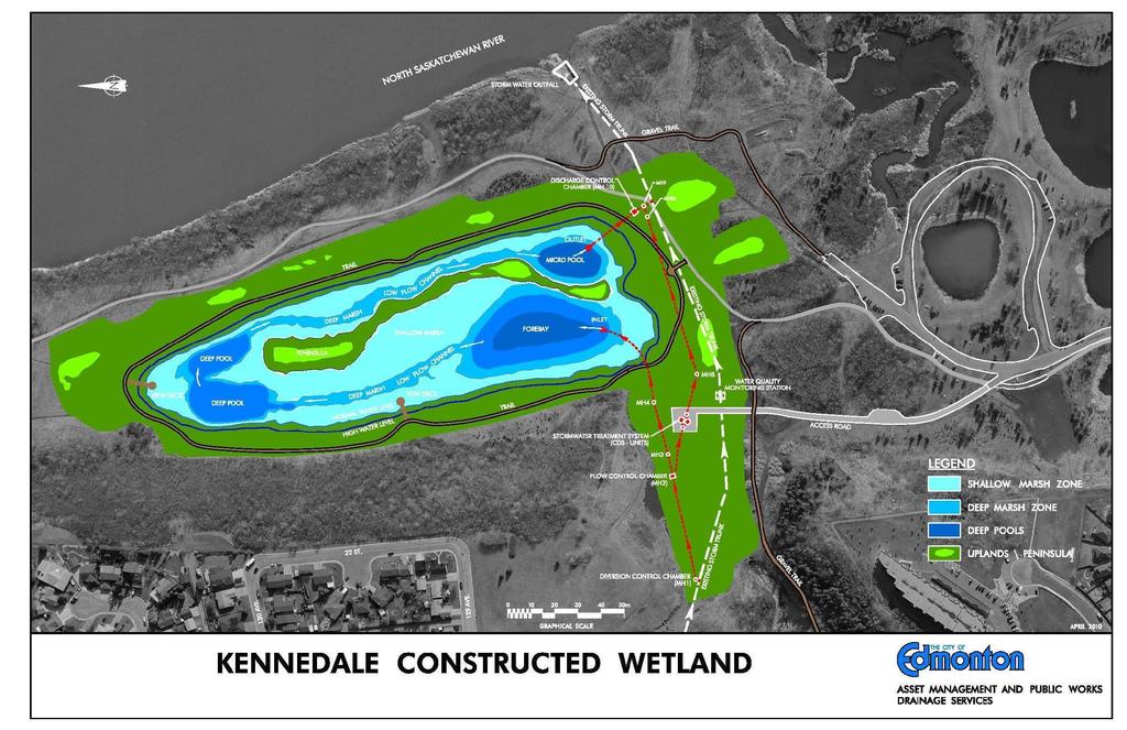
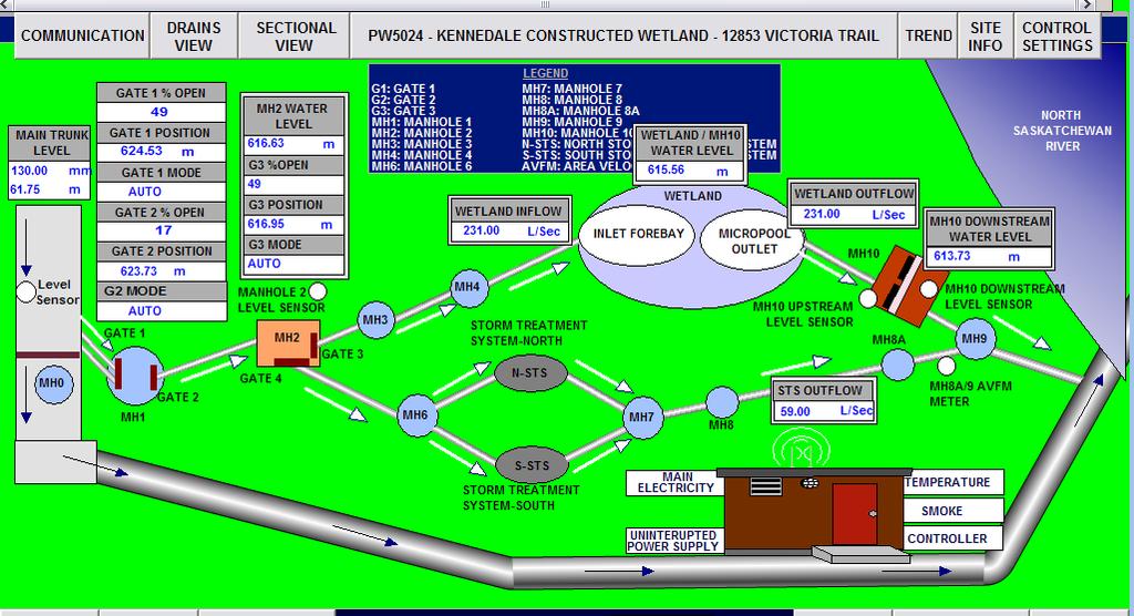
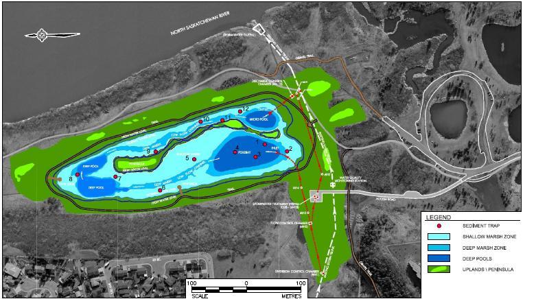
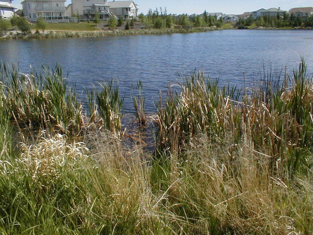
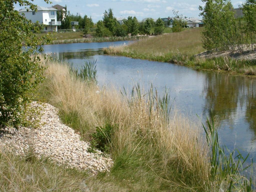
3 Kennedale Wetland Hermitage Park. Constructed: 2009 Watershed: 7,250 ha Wetland: 5 ha Storage: 50,400 m 3
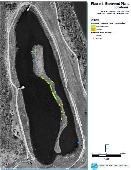
4
5
6
7 Monitoring Objectives Comparison of inflow and outflow volumes (water budget of the wetland) gave up on this. Comparison of inflow and outflow water quality. Statistical validation of results (removal efficiency statistically different then zero). How does efficiency vary from pollutant to pollutant (TSS, nutrients, bacteria)? Does efficiency improve, decay, or remain stable over time (ongoing monitoring and results)? Constructed wetland s efficiency vs. STS units efficiency? Sediment accumulation
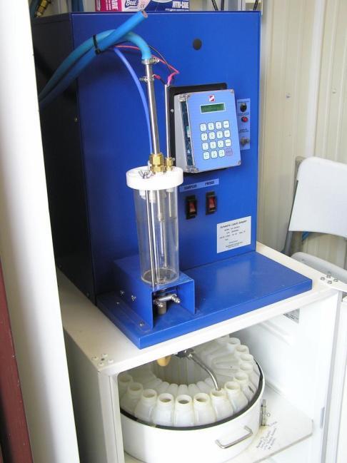
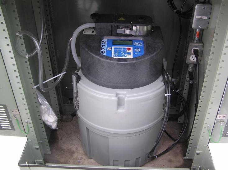
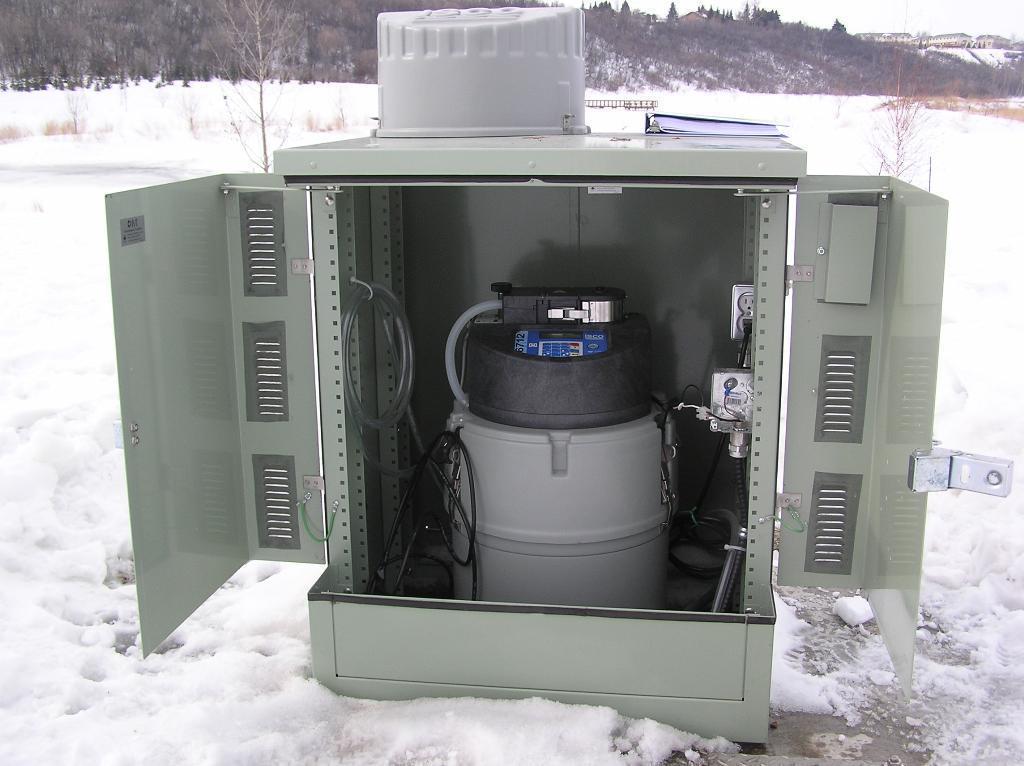
8 Monitoring Scope Baseflow weekly at inlet MH1, outlet MH10 and wetland reduced to monthly and in 2011 dropped completely (low concentrations). Rain event collect FW composite at MH1 and MH10 Rain event collect grab sample at MH8 D/S from STS units Forebay sediment accumulation - bathymetric survey Parameters included: TSS, TP, TKN, ammonia, Nitrate+Nitrite, Cl, E.Coli. Metals and pesticides (one baseflow and two storm events).

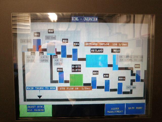
9 Kennedale Wetland Samples
10 Results and Efficiency Efficiency calculated: Calculated for each event, overall (baseflow and wet weather) and for each parameter.
11 Results and Efficiency Removal Efficiency highly dependant upon the parameter and flow conditions (baseflow or wet weather) TSS and E.Coli high removal rate and TKN had moderate removal rate during the storm TP had low and negative removal Ammonia and NO2+NO3 had negative removal efficiencies however the concentrations entering and leaving wetland were not significantly different.

12
13 Sediment Monitoring
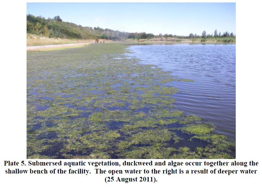
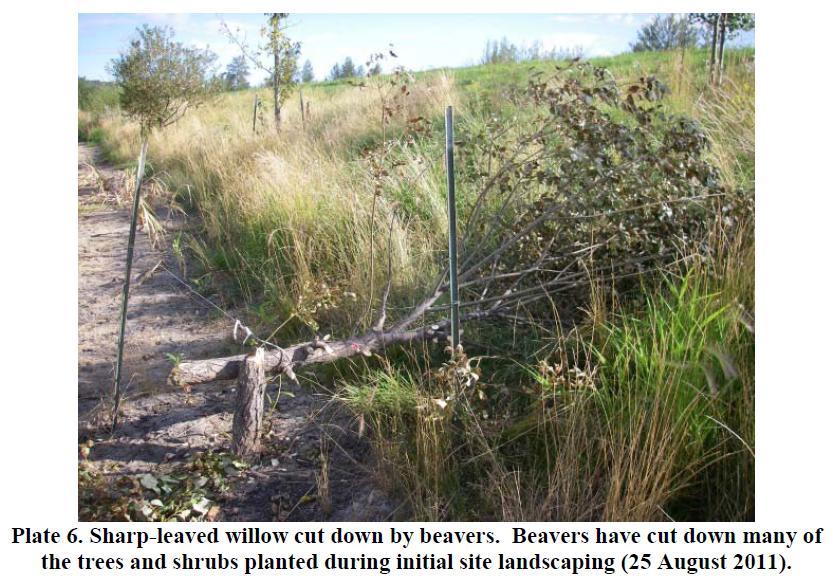
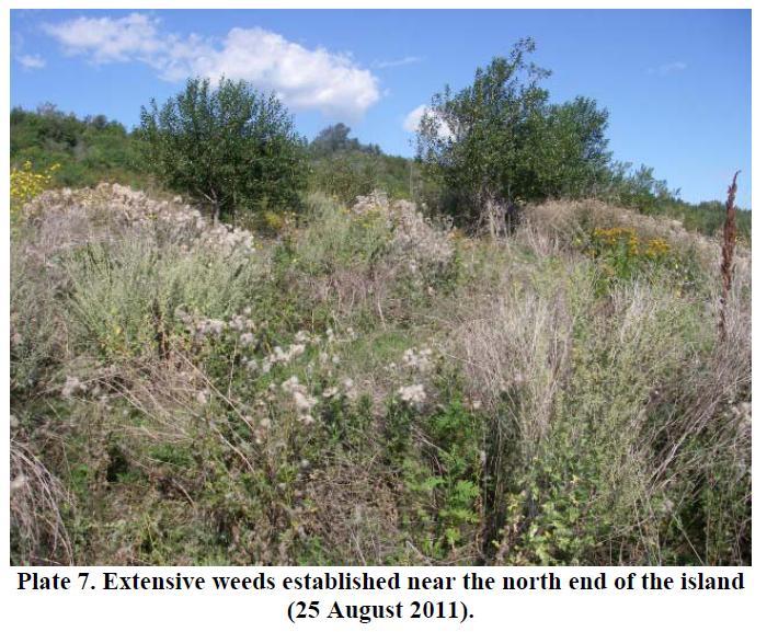
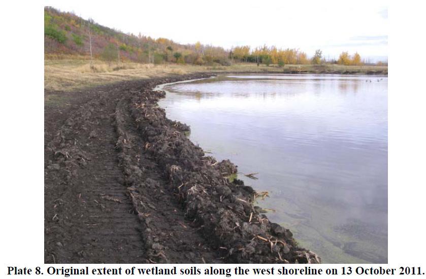
14
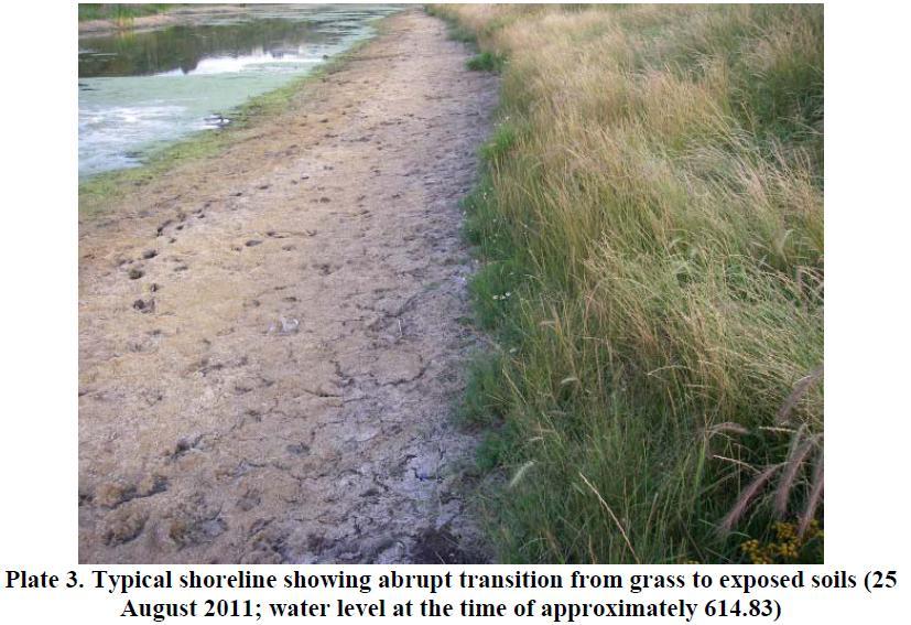
15

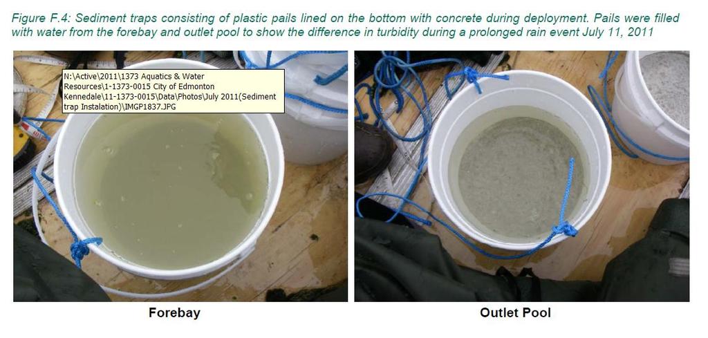
16 Sediment trap No. 4 retrieved from forebay note clay/silt sediment and that pale is overfilled
.")
17 CDS unit screen July 13, 2011 (releases from Snow Storage).

18 Forebay Bathymetric Profile
19 North and South transect
20 Cumulative volume at various depths
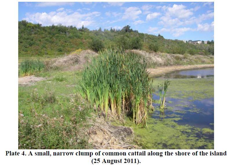
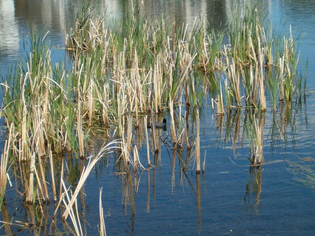
21 Vegetation Management Wetland plant communities not established as desired (2011) Mapping of current plants, water level monitoring and recommendations for remedial measures. Monitoring in 2012 to access the success of the remedial measures.

22 High water level restricts establishment of plants High precipitation immediately after construction completion Record wetland plant species and abundance Record and map emergent plants at site Provide recommendations for vegetation management within the site. Performance monitoring (established quadrants, counted plants, assess initial survival)
23
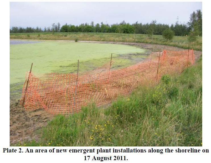
24 Recommendations Lower the water level in late summer, fall and winter below NWL (0.40m below) Install additional wetland plants (plugs of common cattail and soft stem bulrush). Use snow fencing to protect the new plant installation Bring in wetland soil (organic soil and remnant plant material) from other wetland site in the City.
25
26
27
28
29 Recommendations Winter 2011/2012 water level back to NWL Allow for spring water level to rise but only for a few days and lower it again to allow the growth of rhizomes. Gradual drawdown to below NWL by June 2012 Allow only for partial and occasional flooding and lower water level by fall

30 City of Edmonton Biological Monitoring of City of Edmonton Wetlands and Stormwater Facilities
31 Program Objectives To assess if and how well constructed wetlands are fulfilling biological wetland functions and providing related wetland values. By examining biological parameters Using a comparative approach - examine different site types- wet ponds, constructed wetlands, natural wetlands By selecting sites with varying physical features Size, age, location and surrounding land use
32 Year Focus Wet Pond Naturalized Wet Pond Constructed Wetland Natural Wetland Stormwaterinfluenced Total Sites 2007 Pilot year All site types 1 _ Less site variability Natural wetlands only _ Upland areas/ connectivity _ _ Constructed wetlands only Constructed and natural wetlands Resample 2 sites 4 _ 1 5 TOTAL SITES
33 Biological Parameters Examined Year Plants Benthic Invertebrates Amphibians Fish Birds Mammals (Tracking) (1 site only) -
34 Five Year Summary Biologically-meaningful metrics selected for inclusion. Native upland and wetland plant richness, exotic species richness Percent of uplands manicured Proportional representation of wetland communities Richness and diversity of breeding waterbirds and landbirds Maximum calling code for amphibians Weighted wetland-dependent and wetlandindependent habitat value. Relationship between site habitat value and area of woody communities. Presence of bird and mammal species that indicate connectivity.
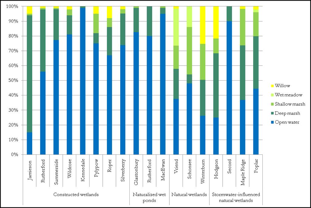
35 Five Year Summary Results: Vegetation Constructed wetlands and naturalized wet ponds had greatest number of native upland species. Natural wetlands had greatest number of native wetland plants, but stormwater-influenced wetlands had fewest. Constructed wetland types had more exotics and manicured upland than natural types.
36
37 Five Year Summary Results: Birds Natural wetland types had greater richness and diversity of breeding waterbirds than constructed types. Natural wetlands types also had greater richness and diversity of breeding landbirds. Natural wetlands scored higher than stormwater-influenced wetlands on bird metrics. Naturalized wet ponds scored higher on landbird metrics than constructed wetlands, waterbirds showed the opposite trend.


38 Five Year Summary Results: Ecological Connectivity Natural wetlands scored highest: outside/fringe of developed urban areas. All other types (wet pond excluded) scored similarly.


39 Five Year Summary Results: Amphibians Natural wetlands scored higher than constructed wetland types. However, amphibians were present at all site types.
40 Five Year Summary Results: Habitat Value Natural wetlands scored highest. Other three types scored considerably lower. Constructed wetlands had secondhighest score. Greater area of woody communities was positively associated with greater site habitat value. Woody habitats contribute to greater wetland function.
41 Five Year Summary Results: Facility Age Most metrics were not significantly influenced by age. Age is positively correlated with: Wetland-dependent habitat value Upland plant species richness But negatively correlated with: Abundance of amphibians
42 Conclusions Five Year Summary Un-integrated wetlands performed better than integrated ones. Stormwater-integrated wetlands and constructed wetlands performed equally well in many respects. Weed management is an issue for upland communities at constructed wetland types. Natural types appear somewhat resilient. Development of shallow marsh and wet meadow communities is poor at constructed wetland types.
43 Conclusions Five Year Summary It is unclear whether amphibians are able to successfully reproduce in urban wetlands. Facility age was a weak predictor of performance, suggesting other factors (hydrology?) may be more influential. Woody habitats contribute positively to site habitat value and wetland function.
44 Five Year Summary Recommendations Planted Beds - Explore installing and management options for encouraging development of diverse, native-dominated understorey communities. Establish nest box maintenance programs. Continue to monitor water level manipulation at Kennedale and its benefits (include additional sites)? Continue to research/monitor success of aquatic plantings.
45 Five Year Summary Recommendations Continue to monitor Poplar Lake to determine long-term sustainability of stormwaterinfluenced wetlands. At future constructed wetlands, strive to establish expansive riparian shrub communities. Address dense concentrations of weeds as part of regular maintenance.
46 Design/Maintenance Recommendations Wetland Components Ensure that largest open water patch is >0.5 ha. Establish an expansive emergent zone. Do not create hard-surface shorelines. Create the shallowest slopes possible. Create an undulating shoreline to increase waterbird density. Ensure that much of the shoreline is bordered by shrubby communities.
47 Design/Maintenance Recommendations Upland Components Establish a minimum 30m wide upland buffer comprising natural or naturalized plant communities. Establish a significant proportion of unmanicured herbaceous vegetation. Do not use exotic species in landscaping. Implement stringent weed management during the first five years of facility operation.
48 Design/Maintenance Recommendations Upland Components Consider seeding native forbs and grasses in planted beds to encourage the development of native-dominated understorey communities. Reconsider the use of mulch as a ground cover, and its potential role in limiting native understorey development. Integrate retained natural areas and/or create/retain structural connectivity.
49 Operation Issues Depth of facility Shallow prevents easy access (multiple launch points required). Shallow promotes algae and weed growth (light and heath penetration), depletion of oxygen and reduces effectiveness of algaecide. Shallow warm anaerobic areas are source of odours and main reason for complaints.
50 Operation Issues Shape and other features Narrow areas easily overgrown (dense vegetation prevents water flow). Stream/creek like features through NBH limited access and residential constraints. Weirs underdesigned (not holding the water during spring melt or big events) causing erosion. Gates and control structures need to be standardized. Underdesigned settling ponds (overloaded during the construction). Bridges and viewing platforms are prone to erosion (multiple departments involvement).
51 Operation Issues Citizen s Expactations High and unrealistic expectation. Facilities are specifically designed to prevent downstream flooding (due to development), remove the pollutants from the surface runoff and provide ecological balance (lost due to development).
52 Other Issues Operation Issues Landscaped close to NWL trees, shrubs and other vegetation not suitable for high water table, having problems to establish and maintain this vegetation. Live soil vs. non-live soil live soil improves establishment of aquatic plants (water treatment, erosion control and other benefits). Lack of erosion control in surrounding areas (during construction) resulting in increased sediment deposits in newer facilities.
53 Other Issues Operation Issues Boatlaunch and access ramps are not constructed for long term usage. o Interlocking brick quickly becomes overgrown with vegetation making them slippery under wet conditions. Erosion along edges of the brick leads to damage of side-slopes and base layer o Unrelated (to SWMF) planters, flower beds, park benches, garbage receptacles, mail boxes,, limit access to boat launches and the facility (equipment).
54 Questions?
55 Liliana Malesevic Drainage Services, City of Edmonton
Natural and Engineered Wetlands for Stormwater Management
 Natural and Engineered Wetlands for Stormwater Management Dan Hitchcock, Ph.D., P. E. Baruch Institute of Coastal Ecology and Forest Science Clemson University Georgetown, SC Prominence and Diversity of
WATERSHED. Maitland Valley. Report Card 201
 Maitland Valley WATERSHED Report Card 201 The Maitland Valley Conservation Authority has prepared this report card as a summary on the state of our forests, wetlands, surface water, and ground water resources.
The Importance of Riparian Forests
 The Importance of Riparian Forests By Jean Llewellyn Monroe County is the second fastest growing county in Pennsylvania. This rapid growth can be problematic because uncontrolled and unregulated growth
Design Features of Constructed Wetlands for Nonpoint Source Treatment. September 1995
 Design Features of Constructed Wetlands for Nonpoint Source Treatment September 1995 Brochure written by William W. Jones, School of Public and Environmental Affairs, Indiana University, Bloomington, Indiana.
Maitland Valley WATERSHED
 Maitland Valley WATERSHED Report Card 2018 Maitland Conservation has prepared this report card as a summary of the state of your forests, wetlands, and water resources. WHERE ARE WE? We are one of 36 Conservation
MnRAM Guidance on Selected Questions
 MnRAM Guidance on Selected Questions 1 1 Formula: Vegetative Integrity/Diversity There are four ways to report this function: Individual Community Scores: maintain raw data as recorded. Highest Quality
4. What is Item A called? a. Eckman dredge b. Secchi disk c. Van Dorn sampler d. Ponar sampler
 Envirothon Questions for AQUATICS station April 24, 2013 1. Eutrophication often results in large fish kills. What is the major cause of these fish kills? a. Oxygen has been depleted due to the decay of
Natural Shoreline Landscapes on Michigan Inland Lakes
 Natural Shoreline Landscapes on Michigan Inland Lakes Excerpts from Chapters 2 and 3 Session topics Characteristics of natural and altered shorelines Lakes, shorelines, habitat and water quality Considerations
Gray s Creek. Gray s Creek
 Gray s Creek 1 Grades F + Forest Conditions B Wetland Conditions C - Surface Water Quality This Watershed Report Card outlines the environmental information for the Gray s Creek watershed as of 2017. The
A Nutrient Mass Balance of the Watershed Research and Education Center: Where, When and How Much?
 A Nutrient Mass Balance of the Watershed Research and Education Center: Where, When and How Much? BRIAN E. HAGGARD, JOHN T. METRAILER, DIRK PHILIPP, J. VAUGHN SKINNER, J. THAD SCOTT, AND ANDREW N. SHARPLEY
Constructed Wetland Pond T-8
 Constructed Wetland Pond T-8 Description A constructed wetlands pond is a shallow retention pond designed to permit the growth of wetland plants such as rushes, willows, and cattails. Constructed wetlands
SECTION 10: WETLANDS PROTECTION
 SECTION 10: WETLANDS PROTECTION 10-1 INTENT AND PURPOSE A. Intent 1. The City finds that wetlands serve a variety of beneficial functions. Wetlands maintain water quality, reduce flooding and erosion,
WASA Quiz Review. Chapter 2
 WASA Quiz Review Chapter 2 Question#1 What is surface runoff? part of the water cycle that flows over land as surface water instead of being absorbed into groundwater or evaporating Question #2 What are
Recommended Wetland Management Standards According to Management Class
 Recommended Wetland Management Standards According to Management Class Measure Management Strategy Management Class Preserve Manage 1 Manage 2 Manage 3 Maintain wetland and existing functions, values and
Red Clover/McReynolds Creek Restoration Project Monitoring Report Ryan Nupen fly fishing in project area June (Photo G.
 Red Clover/McReynolds Creek Restoration Project Monitoring Report 2010 Ryan Nupen fly fishing in project area June 2010. (Photo G. Martynn) Feather River Coordinated Resource Management Plumas Corporation
Hydrology 101. Impacts of the Urban Environment. Nokomis Knolls Pond Summer June 2008
 Hydrology 101 Nokomis Knolls Pond Summer 2002 Impacts of the Urban Environment Hydrologic Cycle; What is it? Geography, Topography, Geology, Land Cover and Climate determine the Amount and Behavior of
Basic Information: Individual Vernal Pool
 Basic Information: Individual Vernal Pool Assessment Area Name: Project Name: Assessment Area ID #: Project ID #: Assessment Team Members for This AA Date: AA Location: Latitude: Longitude: Datum: Wetland
Carp Creek 2013 Summary Report
 Monitoring Activity in the Carp River Watershed In 2012, Mississippi Valley Conservation Authority (MVCA) worked with Friends of the Carp River (FCR) on a preliminary assessment of the Carp River. This
Logan River at Rendezvous Park, Channel and Floodplain Restoration: Crack Willow (Salix fragilis) Issues and Management Strategies
 Issues and Management Strategies") Logan River at Rendezvous Park, Channel and Floodplain Restoration: Crack Willow (Salix fragilis) Issues and Management Strategies Prepared May 2, 2017 by Darren Olsen, BIO-WEST, Inc. Issues Crack willow
Logan River at Rendezvous Park, Channel and Floodplain Restoration: Crack Willow (Salix fragilis) Issues and Management Strategies Prepared May 2, 2017 by Darren Olsen, BIO-WEST, Inc. Issues Crack willow
Freshwater Ecosystems
 Freshwater Ecosystems The types of organisms in an aquatic ecosystem are mainly determined by the water s salinity. As a result, aquatic ecosystems are divided into freshwater and marine ecosystems. Freshwater
Ecological Considerations in Setting MFLs and Lake Regulation Targets for the Ocklawaha Chain of Lakes
 Ecological Considerations in Setting MFLs and Lake Regulation Targets for the Ocklawaha Chain of Lakes Rolland Fulton, Ph.D. Environmental Scientist VI Bureau of Environmental Sciences St. Johns River
The Colley Bay Story: Successful Implementation of a Living Shoreline
 The Colley Bay Story: Successful Implementation of a Living Shoreline Definition Living Shoreline Treatments address erosion in lower energy situations by providing long-term protection, restoration or
Otonabee Region WATERSHED
 Otonabee Region WATERSHED Report Card 2018 Otonabee Conservation has prepared this report card as a summary of the state of your forests, wetlands, and water resources using data from 2012 to 2016. WHERE
SECTION 1 FRESHWATER SYSTEMS UNIT 4: AQUATIC ECOLOGY
 SECTION 1 FRESHWATER SYSTEMS UNIT 4: AQUATIC ECOLOGY CENTRAL CASE STUDY: STARVING THE LOUISIANA COAST OF SEDIMENT LOUISIANA IS LOSING 25MI2 OF COASTAL WETLANDS ANNUALLY WETLANDS SUPPORT A DIVERSITY OF
Stormwater Management in Your Backyard: Stormwater 101
 Stormwater Management in Your Backyard: Stormwater 101 Gregory Rusciano Program Associate, Water Resources Rutgers Cooperative Extension New Jersey Sea Grant Extension Program How much water do we have?
Chapter 2. Watershed Characteristics
 Chapter 2. Watershed Characteristics The Pelican Lakes are glacial lakes formed during the last retreat of the Red River Lobe starting about 13,000 years ago. The soils deposited by the glacier are primarily
H ollow R iver. Stewardship Works! S ubwatershed. Grades. Land Water Wetlands Biodiversity. Not Stressed Not Stressed Not Stressed Vulnerable
 s H ollow R iver Land Water Wetlands Biodiversity S ubwatershed T he Hollow River Subwatershed is 40,863 hectares in size and lies predominantly in the Township of Algonquin Highlands in Haliburton County.
B ig E ast R iver. Stewardship Works! S ubwatershed. Grades. Land Water Wetlands Biodiversity. Not Stressed Not Stressed Not Stressed Vulnerable
 s B ig E ast R iver Land Water Wetlands Biodiversity S ubwatershed T he Big East River Subwatershed is 64,699 hectares in area. Major lakes in the subwatershed include Bella Lake (3.45 km2) and Rebecca
Lesson 2-2: Riparian Zones
 2-14 Lesson 2-2: Riparian Zones Time of Lesson: 1 hour Rationale: The purpose of this lesson is to define what a riparian zone is and link its importance for fish and other animals, and humans, and the
THE IMPORTANCE OF NATURAL WATERSHED HYDROLOGY AND HOW TO ADVANCE IT IN URBAN AREAS
 THE IMPORTANCE OF NATURAL WATERSHED HYDROLOGY AND HOW TO ADVANCE IT IN URBAN AREAS Pacific Northwest Forest Hydrology Surface runoff rare, slow sheet flow when it occurs Trees Intercept rainfall, evaporate
Lake & Watershed Resource Management Associates P O Box 65; Turner, ME
 Lake & Watershed Resource Management Associates P O Box 65; Turner, ME 207-336-2980 LWRMA@megalink.net 2008 Baseline Water Quality Monitoring and Assessment of Pemaquid and Biscay Ponds At the request
Slide 1: Welcome to today s The Nitrogen Cycle presentation, where we ll be talking to you about the importance of nitrogen in our environment.
 Slide 1: Welcome to today s The Nitrogen Cycle presentation, where we ll be talking to you about the importance of nitrogen in our environment. 1 Slide 2: Barnegat Bay, like many coastal areas in the country,
2017 Agricultural Water Quality Workshop
 2017 Agricultural Water Quality Workshop Focus Area Lower Lewis and Clark Clatsop SWCD has identified this area as one that needs much improvement This does not mean we can t do projects in other areas
Goose Management through Habitat Restoration
 Goose Management through Habitat Restoration presented at the Goose Management Workshop Bergen County Community College Paramus, New Jersey March 3, 2009 Christopher C. Obropta, Ph.D., P.E. Extension Specialist
Watershed. Rigaud River Report Card. Grades: Forest Conditions Wetland Conditions Surface Water Quality
 Watershed Report ard Grades: + onditions Wetland onditions Surface Water Quality This Watershed Report ard outlines the environmental information for the watershed as of 2006. The information provides
S.R. 4007, Section 14B PADEP Environmental Assessment Form. Enclosure C Description of Aquatic Habitat
 S.R. 4007, Section 14B PADEP Environmental Assessment Form Description of Aquatic Habitat Cresheim Creek is the only water resource that exists within the project area. No jurisdictional wetlands were
CLMP+ Report on Grass Lake (Anoka County) Lake ID# CLMP+ Data Summary
 Lake ID# CLMP+ Data Summary") CLMP+ Report on Grass Lake (Anoka County) Lake ID# 02-0113-00 2012-2013 CLMP+ Data Summary October 2014 Authors Shannon Martin, MPCA Editing and graphic design Public Information Office Staff The (MPCA)
CLMP+ Report on Grass Lake (Anoka County) Lake ID# 02-0113-00 2012-2013 CLMP+ Data Summary October 2014 Authors Shannon Martin, MPCA Editing and graphic design Public Information Office Staff The (MPCA)
Constructed Wetland Use in Nonpoint Source Control
 Constructed Wetland Use in Nonpoint Source Control Description Constructed wetlands are excavated basins with irregular perimeters and undulating bottom contours into which wetland vegetation is purposely
Stormwater Management Training for MS4 Municipal Employees
 Stormwater Management Training for MS4 Municipal Employees Grant Supported Through: Ohio Environmental Education Fund In Partnership: City of Cleveland Mayor s Office of Sustainability Chagrin River Watershed
National Management Measures to Protect and Restore Wetlands and Riparian Areas for the Abatement of Nonpoint Source Pollution
 EPA-841-B-05-003 July 2005 National Management Measures to Protect and Restore Wetlands and Riparian Areas for the Abatement of Nonpoint Source Pollution Chapter 2: Overview of Wetlands, Riparian Areas,
Monitoring Stormwater Best Management Practices: Why Is It Important and What To Monitor
 Monitoring Stormwater Best Management Practices: Why Is It Important and What To Monitor Scott D. Struck, Ph.D. US EPA, Urban Watershed Management Branch New Jersey Water Monitoring Workshop 4/20/2006
Design Strategies for Stormwater Wetlands to Maximize Plant Diversity
 Design Strategies for Stormwater Wetlands to Maximize Plant Diversity Introduction Stephen Mastey Stormwater is a major stressor of urban aquatic systems because of changes in water quality and quantity
Hydrology Attribute 1/15/2016. California Rapid Assessment Method for Wetlands. Hydrology. Precipitation Increases the Extent of Wetlands
 California Rapid Assessment Method for Wetlands Hydrology Attribute Hydrology Determines existence of wetlands, drives primary physical and ecological processes: Establishment of reducing conditions Nutrient
Saving Wetlands. Is saving Lives
 Saving Wetlands Is saving Lives What are Wetlands? areas between water and land What are Wetlands? contain hydric soil - saturated by water. soil lacks oxygen when saturated land that is seasonally wet.
4.12. Detention Basins
 4.12. Detention Basins Detention Basins can be a cost effective method to provide temporary storage, conveyance, and treatment of runoff when used within the context of Low Impact Development (LID) strategies.
Water Resource Protection. Today s Presentation
 Water Resource Protection Article X Ordinance Revision February 14, 2007 Today s Presentation Buffer Definitions Buffer Functions\Benefits Buffer Ordinance Purpose Overview of the Local, and State buffer
River Monitoring and Water Resource Terms
 River Monitoring and Water Resource Terms Baseflow: River discharge or flow composed of ground water drainage and delayed surface drainage. Baseflow is typically characterized as that portion of river
Jackson Lake Analysis
 Jackson Lake Analysis Lake Zones Lake Zones Limnetic Zone- open water far from shore Light penetrates shallow, allowing photosynthesis Supports phytoplankton (algae, protists, cyanobacteria) which then
NRCS Programs and Practices for Riparian Areas in Hawaii
 NRCS Programs and Practices for Riparian Areas in Hawaii NRCS Pacific Islands Area Hawaii - State (State (PIA) Office Honolulu, Oahu) Seven field offices (Kauai, Oahu, Molokai, Maui, Hawaii) Plant Materials
orking Trees for Water Quality
 W Agroforestry orking Trees for Water Quality Working Trees: a partner in watershed management. Agroforestry helps to protect water quality while achieving both landowner and community objectives. Water
Design of the Next Generation of Constructed Wetlands
 Design of the Next Generation of Constructed Wetlands AGENDA The Curious Evolution of Stormwater Wetlands The Improved Stormwater Wetland Design Key Design Choices for Stormwater Wetlands The Regenerative
Sandy Wyman Rangeland Management Specialist National Riparian Service Team SRM, Feb. 6, 2013
 Assessing Proper Functioning Condition (PFC) of Lentic Areas Sandy Wyman Rangeland Management Specialist National Riparian Service Team SRM, Feb. 6, 2013 TR 1737-16 What is PFC? How well physical processes
Wood Canyon Emergent Wetland Project. City of Aliso Viejo 12 Journey, Suite 100 Aliso Viejo, CA 92656
 Wood Canyon Emergent Wetland Project City of Aliso Viejo 12 Journey, Suite 100 Aliso Viejo, CA 92656 Introduction Wood Canyon is located within Aliso and Wood Canyon Regional Park in southwest Orange County,
Riparian Buffers and Stream Restoration
 Riparian Buffers and Stream Restoration Why focus on riparian areas? Link land and water on any given site and link landscapes together in a watershed Riparian corridors protect the circulatory system
Spanaway Lake Management Plan
 Spanaway Lake Management Plan Background Spanaway Lake is a valuable Pierce County resource. The lake is threatened by a variety of water quality problems including excess algae and weed growth and elevated
Appendix E : Guidelines for Riparian Buffer Areas
 Appendix E : Guidelines for Riparian Buffer Areas This document should be read in conjunction with the CRCA Planning Policy. 1.0 PURPOSE The purpose of this document is to summarize the recommendations
Good Housekeeping Pollution Prevention
 Good Housekeeping Pollution Prevention Oak Meadow Golf and Banquet September 12, 2008 Richard Hentschel Extension Specialist Green Industry Programming University of Illinois Sensible turf management limits
RIPARIAN CORRIDOR STUDY FINAL CITY CREEK MANAGEMENT PLAN TABLE OF CONTENTS
 TABLE OF CONTENTS 1.0 INTRODUCTION... 1-1 Riparian Corridor Study and Management Plan Goals... 1-1 Study Area... 1-2 Importance and Functions of Riparian Corridors... 1-2 Habitat for Mammals, Birds, and
Northern Chain of Lakes
 Northern Chain of Lakes Presented by Pat Conrad and Joe Pallardy on behalf of the Brown s Creek Watershed District Board of Managers w a t e r I e c o l o g y I c o m m u n i t y Lake by Lake Analysis
LIST OF APPENDICES. Appendix B. Plans of Freshwater Wetland Components and Modeled Alternatives
 LIST OF APPENDICES Appendix A. Hydrologic Budget Results Appendix B. Plans of Freshwater Wetland Components and Modeled Alternatives Appendix C. Wetland Zones Appendix D. Cost Sheets Appendix E. Alternative
STORMWATER MONITORING GUIDELINES SOUTH OF DUNDAS STREET OPERATION, MAINTENENACE AND MONITORING OF STORMWATER MANAGEMENT PONDS
 STORMWATER MONITORING GUIDELINES SOUTH OF DUNDAS STREET OPERATION, MAINTENENACE AND MONITORING OF STORMWATER MANAGEMENT PONDS STORMWATER MONITORING GUIDELINES: Operation, Maintenance and Monitoring Of
Appendix X: Non-Point Source Pollution
 Appendix X: Non-Point Source Pollution Sources Nonpoint source of pollution, unlike pollution from industrial and sewage treatment plants, comes from many different sources. Nonpoint source pollution is
Doyle Park Reconstruction Project Improving Flood Control Facilities to Meet a TMDL
 Doyle Park Reconstruction Project Improving Flood Control Facilities to Meet a TMDL Ann Arbor, Michigan Washtenaw County Drain Commissioner & Malletts Creek Coordinating Committee November, 2007 Janis
Conservation Practices for Water Quality: Sediment & Nutrient Control. Trap Sediments/Trap Nutrients on the Field. Improve Soil Health.
 Conservation Practices for Water Quality: Sediment & Nutrient Control. Trap Sediments/Trap Nutrients on the Field. Improve Soil Health. Sediment Conservation Cover Cover Crop Critical Area Planting Field
Key Strategic Goal Of the MVCA
 Garvey Glenn Shoreline watershed project Soil and Water Environmental Enhancement Plan (SWEEP) May 2012 Preface This document is a working document which has been and will continually be updated as the
Shingle Creek Watershed Management Commission Wetland 639W Outlet Modifications Summary Feasibility Report
 Shingle Creek Watershed Management Commission Wetland 639W Outlet Modifications Summary Feasibility Report The proposed project is the modification of the outlet of Wetland 27-0639W to reduce phosphorus
4.4.5 Grassed Swale (also known as Enhanced Swale or Biofiltration Swale)
") Signs of trespass or unauthorized traffic Sediment buildup Additionally, a program of regular monitoring of the aquatic environment for a permanent wet detention basin should be established to allow for
Signs of trespass or unauthorized traffic Sediment buildup Additionally, a program of regular monitoring of the aquatic environment for a permanent wet detention basin should be established to allow for
Contractors, Illicit Discharges, & Best Management Practices. Chris Allen Stormwater Inspector
 Contractors, Illicit Discharges, & Best Management Practices Chris Allen Stormwater Inspector What is an Illicit Discharge? Georgetown County Stormwater Ordinance defines an Illicit Discharge as: Any activity
Nutrient distributions and the interaction between coastal wetlands and the nearshore of Lake Ontario
 Nutrient distributions and the interaction between coastal wetlands and the nearshore of Ontario Krista Chomicki and Gary Bowen International Association of Great s Research, 25 Type Durham Region Coastal
Introduction. Wetland System. A Wetland Scene at Lorne C. Henderson Conservation Area near Petrolia
 Wetland Treatment of Wastewater This monograph, one in a series of single issue documents that deal with our local environment, has been prepared by the Sarnia-Lambton Environmental Association in co-operation
California Rapid Assessment Method for Wetlands (CRAM) Buffer and Landscape Context Attribute
 Buffer and Landscape Context Attribute") California Rapid Assessment Method for Wetlands (CRAM) Buffer and Landscape Context Attribute Buffer and Landscape Context Attribute Presence and/or continuity of wetlands and riparian areas adjacent to
California Rapid Assessment Method for Wetlands (CRAM) Buffer and Landscape Context Attribute Buffer and Landscape Context Attribute Presence and/or continuity of wetlands and riparian areas adjacent to
1/16/2016. California Rapid Assessment Method for Wetlands (CRAM) Buffer and Landscape Context Attribute. Buffer and Landscape Context Attribute
 Buffer and Landscape Context Attribute. Buffer and Landscape Context Attribute") California Rapid Assessment Method for Wetlands (CRAM) Buffer and Landscape Context Attribute Buffer and Landscape Context Attribute Presence and/or continuity of wetlands and riparian areas adjacent to
California Rapid Assessment Method for Wetlands (CRAM) Buffer and Landscape Context Attribute Buffer and Landscape Context Attribute Presence and/or continuity of wetlands and riparian areas adjacent to
Biofilter Wetland at Harrow Run Water Quality Evaluation of Pollutant Removal Efficiency from a Tailwater Recovery System
 Objective and Scope Biofilter Wetland at Harrow Run Water Quality Evaluation of Pollutant Removal Efficiency from a Tailwater Recovery System In November of 2004, a biofilter wetland was installed to treat
Multipurpose Wetland Creation and Restoration to Improve Water Quality and Wildlife Habitat in Coastal Urban Bayous
 Multipurpose Wetland Creation and Restoration to Improve Water Quality and Wildlife Habitat in Coastal Urban Bayous CEER 2014 New Orleans, LA George Guillen, Misty Shepard, K. Vale and J. Oakley Environmental
Town of Aurora Stream Management Master Plan PUBLIC INFORMATION CENTRE May 1 st, 2018
 Town of Aurora Stream Management Master Plan PUBLIC INFORMATION CENTRE May 1 st, 2018 Your comments are encouraged and appreciated, as this will provide us an opportunity to address project issues and
2017 MB Envirothon. Theme Training Document
 2017 MB Envirothon Theme Training Document Envirothon Training Soil and Water Conservation Stewardship: Beneficial Management Practices Types of BMPs Water Management BMPs: Water Retention Wetland Restoration
Standard for Wet Ponds
 New Jersey Stormwater Best Management Practices Manual February 2004 Definition Purpose C H A P T E R 9. 1 1 Standard for Wet Ponds A wet pond is a stormwater facility constructed through filling and/or
From My Backyard to Our Bay It s the 911 for the Chesapeake Bay
 From My Backyard to Our Bay Reporting Problems on Our Bay, Rivers, and Streams We can all be the eyes and ears of our local waterways. Maryland has established the Chesapeake Bay Safety and Environmental
Watershed Health and Water Management in the Porcupine Hills
 Watershed Health and Water Management in the Porcupine Hills In Alberta, our quality of life is tied to healthy and sustainable water supplies for the environment, for our communities, and for our economic
4. Ponds and infiltration BMPs can achieve 60 to 100% removal efficiencies for sediment.
 Landscape BMPs For the purposes of this project, preventive measures have been categorized into two categories: landscape BMPs and source prevention BMPs. Landscape BMPs includes both vegetative practices
Constructed Wetland Channel T-9
 Description A constructed wetland channel is a conveyance BMP that is built, in part, to enhance stormwater quality. Constructed wetland channels use dense vegetation to slow down runoff and allow time
Maintaining Riparian Areas and Wetlands
 Maintaining Riparian Areas and Wetlands Riparian areas are the lands along the banks of our rivers, lakes, and tidal waters. Many riparian areas not only border surface waters, but they are often adjacent
Aquatic Science Unit 1. Introduction to Freshwater Ecology
 Aquatic Science Unit 1 Introduction to Freshwater Ecology Water is essential to life Water is essential to the survival of all living things No living organism can survive without water Humans cannot go
Discuss. With the members of your table, discuss these two questions and come up with a list:
 WETLANDS Discuss With the members of your table, discuss these two questions and come up with a list: 1) There are 3 defining qualities that makes a piece of land a wetland. Name the 3 qualities that would
Wetland restoration and monitoring on the Chevelon Wildlife Area
 Wetland restoration and monitoring on the Chevelon Wildlife Area Michael Ingraldi, Ph.D. Research Branch Arizona Game and Fish Department Phoenix, Arizona 85023 The Chevelon State Wildlife Area is located
Wildlife Management Planning Guidelines for the South Texas Plains Ecoregion
 Habitat Control Practices Required Intensity Description Grazing Management Prescribed Burning Range Enhancement (Range Reseeding) Brush Management Riparian Management and Enhancement Wetland Enhancement
2017 Data Report for Rogers Pond, Mecosta County
 Michigan Lakes Ours to Protect 2017 Data Report for 43.6175478 N, 85.4718313 W The CLMP is brought to you by: 1 About this report: This report is a summary of the data that have been collected through
3.6 Riparian Ecosystem Wildlife
 3.6 Riparian Ecosystem Wildlife 3.6.1 Introduction and Methodology Riparian areas and associated wetlands are widely recognized for the significant and diverse roles they play in the landscape. They clean
October 2015 Utilizing a County-Owned Golf Course for Watershed Restoration in Gwinnett County, GA
 October 2015 Utilizing a County-Owned Golf Course for Watershed Restoration in Gwinnett County, GA Arvind Narayanan, P.E.*, CFM, Water Resources Engineer Overview Project Identification Project Implementation:
Shallow Lake Ecology and Management. Todd Call Shallow Lakes Program
 Shallow Lake Ecology and Management Todd Call Shallow Lakes Program Two Concepts to Take Away Shallow lakes can exist in two states Clear Water (Preferred for wetland wildlife) Turbid Water Fish and nutrients
Freshwater ecosystems
 Aquatic Ecosystems Aquatic Ecosystems The types of organisms in an aquatic ecosystem are determined by the water s salinity. Salinity - Amount of salt in the water. Freshwater ecosystems do not have any
DEVELOPING A WATERSHED IMPROVEMENT PLAN TO MEET MULTIPLE COMMUNITY OBJECTIVES IN GAINESVILLE AND HALL COUNTY, GEORGIA
 DEVELOPING A WATERSHED IMPROVEMENT PLAN TO MEET MULTIPLE COMMUNITY OBJECTIVES IN GAINESVILLE AND HALL COUNTY, GEORGIA Chrissy, Thom 1, David Dockery 2, Kevin McInturff 3, Betsy Massie 1, and Lauren Murphy
Restoration Mitigation Impacted Ambient Reference Training
 Basic Information Sheet: Perennial Estuarine Wetlands Assessment Area Name: Project Name: Assessment Area ID #: Project Site ID #: Date: Assessment Team Members for This AA Center of AA: Latitude: Wetland
BMP 5.4.2: Protect /Conserve/Enhance Riparian Areas
 BMP 5.4.2: Protect /Conserve/Enhance Riparian Areas The Executive Council of the Chesapeake Bay Program defines a Riparian Forest Buffer as "an area of trees, usually accompanied by shrubs and other vegetation,
Infiltration Basin Description Applicability
 Infiltration Basin Description An infiltration basin is a shallow impoundment which is designed to infiltrate storm water into the ground water. This practice is believed to have a high pollutant removal
Conservation Practices. Conservation Choices. These five icons will show the benefits each practice offers... 6/4/2014
 Conservation Choices Your guide to conservation and environmental farming practices. Conservation Choices These five icons will show the benefits each practice offers... The practice reduces soil erosion
Tuesday, March 7, 17. Ecology: Chapter 10. Aquatic Biomes
 Ecology: Chapter 10 Aquatic Biomes Aquatic habitats= one in which the organisms live in or on Not grouped geographically the way terrestrial biomes are Difficult to be shown on a map Scattered Two types:
Scientific overview: Water quality functions of coastal buffers
 Scientific overview: Water quality functions of coastal buffers Caitlin Chaffee, Coastal Policy Analyst RI Coastal Resources Management Council November 21, 2013 Buffer Zone Setback = Minimum Distance
Urban Riparian & Stream Restoration Program: Management & Photo Monitoring. Texas Water Resource Institute
 Urban Riparian & Stream Restoration Program: Management & Photo Monitoring Texas Water Resource Institute Hindrances to Healthy / Functional Riparian Areas: Farming too close to the bank Mowing, spraying
Managing near Vernal Pools using Good Forestry in the Granite State
 Managing near Vernal Pools using Good Forestry in the Granite State Matt Tarr Associate Extension Professor Wildlife Specialist University of New Hampshire Cooperative Extension NESAF Conference March