Appendix E Pump Test Report
|
|
|
- John Greene
- 6 years ago
- Views:
Transcription
1 Appendix E Pump Test Report
2 GROUND-WATER EXPLORATION PROGRAM LEGACY RIDGE, TOWN OF WOODBURY, NEW YORK Prepared For: Legacy Ridge August 2007 Prepared By: LEGGETTE, BRASHEARS & GRAHAM, INC. Professional Ground-Water and Environmental Engineering Services 4 Research Drive, Suite 301 Shelton, CT 06484
3 TABLE OF CONTENTS Page INTRODUCTION...1 DRILLING EXPLORATION PROGRAM...1 Bedrock Aquifer...2 Sand and Gravel Aquifer...2 TW-A...3 PW INSTALLATION OF PIEZOMETER...3 INSTALLATION OF PRESSURE TRANSDUCERS HOUR PUMPING TEST...4 WELL MONITORING PROGRAM...5 Long-Term Yield of PW WATER QUALITY...6 CONCLUSIONS...6
4 GROUND-WATER EXPLORATION PROGRAM LEGACY RIDGE, TOWN OF WOODBURY, NEW YORK INTRODUCTION Leggette, Brashears & Graham, Inc (LBG) conducted an additional groundwater exploration program, aquifer testing program, and groundwater quality assessment on the Legacy Ridge parcel in the Town of Woodbury, NY. The objective of the groundwater exploration program was to locate, install test wells and perform aquifer performance test to demonstrate sufficient yield to augment the existing water-supply sources. Figure 1 shows the location of the site in the Town of Woodbury, Orange County, New York along with the existing production wells, test wells, monitoring wells, and piezometers used during the aquifer performance test. DRILLING EXPLORATION PROGRAM The additional exploration program conducted by LBG included test well drilling completed in both the bedrock and sand and gravel aquifers from March to June To date, three bedrock test wells and two sand and gravel test wells have been completed. The following is a discussion of the preliminary yield estimate of the test wells from the bedrock and sand and gravel aquifers, including data from a 24+ hour pumping test event conducted on a successful high-yield sand and gravel well (PW-1). A previous ground-water exploration program conducted by HDR Engineering, Inc. (HDR) in 2005 on the study parcel developed three successful sand and gravel production wells identified as TW-1, TW-2 and TW-4; with respective yields of 290, 120 and 34 gpm. The wells are shown on figure 1. Details of the well completion reports of the existing water supply wells and monitoring wells completed under the supervision of HDR are provided in the report Groundwater Exploration and Hydrogeologic Report, Town of Woodbury, Orange County, NY by HDR, Inc., January 2006.
5 -2- Bedrock Aquifer The bedrock geologic map from the Orange County New York, Ground-Water Resources Study (LBG, May 1995) shows complex bedrock geology on the study parcel. The initial bedrock well drilling program considered an area north of Trout Brook Road and west of Route 9 (Mineral Spring Road). A prominent northeast to southwest trending trust fault bisects this portion of the study parcel, separating a granitic gneiss bedrock unit on the north of the fault; and Undifferentiated Lower Devonian and Silurian Rocks consisting of sandstone, shale and conglomerate rock units on the southern side of the fault. Fracture-trace maps were interpreted with additional layers of topography; bedrock geology; underling faults; geologic contacts; wells inventoried; sand and gravel deposits; and State and Federal wetlands to locate favorable locations to target high-yielding bedrock well. Locations which exhibit more than one of the above features are considered to be promising for drilling high-yielding bedrock well and the sites initially considered on the study parcel for drilling test wells exhibited a number of these favorable features. Three bedrock test wells were drilled by Turnbull Well Drilling, Inc. from March to April of 2007 under the supervision of LBG. Bedrock test wells 1, 2 and 3 (BRW-1, 2, and 3) are shown on Figure 1. The well completion reports are presented in Appendix I. All three bedrock test wells yielded about 30 gpm at termination of drilling. The project team decided to terminate the bedrock test well drilling at completion of BRW-3, considering the well yields were considered marginal for the development of public water-supply sources. Sand and Gravel Aquifer Layne Christensen Company (Layne) was contracted in April of 2007 to drill test well locations in the sand and gravel aquifer, north of Trout Brook on the study parcel. The initial drilling program completed three test borings (TB-1, 2 and 3) in the vicinity of BRW-1. Sand and gravel aquifer material was encountered in this area during drilling; however, the material was determined to not be suitable for the development of a high-yielding well. The test boring reports for TB-1, 2 and 3 are presented in Appendix II. LBG supervised the drilling of the two additional test borings and test wells drilled by Layne in June of The two six inch diameter test wells were completed as TW-A and PW-1
6 -3- (figure 1). The test boring reports and well construction diagrams for TW-A and PW-1 are located in Appendix II. TW-A TW-A was completed at a depth of 112 feet below land surface (bls). The well was screened from 102 to 110 feet bls with a 60-slot stainless steel screen. The well was screened in suitable sand and gravel aquifer material. A dense gray clay layer about 40-feet in thickness was encountered at a depth of 10 to 50 feet bls. The underlying bedrock was encountered at 112 feet bls and was composed of sandstone. The well was developed with repeated surging and pumping. PW-1 PW-1 was completed at a depth of 87 feet bls. The well screen was set at 80 to 87 feet bls with a 90-slot stainless steel screen. The well was screened in suitable sand and gravel aquifer material. Similarly a dense gray clay layer about 20-feet in thickness was encountered at a depth of 10 to 30 feet bls. The bedrock was encountered at 90 feet bls and was composed of black shale. The well was developed with repeated surging and pumping. The initial pumping conducted during development indicated PW-1 had the higher yield potential, therefore, a shortterm 24-hour pumping test was recommended on this well to determine the yield potential of a larger diameter production well. INSTALLATION OF PIEZOMETER A 1.25-inch diameter piezometer (PZ-A) was installed in the middle of the Trout Brook at a distance of about 60 feet from the test well (PW-1). A 12-inch length stainless steel screen (with drive point and coupled steel pipe) was driven into the bottom of the stream sediments to a depth of 3.73 feet. The piezometer was developed by repeated well surging. The location of PZ-A is shown of figure 1.
7 -4- INSTALLATION OF PRESSURE TRANSDUCERS Prior to the aquifer performance test, pressure transducers (mini-trolls from Insitu, Inc.) were installed on June 25, 2007 in existing production wells (TW-1, TW-3, and TW-4); monitoring wells (MW-2, MW-5, BRW-1), and in 12 Trout Brook Rd. (offsite homeowner well); TW-A, and inside and outside of the piezometer, PZ-A. These pressure transducers provided background water levels prior to, during and after the pumping tests at 1-minute intervals. 24+ HOUR PUMPING TEST On June 27, 2007 at 10:14 hours the pumping test event on PW-1 began at a rate at 250 gallons per minute (gpm). The static water level just before pumping the well was 6.5 feet below top of casing (TOC) and the pump was set at a depth of 79 feet TOC. The casing stickup was 1.67 feet above the grade. The water was discharged 300-feet downstream of the PW-1 in the Trout Brook (figure 1). The flow rate for the well were measured with pipe orifice weir at 15-minute intervals during the first hour of the test, and hourly for the balance of the test. The flow rate was constant through out the test at 250 gpm. At the 250 gpm pumping rate, the stabilized water level just prior to shutdown of the test (June 28, 2007 at 13:09 hours) was reported to be feet. It should be noted that the test was extended an additional three hours for a total pumping duration of about 27 hours. The total drawdown at the end of the 27-hour pumping test was 21.6 feet. At about 1400 hours on June 27, 2007, a slight rain (drizzle) occurred at the site for 30-minutes, however, the rain did not affect the water-level data for PW- 1, monitoring wells and piezometer. Water-level data measured during the pumping test and hydrograph for PW-1 are given in Appendix III. After the pumping test was terminated (June 28, 2007 at 13:09 hours), recovery measurements were collected in PW-1 for a period of approximately 94-hours. During the recovery period, a rain event occurred overnight on June 28, 2007, which is evident on the hydrograph for PZ-OUT (stream stage) in the Trout Brook. Based on the rain gage at West Point, New York (which is 15 miles east of the site), there was only 0.14 inches of rain on June 28, The rain did not have a discernible recharge effect on the recovery of the groundwater level. The hydrographs provided in Appendix III show the water level in PW-1 recovered
8 -5- from a final pumping water level of feet to 7.3 feet (which is 96.3% of pre-pumping condition) within 24-hours. Considering a slight region water-level decline was observed in the monitoring wells prior to the start of the test, which likely continued during the testing period and following shutdown, the well is assumed to be fully recovered at about 24 hours from shutdown of the test. WELL MONITORING PROGRAM During the pumping test program conducted on PW-1 an onsite and offsite well monitoring program was conducted. The purpose of the monitoring program was to determine if the pumping of PW-1 for 24+ hours at a rate of 250 gpm would significantly affect water-level and/or yields of existing onsite production well (TW-1, TW-3 and TW-4) and neighboring offsite wells. LBG also installed PZ-A in Trout Brook to determine any hydraulic connection with the sand and gravel aquifer and stream under pumping conditions. The hydrographs for the monitoring wells and piezometer are located in Appendix IV. A majority of the monitoring wells indicated a regional declining water-level trend prior to, during and following completion of the test on PW-1. The piezometer (PZ-IN) installed in the Trout Brook, showed about 0.4 feet of drawdown during the pump test, however, there was no discernible change in the stream stage (PZ-OUT) due to the pumping effect. Though there was minor drawdown in the piezometer, the stage in the Trout Brook was not impacted and this indicates that there is no significant effective groundwater and surface water interaction as a result of ground-water withdrawals from PW-1. The hydrograph for 12 Trout Brook Road (offsite homeowner well), located approximately 1000 feet southwest from the pumping well (PW-1), indicated about 0.75 feet of drawdown during the test, as a result of ground-water withdrawal from PW-1. Monitoring well TW-A located at a distance of only 220 feet northwest of the pumping well PW-1 showed approximately 9.5 feet of drawdown during the test. BRW-1 which is a flowing well completed in bedrock, located 1250 feet southeast of PW-1, showed no discernible impact during the test. This indicates no hydraulic connection between the sand and gravel aquifer and bedrock aquifer, as expected.
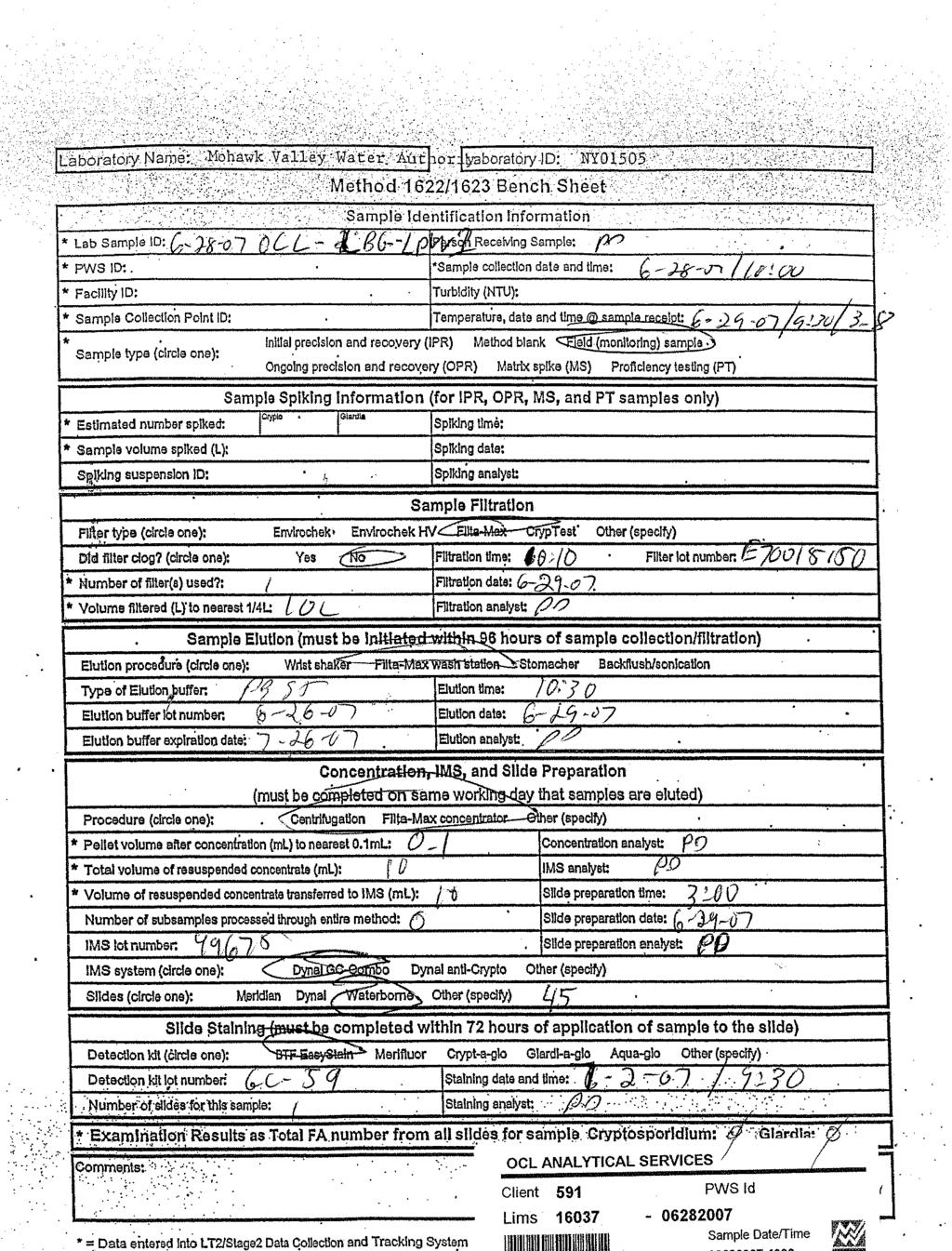
9 -6- MW-5, a sand and gravel monitoring well, located 1875 feet southeast of PW-1, showed no discernible impacts form the pumping of PW-1. TW-1, a 14-inch diameter production well located 1950 feet northwest of PW-1 shows no discernible water level drawdown due to pumping PW-1. TW-3 is a 14-inch diameter production well located 1400 feet northwest of PW-1, also showed no discernible change in the water level due to pumping from PW-1. Similarly, TW-4, a 14-inch diameter production well located 1630 feet northwest of PW-1, showed no discernible impact due to the pumping at PW-1. MW-2 is a monitoring well located 1565 feet northwest of PW-1 and the hydrograph showed no discernible impact from the pumping of PW-1. Long-Term Yield of PW-1 The specific capacity of the PW-1 after 27-hour of pumping was 11.6 gpm/ft. The maximum safe yield estimate (assuming drawdown to be five feet above the top of the screen) is 812 gpm. Therefore based on the maximum safe yield calculation, PW-1 can safely maintain a pumping rate of 250 gpm even during extended drought conditions. WATER QUALITY On June 28, 2007 at about10 hours water quality samples were collected from PW-1 and were delivered to Orange County Laboratory Analytical Services (OCL) at 11:30 hours on June 28, 2007 for all parameters required by the New York State Sanitary Code Part 5, Subpart 5-1. In addition, because PW-1 is located 60 feet from a surface-water body (Trout Brook), the analysis included microparticulate analysis (MPA) and Cryptosporadium & Giardia to determine if the well is under the direct influences of surface-water bodies. The Surface Water Treatment Rule is applied to any well under direct influence of surface-water bodies. The water-quality report will be available within two weeks of the date of this report. CONCLUSIONS Based on the result of the 27-hour pumping test conducted on PW-1, the well can sustain a yield of 250 gpm. The data indicated no discernible impact to the stream flow (stage) on Trout
10 -7- Brook. In addition, ground-water withdrawals from PW-1 during the test event indicated no discernible impacts on the existing production wells (TW-1, TW-3 and TW-4). The data indicate PW-1 can be pumped simultaneously with any of the existing production well (TW-1, TW-3 and TW-4). The hydrograph for the offsite homeowner well located at 12 Trout Brook Road indicated minor water-level interference drawdown effects of about 0.75 feet from the pumping of PW-1. The noted impacts will not impair the yield of this well. No significant offsite water-level interference effects are expected from ground-water withdrawal from PW-1 up to 250 gpm in the study region. Following completion of a larger diameter production well in the vicinity of PW-1, additional long-term testing (72-hour duration) will be conducted to confirm the yield of the well at rates equal to (250 gpm) or higher than tested for PW-1. Additional monitoring will be conducted to include onsite and offsite wells, including piezometers in Trout Brook to reaffirm above conclusions related to potential impacts. LEGGETTE, BRASHEARS & GRAHAM, INC. Reviewed by: Hillol Guha, Ph.D., P.G., P.HGW Senior Hydrogeologist/Modeler Thomas P. Cusack, CPG Principal nv August 2, 2007 H:\Legacy Ridge\WELL COMPLETION REPORT.doc
11 FIGURE


12 TW-1 TW-4 TW-3 MW-2 12 Trout Brook Road D TW-A PW-1 PZ-A Trout Brook 1 3 MW-5 D 1 2 L B G 4 Research Drive Suite 301 Shelton, Connecticut (203) O:\DWG\Legacy Ridge\2007\Fig-1.dwg, Layout1, 8/2/2007 6:46:25 PM, Acrobat PDFWriter
13 APPENDIX I
14
15
16
17 APPENDIX II
18
19
20
21
22
23
24
25 APPENDIX III
26
27
28
29
30
31
32
33 APPENDIX IV
34
35
36
37
38
39
40
41
42
43
44 LEGGETTE, BRASHEARS & GRAHAM, INC. PROFESSIONAL GROUND-WATER AND ENVIRONMENTAL ENGINEERING SERVICES RESEARCH DRIVE, SUITE 301 SHELTON, CT (203) FAX (203) August 20, 2007 Mr. Stuart E. Bassell, P.E., A.I.C.P. Senior Project Manager Lawler, Matusky & Skelly Engineers, LLP One Blue Hill Plaza P.O. Box 1509 Pearl River, NY RE: Legacy Ridge Water-Quality Results, PW-1 Woodbury, New York Dear Mr. Bassell: Attached is copy of the laboratory results for the water-quality samples (Appendix I) collected during the pumping test completed on PW-1 located on the Legacy Ridge study parcel in Woodbury, New York. As required by the New York State Department of Health (NYSDOH), the samples were analyzed for all parameters specified in the NYSDOH Sanitary Code, Part 5, Sub-part 5-1. In addition, PW-1 is located within 200 feet of a surface-water body which required the collected of a microparticulate analysis (MPA) to determine if the well is under the direct influence of surface water. The Surface Water Treatment rule is applied to any well under the direct influence of surface-water bodies. The water-quality results for PW-1 meets all New York State Drinking Water Standards. A sodium concentration of 16 mg/l (milligrams per liter) and a chloride concentration of 18 mg/l were reported for the well. Both concentrations are well below NYSDOH recommended concentration and maximum concentration levels (MCL) of 270 mg/l and 250 mg/l, respectively, for sodium and chloride. The MPA results for PW-1 reported no presence of Giardia and Cryptosporidium in the sample collected. The report also stated that no algal organisms exhibiting chlorophyll fluorescence, which area primary indicator of GWUDI (ground water under direct influence of surface water), were observed in the sample. Plant debris was noted in the sample. However, again no chlorophyll fluorescence was noted in the plant debris. These MPA results indicate that well PW-1 is at a low risk for GWUDI. CONNECTICUT OHIO ILLINOIS SOUTH DAKOTA PENNSYLVANIA FLORIDA NEW JERSEY MINNESOTA TEXAS WISCONSIN NEW YORK MISSOURI VERMONT MICHIGAN
45 Mr. Stuart E. Bassell -2- August 20, 2007 If you have any questions, please feel free to contact me at Very truly yours, LEGGETTE, BRASHEARS & GRAHAM, INC. SS:cmm Enclosures cc: M. Rosenzweig H:\Legacy Ridge\water-quality cover ltr.doc Stacy Stieber Hydrogeologist II
46
47
48
49
50
51
52
53
54
55
56
57
58
59
60
61
62
63
64
65
66
67
68
69
Silo Ridge Resort Community Addendum to Environmental Assessment Form APPENDIX I: WATER UPDATED WATER DEMAND
 Silo Ridge Resort Community Addendum to Environmental Assessment Form APPENDIX I: WATER UPDATED WATER DEMAND LEGGETTE, BRASHEARS & GRAHAM, INC. PROFESSIONAL GROUNDWATER AND ENVIRONMENTAL ENGINEERING SERVICES
REGIONAL GROUND-WATER STUDY TOWN OF WOODBURY ORANGE COUNTY, NEW YORK INTRODUCTION
 WB- INTRODUCTION The Town of 's municipal water system consists of the and the Water District (District 6), which was previously a small private system acquired by the Town in 978. EXISTING WATER SUPPLY
APPENDIX G. Aquifer Mapping & Groundwater Protection Zone
 APPENDIX G Aquifer Mapping & Groundwater Protection Zone LEGGETTE, BRASHEARS & GRAHAM, INC. PROFESSIONAL GROUNDWATER AND ENVIRONMENT AL ENGINEERING SERVICES 6 ARROW ROAD, SUITE 103 RAMSEY, NJ 07446 (20
Site Location AQUARION WATER COMPANY CANNONDALE WELL FIELD WILTON, CONNECTICUT
 Site Location PW-1 O:\DWG\Aquarion\Wilton\2018\F1_SLM.dwg, Layout1, 2/9/2018 4:18:14 PM, AcroPlotTemp2644.pc3 SOURCE: USGS TOPOGRAPHIC QUADRANGLE NORWALK NORTH, CONNECTICUT (PHOTOINSPECTED 1975). CONNECTICUT
MR. & MRS. HERBERT DAY 5595 Hartnell Road Site 7A - 5, R.R. 8 VERNON, B.C. V1T 8L6
 EVALUATION OF WATER SUPPLY FOR A PkOPOSED SUBDIVISION LOCATED NORTHWEST OF THE INTERSECTION OF HARTNELL ROAD AND DAY ROAD, AT VERNON, B.C. Prepared for MR. & MRS. HERBERT DAY 5595 Hartnell Road Site 7A
DEVELOPMENT OF AQUIFER TESTING PLANS. Brent Bauman, P.G. / Erin Lynam, Aquatic Biologist
 DEVELOPMENT OF AQUIFER TESTING PLANS Brent Bauman, P.G. / Erin Lynam, Aquatic Biologist DEVELOPMENT OF AQUIFER TESTING PLANS Goals of Aquifer Testing What questions are we trying to answer Staff review
STRAWMAN OUTLINE March 21, 2008 ISWS/ISGS REPORT ON THE OPPORTUNITIES AND CHALLENGES OF MEETING WATER DEMAND IN NORTH-EAST ILLINOIS
 STRAWMAN OUTLINE March 21, 2008 ISWS/ISGS REPORT ON THE OPPORTUNITIES AND CHALLENGES OF MEETING WATER DEMAND IN NORTH-EAST ILLINOIS REPORT TO BE DELIVERED TO THE RWSPG BY SEPTEMBER 30, 2008 Table of Contents
RIDDICK ASSOCIATES, P.C.
 RIDDICK ASSOCIATES, P.C. CIVIL & ENVIRONMENTAL ENGINEERS 139 LAFAYETTE AVENUE SUFFERN, NEW YORK 10901 845 357-7238 FAX 845 357-7267 NORMAN L. LINDSAY DENNIS G. LINDSAY ---------------------------- SEAN
Midwest Technology Assistance Center Groundwater Resource Assessment for Small Communities
 Midwest Technology Assistance Center Groundwater Resource Assessment for Small Communities Groundwater Availability At Fayette Water Company, Illinois (Fayette County) Project Overview This project is
WELLHEAD PROTECTION DELINEATION REPORT FOR THE VILLAGE OF BEAR LAKE DECEMBER 2002
 WELLHEAD PROTECTION DELINEATION REPORT FOR THE VILLAGE OF BEAR LAKE DECEMBER 2002 Prepared by: Gosling Czubak Engineering Sciences, Inc. 1280 Business Park Drive Traverse City, Michigan 48686 Telephone:
Aquifer Science Staff, January 2007
 Guidelines for Hydrogeologic Reports and Aquifer Tests Conducted Within the Jurisdictional Boundaries of the Barton Springs / Edwards Aquifer Conservation District I. Introduction Aquifer Science Staff,
REGIONAL GROUND-WATER STUDY TOWN OF CHESTER ORANGE COUNTY, NEW YORK. Prepared For. Orange County Water Authority. June 1994
 REGIONAL GROUND-WATER STUDY ORANGE COUNTY, NEW YORK Prepared For Orange County Water Authority June 994 Hudson Engineering Associates, P.C. 55 Main Street, Suite No. 3 Goshen, NY 0924 TABLE OF CONTENTS
(A)(1) A detailed statement of the nature and purpose of the existing uses.
(1) A detailed statement of the nature and purpose of the existing uses.") Wet Rock Groundwater Services, L.L.C. Groundwater Specialists TBPG Firm No: 50038 317 Ranch Road 620 South, Suite 203 Austin, Texas 78734 Ph: 512-773-3226 www.wetrockgs.com Mr. John Dupnik Barton Springs/Edwards
Wet Rock Groundwater Services, L.L.C. Groundwater Specialists TBPG Firm No: 50038 317 Ranch Road 620 South, Suite 203 Austin, Texas 78734 Ph: 512-773-3226 www.wetrockgs.com Mr. John Dupnik Barton Springs/Edwards
LAKE ARROWHEAD Hayes Township, Otsego County, Michigan. Preliminary Lake Level Augmentation Evaluation
 LAKE ARROWHEAD Hayes Township, Otsego County, Michigan Preliminary Lake Level Augmentation Evaluation LAKE ARROWHEAD PROPERTY OWNERS ASSOCIATION Gaylord, Michigan AGS Project No. 12-5020 April 12, 2012
Supplemental Guide II-Delineations
 Supplemental Guide II-Delineations Contents Source Water Protection Area Delineation... 1 Delineation Criteria for Systems Using Groundwater Sources... 2 Time of Travel... 4 Flow Boundaries... 4 Delineation
T E C H N I C A L M E M O R A N D U M
 INTERA Incorporated 9600 Great Hills Trail, Suite 300W Austin, Texas, USA 78759 512.425.2000 T E C H N I C A L M E M O R A N D U M To: From: Barton Springs/Edwards Aquifer Conservation District Wade Oliver,
Midwest Technology Assistance Center Groundwater Resource Assessment for Small Communities
 Midwest Technology Assistance Center Groundwater Resource Assessment for Small Communities Groundwater Availability At Toledo, Illinois (Cumberland County) Project Overview This project is an outgrowth
Midwest Technology Assistance Center Groundwater Resource Assessment for Small Communities
 Midwest Technology Assistance Center Groundwater Resource Assessment for Small Communities Groundwater Availability At St. Rose PWD, Illinois (Clinton County) Project Overview This project is an outgrowth
Midwest Technology Assistance Center Groundwater Resource Assessment for Small Communities
 Midwest Technology Assistance Center Groundwater Resource Assessment for Small Communities Groundwater Availability At Mechanicsburg-Buffalo Water Commission, Illinois (Sangamon County) Project Overview
Case Study A Comparison of Well Efficiency and Aquifer Test Results Louvered Screen vs. Continuous Wire-Wrapped Screen Big Pine, California
 Case Study A Comparison of Well Efficiency and Aquifer Test Results Louvered Screen vs. Continuous Wire-Wrapped Screen Big Pine, California Executive Summary Aquifer test results demonstrated that the
General Groundwater Concepts
 General Groundwater Concepts Hydrologic Cycle All water on the surface of the earth and underground are part of the hydrologic cycle (Figure 1), driven by natural processes that constantly transform water
PARKER GROUNDWATER w Technology, Innovation, Management
 Hydrogeologic Consulting in Groundwater Resources Technical Memorandum September 16, 2017 To: W.A.T.E.R. & Gateway Neighborhood Association (GNA) From: Timothy K. Parker, PG, CEG, CHG, Parker Groundwater
REGIONAL GROUND-WATER STUDY TOWN OF HAMPTONBURGH ORANGE COUNTY, NEW YORK. Prepared for. Orange County Water Authority. June 1994
 REGIOL GROUND-WATER STUDY Prepared for Orange County Water Authority June 1994 Lanc & Tully Engineering and Surveying, P.C. P.O. Box 687 - Route 207 Goshen, New York 10924 TABLE OF CONTENTS Page EXECUTIVE
Midwest Technology Assistance Center Groundwater Resource Assessment for Small Communities
 Midwest Technology Assistance Center Groundwater Resource Assessment for Small Communities Groundwater Availability At Harristown, Illinois (Macon County) Project Overview This project is an outgrowth
Illinois State Water Survey Division
 Illinois State Water Survey Division GROUND-WATER SECTION SWS Contract Report 456 SUMMARY REPORT: REGIONAL ASSESSMENT OF THE GROUND-WATER RESOURCES IN EASTERN KANKAKEE AND NORTHERN IROQUOIS COUNTIES by
Aquifer Characterization and Drought Assessment Ocheyedan River Alluvial Aquifer
 Aquifer Characterization and Drought Assessment Ocheyedan River Alluvial Aquifer Iowa Geological Survey Water Resources Investigation Report 10 Aquifer Characterization and Drought Assessment Ocheyedan
Livingston County Department of Public Health Environmental Health Division. Hydrogeologic Investigation Requirements for Land Division Developments
 Livingston County Department of Public Health Environmental Health Division Hydrogeologic Investigation Requirements for Land Division Developments Reviewed March 1, 2013 Table of Contents Scope/Authority..1
Office of Land and Water Evaluations of Groundwater Resources of Southern Mississippi
 Office of Land and Water Evaluations of Groundwater Resources of Southern Mississippi Virtually all of the water used for public and domestic drinking water supplies in southern Mississippi is derived
Midwest Technology Assistance Center Groundwater Resource Assessment for Small Communities
 Midwest Technology Assistance Center Groundwater Resource Assessment for Small Communities Groundwater Availability at Cooks Mills, Illinois (Coles County) Project Overview This project is an outgrowth
Flow-Through Lake/Wetland: Generalized Monitoring Strategy
 General Hydrologic Characteristics of Flow-Through Lakes & Wetlands Flow-through lakes are surface expressions of the water table and are in direct hydraulic connection with the water-table aquifer. They
Large-Scale Implementation of Recirculation Systems for In-Situ Treatment of Hexavalent Chromium in Groundwater in Hinkley CA 17338
 WM217 Conference, March 5 9, 217, Phoenix, Arizona, USA Large-Scale Implementation of Recirculation Systems for In-Situ Treatment of Hexavalent Chromium in Groundwater in Hinkley CA 17338 Margy Gentile
Groundwater Occurrence & Movement:
 Groundwater Occurrence & Movement: An Introductory Discussion with Application to East-Central Illinois East-Central Illinois Regional Water Supply Planning Committee July 27, 2007 Allen Wehrmann, P.E.,
Ground Water, Wells and the Summer of 1999
 Maine Geologic Facts and Localities October, 1999 Ground Water, Wells and the Summer of 1999 Text by Marc C. Loiselle, Department of Agriculture, Conservation & Forestry 1 Introduction The summer of 1999
Long-Term Variability in Methane in Domestic Water Wells in Northeast Pennsylvania
 GROUNDWATER & ENVIRONMENTAL SERVICES,INC. Charles Whisman, PE Richard Wardrop, PG Debby Yost Bert Smith, PG Long-Term Variability in Methane in Domestic Water Wells in Northeast Pennsylvania Denise Good,
REPORT ON ADDENDUM TO WELL CAPACITY TESTING REPORT SILVER STAR RESORT VERNON, BRITISH COLUMBIA. Submitted to:
 Ltd. #220-1755 Springfield Road Kelowna, British Columbia, Canada V1Y 5V5 Telephone (250) 860-8424 Fax (250) 860-9874 REPORT ON ADDENDUM TO WELL CAPACITY TESTING REPORT SILVER STAR RESORT VERNON, BRITISH
PUBLIC POLICY FORUM February 22, 2005
 SOUTHEASTERN WISCONSIN WATER SUPPLY ISSUES AND REGIONAL WATER SUPPLY PLANNING PROGRAM OVERVIEW Presentation for PUBLIC POLICY FORUM February 22, 2005 SOUTHEASTERN WISCONSIN WATER SUPPLY ISSUES AND REGIONAL
August 15, 2006 (Revised) July 3, 2006 Project No A
 July 3, 2006 Project No A") August 15, 2006 (Revised) July 3, 2006 Project No. 01-05-0854-101A Mr. David Reed, P.E. Protean Design Group 100 East Pine Street, Suite 306 Orlando, Florida 32801 Preliminary Soil Survey Report Polk Parkway
August 15, 2006 (Revised) July 3, 2006 Project No. 01-05-0854-101A Mr. David Reed, P.E. Protean Design Group 100 East Pine Street, Suite 306 Orlando, Florida 32801 Preliminary Soil Survey Report Polk Parkway
WATER QUALITY ASSESSMENT AND MICROSCOPIC PARTICULATE ANALYSIS (MPA) DATA REPORT
 DATA REPORT") Big Sky County Water & Sewer District No. 363 WATER QUALITY ASSESSMENT AND MICROSCOPIC PARTICULATE ANALYSIS (MPA) DATA REPORT LLC November 2008 , LLC 6595 Bear Claw Lane Bozeman, MT 59715 Tel (406) 585-5947
Big Sky County Water & Sewer District No. 363 WATER QUALITY ASSESSMENT AND MICROSCOPIC PARTICULATE ANALYSIS (MPA) DATA REPORT LLC November 2008 , LLC 6595 Bear Claw Lane Bozeman, MT 59715 Tel (406) 585-5947
Hydrogeology 101 3/7/2011
 Hydrogeology 101 W. Richard Laton, Ph.D., PG, CPG Associate Professor of Hydrogeology California State University, Fullerton Department of Geological Sciences 1 Hydrogeology 101 The objective is to obtain
Groundwater in Bayfield County. Madeline Gotkowitz Hydrogeologist April 23, 2015
 Groundwater in Bayfield County Madeline Gotowitz Hydrogeologist April 23, 2015 Groundwater in Bayfield County Groundwater basics Hydrogeology across Wisconsin Hydrogeology in Bayfield County Mapping groundwater
Design Checklist for EWB-USA Chapters Working on Drilled Well
 Design Checklist for EWB-USA Chapters Working on Drilled Well TAC Review for Phase 2 Borehole development and aquifer evaluation The following checklist provides a list of specific information that must
Performance Monitoring Report for September 2005
 Performance Monitoring Report for September 2005 Interim Measures Performance Monitoring Program PG&E Topock Compressor Station Needles, California Prepared for California Department of Toxic Substances
OUTLINE OF PRESENTATION
 GROUNDWATER?? OUTLINE OF PRESENTATION What is groundwater? Geologic investigation Definitions: aquifer and aquitard, unconfined and semi-confined Water level and interpretation of water level data Well
RESPONSIBLE PLANNING FOR FUTURE GROUND WATER USE FROM THE GREAT FLATS AQUIFER : TWO CASE STUDIES: THE GEP ENERGY
 RESPONSIBLE PLANNING FOR FUTURE GROUND WATER USE FROM THE GREAT FLATS AQUIFER : TWO CASE STUDIES: THE GEP ENERGY Introduction PROJECT AND THE SI GREEN FUELS BOILER PROJECT Thomas M. Johnson Hydrogeologist,
AQUIFER TEST IMPLEMENTATION BILL MILLER, P.G. SUSQUEHANNA RIVER BASIN COMMISSION
 AQUIFER TEST IMPLEMENTATION BILL MILLER, P.G. SUSQUEHANNA RIVER BASIN COMMISSION AQUIFER TEST IMPLEMENTATION Once your Aquifer Test Plan is approved Usually two years to complete the aquifer test The majority
STANDARDS AND GUIDELINES FOR MUNICIPAL WATERWORKS, WASTEWATER AND STORM DRAINAGE SYSTEMS
 STANDARDS AND GUIDELINES FOR MUNICIPAL WATERWORKS, WASTEWATER AND STORM DRAINAGE SYSTEMS January 2006 Drinking Water Branch Environmental Policy Branch Environmental Assurance Division Pub. No.: T/840
DEPARTMENT OF ENVIRONMENTAL RESOURCES REVIEW NOTICE
 DEPARTMENT OF ENVIRONMENTAL RESOURCES REVIEW NOTICE This report, prepared by outside consultants, has been reviewed by the Department of Environmental Resources and approved for publication. The contents
Groundwater Levels and Pumpage in the East St. Louis Area, Illinois,
 Circular 112 STATE OF ILLINOIS DEPARTMENT OF REGISTRATION AND EDUCATION Groundwater Levels and Pumpage in the East St. Louis Area, Illinois, 1967-1971 by W. H. BAKER, JR. ILLINOIS STATE WATER SURVEY URBANA
Groundwater and Aquifers The Groundwater Resources of Lost Pines GCD
 Groundwater and Aquifers The Groundwater Resources of Lost Pines GCD Andrew Donnelly Senior Hydrogeologist Daniel B. Stephens & Associates Where do Texans get their water? n More than half Texans depend
Recharge Lake/Wetland: Generalized Monitoring Strategy
 General Hydrologic Characteristics of Recharge Lakes & Wetlands The primary sources of water for recharge lakes and wetlands are direct precipitation and surface runoff. The lake stage of a recharge lake
1.0 EXISTING WATER RIGHTS
 June 14, 2017 Ms. Jennifer Sherman MidFirst Bank 101 Cook St Denver, Colorado 80206 Re: Review of the Hunt Estate East Ranch Groundwater Rights Dear Ms. Sherman, As requested, Deere & Ault Consultants,
Results of Morris Bridge Sink Pumping Test Hillsborough County, Florida Final Report
 Results of Morris Bridge Sink Pumping Test Hillsborough County, Florida Final Report Hydrologic Evaluation Section Southwest Florida Water Management District January 2010 Results of Morris Bridge Sink
Montana Ground-Water Assessment Statewide Monitoring Well Network
 Montana Ground-Water Assessment Statewide Monitoring Well Network Montana Ground-Water Assessment Water-level Monitoring and Drought: January March 2004 Tom Patton - Montana Bureau of Mines and Geology
Slant Well Desalination Feedwater Supply
 Slant Well Desalination Feedwater Supply Comparison Between Dana Point Test Slant Well and CEMEX Test Slant Well CalAm 9 Oct 14 Doheny Ocean Desalination Project Dana Pt. Project Location & Layout 30 mgd
Safe Drinking Water Program. Public Water System Permitting
 Safe Drinking Water Program Public Water System Permitting NC Region DEP Regions in Susquehanna Basin PA Safe Drinking Water Program The Safe Drinking Water Program implements the 1984 Safe Drinking Water
Overview of Water Availability in Mississippi
 Overview of Water Availability in Mississippi April 6, 2016 Pat Phillips, RPG MDEQ - OLWR Mississippi s Abundant Water Resources Groundwater Surface Water Average Annual Precipitation in Mississippi Surface
WELL CAPACITY AND AQUIFER TEST, McCROSKY WS-12 WATER WELL, EAST CAT CANYON DEVELOPMENT, SANTA BARBARA, CALIFORNIA
 FUGRO CONSULTANTS, INC. WELL CAPACITY AND AQUIFER TEST, McCROSKY WS-12 WATER WELL, EAST CAT CANYON DEVELOPMENT, SANTA BARBARA, CALIFORNIA Prepared for: AERA ENERGY, LLC October 2012 Fugro Job No. 04.62120157
Michigan Department of Environmental Quality Resource Management Division Office of Oil, Gas, and Minerals
 Michigan Department of Environmental Quality Resource Management Division Office of Oil, Gas, and Minerals DEQ Mission Statement The Michigan Department of Environmental Quality promotes wise management
Where in New York are the Marcellus and Utica Shales??
 Where in New York are the Marcellus and Utica Shales?? How do they get to the gas resource and how do they get the gas out of the ground? What are the concerns about this entire process and what can/should
WATER SUPPLY ISSUES IN SOUTHEASTERN WISCONSIN: TECHNICAL AND POLICY NEEDS AND CHALLENGES
 WATER SUPPLY ISSUES IN SOUTHEASTERN WISCONSIN: TECHNICAL AND POLICY NEEDS AND CHALLENGES Presentation for Conference STRADDLING THE DIVIDE WATER SUPPLY PLANNING IN THE LAKE MICHIGAN REGION February 15-16,
May 3, Kimberly D. Bose, Secretary Federal Energy Regulatory Commission 888 First Street NE, Room 1A Washington, D.C
 1250 West Century Avenue Mailing Address: P.O. Box 5601 Bismarck, ND 58506-5601 (701) 530-1600 May 3, 2018 Kimberly D. Bose, Secretary Federal Energy Regulatory Commission 888 First Street NE, Room 1A
Groundwater Monitoring System Certification
 Groundwater Monitoring System Certification for Compliance with the Coal Combustion Residuals (CCR) Rule Xcel Energy July 21, 2016, Denver, Colorado Table of Contents 1.0 Introduction... 1 2.0 Facility
NOTE ON WELL SITING AT CORNER OF CASTLE VALLEY DRIVE AND SHAFER LANE FOR TOWN OF CASTLE VALLEY, GRAND COUNTY, UTAH
 NOTE ON WELL SITING AT CORNER OF CASTLE VALLEY DRIVE AND SHAFER LANE FOR TOWN OF CASTLE VALLEY, GRAND COUNTY, UTAH Authors: Dr. Kenneth E. Kolm, Hydrologic Systems Analysis, LLC., Golden, Colorado and
31 January 2019 VIA
 31 January 2019 VIA Email: mike.conklin@wiltonct.org Michael Conklin Director of Environmental Affairs Town of Wilton Town Hall Annex 238 Danbury Road Wilton, Connecticut, 06897 RE: Review of the Aquarion
Water Framework Directive. Groundwater Monitoring Programme. Site Information. Athlacca
 Water Framework Directive Groundwater Monitoring Programme Site Information Athlacca ImagePath1: Athlacca\Athlacca 1_(800_x_600).jpg Athlacca PWS is situated in a Regional Fissured (Rf) Aquifer. The source
Rudd Westside Winery Pump Test and Well Interference Analysis 4603 Westside Road, Healdsburg
 Rudd Westside Winery Pump Test and Well Interference Analysis 4603 Westside Road, Healdsburg APN 110-110-026 PRMD File Number 14-0031 Submitted to: Misti Harris, Project Planner Sonoma County Permit and
Whitegate PWS (Dower Spring)
") Water Framework Directive Groundwater Monitoring Programme Site Information Whitegate PWS (Dower ) ImagePath1: Whitegate PWS (Dower )\04-026 (b)_(800_x_600).jpg Whitegate PWS (Dower ) is a spring used
Water Framework Directive Groundwater Monitoring Programme Site Information Whitegate PWS (Dower ) ImagePath1: Whitegate PWS (Dower )\04-026 (b)_(800_x_600).jpg Whitegate PWS (Dower ) is a spring used
Groundwater Quality and Management
 Groundwater Quality and Management Dutchess County Planning Federation April 29, 2010 Dutchess County Department of Planning & Development Russell Urban-Mead, CPG, LEED AP The Chazen Companies Course Outline
ITS GEOLOGY AND HYDROLOGY
 ITS GEOLOGY AND HYDROLOGY The Black River the Origin of its Name?? Likely the tannic-acid color derived from the forested and wetland areas in the Adirondack Mountains create the dark color of the water
Hydrologic Basis for SLVWD Drought Management Plan presented to SLVWD Board of Directors March 6, 2014
 Hydrologic Basis for SLVWD Drought Management Plan presented to SLVWD Board of Directors March 6, 2014 by Nicholas M. Johnson, Ph.D., P.G., C.Hg. Principal Hydrogeologist, MWH SLVWD Service Areas SLVWD
groundwater/surface-water interactions Evan Christianson, PG Barr Engineering Company
 groundwater/surface-water interactions Evan Christianson, PG Barr Engineering Company Discussion of. Groundwater/Surface-Water Interactions Groundwater Recharge Impacts from Pumping Potential effect on
2018 Annual Groundwater Monitoring and Corrective Action Report. Pleasant Prairie Power Plant Ash Landfill Pleasant Prairie, Wisconsin.
 2018 Annual Groundwater Monitoring and Corrective Action Report Pleasant Prairie Power Plant Ash Landfill Pleasant Prairie, Wisconsin We Energies January 31, 2019 2018 ANNUAL GROUNDWATER MONITORING AND
MEMORANDUM. Notice of Designation of a Special Well Construction Area in the City of Long Prairie, Todd County, Minnesota
 Protecting, maintaining and improving the health of all Minnesotans DATE: MEMORANDUM TO: FROM: SUBJECT: Licensed and Registered Well Contractors John Linc Stine, Director Environmental Health Division
Highlights of Study Results
 Report of Findings Test Well Construction and Aquifer Testing of the Electro Purification Wells: Hays County, Texas Highlights of Study Results For: Electro Purification, LLC 4605 Post Oak Place Houston,
Water Framework Directive. Groundwater Monitoring Programme. Site Information. Fermoy PWS
 Water Framework Directive Groundwater Monitoring Programme Site Information Fermoy PWS ImagePath1: Fermoy PWS\IE_SW_G_037_04_015_1.j pg Fermoy PWS is an infiltration gallery and a borehole with an abstraction
4 DETERMINATION OF WELLHEAD PROTECTION AREAS
 4 DETERMINATION OF WELLHEAD PROTECTION AREAS A wellhead protection area is defined as the surface and subsurface area surrounding a well, wellfield or spring that supplies a public water supply through
global distribution of water!
 groundwater! hydrologic cycle! 2 global distribution of water! Source Volume Percent Ocean 97.2000 Glaciers and other ice 2.1500 Ground Water 0.6100 Lakes fresh 0.0090 saline 0.0080 Soil Moisture 0.0050
Prepared For: Town of Castle Valley, Utah
 HYDROLOGIC ASSESSMENT OF THE SURFACE WATER AND GROUNDWATER RESOURCES OF CASTLE VALLEY, UTAH: PART 2: HESA-BASED SITING OF CULINERY WELL FOR TOWN OF CASTLE VALLEY Authors: Dr. Kenneth E. Kolm, Hydrologic
Aquifer Storage and Recovery Challenges and Solutions Frederick Bloetscher, Ph.D., P.E. Florida Atlantic University
 Aquifer Storage and Recovery Challenges and Solutions Frederick Bloetscher, Ph.D., P.E. Florida Atlantic University Why Pursue ASR? Store water for Future Raw water Potable water Irrigation Fire/other
Environmental Impact Assessment Registration Groundwater Exploration Program Communauté rurale de Kedgwick, New Brunswick
 Environmental Impact Assessment Registration Groundwater Exploration Program Communauté rurale de Kedgwick, New Brunswick Communauté rurale de Kedgwick 466 Hodgson Road Fredericton New Brunswick E3C 2G5
Numerical Modeling of Groundwater Flow in the Navajo Sandstone Aquifer at the Tuba City, Arizona, Disposal Site 15167
 Numerical Modeling of Groundwater Flow in the Navajo Sandstone Aquifer at the Tuba City, Arizona, Disposal Site 15167 ABSTRACT Richard Bush*, Timothy Bartlett** *US DOE, Office of Legacy Management **Stoller
Draft. Scope of Work. Task 1 RCRA Facility Investigation and Corrective Measures Study
 Draft Scope of Work Task 1 RCRA Facility Investigation and Corrective Measures Study DRAFT Table of Contents Task 1 RCRA Facility Investigation and Corrective Measures Study... 2 Scope of Work:... 2 Technical
APPENDIX 5: SAMPLE MODEL RESULTS
 APPENDIX 5: SAMPLE MODEL RESULTS A. Evaluation of Groundwater Sustainability in the Ramsey Area B. Evaluation of Groundwater Sustainability in the Woodbury Area C. Evaluation of Future Drawdown Conditions
Groundwater Master Plan Update: Emergency Groundwater Supply Analysis & Water Quality Discussion
 Groundwater Master Plan Update: Emergency Groundwater Supply Analysis & Water Quality Discussion BPU Study Session October 4, 2012 Presentation Outline Groundwater Quality Discussion Basin Overview Groundwater
FAX
 21335 Signal Hill Plaza Suite 100 Sterling, Virginia 20164 www.geotransinc.com 703-444-7000 FAX 703-444-1685 Mr. William Kutash Florida Department of Environmental Protection Waste Management Division
P Temporary piezometer. MW Piezometer to remain in place. P Temporary piezometer
 2. Field Program 2.1 Health and Safety Plan Prior to beginning the field program, CH2M HILL developed a health and safety plan (H&SP). The H&SP provided a summary of potential physical hazards that could
MEMORANDUM. FROM: Jordan Kear, P.G., C.Hg. KG
 MEMORANDUM TO: Mr. Robert Elliott Little Baldy Water Company PO Box 313 Llano, California 93544 FROM: Jordan Kear, P.G., C.Hg. KG12-0100 DATE: July 20, 2012 SUBJECT: Reconnaissance Level Hydrogeologic
Irrigation. Branch. Groundwater Quality in the Battersea Drainage Basin
 AGRICULTURE, FOOD AND RURAL DEVELOPMENT Irrigation Branch Groundwater Quality in the Battersea Drainage Basin Groundwater quality in the Battersea drainage basin was monitored between 1995 and 21 to characterize
Glanworth PWS (Dunmahon BH)
") Water Framework Directive Groundwater Monitoring Programme Site Information Glanworth PWS (Dunmahon BH) ImagePath1: Glanworth PWS (Dunmahon BH)\IE_SW_G_025_04_016_A_( 800_x_600).jpg Glanworth PWS (Dunmahon
Water Framework Directive Groundwater Monitoring Programme Site Information Glanworth PWS (Dunmahon BH) ImagePath1: Glanworth PWS (Dunmahon BH)\IE_SW_G_025_04_016_A_( 800_x_600).jpg Glanworth PWS (Dunmahon
MITIGATION PLAN SEAWATER INTRUSION
 MITIGATION PLAN SEAWATER INTRUSION A. OVERVIEW The Island County Health Department has identified the western area of Sections 8 and 17, Township 31 North, Range 2 East, W. M. (east of Race Road) as being
Saint Louis Water Supply Replacement Gratiot Area Water Authority
 Saint Louis Water Supply Replacement Gratiot Area Water Authority Public Forum October 23, 2013 Introduction Welcome and Introductions Format of Meeting Slide Show Presentation Question and Answer Period
Results of Blue Sink Pumping Test No. 2 Hillsborough County, Florida Final Report
 Results of Blue Sink Pumping Test No. 2 Hillsborough County, Florida Final Report Hydrologic Evaluation Section Southwest Florida Water Management District September 2009 Results of Blue Sink Pumping Test
ENVIRONMENTAL HYDROGEOLOGY
 ENVIRONMENTAL HYDROGEOLOGY m LEWIS Mostafa M. Soliman Professor, Faculty of Engineering Ain Shams University Cairo, Egypt Philip E. LaMoreaux Senior Hydrogeologist Bashir A. Memon Executive Vice President
FACT FLASH. 5: Groundwater. What is groundwater? How does the ground store water? Fact Flash 5: Groundwater
 FACT FLASH 5: Groundwater What is groundwater? Groundwater is fresh water (from rain or melting ice and snow) that soaks into the soil and is stored in the tiny spaces (pores) between rocks and particles
Calcareous Fen: Generalized Monitoring Strategy
 Calcareous Fen: Generalized Monitoring Strategy General Hydrologic Characteristics of Trout Streams Fens are wetlands fed by groundwater. Calcareous fens are wetlands fed by groundwater containing high
Tom Myers, Ph.D., Hydrogeologic Consultant Reno NV Re: Assessment of Groundwater Sampling Results Completed by the U.S.
 TECHNICAL MEMORANDUM September 30, 2012 Prepared by: Tom Myers, Ph.D., Hydrogeologic Consultant Reno NV Re: Assessment of Groundwater Sampling Results Completed by the U.S. Geological Survey Summary The
Gravity driven dewatering systems for landfill expansion
 Waste Management and the Environment IV 183 Gravity driven dewatering systems for landfill expansion S. A. Smith. & J. A. Smyth Richardson Smith Gardner and Associates, Inc, USA Abstract A landfill site
This is a digital document from the collections of the Wyoming Water Resources Data System (WRDS) Library.
 Library.") This is a digital document from the collections of the Wyoming Water Resources Data System (WRDS) Library. For additional information about this document and the document conversion process, please contact
This is a digital document from the collections of the Wyoming Water Resources Data System (WRDS) Library. For additional information about this document and the document conversion process, please contact
How Groundwater Interacts with Lakes and Streams
 How Groundwater Interacts with Lakes and Streams Ken Bradbury Wisconsin Geological and Natural History Survey University of Wisconsin-Extension AGI Critical Issues Webinar July 13, 2015 Groundwater basics
Fundamental of Groundwater Hydrology. Ted Way
 Fundamental of Groundwater Hydrology Ted Way Outline Hydrologic cycle Aquifers Basic groundwater equations Well drilling and completion Groundwater level and velocity Definition of key hydrologic parameters