PRINCESS ANNE DISTRICT STORMWATER PROJECTS
|
|
|
- George Curtis
- 6 years ago
- Views:
Transcription


1 PRINCESS ANNE DISTRICT STORMWATER PROJECTS Topics o o o o o Sea Level Rise and the Southern Watersheds Ashville Park Sherwood Lakes Kingston Estates Drainage Operations & Maintenance in the Southern Watersheds 1
2 SEA LEVEL RISE AND THE SOUTHERN WATERSHEDS DR. BRIAN BATTEN, DEWBERRY 2

3 3 Flood Complaints
4 City Response to Issues Virginia Beach City Council provided funding for a comprehensive sea level rise and recurrent flooding assessment and response plan in FY15 Dewberry, a national consultant firm, retained by the City to conduct study in January 2015 City awarded $850k grant from NOAA in March 2016 Collaborative effort with Stormwater Master Plan 4
5 Study Goal and Outcomes Goal: Produce information and strategies that will enable Virginia Beach to establish long-term resilience to sea level rise and associated recurrent flooding Outcomes: A full understanding of flood risk and anticipated changes over planning and infrastructure time horizons Actionable flood resilience plans that combine engineered protection measures, and/or floodplain management strategies A fine-tuned public outreach process to advance resilience initiatives 5


6 Watershed Level Plans Economic and environmental diversity require 4 distinct plans 6

7 7 Comprehensive SLR Study Approach


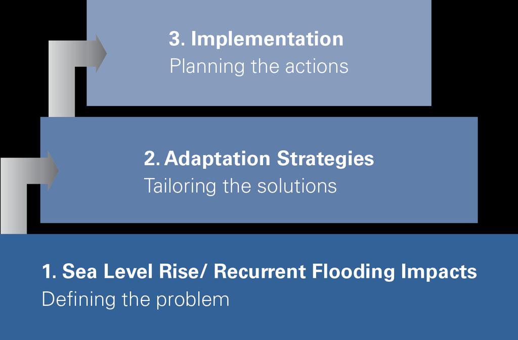
8 Phase 1: Sea Level Rise/Recurrent Flooding Impacts Objective: Identify the location, frequency and potential cost of existing and future flood risk to the City How will vulnerability change with increasing flood levels due to SLR? Where will we see the flood footprint expand? How much more frequent will flooding occur? What assets are vulnerable? What are the losses, how will they change? What assets are at the highest risk? 8


9 SLR Observations Local/Regional Trends Norfolk 9 Chesapeake Bay Duck, NC Rise in Last 50-years Location Increase, ft Sewells Point 0.8 Chesapeake Bay Bridge Tunnel 1 Duck 0.7 Oregon Inlet 0.7

10 SLR and Recurrent Flooding Image Credit: NOAA 10 Today s 1-yr water level was the 10-yr water level in the 1950s
11 VB SLR Planning Scenarios Life Cycle Alignment Time Horizon/ Time Period SLR Value Relevance Use Municipal Planning years ft Comprehensive Plan & Outcomes Short end of Commercial and Utility life-cycles Vulnerability assessment Key planning value Basis for evaluation of all adaptation strategies Critical Infrastructure Long-term awareness Adaptive Capacity years ft Utility Infrastructure life-cycle Transportation infrastructure lifecycles Residential structure lifecycles Secondary vulnerability assessment to provide insight into long-term risk Basis for long-term infrastructure decisions Evaluate cost-effectiveness of additional protection for adaptable resilience strategies 11
12 Flood Assessment Conditions Tidal Daily tidal flooding Future permanent inundation Defined by NOAA, Mean Higher High Water Nuisance Wind-driven surge, extreme tide events Repetitive losses/ loss of function or service Defined by water level analysis 12 Storm Surge Nor easters, tropical storms, hurricanes 10-, 25-, 50-, 100-, 500-yr recurrence intervals Defined by probabilistic analysis


13 Southern Watershed Issues Wind Tides Southerly winds push water into Back Bay, North Landing River Flood low-lying areas Instances since early 1900 s Ongoing area of focus Design water surface elevations in the Virginia Beach Public Works Standards and Specifications exceeds wind tide levels Credit: SeaGrant 13


14 Flood elevations - Not a static increase! SLR Integration: 1.5 ft SLR scenario Added as a static increase to surge elevations Non-linear aspects captured through re-evaluation of dune erosion and wave modeling over increased water levels. 3 ft SLR scenario Detailed modeling from USACE and North Carolina used to integrate nonlinear response in surge elevations Wave modeling and dune erosion also re-evaluated. 14

15 Projected Changes in Coastal Flooding City-wide, areas subject to flooding will increase: In years: 1.5 times In years: 2 times Changes in the Southern watershed represent 70-80% of the city-wide total 17

16 Changes in Flood Risk Southern Watershed Flood losses increase due to deeper, more frequent flooding 3-4 times increase in next 30-yrs Annualized Losses, Millions Watershed Today 1.5 SLR 3 ft SLR Southern City Total:
17 Public Engagement Capturing Perceptions, Increasing Issue Awareness Fall 2017 Interactive public sessions to solicit public opinions and perceptions on flood issues and priorities Series of public presentations to acquaint public with study process, initial results, path forward Solution Perspectives Spring 2018 Initial presentation and gathering of public feedback on flood management strategies Plan Awareness Summer/Fall 2018 Public presentation of final plans and strategy approaches/timelines 17
18 Schedule Q1 Q2 Q3 Q4 Q1 Q2 Q3 Q4 Impact Assessment Hazard Analysis and Mapping Building Risk Assessment Water Resources Analysis Infrastructure Vulnerability Strategy Development, Evaluation, Plan Formulation Lynnhaven Development Evaluation Plan Southern Elizabeth River Oceanfront Outreach Public Engagement Study Introduction, Engagement Strategy Discussion Plan Outreach 18 If additional time needed for coordination, etc.
19 ASHVILLE PARK CJ BODNAR, P.E., PW-ENGINEERING 19
20 ASHVILLE PARK ENGINEERING ANALYSIS CDM Smith performed hydraulic analyses of the Ashville Park stormwater system and developed solution alternatives. Model of stormwater system was developed using EPA Storm Water Management Model (SWMM). EPA SWMM is a complex mathematical model in widespread use across the country (gold standard). Nine months to complete, $218,000 to date 20
21 ASHVILLE PARK MODEL CALIBRATION Photos and information from the neighborhood helped provide guidance and after-the-fact water elevation data Public Works installed three water surface level gauges for data SWMM Model was calibrated using Tropical Storm Julia & Hurricane Matthew The model predicted flood water elevations that were within an inch of actual elevations for both storms 21

22 ASHVILLE PARK MODEL CALIBRATION 22

23 STUDY FINDINGS Outfall The outfall system to Flanagan s Lane and Sandbridge Road is inadequate. The rock weir cannot pass nearly enough water during a storm to keep the stormwater within the banks of the lakes The receiving ditches and channels downstream of the outfall do not have capacity to handle the stormwater, resulting in higher water elevations When water levels are high in Back Bay and Ashville Bridge Creek, even less water can pass the outfall 23
24 STUDY FINDINGS (CONTINUED) Subdivision Lakes & Stormwater Piping The stormwater piping and the lakes are inadequate There is not sufficient lake area to store runoff until it can drain through the system Higher water levels in the lakes prevent the stormwater pipes in the streets from draining quickly during and after storms Even with lowered lake elevations and more lake area, the pipe system cannot carry enough stormwater to keep the streets from flooding during significant events 24
25 ALTERNATIVES EVALUATED CDM Smith evaluated over 25 improvement scenarios and provided detailed analyses of the four most viable alternatives All 4 alternatives provide similar benefits; however, no improvement can provide complete protection from all storm events (much greater than 100-year event) All 4 alternatives require major improvements & upgrades to the neighborhood drainage system (within the streets) Alternative D is more resilient to future water levels because of the location of the proposed pump station Alternative B is more conducive to phasing and its initial phases can be implemented faster than the initial phases of Alternative D In addition to flood reduction, all alternatives provide additional stormwater quality treatment through expanded and new BMPs (wet ponds) 25
26 ASHVILLE PARK ALTERNATIVE B Hard Cost $23.5M (does not include acquisition, utility adjustments or environmental mitigation costs) 26

27 ASHVILLE PARK ALTERNATIVE D Hard Cost $21.2M (does not include acquisition, utility adjustments or environmental mitigation costs) 27
28 INTERIM IMPROVEMENTS PHASED APPROACH The FY CIP provides $9 million in funding which will allow for the first phase of Alternative B (a.k.a Scenario 5) o Considerable decrease in flooding duration o Incremental improvement in the depth of flooding o Planning level opinion of cost is $8.2 million The neighborhood and the developer both indicate a desire to continue with the development as long as there are no adverse impacts to the stormwater system in the existing villages Public Works Engineering has begun the preliminary engineering design of the Scenario 5 improvements 28
29 SCENARIO 5 IMPROVEMENTS 29
30 POSSIBLE VILLAGE C COST-PARTICIPATION Scenario 5 improvements assume Village C will be developed HomeFed is interested in proceeding with Village C and costparticipating in Scenario 5 Cost-participation based upon additional cost of the phased approach Cost share is $5.8M (71%) City, $2.4M (29%) HomeFed for initial phase (Alt. B, Scenario 5) HomeFed to cost participate up to $2.1M in future phases if Villages D & E proceed 30
31 ASHVILLE PARK INTERIM PROJECTS Dedicated 13 CFS portable pump to lower the 15-lake system prior to significant storm events (3 rain or greater) New weir and portable pump site will be constructed at existing outfall location to allow more discharge from the lake system and also prevent high water backflow into the system Weir construction scheduled for January

32 ASHVILLE PARK INTERIM PROJECT 32
33 SHERWOOD LAKES MIKE MUNDY, P.E., PW-ENGINEERING 33
 364 ac Lake Surface Area (SA) 123 ac")
34 Sherwood Lakes Sherwood Lakes Lake Drainage Area (DA) 364 ac Lake Surface Area (SA) 123 ac 34

35 Sherwood Lakes Temporary Pumping North Lake 35

36 Sherwood Lakes 1. Pump Station (5 CFS) with additional connection for temporary pump and generator Permanent Pump Station Locations 2. Intake pipe for pump station 3. Discharge Pipe from pump station 4. New storm sewer pipe (to provide some interconnection between the two ponds) 36
37 KINGSTON ESTATES (PREVIOUSLY KNOWN AS KING S LANDING) LOCATED ON WEST NECK ROAD NANCY MCINTYRE, P.E., L.S., DEVELOPMENT SERVICES ADMINISTRATOR 37

38 KINGSTON ESTATES 38

39 KINGSTON ESTATES 39
40 DRAINAGE OPERATIONS & MAINTENANCE IN THE SOUTHERN WATERSHEDS MARK JOHNSON, P.E., OPERATIONS ENGINEER 40

41 CIP PROJECTS 41
42 CIP PROJECTS Map ID Project Description Project Location Phase Stormwater Infrastructure Rehabilitation & Improvements, CIP Ashville Park Weir 1471 Flanagans Lane Design 25 Land of Promise Ditch Unit ID S8023, S8016 On Hold 27 Mill Landing Road/Halstead Shore 1301 Mill Landing Road, 1218 Mill Landing Stabilization Road Design 29 Municipal Center Drainage Infrastructure Survey Municipal Center Surveying 31 Princess Anne Road Enterprise Intersection of Princess Anne & Nimmo Parkway Construction 38 Dam Neck Road Pipe Rehabilitation Phase Dam Neck Road, London Bridge Road, Harpers II Road Design 41 Community Canal Unit ID D Study Primary System Infrastructure Improvements, CIP Mill Landing/Nanney Creek 1852 Mill Landing Road Permitting 48 Off-Road Ditch Program Zone E, K, L, & N Ditches On-Going Stormwater Pump Station Modifications, CIP Sherwood Lakes Intake Design Southern Canal / Lead Ditch and Culvert Improvements, CIP Charity Neck Road 3801 Charity Neck Road Scoping Pleasant Ridge Road 1600 Pleasant Ridge Road Scoping 42

43 OFF ROAD DITCH PROGRAM Ditch Cleaning Cycles: 16 years - Original Cycle 8 years - Goal Cycle 12 years - Current Cycle Other FY 18 Projects: Canal #2 Inspect/Repair - $300K Salem Canal Inspect/Repair - $250K West Neck Creek Inspect/Repair - $350K 43
44 STORMWATER MAINTENANCE AND INSPECTIONS Currently 124 open work orders in the Princess Anne District Roadside Ditch: 11 Cave-in: 81 Pipe Cleaning: 32 Street Sweeping - All City roads are swept 6 times per year (once every other month) MS4 Inspections Asset Inspections - 15% of known assets (pipes, structures, ditches) shall be inspected annually SWMF Inspections all City maintained SWMF inspected annually, and 20% of the privately maintained SWMF inspected annually. 44
45 END OF PRESENTATION PROCEED TO INFORMATION STATIONS 45
ASHVILLE PARK STORMWATER UPDATE
 ASHVILLE PARK STORMWATER UPDATE JULY 18, 2017 1 ASHVILLE PARK CHRONOLOGY 2005: Ashville Park conditionally rezoned. Consisted of Five Villages 2006-2007: Village A Wilshire Village was approved and construction
 ASHVILLE PARK STORMWATER UPDATE JULY 18, 2017 1 ASHVILLE PARK CHRONOLOGY 2005: Ashville Park conditionally rezoned. Consisted of Five Villages 2006-2007: Village A Wilshire Village was approved and construction
PROPOSED FY STORMWATER CIP CITY COUNCIL BRIEFING MARCH 13, 2018
 PROPOSED FY 2019-2024 STORMWATER CIP CITY COUNCIL BRIEFING MARCH 13, 2018 STORMWATER FY 2019-2024 BUDGET ISSUES Flood Control has become a critical neighborhood issue and is more complicated and expensive
PROPOSED FY STORMWATER CIP CITY COUNCIL BRIEFING MARCH 13, 2018
 PROPOSED FY 2019-2024 STORMWATER CIP CITY COUNCIL BRIEFING MARCH 13, 2018 STORMWATER FY 2019-2024 BUDGET ISSUES Flood Control has become a critical neighborhood issue and is more complicated and expensive
QUARTERLY STORMWATER UPDATE FLOOD CONTROL PROJECTS PHIL PULLEN, P.E. CITY ENGINEER DECEMBER 11, 2018
 QUARTERLY STORMWATER UPDATE FLOOD CONTROL PROJECTS PHIL PULLEN, P.E. CITY ENGINEER DECEMBER 11, 2018 D a s h b o a r d Aragona Drainage Improvements, 7-400 Ashville Park Drainage Improvements Phase I,
Sea Level Rise and Recurrent Flooding Update
 Sea Level Rise and Recurrent Flooding Update Informational Briefing City Council Meeting September 18, 2018 Thomas M. Leahy, Deputy City Manager The Sea, Inland Waters, & Groundwater are Rising Projected
QUARTERLY STORMWATER UPDATE FLOOD CONTROL PROJECTS TONI ALGER, P.E. STORMWATER ENGINEERING CENTER ADMINISTRATOR MARCH 27, 2018
 QUARTERLY STORMWATER UPDATE FLOOD CONTROL PROJECTS TONI ALGER, P.E. STORMWATER ENGINEERING CENTER ADMINISTRATOR MARCH 27, 2018 Aragona Drainage Improvements D A S H B O A R D Ashville Park Drainage Improvements
QUARTERLY STORMWATER UPDATE FLOOD CONTROL PROJECTS TONI ALGER, P.E. STORMWATER ENGINEERING CENTER ADMINSTRATOR MARCH 26, 2019
 QUARTERLY STORMWATER UPDATE FLOOD CONTROL PROJECTS TONI ALGER, P.E. STORMWATER ENGINEERING CENTER ADMINSTRATOR MARCH 26, 2019 D a s h b o a r d Aragona Drainage Improvements, 7-400 Ashville Park Drainage
QUARTERLY STORMWATER UPDATE FLOOD CONTROL PROJECTS TONI ALGER, P.E. STORMWATER ENGINEERING CENTER ADMINISTRATOR JUNE 26, 2018
 QUARTERLY STORMWATER UPDATE FLOOD CONTROL PROJECTS TONI ALGER, P.E. STORMWATER ENGINEERING CENTER ADMINISTRATOR JUNE 26, 2018 Aragona Drainage Improvements D A S H B O A R D Central Resort District Drainage
QUARTERLY STORMWATER UPDATE FLOOD CONTROL PROJECTS TONI ALGER, P.E. CITY ENGINEER S OFFICE/STORMWATER ENGINEERING CENTER DECEMBER 12, 2017
 QUARTERLY STORMWATER UPDATE FLOOD CONTROL PROJECTS TONI ALGER, P.E. CITY ENGINEER S OFFICE/STORMWATER ENGINEERING CENTER DECEMBER 12, 2017 D A S H B O A R D Aragona Drainage Improvements Ashville Park
Virginia Beach Comprehensive Sea Level Rise and Recurrent Flooding Planning Study
 1 Virginia Beach Comprehensive Sea Level Rise and Recurrent Flooding Planning Study Policy Recommendations and City-wide Flood Protection Strategies January 15, 2019 2 Agenda Project Overview Hazards and
To: From: Date: Subject: Sherwood Lakes Drainage Alternatives Analysis 1
 To: From: The City of Virginia Beach Lewis White and Rachael Johnson on behalf of WSP Date: June 6, 2017 Subject: s Drainage Alternatives Analysis This memorandum represents the summary of findings from
PROPOSED STORMWATER PROJECT IMPLEMENTATION PLAN. o Execution of New and Expanded Flood Control Projects o Program Options
 PROPOSED STORMWATER PROJECT IMPLEMENTATION PLAN o Execution of New and Expanded Flood Control Projects o Program Options PHILLIP A. DAVENPORT DIRECTOR OF PUBLIC WORKS APRIL 25, 2017 FLOOD CONTROL PROJECTS
Flooding - Tidal and Rainfall. Presentation to City Council Informal Session May 24, John M. Keifer PE
 Flooding - Tidal and Rainfall Presentation to City Council Informal Session May 24, 2011 John M. Keifer PE Purpose of Presentation 1. Review flooding causes and implications to the City 2. Discuss mitigation
FY Virginia Beach Budget Response to Council Questions
 FY 2018-2019 Virginia Beach Budget Response to Council Questions Question Number: FY19 70 Question: Building on my question number FY19 69 above, under the column heading Budgeted for FY 2019 please provide
PW/Engineering. June 20, 2013
 PW/Engineering June 20, 2013 1 Three Questions Why is the Eastern Shore Drive Drainage Area Experiencing Recurrent Flooding? What can be done about it? What is being done? Comprehensively On an Interim
Consultants, Builders and Developers Informational Meeting Stormwater Design Requirements
 Consultants, Builders and Developers Informational Meeting Stormwater Design Requirements Monday, December 4, 2017 9:00 AM 11:00 AM Public Utilities Operations Multipurpose Rooms 3500 Dam Neck Road Virginia
FY STORMWATER UPDATE TO CITY COUNCIL
 FY 2017-2022 STORMWATER UPDATE TO CITY COUNCIL MARCH 8, 2016 1 OVERVIEW Fund Summary Functional Components Closing Discussion 2 FUND SUMMARY 3 FY17 PROPOSED REVENUE ERU Daily Fee = $0.433 ERU Annual Fee
Sea Level Rise Impacts on Municipal Stormwater Systems in Hampton Roads
 VIRGINIA D.C. MARYLAND CHAPTER Sea Level Rise Impacts on Municipal Stormwater Systems in Hampton Roads Presentation at the APWA Mid-Atlantic Chapter May Regional Conference Virginia Beach, Virginia May
The newly updated and comprehensive SWMP shall:
 RFQ SCOPE OF SERVICES 2.1 Project Purpose The City of Miami, ( City ) is seeking professional engineering services from a qualified firm for the purpose of planning and developing a newly updated and comprehensive
Memorandum. Executive Summary
 277 Bendix Road Suite 300 Virginia Beach, VA 23452 Main: 757-466-1732 Fax: 757-466-1493 Memorandum To: The City of Virginia Beach From: Lewis White and Rachael Johnson on behalf of WSP Parsons Brinckerhoff
Water Quality Regulatory Programs and Our Citywide EPA / DEQ Stormwater Permit. Public Works Engineering City Council Briefing June 7, 2016
 Water Quality Regulatory s and Our Citywide EPA / DEQ Stormwater Permit Public Works Engineering City Council Briefing June 7, 2016 Briefing Topics Introduction: Regulatory Overview Elements of the MS4
COASTAL STRATEGIES FOR DRAINAGE RESILIENCE
 COASTAL STRATEGIES FOR DRAINAGE RESILIENCE FDOT S APPROACH AND VISION TODAY S TOPICS Current Concerns and Trends Risk Tolerance and Design Criteria Long-Term Coastal Planning Area of Recurring Flooding
SURREY COASTAL FLOOD ADAPTATION STRATEGY (CFAS) South Nicomekl Irrigation Meeting November 2 nd, 2016
 South Nicomekl Irrigation Meeting November 2 nd, 2016") SURREY COASTAL FLOOD ADAPTATION STRATEGY (CFAS) South Nicomekl Irrigation Meeting November 2 nd, 2016 Project What overview is it? STUDY AREA A 3 year project to help prepare Surrey for a changing climate
SURREY COASTAL FLOOD ADAPTATION STRATEGY (CFAS) South Nicomekl Irrigation Meeting November 2 nd, 2016 Project What overview is it? STUDY AREA A 3 year project to help prepare Surrey for a changing climate
Infrastructure Resiliency Planning & Strategy at the Municipal Level. Adapt, Thrive, and Survive Climate Impacts
 welcome Infrastructure Resiliency Planning & Strategy at the Municipal Level Adapt, Thrive, and Survive Climate Impacts Who we are Since 1899 Over 500 professionals 19 Office Locations on East Coast Three
Stormwater Funding Information Briefing. Mark A. Johnson, P.E.-Director of Public Works December 4, 2018
 Stormwater Funding Information Briefing Mark A. Johnson, P.E.-Director of Public Works December 4, 2018 Discussion Points History/Overview of the Stormwater Fund Stormwater Fee Debt Five Year Forecast
Water Infrastructure Resiliency Planning for the City of Norfolk. Cherryl Barnett, P.E., Engineering Manager, Department of Utilities
 Water Infrastructure Resiliency Planning for the City of Norfolk Cherryl Barnett, P.E., Engineering Manager, Department of Utilities Agenda 1. City of Norfolk Resiliency Efforts 2. Norfolk s Water System
CRYSTAL LAKE FLOODING STUDY EXECUTIVE SUMMARY
 Project #08223 CRYSTAL LAKE FLOODING STUDY EXECUTIVE SUMMARY PREPARED FOR: City of Crystal Lake 100 West Woodstock Street Crystal Lake, Illinois 60014 FEBRUARY 11, 2009 26575 W. COMMERCE DRIVE, SUITE 601,
Metropolitan St. Louis Sewer District Statement of Policy for Maintenance of Stormwater Sewer Systems
 Metropolitan St. Louis Sewer District Statement of Policy for Maintenance of Stormwater Sewer Systems 1.0 Introduction Adequate drainage in the Metropolitan St. Louis area is necessary to preserve and
New Castle County, DE. Floodplain Regulations
 New Castle County, DE Floodplain Regulations John J. Gysling, PE CFM Department of Land Use New Castle County, DE February 26, 2009 Today s Presentation Floodplain Protection and Uses Terms and Definitions
PROTECTING OUR WATERWAYS: STORMWATER POLLUTION REDUCTION EFFORTS
 PROTECTING OUR WATERWAYS: STORMWATER POLLUTION REDUCTION EFFORTS Public Information Meeting ~ May 2, 2018 Public Works Stormwater Management Division OVERVIEW Surface Water Quality Protection Municipal
Using the Brute Force Method to Push Back Flood Waters as a Result of Sea Level Rise in Miami Beach
 Using the Brute Force Method to Push Back Flood Waters as a Result of Sea Level Rise in Miami Beach Presentation to the South Florida Hydrologic Society December 3, 2014 Flooding in Miami Beach West Avenue
Introduction STORMWATER SYSTEM ENHANCEMENT RECOMMENDATIONS
 Introduction During the early morning hours on Wednesday, September 24, 2014, the City of South Daytona received over six inches of rain which caused several streets to flood. In addition, there were six
Ashville Park Stormwater Management System Flood Mitigation Plan
 CITY OF VIRGINIA BEACH Ashville Park Stormwater Management System Flood Mitigation Plan FINAL DRAFT FEBRUARY 21, 2017 Table of Contents Executive Summary... ES-1 Section 1 Introduction... 1-1 Section
RUBONIA SUBDIVISION DRAINAGE AND ROADWAY IMPROVMENTS PREPARED BY: MANATEE COUNTY PUBLIC WORKS ENGINEERING SERVICES DIVISION
 RUBONIA SUBDIVISION DRAINAGE AND ROADWAY IMPROVMENTS PREPARED BY: MANATEE COUNTY PUBLIC WORKS ENGINEERING SERVICES DIVISION OCTOBER 7, 2016 1 INTRODUCTION Rubonia Neighborhood (Rubonia) is located in northern
CITY OF NORFOLK COASTAL STORM RISK MANAGEMENT STUDY
 1 CITY OF NORFOLK COASTAL STORM RISK MANAGEMENT STUDY 255 255 255 File Name 237 237 237 217 217 217 200 200 200 0 0 0 163 163 163 131 132 122 239 65 53 80 119 27 252 174.59 110 135 120 112 92 56 62 102
TOWN LINE BROOK URBAN WATERSHED STUDY MODELING INCREMENTAL IMPROVEMENTS
 TOWN LINE BROOK URBAN WATERSHED STUDY MODELING INCREMENTAL IMPROVEMENTS Marcus M. Quigley, P.E., Project Engineer, GeoSyntec Consultants Steven P. Roy, Associate, GeoSyntec Consultants Lawrence Gil, North
Fort Collins Amendments to the Urban Drainage and Flood Control District Criteria Manual
 Fort Collins Amendments to the Urban Drainage and Flood Control District Criteria Manual Fort Collins Amendments to the Urban Drainage and Flood Control District Criteria Manual, adopted by the City Council
City of Katy Flood Protection Study (Meeting 3 of 3) October 23, 2017
 October 23, 2017") City of Katy Flood Protection Study (Meeting 3 of 3) October 23, 2017 Phasing of Meetings April Meeting May Meeting October Review of Tax Day Storm Event and Immediate Actions Taken By City Review of Coordination
City of Katy Flood Protection Study (Meeting 3 of 3) October 23, 2017 Phasing of Meetings April Meeting May Meeting October Review of Tax Day Storm Event and Immediate Actions Taken By City Review of Coordination
City of Madison: 2017 Capital Budget Capital Improvement Plan
 City of Madison: 2017 Capital Budget Capital Improvement Plan Agency: Stormwater Utility Project Summary Backyard Drainage Problems 25,000 25,000 25,000 25,000 25,000 25,000 CIPP Lining Storm Sewer 100,000
City of Virginia Beach Department of Public Works/Engineering
 City of Virginia Beach Department of Public Works/Engineering Civil & Environmental Engineering Visiting Council Spring 2010 Seminar Phil Pullen, P.E. Transportation Division May 6, 2010 1 Public Works
Adapting to Rising Tides
 Adapting to Rising Tides A regional program that uses findings, processes, tools and relationships built by ART and its partners to lead and support efforts that increase the resilience of San Francisco
Miami-Dade Water & Sewer Department. Miami-Dade Water and Sewer Department 1
 Miami-Dade Water & Sewer Department Miami-Dade Water and Sewer Department www.miamidade.gov/water 1 Miami-Dade Water and Sewer Department (WASD) Largest Water & Sewer Utility in the Southeastern United
DRAINAGE AND NATURAL AQUIFER GROUNDWATER RECHARGE ELEMENT
 Goal 7.0. To optimize integrated stormwater management in order to reduce damage and impacts from sea level rise and flooding, promotes recharge to the Surficial Aquifer System (SAS), improve and protect
CITY OF MOUNTAIN VIEW
 CITY OF MOUNTAIN VIEW Incorporate Climate Change Adaptation in Municipal Scale, Urban Watershed Planning at the City of Mountain View Raymond Wong, PhD, PE, LEED AP Lisa Au, PE Floodplain Management Association
COON CREEK WATERSHED DISTRICT PERMIT REVIEW Mississippi Dr Coon Rapids, MN SQ FT Residence on 0.64 Acre Lot
 17-082 Van Sloun Residence, Page 1 of 5 COON CREEK WATERSHED DISTRICT PERMIT REVIEW MEETING DATE: May 8, 2017 AGENDA NUMBER: 17 FILE NUMBER: 17-082 ITEM: Van Sloun Residence RECOMMENDATION: Approve with
Manhattan Levee Section 216 Feasibility Study Public Workshop 17Apr13 Manhattan Kansas
 Manhattan Levee Section 216 Feasibility Study Public Workshop 17Apr13 Manhattan Kansas Tuttle Creek Dam and Lake Kansas City District Project Development Team Manhattan, KS US Army Corps of Engineers 1
Draft Bacteria Total Maximum Daily Load Action Plan
 Draft Bacteria Total Maximum Daily Load Action Plan Public Works Department VSMP MS4 Permit # VA0088676 DRAFT June 12, 2018 Draft Bacteria Total Maximum Daily Load Action Plan (Permit VA0088676) Table
Case Study of Bridge Hurricane Vulnerability and Resilience Retrofit Planning Considering Varying Sea Level Rise Predictions
 Case Study of Bridge Hurricane Vulnerability and Resilience Retrofit Planning Considering Varying Sea Level Rise Predictions First International Conference on Surface Transportation System Resilience to
Project Summary
 Stormwater Utility Capital Improvement Plan Project Summary 2017 2018 2019 2020 2021 2022 Backyard Drainage Problems 25,000 25,000 25,000 25,000 25,000 25,000 CIPP Lining Storm Sewer 100,000 100,000 100,000
1) What is the drainage area of Chatham Hall compared to Lake James? Is the drainage area into Lake James bigger than Chatham?
 What is the drainage area of Chatham Hall compared to Lake James? Is the drainage area into Lake James bigger than Chatham?") The City of Virginia Beach received the following questions during the Chatham Hall Water Quality Improvement Project. The City continues to take action to address water quality issues related to algal
The City of Virginia Beach received the following questions during the Chatham Hall Water Quality Improvement Project. The City continues to take action to address water quality issues related to algal
Using Rapid Flood Inundation Modeling to Make Informed Decisions and Optimize Investments
 Using Rapid Flood Inundation Modeling to Make Informed Decisions and Optimize Investments Chris Niforatos, P.E. Client Account Manager chris.niforatos@ch2m.com So what is Rapid Inundation? Being able to
Village of Winnetka Flood Risk Reduction Assessment. Christopher B. Burke Engineering, Ltd. (CBBEL) October 11, 2011
 October 11, 2011") Village of Winnetka Flood Risk Reduction Assessment October 11, 2011 Christopher B. Burke Engineering, Ltd. (CBBEL) Thomas T. Burke, Jr., PhD, PE David Buckley, PE, CFM Introduction The September 2008
Village of Winnetka Flood Risk Reduction Assessment October 11, 2011 Christopher B. Burke Engineering, Ltd. (CBBEL) Thomas T. Burke, Jr., PhD, PE David Buckley, PE, CFM Introduction The September 2008
Project # Project Title Page #
 WATER UTILITY City of Virginia Beach, Virginia Fiscal Years 21-11 through 215-16 Capital Improvement Program Alphabetical Project Index Project # Project Title Page # Water Utility 5255 Automated Mobile
Guidance for Incorporating Sea Level Rise into Capital Improvement Programs. Kelli Hammer Levy, Division Director
 Guidance for Incorporating Sea Level Rise into Capital Improvement Programs Kelli Hammer Levy, Division Director Overview Local challenges Climate Science Advisory Panel (CSAP) Regional projections Guidance
NEWEA Climate Adaptation Strategies for Maine Coastal Communities WWTFs
 NEWEA Climate Adaptation Strategies for Maine Coastal Communities WWTFs Presented by: September 26, 2017 Kyle M. Coolidge, PE Introduction Introduction TR-16 GENERIC adaptation strategies Wiscasset WWTF
Engineering Department
 Engineering Department Stormwater Mission: To provide for the efficient and effective cleaning and repair of the stormwater collection system and implement the federally mandated Stormwater Pollution Prevention
Type of Problem. All existing and anticipated future problems/concerns. Building Flooding Drainage Issue Street Flooding Restrictive Structure
 Jeffersonville Stormwater Master Plan (SWMP) Advisory Committee Meeting Worksheet (1/10/12) SUMMARY OF SUGGESTED TARGET STUDY AREAS & PROMISING SOLUTIONS FOR EVALUATION IN PHASE 2 Problem Area Name 1 Existing
Regional Approaches to Resiliency
 Regional Approaches to Resiliency Addressing the Impacts of Sea Level Rise COJ Environmental Symposium September 9, 2016 Danielle H. Irwin, PWS, LEED AP Globally, the sea is expected to rise 1 4 by 2100;
5/25/2017. Lumpkin Detention Basin Houston, Texas By Brian Whitney, P.E., CFM Victor Rendon. Lumpkin Basin. Lumpkin Road Overall Description
 Lumpkin Detention Basin Houston, Texas By Brian Whitney, P.E., CFM Victor Rendon TEXAS FLOODPLAIN MANAGEMENT ASSOCIATION April 27, 2017 PROJECT LOCATION PROJECT VICINITY MAP Lumpkin Road Overall Description
COON CREEK WATERSHED DISTRICT PERMIT REVIEW. Spring Lake Park Schools Westwood Middle School st Avenue NE, Spring Lake Park, MN 55432
 PAN 16-112, Westwood Middle School, Page 1 of 6 COON CREEK WATERSHED DISTRICT PERMIT REVIEW MEETING DATE: August 22, 2016 AGENDA NUMBER: 10 FILE NUMBER: 16-112 ITEM: Westwood Middle School RECOMMENDATION:
ZONING ORDINANCE FOR THE ZONED UNINCORPORATED AREAS ARTICLE 1500 OF PUTNAM COUNTY, WEST VIRGINIA Page 149 ARTICLE 1500 DRAINAGE AND STORM SEWERS
 OF PUTNAM COUNTY, WEST VIRGINIA Page 149 ARTICLE 1500 DRAINAGE AND STORM SEWERS 1500.01 GENERAL REQUIREMENTS 1500.02 NATURE OF STORM WATER FACILITIES 1500.03 DRAINAGE EASEMENTS 1500.04 STORM WATER MANAGEMENT
Water resources planning for Broward county in response to climate change
 Water resources planning for Broward county in response to climate change Broward County Environmental Planning & Community Resilience -Samantha Danchuk, PhD, PE March 18, 2015 South Florida Hydrologic
Providence Existing Level of Service UNB Regional Stormwater Management District Feasibility Study Phase II
 Memorandum To: From: Upper Narraganset Bay Steering Committee Cynthia Baumann, P.E. Date: Subject: Providence Existing Level of Service UNB Regional Stormwater Management District Feasibility Study Phase
Stormwater Infrastructure Funding Study Public Education Session May 27, :00 9:00 pm City Hall, Multi-Purpose Room Level 100
 Stormwater Infrastructure Funding Study Public Education Session May 27, 2015 7:00 9:00 pm City Hall, Multi-Purpose Room Level 100 What is the Stormwater Infrastructure funding study? Purpose of the Stormwater
LOWER SWEETWATER CREEK
 LOWER SWEETWATER CREEK STORMWATER MANAGEMENT MASTER PLAN Prepared for the Hillsborough County Board of County Commissioners By Public Works Department/Engineering Division Stormwater Management Section
TOWN OF BRANFORD COASTAL RESILIENCE PLAN
 TOWN OF BRANFORD COASTAL RESILIENCE PLAN Presentation of the Plan Janice Plaziak, P.E., Town of Branford David Murphy, P.E., CFM, Milone & MacBroom, Inc. Scott Choquette, CFM, Dewberry Town of Branford,
12 DRAINAGE General Administrative Requirements Standards
 12 DRAINAGE 12.1 General The Design-Builder shall conduct all Work necessary to meet the requirements associated with drainage, including culverts, bridge hydraulics, roadway ditches, and closed storm
Preliminary Design Report: Prices Subdivision Drainage Improvements & Wastewater Servicing
 B.5.1 Preliminary Design Report: Prices Subdivision Drainage Improvements & Wastewater Servicing --Greenland Consulting Engineers-- 1 The Study Location (Prices Subdivision) consists of the lots fronting
PLEASE do not reuse without permission from NYCDEP. [Please notify Pinar Balci and Alan Cohn
 PLEASE do not reuse without permission from NYCDEP. [Please notify Pinar Balci (PBalci@dep.nyc.gov) and Alan Cohn (AlanC@dep.nyc.gov) if you intend to use any of these slides, and indicate where and when
Title Advanced Hydraulic Modeling to Support Emergency Action Plans
 Title Advanced Hydraulic Modeling to Support Emergency Action Plans Abstract Freese and Nichols, Inc. (FNI) developed an Emergency Action Plan (EAP) for a Levee Improvement District (LID) located in a
City of Toronto s Climate Change Adaptation Strategy to Address Urban Flooding
 City of Toronto s Climate Change Adaptation Strategy to Address Urban Flooding Michael D Andrea, M.E.Sc., P.Eng. Chief Engineer and Executive Director Engineering & Construction Services City of Toronto
Gwinnett County Stormwater System Assessment Program
 Gwinnett County Stormwater System Assessment Program Jonathan Semerjian, PE Dept. of Water Resources Stormwater Management Sam Fleming, PE Dewberry Presentation Overview Project Background Drivers Enhanced
Princess Anne Plaza and The Lakes Neighborhoods Stormwater Management System Flood Mitigation Plan
 CITY OF VIRGINIA BEACH Princess Anne Plaza and The Lakes Neighborhoods Stormwater Management System Flood Mitigation Plan FINAL APRIL 5, 2018 osemont Road Extent London Bridge Creek Windsor Woods Canal
CCSD#1 Stormwater Standards
 SECTION 5 STORMWATER MANAGEMENT PLAN This Section of the Stormwater Management Design Standards describes the methods and criteria necessary to integrate infiltration, water quality, and flow control stormwater
EXECUTIVE SUMMARY - REVISED
 EXECUTIVE SUMMARY REVISED INTRODUCTION The purpose of the Town of Salem Storm Water Management Plan is to develop recommendations and implementation strategies for addressing drainage problems and minimizing
CONSTRUCTION PLAN CHECKLIST
 CONSTRUCTION PLAN CHECKLIST The design engineer is responsible for ensuring that plans submitted for city review are in accordance with this checklist. It is requested that the executed checklist be submitted
M. Richard DeVoe. Elizabeth K. Fly, Ph.D.
 M. Richard DeVoe Executive Director Elizabeth K. Fly, Ph.D. Coastal Climate Extension Specialist Climate and Weather Weather: current state of the atmosphere (days-to-weeks) Hurricane Hugo Today s high
Prior Lake Stormwater Management & Flood Mitigation Study
 Prior Lake Stormwater Management & Flood Mitigation Study Prepared for Prior Lake-Spring Lake Watershed District and the City of Prior Lake September, 2016 4300 MarketPointe Drive, Suite 200 Minneapolis,
CITY OF LEBANON CITY WIDE DRAINAGE EVALUATION EXECUTIVE SUMMARY
 CITY OF LEBANON CITY WIDE DRAINAGE EVALUATION EXECUTIVE SUMMARY Introduction Neel-Schaffer performed an engineering evaluation of drainage issues and flooding concerns within the City of Lebanon (City)
Sea Level Rise Adaptation Strategy for San Diego Bay. Brian Holland, AICP, Climate Program Manager City of San Diego EESTF June 29, 2011
 Sea Level Rise Adaptation Strategy for San Diego Bay Brian Holland, AICP, Climate Program Manager City of San Diego EESTF June 29, 2011 Five Milestones for Climate Adaptation Adapted from Preparing for
3.3 Acceptable Downstream Conditions
 iswm TM Criteria Manual - = Not typically used or able to meet design criterion. 1 = The application and performance of proprietary commercial devices and systems must be provided by the manufacturer and
AS A COURTESY, PLEASE TURN OFF CELL PHONES AND PAGERS WHILE MEETING IS IN PROGRESS.
 Table of Contents Agenda 2 Wastewater Treatment Plant (WWTP) Hydraulic Capacity Update Staff Report 3 WWTP Capacity Outline 5 WWTP Capacity Charts 6 Drainage Concerns on Oak Hill Drive and Quail Drive
Post-Storm Infrastructure Improvements and Stream Restoration: Three Case Studies Northeastern Transportation and Wildlife Conference September 10,
 Post-Storm Infrastructure Improvements and Stream Restoration: Three Case Studies Northeastern Transportation and Wildlife Conference September 10, 2018 Today s Session: Three Case Study Examples Hurricanes,
Coastal Resilience Study. City of Lynn, MA May 31, 2016
 Coastal Resilience Study City of Lynn, MA May 31, 2016 Presenters Frank Ricciardi, P.E. Weston & Sampson Project Manager Erin Healy Anchor QEA Project Manager Robert Almy Weston & Sampson Technical Leader
NEW CLIMATE CHANGE INFORMATION FOR ENHANCING EVERGLADES RESTORATION CLIMATE PREPAREDNESS AND RESILIENCE
 NEW CLIMATE CHANGE INFORMATION FOR ENHANCING EVERGLADES RESTORATION CLIMATE PREPAREDNESS AND RESILIENCE Glenn B. Landers, P.E. USACE Jacksonville District GEER Conference, Coral Springs, FL April 19, 2017
Lower San Joaquin River Feasibility Study PLAN FORMULATION ADDENDUM
 PLAN FORMULATION ADDENDUM Non-Structural Measure Descriptions Elevate Critical Infrastructure This measure would raise at-risk critical structures above the design inundation level. Elevation would be
DRAINAGE STUDY PHASE 2 REPORT HORRY COUNTY STORMWATER DEPARTMENT HIGHWAY 9 & 57 HORRY COUNTY, SC PREPARED FOR: APRIL 07, 2016 J
 DRAINAGE STUDY PHASE 2 REPORT FOR: HIGHWAY 9 & 57 HORRY COUNTY, SC PREPARED FOR: HORRY COUNTY STORMWATER DEPARTMENT APRIL 07, 2016 Prepared by: Savannah, GA Charleston, SC Myrtle Beach, SC Brunswick, GA
CHAPTER 5. NPDES PHASE II EVALUATION
 CHAPTER 5. NPDES PHASE II EVALUATION A Stormwater Management Program for Medford was developed and submitted to the DEQ to meet requirements of the NPDES Phase II program. Phase II regulations require
Anne Arundel County Programmatic Two-Year Milestones January 2018 December 2019
 Anne Arundel County 2018 2019 Programmatic Two-Year Milestones January 2018 December 2019 (Note: New Milestones are highlighted in green) Target Urban Stormwater 12/2016 Implement the County s Watershed
Coastal Hazards Vulnerability and Fiscal Impact Study Report:
 Agenda Item B.1 Coastal Hazards Vulnerability and Fiscal Impact Study Report: Vulnerability Assessment and Adaptation Strategies Review October 12, 2015 Planning Commission Meeting Presentation by: Anne
Phase II: Proposed (regulated) Impervious in disturbed area (ac) Long Lake Existing Impervious in disturbed area (ac)
 Impervious in disturbed area (ac) Long Lake Existing Impervious in disturbed area (ac)") Permit Application No.: 17-181 Rules: Erosion Control, Wetland Protection, and Waterbody Crossings & Structures Applicant: Hennepin County Received: 4/27/17 Project: CSAH 112 Phase II Complete: 9/5/17
Permit Application No.: 17-181 Rules: Erosion Control, Wetland Protection, and Waterbody Crossings & Structures Applicant: Hennepin County Received: 4/27/17 Project: CSAH 112 Phase II Complete: 9/5/17
Presentation Overview
 Little Dry Creek Restoration Deep River Flood Risk Management Final Presentation to LCRBDC June 10, 2015 Presentation Overview Project Overview & Background Information Data Collection Model Development
Storm Surge Risk Modeling and Coastal Engineering Adaptations in a Changing Climate
 CAPE COASTAL CONFERENCE Linking Science with Local Solutions and Decision-Making Storm Surge Risk Modeling and Coastal Engineering Adaptations in a Changing Climate Kirk F. Bosma, P.E. kbosma@woodsholegroup.com
Stormwater Erosion Control & Post-Construction Plans (Stormwater Quality Plans)
") Stormwater Erosion Control & Post-Construction Plans (Stormwater Quality Plans) Allen County Stormwater Plan Submittal Checklist The following items must be provided when applying for an Allen County Stormwater
Stormwater Erosion Control & Post-Construction Plans (Stormwater Quality Plans) Allen County Stormwater Plan Submittal Checklist The following items must be provided when applying for an Allen County Stormwater
Kane County Natural Hazards Mitigation Committee
 Kane County Natural Hazards Mitigation Committee Annual Report For 2004 TO: Members of the Kane County Board FROM: Kane County Natural Hazards Mitigation Committee SUBJECT: Annual Report for 2004 Date:
Three Mile Creek (Mobile, AL) Watershed Management Plan
 Watershed Management Plan") Three Mile Creek (Mobile, AL) Watershed Management Plan Vision, Challenges and Priorities Tom Herder, Mobile Bay National Estuary Program Jerri Daniels, Dewberry The Three Mile Creek watershed drains an
Three Mile Creek (Mobile, AL) Watershed Management Plan Vision, Challenges and Priorities Tom Herder, Mobile Bay National Estuary Program Jerri Daniels, Dewberry The Three Mile Creek watershed drains an
III. INVENTORY OF EXISTING FACILITIES
 III. INVENTORY OF EXISTING FACILITIES Within the Growth Management Boundary, the existing storm drainage facilities are largely associated with development that has historically occurred in the ten drainage
Appendix A Stormwater Site Plan Report Short Form
 Appendix A Stormwater Site Plan Report Short Form The Stormwater Site Plan Report Short Form may be used for projects that trigger only Minimum Requirements #1-#5. These projects typically fall within
Coastal Management ENVIRONMENTAL QUALITY
 Joint Legislative Oversight Committee on Agriculture, Natural and Economic Resources October 8, 2018 Coastal Management ENVIRONMENTAL QUALITY NC Division of Coastal Management NC Coastal Area Management