Pennsylvania Pipeline Project
|
|
|
- Hilary Wilkinson
- 6 years ago
- Views:
Transcription

1 SUNOCO PIPELINE L.P. Pennsylvania Pipeline Project Wetland Functions and Values Assessment -Cambria County Joint Permit Application for a Pennsylvania Water Obstruction & Encroachment Permit and a U.S. Army Corps of Engineers Section 404 Permit Application Revised October 2016
2 Sunoco Pipeline, L.P. Wetland Functions and Values Assessment Pennsylvania Pipeline Project Cambria County Revised October 2016 Table of Contents 1.0 Introduction Methods Results and Impact Assessment References Attachment A EV Wetland Highway Method Function and Value Evaluation Forms Attachment B Other Wetland Highway Method Function and Value Assessments Tetra Tech, Inc. Page 2
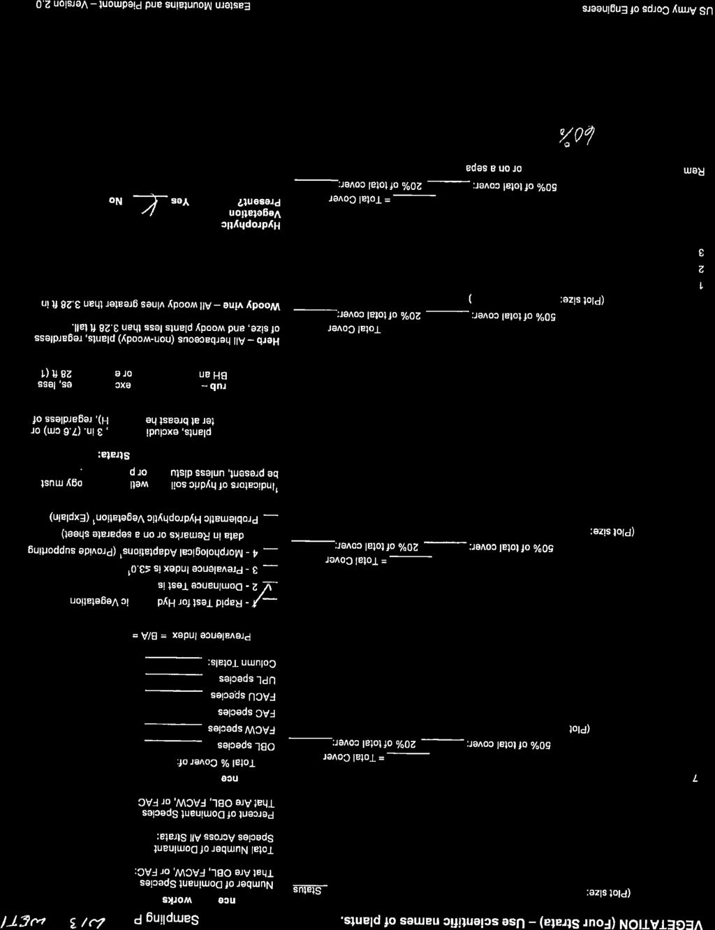
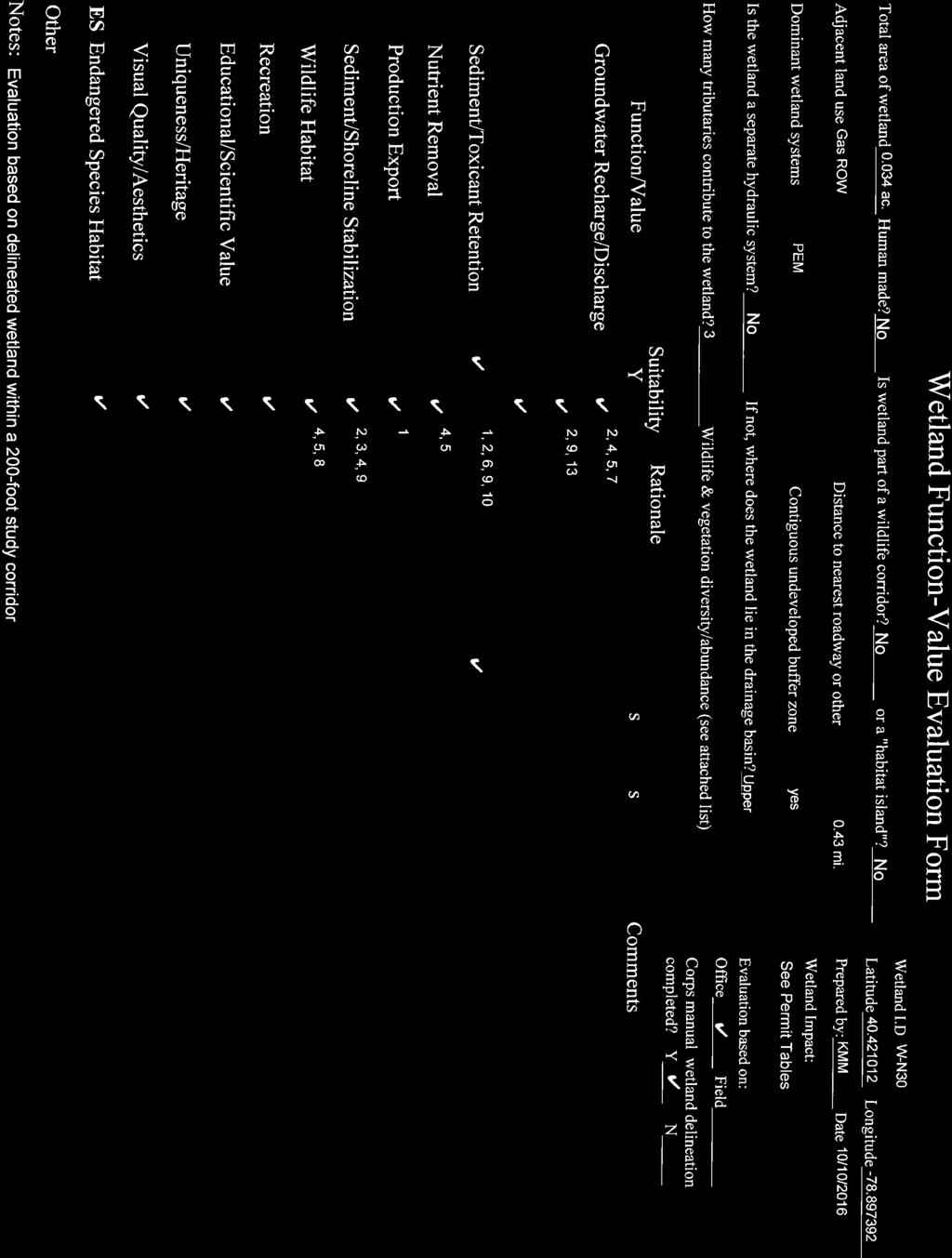
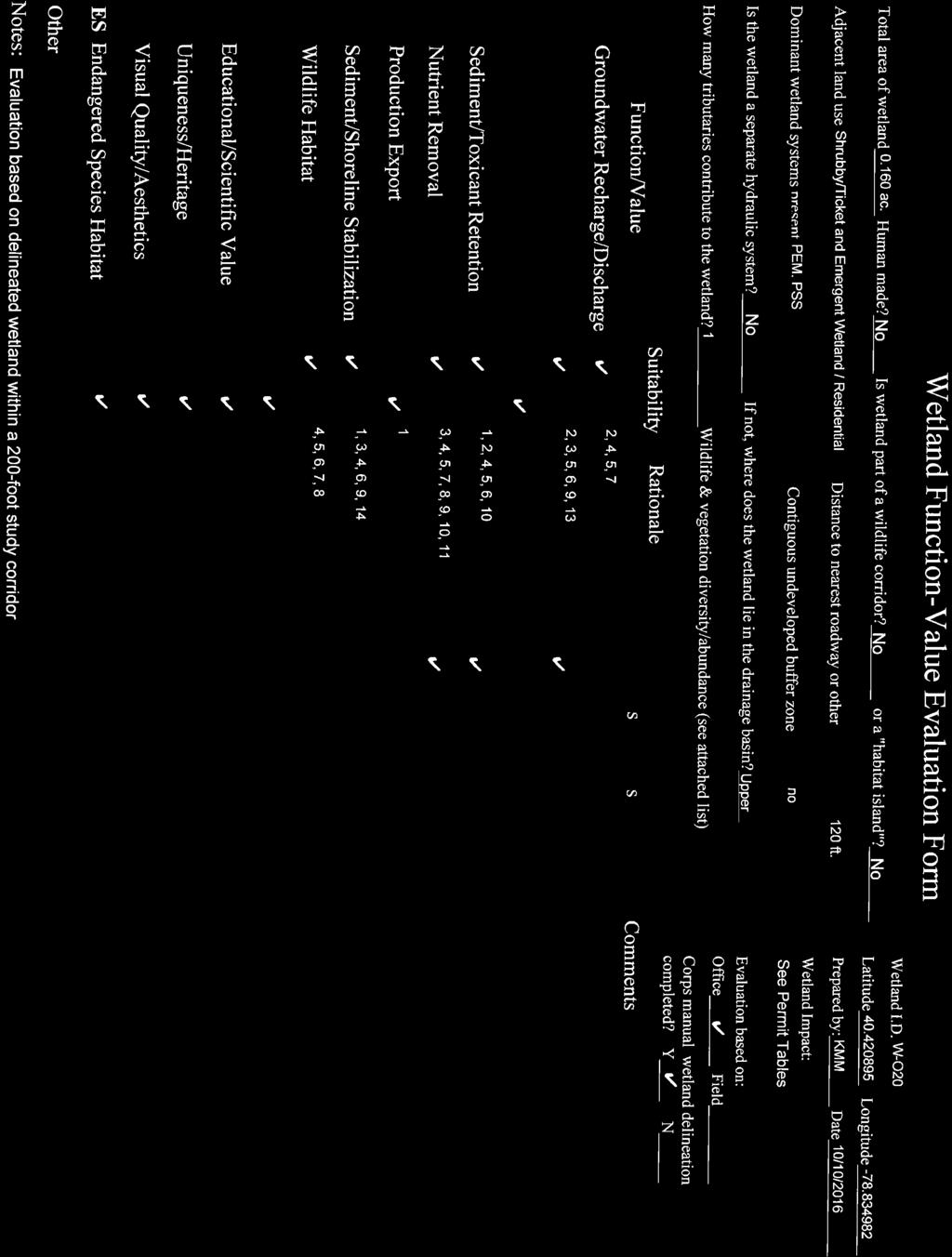
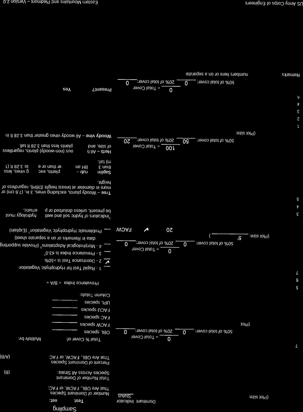
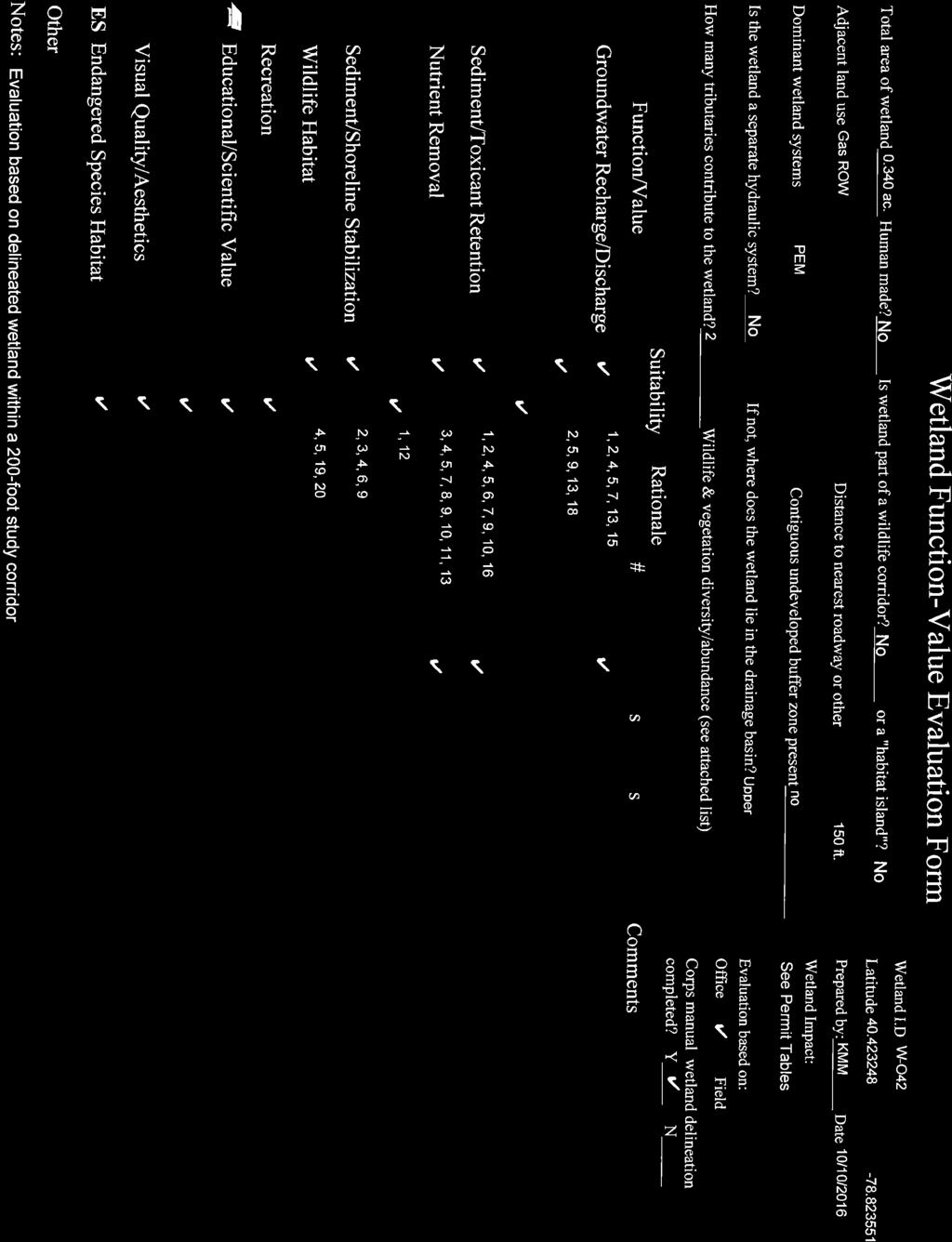
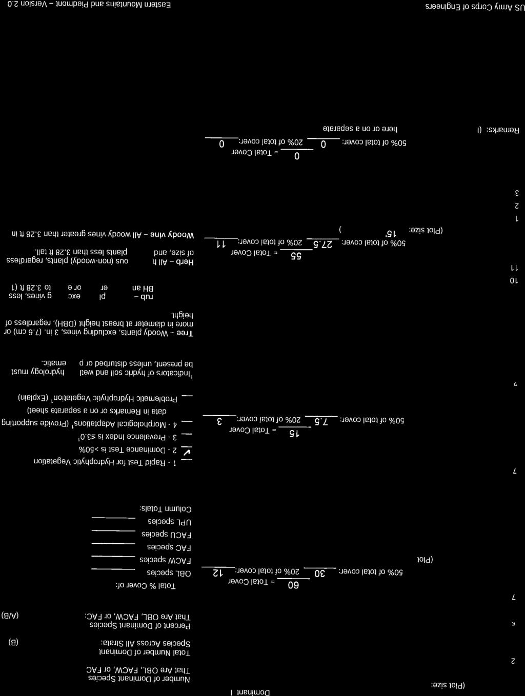
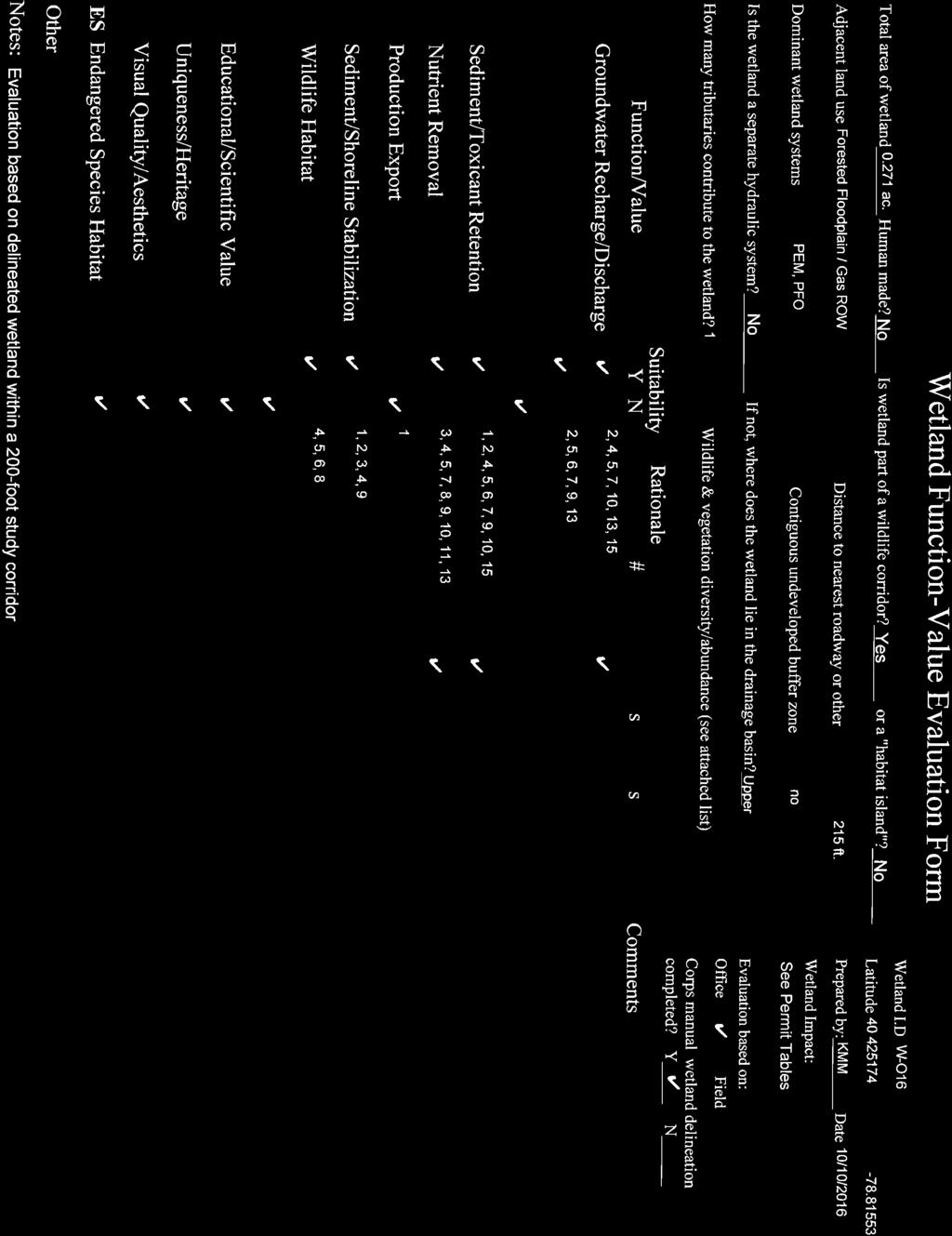
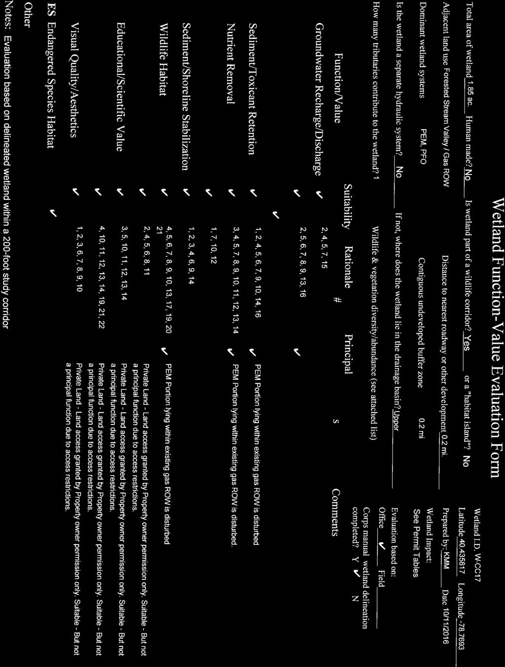
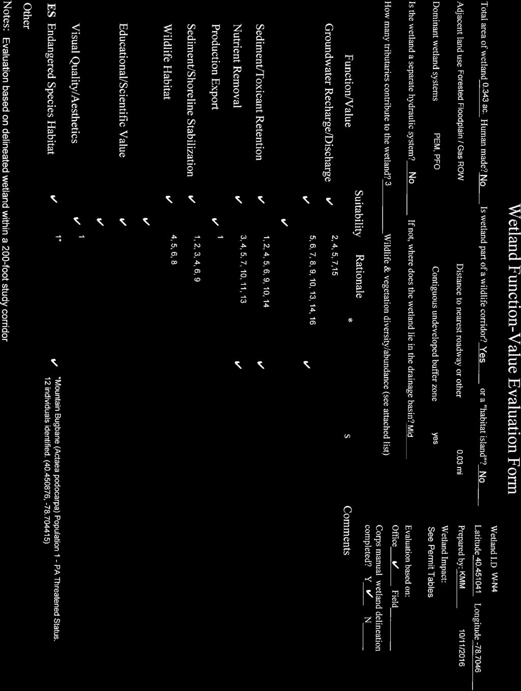
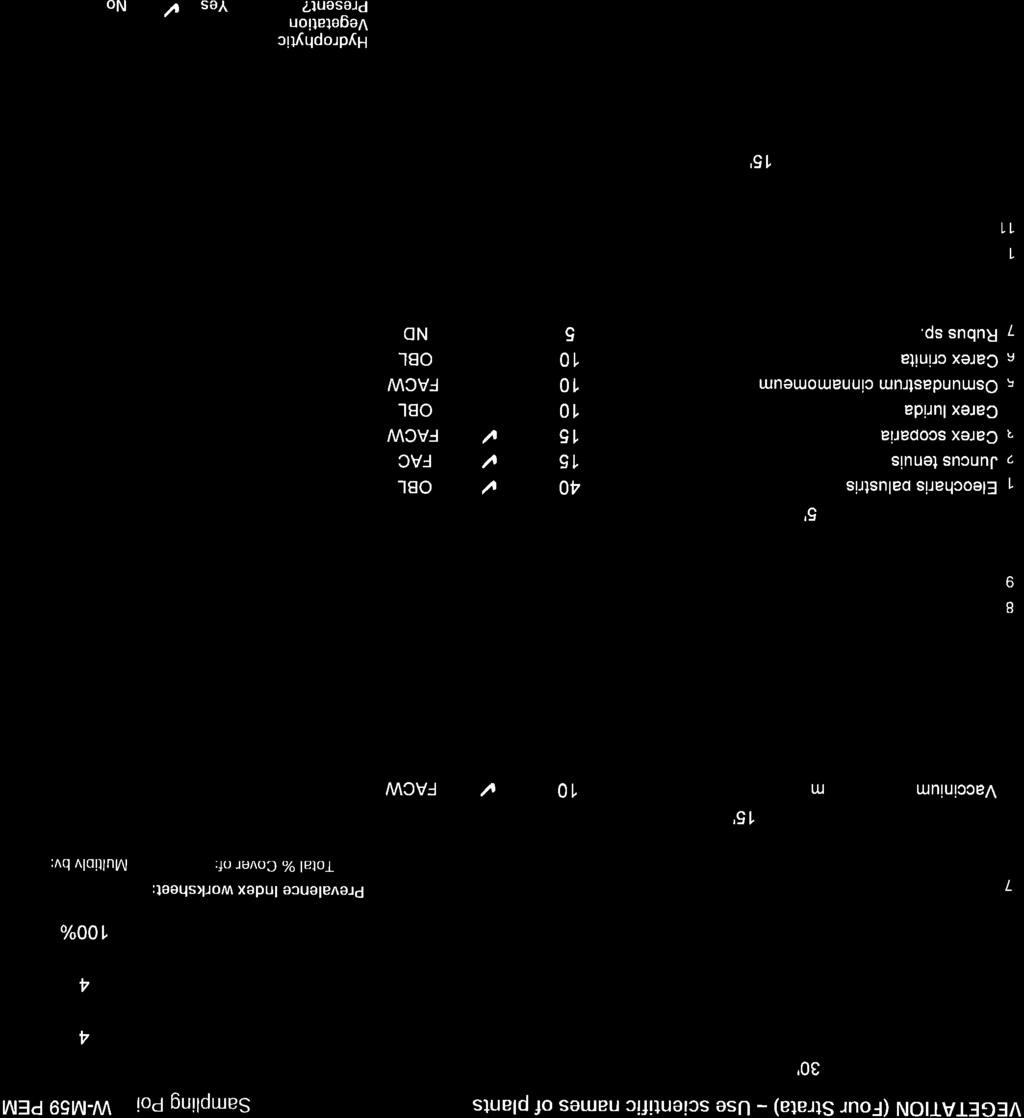
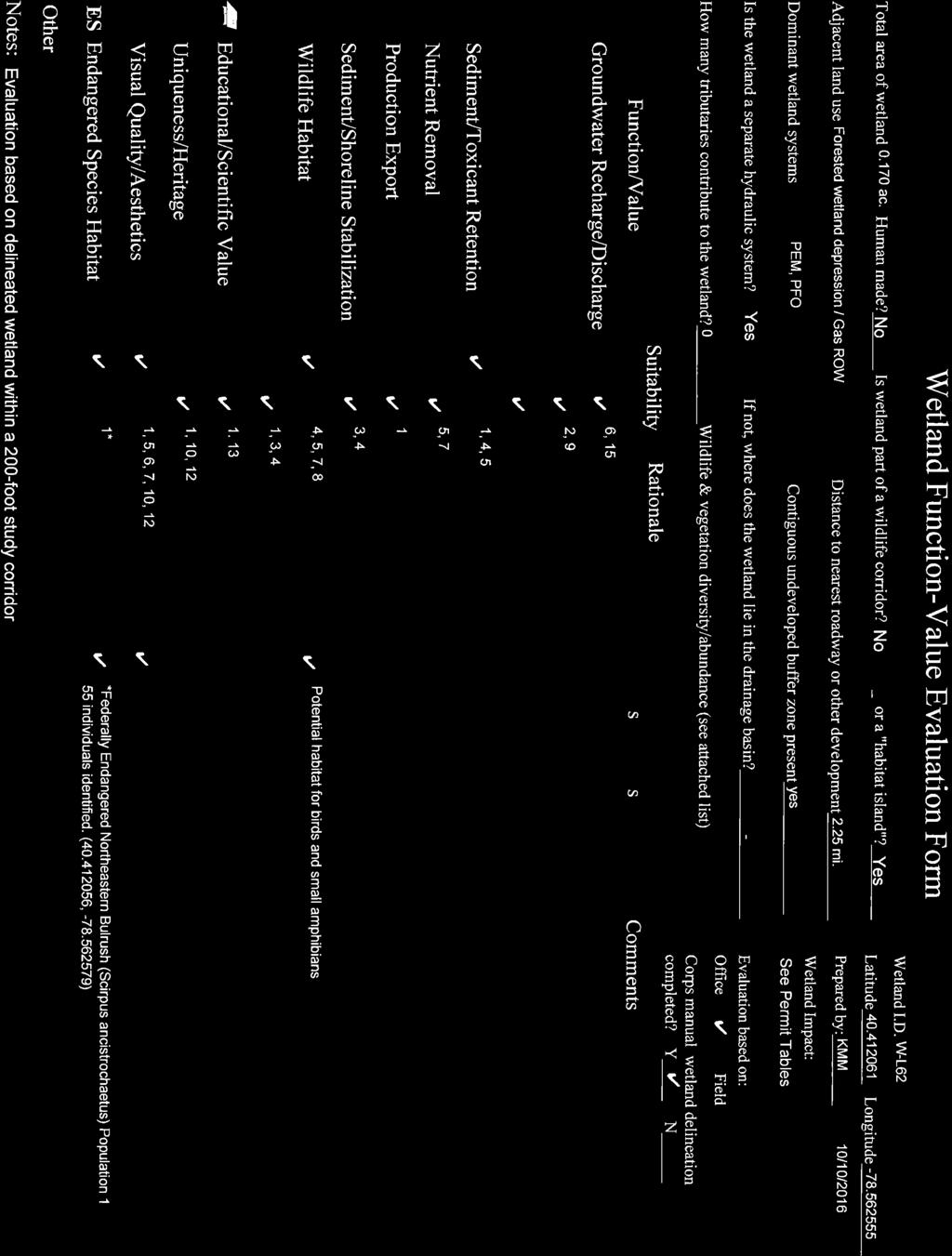
3 Sunoco Pipeline, L.P. Wetland Functions and Values Assessment Pennsylvania Pipeline Project Cambria County Revised October INTRODUCTION WETLAND FUNCTIONS AND VALUES ASSESSMENT Sunoco Pipeline s, L.P. (SPLP) is seeking Pennsylvania Department of Environmental Protection (PADEP) Chapter 105 Water Obstruction and Encroachment and U.S. Army Corps of Engineers (USACE) Section 404 permits to allow temporary impacts to aquatic resources associated with the installation and operation of the Pennsylvania Pipeline Project (Project). To support the Cambria County Joint Application, and in accordance with 25 Pa Code (e)(3), a wetland functions and values assessment is required and has been prepared for the proposed wetland impacts. The USACE Highway Methodology (USACE 1999) was chosen as the assessment method as it is generally acceptable to the PADEP and the USACE. SPLP has been diligent in siting and designing the Project to avoid and minimize adverse effects to environmental resources located along the approximately 300-mile route. As part of the application materials, an in-depth alternatives analysis is presented to demonstrate these efforts. Within that alternatives analysis it is apparent that the highest quality wetlands on the Project area being avoided through reroutes and use of horizontal directional drill (HDD) technology. Direct impacts to almost all forested wetlands, the majority of scrub-shrub wetlands, and all federally listed endangered species occupied wetlands are avoided. The remaining impacted wetlands are often small, man-made, palustrine emergent, and limited to occurring within existing rights-of-way. This functions and values assessment provides further characterization of the impacted wetlands to assist the PADEP in its evaluation of the Chapter 105 application. 2.0 METHODS As stated, the USACE Highway Methodology (USACE 1999) was chosen as the assessment method as it is generally acceptable to the PADEP and the USACE. In accordance with the method the eight functions and five values listed below were assessed for each impacted wetland. A Wetland Function-Value Evaluation Form is provided within the method s workbook and was used in the assessment of this Project s exceptional value (EV) wetlands. As first step, descriptor information on the wetland or wetland complex is provided within the header portion of the form and allows for information in respect to surround landscape as well as the impacts to be entered. As a second step, the suitability of the wetland to provide the function is assessed. Those determined to not provide the function or value or provide it at an insignificant level were considered not to be providing the function and No was checked. The rational for making the suitability decision and the considerations/qualifiers are then listed by code within the form in accordance with those listed in Table 1. Having a consideration/qualifier present did not automatically qualify the wetland as suitable for the function or value, but was a result of a combination of the presence and the evaluator s best professional judgment. Wetland delineation data sheets, pictures, topographical maps, soils maps, aerial maps, wetland and stream delineations, agency information (e.g., endangered species presence, designated exceptional value), other field survey information (e.g., threatened and endangered species), and best professional judgement were used during each evaluation. The third and final step, was to identify principle functions and values as those determined to be the most important. The objective of filling out the form is to document an unbiased record of the wetland, including Tetra Tech, Inc. Page 3
4 Sunoco Pipeline, L.P. Wetland Functions and Values Assessment Pennsylvania Pipeline Project Cambria County Revised October 2016 its location, function, appearance and relationship to its adjacent land use (USACE 1999). For nonexceptional value wetlands or other wetlands the same methodology was used but the results are presented in tabular format and lists only the principle functions provided. GROUNDWATER RECHARGE/DISCHARGE this function considers the potential for a wetland to serve as a groundwater recharge and/or discharge area. Recharge should relate to the potential for the wetland to contribute water to an aquifer. Discharge should relate to the potential for the wetland to serve as an area where groundwater can be discharged to the surface. FLOODFLOW ALTERATION (Storage & Desynchronization) This function considers the effectiveness of the wetland in reducing flood damage by attenuation of floodwaters for prolonged periods following precipitation events. FISH AND SHELLFISH HABITAT This function considers the effectiveness of seasonal or permanent waterbodies associated with the wetland in question for fish and shellfish habitat. SEDIMENT/TOICANT/PATHOGEN RETENTION This function reduces or prevents degradation of water quality. It relates to the effectiveness of the wetland as a trap for sediments, toxicants, or pathogens. NUTRIENT REMOVAL/RETENTION/TRANSFORMATION This function relates to the effectiveness of the wetland to prevent adverse effects of excess nutrients entering aquifers or surface waters such as ponds, lakes, streams, rivers, or estuaries. PRODUCTION EPORT (Nutrient) This function relates to the effectiveness of the wetland to produce food or usable products for humans or other living organisms. SEDIMENT/SHORELINE STABILIZATION This function relates to the effectiveness of a wetland to stabilize streambanks and shorelines against erosion. WILDLIFE HABITAT This function considers the effectiveness of the wetland to provide habitat for various types and populations of animals typically associated with wetlands and the wetland edge. Both resident and/ or migrating species must be considered. Species lists of observed and potential animals should be included in the wetland assessment report. RECREATION (Consumptive and Non-Consumptive) This value considers the effectiveness of the wetland and associated watercourses to provide recreational opportunities such as canoeing, boating, fishing, hunting, and other active or passive recreational activities. Consumptive activities consume or diminish the plants, animals, or other resources that are intrinsic to the wetland, whereas nonconsumptive activities do not. Tetra Tech, Inc. Page 4
5 Sunoco Pipeline, L.P. Wetland Functions and Values Assessment Pennsylvania Pipeline Project Cambria County Revised October 2016 EDUCATIONAL/SCIENTIFIC VALUE This value considers the effectiveness of the wetland as a site for an outdoor classroom or as a location for scientific study or research. UNIQUENESS/HERITAGE This value relates to the effectiveness of the wetland or its associated waterbodies to produce certain special values. Special values may include such things as archaeological sites, unusual aesthetic quality, historical events, or unique plants, animals, or geologic features. VISUAL QUALITY/AESTHETICS This value relates to the visual and aesthetic qualities of the wetland. THREATENED or ENDANGERED SPECIES HABITAT This value relates to the effectiveness of the wetland or associated waterbodies to support threatened or endangered species. Table 1 Function-Value Considerations/Qualifiers FUNCTION/VALUE Groundwater Recharge/Discharge Floodflow Alteration CONSIDERATIONS/QUALIFIERS 1. Public or private wells occur downstream of the wetland. 2. Potential exists for public or private wells downstream of the wetland. 3. Wetland is underlain by stratified drift. 4. Gravel or sandy soils present in or adjacent to the wetland. 5. Fragipan does not occur in the wetland. 6. Fragipan, impervious soils, or bedrock does occur in the wetland. 7. Wetland is associated with a perennial or intermittent watercourse. 8. Signs of groundwater recharge are present or piezometer data demonstrates recharge. 9. Wetland is associated with a watercourse but lacks a defined outlet or contains a constricted outlet. 10. Wetland contains only an outlet, no inlet. 11. Groundwater quality of stratified drift aquifer within or downstream of wetland meets drinking water standards. 12. Quality of water associated with the wetland is high. 13. Signs of groundwater discharge are present (e.g., springs). 14. Water temperature suggests it is a discharge site. 15. Wetland shows signs of variable water levels. 16. Other 1. Area of this wetland is large relative to its watershed. 2. Wetland occurs in the upper portions of its watershed. 3. Effective flood storage is small or non-existent upslope of or above the wetland. 4. Wetland watershed contains a high percent of impervious surfaces. 5. Wetland contains hydric soils which are able to absorb and detain water. 6. Wetland exists in a relatively flat area that has flood storage potential. 7. Wetland has an intermittent outlet, ponded water, or signs are present of variable water level. Tetra Tech, Inc. Page 5
6 Sunoco Pipeline, L.P. Wetland Functions and Values Assessment Pennsylvania Pipeline Project Cambria County Revised October 2016 FUNCTION/VALUE Fish and Shellfish Habitat Sediment/Toxicant/Pathogen Retention CONSIDERATIONS/QUALIFIERS 8. During flood events, this wetland can retain higher volumes of water than under normal or average rainfall conditions. 9. Wetland receives and retains overland or sheet flow runoff from surrounding uplands. 10. In the event of a large storm, this wetland may receive and detain excessive flood water from a nearby watercourse. 11. Valuable properties, structures, or resources are located in or near the floodplain downstream from the wetland. 12. The watershed has a history of economic loss due to flooding. 13. This wetland is associated with one or more watercourses. 14. This wetland watercourse is sinuous or diffuse. 15. This wetland outlet is constricted. 16. Channel flow velocity is affected by this wetland. 17. Land uses downstream are protected by this wetland. 18. This wetland contains a high density of vegetation. 19. Other 1. Forest land dominant in the watershed above this wetland. 2. Abundance of cover objects present. STOP HERE IF THIS WETLAND IS NOT ASSOCIATED WITH A WATERCOURSE 3. Size of this wetland is able to support large fish/shellfish populations. 4. Wetland is part of a larger, contiguous watercourse. 5. Wetland has sufficient size and depth in open water areas so as not to freeze solid and retain some open water during winter. 6. Stream width (bank to bank) is more than 50 feet. 7. Quality of the watercourse associated with this wetland is able to support healthy fish/shellfish populations. 8. Streamside vegetation provides shade for the watercourse. 9. Spawning areas are present (submerged vegetation or gravel beds). 10. Food is available to fish/shellfish populations within this wetland. 11. Barrier(s) to anadromous fish (such as dams, including beaver dams, waterfalls, road crossing) are absent from the stream reach associated with this wetland. 12. Evidence of fish is present. 13. Wetland is stocked with fish. 14. The watercourse is persistent. 15. Man-made streams are absent. 16. Water velocities are not too excessive for fish usage. 17. Defined stream channel is present. 18. Other 1. Potential sources of excess sediment are in the watershed above the wetland. 2. Potential or known sources of toxicants are in the watershed above the wetland. 3. Opportunity for sediment trapping by slow moving water or deepwater habitat are present in this wetland. Tetra Tech, Inc. Page 6
7 Sunoco Pipeline, L.P. Wetland Functions and Values Assessment Pennsylvania Pipeline Project Cambria County Revised October 2016 FUNCTION/VALUE Nutrient Removal/Retention/Transformation Production Export (Nutrient) CONSIDERATIONS/QUALIFIERS 4. Fine grained mineral or organic soils are present. 5. Long duration water retention time is present in this wetland. 6. Public or private water sources occur downstream. 7. The wetland edge is broad and intermittently aerobic. 8. The wetland is known to have existed for more than 50 years. 9. Drainage ditches have not been constructed in the wetland. STOP HERE IF WETLAND IS NOT ASSOCIATED WITH A WATERCOURSE. 10. Wetland is associated with an intermittent or perennial stream or a lake. 11. Channelized flows have visible velocity decreases in the wetland. 12. Effective floodwater storage in wetland is occurring. Areas of impounded open water are present. 13. No indicators of erosive forces are present. No high water velocities are present. 14. Diffuse water flows are present in the wetland. 15. Wetland has a high degree of water and vegetation interspersion. 16. Dense vegetation provides opportunity for sediment trapping and/or signs of sediment accumulation by dense vegetation is present. 17. Other 1. Wetland is large relative to the size of its watershed. 2. Deep water or open water habitat exists. 3. Overall potential for sediment trapping exists in the wetland. 4. Potential sources of excess nutrients are present in the watershed above the wetland. 5. Wetland saturated for most of the season. Ponded water is present in the wetland. 6. Deep organic/sediment deposits are present. 7. Slowly drained fine grained mineral or organic soils are present. 8. Dense vegetation is present. 9. Emergent vegetation and/or dense woody stems are dominant. 10. Opportunity for nutrient attenuation exists. 11. Vegetation diversity/abundance sufficient to utilize nutrients. STOP HERE IF WETLAND IS NOT ASSOCIATED WITH A WATERCOURSE. 12. Waterflow through this wetland is diffuse. 13. Water retention/detention time in this wetland is increased by constricted outlet or thick vegetation. 14. Water moves slowly through this wetland. 15. Other 1. Wildlife food sources grow within this wetland. 2. Detritus development is present within this wetland 3. Economically or commercially used products found in this wetland. 4. Evidence of wildlife use found within this wetland. 5. Higher trophic level consumers are utilizing this wetland. 6. Fish or shellfish develop or occur in this wetland. 7. High vegetation density is present. 8. Wetland exhibits high degree of plant community structure/species diversity. Tetra Tech, Inc. Page 7
8 Sunoco Pipeline, L.P. Wetland Functions and Values Assessment Pennsylvania Pipeline Project Cambria County Revised October 2016 FUNCTION/VALUE Sediment/Shoreline Stabilization Wildlife Habitat CONSIDERATIONS/QUALIFIERS 9. High aquatic vegetative diversity/abundance is present. 10. Nutrients exported in wetland watercourses (permanent outlet present). 11. Flushing of relatively large amounts of organic plant material occurs from this wetland. 12. Wetland contains flowering plants that are used by nectar-gathering insects. 13. Indications of export are present. 14. High production levels occurring, however, no visible signs of export (assumes export is attenuated). 15. Other 1. Indications of erosion or siltation are present. 2. Topographical gradient is present in wetland. 3. Potential sediment sources are present up-slope. 4. Potential sediment sources are present upstream. 5. No distinct shoreline or bank is evident between the waterbody and the wetland or upland. 6. A distinct step between the open waterbody or stream and the adjacent land exists (i.e., sharp bank) with dense roots throughout. 7. Wide wetland (>10 ) borders watercourse, lake, or pond. 8. High flow velocities in the wetland. 9. The watershed is of sufficient size to produce channelized flow. 10. Open water fetch is present. 11. Boating activity is present. 12. Dense vegetation is bordering watercourse, lake, or pond. 13. High percentage of energy-absorbing emergents and/or shrubs border a watercourse, lake, or pond. 14. Vegetation is comprised of large trees and shrubs that withstand major flood events or erosive incidents and stabilize the shoreline on a large scale (feet). 15. Vegetation is comprised of a dense resilient herbaceous layer that stabilizes sediments and the shoreline on a small scale (inches) during minor flood events or potentially erosive events. 16. Other 1. Wetland is not degraded by human activity. 2. Water quality of the watercourse, pond, or lake associated with this wetland meets or exceeds Class A or B standards. 3. Wetland is not fragmented by development. 4. Upland surrounding this wetland is undeveloped. 5. More than 40% of this wetland edge is bordered by upland wildlife habitat (e.g., brushland, woodland, active farmland, or idle land) at least 500 feet in width. 6. Wetland is contiguous with other wetland systems connected by a watercourse or lake. 7. Wildlife overland access to other wetlands is present. 8. Wildlife food sources are within this wetland or are nearby. 9. Wetland exhibits a high degree of interspersion of vegetation classes and/or open water. Tetra Tech, Inc. Page 8
9 Sunoco Pipeline, L.P. Wetland Functions and Values Assessment Pennsylvania Pipeline Project Cambria County Revised October 2016 FUNCTION/VALUE Recreation Education/Scientific Value CONSIDERATIONS/QUALIFIERS 10. Two or more islands or inclusions of upland within the wetland are present. 11. Dominant wetland class includes deep or shallow marsh or wooded swamp. 12. More than three acres of shallow permanent open water (less than 6.6 feet deep), including streams in or adjacent to wetland, are present. 13. Density of the wetland vegetation is high. 14. Wetland exhibits a high degree of plant species diversity. 15. Wetland exhibits a high degree of diversity in plant community structure (e.g., tree/ shrub/vine/grasses/mosses) 16. Plant/animal indicator species are present. (List species for project) 17. Animal signs observed (tracks, scats, nesting areas, etc.) 18. Seasonal uses vary for wildlife and wetland appears to support varied population diversity/abundance during different seasons. 19. Wetland contains or has potential to contain a high population of insects. 20. Wetland contains or has potential to contain large amphibian populations. 21. Wetland has a high avian utilization or it s potential. 22. Indications of less disturbance-tolerant species are present. 23. Signs of wildlife habitat enhancement are present (birdhouses, nesting boxes, food sources, 1. Wetland is part of a recreation area, park, forest, or refuge. 2. Fishing is available within or from the wetland. 3. Hunting is permitted in the wetland. 4. Hiking occurs or has potential to occur within the wetland. 5. Wetland is a valuable wildlife habitat. 6. The watercourse, pond, or lake associated with the wetland is unpolluted. 7. High visual/aesthetic quality of this potential recreation site. 8. Access to water is available at this potential recreation site for boating, canoeing, or fishing. 9. The watercourse associated with this wetland is wide and deep enough to accommodate canoeing and/or non-powered boating. 10. Off-road public parking available at the potential recreation site. 11. Accessibility and travel ease is present at this site. 12. The wetland is within a short drive or safe walk from highly populated public and private areas. 13. Other 1. Wetland contains or is known to contain threatened, rare, or endangered species. 2. Little or no disturbance is occurring in this wetland. 3. Potential educational site contains a diversity of wetland classes which are accessible or potentially accessible. 4. Potential educational site is undisturbed and natural. Tetra Tech, Inc. Page 9
10 Sunoco Pipeline, L.P. Wetland Functions and Values Assessment Pennsylvania Pipeline Project Cambria County Revised October 2016 FUNCTION/VALUE Uniqueness/Heritage CONSIDERATIONS/QUALIFIERS 5. Wetland is considered to be a valuable wildlife habitat. 6. Wetland is located within a nature preserve or wildlife management area. 7. Signs of wildlife habitat enhancement present (bird houses, nesting boxes, food sources, etc.). 8. Off-road parking at potential educational site suitable for school bus access in or near wetland. 9. Potential educational site is within safe walking distance or a short drive to schools. 10. Potential educational site is within safe walking distance to other plant communities. 11. Direct access to perennial stream at potential educational site is available. 12. Direct access to pond or lake at potential educational site is available. 13. No known safety hazards exist within the potential educational site. 14. Public access to the potential educational site is controlled. 15. Handicap accessibility is available. 16. Site is currently used for educational or scientific purposes. 17. Other 1. Upland surrounding wetland is primarily urban. 2. Upland surrounding wetland is developing rapidly. 3. More than 3 acres of shallow permanent open water (less than 6.6 feet deep), including streams, occur in wetlands. 4. Three or more wetland classes are present. 5. Deep and/or shallow marsh or wooded swamp dominate. 6. High degree of interspersion of vegetation and/or open water occur in this wetland. 7. Well-vegetated stream corridor (15 feet on each side of the stream) occurs in this wetland. 8. Potential educational site is within a short drive or a safe walk from schools. 9. Off-road parking at potential educational site is suitable for school buses. 10. No known safety hazards exist within this potential educational site. 11. Direct access to perennial stream or lake exists at potential educational site. 12. Two or more wetland classes are visible from primary viewing locations. 13. Low-growing wetlands (marshes, scrub-shrub, bogs, and open water) are visible from primary viewing locations. 14. Half an acre of open water or 200 feet of stream is visible from the primary viewing locations. 15. Large area of wetland is dominated by flowering plants or plants that turn vibrant colors in different seasons. 16. General appearance of the wetland visible from primary viewing locations is unpolluted and/or undisturbed. 17. Overall view of the wetland is available from the surrounding upland. 18. Quality of the water associated with the wetland is high. 19. Opportunities for wildlife observations are available. Tetra Tech, Inc. Page 10
11 Sunoco Pipeline, L.P. Wetland Functions and Values Assessment Pennsylvania Pipeline Project Cambria County Revised October 2016 FUNCTION/VALUE Visual Quality/Aesthetics Endangered Species Habitat CONSIDERATIONS/QUALIFIERS 20. Historical buildings are found within the wetland. 21. Presence of pond or pond site and remains of a dam occur within the wetland. 22. Wetland is within 50 yards of the nearest perennial watercourse. 23. Visible stone or earthen foundations, berms, dams, standing structures, or associated features occur within the wetland. 24. Wetland contains critical habitat for a state- or federally-listed threatened or endangered species. 25. Wetland is known to be a study site for scientific research. 26. Wetland is a natural landmark or recognized by the state natural heritage inventory authority as an exemplary natural community. 27. Wetland has local significance because it serves several functional values. 28. Wetland has local significance because it has biological, geological, or other features that are locally rare or unique. 29. Wetland is known to contain an important archaeological site. 30. Wetland is hydrologically connected to a state or federally designated scenic river. 31. Wetland is located in an area experiencing a high wetland loss rate. 32. Other 1. Multiple wetland classes are visible from primary viewing locations. 2. Emergent marsh and/or open water are visible from primary viewing locations. 3. A diversity of vegetative species is visible from primary viewing locations. 4. Wetland is dominated by flowering plants or plants that turn vibrant colors in different seasons. 5. Land use surrounding the wetland is undeveloped as seen from primary viewing locations. 6. Visible surrounding land use form contrasts with wetland. 7. Wetland views absent of trash, debris, and signs of disturbance. 8. Wetland is considered to be a valuable wildlife habitat. 9. Wetland is easily accessed. 10. Low noise level at primary viewing locations. 11. Unpleasant odors absent at primary viewing locations. 12. Relatively unobstructed sight line exists through wetland. 13. Other 1. Wetland contains or is known to contain threatened or endangered species. 2. Wetland contains critical habitat for a state or federally listed threatened or endangered species. Tetra Tech, Inc. Page 11
12 Sunoco Pipeline, L.P. Wetland Functions and Values Assessment Pennsylvania Pipeline Project Cambria County Revised October RESULTS AND IMPACT ASSESSMENT The Project crosses a total of 20 exceptional value wetlands in Cambria County. The Wetland Function- Value Evaluation Form is filled out for each of these wetlands and is located in Attachment A. For the non-exceptional value wetlands, the assessment is provided in Tabular format and is located in Attachment B. Please see the Alternative Analysis part of the application, specifically prepared in accordance with Title 25 of the Pennsylvania Code a(a), to demonstrate that the Project has avoided impacts to aquatic resources to the maximum extent practicable and has been designed to avoid significant adverse impact on wetlands, either through aerial extent or impacts on wetland function and values. The Project crosses the 20 exceptional value wetlands and 67 other wetlands in Cambria County. The wetland impacts associated with the Project are temporary, and original grades and hydrology will be restored. Wetland functions and values, including exceptional value wetlands, will not be significantly altered. Those wetlands crossed by an HDD have already implemented measures to reduce the potential for inadvertent return through design phase geotechnical study and careful drill alignment planning. No surface impact or function and value impact to these drilled wetlands is expected as a result of the Project. During drill operation an inadvertent return contingency plan will be implemented at all times to further reduce the potential for impacts to wetlands or the functions and values provided. Extra precautions are taken at each wetland to protect functions and values. Before construction begins, all Project workspaces are surveyed and marked including wetland boundaries. During construction these areas are inspected often to ensure these limits are adhered too. This ensures that only permitted wetland disturbances occur. Limiting the disturbance level to the authorized and minimum amount practicable significantly reduces the potential for unplanned impacts to functions and values. The Project will be constructed under a PADEP Chapter 102 Erosion and Sediment Control General Permit authorization. This authorization, provides for the construction sequence and requires the installation of BMPs to protect the wetland during and post-construction. The BMPs are derived directly from PADEP manuals and are designed to protect aquatic resource function and value. For example, the installation of trench breakers at wetland entry and exit points is designed to protect wetland hydrology and maintain preconstruction groundwater recharge/discharge, floodflow alteration, sediment/toxicant retention, nutrient removal, and production export when these functions are present. The erosion and control permit will also stipulate top-soil separation in non-saturated wetlands to ensure proper restoration of the native seedbank. In addition, permit authorizations will require monitoring and that monitoring will establish criteria for contour, hydrology, and vegetation restoration. This monitoring and required agency reporting will further ensure functions and values are not lost. Stream bed and banks are required to be restored to stabilized condition, and as a result, for wetlands directly abutting stream banks the sediment/shoreline stabilization function is expected to remain unchanged. Fish and shellfish habitat is often degraded as a result of undue sedimentation at Project areas or within downstream waters. The implementation of dry crossing methods at all flowing streams, reduces during construction sedimentation impacts and restoration of stream beds and banks after installation further protects adjacent wetlands and downstream waters. In addition, stream bed substrate is required to be separated and restored to protect important fish spawning habitat. Most streams will be traversed Tetra Tech, Inc. Page 12
13 Sunoco Pipeline, L.P. Wetland Functions and Values Assessment Pennsylvania Pipeline Project Cambria County Revised October 2016 (trenched and backfilled) within 24 hours to reduce exposure to Project activities and unforeseen weather events. Although many impacts are avoided and minimized, some functions and values would be temporarily affected by construction of the Project. All noted functions and values may be temporarily lost during construction as in the case of very small wetlands completely impacted by Project activities. However, these smaller wetlands often do not provide principal functions, unless an endangered species or unique/heritage value is noted. Large wetlands extending beyond the Project boundaries would still continue to provide the noted functions and values during construction as the impact area relative to the size of the wetland is minor. Several wetlands are noted as providing the wildlife habitat function. While temporary, short-term impacts may be unavoidable to non-mobile wildlife occupying these wetlands, the wetland will be restored and re-occupation is expected by the general wildlife community. More mobile species are expected to occupy adjacent habitats and all sensitive species occupied wetlands have been avoided through re-routes or Project design (e.g., HDD). In summary, the exceptional value and other wetlands impacted provide functions and values at varying levels. SPLP has taken great steps to avoid and minimize wetland impacts across Cambria County. Permanent and temporary wetland impacts are based on PADEP definitions. Permanent impacts are those areas affected by a water obstruction or encroachment that consist of both direct and indirect impacts that result from the placement or construction of a water obstruction or encroachment and include areas necessary for the operation and maintenance of the water obstruction or encroachment located in, along or across, or projecting into the floodway. Although PADEP defines operation and maintenance activities as permanent impacts, all wetlands affected by the Project will be restored to pre-construction conditions including the presence of wetland soils, hydrology, and hydrophytic vegetation. In addition, the Project does not involve any permanent fill and there will be no permanent loss of wetland area associated with the Project. SPLP will not maintain the ROW through wetland areas (i.e., no mowing); therefore, the preand post-construction conditions of the wetland areas will be the same, except for a nominal areal extent of forested wetland that will be converted to emergent wetland. Temporary impacts are those areas affected during the construction of a water obstruction or encroachment that consists of both direct and indirect impacts located in, along or across, or projecting into a watercourse, floodway or body of water that are restored upon completion of construction. This does not include areas that will be maintained as a result of the operation and maintenance of the water obstruction or encroachment located in, along or across, or projecting into the floodway. Given the PADEP permanent and temporary impact definitions, Permanent ROW impacts total acres and temporary impacts total acres for the 23.5 miles of construction ROW located in Cambria County. These impacts include acres of cover type conversion in forested wetlands. As indicated in Attachment B, wetlands affected by the Project lack several of the 13 functions and values and are of low value. Impacts are not only small-scale, but also are minimal in nature with respect to functions and values. Impacts to functions and values will be temporary, especially given restoration will occur immediately following construction and revegetation of wetlands (with the exception of forested wetlands) will occur within the first growing season. Tetra Tech, Inc. Page 13
14 Sunoco Pipeline, L.P. Wetland Functions and Values Assessment Pennsylvania Pipeline Project Cambria County Revised October REFERENCES USACE The Highway Methodology Workbook Supplemental. US Army Corps of Engineers New England Division. 39 pp. NAEEP a. Tetra Tech, Inc. Page 14
15 Sunoco Pipeline, L.P. Wetland Functions and Values Assessment Pennsylvania Pipeline Project Cambria County Revised October 2016 Attachment A Tetra Tech, Inc.
16
17
18

19
20
21
22
23
24
25
26
27
28
29
30
31
32
33
34
35
36
37
38
39
40
41
42
43
44
45
46
47
48
49
50
51
52
53
54
55
56
57
58
59
60
61
62
63
64
65
66
67
68
69
70
71
72
73 Sunoco Pipeline, L.P. Wetland Functions and Values Assessment Pennsylvania Pipeline Project Cambria County Revised October 2016 Attachment B Tetra Tech, Inc.
74 Pennsylvania Pipeline Project Other Wetland Function and Value Assessment Wetland Cowardin 1 County Provided Principal Functions 2 Within Existing ROW Assessed Quality 3 Unique Functions and Values (for only "" or "Excellent") A20A PEM Washington Sediment/Toxicant Retention SZ1 PEM Washington None SZ2 PEM Washington None T1 PEM Washington T27 PEM Washington Sediment/Toxicant Floodflow Alteration, Retention, Sediment/Toxicant and Nutrient Retention, Removal and Nutrient T28 PEM Washington Removal Sediment/Toxicant Retention Sediment/Toxicant Retention, Nutrient Removal W12 PEM Washington W13 PEM Washington Groundwater Recharge/Discharge, Sediment/Toxicant Retention, and Nutrient Removal W14 PEM Washington Sediment/Toxicant Retention W204 PEM Washington None W37 PEM Washington Nutrient Removal W42 PEM Washington Sediment/Toxicant Retention W43 PEM Washington Groundwater Recharge/Discharge, Sediment/Toxicant Retention, and Nutrient Removal W44 PEM Washington Sediment/Toxicant Retention, Nutrient Removal, Sediment/Shoreline stabilization W5 PEM Washington Sediment/Toxicant Retention W8 PEM Washington Sediment/Toxicant Retention, Nutrient Removal, Sediment/Shoreline stabilization W46-1 PEM Allegheny Groundwater Recharge/Discharge, Sediment/Toxicant Retention, and Nutrient Removal W62 PEM Allegheny Groundwater Recharge/Discharge, Sediment/Toxicant Retention, and Nutrient Removal W63 PEM Allegheny Sediment/Toxicant Retention, Nutrient Removal BB77 PEM Westmoreland Sediment/Toxicant Retention, and Nutrient Removal BB80 PEM/PSS Westmoreland Floodflow Alteration, Sediment/Toxicant Retention, and Nutrient Removal CS1 PEM Westmoreland Sediment/Toxicant Retention, Nutrient Removal CS3 PEM Westmoreland Sediment/Toxicant Retention, Nutrient Removal M67 PEM Westmoreland None M69 PEM Westmoreland Sediment/Toxicant Retention, Nutrient Removal M71 PEM/PSS Westmoreland Sediment/Toxicant Retention, Export Production, Nutrient Removal M72 PEM Westmoreland Sediment/Toxicant Retention, Nutrient Removal M73 PEM Westmoreland Sediment/Toxicant Retention, Nutrient Removal Floodflow Alteration, Sediment/Toxicant Retention, Floodflow HQ watershed, large aerial extent (>1 ac including wetlands M75 PEM/PFO Westmoreland Alteration, Nutrient Removal, Sediment/Shoreline stabilization off-row), riparian to Porters Run, landscape support present (provides downstream benefits, part of larger contiguous habitat) M76 PEM Westmoreland none M77 PEM Westmoreland none M78 PEM Westmoreland Floodflow Alteration, Sediment/Toxicant Retention, and Nutrient Removal N28 PEM/PFO Westmoreland Sediment/Toxicant Retention, Nutrient Removal, Production Export, Sediment Shoreline Stabilization, Wildlife Habitat Excellent Located within PGC State Gameland, large aerial extent, large buffer to UNT to Conemaugh River, landscape support present (provides downstream benefits, part of larger contiguous habitat) N72 PEM Westmoreland Sediment/ Toxicant Retention, and Nutrient Removal N76 PEM Westmoreland Sediment/ Toxicant Retention, Nutrient Removal N78 PEM Westmoreland Floodflow Alteration, Sediment/Toxicant Retention N79 PEM Westmoreland Sediment/ Toxicant Retention, and Nutrient Removal N80 PEM Westmoreland Nutrient Removal N81 PEM Westmoreland None N82 PEM/PSS Westmoreland Sediment/Toxicant Retention, and Nutrient Removal O45 PEM/PFO Westmoreland Floodflow Alteration, Sediment/Toxicant Retention, and Nutrient Removal P13 PEM Westmoreland Groundwater Recharge/ Discharge, Sediment/ Toxicant Retention, and Nutrient Removal P14 PEM Westmoreland Floodflow Alteration, Sediment/Toxicant Retention, and Nutrient Removal Groundwater Recharge/ Discharge, Sediment/ Toxicant Retention, P15 PEM/PFO Westmoreland and Nutrient Removal Provides buffer and is riparian to UNT of Boatyard Run Wetland is buffered by forested habitat, provides buffer and is riparian to UNT of Boatyard Run, landscape support present (provides downstream benefits, part of larger contiguous habitat), adjacent land use natural P16 PEM Westmoreland Sediment/ Toxicant Retention, and Nutrient Removal P17 PEM Westmoreland None P18 PEM Westmoreland Sediment/ Toxicant Retention, and Nutrient Removal P20 PEM Westmoreland Sediment/ Toxicant Retention, Nutrient Removal P22 PEM Westmoreland Sediment/ Toxicant Retention P25 PEM/PFO Westmoreland P26 PEM Westmoreland P27 PEM Westmoreland Sediment/Toxicant Retention, and Nutrient Removal Floodflow Alteration, Sediment/Toxicant Retention, Floodflow Alteration, Nutrient Removal, Sediment/Shoreline stabilization Floodflow Alteration, Sediment/Toxicant Retention, Floodflow Alteration, Nutrient Removal, Sediment/Shoreline stabilization HQ watershed, large aerial extent (>1 ac including wetlands off-row), provides buffer and riparian to UNT to Beaver Run, landscape support present (provides downstream benefits, part of larger contiguous habitat), wildlife corridor, wetland buffered by forested habitat, adjacent land use natural HQ watershed, large aerial extent (>1 ac on and off-row), riparian to UNT to Porters Run, provides only buffer to UNT to Porters Run HQ watershed, large aerial extent (>1 ac on and off-row), riparian to UNT to Porters Run, provides only buffer to UNT to Porters Run P28 PEM Westmoreland Sediment/Toxicant Retention, and Nutrient Removal
75 Pennsylvania Pipeline Project Other Wetland Function and Value Assessment Wetland Cowardin 1 County Provided Principal Functions 2 Within Existing ROW Assessed Quality 3 Unique Functions and Values (for only "" or "Excellent") P29 PEM Westmoreland Sediment/Toxicant Retention, and Nutrient Removal P30 PEM Westmoreland None Floodflow Alteration, Sediment/Toxicant Retention, and Nutrient Removal HQ watershed, large aerial extent (>1 ac including wetlands off-row), provides buffer and riparian to UNT to Beaver P33 PEM/PFO Westmoreland Run, landscape support present (provides downstream benefits, part of larger contiguous habitat), wetland is buffered by forested habitat, adjacent land use low intensity (residential) P34 PEM Westmoreland None P35 PEM Westmoreland None P7 PEM Westmoreland Sediment/Toxicant Retention Q4 PEM Westmoreland Groundwater Recharge/Discharge Q6 PEM/PFO Westmoreland Sediment/Toxicant Retention,Groundwater Recharge/Discharge Q69 PEM, PSS, PFO Westmoreland Groundwater Recharge/Discharge, Sediment/Toxicant Retention, Nutrient Removal, Production Export, Wildlife Habitat Q7 PEM Westmoreland Floodflow Alteration, Sediment/Toxicant Retention, and Nutrient Removal Groundwater Recharge/Discharge, Sediment/Toxicant Retention, Nutrient Removal, Production Export, Wildlife Habitat Q70 PFO/PEM Westmoreland Large aerial extent (>1 ac in ROW), buffer to several UNTs to Conemaugh River, landscape support present (provides downstream benefits, part of larger contiguous habitat), wetland is buffered by extensive forested habitat, wildlife habitat and corridor. Large aerial extent (>1 ac in ROW), buffer to several UNTs to Conemaugh River, landscape support present (provides downstream benefits, part of larger contiguous habitat), wetland is buffered by extensive forested habitat, habitat is contiguous with PGC State Gameland to the north, adjacent land use is natural Q8 PSS Westmoreland Sediment/Toxicant Retention Q92 PEM/PSS Westmoreland Sediment/Toxicant Retention SZ6 PEM Westmoreland Floodflow Alteration, Sediment/Toxicant Retention, Nutrient Removal SZ7 PEM Westmoreland Nutrient Removal W48 PEM Westmoreland Sediment/Toxicant Retention, Nutrient Removal, Sediment/Shoreline stabilization W49 PEM, PFO Westmoreland Floodflow Alteration, Sediment/Toxicant Retention, Nutrient Removal, Sediment/Shoreline stabilization W52 PEM Westmoreland None W53 PEM Westmoreland Floodflow Alteration, Sediment/Toxicant Retention, Nutrient Removal, Sediment/Shoreline stabilization W54 PEM Westmoreland None W56 PEM Westmoreland Sediment/Toxicant Retention, Nutrient Removal W58 PEM Westmoreland None W60 PEM Westmoreland Sediment/Toxicant Retention, Nutrient Removal, Sediment/Shoreline stabilization W61 PSS Westmoreland Floodflow Alteration, Sediment/Toxicant Retention, and Nutrient Removal, Wildlife Habitat W64 PEM Westmoreland Nutrient Removal W65 PEM Westmoreland Groundwater Recharge/Discharge, Sediment/Toxicant Retention, and Nutrient Removal, Wildlife Habitat W68 PEM Westmoreland Sediment/Toxicant Retention, Nutrient Removal W69 PEM Westmoreland Floodflow Alteration, Sediment/Toxicant Retention, Nutrient Removal W70 PEM Westmoreland Floodflow Alteration, Sediment/Toxicant Retention, Nutrient Removal W71 PEM Westmoreland Sediment/Toxicant Retention, Nutrient Removal, Sediment/Shoreline stabilization CC30 PEM Indiana Sediment/Toxicant Retention and Nutrient Removal poor J51 PEM/PFO/PSS Indiana Sediment/Toxicant Retention and Nutrient Removal J52 PEM Indiana None J53 PEM Indiana Groundwater Recharge/Discharge, Sediment/Toxicant Retention, Nutrient Removal N34 PEM, PFO Indiana Sediment/Toxicant Retention, Nutrient Removal, Wildlife Habitat N35 PSS Indiana Sediment/Toxicant Retention and Nutrient Removal N37 PEM Indiana None N38 PEM, PSS Indiana Sediment/Toxicant Retention N39 PEM Indiana Groundwater Recharge/ Discharge N45 PEM Indiana Groundwater Recharge/ Discharge, Sediment/ Toxicant Retention N47 PEM Indiana Sediment/ Toxicant Retention N49 PEM Indiana Sediment/ Toxicant Retention N50 PEM Indiana Sediment/ Toxicant Retention N52 PEM Indiana None N53 PEM Indiana Sediment/Toxicant Retention and Nutrient Removal N54 PEM Indiana Sediment/Toxicant Retention and Nutrient Removal N55 PEM Indiana Groundwater Recharge/ Discharge, Sediment/ Toxicant Retention N56 PEM Indiana Groundwater Recharge/ Discharge, Sediment/ Toxicant Retention, Nutrient Removal N57 PEM, PSS Indiana Groundwater Recharge/ Discharge, Sediment/ Toxicant Retention, Nutrient Removal N60 PEM Indiana Sediment/ Toxicant Retention Groundwater Recharge/ Discharge, Sediment/ Toxicant Retention N61 PEM Indiana N69 PEM Indiana None N70 PEM Indiana Sediment/Toxicant Retention, Nutrient Removal, and Export Removal N71 PEM Indiana Sediment/Toxicant Retention, Nutrient Removal, and Export Removal O51 PEM Indiana Sediment/ Toxicant Retention O56 PEM, PSS Indiana Sediment/Toxicant Retention and Nutrient Removal
76 Pennsylvania Pipeline Project Other Wetland Function and Value Assessment Wetland Cowardin 1 County Provided Principal Functions 2 Within Existing ROW Assessed Quality 3 Unique Functions and Values (for only "" or "Excellent") O57 PEM Indiana None O58 PEM Indiana Sediment/Toxicant Retention and Nutrient Removal O59 PEM Indiana Groundwater Recharge/ Discharge O60 PEM Indiana Groundwater Recharge/ Discharge, Sediment/ Toxicant Retention, Nutrient Removal O61 PEM Indiana Sediment/ Toxicant Retention O62 PEM Indiana Sediment/ Toxicant Retention O68 PEM Indiana None O70 PEM, PFO Indiana Sediment/Toxicant Retention O71 PEM Indiana None O72 PEM Indiana Sediment/Toxicant Retention and Nutrient Removal Sediment/Toxicant Retention, Nutrient Removal, Wildlife Habitat Large aerial extent (>1 ac in ROW), buffer to UNT to Bucklick Creek, landscape support present (provides downstream benefits, part of larger contiguous habitat) O77 PEM, PSS Indiana P1 PEM Indiana None P2 PEM/PSS Indiana Sediment/Toxicant Retention and Nutrient Removal poor Pond-N6 PUB Indiana Floodflow Alteration, Sediment/Toxicant Retention, Nutrient Removal BB141 PEM Cambria None Groundwater Recharge/Discharge, Sediment/Toxicant Retention PEM, PSS Cambria BB142 Groundwater Recharge/Discharge, Sediment/Toxicant Retention PEM, PSS Cambria BB144 BB145 PEM Cambria None BB146 PEM Cambria None Groundwater Recharge/Discharge, Sediment/Toxicant Retention, PEM, PSS Cambria BB147 Nutrient Removal BB148 PEM Cambria Sediment/Toxicant Retention BB67 PEM, PSS, PFO Cambria Sediment/Toxicant Retention Groundwater Recharge/Discharge, Sediment/Toxicant Retention PEM Cambria BB89 CC12 PEM Cambria None CC13 PEM Cambria None Groundwater Recharge/Discharge, Sediment/Toxicant Retention PEM, PFO Cambria CC15 CC16 PEM Cambria Sediment/Toxicant Retention CC18 PEM Cambria None CC19 PEM Cambria Sediment/Toxicant Retention CC2 PEM Cambria None CC20 PEM Cambria Sediment/Toxicant Retention Groundwater Recharge/Discharge, Sediment/Toxicant Retention, PEM Cambria K28 Nutrient Removal K30 PFO Cambria Sediment/Toxicant Retention, Nutrient Removal PEM, PSS, PFO Cambria Sediment/Toxicant Retention, Nutrient Removal, Production Export, and Wildlife Habitat Excellent Large aerial extent (>1 ac on and off-row), floodplain/large buffer to Little Conemaugh River, landscape support present (provides downstream benefits, is part of larger contiguous habitat), buffered by forested habitat K31 Groundwater Recharge/Discharge, Sediment/Toxicant Retention PEM, PFO Cambria L63 Groundwater Recharge/Discharge, Sediment/Toxicant Retention PEM, PFO Cambria L64 L65 PEM, PFO Cambria Sediment/Toxicant Retention L66 PEM Cambria None M60 PEM, PSS Cambria Sediment/Toxicant Retention Groundwater Recharge/Discharge, Sediment/Toxicant Retention, PEM, PSS Cambria M61 Nutrient Removal Groundwater Recharge/Discharge, Sediment/Toxicant Retention PEM, PFO Cambria N1 Groundwater Recharge/Discharge, Sediment/Toxicant Retention PEM Cambria N10 Groundwater Recharge/Discharge, Sediment/Toxicant Retention PEM, PFO, PUB Cambria N11 Groundwater Recharge/Discharge, Sediment/Toxicant Retention PEM, PFO Cambria N12 Groundwater Recharge/Discharge, Sediment/Toxicant Retention PEM Cambria N14 N15 N17 N18 N2 N20 PEM, PSS, PFO PEM PEM, PSS, PFO PEM PEM, PFO PEM, PFO Cambria Cambria Cambria Cambria Cambria Cambria Sediment/Toxicant Retention, Nutrient Removal, Production Export, and Wildlife Habitat Groundwater Recharge/Discharge, Sediment/Toxicant Retention Sediment/Toxicant Retention, Nutrient Removal, Production Export, and Wildlife Habitat Groundwater Recharge/Discharge, Sediment/Toxicant Retention Sediment/Toxicant Retention, and Nutrient Removal Sediment/Toxicant Retention, and Nutrient Removal Large aerial extent (>1 ac including wetlands off-row), buffer and riparian to UNT to North Branch Little Conemaugh River, landscape support present (provides downstream benefits, is part of larger contiguous habitat), buffered by forested habitat Large aerial extent (>1 ac on and off-row), floodplain/large buffer to North Branch Little Conemaugh River, landscape support present (provides downstream benefits, is part of larger contiguous habitat), buffered by forested habitat Large aerial extent (on and off-row), large buffer and riparian to UNT to Hinckston Run, landscape support present (provides downstream benefits, part of larger contiguous habitat), buffered by forested habitat, adjacent land use intensity low (residential) Large aerial extent (on and off-row), buffer and riparian to Hinckston Run, landscape support present (provides downstream benefits, part of larger contiguous habitat), buffered by forested habitat, adjacent land use intensity low (residential) N24 N25 PSS Cambria Sediment/Toxicant Retention, and Nutrient Removal N26 PEM, PSS Cambria Sediment/Toxicant Retention, and Nutrient Removal N27 PEM Cambria Sediment/Toxicant Retention, and Nutrient Removal
77 Pennsylvania Pipeline Project Other Wetland Function and Value Assessment Wetland Cowardin 1 County Provided Principal Functions 2 Within Existing ROW Assessed Quality 3 Unique Functions and Values (for only "" or "Excellent") Groundwater Recharge/Discharge, Sediment/Toxicant Retention PEM Cambria N31 Groundwater Recharge/Discharge, Sediment/Toxicant Retention PEM Cambria N5 N6 PEM Cambria Groundwater Recharge/Discharge Groundwater Recharge/Discharge, Sediment/Toxicant Retention PEM Cambria N8 Groundwater Recharge/Discharge, Sediment/Toxicant Retention, PEM, PFO Cambria N9 Nutrient Removal O1 PEM, PSS Cambria None O10 PEM Cambria Groundwater Recharge/Discharge O12 PEM Cambria Sediment/Toxicant Retention O15 PEM Cambria None Groundwater Recharge/Discharge, Sediment/Toxicant Retention PEM Cambria O17 PEM, PSS Cambria Sediment/Toxicant Retention, Nutrient Removal, Production Export, and Wildlife Habitat HQ watershed, large aerial extent (>1 ac on and off-row), floodplain/large buffer and riparian to UNT to Noels Creek, landscape support present (provides benefits downstream, part of larger contiguous habitat), adjacent land use natural O2 O21 PEM Cambria Sediment/Toxicant Retention, and Nutrient Removal Sediment/Toxicant Retention, and Nutrient Removal PEM Cambria O23 Sediment/Toxicant Retention PEM Cambria O24 O25 PEM Cambria Sediment/Toxicant Retention, and Nutrient Removal O27 PEM Cambria Sediment/Toxicant Retention, and Nutrient Removal HQ watershed, large aerial extent (>1 ac on and off-row), Sediment/Toxicant Retention, Nutrient Removal, Production Export, floodplain/large buffer and riparian to UNT to Noels Creek, PEM, PFO Cambria and Wildlife Habitat Excellent landscape support present (provides benefits downstream, part of larger contiguous habitat), adjacent land use natural O3 Groundwater Recharge/Discharge, Sediment/Toxicant Retention, and PSS Cambria O35 Nutrient Removal Groundwater Recharge/Discharge, Sediment/Toxicant Retention PEM Cambria O4 Sediment/Toxicant Retention PEM Cambria O5 O6 PEM Cambria None O8 PEM Cambria Sediment/Toxicant Retention Groundwater Recharge/Discharge, Sediment/Toxicant Retention PEM Cambria O9 Q49 PEM Cambria None Q50 PEM Cambria None Q51 PEM Cambria None Q65 PEM Cambria None BB159 PEM Blair Sediment/Toxicant Retention, Nutrient Removal BB59 PEM Blair None L42 PEM Blair Groundwater Recharge/Discharge L43 PEM Blair Groundwater Recharge/Discharge, Sediment/Toxicant Retention, and Nutrient Removal L44 PEM Blair Nutrient Removal L59 PEM Blair Sediment/Toxicant Retention, Nutrient Removal Q54 PEM Blair None Q56 PEM Blair None Q58 PEM Blair None BB127 PEM, PSS, PFO Huntingdon Sediment/Toxicant Retention CC27 PEM Huntingdon Sediment/Toxicant Retention, Nutrient Removal CC28 PEM Huntingdon Sediment/Toxicant Retention K63 PEM Huntingdon None K65 PEM Huntingdon None K66 PEM Huntingdon Groundwater Recharge/Discharge, Sediment/Toxicant Retention K67 PEM Huntingdon K68 PEM, PSS, PFO Huntingdon K69 PEM Huntingdon K70 PEM Huntingdon Sediment/Toxicant Retention Sediment/Toxicant Retention, Nutrient Removal Sediment/Toxicant Retention, Nutrient Removal Sediment/Toxicant Retention, Nutrient Removal Large aerial extent (>1 ac on and off-row), landscape support present (provides large buffer to UNT to George Creek, downstream benefits, part of larger contiguous habitat), larger wetland system buffered by forested land Large aerial extent (>1 ac on and off-row), landscape support present (provides large buffer to Blacklog Creek, downstream benefits, part of larger contiguous habitat), provides wildlife corridor Large aerial extent (>1 ac on and off-row), landscape support present (provides large buffer to Blacklog Creek, downstream benefits, part of larger contiguous habitat), provides wildlife corridor K72 PEM Huntingdon None L10 PEM Huntingdon None L11 PEM Huntingdon Sediment/Toxicant Retention, Nutrient Removal L12 PEM Huntingdon Sediment/Toxicant Retention, Nutrient Removal L13 PEM Huntingdon Sediment/Toxicant Retention, Nutrient Removal L14 PEM Huntingdon Sediment/Toxicant Retention, Nutrient Removal L15 PEM Huntingdon Sediment/Toxicant Retention, Nutrient Removal L16 PEM Huntingdon Sediment/Toxicant Retention, Nutrient Removal L17 PEM Huntingdon None
Town of Sandown Wetland Evaluation Report
 Town of Sandown Wetland Evaluation Report Prepared for: Town of Sandown, NH Conservation Commission August 2008 Prepared by: 122 Mast Road, Suite 6, Lee, NH 03861 with assistance from TABLE OF CONTENTS
Town of Fremont Wetland Evaluation Report
 University of New Hampshire University of New Hampshire Scholars' Repository PREP Reports & Publications Institute for the Study of Earth, Oceans, and Space (EOS) 9-2007 Town of Fremont Wetland Evaluation
New York State Wetlands Forum. October 13, Wetland Functional Assessment
 New York State Wetlands Forum October 13, 2016 Wetland Functional Assessment Preface This booklet provides guidance on how to identify and display wetland functions and values acceptable for the Corps
S.R. 4007, Section 14B PADEP Environmental Assessment Form. Enclosure C Description of Aquatic Habitat
 S.R. 4007, Section 14B PADEP Environmental Assessment Form Description of Aquatic Habitat Cresheim Creek is the only water resource that exists within the project area. No jurisdictional wetlands were
S.R. 2027, Section 02B PADEP Environmental Assessment Form. Enclosure C Description of Aquatic Habitat
 S.R. 2027, Section 02B PADEP Environmental Assessment Form Description of Aquatic Habitat Water resources that exist within the project area include Hosensack Creek and two palustrine emergent (PEM) wetlands.
1 ECOLOGICAL INTEGRITY
 NH METHOD FOR THE EVALUATION OF FRESHWATER WETLANDS (revised December, 2) ECOLOGICAL INTEGRITY. Are there land uses in the wetland s watershed that could degrade water quality in the wetland? a. Less than
Appendix E : Guidelines for Riparian Buffer Areas
 Appendix E : Guidelines for Riparian Buffer Areas This document should be read in conjunction with the CRCA Planning Policy. 1.0 PURPOSE The purpose of this document is to summarize the recommendations
BMP 5.4.2: Protect /Conserve/Enhance Riparian Areas
 BMP 5.4.2: Protect /Conserve/Enhance Riparian Areas The Executive Council of the Chesapeake Bay Program defines a Riparian Forest Buffer as "an area of trees, usually accompanied by shrubs and other vegetation,
APPENDIX B. If the GRANIT Data Mapper gets stuck during an operation, use the refresh button in your browser.
 APPENDIX B ANSWERING QUESTIONS THAT REQUIRE THE GRANIT DATA MAPPER ONLINE TOOLS AND PRINTED MAPS (Remaining questions are answered during field checking) Each of the questions in the table on the following
Environmental Assessment Form Part 1 Resource Identification Enclosure C Description of Aquatic Habitat
 Environmental Assessment Form Part 1 Resource Identification Enclosure C Description of Aquatic Habitat 8. Provide a written narrative, identified and labeled as Enclosure C Description of Aquatic Habitat,
A GUIDE TO THE WETLAND, DEEPWATER HABITATS, AND RIPARIAN CLASSIFICATIONS USED IN WETLAND AND RIPARIAN MAPPING IN MONTANA
 A GUIDE TO THE WETLAND, DEEPWATER HABITATS, AND RIPARIAN CLASSIFICATIONS USED IN WETLAND AND RIPARIAN MAPPING IN MONTANA Purpose: The Montana Natural Heritage Program s Wetland and Riparian Mapping Center
COON CREEK WATERSHED DISTRICT PERMIT REVIEW. Spring Lake Park Schools Westwood Middle School st Avenue NE, Spring Lake Park, MN 55432
 PAN 16-112, Westwood Middle School, Page 1 of 6 COON CREEK WATERSHED DISTRICT PERMIT REVIEW MEETING DATE: August 22, 2016 AGENDA NUMBER: 10 FILE NUMBER: 16-112 ITEM: Westwood Middle School RECOMMENDATION:
SECTION 10: WETLANDS PROTECTION
 SECTION 10: WETLANDS PROTECTION 10-1 INTENT AND PURPOSE A. Intent 1. The City finds that wetlands serve a variety of beneficial functions. Wetlands maintain water quality, reduce flooding and erosion,
COON CREEK WATERSHED DISTRICT PERMIT REVIEW th Ave NE Ham Lake, MN 55304
 18-151 Meyer Garage, Page 1 of 5 COON CREEK WATERSHED DISTRICT PERMIT REVIEW MEETING DATE: January 28, 2019 AGENDA NUMBER: 9 FILE NUMBER: 18-151 ITEM: Meyer Garage RECOMMENDATION: Approve with 2 Stipulations
CITY OF NEW WESTMINSTER. Bylaw No. 7033, 2005 RIPARIAN AREAS PROTECTION BYLAW
 CITY OF NEW WESTMINSTER Bylaw No. 7033, 2005 RIPARIAN AREAS PROTECTION BYLAW WHEREAS the City may preserve, protect, restore and enhance the natural environment near streams that support fish habitat from
Conceptual Compensatory Wetland Mitigation Plan. New England Portion. for the. Connecticut Expansion Project. July 2014.
 New England Portion for the Connecticut Expansion Project July 2014 Prepared For: Tennessee Gas Pipeline Company, L.L.C Prepared By: AECOM Environment 10 Orms Street, Suite 405 Providence, RI 02904 Connecticut
COON CREEK WATERSHED DISTRICT PERMIT REVIEW Mississippi Dr Coon Rapids, MN SQ FT Residence on 0.64 Acre Lot
 17-082 Van Sloun Residence, Page 1 of 5 COON CREEK WATERSHED DISTRICT PERMIT REVIEW MEETING DATE: May 8, 2017 AGENDA NUMBER: 17 FILE NUMBER: 17-082 ITEM: Van Sloun Residence RECOMMENDATION: Approve with
Contentious Wetlands and Connections to Streams: Using Science to inform Policy and Practice
 Contentious Wetlands and Connections to Streams: Using Science to inform Policy and Practice Riparia - a Center where science informs policy and practice in wetlands ecology, landscape hydrology, and watershed
Wetland Resources Cultural, Historical and Environmental Significance
 Wetland Resources Cultural, Historical and Environmental Significance Maryann McGraw Wetlands Program Coordinator New Mexico Environment Department Wetlands Program What is a wetland? (What is a mountain?
Department of the Army Permit Application
 Department of the Army Permit Application DA File Number U.S. Army Corps of Engineers Honolulu District Date Received by CEPOH-RO Send Completed Application to: Honolulu District, U.S. Army Corps of Engineers
COON CREEK WATERSHED DISTRICT PERMIT REVIEW
 16-054 Woodland Creek Wetland Banking Restoration Project, Page 1 of 6 COON CREEK WATERSHED DISTRICT PERMIT REVIEW MEETING DATE: August 22, 2016 AGENDA NUMBER: 11 FILE NUMBER: 16-054 ITEM: Woodland Creek
R I Freshwater Wetlands Buffer Zones
 R I Freshwater Wetlands Buffer Zones November 21, 2013 Chuck Horbert RIDEM Freshwater Wetlands Buffer Zone Defined Means an area of undeveloped vegetated land retained in its natural undisturbed condition,
NH METHOD FOR THE EVALUATION OF FRESHWATER WETLANDS
 Wetland Name/Code: Sample Wetland, Deerfield NH Evaluation Date: July 2, 20, updated Oct 2, 20 Evaluator: Frank Mitchell Summary of Scores FUNCTION SCORE. Ecological Integrity 8. 2. Wetland-Dependent Wildlife
WATERSHED. Maitland Valley. Report Card 201
 Maitland Valley WATERSHED Report Card 201 The Maitland Valley Conservation Authority has prepared this report card as a summary on the state of our forests, wetlands, surface water, and ground water resources.
4. Ponds and infiltration BMPs can achieve 60 to 100% removal efficiencies for sediment.
 Landscape BMPs For the purposes of this project, preventive measures have been categorized into two categories: landscape BMPs and source prevention BMPs. Landscape BMPs includes both vegetative practices
POLICY FOR NATURAL RESOURCE MANAGEMENT AREAS
 POLICY FOR NATURAL RESOURCE MANAGEMENT AREAS I. POLICY STATEMENT Auburn University's (the University's) "Policy for Natural Resource Management Areas" implements the Campus Master Plan Land Use Element
GENERAL GUIDELINES FOR CONDUCTING THREATENED AND ENDANGERED SPECIES SURVEYS IN THE PINELANDS AREA. March 25, 2006 INTRODUCTION
 GENERAL GUIDELINES FOR CONDUCTING THREATENED AND ENDANGERED SPECIES SURVEYS IN THE PINELANDS AREA March 25, 2006 INTRODUCTION This document is intended to provide general guidance for use in conducting
The Construction General Permit and Erosion Prevention and Sedimentation Control
 The Construction General Permit and Erosion Prevention and Sedimentation Control Presented at the Tennessee Gas Association Conference April 23, 2008 More than thirty years ago, two-third of the nation's
Maintaining Riparian Areas and Wetlands
 Maintaining Riparian Areas and Wetlands Riparian areas are the lands along the banks of our rivers, lakes, and tidal waters. Many riparian areas not only border surface waters, but they are often adjacent
Maitland Valley WATERSHED
 Maitland Valley WATERSHED Report Card 2018 Maitland Conservation has prepared this report card as a summary of the state of your forests, wetlands, and water resources. WHERE ARE WE? We are one of 36 Conservation
STREAM AND BUFFER AREA PROTECTION/RESTORATION
 STREAM AND BUFFER AREA PROTECTION/RESTORATION AMENDMENT OPTIONS TO STRENGTHEN POLICY IN HEADWATERS AREAS DRAFT SUBSEQUENT TO THE JANUARY 25, 2007 MEETING OF THE PLANNING COMMISSION ENVIRONMENT COMMITTEE
Resource Protection Areas: Nontidal Wetlands Guidance on the Chesapeake Bay Preservation Area Designation and Management Regulations June 18, 2007
 Resource Protection Areas: Nontidal Wetlands Guidance on the Chesapeake Bay Preservation Area Designation and Management Regulations June 18, 2007 Purpose: This document provides guidance on requirements
The Lower Watershed Ecosystem Services in Coastal Areas with a focus on the Courtenay River Floodplain
 The Lower Watershed Ecosystem Services in Coastal Areas with a focus on the Courtenay River Floodplain Jennifer Sutherst Estuary Coordinator and Staff Biologist Comox Valley Project Watershed Society Lower
Buffer Zones. November 29, RIDEM Freshwater Wetlands
 R I Freshwater Wetlands Buffer Zones November 29, 2012 Chuck Horbert RIDEM Freshwater Wetlands Buffer Zone Defined Means an area of undeveloped vegetated land retained in its natural undisturbed condition,
Appendix I-2. Wetland Evaluation Technique (WET) Summary Evaluation Results
 Summary Evaluation Results") Appendix I-2 Wetland Evaluation Technique (WET) Summary Evaluation Results This appendix presents the summary evaluation results of the Wetland Evaluation Technique (WET) assessment that was conducted
Appendix I-2 Wetland Evaluation Technique (WET) Summary Evaluation Results This appendix presents the summary evaluation results of the Wetland Evaluation Technique (WET) assessment that was conducted
THE WATERSHED The watershed is an area of land that drains into a stream. This includes both the surface runoff and groundwater. Because a stream is m
 Understanding Streams A stream is the product of its watershed. Good land use in the watershed will be reflected in the stream. MOST PEOPLE enjoy the captivating qualities of flowing water. But streams
Environmental Information Worksheet
 Environmental Information Worksheet Water System Owner (Attach additional sheets if necessary) Needs and Alternatives Provide a brief narrative that describes: Current drinking water system needs. Project
Environmental Resource Inventories. What are ERIs? Significance of information How to use them
 Environmental Resource Inventories What are ERIs? Significance of information How to use them Environmental Resource Inventory - ERI Compiled by the environmental commission Information about the natural
8. A. AQUATIC HABITATS
 ENCLOSURE C S.R. 1006 SECTION 80S DELAWARE CANAL BRIDGE REHABILITATION PROJECT, TINICUM TOWNSHIP, BUCKS COUNTY, PENNSYLVANIA DESCRIPTION OF AQUATIC HABITAT 8. A. AQUATIC HABITATS (1) Food Chain Production-
RIPARIAN AREAS REGULATION
 Definitions and interpretation RIPARIAN AREAS REGULATION 1 (1) In this regulation: Act means the Fish Protection Act; active floodplain means an area of land that supports floodplain plant species and
ANCR INDIVIDUAL RESPONSES SUMMARY: 2/11/04 WATER RESOURCES GOALS AND OBJECTIVES
 ANCR INDIVIDUAL RESPONSES SUMMARY: 2/11/04 WATER RESOURCES GOALS AND OBJECTIVES Goal 1: Protect the health and safety of the Dane County population. a. Prevent development that may have an adverse effect
DRAFT FINDING OF NO SIGNIFICANT IMPACT. for. Tioga Sports Park
 DRAFT FINDING OF NO SIGNIFICANT IMPACT for Tioga Sports Park The U.S. Fish and Wildlife Service (USFWS) prepared an Environmental Assessment (EA) to analyze the potential effects of the proposal by the
SECONDARY WETLAND IMPACTS ANALYSIS
 SECONDARY WETLAND IMPACTS ANALYSIS USACE File. SWG-2012-00153 During the development of the Grand Parkway (State Highway 99) Segments H and I-1 from United States Highway 59/Interstate Highway 69 N to
CHAPTER 1. Ecological Integrity
 CHAPTER 1 Ecological Integrity RIPARIAN RESTORATION ECOLOGICAL INTEGRITY This chapter suggests a broad interpretation of the riparian ecosystem and its influences. Often riparian ecosystems are described
Phase II: Proposed (regulated) Impervious in disturbed area (ac) Long Lake Existing Impervious in disturbed area (ac)
 Impervious in disturbed area (ac) Long Lake Existing Impervious in disturbed area (ac)") Permit Application No.: 17-181 Rules: Erosion Control, Wetland Protection, and Waterbody Crossings & Structures Applicant: Hennepin County Received: 4/27/17 Project: CSAH 112 Phase II Complete: 9/5/17
Permit Application No.: 17-181 Rules: Erosion Control, Wetland Protection, and Waterbody Crossings & Structures Applicant: Hennepin County Received: 4/27/17 Project: CSAH 112 Phase II Complete: 9/5/17
GUIDE TO THE DEVELOPMENT OF A MINING AND RECLAMATION PLAN IN NEW BRUNSWICK
 PROVINCE OF NEW BRUNSWICK DEPARTMENT OF ENERGY AND RESOURCE DEVELOPMENT Minerals and Petroleum Development Branch GUIDE TO THE DEVELOPMENT OF A MINING AND RECLAMATION PLAN IN NEW BRUNSWICK Guide to the
Chapter 10 Natural Environment
 Chapter 10 Natural Environment Existing Conditions The Natural Environment Element addresses the protection, conservation, preservation, and restoration of the natural resources the Bayview Ridge Subarea,
BLOCKING AND FILLING SURFACE DRAINAGE DITCHES
 MINNESOTA WETLAND RESTORATION GUIDE BLOCKING AND FILLING SURFACE DRAINAGE DITCHES TECHNICAL GUIDANCE DOCUMENT Document No.: WRG 4A-1 Publication Date: 10/14/2015 Table of Contents Introduction Application
CHAPTER 8 ENVIRONMENTAL PROTECTION REQUIREMENTS
 CHAPTER 8 ENVIRONMENTAL PROTECTION REQUIREMENTS Section 800.00 Section 800.01 Environmental Protection Regulations Purpose The purpose of these requirements is to ensure that the development of any parcel
Water Resources Program.
 POCKET GUIDE Water Resources Program http://tfsweb.tamu.edu/bmp Texas Forestry Best Management Practices Pocket Guide August 2017 This guide was financed in part (60%) by a 319 (h) grant from the U.S.
Temporary Stream Crossing
 Categories EC Erosion Control SE Sediment Control TC Tracking Control WE Wind Erosion Control Non-Stormwater NS Management Control Waste Management and WM Materials Pollution Control Legend: Primary Objective
COON CREEK WATERSHED DISTRICT PERMIT REVIEW. KTJ 314, LLC Blaine, MN 55449
 18-118 ABRA Auto Body, Page 1 of 8 COON CREEK WATERSHED DISTRICT PERMIT REVIEW MEETING DATE: August 13, 2018 AGENDA NUMBER: 14 FILE NUMBER: 18-118 ITEM: ABRA Auto Body RECOMMENDATION: Approve with 6 Stipulations
Temporary Stream Crossing
 Temporary Stream Crossing NS-4 Objectives EC Erosion Control SE Sediment Control TR Tracking Control WE Wind Erosion Control Non-Stormwater NS Management Control Waste Management and WM Materials Pollution
CATEGORY a protection of the natural environment, its ecosystems and biodiversity.
 29. ENVIRONMENTAL DEVELOPMENT PERMIT AREA CATEGORY a protection of the natural environment, its ecosystems and biodiversity. The requirement to obtain an environmental development permit is cited in Section
Pennsylvania Pipeline Project
 SUNOCO PIPELINE L.P. Joint Permit Application for a Pennsylvania Water Obstruction & Encroachment Permit and a U.S. Army Corps of Engineers Section 404 Permit Application Revised March 2016 Table of Contents
National Management Measures to Protect and Restore Wetlands and Riparian Areas for the Abatement of Nonpoint Source Pollution
 EPA-841-B-05-003 July 2005 National Management Measures to Protect and Restore Wetlands and Riparian Areas for the Abatement of Nonpoint Source Pollution Chapter 2: Overview of Wetlands, Riparian Areas,
APPENDIX E SECTION 404 (B) (1) EVALUATION OF DREDGE AND FILL MATERIAL
 (1) EVALUATION OF DREDGE AND FILL MATERIAL") APPENDIX E SECTION 404 (B) (1) EVALUATION OF DREDGE AND FILL MATERIAL SECTION 404 (B) (1) EVALUATION FOR AUGUSTA ROCKY CREEK SECTION 205 FEASIBILITY STUDY, RICHMOND COUNTY, GEORGIA FEBRUARY 2016 TABLE
APPENDIX E SECTION 404 (B) (1) EVALUATION OF DREDGE AND FILL MATERIAL SECTION 404 (B) (1) EVALUATION FOR AUGUSTA ROCKY CREEK SECTION 205 FEASIBILITY STUDY, RICHMOND COUNTY, GEORGIA FEBRUARY 2016 TABLE
CHAPTER 3 Environmental Guidelines for WATERCOURSE CROSSINGS GOVERNMENT OF NEWFOUNDLAND AND LABRADOR DEPARTMENT OF ENVIRONMENT AND LABOUR
 GOVERNMENT OF NEWFOUNDLAND AND LABRADOR DEPARTMENT OF ENVIRONMENT AND LABOUR CHAPTER 3 Environmental Guidelines for WATERCOURSE CROSSINGS WATER RESOURCES MANAGEMENT DIVISION Water Investigations Section
Chapter 13: Wildlife and Vegetation
 Chapter 13: Wildlife and Vegetation Introduction and Setting Nevada County contains an extremely wide range of plants, animals and habitat types. With topographic elevations ranging from 300 feet in the
Municipal Stormwater Management Plan Prepared For The Borough of Cape May Point By Van Note-Harvey Associates VNH File No.
 Municipal Stormwater Management Plan Prepared For The Borough of Cape May Point By Van Note-Harvey Associates 2005 VNH File No. 35317-210-21 Table of Contents Introduction... 3 Goals... 3 Storm water Discussion...
Logan River at Rendezvous Park, Channel and Floodplain Restoration: Crack Willow (Salix fragilis) Issues and Management Strategies
 Issues and Management Strategies") Logan River at Rendezvous Park, Channel and Floodplain Restoration: Crack Willow (Salix fragilis) Issues and Management Strategies Prepared May 2, 2017 by Darren Olsen, BIO-WEST, Inc. Issues Crack willow
Logan River at Rendezvous Park, Channel and Floodplain Restoration: Crack Willow (Salix fragilis) Issues and Management Strategies Prepared May 2, 2017 by Darren Olsen, BIO-WEST, Inc. Issues Crack willow
Appendix C: Wetland Functional Values Assessment Methodology
 Appendix C: Wetland Functional Values Assessment Methodology Carver County Water Plan September 2010 Appendix C: Wetland Functional Values Assessment Methodology C1 Carver County Wetland Assessment Contents
COON CREEK WATERSHED DISTRICT PERMIT REVIEW th Lane NE East Bethel, MN 55005
 18-115 South Terrace Cove, Page 1 of 6 COON CREEK WATERSHED DISTRICT PERMIT REVIEW MEETING DATE: July 23, 2018 AGENDA NUMBER: 8 FILE NUMBER: 18-115 ITEM: South Terrace Cove RECOMMENDATION: Approve with
VERMONT WETLAND EVALUATION FORM. Project Name: Project #: Investigator:
 VERMONT WETLAND EVALUATION FORM Project Name: Project #: Date: Investigator: SUMMARY OF FUNCTIONAL EVALUATION: Each function gets a score of 0= not present; L = Low; P = Present; or H = High. 1. Water
Wetland Identification/Delineation and Bog Turtle Habitat Screening Report for. S.R. 0097, Section 003 Two Taverns Bridge Replacement over Littles Run
 Wetland Identification/Delineation and Bog Turtle Habitat Screening Report for S.R. 0097, Section 003 Two Taverns Bridge Replacement over Littles Run June 2003 Prepared for: The Pennsylvania Department
NAR Fact Sheet Proposed Changes to Clean Water Act Regulations
 On April 21, 2014, the Environmental Protection Agency and Army Corps of Engineers proposed these changes to their interpretation of which waters are automatically subject to Clean Water Act regulations
18 of the streams have a designated use for CWF, MF, 9 of the streams have a designated use for HQ-CWF, MF,
 A. AQUATIC HABITAT ENCLOSURE C DESCRIPTION OF AQUATIC HABITAT Based on field surveys, the proposed Pennsylvania Pipeline Project (Project) crosses a total of 40 wetlands, 1 pond, and 47 streams in Berks
VEGETATIVE, WATER, FISH AND WILDLIFE RESOURCES POLICIES
 VEGETATIVE, WATER, FISH AND WILDLIFE RESOURCES POLICIES The County will: GOALS AND OBJECTIVES 1.1 Conserve, Enhance, Protect, Maintain and Manage Vegetative, Water, Fish and Wildlife Resources Promote
ORDINANCE # 854. Stormwater Management / Operation and Maintenance Requirements
 ORDINANCE # 854 Stormwater Management / Operation and Maintenance Requirements Section 1. Purpose and Authority In accordance with the provisions of Chapters 98, 124, 126, 440, 444, and 446h of the General
EVALUATION - SECTION 404 OF THE CLEAN WATER ACT DISCHARGE OF SEDIMENTS FROM OR THROUGH A DAM
 EVALUATION - SECTION 404 OF THE CLEAN WATER ACT DISCHARGE OF SEDIMENTS FROM OR THROUGH A DAM U.S. ARMY CORPS OF ENGINEERS, NEW ENGLAND DISTRICT CONCORD, MA PROJECT: Northfield Brook Dam, Naugatuck River
CHAPTER 4 - EROSION & SEDIMENT CONTROL AND STORMWATER MANAGEMENT ORDINANCE OF DUBUQUE COUNTY, IOWA. Adopted March 29, 2010.
 CHAPTER 4 - EROSION & SEDIMENT CONTROL AND STORMWATER MANAGEMENT ORDINANCE OF DUBUQUE COUNTY, IOWA Adopted March 29, 2010 Table of Contents Page Part 1 Introduction...3 4-1 Title..................3 4-2
CHELTENHAM TOWNSHIP Chapter 290: WATERSHED STORMWATER MANAGEMENT Article IV: Stormwater Management
 CHELTENHAM TOWNSHIP Chapter 290: WATERSHED STORMWATER MANAGEMENT Article IV: Stormwater Management Online ECode Available on Cheltenham Township Website at: http://ecode360.com/14477578 For all regulated
The Importance of Riparian Forests
 The Importance of Riparian Forests By Jean Llewellyn Monroe County is the second fastest growing county in Pennsylvania. This rapid growth can be problematic because uncontrolled and unregulated growth
CENTRAL COAST POST-CONSTRUCTION REQUIREMENTS IMPLEMENTATION GUIDANCE SERIES 1
 CENTRAL COAST POST-CONSTRUCTION REQUIREMENTS IMPLEMENTATION GUIDANCE SERIES 1 SERIES ISSUE #2: DECENTRALIZED STORMWATER MANAGEMENT TO COMPLY WITH RUNOFF RETENTION POST-CONSTRUCTION STORMWATER CONTROL REQUIREMENTS
Public Notice. Public Notice No. Date: April 8, 2016 CENAP-PL-E Comment Period Closes: May 9, 2016
 Public Notice Public Notice No. Date: April 8, 2016 CENAP-PL-E-16-02 Comment Period Closes: May 9, 2016 USACE Philadelphia District: http://www.nap.usace.army.mil COBBS CREEK FISH PASSAGE PROJECT SECTION
3 Baseline and Existing Conditions
 1 2 3 4 5 6 7 8 9 10 11 12 13 14 3 Baseline and Existing Conditions The effective date of the VSP legislation is July 22, 2011. This is also the date chosen by the legislature as the applicable baseline
' MY () Interim Risk Reduction Measures Grubbing in Cleared Areas Chena River Lakes Project Fairbanks, Alaska
 Interim Risk Reduction Measures Grubbing in Cleared Areas Chena River Lakes Project Fairbanks, Alaska") Alaska District U.S. Army Corps of Engineers Civil Works Branch Public Notice ' MY () 4 2010 Date Identification No. ER-10-04 Please refer to the identification number when replying. Interim Risk Reduction
Alaska District U.S. Army Corps of Engineers Civil Works Branch Public Notice ' MY () 4 2010 Date Identification No. ER-10-04 Please refer to the identification number when replying. Interim Risk Reduction
Rainfall, runoff and sediment transport in the Napa River watershed: now and a possible future
 Rainfall, runoff and sediment transport in the Napa River watershed: now and a possible future Lester McKee San Francisco Estuary Institute 5/24/2017 1 The importance of the natural water cycle of infiltration
Whatcom County Code Chapter Critical Areas Regulations: Wetlands, Streams, and Wildlife
 Whatcom County Code Chapter 16.16 Critical Areas Regulations: Wetlands, Streams, and Wildlife August 20, 2014 Wayne Fitch Natural Resources Supervisor Erin Page Natural Resources Planner III CAO Basics
7.0 WATER-BASED CONTROL MEASURES
 7.0 WATER-BASED CONTROL MEASURES 7.1 IDENTIFICATION AND DESCRIPTION OF CONTROL MEASURES Table 7-1 lists the water-based options being considered for implementation in the initial screening stage. Descriptions
404(b)(1) EVALUATION
(1) EVALUATION") 404(b)(1) EVALUATION SECTION 404(b)(1) EVALUATION DETAILED PROJECT REPORT AND ENVIRONMENTAL ASSESSMENT POMEROY SECTION 14 EMERGENCY STREAMBANK PROTECTION PROJECT POMEROY, OH I. INTRODUCTION As required
404(b)(1) EVALUATION SECTION 404(b)(1) EVALUATION DETAILED PROJECT REPORT AND ENVIRONMENTAL ASSESSMENT POMEROY SECTION 14 EMERGENCY STREAMBANK PROTECTION PROJECT POMEROY, OH I. INTRODUCTION As required
Sandy Wyman Rangeland Management Specialist National Riparian Service Team SRM, Feb. 6, 2013
 Assessing Proper Functioning Condition (PFC) of Lentic Areas Sandy Wyman Rangeland Management Specialist National Riparian Service Team SRM, Feb. 6, 2013 TR 1737-16 What is PFC? How well physical processes
Appendix B Stormwater Site Plan Submittal Requirements Checklist
 Stormwater Site Plan Submittal Requirements Checklist The Submittal Requirements Checklist is intended to aid the design engineer in preparing a Stormwater Site Plan. All items included in the following
Vegetative Buffer Regulations to Protect Water quality
 Vegetative Buffer Regulations to Protect Water quality Robert Jontos, PWS, CPESC Land-Tech Consultants, Inc. Environmental Scientists and Engineers Connecticut Association of Conservation and Inland Wetland
Wetlands. DuPage County Stormwater Ordinance Update- Wetlands and Buffers. Is a Stormwater Permit Required? 7/13/2012
 DuPage County Stormwater Ordinance Update- Wetlands and Buffers PRESENTED BY: MARY BETH FALSEY WETLAND SPECIALIST Wetlands Section 15-18.A.1.a: If a Stormwater Administrator has the expertise, he/she can
Design Features of Constructed Wetlands for Nonpoint Source Treatment. September 1995
 Design Features of Constructed Wetlands for Nonpoint Source Treatment September 1995 Brochure written by William W. Jones, School of Public and Environmental Affairs, Indiana University, Bloomington, Indiana.
Will County Site Development Permit Submittal Checklist TAB 1 PROJECT OVERVIEW
 Applicant: Reviewer: Permit No.: The following tables contain a checklist of the requirements before a review for a Site Development Permit submittal will be accepted. Not all requirements pertain to every
Basic Information: Individual Vernal Pool
 Basic Information: Individual Vernal Pool Assessment Area Name: Project Name: Assessment Area ID #: Project ID #: Assessment Team Members for This AA Date: AA Location: Latitude: Longitude: Datum: Wetland
The Colley Bay Story: Successful Implementation of a Living Shoreline
 The Colley Bay Story: Successful Implementation of a Living Shoreline Definition Living Shoreline Treatments address erosion in lower energy situations by providing long-term protection, restoration or
Analysis of Impacts on Wetlands and Buffers. Proposed Leidy Southeast Franklin Loop D Pipeline. Monroe and Luzerne Counties, Pennsylvania
 Analysis of Impacts on Wetlands and Buffers Proposed Leidy Southeast Franklin Loop D Pipeline Monroe and Luzerne Counties, Pennsylvania Analysis of Impacts on Wetlands and Buffers Proposed Williams Transco
D Olive Watershed. Path Toward Restoration
 D Olive Watershed Path Toward Restoration Water is the most critical resource issues of our lifetime and our children s lifetime. The health of our waters is the principal measure of how we live on the
Incorporating Restoration Planning and Transportation Controls into the Valley Creek Watershed Act 167 Stormwater Management Plan
 Incorporating Restoration Planning and Transportation Controls into the Valley Creek Watershed Act 167 Stormwater Management Plan Pennsylvania State Section American Water Resources Association Fall 2011
JUNIATA COUNTY AQUATIC RESOURCE AVOIDANCE, MINIMIZATION, AND MITIGATION PLAN SUNOCO PIPELINE, L.P. PENNSYLVANIA PIPELINE PROJECT
 JUNIATA COUNTY AQUATIC RESOURCE AVOIDANCE, MINIMIZATION, AND MITIGATION PLAN SUNOCO PIPELINE, L.P. PENNSYLVANIA PIPELINE PROJECT REVISED MARCH 2016 Section TABLE OF CONTENTS Page 1.0 INTRODUCTION... 3
Conservation Practices. Conservation Choices. These five icons will show the benefits each practice offers... 6/4/2014
 Conservation Choices Your guide to conservation and environmental farming practices. Conservation Choices These five icons will show the benefits each practice offers... The practice reduces soil erosion
Environmental Check List Georgia Environmental Policy Act
 Environmental Check List Georgia Environmental Policy Act Project No. : Project Name: GEORGIA IS AREA AFFECTED? IF AFFECTED, HOW SEVERELY? AREA/CATEGORY NO YES UNKNOWN MINOR MEDIAN MAJOR UNKNOWN 1. Wetlands
Watershed Hydrology: Go with the flow. Greg Jennings, PhD, PE
 Watershed Hydrology: Go with the flow Greg Jennings, PhD, PE jenningsenv@gmail.com Streams What are your CHALLENGES? Hydrology too much water Pollutants upstream and on-site Vegetation wrong plants, wrong
Don t Mow. Let it Grow!
 Don t Mow. Let it Grow! The Science Behind the Need for Riparian Buffer Protection. Chelsea Walker, WCD Watershed Specialist chelsea@wcdpa.com 724-837-5271 What is a Riparian Buffer? A riparian buffer
Maine s Land Use Regulations and Erosion Control Techniques
 Maine s Land Use Regulations and Erosion Control Techniques Protecting Maine s Air, Land and Water Colin Clark 441-7419 colin.a.clark@maine.gov Tom Gilbert 441-8031 thomas.gilbert@maine.gov Jim Rodrigue
APPENDIX H: SFEIS FLOODPLAIN IMPACT ANALYSIS SECTION
 TH 36/STH 64 St. Croix River Crossing 2005 Water Resources Preliminary Design Report APPENDIX H: SFEIS FLOODPLAIN IMPACT ANALYSIS SECTION within the project area. Other methods of attaining this reduction
Response: Eastern Shore will require additional permanent easement and temporary workspace (TWS) in the following municipalities:
 in the following municipalities:") 2. There are multiple properties throughout the Chester County portion of the 2017 Expansion Project area which contain preservation easements on them. Eastern Shore Natural Gas Company should be aware
2. There are multiple properties throughout the Chester County portion of the 2017 Expansion Project area which contain preservation easements on them. Eastern Shore Natural Gas Company should be aware