SWIBANGLA On modeling salt water intrusion
|
|
|
- Bernadette Summers
- 6 years ago
- Views:
Transcription


1 SWIBANGLA On modeling salt water intrusion Managing Salt Water Impacts in Bangladesh Project duration May 2013 up to September 2014


2 OUR FINAL MODELING GOAL To build a reliable 3D variable-density groundwater flow model of the coastal zone of Bangladesh which can be used as a decision support tool to secure drink water supply, now and in the future Introduction Modelling examples Input data Some results Concluding remarks
3 Modelling: some statements A MODEL: Only a simplification of the reality
4 Modelling: some statements A MODEL: Only a tool, no purpose on itself
5 Modelling: some statements A MODEL: Makes analysis of very complex systems possible
6 Modelling: some statements A MODEL: can be used as a database to store your different types of data
7 Modelling: some statements A MODEL: makes simulation of the future system possible
8 Modelling: some statements A MODEL: Garbage in=garbage out: -> (field)data essential!
9 Modelling: some statements A MODEL: perfect fit measurement and simulation is suspicious
10 Modelling: some statements A MODEL: Tool of communication between scientist and stakeholder
11 Errors in modelling Wrong model concept Important resistance layer not considered Incomplete equations decay term of solute transport not considered Inaccurate parameters and variables solute mixing parameters (dispersivities), interaction with surface water Errors in computer code Numerical inaccuracies Dx, Dt, numerical dispersion, oscillation


12 DIFFERENT MODEL CELL SIZES TO CONSIDER SEVERAL PHENOMENA Sub-local: fingering, salty sand boils Sri Lanka (Tsunami 2004), Zandmotor cell size=1cm-1m Local: rainwaterlenses, heat-cold Tholen, Schouwen-Duiveland cell size=5-25m Regional: Zeeland, Gujarat/India, Philippines cell size=100m Goal: To take largest cell size possible to accurately model relevant salinisation processes National: salt load Zuid-Holland, NHI cell size=250m-1km

13 EXAMPLE 1: EFFECT OF SIZE MODEL CELL ON PHYSICAL PROCESS 5 January 2012

14 EFFECT OF SIZE MODEL CELL ON PHYSICAL PROCESS 5 January 2012
15 SALT WATER POCKET IN A FRESH ENVIRONMENT
16 SALT WATER POCKET IN A FRESH ENVIRONMENT
17 SALT WATER POCKET IN A FRESH ENVIRONMENT

18 SALT WATER POCKET IN A FRESH ENVIRONMENT
19 EFFECT OF SIZE MODEL CELL ON PHYSICAL PROCESS Size of cell has a large effect on modelling result!
20 EFFECT OF SIZE MODEL CELL ON PHYSICAL PROCESS X X X X X X= LOUSY models for predicting exact number of salt water fingers Size of cell has a large effect on modelling result!

21 EFFECT OF SIZE MODEL CELL ON PHYSICAL PROCESS All models are GOOD for predicting moment of touching bottom! Size of cell has a large effect on modelling result!


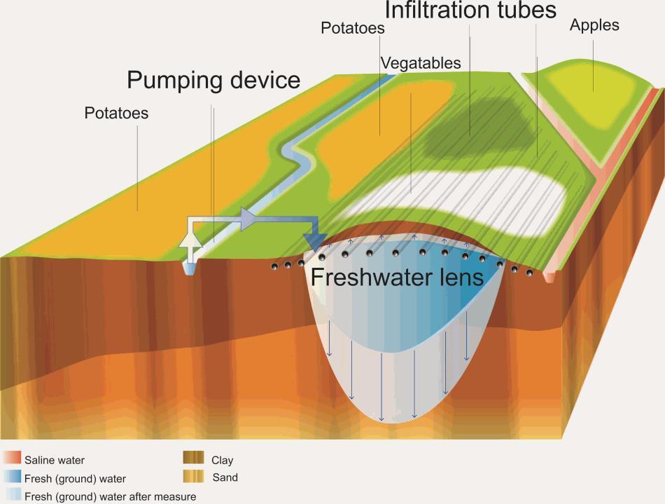
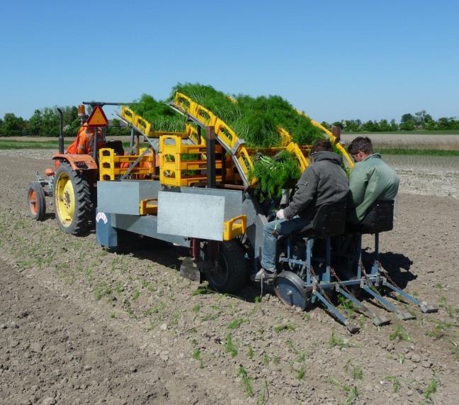
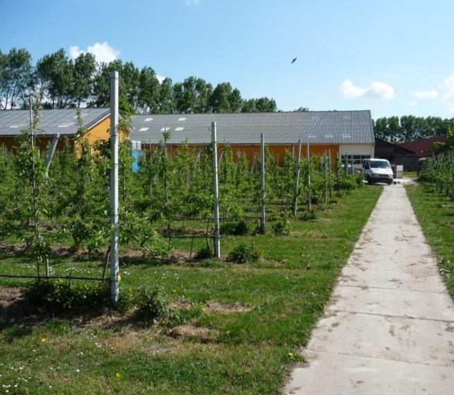
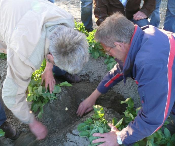
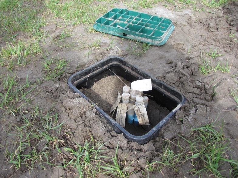
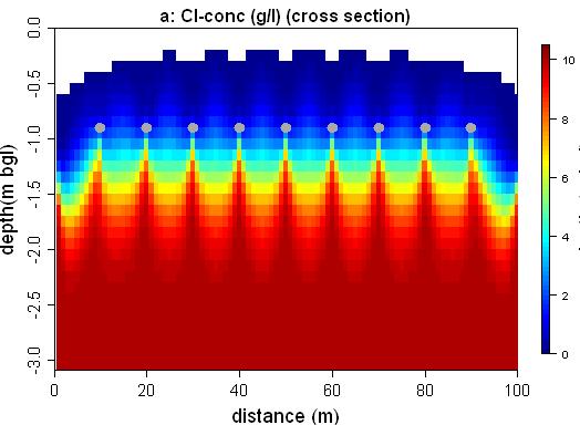
22 EXAMPLE 2: CASE ON A LOCAL 3D MODEL salty water fresh water Schouwen-Duiveland Local model: 3D, MOCDENS3D salt-fresh 5*5m2 cells m N low ditch high m SFWMD De Louw et al., Hydrol. Earth Syst. Sci. Discuss., 8, , shallow fresh water lens


23 COMPARISON MONITORING DATA WITH MODEL RESULTS a) Airborne EM 5*5m SFWMD
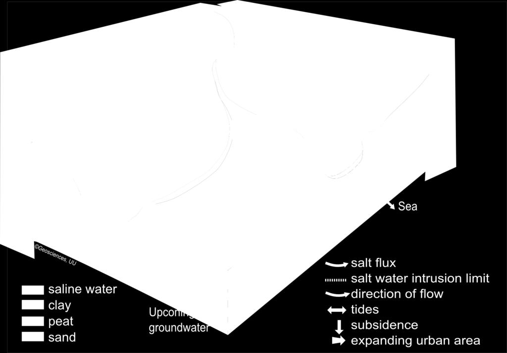
24 MODELLlNG CL-CONC. WITH DIFFERENT CC SCENARIOS W Present W SFWMD W W sea level rise green is too salty to grow fresh crops
25 MODELLlNG CL-CONC. WITH DIFFERENT CC SCENARIOS W Present W SFWMD W W sea level rise green is too salty to grow fresh crops
26 MODELLlNG CL-CONC. WITH DIFFERENT CC SCENARIOS W Present W SFWMD W W sea level rise green is too salty to grow fresh crops

27 MODELLlNG CL-CONC. WITH DIFFERENT CC SCENARIOS W Present W SFWMD W W sea level rise green is too salty to grow fresh crops
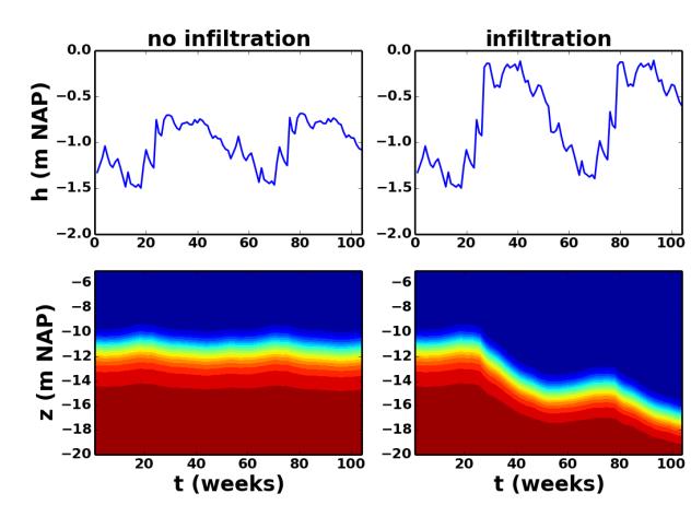
28 CREEKRIDGE INFILTRATION SYSTEM: AQUIFER STORAGE SYSTEM Modelling result Monitoring result

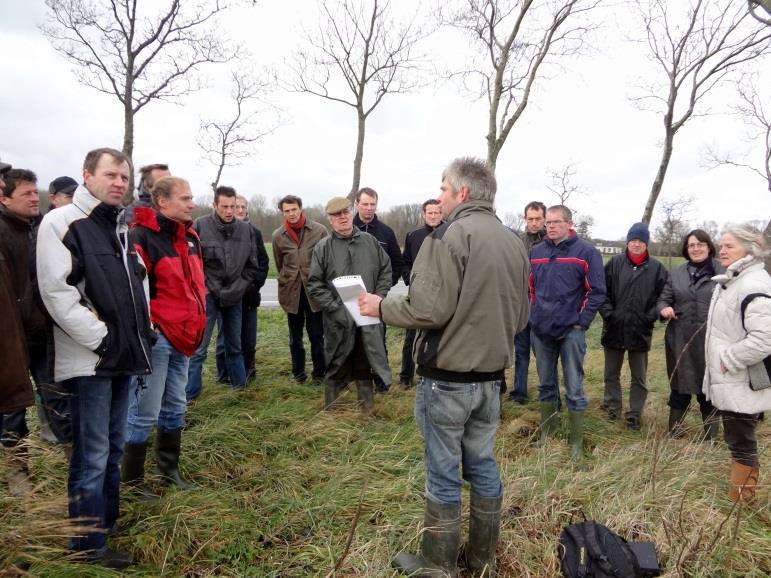
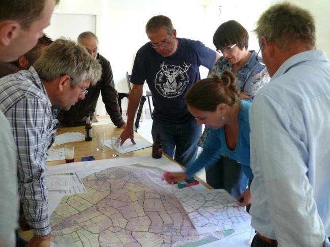
29 STAKEHOLDER PARTICIPATION AND KNOWLEDGE TRANSFER apple trees people knowledge fennel potatoes

30 EXAMPLE 3: UPCONING OF BRACKISH-SALINE GROUNDWATER Stuyfzand, 1993? SFWMD

31 SALTWATER INTRUSION IN THE DUTCH COASTAL ZONE sea dunes polder fingering upconing wells upconing polder salt inclusion
32 SALTWATER Saltwater intrusion INTRUSION in IN the THE Dutch DUTCH coastal COASTAL zone ZONE


")

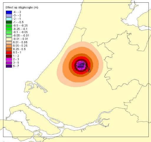
33 EXAMPLE 4 3D FRESH-SALT MODEL PROVINCE ZUID-HOLLAND Land subsidence Sea level rise Change in recharge Top layer Enschede/Kedichem Tegelen/Belfelt Top layer Enschede/Kedichem Tegelen/Belfelt Maassluis Kallo Maassluis aquifer difference in head (m) Hydrogeologic base Hydrogeologic base SFWMD


34 MODELSTUDY ZUID-HOLLAND 100km * 92.5km * 300m depth ~4 million active cells Land subsidence Sea level rise Change in natural groundwater recharge Present recharge scenarios GW recharge mm/day e.g. KNMI 06 W Summer: -38% Winter:+28% Land subsidenc SFWMD
35 ZONE OF INFLUENCE OF SEA LEVEL RISE backwater effect surface water

36 ZONE OF INFLUENCE OF SEA LEVEL RISE backwater effect surface water
37 Change in freshwater head [m] ZONE OF INFLUENCE OF SEA LEVEL RISE Case 1 with subsoil parameters Seepage mm/day Seepage [m/day] kd = 5000 m2/day c = 5000 day l = 5000 m D (x) x/ l 0 e Dq(x) D (x) / c l= sqrt(kdc) Length [m] Length [m]
38 Change in freshwate head [m] Seepage mm/day Kwel [m/dag] ZONE OF INFLUENCE OF SEA LEVEL RISE: Case 2 with subsoil parameters GOOD PERMEABLE AQUITARD kd = 5000 m2/dag c1 = 5000 dag c2 = 50 dag Length [m] Lengte [m]


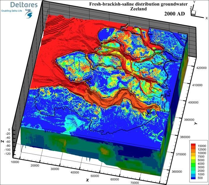
39 EXAMPLE 5 SALINISATION AND FRESHENING UNDER GLOBAL STRESSES Regional model SFWMD Source: NHI 250*250m 2 Source: model Zeeland 100*100m 2
40 EXAMPLE 6 Thé Dutch Integrated Modelling Example The Netherlands Hydrological Instrument
 = main goal of NHI Sea level rise and precipitation pattern Land subsidence Adaptive and mitigative strategies Changing water")
41 THE NETHERLANDS HYDROLOGICAL INSTRUMENT Main goals for water management of our national government: To protect The Netherlands from flooding To make Fresh Water Supply Climate Change Proof They needed a model that can assess the effects of: Droughts (water demands) = main goal of NHI Sea level rise and precipitation pattern Land subsidence Adaptive and mitigative strategies Changing water management (lake saline again, lake higher water level) Coming years: nutrient emissions and pesticide leaching, etc. So we made NHI! First model dates from 2006.

42 THE NETHERLANDS HYDROLOGICAL INSTRUMENT Dx=250m 1200 columns 1300 rows 7 layers ~2.5M stresses

43 COMPONENTS water balance of sub-catchments and main surface waters salt in surface water system fluxes and heads in unsaturated and saturated groundwater salt concentration in saturated groundwater and salt flux to surface water.


44 COMPONENTS Domain Computation Unit Unit size Surface Water Node-node 1-25km Time step 1-10day Surface Water Line 0.5km 1day Surface Water Polygon 5km2 10day Soil Vegetation Atmosphere Grid cell 250m 1day Scale of process Purpose Present name Nationwid e Optimization of water distribution DM Nationwid e Flow and Transport LSM Subcatchm Distribution to users of ent groundwater & surface water Mozart Plot, Transfer of Water in root zone, soil colomn water deficit Groundwater Grid cell 250m 1day Regional Flow and Transport MetaSWAP MODFLOW- SEAWAT DEM 0.5m x 0.5m ~16,000 boreholes 18% surface water De Lange et al., An operational, multi-scale, multi-model system for consensus-based, integrated water management and policy analysis: The Netherlands Hydrological Instrument. Environmental Modelling & Software 59,
: SEAWAT, MOCDENS3D MT3D, imod, link NHI,")
45 NUMERICAL MODELLING OF SALT WATER INTRUSION Characteristics: variable-density groundwater fresh, brackish and saline 3D, non-steady coupled solute transport heat transport Assess combined effects: past land subsidence polders sea level rise changing recharge pattern land subsidence changing extraction rates adaption measures Software (MODFLOW family): SEAWAT, MOCDENS3D MT3D, imod, link NHI, etc SFWMD


46 3D REGIONAL COASTAL GROUNDWATER MODEL STUDIES Netherlands, Zeeland Singapore Modelling: variable-density groundwater flow, coupled solute transport Nile Delta, Egypt Simulating effects of: autonomous processes (change extraction rates) sea level rise, changing recharge pattern land subsidence Quantifying: hydraulic head saline seepage / infiltration fresh groundwater resources

47 NUMERICAL MODELLING FRESH-SALT GROUNDWATER IN NL SFWMD modelling without salt is wrong
48 TWO APPROACHES OF MODELLING DELTAIC AREAS 2D Conceptual modelling Improves conceptual understanding of the groundwater system Scientific papers 3D Variable-density groundwater flow modelling Often actual situation in the field Real problems under pressure Focus on case studies with impact analysis
49 QUESTIONS TO BE ANSWERED Where are the present fresh-saline interfaces? How will these interfaces evolve in the following decades? What is the effect of the extractions in the vertical distribution of the salinity? Guiding the positioning of monitoring and data collection Guiding the positioning of (new) extraction wells
50 WHY A 3D VARIABLE-DENSITY GROUNDWATER MODEL To better understand and visualize the groundwater dynamics and relevant salinity processes: lateral surface salt water intrusion lateral salt groundwater intrusion vertical up-coning under extractions and low-lying areas infiltration of salt water due to inundations caused by storm surges. To provide Bangladeshi water managers and universities with an instrument for their mandates on secure water supply, now and in the future To assess the impact of global and climate change (including the effect of sea level rise) To give future local models correct boundary conditions


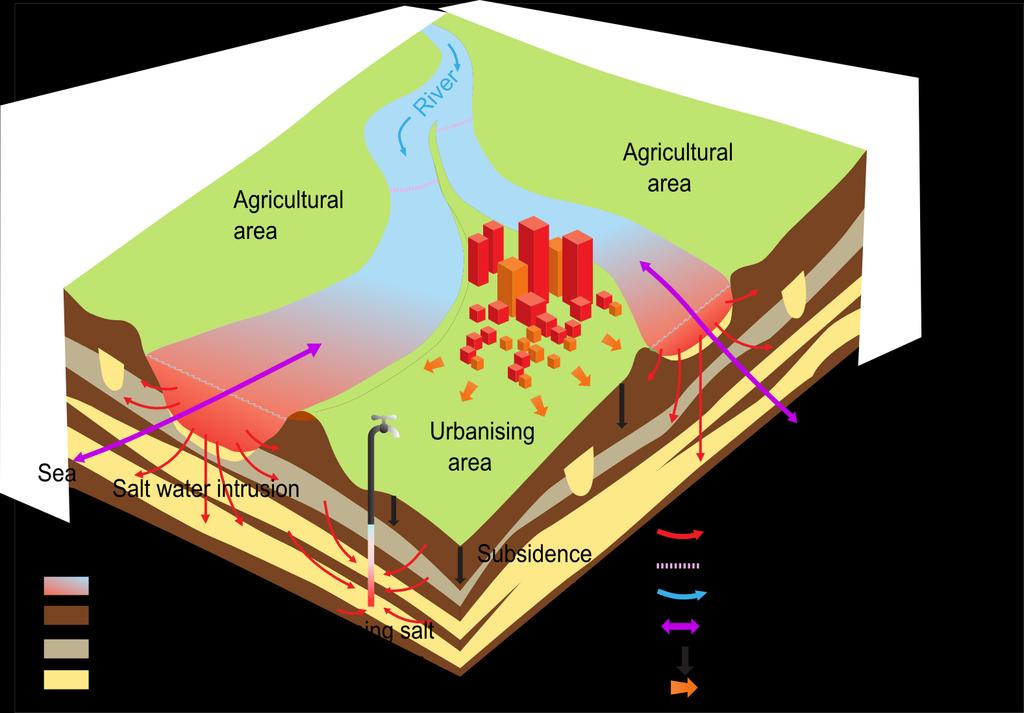
51 Salinisation processes at local scale SALINIZATION PROCESSES Salt water intrusion surface water (and groundwater) Salt water intrusion groundwater Shallow freshwater lenses and saline seepage Upconing low-lying area Upconing under groundwater extraction Shallow vertical salt water intrusion after flooding event (storm surge)


 Extended")
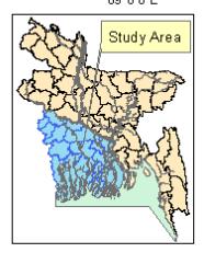
52 COMPUTER CODE 3D numerical variable-density groundwater flow and coupled salt transport model of the central coastal zone of Bangladesh Built in SEAWAT (= MODFLOW-MT3DMS-density ) Extended with imod functionality

53 Bangladesh
54 SALINIZATION PROCESSES IN THE COASTAL ZONE


55 MODEL GEOMETRY: MODEL EXTENT Bottom boundary: Boka Bil formation hydrological base (no flow) Input from Holly Michael & Cliff Voss 274 Km focus on top 500m 317 Km m
56 THE MODFLOW GRID
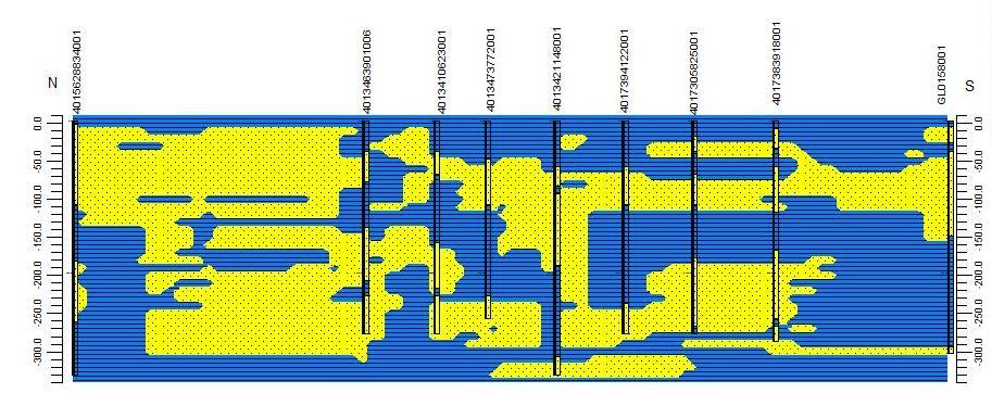
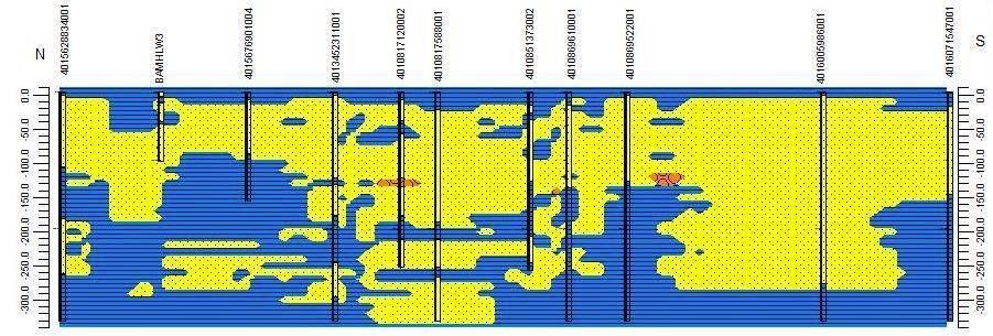
57 N-S CROSS-SECTIONS OF BAGERHAT, IT IS A PATHY COMPLEX GEOLOGIC SYSTEM


58 GEOLOGY K h =hor. cond. [m/d] Source: Dr. Bashar K v =vert. cond. [m/d]

59 SURFACE LEVEL (DEM) SUBSURFACE MODEL Geological data from Holly Michael & Cliff Voss Sources: CEGIS, BGS, DPHE, D data as input, e.g. boreholes to build up the subsurface: aquifers and aquitards
60 MODELLING RECHARGE Recharge: the RCH package Q RCH Q RCH = Q i,j,k gridcell i,j,k So 1 map needed: Map of recharge rates


61 NET GROUNDWATER RECHARGE Interpolation measured data (source CEGIS): 4 monitoring stations for evapotranspiration 96 monitoring stations for precipitation ± Data averaged per stress period: 1. Cold and dry Nov - Feb 2. Hot and humid Mar - May 3. Monsoon season June - October
62 MODELLING SURFACE WATER: RIVER PACKAGE river loses water river gains water riv riv i,j,k river bottom RBOT gridcell i,j,k gridcell i,j,k Q riv = C riv ( riv i,j,k ) Special case: if i,j,k < RBOT, then Q riv = C riv ( riv RBOT) So 3 maps needed: 1. Map of river stages 2. Map of river conductances 3. Map of river bottoms
 CEGIS,")
63 SURFACE WATER: SALINITY LEVELS IN RIVER PACKAGE 1. Cold and dry Nov - Feb 2. Hot and humid Mar - May 3. Monsoon season Jun - Oct Main waterways shown here, smaller waterways via diffuse approach Source: Daily water level data from BWBD (126 locations on river levels) CEGIS, completed by data from DIVA-GIS (84 monitoring stations on salinity values)
 demand 50 L/day per capita (WARPO, 2000) assumed constant throughout the year Q well (m 3 /(day*km 2 ) Irrigation")

64 GROUNDWATER EXTRACTIONS Q well Domestic&Industrial based on population size (cf Michael and Voss, 2009) total (domestic + industrial) demand 50 L/day per capita (WARPO, 2000) assumed constant throughout the year Q well (m 3 /(day*km 2 ) Irrigation for agricultural purposes known is area per irrigation type, on district level distinction between wet season and dry season irrigation Shallow Tube Well : 10-60m depth irrigation Deep Tube Well: m depth Source: depth based on the well data of DPHE shallow, dry
65 MODELLING RECHARGE Q well Extractions: the Well package Q wel = Q i,j,k gridcell i,j,k So one map needed: Map of well locations with extraction rates Domestic and Industrial Q well (m 3 /(day*km 2 ) = Population size * growth rate* Water demand Upazila surface area Agricultural Q well (m 3 /(day*km 2 ) = Irrigated area * withdrawal rate district surface area


66 imod-seawat TO BUILD A 3D VARIABLE-DENSITY GRW. MODEL ASCII S as input E.g. surface elevation Analysis of the output as ASCIIS and 3D figures and data sets 3D data as input, e.g. boreholes to build up the subsurface: aquifers and aquitards SFWMD

67 MASS BALANS GROUNDWATER IN DRY SEASON WET SEASON via boundaries 2% 0% via wells 0% 0% via river 98% 0% via recharge 0% 100% OUT via boundaries 0% 1% via wells 54% 4% via river 0% 95% via evapotranspiration 46% 0%

68 MODEL RESULTS: HEADS
69 MODEL RESULTS: HEADS

70 MODEL RESULTS: HEADS
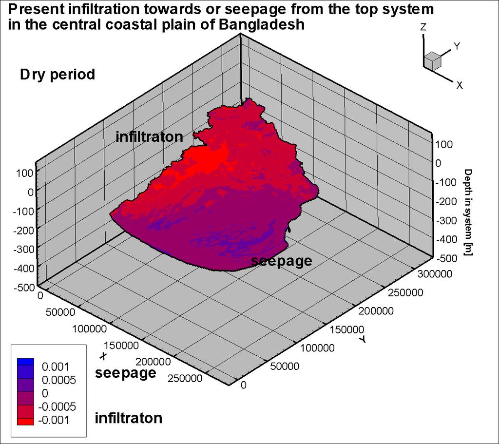
71 MODEL RESULTS: SEEPAGE/INFILTRATION
72 MODEL RESULTS: 3D-SALINITY
73 MODEL RESULTS: 3D-SALINITY

74 MODEL RESULTS: 3D-SALINITY

75 CONCLUDING REMARKS 1. The 3D model of variable-density groundwater flow and coupled salt transport model is operational in its present base form 2. The used imod-seawat modelling tool is OPEN SOURCE 3. The initial fresh-brackish-salt distribution has been improved by the additional data 4. The complex hetereogeneous system can be modelled with the code without numerical problem 5. Different concepts have been tested Recommendations for improvements: Calibration on heads and salinity distribution Simulation of non-steady state seasonal groundwater flow After implementation of these suggestions, the model is suitable to simulate global change scenarios on extraction rates, land subsidence and climate change (sea level rise).
76 Thank you for your attention!
SWIBANGLA. Managing Salt Water Impacts in Bangladesh. Marta Faneca Sanchez Gualbert Oude Essink Gijs Janssen Roelof Stuurman Yangxiao Zhou, UNESCO-IHE
 SWIBANGLA Managing Salt Water Impacts in Bangladesh Marta Faneca Sanchez Gualbert Oude Essink Gijs Janssen Roelof Stuurman Yangxiao Zhou, UNESCO-IHE Project duration spring 2013 to winter 2014 http://flood.firetree.net
SALINISATION OF THE NORTHERN COASTEL AREA OF THE NETHERLANDS DUE TO LAND SUBSIDENCE AND SEA LEVEL RISE
 SALINISATION OF THE NORTHERN COASTEL AREA OF THE NETHERLANDS DUE TO LAND SUBSIDENCE AND SEA LEVEL RISE PERRY DE LOUW AND GUALBERT OUDE ESSINK TNO Geological Survey of the Netherlands P.O. Box 815, 358TA
On fresh-saline groundwater in coastal zones
 On fresh-saline groundwater in coastal zones The salinisation of fresh groundwater resources leads to serious problems for farmers, (drinking) water companies, industry and water managers in deltas and
Hydrogeology of the Merti Aquifer. Impact of abstractions on drawdown of water level and salinity. Arjen Oord Jan de Leeuw (presenter)
") Hydrogeology of the Merti Aquifer Impact of abstractions on drawdown of water level and salinity Arjen Oord Jan de Leeuw (presenter) Impacts of abstractions? Abstractions have two major geo-hydrological
Hydrogeology of the Merti Aquifer Impact of abstractions on drawdown of water level and salinity Arjen Oord Jan de Leeuw (presenter) Impacts of abstractions? Abstractions have two major geo-hydrological
1 juli Basic stuff. Just impressions! Introduction Basic stuff Stuff I like AEM. Manual: I know nothing (Fawlty Towers)
") Manual: I know nothing (Fawlty Towers) Geophysics Applied to Coastal Aquifer Studies Gualbert Oude Essink Outline Need more information?: Helga Wiederhold Yossi Yechieli Vincent Post Luc Lebbe/Alexander
Manual: I know nothing (Fawlty Towers) Geophysics Applied to Coastal Aquifer Studies Gualbert Oude Essink Outline Need more information?: Helga Wiederhold Yossi Yechieli Vincent Post Luc Lebbe/Alexander
Improvement of the national water balance feasibility of water balances per river basin
 Improvement of the national water balance feasibility of water balances per river basin Report on Grant agreement No 50303.2010.001-2010.564 Cor Graveland & Kees Baas By: Water Accounts / Water Statistics
An Introduction into Applied Soil Hydrology
 Klaus Bohne An Introduction into Applied Soil Hydrology Preface Contents 1 Introduction: The soil as a reactor between the earth's atmosphere and the subsurface 1 2 Mechanical composition of mineral soils
Identifying suitable measures to enlarge fresh groundwater reserves on a regional scale A feasibility study in Walcheren, the Netherlands
 Identifying suitable measures to enlarge fresh groundwater reserves on a regional scale A feasibility study in Walcheren, the Netherlands MSc internship report Hydrology and Quantitative Water Management
Climate change Adriatic coast Emilia- Romagna (Italy): wet and dry seasons more distinct.
: wet and dry seasons more distinct.") DISCONTINUOUS RECHARGE OF FRESH WATER LENSES ALONG THE ADRIATIC COAST, ITALY Pauline Mollema and Marco Antonellini, University of Bologna (Italy) Gualbert Oude Essink, Deltares (Netherlands) Climate change
DISCONTINUOUS RECHARGE OF FRESH WATER LENSES ALONG THE ADRIATIC COAST, ITALY Pauline Mollema and Marco Antonellini, University of Bologna (Italy) Gualbert Oude Essink, Deltares (Netherlands) Climate change
D.G.S.W. Pitakumbura Manager (Groundwater Studies) Groundwater Section NWS&DB. Groundwater recharge or deep drainage or
 Groundwater Section NWS&DB. Groundwater recharge or deep drainage or") Groundwater Recharge and Extraction Techniques D.G.S.W. Pitakumbura Manager (Groundwater Studies) Groundwater Section NWS&DB What is Groundwater Recharge Groundwater recharge or deep drainage or deep percolation
Groundwater Recharge and Extraction Techniques D.G.S.W. Pitakumbura Manager (Groundwater Studies) Groundwater Section NWS&DB What is Groundwater Recharge Groundwater recharge or deep drainage or deep percolation
CHAPTER 7 GROUNDWATER FLOW MODELING
 148 CHAPTER 7 GROUNDWATER FLOW MODELING 7.1 GENERAL In reality, it is not possible to see into the sub-surface and observe the geological structure and the groundwater flow processes. It is for this reason
Genetic Algorithm based Simulation Optimization Approach to Seawater Intrusion
 International Symposium on Genetic Algorithm based Simulation Optimization Approach to Seawater Intrusion 1313 Integrated Water Resources Management (IWRM 2014) February 19 21, 2014, CWRDM, Kozhikode,
Seawater intrusion into coastal aquifers a case study
 The Sustainable City V 213 Seawater intrusion into coastal aquifers a case study J. Letha & D. B. Krishnan Civil Engineering Department, College of Engineering, Trivandrum, India Abstract Seawater intrusion
Water Resources on PEI: an overview and brief discussion of challenges
 Water Resources on PEI: an overview and brief discussion of challenges Components: Components and links Atmospheric water Surface water (including glacial water) Groundwater Links: Precipitation (atm(
Numerical Groundwater Model for the Kaweah Delta Water Conservation District
 Numerical Groundwater Model for the Kaweah Delta Water Conservation District Nels Ruud and Peter Leffler Fugro West, Inc. Larry Dotson Kaweah Delta Water Conservation District Presentation Outline Background
Octa Journal of Environmental Research
 Octa Journal of Environmental Research Oct Dec., 2015 International Peer-Reviewed Journal ISSN 2321 3655 Oct. Jour. Env. Res. Vol. 3(4): 264-271 Available online http://www.sciencebeingjournal.com Review
Linking Soil Water and Groundwater Models to Investigate Salinity Management Options
 Linking Soil Water and Groundwater s to Investigate Salinity Management Options Carl C. Daamen a and Greg P. Hoxley a a Sinclair Kight Merz, P.O.Box 25, Malvern, VIC 3162, Australia. Abstract: Salinisation
Effect of Groundwater Pumping on Seawater Intrusion in Coastal Aquifers
 Agricultural Sciences, 7(2):61-67 (2002) 2002 Sultan Qaboos University Effect of Groundwater Pumping on Seawater Intrusion in Coastal Aquifers M.M. Sherif 1 * and V.P. Singh 2 1 Civil Engineering Department,
Water Resources Management: Vulnerability of Coastal Aquifers to Climate Change & Human Effects.
 Water Resources Management: Vulnerability of Coastal Aquifers to Climate Change & Human Effects. Water Resources of The Bahamas College of the Bahamas Lecture (Oct-2011) John A. Bowleg Engineer / Hydrologist
Dutch research on drought in relation to European drought policy
 Dutch research on drought in relation to European drought policy Remco van Ek remco.vanek@deltares.nl Drought and low flows, including groundwater NHV international conference, Maastricht October 24 th
Self-supporting freshwater availability along the coastal zones in the Netherlands Spaarwater
 Self-supporting freshwater availability along the coastal zones in the Netherlands Spaarwater Implementing climate resilient water management projects to increase adaptive capacities, food security & avoid
Irrigation modeling in Prairie Ronde Township, Kalamazoo County. SW Michigan Water Resources Council meeting May 15, 2012
 Irrigation modeling in Prairie Ronde Township, Kalamazoo County SW Michigan Water Resources Council meeting May 15, 2012 Development of a Groundwater Flow Model INFLOWS Areal recharge from precipitation
Managed Aquifer Recharge (MAR) Practical Techniques for the Caribbean
 Practical Techniques for the Caribbean") Managed Aquifer Recharge (MAR) Practical Techniques for the Caribbean Scope of Presentation What is MAR? Antigua and Barbuda water resources issues Why promote MAR? MAR: Techniques MAR: Design criteria
Managed Aquifer Recharge (MAR) Practical Techniques for the Caribbean Scope of Presentation What is MAR? Antigua and Barbuda water resources issues Why promote MAR? MAR: Techniques MAR: Design criteria
Journal of American Science 2014;10(9)
") Adaptation to the Impact of Sea Level Rise in the Nile Delta Coastal zone, Egypt Eman R. Nofal 1, Akram M. Fekry 2 And Sherif M. El-Didy 3 1 Research Institute for Groundwater, National Water Research
Adaptation to the Impact of Sea Level Rise in the Nile Delta Coastal zone, Egypt Eman R. Nofal 1, Akram M. Fekry 2 And Sherif M. El-Didy 3 1 Research Institute for Groundwater, National Water Research
TSUNAMI DISASTER AND GROUNDWATER RESOURCES: THE SOUTHEASTERN COAST OF INDIA. Bhanu Neupane Regional Hydrologist, UNESCO
 TSUNAMI DISASTER AND GROUNDWATER RESOURCES: THE SOUTHEASTERN COAST OF INDIA Bhanu Neupane Regional Hydrologist, UNESCO Background On December 26, 2004, Tsunami waves struck the coast of the Indian subcontinent
GSP Coordinating Committee
 GSP Coordinating Committee Coordinating Committee Meeting August 27, 2018 Merced Irrigation-Urban GSA Merced Subbasin GSA Turner Island Water District GSA-1 Agenda 1. Call to Order 2. Approval of Minutes
K.Fujinawa 1 ABSTRACT
 The Second International Conference on Saltwater Intrusion and Coastal Aquifers Monitoring, Modeling and Management. Merida, Yucatan, Mexico, March 30-April 2, 2003 The Impact of Future Possible Sea Level
WASA Quiz Review. Chapter 2
 WASA Quiz Review Chapter 2 Question#1 What is surface runoff? part of the water cycle that flows over land as surface water instead of being absorbed into groundwater or evaporating Question #2 What are
organized by INDUCED RIVERBANK FILTRATION FOR MANAGED ARTIFICIAL GROUNDWATER RECHARGE AT APAČE FIELD Matevž Vremec, Irena Kopač
 organized by INDUCED RIVERBANK FILTRATION FOR MANAGED ARTIFICIAL GROUNDWATER RECHARGE AT APAČE FIELD Matevž Vremec, Irena Kopač Objectives Shallow aquifer of Apače field Efficiency analysis of a MAR system
4.4 MODEL CODE DESCRIPTION 4.5 WATER SOURCES AND SINKS 4.6 MODEL DOMAIN AND BOUNDARIES. SLR South Africa
 Page 4-18 The developed model should therefore be seen as an initial site model which should be refined and recalibrated once more groundwater monitoring and other data become available. 4.4 MODEL CODE
Climate Change: Implications for Groundwater Recharge and Saltwater Intrusion on the Gulf Islands
 Climate Change: Implications for Groundwater Recharge and Saltwater Intrusion on the Gulf Islands Diana M. Allen Department of Earth Sciences Groundwater Resources Research Group Simon Fraser University
Measuring & modelling soil water balance and nitrate leaching of perennial crops in New Zealand
 Measuring & modelling soil water balance and nitrate leaching of perennial crops in New Zealand Steve Green, Brent Clothier, Karin Müller Key facts: Water allocation in New Zealand Abundant freshwater
Implications of Climate Change on Water Management in Bangladesh
 Implications of Climate Change on Water Management in Bangladesh February 6, 28 Jahir Uddin Chowdhury Professor Institute of Water and Flood Management BUET, Dhaka-1, Bangladesh 1. Introduction Bangladesh
Predicting seasonal variation and mounding of groundwater in shallow groundwater systems
 Predicting seasonal variation and mounding of groundwater in shallow groundwater systems Mr Kelly Norris Senior Engineer, Essential Environmental, Perth, Australia E-mail: kelly@essentialenvironmental.com.au
Synopsis. Geoffrey R. Tick Dorina Murgulet Hydrogeology Group The University of Alabama UA Project Number Grant # 09-EI UAT-2
 Assessment of Groundwater Flow Paths and Discharge to the Coastal Region of Baldwin County, Alabama to Understand Contaminant Transport using a Cross- Sectional Groundwater Flow and Transport Synopsis
Associate Groundwater Resources Engineer Principal Hydrogeologist
 Project No.: 140369 March 2, 2016 Revised March 25, 2016 To: Cami Apfelbeck From: Peter Bannister, PE Timothy Flynn, LHG, CGWP Associate Groundwater Resources Engineer Principal Hydrogeologist pbannister@aspectconsulting.com
Response to Reviewers #2 Comments (Major review): Manuscript NHESS
: Manuscript NHESS") Response to Reviewers #2 Comments (Major review): Manuscript NHESS-2013-167 The authors thank the reviewer for their helpful comments and suggestions. In the document below we have listed the reviewer
Response to Reviewers #2 Comments (Major review): Manuscript NHESS-2013-167 The authors thank the reviewer for their helpful comments and suggestions. In the document below we have listed the reviewer
Introduction to Groundwater Science
 Introduction to Groundwater Science Laila Kasuri LUMS - WIT Overview Groundwater Hydrology and Basic Terms Groundwater Movement and Flow Groundwater Challenges Groundwater Management What is Groundwater
Ingress of salinity in coastal area
 Ingress of salinity in coastal area P re p a re d B y : - Patel Hardik P. Patel Dax S. Patel Sapana S. Patel Hiral J. (En No.110780106034) (En No.110780106026) (EnNo.110780106011) (En No.110780106023)
Climate Change and Sea Level Rise
 Potential Effects of Sea-Level Rise on the Hydrologic System of Cape Cod, Massachusetts 3 rd Cape Coastal Conference, December 7, 2016 Continued release of anthropogenic greenhouse gases is resulting in
Potential effects evaluation of dewatering an underground mine on surface water and groundwater located in a rural area
 Potential effects evaluation of dewatering an underground mine on surface water and groundwater located in a rural area ITRODUCTIO Michel Mailloux* Eng. M.Sc, Vincent Boisvert, M.Sc, Denis Millette, Eng.,
Integrated surface water and groundwater modelling to support the Murray Drainage and Water Management Plan, south-west Western Australia
 19th International Congress on Modelling and Simulation, Perth, Australia, 12 16 December 2011 http://mssanz.org.au/modsim2011 Integrated surface water and groundwater modelling to support the Murray Drainage
Surface Water and Seawater Interactions in the Coastal Environment of Biscayne Bay, Southeast Florida
 Surface Water and Seawater Interactions in the Coastal Environment of Biscayne Bay, Southeast Florida William C. Hutchings, MS, PG Nicholas Albergo, PE, DEE Paper No. 191-8 2005 Salt Lake City Annual Meeting
Afternoon Lecture Outline. Northern Prairie Hydrology
 Afternoon Lecture Outline 1. Northern Prairies watershed hydrology 2. Solute mass balance in lakes and ponds 3. Simple mass balance simulation using MS Excel 4. Effects of sediment-water exchange on lake
MODELLING THE GROUNDWATER FLOW FOR ESTIMATING THE PUMPING COST OF IRRIGATION IN THE AQUIFER OF N. MOUDANIA, GREECE
 Proceedings of the 13 th International Conference on Environmental Science and Technology Athens, Greece, 5-7 September 2013 MODELLING THE GROUNDWATER FLOW FOR ESTIMATING THE PUMPING COST OF IRRIGATION
Afternoon Lecture Outline. Northern Prairie Hydrology
 Afternoon Lecture Outline 1. Northern Prairies watershed hydrology 2. Solute mass balance in lakes and ponds 3. Simple mass balance simulation using MS Excel 4. Effects of sediment-water exchange on lake
Feasibility Study of Artificial Aquifer Recharge in the Walla Walla Basin. Presenter: Arístides Petrides
 Feasibility Study of Artificial Aquifer Recharge in the Walla Walla Basin Presenter: Arístides Petrides Overview of Presentation Background Walla Walla River Basin Previous Modeling Effort with IWFM New
Groundwater Balance Study in the High Barind, Bangladesh. A.H.M.Selim Reza 1, Quamrul Hasan Mazumder 1 and Mushfique Ahmed 1
 Rajshahi University J. of Sci. 39, 11-26 (2011) ISSN 1681-0708 Groundwater Balance Study in the High Barind, Bangladesh A.H.M.Selim Reza 1, Quamrul Hasan Mazumder 1 and Mushfique Ahmed 1 1 Department of
A MODEL OF SEAWATER INTRUSION IN SURFICIAL AND CONFINED AQUIFERS OF NORTHEAST FLORIDA
 The Second International Conference on Saltwater Intrusion and Coastal Aquifers - Monitoring, Modeling, and Management. Mérida, Yucatán, México, March 30 - April 2, 2003 A MODEL OF SEAWATER INTRUSION IN
DYNFLOW accepts various types of boundary conditions on the groundwater flow system including:
 Section 6 Groundwater Flow Model A groundwater flow model was developed to evaluate groundwater flow patterns in the site area and to provide a basis for contaminant transport modeling. 6.1 Model Code
BAEN 673 / February 18, 2016 Hydrologic Processes
 BAEN 673 / February 18, 2016 Hydrologic Processes Assignment: HW#7 Next class lecture in AEPM 104 Today s topics SWAT exercise #2 The SWAT model review paper Hydrologic processes The Hydrologic Processes
Modeling the Contamination of an Aquifer from a Highway Salt Storage Facility
 First International Conference on Saltwater Intrusion and Coastal Aquifers Monitoring, Modeling, and Management. Essaouira, Morocco, April 23 25, 01 Modeling the Contamination of an Aquifer from a Highway
NUMERICAL MODELLING OF SALTWATER PLUME MOVEMENT IN A FRACTURED AQUIFER ON SUB-REGIONAL SCALE
 NUMERICAL MODELLING OF SALTWATER PLUME MOVEMENT IN A FRACTURED AQUIFER ON SUB-REGIONAL SCALE Sascha E. Oswald (Groundwater Protection and Restoration Group, University of Sheffield, United Kingdom) INTRODUCTION
Sensitivity to Sea Level Rise (NRCan, 2009) :
 :") Climate change and potential impact on Coastal aquifers in ATLANTIC CANADA: Initial Findings Brian Hansen 1, Calvin Beebe 1, Grant Ferguson 1, Nathan Green 2, Kerry MacQuarrie 2, Eric Mott 2, Karl Butler
Climate change and potential impact on Coastal aquifers in ATLANTIC CANADA: Initial Findings Brian Hansen 1, Calvin Beebe 1, Grant Ferguson 1, Nathan Green 2, Kerry MacQuarrie 2, Eric Mott 2, Karl Butler
Long-term water level changes in closed-basin lakes of the Canadian prairies and the role of groundwater
 Long-term water level changes in closed-basin lakes of the Canadian prairies and the role of groundwater Garth van der Kamp, Environment Canada, Saskatoon Masaki Hayashi, Dwayne Keir, Alan Barr, Little
General Groundwater Concepts
 General Groundwater Concepts Hydrologic Cycle All water on the surface of the earth and underground are part of the hydrologic cycle (Figure 1), driven by natural processes that constantly transform water
Groundwater Recharge from Agricultural Areas in the Flatwoods Region of South Florida 1
 ABE 370 Groundwater Recharge from Agricultural Areas in the Flatwoods Region of South Florida 1 Sanjay Shukla and Fouad H. Jaber 2 Introduction Groundwater provides freshwater for drinking, agricultural
Assessment of the Groundwater Quantity Resulting from Artificial Recharge by Ponds at Ban Nong Na, Phitsanulok Province, Thailand
 Research article erd Assessment of the Groundwater Quantity Resulting from Artificial Recharge by Ponds at Ban Nong Na, Phitsanulok Province, Thailand SIRIRAT UPPASIT* Faculty of Technology, Khon Kaen
Agronomy 406 World Climates
 Agronomy 406 World Climates February 13, 2018 Hydrologic cycle. Team 4 Climate News presentation this Thursday. Review: METED module, Understanding the Hydrologic Cycle Active review session for the midterm
4. Groundwater Resources
 4. Groundwater Resources 4-1 Majority (97 %) of unfrozen fresh water on earth exists as groundwater. In comparison to surface water, - groundwater is available all year around - groundwater is mostly invisible
Groundwater 3/16/2010. GG22A: GEOSPHERE & HYDROSPHERE Hydrology
 GG22A: GEOSPHERE & HYDROSPHERE Hydrology Definitions Groundwater Subsurface water in soil or rock that is fully saturated. Aquifer Contains enough saturated material to yield significant quantities of
The Impact of Climate Change on Surface and Groundwater Resources and their Management. I Concepts, Observations, Modeling.
 The Impact of Climate Change on Surface and Groundwater Resources and their Management I Concepts, Observations, Modeling Manfred Koch Department of Geohydraulics and Engineering Hydrology, University
Quantifying Effects of Humans and Climate on Groundwater Resources Through Modeling of Volcanic-Rock Aquifers of Hawaii
 Quantifying Effects of Humans and Climate on Groundwater Resources Through Modeling of Volcanic-Rock Aquifers of Hawaii University of Hawaii Volcanic rock Freshwater Saltwater Kolja Rotzoll, Scot K. Izuka,
Manifesto from the Workshop Climate Change Impacts on Groundwater
 Manifesto from the Workshop Climate Change Impacts on Groundwater EU Working Group C workshop October 12th, Warsaw A workshop on Climate Change Impacts on Groundwater was held in Warsaw under the umbrella
Groundwater in the Santa Rosa Plain
 . Groundwater in the Santa Rosa Plain Marcus Trotta, PG, CHg Principal Hydrogeologist Sonoma County Water Agency Santa Rosa Plain Groundwater Sustainability Agency October 12, 2017 www.sonomacountywater.org
Groundwater. Groundwater Movement. Groundwater Movement Recharge: the infiltration of water into any subsurface formation.
 On March 22, 2014, a major landslide occurred near Oso, Washington. Death toll currently at 30, with 15 still missing. Groundwater Before and After Swipe http://bit.ly/pen1jt N. Fork Stillaguamish River
SIMULATION OF FRESHWATER-SEAWATER INTERFACE BY EMPLOYING CARTESIAN MESH ON THE FEM MODEL (Case Study : Semarang Aquifer INDONESIA)
") Proceedings of the 7 th International Conference on Asian and Pacific Coasts (APAC 2013) Bali, Indonesia, September 24-26, 2013 SIMULATION OF FRESHWATER-SEAWATER INTERFACE BY EMPLOYING CARTESIAN MESH ON
Proceedings of the 7 th International Conference on Asian and Pacific Coasts (APAC 2013) Bali, Indonesia, September 24-26, 2013 SIMULATION OF FRESHWATER-SEAWATER INTERFACE BY EMPLOYING CARTESIAN MESH ON
University of Arizona Department of Hydrology and Water Resources Dr. Marek Zreda. HWR431/531 - Hydrogeology Problem set #1 9 September 1998
 University of Arizona Department of Hydrology and Water Resources Dr. Marek Zreda HWR431/531 - Hydrogeology Problem set #1 9 September 1998 Problem 1. Read: Chapter 1 in Freeze & Cherry, 1979. McGuiness
Groundwater. Importance of Groundwater. The Water Table. Geol 104: Groundwater
 Groundwater Subsurface water contained in soil and bedrock. There is ~ 60 times as much water underground than in freshwater streams and lakes. Source of groundwater is rain and snow. Represents the infiltration
Dynamic groundwater-river interaction model for planning water allocation in a narrow valley aquifer system of the Upper Motueka catchment
 Dynamic groundwater-river interaction model for planning water allocation in a narrow valley aquifer system of the Upper Motueka catchment Timothy Hong t.hong@gns.cri.nz Gilles Minni g.minni@gns.cri.nz
Simulation of horizontal well performance using Visual MODFLOW
 Environ Earth Sci (2013) 68:1119 1126 DOI 10.1007/s12665-012-1813-x ORIGINAL ARTICLE Simulation of horizontal well performance using Visual MODFLOW Wan Mohd Zamri W. Ismail Ismail Yusoff Bahaa-eldin E.
Recent developments in ASR, MAR and reuse in NL, for drinking water and agriculture
 1 Recent developments in ASR, MAR and reuse in NL, for drinking water and agriculture Dr. Klaasjan J. Raat SubSol technical meeting, June 4, 2018 Sultan Qaboos University, Muscat, Oman 2 Acknowledgements
Water management innovation for meeting Climate change effects and European Water Framework Directive targets: Pilot study Lankheet
 Water management innovation for meeting Climate change effects and European Water Framework Directive targets: Pilot study Lankheet E.P. Querner, P.J.T. van Bakel and H.M. Mulder Alterra, Centre for Water
Land Use Management: A Dryland Salinity Mitigation Measure (Western Cape, South Africa)
") Land Use Management: A Dryland Salinity Mitigation Measure (Western Cape, South Africa) International Interdisciplinary Conference on Land Use and Water Quality Reducing the Effects of Agriculture The
Land Use Management: A Dryland Salinity Mitigation Measure (Western Cape, South Africa) International Interdisciplinary Conference on Land Use and Water Quality Reducing the Effects of Agriculture The
Integrating wetlands and riparian zones in regional hydrological modelling
 Integrating wetlands and riparian zones in regional hydrological modelling Fred Hattermann, Valentina Krysanova & Joachim Post Potsdam Institute for Climate Impact Research Outline Introduction Model concept:
Implications of Biophysical Trajectory for policy Decision in the Ganges Brahmaputra Meghna Delta
 Implications of Biophysical Trajectory for policy Decision in the Ganges Brahmaputra Meghna Delta ESPA Delta- Assessing Health, Livelihoods, Ecosystem Services and Poverty Alleviation in Populous Deltas
Climate Change and Sea Level Rise Planning and Adaptation Strategies
 Climate Change and Sea Level Rise Planning and Adaptation Strategies Kim Shugar Department Director Intergovernmental Programs Palm Beach County EAR Workshop 4/29/10 Jayantha Obeysekera (Obey) Department
Update on Cuyama Basin Groundwater Modeling
 Cuyama Basin Groundwater Sustainability Agency Update on Cuyama Basin Groundwater Modeling December 3, 2018 Approach for Cuyama Basin Model Development Develop a Robust and Defensible Integrated Water
Groundwater Governance in the Zhengzhou region, China
 Groundwater Governance in the Zhengzhou region, China Menggui JIN School of Environmental Studies China University of Geosciences Wuhan, Hubei 430074, China Email: mgjin@cug.edu.cn 1 Background of Zhengzhou
REPRESENTING HYDRODYNAMIC DISPERSION IN SALTWATER INTRUSION MODELS THAT DIFFER IN TEMPORAL RESOLUTION. Alyssa Dausman 1 and Christian Langevin 1
 REPRESENTING HYDRODYNAMIC DISPERSION IN SALTWATER INTRUSION MODELS THAT DIFFER IN TEMPORAL RESOLUTION Alyssa Dausman 1 and Christian Langevin 1 ABSTRACT: Variable-density groundwater flow models are often
Evaluation of groundwater and surface water resources in quality and quantity at Binh Chanh district in Ho Chi Minh city, Vietnam
 JDS International Seminar 29 th November, 2013 UNIVERSITY OF TSUKUBA GRADUATE SCHOOL OF LIFE AND ENVIRONMENTAL SCIENCES Evaluation of groundwater and surface water resources in quality and quantity at
Note that the Server provides ArcGIS9 applications with Spatial Analyst and 3D Analyst extensions and ArcHydro tools.
 Remote Software This document briefly presents the hydrological and hydraulic modeling software available on the University of Nice Server with Remote Desktop Connection. Note that the Server provides
Integrated Water Resources Management
 Integrated Water Resources Management Joop Kroes Alterra Wageningen University & ResearchCentre Tjele, Denmark, September 2003 Overview Ecohydrology Agrohydrology Irrigation/drainage SWAP - core Nutrient
GROUNDWATER Dr. DEEPAK KHARE GENERAL HYDROLOGY CYCLE FORMATIONS
 GROUNDWATER By Dr. DEEPAK KHARE Associate Professor Department of Water Resources Development & Management Indian Institute of Technology Roorkee, ROORKEE (Uttaranchal) 247 667, India E-mail: kharefwt@iitr.ernet.in
Evaluating Impoundment Closure Scenarios using Fate and Transport Modeling
 2017 World of Coal Ash (WOCA) Conference in Lexington, KY - May 9-11, 2017 http://www.flyash.info/ Evaluating Impoundment Closure Scenarios using Fate and Transport Modeling Jacob J. Walczak 1, Meng Wang
Simulation of Seawater Intrusion Due to Climate Change Impacts in North Gaza Aquifer Using SEAWAT
 Simulation of Seawater Intrusion Due to Climate Change Impacts in North Gaza Aquifer Using SEAWAT Reem Fathi Sarsak, MSc UNRWA- Environment Health Department Nablus-Palestine E-mail: reem2525@yahoo.com
Numerical Groundwater Flow Model Report. Caloosa Materials, LLC 3323 Gulf City Road Ruskin, Florida 33570
 Numerical Groundwater Flow Model Report Caloosa Materials, LLC 3323 Gulf City Road Ruskin, Florida 33570 GHD 2675 Winkler Ave Suite 180 Fort Myers, FL 33901 11138224 Report July 27, 2017 Table of Contents
Salt Water Intrusion in Coastal Aquifers March, 2015 L. Pilgrim, P.Geo.
 Salt Water Intrusion in Coastal Aquifers March, 2015 L. Pilgrim, P.Geo. Agenda 1. What is SWI? 2. What are the causes? 3. Indicator parameters of SWI 4. What is happening in our region? 5. Conclusions
Summary of Inception Meeting of the Project
 Summary of Inception Meeting of the Project Comparative Research of Groundwater Management in the Coastal Areas in Southeast Asia Date Venue 03-07 December 2012 UNESCO-IHE, Delft, The Netherlands 5 6 10
by Phatcharasak Arlai 1*, Manfred Koch 1, Sucharit Koontanakulvong 2
 Embedding an Optimization Module within a 3D Density Dependent Groundwater and Solute Transport Model to determine an effective Groundwater Management Scheme in the Bangkok Aquifers System by Phatcharasak
Michael Roark, USGS Nabil Shafike, ISC Technical Review - October 14, 2010
 Michael Roark, USGS Nabil Shafike, ISC Technical Review - October 14, 2010 Area of Significant GW/SW Interaction Middle Valley System Several diversion structures divert river flows to a system of canals.
Mitigation of Seawater Intrusion using Subsurface Intakes of Desalination Plants
 2016 AWRA Annual Conference 13 17 November 2016, Orlando Florida Mitigation of Seawater Intrusion using Subsurface Intakes of Desalination Plants Mohsen Sherif 1, Akbar Javadi 2, Ampar Shetty 1 1, UAE
EFFECTS OF IRRIGATION WITHDRAWAL AND CLIMATE CHANGE ON GROUNDWATER DYNAMICS IN A SEMI-ARID INDIAN WATERSHED
 EFFECTS OF IRRIGATION WITHDRAWAL AND CLIMATE CHANGE ON GROUNDWATER DYNAMICS IN A SEMI-ARID INDIAN WATERSHED Rajendra Sishodia Sanjay Shukla, UF Suhas Wani, ICRISAT Jim Jones, UF Wendy Graham, UF GROUNDWATER
Prediction for Natural Recharging In Langat Basin and Ukm Campus as Case Study
 Prediction for Natural Recharging In Langat Basin and Ukm Campus as Case Study 1 Mohaad Fawzi Al Ajlouni, 2 Rakmi Abd Rahman, 3 Abdul Ghani Rafek, 4 Mazlin Mokhtar, 5 Noor Ezlin Ahmad Basri 1, 5 Department
Hydrology in a Dynamic Earth
 Hydrology in a Dynamic Earth By David R. Maidment Center for Research in Water Resources University of Texas at Austin November 6, 2005 A theme of hydrologic change implies that hydrologic processes are
Fresh Water Buffering. Combating the threat of salinization
 Fresh Water Buffering Combating the threat of salinization Problem analysis 50% of world population lives near the coast: Water sources for drinking, agriculture and industry are depleting Challenge of
Groundwater Risk Assessment
 Groundwater Risk Assessment ELQF - 6 November 2012 Katy Baker Technical Director ARCADIS (UK) Limited Imagine the result Problem definition The importance of the CSM 2 The definition of the problem: 3
Groundwater basics. Groundwater and surface water: a single resource. Pore Spaces. Simplified View
 Groundwater and surface water: a single resource Santa Cruz River, Tucson Groundwater basics Groundwater is water found within the pore spaces of geologic material beneath the surface of the Earth. It
SURFACE WATER AND PHREATIC AQUIFER INTERACTION IN FLOODPLAIN WITH PADDY FIELD IN THAILAND
 SURFACE WATER AND PHREATIC AQUIFER INTERACTION IN FLOODPLAIN WITH PADDY FIELD IN THAILAND SOMBAT CHUENCHOOKLIN 1, TSUTOMU ICHIKAWA 2, SANGUAN PATAMATAMKUL 3, CHALONG KIRDPITUGSA 3, and VICHAI SRIBOONLUE
Groundwater supply for Cape Town: Low hanging fruit? What else are we missing?
 Groundwater supply for Cape Town: Low hanging fruit? What else are we missing? Dr Kevin Winter Environmental & Geographical Science kevin.winter@uct.ac.za Huge effort. Large investment. Takes time to get