CITY OF MOUNTAIN VIEW
|
|
|
- Lynette Haynes
- 6 years ago
- Views:
Transcription
1 CITY OF MOUNTAIN VIEW Incorporate Climate Change Adaptation in Municipal Scale, Urban Watershed Planning at the City of Mountain View Raymond Wong, PhD, PE, LEED AP Lisa Au, PE Floodplain Management Association Conference September 7,

2 CITY OF MOUNTAIN VIEW 2
 San")
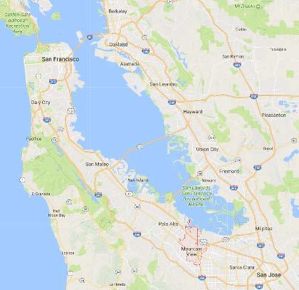
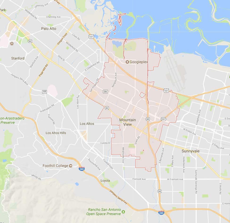
3 CITY OF MOUNTAIN VIEW Mountain View City: 12 square miles 75,000 residents Mountain View Watersheds: Urbanized watershed Permanente Creek Stevens Creek Adobe Creek (Palo Alto) San Francisco Bay 3

4 Shoreline Regional Park Community North Bayshore Area Palo Alto North Bayshore Area Mountain View Moffett Field NASA Ames Research Center 4
5 North Bayshore Area Water Bodies 5

6 North Bayshore Area Watershed Management Objectives Flood protection to businesses in North Bayshore Area 6

7 North Bayshore Area Watershed Management Objectives Landfill leachate collection for groundwater protection 7

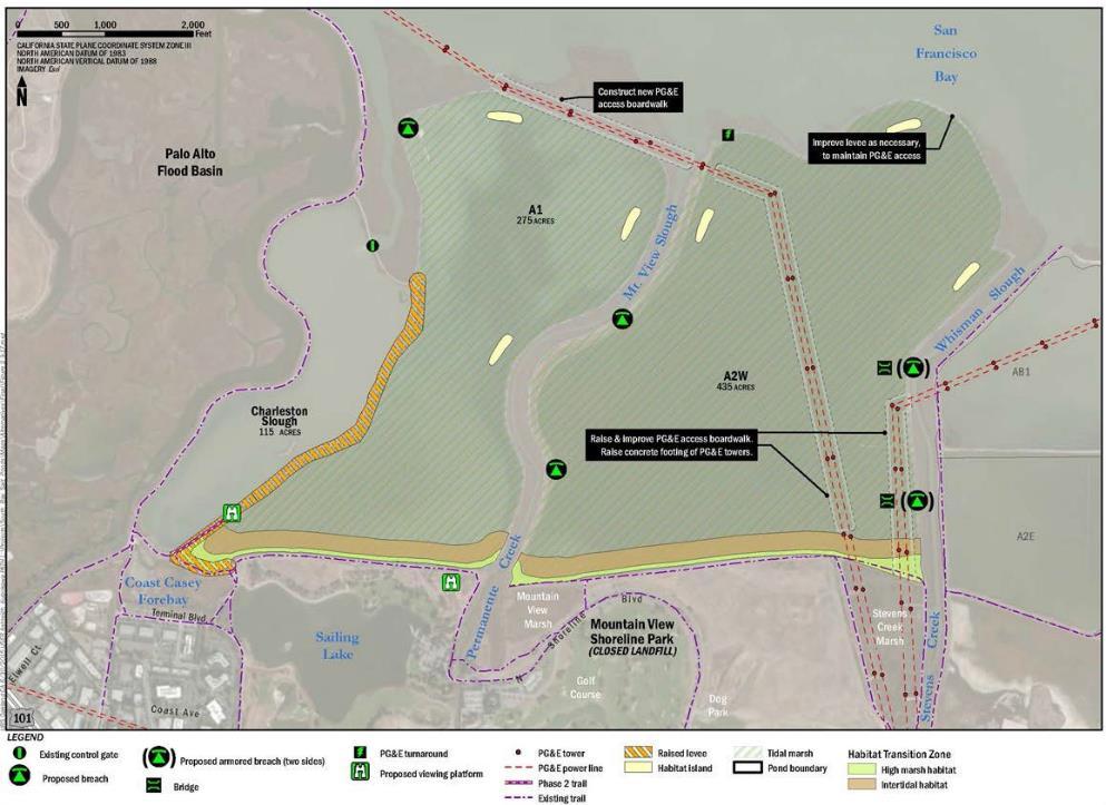
8 North Bayshore Area Watershed Management Objectives Tidal marsh and wetland management Charleston Slough Coast Casey Detention Basin Mountain View Tidal Marsh Stevens Creek Tidal Marsh 8

9 North Bayshore Area Watershed Management Objectives Tidal marsh and wetland management Charleston Slough City Management Objectives Compliance with BCDC tidal marsh restoration permit requirement Maintain water supply to Sailing Lake Flood protection for the City and Palo Alto Flood Basin Palo Alto Flood Basin Sailing Lake 9
10 North Bayshore Area Watershed Management Objectives Future coastal flood risk 10
11 Shoreline Sea Level Rise Study Prepare technical analysis to evaluate and map SLR flooding (geotechnical, coastal, creeks, interior drainage) Identify flood protection improvement projects Estimate project cost Develop Capital Program 11
12 Shoreline Sea Level Rise Study Study Results Level of Sea Level Rise (SLR) from 2000 to 2067 Low SLR = 8 inches (1% still water level = 11.3 NAVD) High SLR = 31 inches (1% still water level = 13.2 NAVD) Three levels of protection for each project Low SLR Low SLR Plus foundation for future High SLR project High SLR Capital Program with 12 projects CIP Cost = $43 $57 million 12
13 Shoreline Sea Level Rise Study Capital Program 1.Charleston Slough and Palo Alto Flood Basin Levee 2.Coast Casey North Levee 3.Landfill Erosion Protection 4.Lower Permanente Creek Levee and Floodwall 5.Golf Course Facilities High Ground Augmentation 6.Lower Stevens Creek Levee 7.Coast Casey Pump Station 8.Lower Permanente Creek Storm Drain 9.Sailing Lake Access Road 10.Sailing Lake Intake Pump Station Modification 11.Charleston Slough Tide Gates 12.Sea Level Rise Assessment 13


14 Implementation North Bayshore Precise Plan Land use planning considered future residual flood risk 14
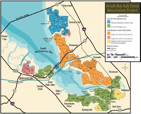

15 Implementation South Bay Salt Pond Restoration Project 15

16 Implementation South Bay Salt Pond Restoration Project (City, CSCC, USFWS) 10 Sailing Lake Pump Station 2 Coast Casey Levee Palo Alto Flood Basin 9 Sailing Lake Access Road Charleston Slough Sailing Lake 3 Erosion Protection Pond A1 Permanente Creek 3 Erosion Protection Pond A2W Stevens Creek 1.Charleston Slough and Palo Alto Flood Basin Levee 2.Coast Casey North Levee 3.Landfill Erosion Protection 4.Lower Permanente Creek Levee and Floodwall 5.Golf Course Facilities High Ground Augmentation 6.Lower Stevens Creek Levee 7.Coast Casey Pump Station 8.Lower Permanente Creek Storm Drain 9.Sailing Lake Access Road 10.Sailing Lake Intake Pump Station Modification 11.Charleston Slough Tide Gates 12.Sea Level Rise Assessment 16


17 Implementation Stevens Creek Levee Project (City, SCVWD) 1.Charleston Slough and Palo Alto Flood Basin Levee 2.Coast Casey North Levee 3.Landfill Erosion Protection 4.Lower Permanente Creek Levee and Floodwall 5.Golf Course Facilities High Ground Augmentation 6.Lower Stevens Creek Levee 7.Coast Casey Pump Station 8.Lower Permanente Creek Storm Drain 9.Sailing Lake Access Road 10.Sailing Lake Intake Pump Station Modification 11.Charleston Slough Tide Gates 12.Sea Level Rise Assessment 17


18 Implementation Permanente Creek Flood Protection Project (SCVWD) 1.Charleston Slough and Palo Alto Flood Basin Levee 2.Coast Casey North Levee 3.Landfill Erosion Protection 4.Lower Permanente Creek Levee and Floodwall 5.Golf Course Facilities High Ground Augmentation 6.Lower Stevens Creek Levee 7.Coast Casey Pump Station 8.Lower Permanente Creek Storm Drain 9.Sailing Lake Access Road 10.Sailing Lake Intake Pump Station Modification 11.Charleston Slough Tide Gates 12.Sea Level Rise Assessment 18


19 Implementation Charleston Slough Tidal Marsh Restoration (City) Restoration Water Supply Flood Protection 1.Charleston Slough and Palo Alto Flood Basin Levee 2.Coast Casey North Levee 3.Landfill Erosion Protection 4.Lower Permanente Creek Levee and Floodwall 5.Golf Course Facilities High Ground Augmentation 6.Lower Stevens Creek Levee 7.Coast Casey Pump Station 8.Lower Permanente Creek Storm Drain 9.Sailing Lake Access Road 10.Sailing Lake Intake Pump Station Modification 11.Charleston Slough Tide Gates 12.Sea Level Rise Assessment 19
20 Implementation Palo Alto Flood Basin (City, Palo Alto, SFCJPA, SCVWD) 1.Charleston Slough and Palo Alto Flood Basin Levee 2.Coast Casey North Levee 3.Landfill Erosion Protection 4.Lower Permanente Creek Levee and Floodwall 5.Golf Course Facilities High Ground Augmentation 6.Lower Stevens Creek Levee 7.Coast Casey Pump Station 8.Lower Permanente Creek Storm Drain 9.Sailing Lake Access Road 10.Sailing Lake Intake Pump Station Modification 11.Charleston Slough Tide Gates 12.Sea Level Rise Assessment 20

21 Shoreline Sea Level Rise Study Capital Program 1.Charleston Slough and Palo Alto Flood Basin Levee 2.Coast Casey North Levee 3.Landfill Erosion Protection 4.Lower Permanente Creek Levee and Floodwall 5.Golf Course Facilities High Ground Augmentation 6.Lower Stevens Creek Levee 7.Coast Casey Pump Station 8.Lower Permanente Creek Storm Drain 9.Sailing Lake Access Road 10.Sailing Lake Intake Pump Station Modification 11.Charleston Slough Tide Gates 12.Sea Level Rise Assessment 21
22 Upstream Watershed Management Objectives Urbanization encroachment into creek floodplains Capacity limitations in Permanente and Stevens Creek Lack of drainage system at the upper watershed Cross pipe (bubble up) system in downtown area Aging urban drainage system with capacity bottlenecks Water quality 22


23 Storm Water Master Plan Existing flood risk evaluation needs Green infrastructure Future vulnerability Detail creek analysis Interior drainage coupling Sea Level Rise scenarios Precipitation change scenarios 23

24 North Bayshore Area Water Bodies 24
25 Moving Forward Regional collaboration Sea Level Rise projection Policies Anticipated flood risk management needed vs funding How safe is safe enough: Manage residual flood risk 1.Charleston Slough and Palo Alto Flood Basin Levee 2.Coast Casey North Levee 3.Landfill Erosion Protection 4.Lower Permanente Creek Levee and Floodwall 5.Golf Course Facilities High Ground Augmentation 6.Lower Stevens Creek Levee 7.Coast Casey Pump Station 8.Lower Permanente Creek Storm Drain 9.Sailing Lake Access Road 10.Sailing Lake Intake Pump Station Modification 11.Charleston Slough Tide Gates 12.Sea Level Rise Assessment 25


26 Thank You! Contact Information Raymond Wong Lisa Au

27 City of Mountain View 27
28 City of Mountain View Supplemental Information 28
 Potential Palo Alto Flood Basin Levee Alternative Alignment (approx. 16,000 ) 11.")
29 Shoreline Sea Level Rise Study Detail CIP Project Maps 1. Charleston Slough and Palo Alto Flood Basin Levee (approx. 6,600 ) Potential Palo Alto Flood Basin Levee Alternative Alignment (approx. 16,000 ) 11. Charleston Slough Tide Gates Palo Alto Flood Basin Charleston Slough 29


30 Shoreline Sea Level Rise Study Detail CIP Project Maps 1. Charleston Slough and Palo Alto Flood Basin Levee 2. Coast Casey North Levee 7. Coast Casey Pump Station 9. Sailing Lake Access Road 10. Sailing Lake Intake Pump Station Modification 4. Lower Permanente Creek Levee and Floodwall 8. Lower Permanente Creek Storm Drain 30


31 Shoreline Sea Level Rise Study Detail CIP Project Maps 5. Golf Course Facilities High Ground Augmentation 6. Lower Stevens Creek Levee 31

32 Shoreline Sea Level Rise Study Flood Vulnerability 32


33 Project Implementation Timeline

34 Shoreline Sea Level Rise Study Comparison of SLR Projections

35 Shoreline Sea Level Rise Study Design Criteria Fluvial

36 Implementation Palo Alto Flood Basin (City, Palo Alto, SFCJPA, SCVWD) 1.Charleston Slough and Palo Alto Flood Basin Levee 2.Coast Casey North Levee 3.Landfill Erosion Protection 4.Lower Permanente Creek Levee and Floodwall 5.Golf Course Facilities High Ground Augmentation 6.Lower Stevens Creek Levee 7.Coast Casey Pump Station 8.Lower Permanente Creek Storm Drain 9.Sailing Lake Access Road 10.Sailing Lake Intake Pump Station Modification 11.Charleston Slough Tide Gates 12.Sea Level Rise Assessment 36
Preliminary Feasibility Study for South San Francisco Bay Shoreline Economic Impact Areas 1-10 Executive Summary
 Economic Impact Areas 1-10 Executive Summary Prepared For: Department of Water Resource Division of Flood Management State Of California Prepared By: Santa Clara Valley Water District February 2017 A preliminary
7/11/2018. Floodplain Management Association - June 14, 2018 luncheon
 7/11/2018 Floodplain Management Association - June 14, 2018 luncheon Len Materman Executive Director San Francisquito Creek Joint Powers Authority len@sfcjpa.org 650-324-1972 San Francisquito Creek 1998
SOUTH SAN FRANCISCO BAY SHORELINE STUDY SCOPING COMMENTS
 APPENDIX C SOUTH SAN FRANCISCO BAY SHORELINE STUDY SCOPING COMMENTS South Bay Salt Pond Restoration Project December 2007 Final Environmental Impact Statement/Report 1750.07 Appendix C Public Scoping Meeting
Integrating Sea Level Rise Considerations in the South Bay Salt Ponds Restoration Project. Norma J. Camacho Chief Operating Officer, Watersheds
 Integrating Sea Level Rise Considerations in the South Bay Salt Ponds Restoration Project Norma J. Camacho Chief Operating Officer, Watersheds Presentation Overview Mission of the District Santa Clara
Virginia Beach Comprehensive Sea Level Rise and Recurrent Flooding Planning Study
 1 Virginia Beach Comprehensive Sea Level Rise and Recurrent Flooding Planning Study Policy Recommendations and City-wide Flood Protection Strategies January 15, 2019 2 Agenda Project Overview Hazards and
Draft Environmental Impact Statement/ Report, Phase 2
 Draft Environmental Impact Statement/ Report, Phase 2 Executive Summary Photo Credit: Cris enton U.S. Fish and Wildlife Service / California State Coastal Conservancy This document contains the Executive
EXECUTIVE SUMMARY. S.1 Introduction
 EXECUTIVE SUMMARY S.1 Introduction This Draft Environmental Impact Statement/Environmental Impact Report (EIS/R) was prepared by the United States Fish and Wildlife Service (USFWS) and the California State
3.15 Utilities Physical Setting. Methodology
 This section of the Final Environmental Impact Statement/Report (referred to throughout as the Final EIS/R) describes the existing utilities within the Phase 2 project area and analyzes whether implementation
Appendix M. Summary of Local Sea Level Rise Planning Efforts. Draft
 Appendix M Summary of Local Sea Level Rise Planning Efforts Appendix M: Summary of Local Sea Level Rise Planning Efforts Summary of Local Sea Level Rise Planning Efforts Half Moon Bay SLR Planning Efforts
3.15 Utilities Physical Setting. Methodology
 This section of the Draft Environmental Impact Statement/Report (referred to throughout as the Draft EIS/R) describes the existing utilities within the Phase 2 project area and analyzes whether implementation
Draft Environmental Impact Report
 Revised Draft Environmental Impact Report San Francisquito Creek Flood Protection, Ecosystem Restoration, and Recreation Project Upstream of Highway 101 This notice announces that a Draft Environmental
Chapter 1 Introduction
 Chapter 1 Introduction 1.1 Background and Purpose This Stormwater Resource Plan (SWRP) is the result of a collaborative process between local and regional agencies to develop a comprehensive plan that
Sea Level Rise Impacts on Municipal Stormwater Systems in Hampton Roads
 VIRGINIA D.C. MARYLAND CHAPTER Sea Level Rise Impacts on Municipal Stormwater Systems in Hampton Roads Presentation at the APWA Mid-Atlantic Chapter May Regional Conference Virginia Beach, Virginia May
3.2 Hydrology, Flood Management, and Infrastructure
 This section of the Draft Environmental Impact Statement/Report (referred to throughout as the Draft EIS/R) characterizes the existing hydrology and flood management within the Phase 2 project area and
TOWN LINE BROOK URBAN WATERSHED STUDY MODELING INCREMENTAL IMPROVEMENTS
 TOWN LINE BROOK URBAN WATERSHED STUDY MODELING INCREMENTAL IMPROVEMENTS Marcus M. Quigley, P.E., Project Engineer, GeoSyntec Consultants Steven P. Roy, Associate, GeoSyntec Consultants Lawrence Gil, North
Flooding - Tidal and Rainfall. Presentation to City Council Informal Session May 24, John M. Keifer PE
 Flooding - Tidal and Rainfall Presentation to City Council Informal Session May 24, 2011 John M. Keifer PE Purpose of Presentation 1. Review flooding causes and implications to the City 2. Discuss mitigation
CITY OF NORFOLK COASTAL STORM RISK MANAGEMENT STUDY
 1 CITY OF NORFOLK COASTAL STORM RISK MANAGEMENT STUDY 255 255 255 File Name 237 237 237 217 217 217 200 200 200 0 0 0 163 163 163 131 132 122 239 65 53 80 119 27 252 174.59 110 135 120 112 92 56 62 102
Sea Level Rise Adaptation Strategy for San Diego Bay. Brian Holland, AICP, Climate Program Manager City of San Diego EESTF June 29, 2011
 Sea Level Rise Adaptation Strategy for San Diego Bay Brian Holland, AICP, Climate Program Manager City of San Diego EESTF June 29, 2011 Five Milestones for Climate Adaptation Adapted from Preparing for
M. Richard DeVoe. Elizabeth K. Fly, Ph.D.
 M. Richard DeVoe Executive Director Elizabeth K. Fly, Ph.D. Coastal Climate Extension Specialist Climate and Weather Weather: current state of the atmosphere (days-to-weeks) Hurricane Hugo Today s high
SAN FRANCISCO DISTRICT
 LETTER REPORT SAN FRANCISCO BAY SHORELINE STUDY U.S. ARMY CORPS OF ENGINEERS SAN FRANCISCO DISTRICT,APRIL 1992 LETTER REPORT SAN FRANCISCO BAY SHORELINE STUDY U.S. ARMY CORPS OF ENGINEERS SAN FRANCISCO
Appendix E. Civil Design and Cost Engineering
 Appendix E Civil Design and Cost Engineering Appendix E1 Civil Design Civil Design Appendix South San Francisco Bay Shoreline Study U.S. Army Corps of Engineers, San Francisco District September 2015 USACE
3.0 HYDROLOGIC AND HYDRAULIC CONDITIONS
 3.0 HYDROLOGIC AND HYDRAULIC CONDITIONS This chapter describes the existing hydrological resources within the project area, including the regional hydrology, project hydrology, and flood control benefits
Adapting to Rising Tides. Contra Costa County Sea Level Rise Vulnerability Assessment
 Adapting to Rising Tides Contra Costa County Sea Level Rise Vulnerability Assessment Final Report February 2016 Acknowledgments CONSULTANT TEAM: Michael Mak, Julie Guyenet, Mark Lightner, Justin Vandever,
Infrastructure Resiliency Planning & Strategy at the Municipal Level. Adapt, Thrive, and Survive Climate Impacts
 welcome Infrastructure Resiliency Planning & Strategy at the Municipal Level Adapt, Thrive, and Survive Climate Impacts Who we are Since 1899 Over 500 professionals 19 Office Locations on East Coast Three
San Francisco Bay Region
 LAURIE JOHNSON CONSULTING Resilient Coastal City Regions Urban Planning Risk Management Disaster Recovery Planning for Climate Change in the United States and Australia San Francisco Bay Region Laurie
Marin Countywide Sea Level Rise Planning
 Shoreline Highway at Highway Photo 101. Credit: Jeff Caltrans Wong Marin Countywide Sea Level Rise Planning B A Y W A V E A N D C S M A R T V U L N E R A B I L I T Y A S S E S S M E N T S Tidal Flooding
The newly updated and comprehensive SWMP shall:
 RFQ SCOPE OF SERVICES 2.1 Project Purpose The City of Miami, ( City ) is seeking professional engineering services from a qualified firm for the purpose of planning and developing a newly updated and comprehensive
Implications of Sea Level Rise: Case Study on the East Land Bridge Ben C. Gerwick, Inc.
 Implications of Sea Level Rise: Case Study on the East Land Bridge Ben C. Gerwick, Inc. 1 APRIL 16, 2013 COWI POWERPOINT PRESENTATION SLR Contributions to 2004 NOAA 2012 Global Sea Level Rise Scenarios
APPENDIX B ALTERNATIVES DEVELOPMENT, SCREENING, AND ANALYSIS
 APPENDIX B ALTERNATIVES DEVELOPMENT, SCREENING, AND ANALYSIS Draft Environmental Impact Statement/Report i Modified May 2015 DRAFT Appendix B This page intentionally left blank Draft Environmental Impact
PRINCESS ANNE DISTRICT STORMWATER PROJECTS
 PRINCESS ANNE DISTRICT STORMWATER PROJECTS Topics o o o o o Sea Level Rise and the Southern Watersheds Ashville Park Sherwood Lakes Kingston Estates Drainage Operations & Maintenance in the Southern Watersheds
The success of Gwinnett County s Floodplain Management Program can be directly attributed to Dewberry s innovation and quality.
 Water Resources With severe storms, droughts, and ever-expanding urban centers, water resources issues have become increasingly complex. We work with our clients to find innovative and cost-effective solutions
NOVATO FLOOD CONTROL ZONE No. 1 Marin County Flood Control and Water Conservation District
 NOVATO FLOOD CONTROL ZONE No. 1 Marin County Flood Control and Water Conservation District Photo by R. Tong. Marin IJ INFORMATION ON MEASURE E: NOVEMBER 7, 2017 PARCEL TAX MEASURE PRESENTATION TO NOVATO
Funding a More Holistic Effort - Bringing In New Partners and Resources Case Study: San Mateo County Shoreline Vulnerability Assessment
 Funding a More Holistic Effort - Bringing In New Partners and Resources Case Study: San Mateo County Shoreline Vulnerability Assessment Craig Conner Flood Risk Management Program Manager 3 December 2015
4.8 HYDROLOGY AND WATER QUALITY
 4.8 HYDROLOGY AND WATER QUALITY INTRODUCTION This section provides a discussion of existing conditions related to climate, water resources, hydrology, and water quality within the vicinity of the project
Adapting to Rising Tides
 Adapting to Rising Tides A regional program that uses findings, processes, tools and relationships built by ART and its partners to lead and support efforts that increase the resilience of San Francisco
City of Madison: 2017 Capital Budget Capital Improvement Plan
 City of Madison: 2017 Capital Budget Capital Improvement Plan Agency: Stormwater Utility Project Summary Backyard Drainage Problems 25,000 25,000 25,000 25,000 25,000 25,000 CIPP Lining Storm Sewer 100,000
Living On The Edge: implications of growth and development on watersheds in the Charleston region
 Living On The Edge: implications of growth and development on watersheds in the Charleston region Norman S. Levine - Department of Geology, May 17, 2018 Director: Lowcountry Hazard Center & Santee Cooper
Tidal Wetlands and Climate Adaptation Moving to Actionable Smart Assessment
 Siegel, Sep 2016, 1 Tidal Wetlands and Climate Adaptation Moving to Actionable Smart Assessment Stuart Siegel, PhD, PWS San Francisco Bay National Estuarine Research Reserve Department of Earth and Climate
Project Summary
 Stormwater Utility Capital Improvement Plan Project Summary 2017 2018 2019 2020 2021 2022 Backyard Drainage Problems 25,000 25,000 25,000 25,000 25,000 25,000 CIPP Lining Storm Sewer 100,000 100,000 100,000
California Regional Water Quality Control Board San Francisco Bay Region. Tentative Order No. R XXXX
 California Regional Water Quality Control Board San Francisco Bay Region Amending Waste Discharge Requirements Order No. R2-2008-0078 for: U.S. Fish and Wildlife Service and California Department of Fish
5/25/2017. Overview. Project Background Information. Project Background Information Modeling Approach Model Development Results Next Steps
 City of Corpus Christi Downtown 2D Mapping Effort Brandon Hilbrich, PE, CFM Jake Fisher, PE, CFM Curtis Beitel, PE, CFM 2016 HDR, Inc., all rights reserved. Overview Project Background Information Modeling
DRAINAGE AND NATURAL AQUIFER GROUNDWATER RECHARGE ELEMENT
 Goal 7.0. To optimize integrated stormwater management in order to reduce damage and impacts from sea level rise and flooding, promotes recharge to the Surficial Aquifer System (SAS), improve and protect
Everglades Restoration Climate Program
 Sea Level Change and Long Range Water Resources Planning for Florida Everglades Restoration Climate Program Change Application Concerns of USACE and Guidance Draft Sea Level on Sea Rise Level Planning
Water resources planning for Broward county in response to climate change
 Water resources planning for Broward county in response to climate change Broward County Environmental Planning & Community Resilience -Samantha Danchuk, PhD, PE March 18, 2015 South Florida Hydrologic
THUNDER BAY AREA DRAINAGE MASTER PLAN
 THUNDER BAY AREA DRAINAGE MASTER PLAN Overall problem Vs. local solutions There are several areas with local flooding problems A review of the situation showed that the problem is not local, but that the
Chapter 3 Previous Studies
 Chapter 3 Previous Studies The Vista Grande stormwater conveyance system and watershed area has been evaluated in a number of reports and studies for the CCSF, the Daly City and San Mateo County over the
A Salt Marsh Advancement Zone Assessment of West Haven, Connecticut
 A Salt Marsh Advancement Zone Assessment of West Haven, Connecticut Front cover image: Open space and unprotected parcels critical to the conservation of marsh advancement corridors in West Haven; from
SAN MATEO COUNTY SEA LEVEL RISE INITIATIVE PAC AND TWG MEETING // APRIL 18, 2017
 SAN MATEO COUNTY SEA LEVEL RISE INITIATIVE PAC AND TWG MEETING // APRIL 18, 2017 PRESENTATION GOALS Provide an overview of: Sea Change SMC Initiative Draft sea level rise vulnerability assessment results
2016 Annual Self-Monitoring Report Don Edwards San Francisco Bay National Wildlife Refuge Fremont, California
 2016 Annual Self-Monitoring Report Don Edwards San Francisco Bay National Wildlife Refuge Fremont, California Prepared for: California Regional Water Quality Control Board San Francisco Bay Region 1515
Exposure Analysis. This guide helps with. Definition: Exposure ADAPTING TO RISING TIDES PROGRAM. Climate Impacts
 ART SUPPLY: HOW-TO GUIDE Design Your Project Steps 2 & 3: Choose an Approach & Do the Assessment Exposure Analysis ADAPTING TO RISING TIDES PROGRAM This guide helps with Conducting an efficient and effective
Physical & Program Options for Inland Migration of Louisiana s Coastal Wetlands
 Physical & Program Options for Inland Migration of Louisiana s Coastal Wetlands Melissa Kemm & Sam Pardo Duke University Nicholas School of the Environment Client: Louisiana Coastal Protection & Restoration
A Salt Marsh Advancement Zone Assessment of Stamford, Connecticut
 A Salt Marsh Advancement Zone Assessment of Stamford, Connecticut Front cover image: Open space and unprotected parcels critical to the conservation of marsh advancement corridors in Stamford; from the
Protecting and Restoring Habitat (Fact Sheet)
") University of Southern Maine USM Digital Commons Publications Casco Bay Estuary Partnership (CBEP) 2014 Protecting and Restoring Habitat (Fact Sheet) Casco Bay Estuary Partnership Follow this and additional
University of Southern Maine USM Digital Commons Publications Casco Bay Estuary Partnership (CBEP) 2014 Protecting and Restoring Habitat (Fact Sheet) Casco Bay Estuary Partnership Follow this and additional
Rainy Season Preparation & Storm Channel Maintenance
 Rainy Season Preparation & Storm Channel Maintenance City Efforts Thorough Review of the storm water system Documentation of system conditions Now part of selection criteria or maintenance Full public
WATERSHED MANAGEMENT INITIATIVE: GOALS & IMPLEMENTATION OBJECTIVES, JULY 26, 1999
 WATERSHED MANAGEMENT INITIATIVE: GOALS & IMPLEMENTATION OBJECTIVES, JULY 26, 1999 The following table indicates the draft goals and objectives for the Santa Clara Basin WMI process. The overall objectives
NOVATO WATERSHED PROGRAM
 NOVATO WATERSHED PROGRAM NOVATO CITY COUNCIL Photo Credit: Sue Lattanzio AGENDA OVERVIEW OF TONIGHT S TALK Slide 2 Context what is a watershed? Process how did we implement the watershed approach? Content
FROM TIDES TO STORMS: PREPARING FOR NEW HAMPSHIRE S FUTURE COAST
 FROM TIDES TO STORMS: PREPARING FOR NEW HAMPSHIRE S FUTURE COAST Seabrook - Hampton Falls Hampton - North Hampton Rye - New Castle - Portsmouth Assessing the Risk and Vulnerability of NH Coastal Communities
Lessons [being] learnt 2016 Flood in Cedar Rapids. Sandy Pumphrey Project Engineer II Flood Mitigation
![Lessons [being] learnt 2016 Flood in Cedar Rapids. Sandy Pumphrey Project Engineer II Flood Mitigation](/thumbs/77/74998790.jpg "Lessons [being] learnt 2016 Flood in Cedar Rapids. Sandy Pumphrey Project Engineer II Flood Mitigation") Lessons [being] learnt 2016 Flood in Cedar Rapids Sandy Pumphrey Project Engineer II Flood Mitigation 319 286 5363 s.pumphrey@cedar-rapids.org Agenda 2008 Flood Event 2016 Flood Event [Long Term] Flood
Lessons [being] learnt 2016 Flood in Cedar Rapids Sandy Pumphrey Project Engineer II Flood Mitigation 319 286 5363 s.pumphrey@cedar-rapids.org Agenda 2008 Flood Event 2016 Flood Event [Long Term] Flood
A Salt Marsh Advancement Zone Assessment of Darien, Connecticut
 A Salt Marsh Advancement Zone Assessment of Darien, Connecticut Front cover image: Open space and unprotected parcels critical to the conservation of marsh advancement corridors in Darien; from the accompanying
SAN FRANCISCO DISTRICT TRAVIS J. RAYFIELD, PE, PMP LIEUTENANT COLONEL, US ARMY DISTRICT COMMANDER/ENGINEER
 SAN FRANCISCO DISTRICT 1 ENGINEERING WITH NATURE SYMPOSIUM UC SANTA CRUZ 237 217 200 80 NATURAL 237 AND 217 NATURE 200 BASED 119 237 217 200 27 FEATURES 252 174.59 255 255 255 0 0 0 163 163 163 131 132
ACKNOWLEDGEMENTS. Sincerely, Executive Director and Staff. Rockingham Planning Commission. 156 Water Street Exeter, NH (603)
") ACKNOWLEDGEMENTS The gratefully acknowledges the participation of coastal New Hampshire municipalities in the preparation of this report: City of Portsmouth Town of New Castle Town of Rye Town of North
ACKNOWLEDGEMENTS The gratefully acknowledges the participation of coastal New Hampshire municipalities in the preparation of this report: City of Portsmouth Town of New Castle Town of Rye Town of North
STORM WATER and LID SESSION
 STORM WATER and LID SESSION STORM WATER & LID SESSION SESSION LINEUP NEDES Overview Patrick Bryan Environmental Resources Technician, Fresno Metropolitan Flood Control District Local Prospective Gene Matters
acquiring, managing, and disposing of federal lands and facilities;
 2.2.1 HYDROLOGY AND FLOODPLAIN This section discusses and analyzes the surface hydrology and water quality characteristics of the project. The information provided in this section is based on the Preliminary
3.15 Utilities Physical Setting. Methodology
 3.15 Utilities This section of the Draft Environmental Impact Statement/Report (EIS/R) describes the existing utilities within the Eden Landing Phase 2 project area and analyzes whether implementation
TAMPA BAY COASTAL HABITATS: CLIMATE CHANGE POTENTIAL IMPACTS & MANAGEMENT FOR THE FUTURE
 TAMPA BAY COASTAL HABITATS: CLIMATE CHANGE POTENTIAL IMPACTS & MANAGEMENT FOR THE FUTURE Ed Sherwood Tampa Bay Estuary Program 263 13 th Ave. South St. Petersburg, FL 33701 esherwood@tbep.org http://www.tbep.org
Adapting to Rising Tides
 Adapting to Rising Tides Getting to Flood Resilience through Collaborative Planning and Capacity Building San Francisco Bay Conservation and Development Commission www.adaptingtorisingtides.org Wendy Goodfriend,
Turning the Tide. David Sanger
 Turning the Tide David Sanger 1 2 David Sanger 3 Why Restore the South Bay? Docent-led Interpretive Tour 1983 Alviso Floods Least Sandpipers 4 Presentation Overview Background Acquisition of salt ponds
SILICON VALLEY 2.0 SPUR. County of Santa Clara Office of Sustainability
 SILICON VALLEY 2.0 SPUR 22-SEPT-2015 County of Santa Clara Office of Sustainability # WHY NOW? THE 4 FAULTY PRESUMPTIONS OF ADAPTATION It is too speculative It is too far away It has no present Event benefits
Manchester-by-the-Sea
 Manchester-by-the-Sea A Community Plans for Coastal Resilience Finding Solutions to our Coastal Challenges Salem Sound Coastwatch 25 th Anniversary Symposium March 18, 2016 Janet Moonan, P.E., Project
Review Budget and Timeline for XP-SWMM Phase II Project and Determine Next Steps
 Memorandum To: Item 5C - Review Budget and Timeline for XP-SWMM Phase II Project and Determine Next Steps Project: 23/27-0051 2015 5C Review Budget and Timeline for XP-SWMM Phase II Project and Determine
A Salt Marsh Advancement Zone Assessment of Norwalk, Connecticut
 A Salt Marsh Advancement Zone Assessment of Norwalk, Connecticut Front cover image: Open space and unprotected parcels critical to the conservation of marsh advancement corridors in Norwalk; from the accompanying
Bee Branch Restoration Alignment Study
 Bee Branch Restoration Alignment Study Bee Branch Citizen Advisory Committee (BBCAC) Meeting # 2 December 4, 2003 Meeting Agenda Introduction Project Objectives and Project Opportunities Model Validation
10. INDEX. South Bay Salt Pond Restoration Project December 2007 Final Environmental Impact Statement/Report
 10. INDEX A Adaptive management, ES-4, ES-17, ES-18, ES-20, ES-54, ES-55, ES-56, 1-23, 3.1-5, 3.1-6, 3.3-45, 3.3-51, 3.3-52, 3.3-53, 3.3-55, 3.3-64, 3.3-65, 3.3-71, 3.4-25, 3.4-30, 3.4-45, 3.4-56, 3.4-58,
SILVER SPRINGS/RIVER POLLUTION REDUCTION PROJECT IMPROVING THE WATER QUALITY OF THE SILVER SPRINGS ECOSYSTEM
 SILVER SPRINGS/RIVER POLLUTION REDUCTION PROJECT IMPROVING THE WATER QUALITY OF THE SILVER SPRINGS ECOSYSTEM Jonathan Steflik, PE JEA (Formerly Black & Veatch) Bruce Phillips, PE PLS, Tom Young, PE City
Regional Approaches to Resiliency
 Regional Approaches to Resiliency Addressing the Impacts of Sea Level Rise COJ Environmental Symposium September 9, 2016 Danielle H. Irwin, PWS, LEED AP Globally, the sea is expected to rise 1 4 by 2100;
Flood Risk Management in Halifax Regional Municipality. Shannon Miedema, Energy & Environment
 Flood Risk Management in Halifax Regional Municipality Shannon Miedema, Energy & Environment Flood Risk Management in Canada s Coastal Regions June 13, 2018 HRM Energy & Environment Sea Level Rise Coastal
SURREY COASTAL FLOOD ADAPTATION STRATEGY (CFAS) General Phase 1 Workshop Presentation (February 3 through March 8, 2017)
 General Phase 1 Workshop Presentation (February 3 through March 8, 2017)") SURREY COASTAL FLOOD ADAPTATION STRATEGY (CFAS) General Phase 1 Workshop Presentation (February 3 through March 8, 2017) Agenda Introductions and Overview Project Overview Activity 1 Hazards BREAK Activity
SURREY COASTAL FLOOD ADAPTATION STRATEGY (CFAS) General Phase 1 Workshop Presentation (February 3 through March 8, 2017) Agenda Introductions and Overview Project Overview Activity 1 Hazards BREAK Activity
SAN BRUNO CREEK / COLMA CREEK RESILIENCY STUDY FINAL REPORT
 SAN BRUNO CREEK / COLMA CREEK RESILIENCY STUDY FINAL REPORT Prepared for: San Francisco International Airport RFP: 8354.1 Prepared by: August 2015 M&N Job No: 7981 Final Report Page E-1 EXECUTIVE SUMMARY
QUARTERLY STORMWATER UPDATE FLOOD CONTROL PROJECTS TONI ALGER, P.E. STORMWATER ENGINEERING CENTER ADMINISTRATOR MARCH 27, 2018
 QUARTERLY STORMWATER UPDATE FLOOD CONTROL PROJECTS TONI ALGER, P.E. STORMWATER ENGINEERING CENTER ADMINISTRATOR MARCH 27, 2018 Aragona Drainage Improvements D A S H B O A R D Ashville Park Drainage Improvements
APPENDIX A-1. SECTOR PROFILE RESULTS
 References APPENDIX A-1. SECTOR PROFILE RESULTS This Appendix summarizes the effects of 8 inches, 16 inches and 58 inches (about 5 feet) of sea level rise (SLR) on routine monthly high tide inundation
Type of Problem. All existing and anticipated future problems/concerns. Building Flooding Drainage Issue Street Flooding Restrictive Structure
 Jeffersonville Stormwater Master Plan (SWMP) Advisory Committee Meeting Worksheet (1/10/12) SUMMARY OF SUGGESTED TARGET STUDY AREAS & PROMISING SOLUTIONS FOR EVALUATION IN PHASE 2 Problem Area Name 1 Existing
RUBONIA SUBDIVISION DRAINAGE AND ROADWAY IMPROVMENTS PREPARED BY: MANATEE COUNTY PUBLIC WORKS ENGINEERING SERVICES DIVISION
 RUBONIA SUBDIVISION DRAINAGE AND ROADWAY IMPROVMENTS PREPARED BY: MANATEE COUNTY PUBLIC WORKS ENGINEERING SERVICES DIVISION OCTOBER 7, 2016 1 INTRODUCTION Rubonia Neighborhood (Rubonia) is located in northern
QUARTERLY STORMWATER UPDATE FLOOD CONTROL PROJECTS TONI ALGER, P.E. CITY ENGINEER S OFFICE/STORMWATER ENGINEERING CENTER DECEMBER 12, 2017
 QUARTERLY STORMWATER UPDATE FLOOD CONTROL PROJECTS TONI ALGER, P.E. CITY ENGINEER S OFFICE/STORMWATER ENGINEERING CENTER DECEMBER 12, 2017 D A S H B O A R D Aragona Drainage Improvements Ashville Park
Municipal Stormwater Management Plan Prepared For The Borough of Cape May Point By Van Note-Harvey Associates VNH File No.
 Municipal Stormwater Management Plan Prepared For The Borough of Cape May Point By Van Note-Harvey Associates 2005 VNH File No. 35317-210-21 Table of Contents Introduction... 3 Goals... 3 Storm water Discussion...
ART Vulnerability and Risk Assessment Report September 2012
 Chapter 13. Stormwater Management Stormwater runoff is generated when rain or snowmelt flows over land or impervious surfaces and does not infiltrate into the ground. Stormwater infrastructure consists
San Mateo Plain Groundwater Basin Assessment Stakeholder Workshop #8 17 APRIL 2018
 San Mateo Plain Groundwater Basin Assessment Stakeholder Workshop #8 17 APRIL 2018 PRESENTATION OVERVIEW Introductions Project Overview Summary of Analysis Supporting Model Development Model Development
Westminster East Garden Grove, California Flood Risk Management Feasibility Study
 1 Public Scoping Meeting Westminster East Garden Grove, California 255 255 255 237 237 237 217 217 217 200 200 200 0 0 0 163 163 163 131 132 122 239 65 53 80 119 27 252 174.59 110 135 120 112 92 56 62
Stemming the Tide: Stakeholder-driven adaptation planning in South Carolina. Liz Fly, Ph.D. Coastal Climate Extension Specialist
 Stemming the Tide: Stakeholder-driven adaptation planning in South Carolina Liz Fly, Ph.D. Coastal Climate Extension Specialist South Carolina 2,876 miles of tidal shoreline 20% of total salt marsh area
WHO WE ARE OUR SERVICES. Since 1899 Over 500 professionals 16 Office Locations on East Coast Three companies
 WHO WE ARE OUR SERVICES Since 1899 Over 500 professionals 16 Office Locations on East Coast Three companies Water Wastewater MEP/SCADA Stormwater Climate Resiliency Architecture Landscape Architecture
Black Duck Logic Table and Work Plan ( ) Factor Current Efforts Gap Actions (critical actions in bold) Expected Response and Application
 Factor Current Efforts Gap Actions (critical actions in bold) Expected Response and Application") Black Duck Logic Table and Work Plan (2018-2020) Long-term Target: (the metric for success of Outcome): By 2025, restore, enhance, and preserve wetland habitats that support a wintering population of 100,000
Black Duck Logic Table and Work Plan (2018-2020) Long-term Target: (the metric for success of Outcome): By 2025, restore, enhance, and preserve wetland habitats that support a wintering population of 100,000
Our A Team APDS Contracting
 1 Our A Team APDS Contracting 2 Definition of the Problem 3 Canal Importation Basin 4 Existing Floodplain 5 Development by Decades 6 Contributing Factors to Flooding Historic streams obliterated by irrigation
A Salt Marsh Advancement Zone Assessment of Clinton, Connecticut
 A Salt Marsh Advancement Zone Assessment of Clinton, Connecticut Front cover image: Open space and unprotected parcels critical to the conservation of marsh advancement corridors in Clinton; from the accompanying
Appendix H: Climate Change Vulnerability Question Worksheet
 Appendix H: Climate Change Vulnerability Question Worksheet Page Intentionally Left Blank Water Demand Vulnerability / Justification Vulnerability Issue Comments Are there major industries that require
PROPOSED STORMWATER PROJECT IMPLEMENTATION PLAN. o Execution of New and Expanded Flood Control Projects o Program Options
 PROPOSED STORMWATER PROJECT IMPLEMENTATION PLAN o Execution of New and Expanded Flood Control Projects o Program Options PHILLIP A. DAVENPORT DIRECTOR OF PUBLIC WORKS APRIL 25, 2017 FLOOD CONTROL PROJECTS
Hydromodification Management Measures
 Chapter 7 Hydromodification Management Measures This Chapter summarizes the requirements for controlling erosive flows from development projects. 7.1 Why Require Hydromodification Management? Changes in
Hydromodification Management Measures
 Chapter 7 Hydromodification Management Measures This Chapter summarizes the requirements for controlling erosive flows from development projects. 7.1 Why Require Hydromodification Management? Changes in
One Foot Out of the Bathtub Sea Level Rise Modeling Solutions
 One Foot Out of the Bathtub Sea Level Rise Modeling Solutions Brian Caufield, P.E., CFM Principal Coastal Engineer Mark Zito, GISP, CFM GIS Specialist/Local Team Leader April 1, 2015 Outline Coastal GeoTools
HMP 101 Hydromodification Management Plan for Santa Clara Valley Guidance for Local Implementation
 HMP 101 Hydromodification Management Plan for Santa Clara Valley Guidance for Local Implementation Jill C. Bicknell, P.E., EOA, Inc. Assistant Program Manager EOA, Inc. GeoSyntec Consultants Presentation
The 9th Disaster Risk Management Seminar
 The 9th Disaster Risk Management Seminar "Integrated Urban Flood Risk Management: Obstacles and Opportunities in East Asia-Pacific and Lessons from Japan" INSTITUTIONAL FRAMEWORK, CHALLENGES IN VIETNAM
Phase II: Construction (See Appendix 1 for figures and photos)
") Phase I- Complete: Plan Design, Compliance and Baseline Monitoring Audubon and San Pablo Bay National Wildlife Refuge (Refuge) staff completed approximately 2 years of pre-construction monitoring including
Phase I- Complete: Plan Design, Compliance and Baseline Monitoring Audubon and San Pablo Bay National Wildlife Refuge (Refuge) staff completed approximately 2 years of pre-construction monitoring including