Scoping Document. Precious Minerals Mining and Refining Corporation East Walker Clay Mine Expansion Project Lyon County, Nevada
|
|
|
- David Hopkins
- 6 years ago
- Views:
Transcription
1 Scoping Document Precious Minerals Mining and Refining Corporation East Walker Clay Mine Expansion Project Lyon County, Nevada United States Department of Agriculture Forest Service USDA Forest Service Humboldt-Toiyabe National Forest Bridgeport Ranger District Bridgeport, California April 2012
2 The U.S. Department of Agriculture (USDA) prohibits discrimination in all its programs and activities on the basis of race, color, national origin, gender, religion, age, disability, political beliefs, sexual orientation, or marital or family status. (Not all prohibited bases apply to all programs.) Persons with disabilities who require alternative means for communication of program information (Braille, large print, audiotape, etc.) should contact USDA's TARGET Center at (202) (voice and TDD). To file a complaint of discrimination, write USDA, Director, Office of Civil Rights, Room 326-W, Whitten Building, 14th and Independence Avenue, SW, Washington, DC or call (202) (voice and TDD). USDA is an equal opportunity provider and employer. 2
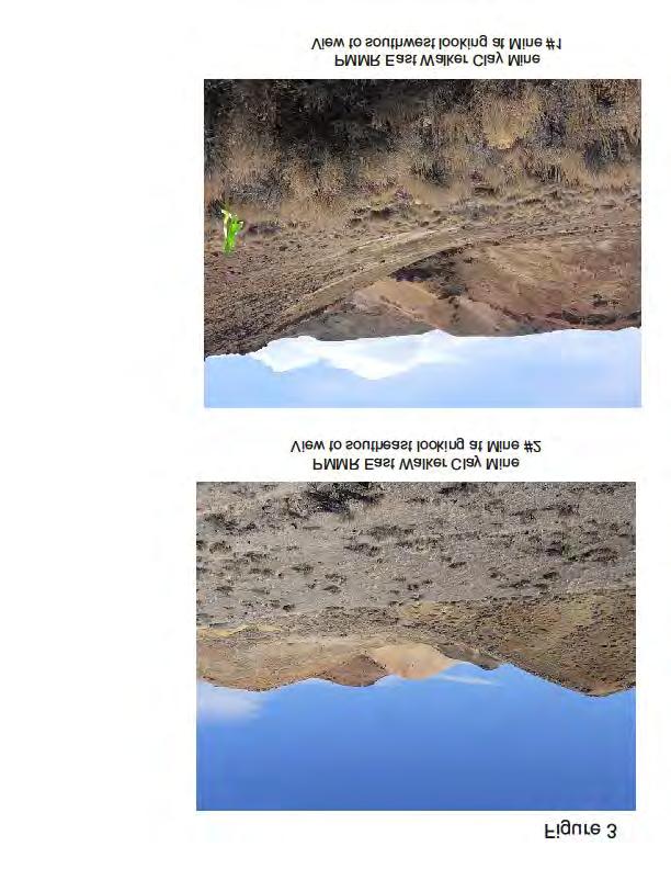
3 Table of Contents 1. COMMENTS WELCOME LOCATION PURPOSE OF AND NEED FOR ACTION DECISION FRAMEWORK THE PROPOSED ACTION ENVIRONMENTAL PROTECTION MEASURES MONITORING PRELIMINARY ISSUES ALTERNATIVES COMMENT PROCESS ANALYSIS PROCESS CONTACT Attachments Figure 1: Project Location Figure 2: Proposed Disturbance Figure 3: Photographs Figure 4: Photographs 3
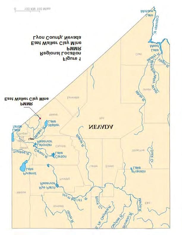
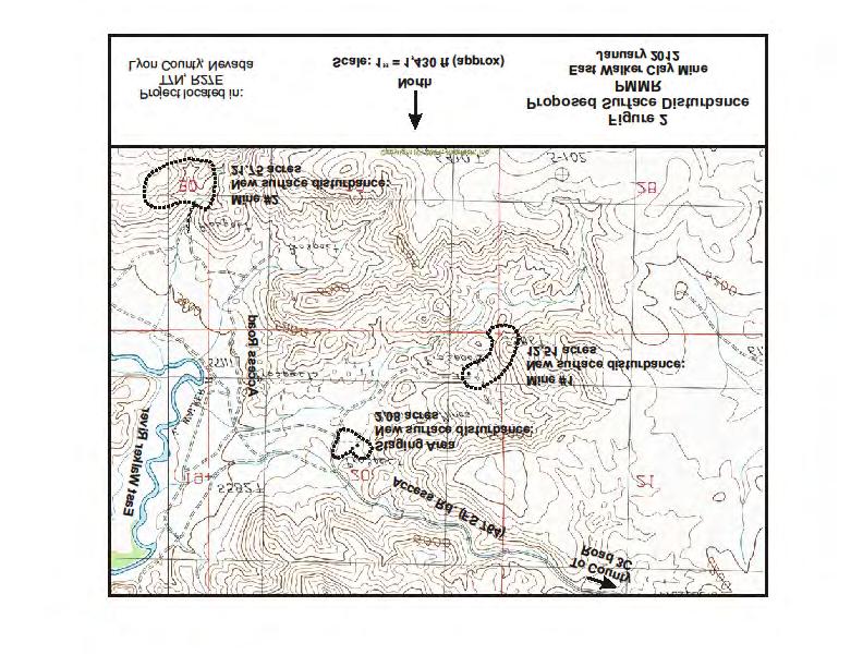
4 1. Comments Welcome The Bridgeport Ranger District of the Humboldt-Toiyabe National Forest welcomes your comments on the East Walker Clay Mine Expansion Project (Project) proposed by the Precious Minerals Mining and Refining Corporation (PMMR). The Project would consist of: minor improvements to existing Forest Service roads; surface mining disturbance; construction of a mine staging area, and surface water de-siltation ponds. Total Project-related disturbance would be up to approximately 45.8 acres. PMMR would use four Forest Service Roads, 764, 765, 765A, and 765B, to access the mine site for all mine-related traffic including over-the-road haul trucks which would transport the extracted mineral deposit to a rail road loading facility near Wabuska in Lyon County. The Forest Service is conducting an environmental analysis of the proposal in accordance with the National Environmental Policy Act of 1969 (as amended) (NEPA). As part of this analysis, the Forest Service is now seeking public comments specific to the proposed Project. The purpose of the scoping period is to identify the public's and agency concerns and clearly define the environmental issues regarding the proposal in accordance with the requirements of the NEPA. 2. Location The Project would be located on National Forest System lands in Lyon County, Nevada, within the Humboldt-Toiyabe National Forest, which is administered by the U.S. Department of Agriculture, Forest Service, Bridgeport Ranger District. The East Walker Clay Mine is located approximately 17 miles northeast of Bridgeport, California and 21 miles west-southwest of Hawthorne, Nevada in southern Lyon County, Nevada as shown on Figure 1. The mine site is located in the Pine Grove Hills, east of the East Walker River (Figure 2) and is entirely on public lands within the boundaries of the Humboldt-Toiyabe National Forest. The proposed Project area encompasses approximately acres, which includes approximately acres of new surface disturbance. The Project is located within: Mine locations: Township 7 North, Range 27 East, portions of Sections 20, 21, 28, 29 and 30 (Lyon County, Nevada); Access Locations: Township 7 North, Range 27 East, portions of Sections 11, 12, 14, 15, 16, 20, 21, 29 and 30 (Lyon County, Nevada). The general location of the Project is illustrated on Figure 1, with access routes presented on Figure 2. Primary access would be south from the City of Yerington, Nevada via Lyon County Road 3C, to existing Forest Service System Roads 764, 765, 765A, and 765B. The mine development equipment (including over-the -road materials haul trucks, service trucks, and pickup trucks) would use this route to access the proposed Project. 3. Purpose Of and Need for Action The purpose of and need for the Project is to extract economic mineral deposits on National Forest System lands in the Project area. The statutory right of PMMR to develop mineral resources on federally-administered lands is recognized in the General Mining Law of 1872, and is consistent with the Humboldt-Toiyabe National Forest Land and Resources Management Plan of 1986 (IV-50). Surface management regulations (36 CFR 228) require that all mineral exploration, development, and operation activities be conducted in a manner that minimizes adverse environmental impacts on National Forest surface resources (36 CFR 228.8). 4
5 4. Decision Framework Based on the environmental analysis and disclosure documented in the Environmental Assessment (EA) currently being prepared, the Deciding Official would decide: 1) whether to select the Proposed Action as proposed or modified, or as described in an alternative; 2) what mitigation measures may be needed; and 3) what monitoring is required. 5. The Proposed Action Background In 1998, the U.S. Forest Service issued PMMR an approved Mining Plan of Operations for the East Walker Clay Mine. After preparing an Environmental Assessment, on July 9, 1998, the Forest Service issued a Decision Notice/Finding of No Significant Impact (DN/FONSI) for the PMMR Mining Plan of Operations # The approval allows for the removal of an economic mineral from Mine #2. Under the Small Mine Operations Permit, PMMR may remove a maximum of 36,500 tons of material annually. To date, PMMR has extracted approximately 5,000 tons of material under their existing mining permits. PMMR now proposes to expand operations to include two mine sites: expansion of the existing approved site and an additional new mine site plus a staging area. The proposed action includes a year around operation to annually extract approximately 750,000 cubic yards (1,000,000 metric tons) from two surface mines. The economic deposit, a clay-based mineral, will be mined from the surface, crushed and partially dried on-site before being loaded into haul trucks which will transport the material to a rail siding near Wabuska, Nevada for distribution to markets. PMMR anticipates that the mine will have an economic life of ten (10) years. In 1999, PMMR received approvals for a Plan of Operations and Reclamation Plan from the State of Nevada, Department of Environmental Protection, Bureau of Mining Regulation and Reclamation, for extraction of a maximum of 36,500 tons of clay-based material annually. Use of Existing Roads Approximately 6.6 miles of existing Forest Service roads (Forest roads 764, 765, 765A, and 765B) would be used for all mine-related traffic, including 140 round trips per day based on an estimated 300 working days per year for the over-the-road haul trucks that will carry the extracted minerals to a rail siding and loading facility north of Yerington, Nevada. Mineral Extraction The economic material will be excavated, partially dried and hauled to a rail siding. The resource will be processed through a portable crusher, screen, dryer and conveyor belt for off-haul to a rail siding near Wabuska for shipment. No chemical processing is used in the mineral processing. Equipment Mechanized equipment proposed for the project includes: Dozers-Cat D10R or equivalent Front end loaders-cat 988G or equivalent Motor graders-cat 14G or equivalent End dump-24 ton capacity Water Trucks-3500 gallon capacity Excavators-Cat 350 or equivalent 5
6 Trucks (mineral haul)-double trailer Crushers and screens-lokotrak LT-150 tons per hour capacity, one at each mine site Portable propane-fueled dryers Overall Disturbance Disturbance has been calculated to include mine areas, minor road improvements and mine staging area as shown in Figure 2. The total anticipated new surface disturbance for this project would be approximately acres which includes: Approximately 5.40 acres for the staging area; Approximately acres for Mine Number 1, Approximately acres for Mine Number 2, Approximately 1.60 acres improvements to FR-764, Approximately 1.60 acres improvements to FR-765, Approximately 0.30 acres improvements to FR-765A, Approximately 0.50 acres improvements to FR-765B, Approximately 1.00 acres of desiltation ponds, and Credit of approximately 1.5 acres for existing mine disturbance. Reclamation Upon completion of mining activities, all equipment and supplies would be removed from the project area and the mines would be contoured to blend with the existing topography. Disturbed areas would be reclaimed to restore vegetative cover as necessary. PMMR will submit a reclamation plan and reclamation bond for approval to the Forest Service and to the State of Nevada. 6. Environmental Protection Measures Environmental protection measures are proposed to avoid or minimize potential negative effects to resources surrounding and within the Project area. Specific measures currently include, but are not necessarily limited to: Air Quality Dust control would be accomplished by watering access routes and active mine areas as necessary. The State of Nevada Department of Environmental Protect has issued an air quality permit (AP ) for proposed surface disturbances. In addition, Forest road speed limits of 25 MPH during daylight and 15 MPH during night hauling would be applied to minimize dust generation. Water Quality Water used in mining and dust control activities would be obtained from a new water well to be located within the staging area. Water would be stored in two water tanks adjacent to the water well. Potable water would supplied by bottled water. Sanitary facilities would be portable restrooms which would be maintained by a local vendor. There would be no diversion of surface water. "De-siltation Ponds" would be constructed at both mine sites and within the staging area to capture surface water flows and settle out sediment before discharging the water into existing natural drainages. Surface water from the Project area flows through natural drainages to the East Walker River about 0.5 miles from Mine Number 2, the closest to the river. Approximately 2.25 miles of the western portion of the existing access road is located within a natural drainage which is tributary to the East Walker River. The road serves as the only surface 6
7 route to the mine site and will be maintained by PMMR to minimize sediment and runoff that could reach the east bank of the East Walker River. Solid Wastes All non-hazardous trash would be taken off of National Forest Service lands to the county landfill (or other approved disposal facility). Scenic Values Reclamation would be completed after cessation of mining activities to minimize potential visual impacts. Mine sites would be reclaimed following mining. All roads would be restored to their premining condition, e.g. 15 to 20 feet width, following completion of mining activities. Wildlife and Vegetation Qualified biologists would be contracted by PMMR to complete a biological evaluation as part of the analysis process. The biological evaluation would identify the existing flora and fauna within the Project area including threatened, endangered, and otherwise sensitive species of special status and their potential habitats. PMMR will avoid negative impacts to greater sage grouse in accordance with guidelines developed by a multi-agency, multi-state resource committee. PMMR would implement controls to prevent the spread of noxious weeds including the identification of noxious weed stands in the vicinity and washing vehicles moving in and out of the Project area as required. Cultural Resources Forest Service-approved archaeologists would be hired by PMMR to conduct a Class III inventory in the proposed Project area as part of the analysis process. Project construction would be designed to avoid cultural resources. If unevaluated archaeological or cultural sites or resources are encountered during Project work, activity in that area would cease immediately, the Forest Service would be notified, and the resource would be evaluated. The results of the evaluation would determine subsequent action. Hazardous Substances No. 2 diesel fuel would be used for the mining equipment and haul trucks, and unleaded gasoline or No. 2 diesel fuel would be used in the pickup trucks. Propane will be used in the material dryers. Other petroleum products, such as hydraulic oil or motor oil, would be used to service equipment as necessary. Fuel would be transported to the Project area by a local vendor. Fueling would occur every day or every other day, as required. Mine personnel would be instructed to manage products in a proper manner and to prevent spillage during fueling and servicing operations. Mining equipment would be equipped with absorbent pads, shovels, and buckets to clean up any spills that may occur. Mine support vehicles with service tanks would have appropriate warning signs and fire extinguishers. Equipment would have Forest Service-approved spark arrestors. PMMR would be required to have a proper spill response plan. PMMR would ensure that spill prevention measures are in place and containment, notification, and clean-up of any spills are accomplished as per regulation. Soils contaminated by petroleum spills would be removed and disposed of in an approved offsite waste facility. Material Safety Data Sheets would be on-site and available for reference. 7
8 Noxious Weed Prevention Control PMMR would implement controls to prevent the spread of noxious weeds including the identification of noxious weed stands in the vicinity and washing vehicles moving in and out of the Project area as required. Tribal Consultation Native American consultation would be carried out with area tribes to ensure tribal concerns are addressed and the project mitigated or modified to meet tribal standards. Land Use Analysis would include current land use, including, but not limited to recreation and grazing to determine potential impacts. Inventoried Roadless Areas (IRA) Although the existing roads are outside of any IRA, the proposed area of the mine encroaches on an IRA. Analysis would include addressing this situation. Socio-Economic Conditions Analysis would include impacts to the local economy and activity, and environmental justice. 7. Monitoring Forest Service minerals administrators would routinely monitor the operation to ensure compliance with the approved plan of operations. During the Project, PMMR would cooperate with the Forest Service to inventory and monitor noxious weeds and undesirable plants within areas of disturbance. At the conclusion of the Project, reclaimed areas would be monitored for at least three years to ensure successful establishment of vegetation, per the revegetation standards established in the Nevada Guidelines for Successful Revegetation for the NDEP, the Bureau of Land Management, and the Forest Service, are attained. Monitoring for the control of erosion and control of noxious weeds would be carried out in conjunction with reclamation monitoring. 8. Preliminary Issues The following preliminary issues have been identified for the Project by the Forest Service: Potential impacts to air resources; Potential impacts to water resources; Potential impacts related to hazardous substances; Potential impacts to wildlife; Potential impacts to vegetation; Potential impacts to American Indian resources and sites; Tribal Consultation; Potential impacts to land use; Potential impacts to Inventoried Roadless Areas (IRA); and Potential impacts to socio-economic issues. 8
9 9. Alternatives Currently three alternatives are being analyzed in detail. The Proposed Action: Alternative Number 1 The Plan of Operations would be approved, and PMMR would be authorized to conduct mining activities as proposed with up to approximately acres of new disturbance. This alternative would include environmental protection measures, scheduling, monitoring, and reclamation as proposed under the Plan of Operations, as well as those measures agreed to in consideration of comments from the public, tribes, and the interdisciplinary team during analysis of the Proposed Action. The Proposed Action: Alternative Number 2 Mining operations would remain the same as those proposed in Alternative Number 1, except for the following. PMMR would improve the Forest Service road by placing up to 19 culvert crossings, eliminating some horizontal and vertical curves and, where necessary, widening the road to a maximum of 25 feet. The culverts would be removed at the end of the mining cycle as part of the overall Project reclamation. The No Action Alternative Under this alternative, the proposed Plan of Operations would not be approved by the Forest Service, and PMMR would not conduct expanded mining activities. Conditions at the Project area would remain unchanged. 10. Comment Process Written comments must be submitted to: Keith Whaley Project Lead Bridgeport Ranger District HC 62 Box 1000 Bridgeport, CA Phone: (760) Fax: (760) kwhaley@fs.fed.us For those submitting hand-delivered or oral comments the office telephone number is (760) Office business hours are 8:00 am to 4:30 pm, Monday through Friday, excluding holidays. The Bridgeport Ranger District office is located off Highway 395, south of downtown Bridgeport, California. Electronic ( ) comments may be submitted and must be a format such as an message, plain text (.txt), rich text format (.rtf), Acrobat (.pdf), or Word (.doc). You may submit comments to: comments-intermtn-humboldt-toiyabe-bridgeport@fs.fed.us Please place PMMR in the subject line. In order to be most useful comments should be received by 4:30 pm May 15,
10 Comments received in response to this solicitation, including names and addresses of those who comment, will be part of the public record and may be available for public review under the Freedom of Information Act. 11. Analysis Process An initial review of the proposed action by the Forest Service has indicated that the preparation of an Environmental Assessment (EA) is needed for this project. A tentative timeline has been developed for completion of this EA. Key steps are outlined below: Activity Approximate Dates Begin Scoping April 16, 2012 Public Meeting - Yerington May 2, 2012 Public Meeting - Hawthorne May 3, day public comment period ends May 15, 2012 Notice of Proposed Action Document June 4, 2012 Mailed Final EA prepared August 17, 2012 Final Decision Notice/FONSI signed August 24, day appeal period starts ( if needed) August 31, 2012 As described in this notice, comments received would be utilized to identify potential other actions, different alternatives, and/or effects to the proposed action. A second notice and opportunity to comment [Notice of Proposed Action (NOPA}] on this proposal would be issued as the analysis progresses. Those submitting comments during the 30-day NOPA period would be eligible to participate in the appeal process pursuant to Forest Service regulations at 36 CFR Contact For further information, contact Keith Whaley, Project Lead, at: Phone: (760) address: kwhaley@fs.fed.us 10
11 11
12
13
14
Decision Memo Halliburton Ann Exploration Project U.S. Forest Service Austin Ranger District, Humboldt-Toiyabe National Forest Nye County, Nevada
 Decision Memo Halliburton Ann Exploration Project U.S. Forest Service Austin Ranger District, Humboldt-Toiyabe National Forest Nye County, Nevada Background The Ann Exploration Project is located on the
Mount Diablo Baseline and Meridian. T42N, R54E, Section 29 and 30
 DECISION MEMO Walker Ridge Gold Exploration Project Plan of Operations #06-12-05 Mountain City Ranger District, Humboldt-Toiyabe National Forest Elko County, Nevada BACKGROUND On February 21, 2012, Columbia
Storrie and Rich Fire Area Watershed Improvement and Forest Road 26N67 Re-alignment Project
 Notice of Proposed Action Opportunity to Provide Scoping Comments Storrie and Rich Fire Area Watershed Improvement and Forest Road 26N67 Re-alignment Project Mt. Hough Ranger District Plumas National Forest
Scoping Document. Sardine/Cloudburst Meadow Restoration Project. United States Department of Agriculture. Forest Service.
 Scoping Document United States Department of Agriculture Sardine/Cloudburst Meadow Restoration Project Forest Service March, 2017 Humboldt-Toiyabe National Forest Bridgeport Ranger District Mono County,
Decision Memo. Cabin #5 Electric, Water, Septic Improvements
 Decision Memo Cabin #5 Electric, Water, Septic Improvements USDA Forest Service Ocoee/ Hiwassee Ranger District, Cherokee National Forest Polk County, Tennessee Section 18, Township 2, Range 3 East; Lot
Scoping and 30-Day Notice and Comment Period for. Grassy Knob American Chestnut Planting
 United States Department of Agriculture Forest Service Monongahela National Forest Greenbrier Ranger District Box 67 Bartow, WV 24920 Phone (304) 456-3335 File Code: 2020/2070/1950 Date: November 15, 2012
Decision Memo - Elko Grade Improvement Project, Jarbidge Ranger District, Elko County, Nevada
 Forest Service Humboldt-Toiyabe National Forest Ruby Mountains/Jarbidge Ranger Districts P. O. Box 246 Wells, NV 89835 File Code: 7730 Date: February 28, 2011 Route To: (7730) Subject: To: Decision Memo
Kinder/Morgan Southern Natural Gas. Right-of-Way Maintenance Project Woody Vegetation Control. Decision Notice And Finding of No Significant Impact
 Kinder/Morgan Southern Natural Gas United States Department of Agriculture Southern Region Forest Service March 2013 Right-of-Way Maintenance Project Woody Vegetation Control Decision Notice And Finding
General Location: Approximately 6 miles east of Huntsville, Utah along the South Fork of the Ogden River (Figure 1)
") PUBLIC SCOPING SOUTH FORK WUI OGDEN RANGER DISTRICT, UINTA-WASATCH-CACHE NATIONAL FOREST WEBER COUNTY, UTAH OCTOBER 6, 2017 1.0 INTRODUCTION The Ogden Ranger District of the Uinta-Wasatch-Cache National
PUBLIC SCOPING SOUTH FORK WUI OGDEN RANGER DISTRICT, UINTA-WASATCH-CACHE NATIONAL FOREST WEBER COUNTY, UTAH OCTOBER 6, 2017 1.0 INTRODUCTION The Ogden Ranger District of the Uinta-Wasatch-Cache National
Decision Memo. Big Spring Gold LLC Big Spring Gold Exploration Project Plan of Operations #
 Decision Memo United States Department of Agriculture Forest Service July, 2014 Big Spring Gold LLC Big Spring Gold Exploration Project Plan of Operations # 03-13-01 Austin Ranger District, Humboldt-Toiyabe
PROJECT INFORMATION Manchester Ranger District Apple Tree Release and Maintenance Project
 PROJECT INFORMATION Manchester Ranger District Apple Tree Release and Maintenance Project The USDA Forest Service is proposing to release and prune living apple trees in the Manchester Ranger District,
DECISION MEMO FOURTH OF JULY PARK 2 USDA Forest Service, Northern Region Red River Ranger District, Nez Perce National Forest Idaho County, Idaho
 DECISION MEMO FOURTH OF JULY PARK 2 USDA Forest Service, Northern Region Red River Ranger District, Nez Perce National Forest Idaho County, Idaho I. Decision II. I have decided to authorize issuance of
Public Rock Collection
 Public Rock Collection Eagle-Holy Cross Ranger District, White River national Forest Eagle County, Colorado T7S, R80W, Section 18 & T6S, R84W, Section 16 Comments Welcome The Eagle-Holy Cross Ranger District
Decision Memo. North Fork Calispell Creek Restoration Project
 Project Description Decision Memo North Fork Calispell Creek Restoration Project USDA Forest Service Newport-Sullivan Lake Ranger Districts Colville National Forest Pend Oreille County, Washington Surveys
Environmental Assessment
 United States Department of Agriculture Forest Service May 2009 Environmental Assessment Powder River Campground Decommissioning Powder River Ranger District, Bighorn National Forest Johnson and Washakie
Tenmile and Priest Pass Restoration Project Scoping Notice
 Introduction Tenmile and Priest Pass Restoration Project Scoping Notice USDA Forest Service Helena National Forest Helena Ranger District Lewis and Clark County, Montana The Helena Ranger District of the
Draft Decision Memo Santiam Junction Maintenance Station Truck Shop Extension
 Draft Decision Memo Santiam Junction Maintenance Station Truck Shop Extension USDA Forest Service McKenzie River Ranger District Willamette National Forest Linn County, OR T.13 S., R.7 E., Section 14,
Bodie Hills Sage-Grouse Habitat Improvement Project Scoping Document
 United States Department of Agriculture Forest Service August 2017 Bodie Hills Sage-Grouse Habitat Improvement Project Scoping Document Bridgeport Ranger District Humboldt-Toiyabe National Forest Mineral
DECISION MEMO OREGON DEPARTMENT OF TRANSPORTATION (ODOT) SAND SHED CINDER PIT EXPLORATION PROJECT
 SAND SHED CINDER PIT EXPLORATION PROJECT") DECISION MEMO OREGON DEPARTMENT OF TRANSPORTATION (ODOT) SAND SHED CINDER PIT EXPLORATION PROJECT USDA Forest Service Bend/Fort Rock Ranger District, Deschutes National Forest Deschutes County, Oregon
DECISION MEMO OREGON DEPARTMENT OF TRANSPORTATION (ODOT) SAND SHED CINDER PIT EXPLORATION PROJECT USDA Forest Service Bend/Fort Rock Ranger District, Deschutes National Forest Deschutes County, Oregon
Decision Notice and Finding of No Significant Impact
 Decision Notice and Finding of No Significant Impact Gold Lake Bog Research Natural Area Boundary Adjustment and Nonsignificant Forest Plan Amendment #53 USDA Forest Service Middle Fork Ranger District,
DECISION MEMO SPECIAL USE AUTHORIZATION FOR GROUNDWATER MONITORING WELLS
 DECISION MEMO SPECIAL USE AUTHORIZATION FOR GROUNDWATER MONITORING WELLS USDA-Forest Service, Eastern Region Huron-Manistee National Forests, Baldwin/White Cloud Ranger District Newaygo County, Michigan
DECISION MEMO. East Fork Blacktail Trail Reroute
 Page 1 of 6 DECISION MEMO USDA Forest Service Madison Ranger District Madison County Background The East Fork Blacktail Trail #6069 is a mainline trail in the Snowcrest Mountains. The Two Meadows Trail
DECISION MEMO. Bull Bear 1H-18 Oil and Gas Pipeline
 DECISION MEMO Bull Bear 1H-18 Oil and Gas Pipeline USDA, Forest Service Cibola National Forest, Black Kettle National Grasslands Roger Mills County, Oklahoma BACKGROUND: Laredo Petroleum, Inc., in order
Proposed Action: In response to resource specialist concerns raised during internal scoping, the following restrictions will apply:
 DECISION MEMO USDA Forest Service Inyan Kara Riders Motorcycle Enduro Event Rocky Mountain Region Thunder Basin National Grassland Medicine Bow-Routt National Forests Douglas Ranger District April 2011
DECISION MEMO MANHATTAN FUELS REDUCTION PROJECT U.S. FOREST SERVICE CANYON LAKES RANGER DISTRICT LARIMER COUNTY, CO
 DECISION MEMO MANHATTAN FUELS REDUCTION PROJECT U.S. FOREST SERVICE CANYON LAKES RANGER DISTRICT LARIMER COUNTY, CO Background and Project Description In order to improve forest health and reduce hazardous
DECISION MEMO ISSUE AN AMENDMENT TO AN EXISTING SPECIAL USE PERMIT
 DECISION MEMO ISSUE AN AMENDMENT TO AN EXISTING SPECIAL USE PERMIT HIGH WEST ENERGY, INC. For A Single-Phase (2-Wire), Overhead Power Line US FOREST SERVICE Arapaho & Roosevelt National Forests and Pawnee
DECISION MEMO POT MOUNTAIN TRAIL CONSTRUCTION USDA
 DECISION MEMO POT MOUNTAIN TRAIL CONSTRUCTION USDA Forest Service, Northern Region North Fork Ranger District, Clearwater National Forest Clearwater County, Idaho I. Decision I have decided to authorize
SHASTA-MCCLOUD MANAGEMENT UNIT OVER SNOW VEHICLE TRAIL GROOMING AND SNOWMOBILE FACILITY MAINTENANCE PROPOSAL
 DRAFT DECISION MEMO SHASTA-MCCLOUD MANAGEMENT UNIT OVER SNOW VEHICLE TRAIL GROOMING AND SNOWMOBILE FACILITY MAINTENANCE PROPOSAL U.S. FOREST SERVICE TOWNSHIP 40, 41, 42 AND 43 NORTH, RANGE 1, 2, 3 WEST,
U.S.D.A. Forest Service National Forest & Grasslands in Texas Angelina National Forest Angelina/Sabine Ranger District Jasper County, Texas
 DECISION MEMO WESTWOOD WATER SUPPLY CORPORATION SPECIAL USE PERMIT REISSUANCE AND MODIFICATION PROJECT U.S.D.A. Forest Service National Forest & Grasslands in Texas Angelina National Forest Angelina/Sabine
Small Project Proposal
 Combined Scoping and Notice and Comment Document Small Project Proposal USDA Forest Service Fishlake National Forest Beaver Ranger District Sevier County, Utah The purpose of this document is to inform
Small Project Proposal
 Scoping Document Small Project Proposal USDA Forest Service Fishlake National Forest Beaver Ranger District Beaver County, Utah The purpose of this document is to inform you of a new individual small project
Preliminary Decision Memo Recreation Residence Septic Repairs
 Preliminary Decision Memo 2014 Recreation Residence Septic Repairs USDA Forest Service McKenzie River Ranger District Willamette National Forest Lane County, Oregon T. 16 S., R. 5 E, Section 16 Willamette
Decision Memo Raptor 1 and 9 Prescribed Burns Project
 Decision Memo Raptor 1 and 9 Prescribed Burns Project USDA Forest Service Chemult Ranger District, Fremont-Winema National Forests Klamath County, OR Township (T) 29 South (S), Range (R) 6 East (E), Section
Michigan Wing-Civil Air Patrol
 DECISION MEMO Michigan Wing-Civil Air Patrol (CAP) Navigational Equipment Special Use Permit #MUN250 Hiawatha National Forest Munising Ranger District Alger County, Michigan I DECISION A. Description My
Hungry Creek Watershed Road Maintenance and Stony Quarry Development
 Notice of Proposed Action Opportunity to Provide Scoping Comments Hungry Creek Watershed Road Maintenance and Stony Quarry Development Mt. Hough Ranger District Plumas National Forest Plumas County, California
KENTUCKY UTILITIES SPECIAL USE AUTHORIZATION AMENDMENT: MOUNT VICTORY TRANSMISSION TOWER REPLACEMENT DECISION MEMO
 UNITED STATES DEPARTMENT OF AGRICULTURE FOREST SERVICE SOUTHERN REGION DANIEL BOONE NATIONAL FOREST KENTUCKY MARCH 2016 KENTUCKY UTILITIES SPECIAL USE AUTHORIZATION AMENDMENT: MOUNT VICTORY TRANSMISSION
Draft Decision Memo OHV Trails 22 and 42 Reroute Project
 Draft Decision Memo OHV Trails 22 and 42 Reroute Project USDA Forest Service McKenzie River Ranger District Willamette National Forest Linn County, OR T13S, R7E, Sections 25 and 34 Willamette Meridian
DECISION MEMO SPECIAL USE AUTHORIZATION FOR PRIVATE ROAD PERMIT
 DECISION MEMO SPECIAL USE AUTHORIZATION FOR PRIVATE ROAD PERMIT USDA-Forest Service, Eastern Region Huron-Manistee National Forests, Baldwin Ranger District Newaygo County, Michigan I. DECISION A. Background
PROJECT INFORMATION Warren Falls Parking Lot Expansion Project
 PROJECT INFORMATION Warren Falls Parking Lot Expansion Project The USDA Forest Service (USFS) has initiated an environmental analysis process for the proposed Warren Falls Parking Lot Expansion Project
PROPOSED ACTION FOR THE NAVAJO CINDER PIT RECLAMATION PROJECT
 PROPOSED ACTION FOR THE NAVAJO CINDER PIT RECLAMATION PROJECT U.S. FOREST SERVICE DIXIE NATIONAL FOREST CEDAR CITY RANGER DISTRICT KANE COUNTY, UTAH PROJECT BACKGROUND AND SUMMARY The Navajo Cinder Pit,
Decision Memo. Programmatic Forest Plan Amendment for Cultural Resource Protection Standards and Guidelines. United States Department of Agriculture
 United States Department of Agriculture Forest Service Decision Memo Programmatic Forest Plan Amendment for Cultural Resource Protection Standards and Guidelines Coconino National Forest Coconino, Gila,
DECISION MEMO. Steve Simpson and Associates, Inc. Simpson #114 & #116 Gas Well Project Compartment 106
 DECISION MEMO Steve Simpson and Associates, Inc. Simpson #114 & #116 Gas Well Project Compartment 106 USDA FOREST SERVICE REGION 8 NATIONAL FORESTS AND GRASSLANDS IN TEXAS SABINE NATIONAL FOREST ANGELINA/SABINE
Civil Rights Impact Analysis for Sault Ste. Marie Conveyance/Raco Construction Project
 Civil Rights Impact Analysis for Sault Ste. Marie Conveyance/Raco Construction Project Introduction This document contains information about the Hiawatha National Forest (HNF) proposal to sell the Sault
SAGE CREEK BULK SAMPLING PROPOSED ACTION
 BACKGROUND SAGE CREEK BULK SAMPLING PROPOSED ACTION On October 7, 2015, the Salmon-Cobalt Ranger District of the Salmon-Challis National Forest received a Plan of Operations (Plan) from James Ebisch (Operator)
DECISION MEMO. Wildlife Habitat Improvement Project Wildlife Opening Construction, Rehabilitation and Expansion FY
 DECISION MEMO Wildlife Habitat Improvement Project Wildlife Opening Construction, Rehabilitation and Expansion FY 2007-2013 USDA Forest Service Bankhead National Forest - National Forests in Alabama Winston
The location of the valve site is displayed on a map in the project file.
 DECISION MEMO Special Use Permit # RAR401201 Amendment #7 Hiawatha National Forest Rapid River Ranger District Delta County, Michigan I DECISION A. Description My decision is to issue an amendment to the
DECISION MEMO. Newfield Exploration Company Mineral Proposal PDU ASH #K1MB Compartment 16
 DECISION MEMO Newfield Exploration Company Mineral Proposal PDU ASH #K1MB Compartment 16 USDA Forest Service Region 8 National Forests & Grasslands in Texas Sabine National Forest Angelina/Sabine Ranger
USDA FOREST SERVICE DAKOTA PRAIRIE GRASSLANDS LITTLE MISSOURI NATIONAL GRASSLAND MEDORA RANGER DISTRICT BILLINGS COUNTY, NORTH DAKOTA
 GMX RESOURCES INC. LITTLE MISSOURI FEDERAL 24-10-1H OIL AND GAS WELL AND ACCESS ROAD #734-22 LOCATED WITHIN SW¼ of SE¼, SECTION 10, T141N, R100W BILLINGS COUNTY, NORTH DAKOTA USDA FOREST SERVICE DAKOTA
Background. Purpose and Need. Proposal. Mitigation and Design Features
 United States Department of Agriculture Forest Service Beaverhead-Deerlodge National Forest Madison Ranger District 5 Forest Service Rd Ennis, MT 59729 406 682-4253 File Code: 1950 Date: November 20, 2013
DECISION MEMO SMART CREEK MINERAL EXPLORATION PROJECT
 Page 1 of 7 DECISION MEMO SMART CREEK MINERAL EXPLORATION PROJECT Background USDA Forest Service Pintler Ranger District Granite County, Montana T8N, R13W, sections 5, 6 and 7 The Kennecott Exploration
DECISION MEMO Robinhood Creek Helicopter Log Deck June, 2008
 DECISION MEMO Robinhood Creek Helicopter Log Deck June, 2008 USDA Forest Service, Mt. Hood National Forest Hood River Ranger District Hood River County, Oregon Flooding in the fall of 2006 caused significant
Decision Memo Starkey Elk Handling Facility Water System Improvements
 Decision Memo Starkey Elk Handling Facility Water System Improvements USDA Forest Service Wallowa-Whitman National Forest La Grande Ranger District Union County, Oregon I. DECISION TO BE IMPLEMENTED A.
Decision Memo. National Oilwell Varco East Northumberland Exploration Project Plan of Operations #
 Decision Memo United States Department of Agriculture Forest Service August, 2014 National Oilwell Varco East Northumberland Exploration Project Plan of Operations # 03-13-03 Austin Ranger District, Humboldt-Toiyabe
DECISION NOTICE FINDING OF NO SIGNIFICANT IMPACT (FONSI)
") DECISION NOTICE AND FINDING OF NO SIGNIFICANT IMPACT (FONSI) FOR CASA LOMA RECREATION RESIDENCE PERMIT RENEWAL U.S. FOREST SERVICE CIBOLA NATIONAL FOREST SANDIA RANGER DISTRICT BERNALILLO COUNTY, NEW MEXICO
DECISION NOTICE AND FINDING OF NO SIGNIFICANT IMPACT (FONSI) FOR CASA LOMA RECREATION RESIDENCE PERMIT RENEWAL U.S. FOREST SERVICE CIBOLA NATIONAL FOREST SANDIA RANGER DISTRICT BERNALILLO COUNTY, NEW MEXICO
DECISION MEMO 4-H Tree Farm LLC Driveway Permit
 DECISION MEMO 4-H Tree Farm LLC Driveway Permit I. DECISION USDA Forest Service, Eastern Region, Hoosier National Forest Tell City Ranger District Perry County, Indiana T73S, R2W, SESE Section 36 A. Description
DECISION MEMO Clay Butte Radio Repeater Relocation Project
 Background DECISION MEMO Clay Butte Radio Repeater Relocation Project USDA FOREST SERVICE Rocky Mountain Region (R2) Shoshone National Forest Park County, Wyoming The Shoshone National Forest, Clarks Fork
I. Decision to be Implemented. II. Reasons for Categorically Excluding the Decision. A. Description of Decision - 1 -
 Decision Memo Guitonville Penelec Power Line Right-of-Way Special Use Permit USDA Forest Service, Eastern Region 9 Allegheny National Forest Marienville Ranger District Warrant 5133, Green Township Forest
DECISION MEMO Eureka Fire Whitebark Pine Planting
 Page 1 of 6 DECISION MEMO Eureka Fire Whitebark Pine Planting USDA Forest Service Madison Ranger District Madison County T11S, R2W, Sections16, 17, 18, 19, 20, 29, 30, 31 & 32 T11S, R3W, Sections 25 &
Decision Memo Hungry Creek Watershed Road Maintenance and Stony Quarry Development Project
 Decision Memo Hungry Creek Watershed Road Maintenance and Stony Quarry Development Project USDA Forest Service Mount Hough and Beckwourth Ranger Districts Plumas County, CA Background We, (the USDA Forest
Sage Steppe Ecosystem Restoration Strategy
 United States Department of Agriculture Forest Service Pacific Southwest Region R5-MB-161 September 2008 Sage Steppe Ecosystem Restoration Strategy Record of Decision Modoc National Forest The U.S. Department
BACKGROUND DECISION. June 2016 Page 1 of 6
 BACKGROUND DECISION MEMO HOUSE ROCK WILDLIFE AREA PASTURE FENCE USDA FOREST SERVICE, SOUTHWEST REGION (R3) KAIBAB NATIONAL FOREST - NORTH KAIBAB RANGER DISTRICT COCONINO COUNTY, ARIZONA The Kaibab National
DECISION MEMO JASON MINE-BAT HABITAT IMPROVEMENT AND MINE CLOSURE Section 22, T. 13S., R. 2W. Union County, Illinois
 DECISION MEMO JASON MINE-BAT HABITAT IMPROVEMENT AND MINE CLOSURE Section 22, T. 13S., R. 2W. Union County, Illinois USDA Forest Service Mississippi Bluffs Ranger District, Shawnee National Forest Background
Final Decision Memo. Murphy Meadow Restoration Project. USDA Forest Service Willamette National Forest McKenzie River Ranger District
 Final Decision Memo Murphy Meadow Restoration Project USDA Forest Service Willamette National Forest McKenzie River Ranger District T19S, R5E, Sec. 23, 24. Lane County Oregon BACKGROUND The Murphy Meadow
Moonlight Aquatic Organism Passage Project
 Notice of Proposed Action Moonlight Aquatic Organism Passage Project Mt. Hough Ranger District Plumas National Forest Plumas County, California Figure 1. Hungry 1 aquatic organism passage outlet showing
Record of Decision Darroughs Hot Springs Geothermal Leasing Project
 Record of Decision Darroughs Hot Springs Geothermal Leasing Project Background USDA Forest Service Humboldt-Toiyabe National Forest Tonopah Ranger District Nye County, Nevada The production, transmission,
DECISION MEMO Divide Creek Barrier Enhancement
 Page 1 of 7 Background DECISION MEMO USDA Forest Service Butte Ranger District Silver Bow County, Montana T. 2 N., R. 9 W., Section 32 The North Fork of Divide Creek is approximately 4 miles west of the
Notice of Proposed Action. Colorado Department of Transportation
 Colorado Department of Transportation Colorado State Highway 133 Horseshoe Bend Fill Site and Placita Restoration USDA Forest Service Aspen and Sopris Ranger District, White River National Forest SW1/4
USDA Forest Service Decision Memo. Mattie V Creek Minesite Rehabilitation Project
 USDA Forest Service Decision Memo Mattie V Creek Minesite Rehabilitation Project Ninemile Ranger District Lolo National Forest Mineral County, Montana I. DECISION TO BE IMPLEMENTED A. Decision Description:
DECISION MEMO SFA EXPERIMENTAL FOREST HERBACEOUS POND RESTORATION AUGUST, 2009 ANGELINA/SABINE RANGER DISTRICT ANGELINA NATIONAL FOREST
 402 C B B DECISION MEMO SFA EXPERIMENTAL FOREST HERBACEOUS POND RESTORATION AUGUST, 2009 ANGELINA/SABINE RANGER DISTRICT ANGELINA NATIONAL FOREST NACOGDOCHES COUNTY, TEXAS USDA FOREST SERVICE, REGION 8
DECISION MEMO. Griz Thin (Stand )
") Background DECISION MEMO Griz Thin (Stand 507089) USDA Forest Service Siuslaw National Forest Central Coast Ranger District Lane County, Oregon Township 16 South, Range 10 West, Sections 6 and 7 The Cummins-Tenmile
Background DECISION MEMO Griz Thin (Stand 507089) USDA Forest Service Siuslaw National Forest Central Coast Ranger District Lane County, Oregon Township 16 South, Range 10 West, Sections 6 and 7 The Cummins-Tenmile
DECISION MEMO LOWER STILLWATER FISHERY ENHANCEMENT U.S. FOREST SERVICE DUCHESNE RANGER DISTRICT ASHLEY NATIONAL FOREST DUCHESNE COUNTY, UTAH
 DECISION MEMO LOWER STILLWATER FISHERY ENHANCEMENT U.S. FOREST SERVICE DUCHESNE RANGER DISTRICT ASHLEY NATIONAL FOREST DUCHESNE COUNTY, UTAH BACKGROUND The Rock Creek drainage is a very popular recreation
Preliminary Decision Memo 2017 BPA Utility Corridor Maintenance and Danger Tree Project
 Preliminary Decision Memo 2017 BPA Utility Corridor Maintenance and Danger Tree Project USDA Forest Service Crescent Ranger District, Deschutes National Forest Klamath County, Oregon The Crescent Ranger
Huron-Manistee National Forests Mio Ranger District 107 McKinley Road Mio, MI 48647
 United States Department of Agriculture Forest Service Huron-Manistee National Forests Mio Ranger District 107 McKinley Road Mio, MI 48647 989-826-3252 (Voice) 989-826-6073 (Fax) Dial 711 for relay service
Decision Notice and Finding of No Significant Impact for the Arizona Interconnection Project Access Roads Permitting EA
 Background Decision Notice and Finding of No Significant Impact for the Arizona Interconnection Project Access Roads Permitting EA USDA Forest Service Black Range, Quemado, and Reserve Ranger Districts
DECISION NOTICE & FINDING OF NO SIGNIFICANT IMPACT RAT RIVER RECREATIONAL TRAIL
 DECISION NOTICE & FINDING OF NO SIGNIFICANT IMPACT RAT RIVER RECREATIONAL TRAIL USDA FOREST SERVICE, CHEQUAMEGON-NICOLET NATIONAL FOREST LAKEWOOD-LAONA RANGER DISTRICT FOREST COUNTY, WISCONSIN T35N, R15E,
Lambson Draw On/Off Allotment Livestock Conversion Decision Notice
 United States Department of Agriculture Forest Service Lambson Draw On/Off Allotment Livestock Conversion Decision Notice Ashley National Forest Flaming Gorge-Vernal Ranger District Uintah County, Utah
Logo Department Name Agency Organization Organization Address Information Highway 35 Agriculture
 Logo Department Name Agency Organization Organization Address Information United States Forest Mt. Hood National Forest Hood River Ranger District Department of Service 6780 Highway 35 Agriculture Mt.
DECISION MEMO. Kelly s Pond / NFSR 204 Hazard Tree Removal. USDA Forest Service Sam Houston National Forest Montgomery County, Texas
 DECISION MEMO Kelly s Pond / NFSR 204 Hazard Tree Removal USDA Forest Service Sam Houston National Forest Montgomery County, Texas Decision I have decided to remove approximately 500 hazard trees in and
Re: Powerline Road Access Project, Pryor Mountains, Beartooth District Custer Gallatin National Forest
 United States Department of Agriculture Forest Service Custer Gallatin National Forests Beartooth Ranger District 6811 Highway 212 S. Red Lodge, MT 59068 Re: Powerline Road Access Project, Pryor Mountains,
On/Off periods Improvements Grazing System. 2 fence segments. 1 water development, 2 cattle guards
 DECISION NOTICE HENRY CREEK AND SWAMP CREEK RANGE ALLOTMENT MANAGEMENT PLANS REVISION U.S. FOREST SERVICE PLAINS/THOMPSON FALLS RANGER DISTRICT LOLO NATIONAL FOREST SANDERS COUNTY, MONTANA DECISION Based
PRELIMINARY DECISION MEMO
 PRELIMINARY DECISION MEMO Snoqualmie Christmas Tree Project USDA Forest Service Mt. Baker-Snoqualmie National Forest Snoqualmie Ranger District King County, Washington Proposed Action, Purpose and Need
DECISION MEMO. Cheat-Potomac Ranger District Multiple Recreation Facilities and Related Granger-Thye Concessions Special Use Permit
 DECISION MEMO Cheat-Potomac Ranger District Multiple Recreation Facilities and Related Granger-Thye Concessions Special Use Permit United States Department of Agriculture Forest Service (FS) Eastern Region
SCOPING STATEMENT OF THE PROPOSED ACTION FOR THE
 SCOPING STATEMENT OF THE PROPOSED ACTION FOR THE PANGUITCH LAKE COURTESY DOCK INSTALLATION PROJECT U.S. FOREST SERVICE DIXIE NATIONAL FOREST CEDAR CITY RANGER DISTRICT GARFIELD COUNTY, UTAH PROJECT BACKGROUND
Lake Fire Restoration and Hazardous Tree Removal. Project Proposed Action and Scoping Document
 United States Department of Agriculture Forest Service November 2016 Lake Fire Restoration and Hazardous Tree Removal Heather McRae Project Proposed Action and Scoping Document USDA Forest Service Shasta-Trinity
DRAFT DECISION NOTICE AND FINDING OF NO SIGNIFICANT IMPACT ROAD/TRAIL DECOMMISSIONING AND SEASONAL CLOSURE PROJECT U.S.
 DRAFT DECISION NOTICE AND FINDING OF NO SIGNIFICANT IMPACT ROAD/TRAIL DECOMMISSIONING AND SEASONAL CLOSURE PROJECT U.S. FOREST SERVICE CHATTAHOOCHEE-OCONEE NATIONAL FORESTS CONASAUGA RANGER DISTRICT FANNIN,
BANDIT TIMBER SALE Highlights Iron River Ranger District OTTAWA NATIONAL FOREST The Bandit Timber Sale Area is along the south side of FR 3110, 2.1 mi
 BANDIT TIMBER SALE Highlights Iron River Ranger District OTTAWA NATIONAL FOREST The Bandit Timber Sale Area is along the south side of FR 3110, 2.1 miles south of Iron County Highway 436 (Smokey Lake Road),
DECISION MEMO REBEL CLAIMS EXPLORATION PROJECT
 Page 1 of 7 DECISION MEMO REBEL CLAIMS EXPLORATION PROJECT USDA Forest Service Pintler Ranger District Granite County T8N, R15W, section 18 & 19 and T8N, R16W, sections 13 & 24 Background Charles Hinkle
DECISION MEMO PAYETTE LAKES SKI CLUB BEAR BASIN AMENDMENT U.S. FOREST SERVICE PAYETTE NATIONAL FOREST MCCALL RANGER DISTRICT ADAMS COUNTY, IDAHO
 ,:::-:;;;;;;; a DECISION MEMO PAYETTE LAKES SKI CLUB BEAR BASIN AMENDMENT U.S. FOREST SERVICE PAYETTE NATIONAL FOREST MCCALL RANGER DISTRICT ADAMS COUNTY, IDAHO BACKGROUND The purpose of this project is
Stream Reaches and Hydrologic Units
 Chapter United States 6 Department of Agriculture Natural Resources Conservation Service Chapter 6 Stream Reaches and Hydrologic Units Rain clouds Cloud formation Precipitation Surface runoff Evaporation
Decision Memo for Juniper Ridge Opal Mine
 for USDA Forest Service Pacific Northwest Region Fremont-Winema National Forests Bly Ranger District Klamath County, Oregon Introduction The Bly Ranger District has received a proposed operating plan for
Notice of Solicitation of Applications for the Biorefinery, Renewable Chemical, and Biobased Product Manufacturing
 This document is scheduled to be published in the Federal Register on 07/25/2016 and available online at http://federalregister.gov/a/2016-17486, and on FDsys.gov BILLING CODE: 3410-XY-U DEPARTMENT OF
DECISION MEMORANDUM: Quartz Dreams Minerals Exploration Project, Nogales Ranger District
 United States Department of Agriculture Forest Service Coronado National Forest 303 Old Tucson Road Nogales, Arizona 85621 Phone (520) 281-2296 FAX (520) 281-2396 File Code: 1950/2820 Date: Route To: Subject:
Draft Pine Mountain Late- Successional Reserve Habitat Protection and Enhancement Project
 Draft Pine Mountain Late- Successional Reserve Habitat Protection and Enhancement Project RecreationReport Prepared by: for: Upper Lake Ranger District Mendocino National Forest Month, Date, YEAR The U.S.
Scoping: Midstate Telephone Company replacement of 20,000 feet of fiber optic telephone line Open for Comment: June 30 to July 29, 2015
 United States Department of Agriculture Forest Service Dakota Prairie Grasslands Medora Ranger District 99 23 rd Ave. West, Suite B Dickinson, ND 58601 File Code: 1950/2720 Date: June 30, 2015 To: Dakota
Laguna Water System Improvement Environmental Assessment (EA)
") Laguna Water System Improvement Environmental Assessment (EA) USDA Forest Service San Diego County, California 1. Background The Mount Laguna water system presently serves over eight recreation sites,
Laguna Water System Improvement Environmental Assessment (EA) USDA Forest Service San Diego County, California 1. Background The Mount Laguna water system presently serves over eight recreation sites,
Indian Creek Aquatic Restoration Project
 Decision Notice and Finding of No Significant Impact June 2005 Siuslaw National Forest South Zone District Lane County, Oregon Lead Agency: Responsible Official: For Information Contact: USDA Forest Service
DECISION MEMO FOR USDA FOREST SERVICE DAKOTA PRAIRIE GRASSLANDS LITTLE MISSOURI NATIONAL GRASSLAND MEDORA RANGER DISTRICT SLOPE COUNTY, NORTH DAKOTA
 DECISION MEMO FOR TWO (2) MEDORA RANGER DISTIRICT RANGE WATER PROJECTS ON ALLOTMENTS 023 AND 037 RANGE WATER STOCK TANKS AND PIPELINES AND RECLAIM and FENCE OUT DAMS USDA FOREST SERVICE DAKOTA PRAIRIE
DECISION MEMO. Vipond Water Development
 Page 1 of 5 DECISION MEMO USDA Forest Service Wise River Ranger District Beaverhead County T2S, R10W, Sections 12, 13, 14, &18 Background This project is located in the Pioneer Landscape, East Face Management
Upper Applegate Road Hazardous Fuel Reduction Project
 United States Department of Agriculture Forest Service March 2008 Environmental Assessment Upper Applegate Road Hazardous Fuel Reduction Project Siskiyou Mountains Ranger District Rogue River-Siskiyou
United States Department of Agriculture. Forest Service. Beaverhead-Deerlodge National Forest. September 2014
 United States Department of Agriculture Forest Service Beaverhead-Deerlodge National Forest September 2014 Beaverhead-Deerlodge National Forest Land and Resource Management Plan Explanation Supporting