Purpose. Utilize groundwater modeling software to forecast the pumping drawdown in a regional aquifer for public drinking water supply
|
|
|
- Colin McKinney
- 6 years ago
- Views:
Transcription
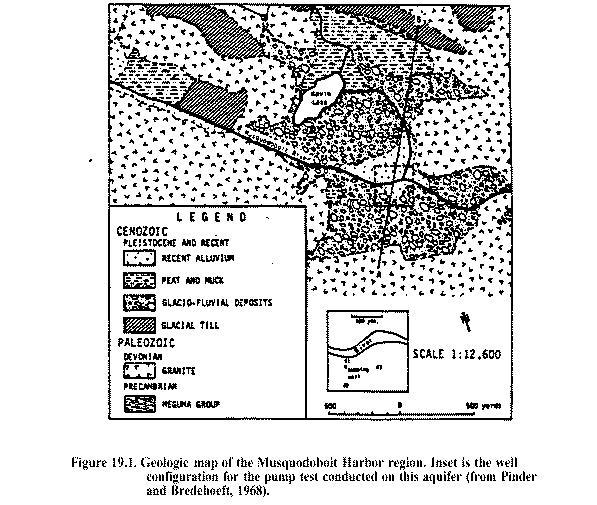
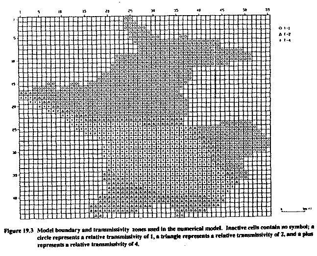
1 MODFLOW Lab 19: Application of a Groundwater Flow Model to a Water Supply Problem An Introduction to MODFLOW and SURFER The problem posed in this lab was reported in Chapter 19 of "A Manual of Instructional Problems for the U.S.G.S. MODFLOW Model," by P.F. Andersen, EPA/600/R-93/010, February The details about the problem were exerpted from the chapter along with additional comments provided by J.S. Gierke. Purpose Utilize groundwater modeling software to forecast the pumping drawdown in a regional aquifer for public drinking water supply Groundwater flow models are often used in water resource evaluations to assess the long-term productivity of local or regional aquifers. This exercise presents an example of an application to a local system and involves calibration to an aquifer test and prediction using best estimates of aquifer properties. Of historical interest, this problem is adapted from one of the first applications of a digital model to a water resource problem (cf. Pinder, G.F., and G.D. Bredehoeft, "Application of the digital computer for aquifer evaluation," Water Resources Research, 4, , 1968). The specific objective was to assess whether a glaciofluvial aquifer could provide an adequate water supply for a village in Nova Scotia. Objectives 1) Become familiar with MODFLOW and its various input packages 2) Gain experience in model calibration 3) Become aquainted with model data presentation (e.g., Surfer contours) Background The aquifer is located adjacent to the Musquodoboit River, ¼-mile northwest of the village of Musquodoboit Harbour, Nova Scotia. It is a glaciofluvial deposit consisting of coarse sand, gravel, cobbles, and boulders deposited in a U-shaped glacial valley (Figures 19.1 and 19.2). The aquifer, which is up to 62 feet thick, is extensively overlain by recent alluvial deposits of sand, silt and clay, which act as confining beds. For the purposes of our analysis, it is assumed that the aquifer is fully confined with several zones of varied transmissivity (Figure 19.3). A pump test was conducted to evaluate the aquifer transmissivity and storage coefficient, and to estimate recharge from the river. The test was run for 36 hours using a well discharging at cubic feet per second (432 gallons per minute, gpm) and three observation wells (Figure 19.4). The test was discontinued when the water level in the pumping well became stable. Initial estimates of aquifer parameters were calculated using the Theis curve and the early segment of the drawdown curves for the observation wells. The results were somewhat variable, ranging from 1.45 ft 2 /s to 0.3 ft 2 /s, due to influence of boundary conditions (the Musquidoboit River) on the pumping test. 1
2 Introduction to MODFLOW MODFLOW, developed by the U.S. Geological Survey, uses the finite difference method to obtain an approximate solution to the partial differential equations that describe the movement of groundwater of constant density through porous material. Hydrogeologic layers can be simulated as confined, unconfined, or a combination of confined and unconfined. External stresses such as wells, areal recharge, evapotranspiration, drains, and streams can also be simulated. Boundary conditions include specified head, specified flux, and head-dependent flux. Packages available in MODFLOW and their major function are: Table 1: Names and descriptions of MODFLOW input packages. Package Name (.extension) Problem Set up and Definition Basic (.bas) Block Centered Flow (.bcf) Boundary Condition Packages Well (.wel) Drain (.drn) Evapotranspiration (.et) River (.riv) General Head Boundary (.ghb) Recharge (.rch) Solution Technique Packages Strongly Implicit Procedure (.sip) Slice Successive Over Relaxation (.sor) Pre-conditioned Conjugate Gradient (.pcg) Output Control (.oc) Purpose Overall model setup and execution Sets up grid and material properties Specified constant flux condition Head-dependent flux condition limited to discharge Simulate areal withdrawal of water due to E/T. Head-dependent flux condition with a maximum Head-dependent flux condition, no maximum Specified areal flux input, e.g., infiltration Numerical solution technique Numerical solution technique Numerical solution technique Directs amount, type, and format of output Problem Scope For this first exercise, you are to gain experience in "using" MODFLOW and in manipulating input files manually. In future exercises, you will learn how to prepare input from scratch. So here, you will be using previously prepared input files and manipulating them just a little. This is just an introduction, you will by no means be an expert at the end of this. Obtaining and Organizing the Input Files To start, create a subdirectory: modflow and then off that one another modflow/lab19. All the files will be placed in the lab1 subdirectory. Remember, unix is case sensitive, so it is suggested that you work in lower case. Access the webpage: 2
3 Hold the SHIFT key down while clicking on each file with the left mouse button (Sun mouse) or right mouse button (PC mouse). When a pop-up menu appears asking where to save the file, insert the subdirectory path you created above (modflow/lab19) between your root diretory and the filename. You should have received the following data files (type ls -l): lab19.bas lab19.bcf lab19.wel lab19.riv lab19.sip lab19.oc Running MODFLOW The format of MODFLOW input files is give in Appendix A. You will use this appendix frequently. The version of MODFLOW that you will use here is called "surfmod" and this is run by typing the following: surfmod The program will ask for file names according to input and output unit numbers as defined below: Unit = 66: this is the standard MODFLOW output; the name is user specified. CAREFULL: you can overwrite other files if you do not provide a unique filename. Call this lab19.out Unit=1: lab19.bas; this is always the basic package, which defines the unit numbers for the other packages. The ones listed below are unique to this problem. Unit=11: lab19.bcf Unit=12: lab19.wel Unit=14: lab19.riv Unit=19: lab19.sip Unit=22: lab19.oc Unit=80: 1lay19.dat, this is a file prepared for input into Surfer contouring software. Ignore this file for the time being and overwrite it with each simulation during the calibration phase below. Run the model with these given data sets (a summary of the input is given in Table 19.1). Plot the drawdowns (using either an Excel or Applix spreadsheet) the observation wells and compare to the field data listed in Table Manipulate the value of the Transmissivity Multiplier and/or the Storativity (both can be found in lab1.bcf) until you are satisfied with the results. (Hint: It is pretty easy to edit lab1.bcf with the vi or pico editors, save it, and rerun surfmod. Use different names for the Unit=66 file for each run so that you can save them and zero in on the 3
4 best values of T & S.) Print out the graph with the "best" fit. You might as well know now that there is no combination of S and T that will yield an exact agreement. In fact, you will be able to match either the early time data (< 100 minutes) or the later time data (>100 minutes) but not both unless you use time-variable storage coefficient, which is beyond the scope of this lab. So fit the part you want realizing that you are calibrating to the pumptest data with the purpose of "forecasting" drawdowns for even longer times (see below). Once you have calibrated S and T, now run a simulation for 1000 days by altering the value of PERLEN in lab1.bas (the units are seconds) and NSTEPS (increase to 30, if not already set to 30). Using Surfer and 1lay19.dat, draw a drawdown contour for the aquifer region at 1000 days (the data for this is the last 2420 lines of data in the file 1lay19.dat). Examine the water budget calculations at the end of the best fit simulation (36-hrs) and the day simulation. Compare where the water is coming from between these two times. Introduction to Surfer The Surfer program is designed to generate contour plots of inputted data by three different methods (see Appendix B for a little more details): inverse distance, kriging, or minimum curvature. Inverse distance is an averaging method that weights data values such that the influence of a data point decreases with the distance from the grid value being generated. Kriging performs a moving average that defines trends in the data. High points in the same region of the map tend to be connected as ridges, or low points connected as troughs. Minimum curvature generates the smoothest surface of the three methods, however, data may not support the trends as shown. Surfer can also utilize MODFLOW output to generate drawdown contour maps. In this way, Surfer allows a visual representation of the effects of pumping on a hydrogeologic system. What to Hand in A spreadsheet plot of the model-simulated drawdowns compared to the observed drawdowns. Use good technical labelling practices. A contour plot for the 1000-day drawdown and use good technical labelling practices. A memo containing the following sections: (1) Background (simply reference the lab handout for the background information); (2) Objectives; (3) Approach (i.e., what did you use as a model, what parameters were calibrated and how); (4) Results and Discussion (Describe the calibration results and the contour plot, is the system at steady state at 1000 days, why or why not (use the water budget results)?, comment on weaknesses of and/or limitations to the calibration). 4
5 Table Input date for the water supply problem Grid: 44 rows, 55 columns, 1 layer Grid Spacing: Uniform 100 ft Initial Head: 0.0 ft Transmissivity: Non-uniform spatially, 3 zones Storage Coefficient: Uniform spatially Closure Criterion: Number of Time Steps: 10 Time Step Multiplier: Length of Simulation: 36 hours Production Well Location: Row 29, column 32 Pumping Rate: ft 3 /s (432 gpm) River Stage: 0.0 ft River Conductance: 0.02 ft 2 /s River Bottom Elevation: -10 ft Table Observed drawdown data from aquifer test Drawdown (ft) Time (min) Well 1 Well 2 Well
6 6
7 7
WELLHEAD PROTECTION DELINEATION REPORT FOR THE VILLAGE OF BEAR LAKE DECEMBER 2002
 WELLHEAD PROTECTION DELINEATION REPORT FOR THE VILLAGE OF BEAR LAKE DECEMBER 2002 Prepared by: Gosling Czubak Engineering Sciences, Inc. 1280 Business Park Drive Traverse City, Michigan 48686 Telephone:
Memorandum. Introduction. Carl Einberger Joe Morrice. Figures 1 through 7
 Memorandum TO: Michelle Halley, NWF DATE: October 9, 2007 FROM: Carl Einberger Joe Morrice PROJ. NO.: 9885.000 CC: Project File PROJ. NAME: National Wildlife Federation ATTACHMENTS: Tables 1 through 6
LAKE LABELLE DEWATERING MODEL. AUTHOR Gail Murray Doyle, P.G. September Murray Consultants, Inc 769 Skyview Dr Hayesville, NC
 LAKE LABELLE DEWATERING MODEL AUTHOR Gail Murray Doyle, P.G. September 2013 Murray Consultants, Inc 769 Skyview Dr Hayesville, NC 28904 828-389-2476 LAKE LABELLE DEWATERING MODEL INTRODUCTION Purpose The
Lab 6 - Pumping Test. Pumping Test. Laboratory 6 HWR 431/
 Pumping Test Laboratory 6 HWR 431/531 7-1 Introduction: Aquifer tests are performed to evaluate the capacity of an aquifer to meet municipal or industrial water requirements. Hydraulic characteristics
Disclaimer. Readme. Red text signifies a link.
 Disclaimer This is a scanned reproduction of the original document for distribution purposes via electronic format. Effort has been made to provide an accurate and correct document. The document is supplied
Aquifer Characterization and Drought Assessment Ocheyedan River Alluvial Aquifer
 Aquifer Characterization and Drought Assessment Ocheyedan River Alluvial Aquifer Iowa Geological Survey Water Resources Investigation Report 10 Aquifer Characterization and Drought Assessment Ocheyedan
Val Verde County / City of Del Rio Hydrogeological Study FINAL DRAFT REPORT
 Val Verde County / City of Del Rio Hydrogeological Study FINAL DRAFT REPORT May 2014 Hydrogeological Study For Val Verde County & City of Del Rio, Texas FINAL DRAFT REPORT MAY 2014 Prepared for Val Verde
DYNFLOW accepts various types of boundary conditions on the groundwater flow system including:
 Section 6 Groundwater Flow Model A groundwater flow model was developed to evaluate groundwater flow patterns in the site area and to provide a basis for contaminant transport modeling. 6.1 Model Code
Aquifer Science Staff, January 2007
 Guidelines for Hydrogeologic Reports and Aquifer Tests Conducted Within the Jurisdictional Boundaries of the Barton Springs / Edwards Aquifer Conservation District I. Introduction Aquifer Science Staff,
OUTLINE OF PRESENTATION
 GROUNDWATER?? OUTLINE OF PRESENTATION What is groundwater? Geologic investigation Definitions: aquifer and aquitard, unconfined and semi-confined Water level and interpretation of water level data Well
4.4 MODEL CODE DESCRIPTION 4.5 WATER SOURCES AND SINKS 4.6 MODEL DOMAIN AND BOUNDARIES. SLR South Africa
 Page 4-18 The developed model should therefore be seen as an initial site model which should be refined and recalibrated once more groundwater monitoring and other data become available. 4.4 MODEL CODE
RESPONSIBLE PLANNING FOR FUTURE GROUND WATER USE FROM THE GREAT FLATS AQUIFER : TWO CASE STUDIES: THE GEP ENERGY
 RESPONSIBLE PLANNING FOR FUTURE GROUND WATER USE FROM THE GREAT FLATS AQUIFER : TWO CASE STUDIES: THE GEP ENERGY Introduction PROJECT AND THE SI GREEN FUELS BOILER PROJECT Thomas M. Johnson Hydrogeologist,
Song Lake Water Budget
 Song Lake Water Budget Song Lake is located in northern Cortland County. It is a relatively small lake, with a surface area of about 115 acres, and an average depth of about 14 feet. Its maximum depth
CHAPTER 7 GROUNDWATER FLOW MODELING
 148 CHAPTER 7 GROUNDWATER FLOW MODELING 7.1 GENERAL In reality, it is not possible to see into the sub-surface and observe the geological structure and the groundwater flow processes. It is for this reason
Numerical Groundwater Flow Model Report. Caloosa Materials, LLC 3323 Gulf City Road Ruskin, Florida 33570
 Numerical Groundwater Flow Model Report Caloosa Materials, LLC 3323 Gulf City Road Ruskin, Florida 33570 GHD 2675 Winkler Ave Suite 180 Fort Myers, FL 33901 11138224 Report July 27, 2017 Table of Contents
SEES 503 SUSTAINABLE WATER RESOURCES GROUNDWATER. Instructor. Assist. Prof. Dr. Bertuğ Akıntuğ
 SEES 503 SUSTAINABLE WATER RESOURCES GROUNDWATER Instructor Assist. Prof. Dr. Bertuğ Akıntuğ Civil Engineering Program Middle East Technical University Northern Cyprus Campus SEES 503 Sustainable Water
Simulation of horizontal well performance using Visual MODFLOW
 Environ Earth Sci (2013) 68:1119 1126 DOI 10.1007/s12665-012-1813-x ORIGINAL ARTICLE Simulation of horizontal well performance using Visual MODFLOW Wan Mohd Zamri W. Ismail Ismail Yusoff Bahaa-eldin E.
Documentation of Groundwater Agent-based Model
 Documentation of Groundwater Agent-based Model Comments or suggestions to 1. Introduction In environmental resources management there is the recognition of need for combined socio-environmental
Groundwater Modeling
 Groundwater Modeling 8:00-8:30 a.m. Welcome and Introduction (Course Goals) 8:30-9:45 a.m. 1.1 Lecture Occurrence and Movement of Groundwater 9:45-10:00 a.m. Break A. Hydrologic Cycle B. Subsurface Distribution
The Hydrogeology Challenge: Water for the World TEACHER S GUIDE
 The Hydrogeology Challenge: Water for the World TEACHER S GUIDE Why is learning about groundwater important? 95% of the water used in the United States comes from groundwater. About half of the people
Potential effects evaluation of dewatering an underground mine on surface water and groundwater located in a rural area
 Potential effects evaluation of dewatering an underground mine on surface water and groundwater located in a rural area ITRODUCTIO Michel Mailloux* Eng. M.Sc, Vincent Boisvert, M.Sc, Denis Millette, Eng.,
Comparison between Neuman (1975) and Jacob (1946) application for analysing pumping test data of unconfined aquifer
 and Jacob (1946) application for analysing pumping test data of unconfined aquifer") Comparison between Neuman (1975) and Jacob (1946) application for analysing pumping test data of unconfined aquifer Dana Mawlood 1*, Jwan Mustafa 2 1 Civil Engineering Department, College of Engineering,
Comparison between Neuman (1975) and Jacob (1946) application for analysing pumping test data of unconfined aquifer Dana Mawlood 1*, Jwan Mustafa 2 1 Civil Engineering Department, College of Engineering,
Supplemental Guide II-Delineations
 Supplemental Guide II-Delineations Contents Source Water Protection Area Delineation... 1 Delineation Criteria for Systems Using Groundwater Sources... 2 Time of Travel... 4 Flow Boundaries... 4 Delineation
GROUNDWATER AVAILABILITY MODELING OF THE WEST NISHNABOTNA AQUIFER IN IOWA. Iowa Geological Survey Water Resource Investigation Report 3
 GROUNDWATER AVAILABILITY MODELING OF THE WEST NISHNABOTNA AQUIFER IN IOWA Iowa Geological Survey Water Resource Investigation Report 3 Iowa Department of Natural Resources Patricia L. Boddy, Interim Director
Investigation of a Floodplain Pond to Improve Alluvial Aquifer Sustainability: A Quantity and Quality Report
 Investigation of a Floodplain Pond to Improve Alluvial Aquifer Sustainability: A Quantity and Quality Report Water Resources Investigation Report 16 i P a g e Investigation of a Floodplain Pond to Improve
Questions: What is calibration? Why do we have to calibrate a groundwater model? How would you calibrate your groundwater model?
 Questions: What is calibration? Why do we have to calibrate a groundwater model? How would you calibrate your groundwater model? 13-11-2009 1 Uncertainties in groundwater models Conceptual model uncertainty
4. Groundwater Resources
 4. Groundwater Resources 4-1 Majority (97 %) of unfrozen fresh water on earth exists as groundwater. In comparison to surface water, - groundwater is available all year around - groundwater is mostly invisible
Using GIS, MODFLOW and MODPATH for groundwater management of an alluvial aquifer of the River Sieg, Germany
 HydroGIS 96: Application of Geographic Information Systems in Hydrology and Water Resources Management (Proceedings of the Vienna Conference, April 1996). IAHS Publ. no. 235, 1996. 551 Using GIS, MODFLOW
8 Time-drawdown analyses
 8 Time-drawdown analyses this, the geology of the test site must be properly known. Well logs may indicate which type of aquifer you are dealing with, i.e. whether it can be regarded as confined, leaky,
ENGINEERING HYDROLOGY
 ENGINEERING HYDROLOGY Prof. Rajesh Bhagat Asst. Professor Civil Engineering Department Yeshwantrao Chavan College Of Engineering Nagpur B. E. (Civil Engg.) M. Tech. (Enviro. Engg.) GCOE, Amravati VNIT,
Name: Problem 1. (30 points; 5 each)
") 2700 2500 1900 2100 1500 2300 1800 1700 Hydrogeology - HWR/GEOS 431/531 Final exam Dr. Marek Zreda 16 December 1998 11:00-1:00 Open books and notes There are 5 problems on 7 pages. Read entire test before
2700 2500 1900 2100 1500 2300 1800 1700 Hydrogeology - HWR/GEOS 431/531 Final exam Dr. Marek Zreda 16 December 1998 11:00-1:00 Open books and notes There are 5 problems on 7 pages. Read entire test before
Predicting Groundwater Sustainability: What Tools, Models and Data are Available?
 Predicting Groundwater Sustainability: What Tools, Models and Data are Available? Ray Wuolo Barr Engineering Company Assessing Sustainability is All About: Predicting (or describing) how potentiometric
Development and Application of Surface-Water Groundwater Flow Model of the Tuul River Basin near Ulaanbaatar, Mongolia
 Development and Application of Surface-Water Groundwater Flow Model of the Tuul River Basin near Ulaanbaatar, Mongolia November 2016 Approved for Public Release. Distribution Unlimited. REPORT DOCUMENTATION
Well Head Delineation Zone Analysis for Nantucket Island, Massachusetts. Assigned: April 2 nd, 2012 Presentation and Reports Due: April 16 th, 2012
 Well Head Delineation Zone Analysis for Nantucket Island, Massachusetts Assigned: April 2 nd, 2012 Presentation and Reports Due: April 16 th, 2012 Semester Project I NM Tech, H547 1 INTRODUCTION The Wannacomet
CHRISTCHURCH CITY GROUNDWATER MODEL
 CHRISTCHURCH CITY GROUNDWATER MODEL Mike Thorley 1, Peter Callander 1, Howard Williams 1, Hilary Lough 1, Mike Kininmonth 2, Bruce Henderson 2 1 Pattle Delamore Partners Ltd Level 2, Radio New Zealand
MEMORANDUM. RAI Responses Related to East Lake Road Wellfield Drawdown Analysis, WUP No SDI Project No. PCF-180.
 SDI Environmental Services, Inc. 13911 N. Dale Mabry Hwy. Suite 201, Tampa, FL 33618; (813) 961-1935 MEMORANDUM TO: FROM: SUBJECT: Dave Slonena, P.G., Pinellas County Cathleen Beaudoin Jonas RAI Responses
Part 1: Steady Radial Flow Questions
 Islamic University of Gaza Water Resources Management EENV 4359 First Semester (2014-2015) Instructors: Dr. Yunes Mogheir Eng. Wael Salem Eng. Israa Abushaban Question 1 (text book) Part 1: Steady Radial
Investigative Study of Conjunctive Use Opportunities in the Stony Creek Fan Aquifer
 Investigative Study of Conjunctive Use Opportunities in the Stony Creek Fan Aquifer Abstract: A USGS MODFLOW model is developed to aid in understanding the interaction between Stony Creek and the underlying,
OPTIMIZED REMEDIAL GROUNDWATER EXTRACTION USING LINEAR PROGRAMMING
 John J. Q U ~ M EAD 9 Argonne, IL 6439 Tel.: 78-252-5357, Fax: 78-252-3611 OPTIMIZED REMEDIAL GROUNDWATER EXTRACTION USING LINEAR PROGRAMMING ABSTRACT Groundwater extraction systems are typically installed
6.0 USGS MODEL. 6.1 Background
 6.0 USGS MODEL 6.1 Background A groundwater flow model is a simplification of a real groundwater flow system. Real groundwater flow systems are complex, and they are often simplified with a model for the
FDEP Site Priority Scoring Guidance
 FDEP Site Priority Scoring Guidance Criteria: Requirements: Fire/Explosion Hazard 1. Free product or volatilized petroleum products at or above 20% of the Lower Explosive Limit (LEL) in existing utility
ALABAMA GROUNDWATER SUSTAINABILITY: A STRONG SCIENTIFIC FOUNDATION FOR WATER RESOURCE MANAGEMENT AND POLICY TO SECURE ALABAMA S WATER FUTURE
 ALABAMA GROUNDWATER SUSTAINABILITY: A STRONG SCIENTIFIC FOUNDATION FOR WATER RESOURCE MANAGEMENT AND POLICY TO SECURE ALABAMA S WATER FUTURE Marlon Cook Geological Survey of Alabama Groundwater Assessment
Using MODFLOW/MODPATH combined with GIS analysis for groundwater modelling in the alluvial aquifer of the River Sieg, Germany
 Models for Assessing and Monitoring Groundwater Quality (Proceedings of a Boulder Symposium July 1995). IAHSPubl.no. 227, 1995. 117 Using MODFLOW/MODPATH combined with GIS analysis for groundwater modelling
Groundwater modelling study for sustainable water management in Town of High River. Han Sang-Yoon WaterTech, April 12, 2013
 Groundwater modelling study for sustainable water management in Town of High River Han Sang-Yoon WaterTech, April 12, 2013 Acknowledgements Town of High River: Reiley McKerracher Jasen Craigie Project
SOURCES OF WATER SUPPLY GROUND WATER HYDRAULICS
 SOURCES OF WATER SUPPLY GROUND WATER HYDRAULICS, Zerihun Alemayehu GROUNDWATER Groundwater takes 0.6% of the total water in the hydrosphere 0.31% of the total water in the hydrosphere has depth less than
Task 4.2 Technical Memorandum on Pumping Impacts on Squaw Creek
 Task 4.2 Technical Memorandum on Pumping Impacts on Squaw Creek Aquifer Test 1 Aquifer Test 2 Prepared for: Squaw Valley Public Service District April 2013 Prepared by: This page left intentionally blank
Lecture 20: Groundwater Introduction
 Lecture 20: Groundwater Introduction Key Questions for Groundwater 1. What is an aquifer? 2. What is an unconfined aquifer? 3. What is groundwater recharge? 4. What is porosity? What determines the magnitude
J. Wetstein and V. Hasfurther Conference Proceedings WWRC
 RESPONSE OF A SURFACE AQUIFER TO FLOOD IRRIGATION J. Wetstein and V. Hasfurther 1989 Conference Proceedings WWRC- 8 9-32 In Proceedings of the Specialty Conference Sponsored by the Irrigation and Drainage
Hydrogeology and Simulation of Ground- Water Flow in a Glacial-Aquifer System at Cortland County, New York
 In Cooperation with Cortland County Soil and Water Conservation District Hydrogeology and Simulation of Ground- Water Flow in a Glacial-Aquifer System at Cortland County, New York The City of Cortland
Case Study A Comparison of Well Efficiency and Aquifer Test Results Louvered Screen vs. Continuous Wire-Wrapped Screen Big Pine, California
 Case Study A Comparison of Well Efficiency and Aquifer Test Results Louvered Screen vs. Continuous Wire-Wrapped Screen Big Pine, California Executive Summary Aquifer test results demonstrated that the
T E C H N I C A L M E M O R A N D U M
 INTERA Incorporated 9600 Great Hills Trail, Suite 300W Austin, Texas, USA 78759 512.425.2000 T E C H N I C A L M E M O R A N D U M To: From: Barton Springs/Edwards Aquifer Conservation District Wade Oliver,
University of Arizona Department of Hydrology and Water Resources Dr. Marek Zreda. HWR431/531 - Hydrogeology Problem set #1 9 September 1998
 University of Arizona Department of Hydrology and Water Resources Dr. Marek Zreda HWR431/531 - Hydrogeology Problem set #1 9 September 1998 Problem 1. Read: Chapter 1 in Freeze & Cherry, 1979. McGuiness
APPENDIX 5: SAMPLE MODEL RESULTS
 APPENDIX 5: SAMPLE MODEL RESULTS A. Evaluation of Groundwater Sustainability in the Ramsey Area B. Evaluation of Groundwater Sustainability in the Woodbury Area C. Evaluation of Future Drawdown Conditions
*** IN THE PUMPING WELL
 Specific Capacity = discharge rate/max drawdown after pumping at a constant, known rate for a time until apparent equilibrium is reached (i.e., minimal change in drawdown with time) Theis et al, 1963 -
Livingston County Department of Public Health Environmental Health Division. Hydrogeologic Investigation Requirements for Land Division Developments
 Livingston County Department of Public Health Environmental Health Division Hydrogeologic Investigation Requirements for Land Division Developments Reviewed March 1, 2013 Table of Contents Scope/Authority..1
CHAPTER 2. Objectives of Groundwater Modelling
 CHAPTER 2 Objectives of Groundwater Modelling In the last two decades mathematical modelling techniques have increasingly proved their value in furthering the understanding of groundwater systems and,
Evaluating Impoundment Closure Scenarios using Fate and Transport Modeling
 2017 World of Coal Ash (WOCA) Conference in Lexington, KY - May 9-11, 2017 http://www.flyash.info/ Evaluating Impoundment Closure Scenarios using Fate and Transport Modeling Jacob J. Walczak 1, Meng Wang
GRACE: Tracking Water from Space. Groundwater Storage Changes in California s Central Valley Data Analysis Protocol for Excel: PC
 Groundwater Storage Changes in California s Central Valley Data Analysis Protocol for Excel: PC 2007-10 Before GRACE it was very difficult to estimate how the total volumes of groundwater are changing.
Drought Assessment and Local Scale Modeling of the Sioux Center Alluvial Wellfield. Water Resources Investigation Report 13
 Drought Assessment and Local Scale Modeling of the Sioux Center Alluvial Wellfield Water Resources Investigation Report 13 Cover Photograph: Looking north toward Sioux Center Well 8 Drought Assessment
MODELLING THE GROUNDWATER FLOW FOR ESTIMATING THE PUMPING COST OF IRRIGATION IN THE AQUIFER OF N. MOUDANIA, GREECE
 Proceedings of the 13 th International Conference on Environmental Science and Technology Athens, Greece, 5-7 September 2013 MODELLING THE GROUNDWATER FLOW FOR ESTIMATING THE PUMPING COST OF IRRIGATION
Hydrogeology Laboratory Semester Project: Hydrogeologic Assessment for CenTex Water Supply, Inc.
 Hydrogeology Laboratory Semester Project: Hydrogeologic Assessment for CenTex Water Supply, Inc. Matthew M. Uliana, Ph.D. Department of Biology Geology Program and Aquatic Resources Texas State University
Abstract. Introduction
 Invited Paper The modelling of saline intrusion during the construction of submerged tunnels T. Roberts', J. White, Z. Mohammed' "WJ Engineering Resources Ltd. Civil Engineering, Queen Mary and Westfield
University of Arizona Department of Hydrology and Water Resources Dr. Marek Zreda
 University of Arizona Department of Hydrology and Water Resources Dr. Marek Zreda HWR431/531 - Hydrogeology Final exam - 12 May 1997 Open books and notes The test contains 8 problems on 7 pages. Read the
Groundwater Level and Movement
 Groundwater Level and Movement Infiltration and Recharge Infiltration Entry of rain water into the ground. Recharge Addition of infiltrated water to the aquifer. Two types of Recharge- 1. Natural 2. Artificial
NOTE ON WELL SITING AT CORNER OF CASTLE VALLEY DRIVE AND SHAFER LANE FOR TOWN OF CASTLE VALLEY, GRAND COUNTY, UTAH
 NOTE ON WELL SITING AT CORNER OF CASTLE VALLEY DRIVE AND SHAFER LANE FOR TOWN OF CASTLE VALLEY, GRAND COUNTY, UTAH Authors: Dr. Kenneth E. Kolm, Hydrologic Systems Analysis, LLC., Golden, Colorado and
Modeling with MLU. applying the multilayer approach to aquifer test analysis. Tutorial. Kick Hemker & Jeff Randall. Amsterdam Seattle 1
 Modeling with MLU applying the multilayer approach to aquifer test analysis Tutorial Kick Hemker & Jeff Randall Amsterdam Seattle 1 CONTENTS 1. Introduction.......................................................
Modeling the Managed Aquifer Recharge for Groundwater Salinity Management in the Sokh River Basin
 Modeling the Managed Aquifer Recharge for Groundwater Salinity Management in the Sokh River Basin A. Karimov, 1 I. Gracheva, 2 F. Miryusupov 2 1 International Water Management Institute (IWMI) Central
Dynamic groundwater-river interaction model for planning water allocation in a narrow valley aquifer system of the Upper Motueka catchment
 Dynamic groundwater-river interaction model for planning water allocation in a narrow valley aquifer system of the Upper Motueka catchment Timothy Hong t.hong@gns.cri.nz Gilles Minni g.minni@gns.cri.nz
DRAFT. APPENDIX F Groundwater Flow Model Proposed El Segundo Desalination Facility
 APPENDIX F Proposed El Segundo Desalination Facility Proposed El Segundo Desalination Facility 1. GROUNDWATER FLOW MODEL Based on review of offshore and onshore hydrogeologic data including the Summer
Investigation of sustainable development potential for Ulubey Aquifer System, Turkey
 doi:10.5194/piahs-364-513-2014 Evolving Water Resources Systems: Understanding, Predicting and Managing Water Society Interactions Proceedings of ICWRS2014, Bologna, Italy, June 2014 (IAHS Publ. 364, 2014).
The Corning Primary Aquifer -One of 18. NYSDEC Primary Aquifers in New York
 The Corning Primary Aquifer -One of 18 NYSDEC Primary Aquifers in New York NYSDEC Primary and Principal Aquifers PRIMARY AQUIFERS (18) Highly productive aquifers presently being utilized by major municipal
Irrigation modeling in Prairie Ronde Township, Kalamazoo County. SW Michigan Water Resources Council meeting May 15, 2012
 Irrigation modeling in Prairie Ronde Township, Kalamazoo County SW Michigan Water Resources Council meeting May 15, 2012 Development of a Groundwater Flow Model INFLOWS Areal recharge from precipitation
Standard Guide for Conducting a Sensitivity Analysis for a Ground-Water Flow Model Application 1
 Designation: D 5611 94 (Reapproved 2002) Standard Guide for Conducting a Sensitivity Analysis for a Ground-Water Flow Model Application 1 This standard is issued under the fixed designation D 5611; the
FAX
 21335 Signal Hill Plaza Suite 100 Sterling, Virginia 20164 www.geotransinc.com 703-444-7000 FAX 703-444-1685 Mr. William Kutash Florida Department of Environmental Protection Waste Management Division
Grounding Water: An Exploration of the Unseen World Beneath Our Feet
 1 Grounding Water: An Exploration of the Unseen World Beneath Our Feet Kerry Schwartz, Director, Arizona Project WET Protect Your Groundwater Day: Tuesday, September 9, 2014 What I Hope to Convey Groundwater
AQUIFER STORAGE AND RECOVERY EVALUATION REPORT
 AQUIFER STORAGE AND RECOVERY EVALUATION REPORT Prepared for: CLALLAM COUNTY 228 East 4 th Street, Port Angeles, WA 98362 Prepared by: 12100 NE 195 th Street, Suite 200, Bothell, WA 99011 July 2003 TABLE
Quantifying Effects of Humans and Climate on Groundwater Resources Through Modeling of Volcanic-Rock Aquifers of Hawaii
 Quantifying Effects of Humans and Climate on Groundwater Resources Through Modeling of Volcanic-Rock Aquifers of Hawaii University of Hawaii Volcanic rock Freshwater Saltwater Kolja Rotzoll, Scot K. Izuka,
Groundwater Flow in a Desert Basin Complexity and Controversy
 Groundwater Flow in a Desert Basin Complexity and Controversy Charles Andrews 1 and Chris Neville 2 1 S.S. Papadopulos & Associates, Inc., Bethesda, Maryland 2 S.S. Papadopulos & Associates, Inc., Waterloo,
GW Engineering EXAM I FALL 2010
 PROBLEM #1-25 points USE UNITS of METERS SECONDS and GRAMS Prepare a water budget for the year 2009 for the unconfined sedimentary aquifer that constitutes the basin illustrated below. The basin is surrounded
NON BIODEGRADABLE CONTAMINANTS TRANSPORT MODELING WITH VARYING TRANSMISSIVITY FOR AQUIFER AT WEST CAMPUS HBTI KANPUR
 NON BIODEGRADABLE CONTAMINANTS TRANSPORT MODELING WITH VARYING TRANSMISSIVITY FOR AQUIFER AT WEST CAMPUS HBTI KANPUR Ravi Kumar Singh 1, Dr. Deepesh Singh 2 M.Tech. Student, Dept. of Civil Engineering,
PONDS 3.2 TECHNICAL MEMO
 PONDS 3.2 TECHNICAL MEMO Date: December 7, 2007 Re: Using PONDS for Dewatering Analysis The following technical memo outlines the use of the PONDS 3.2 Refined Method software to perform a dewatering analysis
Simulation of Groundwater Conditions in the Upper San Pedro Basin for the. Evaluation of Alternative Futures. Tomas Charles Goode. Thomas Maddock III
 Simulation of Groundwater Conditions in the Upper San Pedro Basin for the Evaluation of Alternative Futures by Tomas Charles Goode and Thomas Maddock III Alternative Futures 1 Alternative Futures Study
A three dimensional modeling approach to groundwater management in Paharpur Canal Command Area, Dera Ismail Khan, Pakistan
 European Water 57: 417-422, 2017. 2017 E.W. Publications A three dimensional modeling approach to groundwater management in Paharpur Canal Command Area, Dera Ismail Khan, Pakistan A. Khan 1*, A. Qadir
GROUND WATER/SURFACE WATER INTERACTIONS AWRA SUMMER SPECIALTY CONFERENCE Judith Schenk'
 July 1-3 GROUND WATER/SURFACE WATER INTERACTIONS AWRA SUMMER SPECIALTY CONFERENCE 2002 326x6 pjf= INTEGRATION OF DATA USING GIS AND STATEPP TO ESTIMATE GROUNDWATER MODEL INPUT PARAMETERS Judith Schenk'
Numerical Modeling of Groundwater Flow in the Navajo Sandstone Aquifer at the Tuba City, Arizona, Disposal Site 15167
 Numerical Modeling of Groundwater Flow in the Navajo Sandstone Aquifer at the Tuba City, Arizona, Disposal Site 15167 ABSTRACT Richard Bush*, Timothy Bartlett** *US DOE, Office of Legacy Management **Stoller
Response to Reviewers #2 Comments (Major review): Manuscript NHESS
: Manuscript NHESS") Response to Reviewers #2 Comments (Major review): Manuscript NHESS-2013-167 The authors thank the reviewer for their helpful comments and suggestions. In the document below we have listed the reviewer
Response to Reviewers #2 Comments (Major review): Manuscript NHESS-2013-167 The authors thank the reviewer for their helpful comments and suggestions. In the document below we have listed the reviewer
FLOW IN POROUS MEDIA LUÍS RIBEIRO INSTITUTO SUPERIOR TECNICO UNIVERSITY OF LISBON
 FLOW IN POROUS MEDIA LUÍS RIBEIRO INSTITUTO SUPERIOR TECNICO UNIVERSITY OF LISBON Where does groundwater flow? How water flows? Groundwater moves from areas of high hydraulic head to areas of low hydraulic
Estimating Streambed and Aquifer Parameters from a Stream/Aquifer Analysis Test
 Hydrology Days 2003, 68-79 Estimating Streambed and Aquifer Parameters from a Stream/Aquifer Analysis Test Garey Fox 1 Ph.D. Candidate, Water Resources, Hydrologic, and Environmental Sciences Division,
Numerical modelling of ground water flow using MODFLOW,
 ISSN 2319 7730 EISSN 2319 7749 RESEARCH Indian Journal of Science, Volume 2, Number 4, February 2013 RESEARCH Indian Journal of Science Numerical modelling of ground water flow using MODFLOW Kumar CP Scientist
Scale Effects in Large Scale Watershed Modeling
 Scale Effects in Large Scale Watershed Modeling Mustafa M. Aral and Orhan Gunduz Multimedia Environmental Simulations Laboratory School of Civil and Environmental Engineering Georgia Institute of Technology
Predicting seasonal variation and mounding of groundwater in shallow groundwater systems
 Predicting seasonal variation and mounding of groundwater in shallow groundwater systems Mr Kelly Norris Senior Engineer, Essential Environmental, Perth, Australia E-mail: kelly@essentialenvironmental.com.au
Storage and Flow of Groundwater
 Storage and Flow of Groundwater Aquifer AQUIFER (in Greek)= AQUA (water) + FERRE (to bear) Aquifer- a saturated geological formation which will yield sufficient quantity of water to wells and springs Underground
DEVELOPMENT OF AQUIFER TESTING PLANS. Brent Bauman, P.G. / Erin Lynam, Aquatic Biologist
 DEVELOPMENT OF AQUIFER TESTING PLANS Brent Bauman, P.G. / Erin Lynam, Aquatic Biologist DEVELOPMENT OF AQUIFER TESTING PLANS Goals of Aquifer Testing What questions are we trying to answer Staff review
Regional Groundwater Flow Modeling of Yarkant Basin in West China
 Conference on Environmental Pollution and Public Health Regional Groundwater Flow Modeling of Yarkant Basin in West China Sun Jinyu Zhang Qiang Xu Mo College of Environment and Civil Engineering, Chengdu
Assessment of the Groundwater Quantity Resulting from Artificial Recharge by Ponds at Ban Nong Na, Phitsanulok Province, Thailand
 Research article erd Assessment of the Groundwater Quantity Resulting from Artificial Recharge by Ponds at Ban Nong Na, Phitsanulok Province, Thailand SIRIRAT UPPASIT* Faculty of Technology, Khon Kaen
Optimization modeling for groundwater and conjunctive use water policy development
 Utah State University DigitalCommons@USU Civil and Environmental Engineering Faculty Publications Civil and Environmental Engineering 2004 Optimization modeling for groundwater and conjunctive use water
7.0 GROUNDWATER AND STABILIZER TRANSPORT MODELING
 7.0 GROUNDWATER AND STABILIZER TRANSPORT MODELING 7.1 Introduction The concept of passive site remediation is the slow injection of stabilizing materials at the up gradient edge of a site and delivery
Environmental Data Management and Modeling, Niagara Falls Storage Site Lewiston, New York
 Environmental Data Management and Modeling, Niagara Falls Storage Site Lewiston, New York Eric Evans and Don DeMarco HydroGeoLogic, Inc. May 7, 2008 Mr. Eric Evans, M.Sc., P.G. is a Senior Hydrogeologist
 5. MODEL DESCRIPTION Several models were used in combination to estimate the impacts of the proposed 100,000 acre-ft dryyear yield program. MODFLOW and MODPATH were used to estimate the groundwater and
Balancing Total Estimated Recoverable Storage and. Wade A. Oliver, P.G. Texas Alliance of Groundwater Districts Groundwater Summit August 27, 2015
 Balancing Total Estimated Recoverable Storage and Sustainability Wade A. Oliver, P.G. Texas Alliance of Groundwater Districts Groundwater Summit August 27, 2015 The 9 Factors Districts Shall Consider When