Integrated Water Resources Master Plan
|
|
|
- Janel Lloyd
- 6 years ago
- Views:
Transcription

1 Integrated Water Resources Master Plan El Dorado Irrigation District March 31, 2013 Robert H. Ellis NO EXP. 12/31/13 Holly Kennedy NO EXP. 12/31/13 Prepared under the responsible charge of Robert H. Ellis Holly Kennedy N. California Blvd., Suite 475, Walnut Creek, CA 94596
2
3 Executive Summary... 1 ES-1 Background... 1 ES-1.1 Project Vision and Objectives... 1 ES-1.2 Key Issues... 4 ES-1.3 Stakeholder Involvement... 4 ES-2 Existing and Projected Water Demands... 4 ES-3 Existing Water Supplies and Systems... 5 ES-4 Alternatives Development and Evaluation... 6 ES-4.1 Description and Screening of Alternative Concepts... 6 ES-4.2 Formulation of Alternatives... 7 ES-4.3 Evaluation of Alternatives... 7 ES-5 Recommended Water Resources Plan ES-5.1 Phasing of Recommended Facilities ES-6 Financing ES-6 Benefits of Recommended Plan ES-7 Recommended Implementation Schedule and Next Steps Introduction Background Service Area Description Local Climate Population, Employment, and Housing Previous Studies and References Project Vision and Objectives Key Issues Water Supply Reliability Water Supply and Infrastructure Constraints Competing Water Resource Needs Future Role of Recycled Water Water Resource Planning and Operations Tools Scope of Work Stakeholder Involvement... 35
4 1.7 Report Organization Abbreviations Existing Water Supplies and Systems Water Service Regions Existing Water Supplies Appropriative Water Rights Sly Park Dam and Jenkinson Lake Folsom Reservoir South Fork American River and Project 184 Reservoirs Project 184 and Permit North Fork Cosumnes River, Clear Creek, and Squaw Hollow Creek Middle Fork Cosumnes River Recycled Water Potable Water System Facilities Treatment Facilities Transmission System Storage Facilities Regulatory Requirements Existing Capital Improvement Plan Integration with Wastewater and Recycled Water Systems Basis of Planning Study Area Planning Period Land Use Ongoing Studies District Policies Design Criteria Climate Change Basis of Cost Estimates Integrated Water Resources Planning Approach... 85
5 4.0 Existing and Projected Water Demands Methodology Water Use Factors Land Use Based Demand Calculation Demand Projections System Losses Conservation Savings Projected Buildout Demands Growth Rate Analysis Interim Growth Projections Water Supply and Demand Comparison Annual Water Supply and Demand Water Production Requirements Identification and Screening of Water Resources Concepts Demand Management Water Conservation Water Loss Reduction Study Water Loss Control Program Pressure Management Leak Detection Program Water Resources Concepts and Screening Process Concept Screening Screening Criteria Description of Water Resource Concepts Concept 1. Water Supplies Concept 2. Surface Water Storage Concept 3. Recycled Water Concept 4. Other Options Preliminary Screening Results Formulation of Water Resources Alternatives Common Elements Demand Side Management
6 6.1.2 Recycled Water Water Supply Transmission System Model New Water Treatment Plant Site Selection El Dorado Hills Water Treatment Plant New Water Treatment Plant in Western Region Phasing Alternative IA Gravity Supply Water Supply Water Production Facilities Transmission System Facilities Summary Alternative IB Gravity Supply with Medium Alder Reservoir Water Supply Water Production Facilities Transmission System Facilities Summary Alternative IC Gravity Supply with Small Alder Reservoir Water Supply Water Production Facilities Transmission System Facilities Summary Alternative II Pumped Supply Water Supply Water Production Facilities Transmission System Facilities Summary Alternative IIIA Pumped / Gravity Supply Water Supply Water Production Facilities Transmission System Facilities Summary Alternative IIIB Pumped / Gravity Supply with White Rock Deferred
7 Water Supply Water Production Facilities Transmission System Facilities Summary Alternative IIIC Pumped / Gravity Supply with Medium Alder Reservoir Water Supply Water Production Facilities Transmission System Facilities Summary Evaluation of Water Resources Alternatives Alternative Evaluation Criteria Criterion 1: Minimizes Cost Criterion 2: Maximizes Availability of Water Supplies Criterion 3: Increases Dry Year Water Supply Reliability Criterion 4: Opportunities for Other Benefits Criterion 5: Provides Flexibility for Implementation Criterion 6: Minimizes Environmental Impacts Criterion 7: Minimizes Implementation Risk Economic Evaluation Non-Economic Evaluation Maximizes Availability of Water Supplies Increases Dry Year Water Supply Reliability Opportunities for Other Benefits Provides Flexibility for Implementation Minimizes Environmental Impacts Minimizes Implementation Risk Conclusions Recommended Water Resources Plan Water Supply White Rock Diversion Alder Reservoir Ongoing Coordination with Regional Programs
8 8.2 Water Treatment Reservoir 1 Water Treatment Plant Reservoir A Water Treatment Plant El Dorado Hills Water Treatment Plant New Water Treatment Plant Water Transmission System Transmission Pipelines Treated Water Storage Reservoirs Operational Considerations Recycled Water System Water Conservation Infrastructure Renewal and Replacement Framework for Condition Assessment and Asset Management Fixed Asset Inventory Asset Renewal Methodologies Asset Renewal Decision Processes Condition Assessments Coordination with Hydroelectric Development Estimated Costs Benefits of Recommended Plan Water Resources Plan Implementation Integrated Water Resources Approach Phasing of Recommended Facilities Feasibility Studies and Engineering Environmental Compliance and Permitting Coordination with Ongoing Projects and Programs Financing Stakeholder Outreach Use of IWRMP Processes and Tools Implementation Schedule
9 Figure ES-1. Study Area... 3 Figure ES-2. Projected Water Demands... 5 Figure ES-3. Alternative Development and Evaluation Process... 6 Figure ES-4. Future Water Supply Concepts... 9 Figure ES-5. Integration and Development of Alternatives IA and IC Figure ES-6. Recommended Water Resources Plan Figure ES-7. Forecasted Demand and Water Production Capacity Figure ES-8. Implementation Schedule Figure 1-1. Project Study Area and Water Supply Areas Figure 2-1. Water Supply Regions and Service Zones Figure 2-2. Existing Water Supply Sources Figure 2-3. Existing Treatment, Storage, Transmission System Figure 2-4. Water Treatment Plant Process Flow Diagram Reservoir Figure 2-5. Water Treatment Plant Process Flow Diagram - Reservoir A Figure 2-6. Water Treatment Plant Process Flow Diagram - El Dorado Hills Figure 2-7. Water Transmission System Hydraulic Profile Figure 3-1. General Plan Land Use Designations Figure 3-2. Integrated Water Resources Planning Approach Figure 4-1. Future Land Use Figure 4-2. Comparison of Existing Water Supply and Projected Annual Demand Figure 4-3. Comparison of Existing Water Production Capacity and Projected MDD Figure 5-1. Alternative Development and Evaluation Process Figure 5-2. Future Water Supply Concepts Figure 6-1. New Water Treatment Plant Site Options Figure 6-2. Alternative IA Gravity Supply Figure 6-3. Alternative IB Gravity Supply with Medium Alder Reservoir Figure 6-4. Alternative IC Gravity Supply with Small Alder Reservoir Figure 6-5. Alternative II Pumped Supply Figure 6-6. Alternative IIIA Pumped / Gravity Supply Figure 6-7. Alternative IIIB Pumped / Gravity Supply with White Rock Deferred Figure 6-8. Alternative IIIC Pumped / Gravity Supply with Alder Reservoir Figure 7-1. Summary of Present Value Costs by Phase Figure 8-1. Integration and Development of Alternatives IA and IC Figure 8-2. Recommended Water Resources Plan Figure 8-3. White Rock Diversion Facilities
10 Figure 8-4. Alder Reservoir Facilities Figure 8-5. New Transmission Main, Eastern Segment Figure 8-6. New Transmission Main, Western Segment Figure 8-7. Updated Water Supply Regions Figure 8-8. Buildout Recycled Water Supply and Demand Figure 8-9. Maintenance, Repair, Rehabilitation and Replacement Decision Process 227 Figure 9-1. Forecasted Demand and Water Production Capacity Figure 9-2. Implementation Schedule
11 Table ES-1. Summary of Required Facilities for Recommended Plan Table ES-2. Estimated Capital Costs by Phase for the Recommended Plan Table ES-3. Benefits of the Recommended Plan Table 2-1. Existing Water Supply Sources Table 2-2. Water Treatment Plant Production and Peaking Factor Table 2-3.Transmission System Pipelines Table 2-4. Existing Storage Facilities Table 2-5. Storage Requirement Criteria Table 2-6. Summary of Drinking Water Regulation Implications Table 3-1. Basis of Cost Estimates Table 4-1. Single Family Residential Water Use Factors Table 4-2. Summary of Future Water Demands Table 4-3. Summary of Water Demands by Region Table 4-4. Historical Growth Rates by Region, Table 4-5. Projected Growth Rates by Region Table 4-6. Water Demand Growth Forecasts Table 4-7. Comparison of Existing Water Production Capacity and Projected MDD Table 5-1. Future Water Supply Concepts Table 6-1. Normal Year Water Supply for Each Alternative Table 6-2. New Water Treatment Plant Site Evaluation Table 6-3. Alternative IA - Flow Balance Table 6-4. Alternative IA - Summary of Required Facilities Table 6-5. Alternative IB - Flow Balance Table 6-6. Alternative IB - Summary of Required Facilities Table 6-7. Alternative IC - Flow Balance Table 6-8. Alternative IC - Summary of Required Facilities Table 6-9. Alternative II - Flow Balance Table Alternative II - Summary of Required Facilities Table Alternative IIIA - Flow Balance Table Alternative IIIA - Summary of Required Facilities Table Alternative IIIB - Flow Balance Table Alternative IIIB - Summary of Required Facilities Table Alternative IIIC - Flow Balance Table Alternative IIIC - Summary of Required Facilities Table 7-1. Summary of New Facilities Required for Each Alternative Table 7-2. Summary of Present Worth Cost Analysis ($ Millions) Table 7-3. Cost Per Acre-Foot Analysis
12 Table 7-4. Summary of Alternatives Evaluation Table 7-5. Dry Year Supply Reliability (Acre-Feet per Year) Table 7-6. Water Treatment Dry Year Supply-Limited MDD Production Table 8-1. Recommended Transmission Pipelines Table 8-2. Recommended Additional Treated Water Storage Reservoirs Table 8-3. Summary of Water Demands by Region Table 8-4. Historical Growth Rates by Region, Table 8-5. EDHWTP Shutdown Periods with Existing GHI Table 8-6. Buildout Recycled Water Production and Demand Table 8-7. Summary of Comparative Present Worth Analysis for Recycled Water Table 8-8. Recycled Water Unit Cost Analysis Table 8-9. Advantages and Disadvantages for Asset Renewal Methodologies Table Factors Considered in Asset Renewal Decisions Table Decision Process Outcomes Table Estimated Capital Costs for Facilities in Recommended Plan Table Benefits of the Recommended Plan Table 9-1. Water Demand Growth Forecasts (Updated) Table 9-2. Projected Growth Rates by Region Table 9-3. Summary of Required Facilities for Recommended Plan Table 9-4. Estimated Capital Costs by Phase for the Recommended Plan Table 9-5. Cash Flow Through 2030 for the Recommended Plan
13 Appendix A. References Appendix B. Stakeholder Workshop Minutes Appendix C. Water Demand Projections Appendix D. Transmission System Model Documentation Appendix E. Cost Estimates
14 Page Intentionally Left Blank
15 This Integrated Water Resources Master Plan (IWRMP) provides a comprehensive program that optimizes the use of potable water and recycled water resources for the El Dorado Irrigation District (District). A separate report was prepared for the Wastewater Facilities Master Plan (WWFMP). Together, these plans provide a roadmap for development of future infrastructure and maintenance of existing water, wastewater, and recycled water facilities. This executive summary provides an overview of the background, alternatives development and evaluation, and the recommended program described in this IWRMP. Located on the western slope of the Sierra Nevada mountains in El Dorado County, the District provides water to more than 100,000 people for municipal, industrial, and irrigation uses, as well as wastewater collection and treatment and recycled water services to meet the growing needs of its customers. As such, the District is one of the few California districts that provide a full complement of water-related services. Shown in Figure ES-1, the District s contiguous service area encompasses approximately 220 square miles. The primary goal of this IWRMP was to develop an integrated water resources plan that optimizes the use of the District s water resources and provides a roadmap for costeffective development of future infrastructure and maintenance of existing facilities. This goal, combined with the current economic situation, limited water supply, environmental constraints, and climate change, necessitates the need for a unified project vision. The vision of this IWRMP is: Similar to many water agencies in California, the El Dorado Irrigation District (District) desires to maintain its current level of service while preparing for future growth in an environmentally and fiscally responsible manner, while also considering the impacts of aging infrastructure systems
16 and the uncertainties of climate change. The District sees the Integrated Water Resources Master Plan and Wastewater Facilities Master Plan Project as being the mechanism to address future water supply, infrastructure, and replacement needs in an integrated fashion. To achieve the project vision, the following specific objectives were established: Define, balance, and integrate the District s water resources. Develop a reliable, long-term water resources program which considers existing water supply, future demand, hydroelectric power generation, and environmental and economic constraints. Define the long-term role of recycled water within the District s water resources portfolio. Identify and implement approaches to address future constraints, which may impact the District s service to its customers. Identify the steps needed to support the recommended water resources master plan. Develop integrated and prioritized water, wastewater, and recycled water system capital improvements that are consistent with the District s long-term goals and objectives. Coordinate water, wastewater, and recycled water system improvements with the recommended replacement activities to provide the basis for an affordable sustainable and complete capital improvement program. Identify triggers which may cause the District to adjust the recommended program.
17
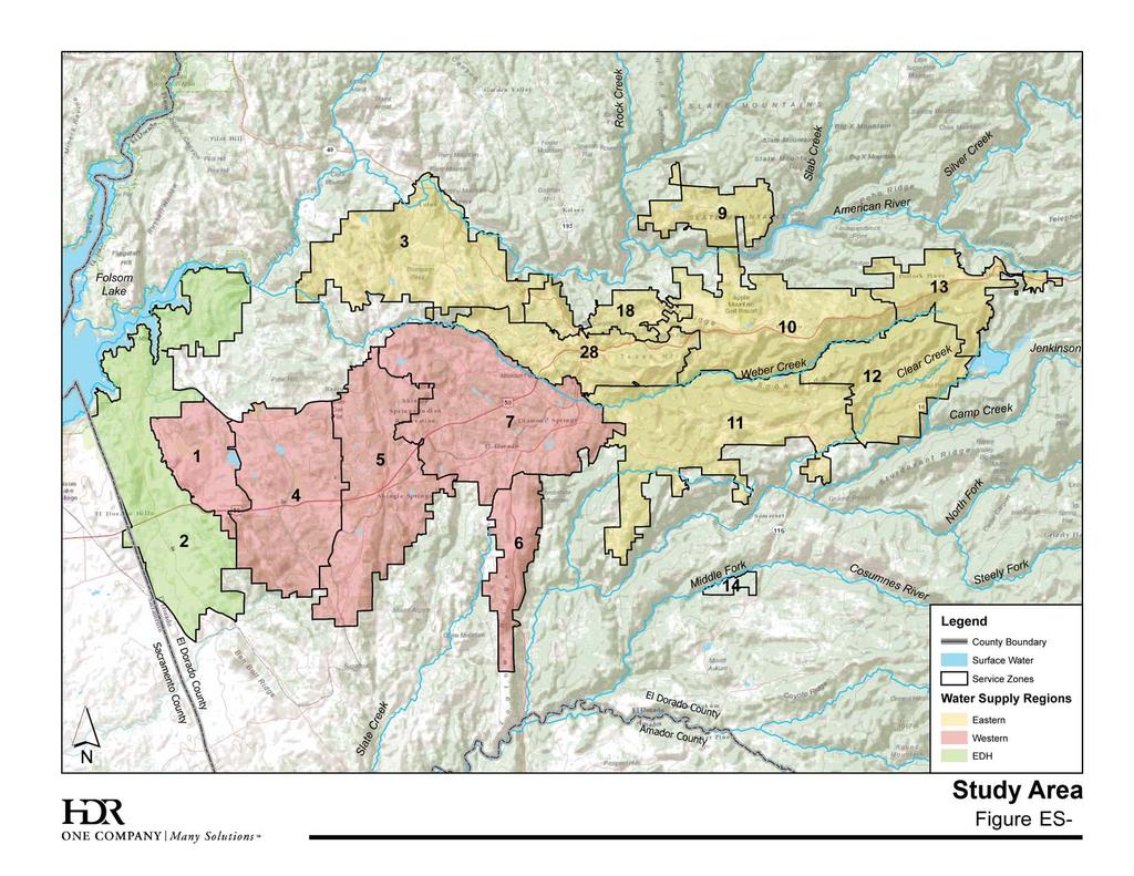
18 The following key issues were addressed in the development of the IWRMP: Water Supply Reliability Water Supply and Infrastructure Constraints Competing Water Resource Needs Future Role of Recycled Water Stakeholder workshops were conducted in 2009, 2010, and 2012 to inform and involve stakeholders interested in the project. These workshops included discussion of the project vision, objectives, and key issues, and provided interested parties with an overview of the project s basis of planning and assumptions. Stakeholders were also invited to provide input on future water supply concepts and the preliminary evaluation of alternatives, all of which was then incorporated into the planning process. Water demand projections provide the basis for comparison with available supply to define the need for future supply augmentation and capital improvements. Water demand projections were developed based on recent historical water demand data, planned land uses and land use unit demands, and estimated system losses and authorized uses. El Dorado County General Plan land uses and adopted Specific Plan land use information were used as the foundation for projecting future demands. These land uses reflect the County s plans and policies and they have been through rigorous public and environmental review. The District s annual water diversion in 2008 reached 46,766 ac-ft and is projected to increase to between 55,140 and 61,040 ac-ft by 2030 and to approximately 88,144 ac-ft at buildout, as shown in Figure ES-2.
19 The District s contiguous service area is divided into 3 water supply regions, the El Dorado Hills Region, Western Region, and Eastern Region, as shown in Figure ES-1. These regions are further divided into 14 service zones. In addition, the District has two satellite water systems in Strawberry and Outingdale. The District s existing sources of water include both surface water and recycled water. The potable water system has three principle points of diversion that deliver raw water to the system: 1) District owned and operated Sly Park Dam and Jenkinson Lake; 2) District owned and operated El Dorado Hydroelectric Federal Energy Regulatory Commission (FERC) Project 184 (Project 184) at Forebay Reservoir; and 3) Folsom Reservoir via two United States Bureau of Reclamation (USBR) water service contracts. Raw water diverted at these locations is treated at the Reservoir A Water Treatment Plant (WTP), Reservoir 1 WTP, and El Dorado Hills WTP, respectively.
20 Integrated Water Resources Master Plan Recycled water is produced at the District-owned and operated El Dorado Hills Wastewater Treatment Plant and Deer Creek Wastewater Treatment Plant and delivered for use in the El Dorado Hills and Cameron Park areas. ES-4 Alternatives Development and Evaluation A comprehensive planning process, illustrated in Figure ES-3, was used to develop and evaluate a wide range of alternatives for the District s water supply, treatment, conveyance and recycled water systems. The planning process focused on developing and screening initial concepts followed by the refinement and evaluation of more specific alternatives. The purpose of the screening process was to systematically narrow the range of possible concepts to focus detailed evaluations on the more feasible and promising options. The options that appeared most feasible were then packaged as alternatives and developed in more detail with specific facilities and costs identified. Preliminary Screening Alternatives Analysis Project Vision Project Objectives Concept Formulation Alternatives Preferred Alternative Combinations & Reformulations Combinations & Reformulations Evaluation Criteria Development Screening Criteria Evaluation Criteria Figure ES-3. Alternative Development and Evaluation Process ES-4.1 Description and Screening of Alternative Concepts The District has evaluated a number of projects to provide additional water supplies and required infrastructure needed to provide reliable supplies in drought periods and to meet the projected growth in water demand. The concepts considered in this IWRMP are El Dorado Irrigation District 6 Integrated Water Resources Master Plan April 23,
21 illustrated in Figure ES-4 and include new water supply, new reservoirs or expansion of existing storage reservoirs, recycled water, and other options such as groundwater banking and water transfers. The initial screening of concepts resulted in seven alternatives for further analysis. The alternatives were formulated around three general approaches for water supply delivery: gravity, pumped, and pumped / gravity combinations. These three approaches represent the range of delivery options and were intended to provide a comprehensive comparative evaluation of alternatives. The alternatives include three gravity supply options, one pumped option, and three options which combine both pumping and gravity supply: Alternative IA Gravity Supply Alternative IB Gravity Supply with Medium Alder Reservoir Alternative IC Gravity Supply with Small Alder Reservoir Alternative II Pumped Supply Alternative IIIA Pumped / Gravity Supply Alternative IIIB Pumped / Gravity Supply with White Rock Deferred Alternative IIIC Pumped / Gravity Supply with Medium Alder Reservoir The water supply, treatment and transmission system, and recycled water facilities for each alternative were developed and compared. The evaluation of the alternatives was based on the following economic and non-economic criteria: Minimizes Cost Maximizes Availability of Water Supplies Increases Dry Year Water Supply Reliability Opportunities for Other Benefits Provides Flexibility for Implementation Minimizes Environmental Impacts
22 Page Intentionally Left Blank
23
24 Page Intentionally Left Blank
25 Integrated Water Resources Master Plan ES-5 Recommended Water Resources Plan The recommended water resources plan is an integrated solution of Alternatives IA and IC which provides the greatest benefits at the least cost. Some of the major benefits of the recommended plan include: Provides the lowest total present value and has the lowest long-term cost per acrefoot compared to the other alternatives. Maximizes availability of water supplies. Increases dry year supply reliability. Optimizes supply and treated water production at the locations required for meeting dry year demands. Provides the potential for other benefits through a hydroelectric power component associated with Alder Reservoir. In addition to the benefits listed above, the recommended plan provides the District with flexibility by including both the White Rock Diversion and Alder Reservoir. Figure ES-5 is a schematic which illustrates the integration, development activities, and flexibility for the combined solution of Alternatives IA and IC. The major facilities required for the recommended plan are shown in Figure ES-6. Alternative IA Gravity Supply Planning, Design, and Construction of White Rock Diversion and New WTP New WTP Capacity up to 44 mgd No Design and Construct Expansion of New WTP New WTP Capacity up to 58 mgd Recommended IWRMP Plan Alternative IC Gravity Supply with Alder Reservoir Planning for Alder Reservoir Is Alder Reservoir Feasible? Yes Design and Construct Alder Reservoir Full Use of Reservoir A WTP up to 56 mgd Figure ES-5. Integration and Development of Alternatives IA and IC El Dorado Irrigation District 11 Integrated Water Resources Master Plan April 23,
26 Page Intentionally Left Blank
27
28 Page Intentionally Left Blank
29 The facilities would be time-phased to correspond with projected demand increases. The following phases have been established for addition of facilities and implementation planning: Phase 1: Phase 2: Phase 3: 2031 Buildout Figure ES-7 summarizes forecasted water demand and water production requirements for the El Dorado Hills Region, the Western and Eastern Regions, and the complete system. As shown in Figure ES-7, there is a range for projected demand growth. The upper bound of the range represents the high growth scenario and the lower bound represents the low growth scenario. For planning and capital budgeting, it was assumed that the initial phase of the new water treatment plant with a capacity of 10 mgd would be online by Future production capacity needs and timing beyond 2025 would be determined based on actual demand growth. Although Figure ES-7 shows that the new water treatment plant would be expanded from 10 mgd to 58 mgd, if Alder Reservoir is constructed, the existing capacity at Reservoir A WTP would be fully utilized, providing an additional 14 mgd. In that case, the new water treatment plant capacity would be expanded up to a maximum of 44 mgd. In addition, the future expansion of the new water treatment plant should be coordinated with growth in recycled water supply which may reduce the need for new water treatment capacity by approximately 5 mgd.
30
31 A summary of the required facilities by phase is presented in Table ES-1.
32 The estimated capital costs of the recommended plan are summarized by phase in Table ES-2. All costs are presented in 2012 dollars.
33 Table ES-3 summarizes the components of the recommended plan and their associated benefits. The two major components of the recommended plan include the White Rock Diversion with a new water treatment plant, and Alder Reservoir. In addition to providing a significant new water source to the District, the White Rock Diversion would also increase system reliability. Currently, the District supplies water from the east from Jenkinson Lake and Forebay Reservoir, and from the west from Folsom Reservoir. These supply sources are near the boundary extremes of the District, and as such, require long and significant conveyance facilities to provide treatment and delivery of water to customers. The White Rock Diversion would provide a third source of raw water independent of the existing sources. The new water treatment plant would be located near the center of the District's service area and uphill from areas with the highest demand growth, thereby facilitating gravity distribution of treated water in the future. Alder Reservoir would provide an estimated 11,250 AF of new supply each year and implementation of this project would improve supply reliability during dry year conditions and facilitate the full use of existing production capacity at the Reservoir A WTP. In addition, Alder Reservoir has a potential hydroelectric benefit, estimated at approximately 56,700 MWh per year when considering the combined generation at a new Alder Reservoir powerhouse and the increase in El Dorado Powerhouse generation.
34
35 A recommended implementation schedule is presented in Figure ES-8. This implementation schedule covers Phases 1 and 2 through Future updates to this IWRMP will provide opportunities for addressing the timing of facilities beyond 2030 to buildout based on growth trends and other factors. As Figure ES-8 illustrates, the White Rock Diversion, new water treatment plant, and pipeline from the plant to the Valley View and Bass Lake Tanks are needed to be completed by However, if growth in demand increases more quickly, new water treatment production capacity and the associated conveyance facilities would be required before The following next steps are recommended for the implementation of this IRWMP: Financing. The recommended facilities should be incorporated into the Districts five-year capital improvement program in accordance with the proposed phasing plan. Specific project financing can then be addressed as part of the District s regular budgeting, rates, and facility capacity charges program updates. Feasibility Studies and Engineering. The technical work completed for this IWRMP provides a framework for the recommended facilities. Feasibility studies are required to finalize locations and alignments, refine design criteria and sizing, identify land requirements, and update cost estimates. Following completion of feasibility studies additional engineering will be required. Environmental Compliance. The recommended facilities will require compliance with the California Environmental Quality Act (CEQA) and possibly the National Environmental Policy Act (NEPA) to evaluate the environmental impacts of the projects. The required environmental compliance documents should be completed in conjunction with the engineering preliminary design studies. To facilitate implementation of the IWRMP, a programmatic environmental impact report should be considered as an initial step.
36 Permitting. Numerous federal, state and local permits will also be required for project implementation. The required permits will be identified during the preparation of the engineering preliminary design studies and environmental compliance documents. A permitting strategy should be developed to minimize project delays and potential mitigation costs. Coordination with Ongoing Projects and Programs. Implementation of the IWRMP should be coordinated with other ongoing projects and programs. Specifically, the IWRMP should be coordinated with the following: Water Conservation Programs Infrastructure Renewal and Replacement Programs Hydroelectric Development Regional Water Supply Projects or Programs Stakeholder Outreach. Stakeholder workshops were conducted during preparation of this plan. Continued successful implementation of the IWRMP recommendations will require ongoing, proactive stakeholder outreach. Future IWRMP Updates. The IWRMP should be updated in 2020 to adjust recommendations for facilities and timing based on actual growth rates, progress made in implementation of the recommendations, and potential new issues and opportunities.
37
38 Page Intentionally Left Blank
39 This Integrated Water Resources Master Plan (IWRMP) provides a comprehensive program that optimizes the use of potable water and recycled water resources for the El Dorado Irrigation District (District). A separate report was prepared for the Wastewater Facilities Master Plan (WWFMP). Together, these plans provide a roadmap for development of future infrastructure and maintenance of existing water, wastewater, and recycled water facilities. The District provides water to more than 100,000 people for municipal, industrial, and irrigation uses, as well as wastewater collection and treatment and recycled water services to meet the growing needs of its customers. As such, the District is one of the few California districts that provide a full complement of water-related services. The District contiguous service area encompasses approximately 220 square miles on the western slope of the Sierra Nevada mountains in El Dorado County. The service area is bounded by Sacramento County to the west and the Pollock Pines to the east, and ranges from 500 to more than 4,000 feet in elevation. The area north of Coloma and Lotus establishes the northern-most part of the service area, while the communities of Pleasant Valley and South Shingle Springs establish the southern boundary. The City of Placerville, located in the central part of the District, receives water from the District as a wholesale customer. The District also operates two satellite water systems in the Strawberry and Outingdale communities. The District is located in a region of sunshine in the summer, moderate to heavy precipitation in the winter, and wide temperature ranges. Strong flows of marine air from the Pacific Ocean result in heavy precipitation in the winter. Precipitation in the summer is generally limited to a few scattered thunderstorms during July. According to the Western Regional Climate Center Placerville Station, located centrally in the District, the
40 historical annual average precipitation is approximately 38 inches, with an average monthly precipitation during winter months of about six inches. Temperatures throughout the service area range from warm in the summer to cold in the winter, with average monthly temperatures of 75 F in July and 42 F in January. Evapotranspiration records, which measure the loss of water from the soil both by evaporation and by transpiration from the plants growing thereon, indicate average values ranging from 1.4 inches in December, to 9.0 inches in July. Low humidity usually occurs in the summer months, from May through September. The combination of hot and dry weather results in high water demands during the summer months. Over the years, the District has transitioned from serving mainly agricultural customers, to serving primarily residential, commercial, and industrial sectors, although agriculture remains a significant water user. The majority of growth in El Dorado County has occurred in the El Dorado Hills and Cameron Park areas, mirroring the steady increase in population growth of the Sacramento metropolitan area. From 2000 to 2009, the El Dorado County population increased by 13 percent from 157,079 to 176,075 residents. According to the El Dorado County 2007 Economic and Demographic Profile, El Dorado County s 2015 projected population is 218,200; however, that estimate was prepared before the economic downturn that occurred in El Dorado County residents employed within the District service area work in a variety of industries, including government, healthcare, retail trade, education, construction, manufacturing, agriculture, professional businesses, and hospitality services. The largest employers in El Dorado County are in the public sector, health care, data processing, and trade sectors. Most El Dorado County residents are within commuting distance of the greater Sacramento area, which offers employment in the defense and state government sector and more diversified employment opportunities such as computer technology, financial services, healthcare, and biotechnology. The largest percentage of the county employed civilian labor force works within El Dorado County.
41 Numerous studies have been conducted regarding the District s water supplies and demand, wastewater collection and treatment systems, and treated effluent disposal and reuse. To avoid a duplication of effort and to provide consistency with ongoing plans and programs, previous studies have been used in development of both the IWRMP and WWFMP. A selection of previous studies which form the basis for this Plan include: Evaluation of Water Supply Alternatives for El Dorado Irrigation District (1989) El Dorado Irrigation District (EID) Water Supply Master Plan, Administrative Draft (December 2001) 2004 El Dorado County General Plan (July 2004) Joint Benefit Investigation Plan Technical (JBIT) Analysis of Preliminary Alternatives (2004) El Dorado County Water Agency - Water Resources Development and Management Plan (April 2007) Recycled Water Master Plan (December 2002) Recycled Water Seasonal Storage Basis of Design Report (June 2009) 2008 EID Water Diversion Report (June 2009) 2008 EID Consumption Report (June 2009) 2009 EID Water Resources and Service Reliability Report (July 2009) 2010 EID Urban Water Management Plan Update (July 2011) 2012 EID Water Resources and Service Reliability Report (August 2012) Draft Water Rights Optimization Study (2012) Pertinent information from these studies is utilized through this IWRMP. A complete list of references is included in Appendix A.
42 The District s primary goal for this IWRMP is to develop an integrated water resources plan that optimizes the use of the District s water resources and provides a roadmap for cost-effective development of future infrastructure and maintenance of existing facilities. This goal, combined with California s current economic situation, limited water supply, environmental constraints, and climate change, necessitates the need for a unified project vision. The following vision statement was developed by the District, stakeholders, and the consultant team. Similar to many water agencies in California, the El Dorado Irrigation District (District) desires to maintain its current level of service while preparing for future growth in an environmentally and fiscally responsible manner, while also considering the impacts of aging infrastructure systems and the uncertainties of climate change. The District sees the Integrated Water Resources Master Plan and Wastewater Facilities Master Plan Project as being the mechanism to address future water supply, infrastructure, and replacement needs in an integrated fashion. To achieve the project vision, the following specific objectives were established: Define, balance, and integrate the District s water resources. Develop a reliable, long-term water resources program which considers existing water supply, future demand, hydroelectric power generation, and environmental and economic constraints. Define the long-term role of recycled water within the District s water resources portfolio. Identify and implement approaches to address future constraints, which may impact the District s service to its customers.
43 Identify the steps needed to support the recommended water resources master plan. Develop integrated and prioritized water, wastewater, and recycled water system capital improvements that are consistent with the District s long-term goals and objectives. Coordinate water, wastewater, and recycled water system improvements with the recommended replacement activities to provide the basis for an affordable sustainable and complete capital improvement program. Identify triggers which may cause the District to adjust the recommended program. The following is a description of key issues that were addressed in the development of the IWRMP. Residents of El Dorado County (County) served by the District depend on surface water from the watersheds of the Sierra Nevada for their water supply. The Sierra Nevada snowpack serves as natural storage for much of the region s annual precipitation. These watersheds can experience large variations in annual precipitation and the resultant water supply. The State of California (State) has historically experienced significant droughts, and climate change may increase the frequency and severity of droughts in the future, resulting in reduced snowpack. The projected population growth and increase in water demands in the County will amplify the severity of drought impacts. In addition, as a result of supply limitations during dry years and those imposed by environmental constraints, the reliability of the Bureau of Reclamation s (USBR s) Central Valley Project (CVP) surface water supplies has been impacted. This uncertainty can create challenges in managing the District s other water supply sources. It is likely that the reliability of CVP surface water supplies will continue to decline.
44 Several ongoing planning processes in the Sacramento-San Joaquin River Delta threaten to further complicate management of District water supplies and/or impact the District s water supply reliability by requiring the use of water from sources upstream of the Delta to meet environmental or other in-delta needs. Such processes include the Bay Delta Conservation Plan, the Delta Stewardship Council s Delta Plan, and the State Water Resources Control Board s Bay-Delta Water Quality Control Plan. Therefore, considering the potential impacts of climate change, coupled with the reduced reliability of CVP and other supplies, the long-term water supply plan must consider both projected growth and supply reliability. As shown on Figure 1-1, the study area, located on the western slope of the Sierra Nevada, is primarily located in two major watersheds: the South Fork of the American River in the north and the North Fork of the Cosumnes River in the south. The District is hydrologically split between these two drainage systems by the Placerville Ridge and Highway 50. Due to the District s geographical layout and infrastructure configuration, water supplies serve specific areas to reduce pumping and infrastructure costs associated with delivery. Although the gravity and pumped systems are integrated, the District has divided the study area into three distinct water supply areas: El Dorado Hills (EDH) Region, the Western Region, and the Eastern Region. The EDH Region receives water pumped from Folsom Reservoir. For the purposes of this plan, the EDH Region was initially expanded to include Cameron Park (CP) due to the El Dorado Hills Water Treatment Plant expansion and the planned construction of the Oakridge pump station. The Western and Eastern Regions receive water by gravity flow from the District s eastern supply sources. The sources for the Western and Eastern Regions are almost fully utilized by existing average annual demand. New water supplies available for diversion from Folsom Reservoir are expected to exceed the need in the EDH/CP supply area. However, due to high pumping and infrastructure cost related to distance and elevation differences,
45 Folsom Reservoir may not be a viable source for the Western supply areas. Consequently, the long-term plan must consider alternative supplies that address both geography and infrastructure constraints. The District provides a wide range of municipal and industrial water supply, water resource-related recreation, hydroelectric power generation, wastewater treatment, and recycled water services throughout the County. These services have the potential to compete or conflict with one another or are constrained by regulatory and environmental requirements. For example, the District delivers raw water to the Reservoir 1 Water Treatment Plant using the same conveyance system that is used to generate hydroelectric power at the El Dorado Powerhouse as part of Project 184. The sale of power produced by Project 184 has important economic benefits to District customers. Therefore, the various competing water resources must be identified and balanced so that the District s resources are managed in a manner consistent with the District mission. Tertiary treated effluent from the District s two main wastewater treatment plants, the El Dorado Hills Wastewater Treatment Plant and the Deer Creek Wastewater Treatment Plant, is either discharged to surface water or recycled for irrigation and industrial uses. Further development of the recycled water program has been recommended to offset future potable water demands. Consequently, future recycled water demands must be evaluated to consider long-term water supply, resource needs, seasonal storage, anticipated future surface water discharge requirements, economic and environmental impacts, and District policies (e.g., Board Policy 7010 Authorized and Mandated Use of Recycled Water).
46 Page Intentionally Left Blank
47 Rock Creek Silver Creek Slab Creek American River!(!(!(!(!(!( Steely Fork Middle Fork Cosumnes River El Dorado County Amador County 50 }þ 49 }þ 49 }þ Jenkinson Clear Creek Weber Creek Camp Creek North Fork Scott Creek Slate Creek Folsom Lake El Dorado Hills Cameron Park Shingle Springs Pollock Pines Placerville Diamond Springs Legend County Boundary Surface Water Water Supply Regions Eastern Western EDH/CP El Dorado County Sacramento County Project Study Area and Water Supply Areas Figure 1-1
48 The District utilizes several different tools to manage and operate the water resources and infrastructure for which they are directly responsible. For example, multiple methods and models are used to analyze the District s water supplies, including the OASIS Model, developed by HydroLogics, Inc., and the WEAP model, developed by the Stockholm Environment Institute. Other examples include asset management and operations tools, such as the HANSEN database, the Geographic Information System (GIS) database currently being developed, and hydraulic modeling software for the District s water distribution, wastewater collection, and recycled water distribution systems. Although the use of these tools may be needed, the potential to combine these tools into a more comprehensive and District-wide application should be considered. Potential benefits associated with combining these tools include better coordination of facilities planning, minimization of maintenance requirements, encouragement for the exchange of ideas, and development of comprehensive strategies pertaining to common District resources. Detailed technical and economic analyses were completed to achieve the IWRMP objectives. The following tasks comprise the Scope of Services for this Master Plan: Project Vision and Basis of Planning Kickoff Meeting Summarize Related Work Problem Definitions Internal Stakeholder Workshop Establish Planning Criteria Evaluation Criteria and Methodology Integrated Water Resources Master Plan
49 Description of Study Area and Existing Water Resources and Systems Current and Projected Water Demands Identification of Demand-Side Management Alternatives Develop Water Supply Alternatives Evaluate Water Resources Alternatives Update Water System Hydraulic Model Develop Implementation Plan Describe Recommended Plan Finalize Institutional Requirements Develop Preliminary Financial Plan Define Permitting and CEQA Requirements Develop Implementation Schedule Project Management Stakeholder workshops took place in 2009, 2010, and 2012 to inform and involve stakeholders interested in the project. These workshops included discussion of the project vision, objectives, and key issues, and provided interested parties with an overview of the project s basis of planning and assumptions. Stakeholders were also invited to provide input on future water supply concepts and the preliminary evaluation of alternatives which was then incorporated into the planning process. Agendas, notes, and a list of stakeholders are provided in Appendix B. This master plan is divided into the following sections to address major topics associated with master planning activities:
50 Section 2.0 Existing Water Supplies and Systems. This section presents a discussion of existing water service regions, water supplies, water storage, treatment and distribution system, water supply management policies, regulatory requirements, and existing capital improvement program. Section 3.0 Basis of Planning. This section provides details of the study area, planning period, projected water demands, and availability of recycled water, as well as design criteria for the storage and distribution system. This section also addresses the impact of climate change on water supply and demand and the basis of cost estimates and a description of the integrated water resources planning approaches. Section 4.0 Existing and Projected Water Demands. This section provides projected water demand calculation methodology and compares future demand with available supply. Section 5.0 Identification and Screening of Water Resources Concepts. This section includes a comparison of water supply and demand, identifies water resources concepts, and provides results of concept screening. Section 6.0 Formulation of Water Resources Alternatives. This section provides details of the water resources alternatives selected for further evaluation. Section 7.0 Evaluation of Water Resources Alternatives. This section includes evaluation criteria for economic and non-economic factors considered in alternative evaluation, with a summary comparison of the alternatives. Section 8.0 Water Resources Plan Recommendations. This section provides the recommendations for water supply, water treatment, water transmission, recycled water, and provisions for coordination with hydroelectric development. Section 9.0 Water Resources Plan Implementation. This section describes the steps required for implementation of the recommended water resources plan.
51 Appendices (Bound Separately). Appendices A through E include references, technical memoranda, and other relevant data and background information. To conserve space and improve text readability, the following abbreviations have been used in this document: ac ac-ft ADD ADWF AFY AMR AWWA Board BMP BP C CCR Rule CDPH cfs CII County CP CUWCC CVP District DCWWTP DSM EDCWA EDH EDHWTP acre acre-feet average day demand average dry weather flow acre-feet per year automated meter reading American Water Works Association District Board of Directors best management practice District Board policies Hazen-Williams coefficient Consumer Confidence Report Rule California Department of Public Health cubic feet per second commercial/industrial/institutional El Dorado County Cameron Park California Urban Water Conservation Council Central Valley Project El Dorado Irrigation District Deer Creek Wastewater Treatment Plant Diamond Springs Main El Dorado County Water Agency El Dorado Hills El Dorado Hills Water Treatment Plant
52 EDHWWTP EDU EDWPA EID EPA FBRR FCC FERC FLIPS ft/sec GDPUD GHI GIS gpcd gpm HAA5 IWRMP JBIT LCR LF LT2 Rule MCL MCLG MDD MG mgd mg/l MMM MOU mrem MW MWh NTU El Dorado Hills Wastewater Treatment Plant equivalent dwelling unit El Dorado Water and Power Authority El Dorado Irrigation District U.S. Environmental Protection Agency Filter Backwash Recycling Rule Facility Capacity Charges Federal Energy Regulatory Commission Folsom Lake Intake Pump Station feet per second Georgetown Divide Public Utilities District Gold Hill Intertie Geographic Information System gallons per capita per day gallons per minute haloacetic acids Integrated Water Resources Master Plan Joint Benefit Investigation Plan Technical Analysis Lead and Copper Rule linear feet Long Term 2 Enhanced Surface Water Treatment Rule maximum contaminant levels maximum contaminant level goals maximum day demand million gallons million gallons per day milligram per liter Multimedia Mitigation (Program) memorandum of understanding millirem megawatt megawatt hour nephelometric turbidity unit
53 O&M OEHHA pci/l PG&E POM operations and maintenance Office of Environmental Health Hazard Assessment picocuries per liter Pacific Gas & Electric Pleasant Oak Main PRS pressure reducing station psi pounds per square inch RAND RAND Corporation SBx7-7 California Senate Bill 7, the Water Conservation Act of 2009 SEI Stockholm Environment Institute SMUD SOC SOFAR Stage 1 D/DBPR Stage 2 D/DBPR State SWRCB TAFY TCR UARP UCM USBR UWMP VOC WTP WWTP WWFMP Sacramento Municipal Utilities District synthetic organic contaminant South Fork American River Hydroelectric and Water Project Stage 1 Disinfectants and Disinfection Byproducts Rule Stage 2 Disinfectants and Disinfection Byproducts Rule State of California State Water Resources Control Board thousand acre feet per year Total Coliform Rule Upper American River Project Unregulated Contaminants Monitoring (Program) United States Bureau of Reclamation Urban Water Management Plan volatile organic contaminant Water Treatment Plant Wastewater Treatment Plant Wastewater Facilities Master Plan
54 Page Intentionally Left Blank
55 The District was formed on October 5, 1925 to provide irrigation water to farmers in the area and domestic water to the City of Placerville. Upon formation, the District assumed ownership of many old mining ditches. Over the years, District operations have expanded to serve growing residential, commercial, and industrial sectors, and subsequently, acquired a hydroelectric generating project. The District also provides wastewater and recycled water service to portions of the service area and operates and maintains several recreational facilities. For planning purposes, the District has divided its service area into three regions based on supplies and service areas, as described below and illustrated in Figure 1-1. EDH/CP Region: El Dorado Hills, Bass Lake, and Cameron Park Western Region: Shingle Springs, Logtown, El Dorado, and Diamond Springs Eastern Region: Pleasant Valley, Sly Park, Pollock Pines, Camino, Placerville, and Lotus/Coloma As previously described, for the purposes of this plan, the EDH/CP Region was initially expanded to include Cameron Park. The expansion of the EDH Region to include Cameron Park was consistent with the recommendations in the District s 2001 Master Plan, which envisioned an expansion of the El Dorado Hills Water Treatment Plant and the planned construction of the Oakridge pump station which would allow supply from Folsom Reservoir to be served to the Bass Lake and Cameron Park areas. Although the development of water demand forecasts and water supply alternatives was prepared using the regions described above, based on the recommended plan (described in Section 8), the regions were ultimately refined such that Bass Lake and Cameron Park were reassigned to the Western Region. The information presented in Sections 2 through 7 of this report refers to the regions described above. The refined regions, including water demands and growth assumptions, are presented in Sections 8 and 9.
56 The District s service area is divided into 14 contiguous service zones and two satellite water systems in Strawberry and Outingdale, as illustrated in Figure 2-1. The boundary between zones is typically defined by the pressure zones served by a specific storage tank or reservoir. The District s existing sources of water include both surface water and recycled water. The potable water system is composed of a main contiguous system, which serves over 95 percent of District customers, and two satellite systems. Three principle diversion points that deliver into the main system are 1) District owned and operated Sly Park Dam and Jenkinson Lake; 2) District owned and operated El Dorado Hydroelectric Federal Energy Regulatory Commission (FERC) Project 184 (Project 184) at Forebay Reservoir; and 3) Folsom Reservoir via two USBR water service contracts. The two satellite diversions include 1) potable water deliveries to Outingdale from the Middle Fork of the Cosumnes River, and 2) Strawberry from the South Fork American River. The District also diverts water into the Crawford Ditch from the North Fork of the Cosumnes River as a raw water source to serve ditch irrigation customers. Aside from the USBR contract, the District does not currently purchase water from any wholesale supplier. In the future, the District expects to purchase water wholesale from the El Dorado County Water Agency (EDCWA), which is pursuing a USBR contract under Public Law The location of these water supply sources is illustrated in Figure 2-2. The diversion rates, storage amounts, and other water rights information for each of the specific sources is summarized in Table 2-1. Each of the District s existing water supplies is described further in the following subsections.
57 Rock Creek Silver Creek Slab Creek American River Jenkinson Clear Creek Weber Creek Camp Creek North Fork Steely Fork Middle Fork Cosumnes River El Dorado County Amador County Scott Creek Slate Creek Legend County Boundary Surface Water Service Zones Water Supply Regions Eastern Western EDH/CP El Dorado County Sacramento County Folsom Lake Water Supply Regions and Service Zones Figure 2-1
58 Page Intentionally Left Blank
59
60 Page Intentionally Left Blank
61
62 The District obtains water from the North and Middle Forks of the Cosumnes River, Clear Creek, Squaw Hollow Creek, Park Creek, Camp Creek, Slab Creek, Weber Creek, and the South Fork American River in accordance with appropriative water rights, including pre-1914 rights. Some supply from appropriative water rights is diverted directly from rivers and creeks to be treated or conveyed as raw water. Other water is diverted to storage for subsequent treatment and distribution into the potable system. The District diverts water from the South Fork American River, its tributaries, and Echo Lake, in accordance with water rights for both power generation and consumptive uses that Pacific Gas & Electric Co. (PG&E) transferred to the District in Jenkinson Lake is the main storage reservoir in the District. It is formed by two earth and rock fill dams across Park Creek near Pollock Pines with a maximum capacity of 41,033 AF. The dam was constructed as a portion of the USBR Central Valley Project in With the 2003 transfer of ownership from the USBR of the Sly Park Dam and associated lands and facilities, the District not only operates and maintains the Jenkinson Lake and Sly Park Dam facilities, including recreational aspects, but holds the water rights. Jenkinson Lake receives inflow from Park, Hazel, and Camp Creeks, all of which are tributary to the North Fork Cosumnes River. With a drainage area of approximately 17.3 square miles, Park Creek and Hazel Creek contribute substantially to the total 45,920 AF of average annual runoff flowing to the reservoir. However, due to annual variations in precipitation and runoff, annual runoff can vary substantially, ranging from approximately 8 percent of average in 1977 to 276 percent of average in Water from Camp Creek can be diverted from a diversion dam on Camp Creek to Jenkinson Lake through the 7-foot diameter, 2,856-foot long Camp Creek tunnel. As much as 500 cfs can be diverted between November 1 and June 30. The District also has pre-1914 water rights for 12.5 cfs.
63 The average annual use from this facility is approximately 23,000 AF, though the District s annual water right is for 33,400 AF of total beneficial use. This water supply is used entirely within the District s contiguous service area. Under normal conditions, Jenkinson Lake is operated to maintain 14,000 to 18,000 AF of carryover storage each year. The outlet works at Sly Park Dam have a capacity of 125 cfs. Water is released to the Reservoir A Water Treatment Plant (WTP) for subsequent treatment, transmission, and distribution. Surface water from Folsom Reservoir is provided to the El Dorado Hills area. As previously described, the District has a number of water supply sources that are diverted at Folsom Reservoir, including 7,550 AF USBR CVP contract water and 4,560 AF by means of a USBR Warren Act contract. Each is described below. Under Contract No A-LTR1 with the USBR, the District is entitled to 7,550 AFY from Folsom Reservoir. The contract includes provisions for use in a particular area that generally encompasses the EDH/CP Region. Folsom Reservoir is operated by the USBR as part of the Central Valley Project (CVP), a multipurpose project that provides municipal and industrial water supply, flood control, and hydroelectricity. The El Dorado Hills County Water District entered into a USBR Contract in 1964 for water supply from Folsom Reservoir. The contract had a not-to-exceed limit of 37,600 AFY. When the District annexed the El Dorado Hills County Water District in 1973, the contract was assigned to the District, and subsequently, in 1979, an amendatory contract replaced the original 1964 contract and reduced the maximum annual supply quantity of Folsom Reservoir water to 6,500 AFY. In 1983, the USBR increased the maximum annual supply quantity from 6,500 to 7,500 AFY. The District also annexed and succeeded to a USBR Contract for 50 AFY to supply the Lake Hills area in El Dorado
64 Hills. In 2006, these two contracts were consolidated into a single 40-year USBR Contract with a maximum quantity of 7,550 AFY. While the USBR Contract can supply a maximum of 7,550 AFY during normal and wet years, the USBR utilizes a Shortage Policy to allocate supplies when full deliveries cannot be made. The USBR can impose shortages as a result of drought, unavoidable causes, or restricted operations resulting from legal and environmental obligations. The Shortage Policy indicates that during periods of water shortage, allocations for municipal and industrial water supply can be reduced to 75 percent of historic use subject to upward adjustments for population growth, use of non-cvp supplies, or extraordinary conservation measures. Thus, the USBR contract supply could be reduced from 7,550 to approximately 5,660 AFY or less depending on historic use. Previously, under severe water shortage conditions, the USBR has further reduced allocations in 1977, 1991, 1992, and 1994, when deliveries were reduced to approximately 2,200 AFY, and again in 2001, when deliveries were reduced to 5,354 AFY. Diversions from Weber Dam, Weber Creek, Slab Creek, and Hangtown Creek are available to be diverted at Folsom Reservoir with approximately 4,560 AF available each year from these sources. The District recently entered into a long-term Warren Act contract with the USBR to re-divert water right license No for Weber Reservoir and three pre-1914 appropriative water rights on Weber Creek (Farmer s Free Ditch), Slab Creek (Summerfield Ditch), and Hangtown Creek (Gold Hill Ditch) to Folsom Reservoir. The District abandoned the ditches that historically diverted from these supplies, and instead is making use of the water supply downstream at Folsom Reservoir. A Warren Act contract allows the use of federal facilities to take non-cvp water such as these supplies. The 40-year contract commenced on March 1, 2011 and has a maximum contract amount of 4,560 AFY, which reflects the best estimate associated with these various water rights in a normal water year. The contract total also assumes a 15 percent conveyance loss between the former points of diversion and Folsom Reservoir, which can
65 be adjusted at a later date by mutual agreement without amending the contract. The annual water diversion season is limited to April through November 15, and the water must be used for municipal and industrial purposes in the EDH/CP area. Unlike CVP contracts, this contract has no USBR-controlled shortage provisions. However, the actual yield is expected to vary from year to year based on hydrologic conditions, with the amount taken in any given year being based on the amount of water introduced into Folsom Reservoir by Weber Dam, Weber Creek, Slab Creek, and Hangtown Creek. The estimated dry-year yield associated with this contract is 3,000 AFY. Altogether the District s two Folsom Reservoir supplies contribute approximately 12,110 AFY to the District s supply during a normal year. Over the past 5 years, the District s annual diversions from Folsom Reservoir have averaged 6,890 AFY. The maximum and minimum diversions during this five year period were 9,171, and 5,785 AFY, respectively. 1 The District acquired Project 184 from PG&E in Project 184 includes reservoirs and associated dams, 24 miles of canals, a 21 megawatt (MW) powerhouse, and other ancillary facilities. Prior to the transfer of ownership and water rights, the District purchased water from PG&E and its predecessor, Western States Gas and Electric Company. The original water rights claims date back to 1856, with additional claims being filed in the 1860s and 1870s. The water rights for diversions from Echo Lake were established in 1880 in a California Supreme Court decision. Then, in 1918, the California Railroad Commission (predecessor to the California Public Utilities Commission) recognized the use of water from the El Dorado Canal for irrigation and domestic purposes.
66 The sources of this water supply include natural flows in the South Fork American River and its tributaries, and stored water in Silver, Aloha, Echo, and Caples Lakes. Except for a small diversion to serve the Strawberry satellite service area, the supply is diverted from the South Fork American River at Kyburz and is conveyed via the El Dorado Canal to the El Dorado Forebay. Some additional water is obtained by diversions into the El Dorado Canal from streams tributary to the South Fork American River. Water diversions of up to 156 cfs can be made from the South Fork American River at the diversion dam. These diversions are then supplemented by tributary flows into the El Dorado Canal en route to the Forebay. In addition to these direct diversion rights, the District also has pre-1914 diversion and storage rights associated with portions of the waters stored in Silver Lake, Caples Lake, and Lake Aloha and all of the waters stored in Echo Lake. El Dorado Forebay is filled by the surface water supply from the Project 184 facilities upstream in the South Fork American River basin and at Echo Lake. The District has a consumptive water entitlement of 15,080 AFY delivery at the Forebay. The entitlement is a pre-1914 water right, and diversions are made in compliance with the 40-year FERC Project 184 operating license issued to the District in October Since the full entitlement can be provided in all years, including the most severe historic single dry year 1977, this source of water is considered assured, and not subject to shortage from hydrologic droughts. Historically, this source has experienced temporary interruptions from damage to the conveyance system caused by forest fires, floods, and landslides. The District can also divert water from these sources into Jenkinson Lake via the Hazel Creek Tunnel. The Hazel Creek Tunnel originates at the El Dorado Canal and extends 2,200 feet and discharges to Hazel Creek, a tributary to Jenkinson Lake. Although the 8- foot horseshoe-shaped tunnel has a design flow capacity of 160 cfs, flows are limited to 30 cfs to prevent streambed scour in Hazel Creek. Over the past 5 years, the District s annual diversions from Project 184 Forebay Reservoir have averaged approximately 11,200 AFY. The District s maximum and
67 minimum diversions from this particular water source during this five-year period were 15,030 and 7,069 AFY, respectively. The EDCWA and the District applied to the State Water Resources Control Board (SWRCB) to obtain water rights for consumptive use of waters previously stored and released for power generation from Caples Lake, Silver Lake, and Lake Aloha, as well as certain direct diversions from the South Fork American River, all of which have been used by Project 184 for hydroelectric power generation or instream flows. The EDCWA later assigned all of its water under this application to the District. The SWRCB granted the right to appropriate 17,000 AFY of water. Permit allows the District to make direct diversions from the South Fork American River at Folsom Reservoir; to store in Caples, Silver, and Aloha Lakes; and to redivert the water released from storage. The sole approved point of take is at Folsom Reservoir. The water right authorized under Permit is for diversion and consumptive use anywhere within the District s contiguous service area. There are no cutback provisions on this supply. The District is currently pursuing a phased Warren Act contract with the USBR to make use of a portion of this water right at Folsom Lake. The District retains pre-1914 water rights for direct diversion from the North Fork Cosumnes River, Clear Creek, and Squaw Hollow Creek for serving the Crawford Ditch System. The system was acquired by the District from the Diamond Ridge Water Company in The Crawford Ditch is a conveyance system of pipes, siphons, lined and unlined canals, extending approximately 19 miles from the North Fork Cosumnes River to Reservoir 7 near Squaw Hollow. The Crawford Ditch consists of three segments which supply untreated irrigation water along the ditch system. It is a separate system, not connected to the District s contiguous water system, and thus, it is not included in firm yield calculations of potable water.
68 A maximum of up to 15 cfs can be diverted from the North Fork Cosumnes River, below its confluence with the Steely Forks, into the North Fork Extension segment of the Crawford Ditch System. The water can then be supplied for irrigation purposes in the North Fork Extension and Camp Creek segments of the ditch. Additional water from Clear Creek is used to augment the ditch flows to serve the Clear Creek segment which flows year-round. Water diverted at Clear Creek into the Clear Creek segment consists of a mix of natural Clear Creek flows and supplementary water released from Jenkinson Lake. The released water also satisfies a District obligation to provide aesthetic flows in Clear Creek. The former Camp Creek point of diversion at the Camp Creek Ditch has been moved upstream to the diversion dam at the Camp Creek Tunnel, which diverts water to Jenkinson Lake. Since that time, the pre-1914 Camp Creek water right of 12.5 cfs has been used to help fill Jenkinson Lake. Approximately 5,000 AFY is available for diversion into the Clear Creek segment from the natural Clear Creek flow at the diversion dam. Similar to the North Fork Extension, not all the water diverted into the Clear Creek segment is available for beneficial uses due to conveyance losses. The flows in the Crawford Ditch system are regulated to provide sufficient water at the end of the Clear Creek segment for release to Squaw Hollow Creek for rediversion into the East Diamond Ditch, located at the diversion dam on Squaw Hollow Creek. Releases can also be made to the siphon and pipeline serving the Reservoir 7 Water Treatment Plant, which is not currently in use. Direct diversions of water from Squaw Hollow Creek to the East Diamond Ditch are also made in accordance with the District s pre-1914 water rights. The District holds a 1933 appropriative water right for direct diversion from the Middle Fork Cosumnes River serving the Outingdale Subdivision. The original water right permit 4071 for this supply was issued by the State of California in 1933 to predecessors C.T. Oeste and later the Outingdale Water Company in the amount of 104 AFY. The
69 water system was transferred to the District in 1970 when the subdivision was annexed to the District, and included the accompanying water rights. Under the terms of the water right permit, the water was to be put to full beneficial use by December However, the subdivision has not reached build out conditions, and thus the District has requested extensions to allow it to develop and reach the level of consumptive use originally requested in the water right application. This water supply is an independent satellite potable system and therefore does not contribute to the potable firm yield calculation. The District produces recycled water at the El Dorado Hills Wastewater Treatment Plant (EDHWWTP) and the Deer Creek Wastewater Treatment Plant (DCWWTP). The water quality produced at these facilities meets the California Department of Public Health (CDPH) Title 22 requirements for unrestricted body contact uses. Recycled water from the EDHWWTP has been used for industrial purposes and golf course irrigation since Recycled water from the DCWWTP has been used for golf course, landscape, and road median irrigation since The distribution systems from the two reclamation plants were connected in 1997, such that recycled water could be transferred between the two systems. Today, the District also provides recycled water for commercial uses and for residential irrigation. Annual recycled water production capabilities are based on the total wastewater flow to the DCWWTP and EDHWWTP, uses and losses which occur within each wastewater treatment plant, inflow and infiltration, and a minimum discharge of 1.0 mgd of treated effluent to Deer Creek as mandated by the SWRCB. The average recycled water production between 2008 and 2012 was approximately 2,615 AFY. In 2008, the average dry weather flow at the DCWWTP was 3.01 mgd and at the EDHWWTP, the average dry weather flow was 2.93 mgd. Based on these values, and using the methodology for estimating recycled water production capabilities for the
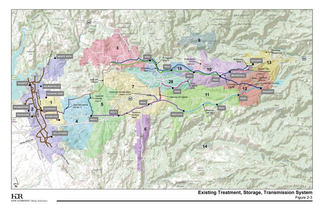
70 Seasonal Storage Project 2, it is estimated that a total of 6,135 AFY could be available if treated effluent was stored year round. Of this combined total, 2,830 and 3,305 AFY could be produced by the DCWWTP and EDHWWTP, respectively. By comparison, total recycled water demands in 2008 were approximately 3,360 AFY which equates to approximately 55 percent of the potential supply. However, it is noted that peak recycled water demands cannot be met solely with treated effluent production at the EDHWWTP and DCWWTP, thus supplemental water is required. In 2008, approximately 455 ac-ft of potable supplementation was provided. The District has decided that the recycled water supply deficit will be met by potable water supplementation until additional recycled water supply is available. Maximum day potable water supplementation has ranged between 1.5 and 3.0 mgd over the past five years. Previous estimates, developed as part of the District s Recycled Water Seasonal Storage Project, indicate that maximum potable water supplementation could increase to as high as 8.5 mgd based on buildout of the El Dorado Hills recycled water system if a seasonal storage reservoir is not constructed. The District currently relies on surface water to meet its entire potable water demand. This section identifies the treatment, storage, and transmission and distribution facilities which provide water to the service area, as illustrated in Figure 2-3. The following sections provide descriptions of the three main WTPs in the District s system: Reservoir 1 WTP Reservoir A WTP El Dorado Hills WTP
71
72 Page Intentionally Left Blank
73 Reservoir 1 WTP, shown in Figure 2-3, was originally constructed in 1962 and subsequently had a filter upgrade in The Reservoir 1 WTP treats water from the South Fork of the American River via Forebay Reservoir and supplies up to 26 mgd of potable water to customers throughout the service area. Raw water is diverted at the El Dorado Forebay where it travels through 3 miles in the Main Ditch to the Reservoir 1 WTP. The Main Ditch also includes customers receiving raw water. A raw water pump station at the Reservoir A WTP allows raw water to be pumped to the Reservoir 1 WTP via the Sly Park Intertie, providing a backup raw water supply to the Reservoir 1 WTP in the event that the El Dorado Forebay supply is not available. Currently the pump station is out of service. The District also uses the Moose Hall pump station to move treated water to the Reservoir 1 area from Reservoir A. A process flow diagram of the Reservoir 1 WTP is shown in Figure 2-4. Treatment processes include a manually-cleaned trash screen, automatically-cleaned bar screen, flocculation tanks, sedimentation basin, dual-media gravity filter, and chlorination. Sludge from the sedimentation basin is pumped to the sludge lagoons for thickening and drying, and filter backwash is pumped to the backwash storage tank for recycling to the front of the WTP. The Reservoir A WTP, shown in Figure 2-5, was originally constructed in Expansion and modifications were completed in 1998 and 2000, respectively. Reservoir A WTP treats water from Jenkinson Lake and supplies up to 56 mgd of potable water to the District s customers. Although the production capacity of the Reservoir A WTP is 56 mgd, the annual supply available for diversion at Jenkinson Lake during a normal year is limited to approximately 23,000 AF. Therefore, the average annual production of Reservoir A WTP is limited to approximately 21 mgd, with a maximum day production of approximately 42 mgd.
74 Main Ditch Mechanical Bar Screening Flow Meter Flocculation Sedimentation Basin (Cl 2 ) (Lime) (Polymer) (Alum) Backwash Return Pump Station Sludge Backwash Return Storage Tank Backwash Reservoir 1 Sludge Lagoon EDM 1 (Cl 2 ) (Cl 2 ) Filtration (Polymer) (Soda Ash) (Zn(PO 4 ) 2 ) The District s annual water right is for 33,400 ac-ft which equates to a maximum day production capacity of approximately 60 mgd. The outlet works at Sly Park Dam have a capacity of 125 cfs, or 80 mgd. A process flow diagram of the Reservoir A WTP is shown in Figure 2-5. Treatment processes include chemical addition, a rapid mix vault, dual-media gravity filters, and chlorination. Filter backwash wastewater is piped to an equalization basin and pumped to settling/drying beds.
75 Sly Park Intertie To Reservoir 1 WTP To Sly Park Hills Pressure Zone Jenkinson Lake Rapid Mix Vault Gravity Filters Chlorine Contact Basin Clearwell Reservoir A Pleasant Oak Main (Cl 2 ) (Polymer) Camino Conduit (Cl 2 ) (Cl 2 ) (Lime) (Zn(PO 4 ) 2 ) Backwash Waste Settling/Drying Beds Backwash Equalization The EDHWTP, shown in Figure 2-3, treats raw water from Folsom Reservoir to supply potable water to the El Dorado Hills service zone. The EDHWTP was originally constructed in 1960, with a capacity of approximately 6 mgd. The plant was subsequently expanded to 12 mgd in 1993, 14 mgd in 2001, 16 mgd in 2002, and the most recent expansion was recently completed to increase the plant s rated capacity to 26 mgd. As shown in Figure 2-6, treatment processes at the EDHWTP include raw water pumping, chemical addition facilities, clarifiers/filters, and disinfection in a clearwell. Treatment of backwash from the filters includes storage, chemical addition, and plate settlers. A series of high service water pumps distribute potable water to the distribution system.
76 (Cl 2 ) (NaOH) Raw Water Equalization (Polymer) (Alum) Folsom Lake Static Mixer Back- Wash Supply Tank Clarifier Gravity Filter Units 3-6 Clarifier Gravity Filter Units 1-2 (Cl 2 ) Plate Settler Storage Tank Solids to Sewer Backwash Equalization To EID Customers (NaOH) Chlorine Contact Basin Clearwell (Zn(PO 4 ) 2 )) The 2008 production of the District s water treatment plants is shown in Table 2-2. The calculated peaking factors are approximately 2.0 for each plant. EDHWTP had a slightly higher factor of 2.3; however, the plant was shut down during February and March, resulting in the slightly higher peaking factor. Thus, the peaking factor for EDHWTP was adjusted to 2.0. The Reservoir 1 WTP was also essentially shut down between October and December; however, that shutdown represents typical operations for the District, so no adjustments were made.
77 The District s transmission system is supplied by three water treatment plants, with each subsystem identified by its water supply source: Reservoir 1 WTP Subsystem Reservoir A WTP Subsystem EDHWTP Subsystem These three subsystems are interconnected and make up the District s transmission system. The following is a description of each of these transmission subsystems. A hydraulic profile of the transmission system is presented in Figure 2-7.
78 Water treated at Reservoir 1 WTP is stored in the adjacent Reservoir 1 storage reservoir from which it flows by gravity to Reservoir 2/2A and the town of Camino. Water is also pumped to the Pollock Pines Reservoir via the Sportsman pump station to customers at higher elevations. From Reservoir 2/2A, El Dorado Mains (EDM) 1 and 2 continue westward conveying water through Placerville into the Gold Hill area. Prior to reaching the Gold Hill area, three major storage facilities (Reservoirs 3, 4, and 5) are situated along EDM 1 and EDM 2. These storage facilities are utilized to reduce the pressure in the pipeline and provide system storage. At Reservoir 3, EDM 1 Lateral 8.0 South begins and continues in a southerly direction around the southeastern edge of Placerville through Reservoir 6. The City of Placerville has turnouts along this lateral that deliver water to the City s water distribution system. The Highway 49 Intertie connects downstream of Reservoir 6 and extends in a southerly direction to the Diamond Springs Main (DSM) near Diamond Springs. In the latter half of the 1970s, EDM 2 was constructed to serve as a parallel pipeline to supplement the hydraulic capacities of EDM 1 and the supplies of Reservoirs 3, 4, and 5. EDM 2 begins at Reservoir 2A in Camino and extends in a westerly direction, generally following the alignment of EDM 1. EDM 2 also terminates in the Gold Hill area. In the mid-1980s, the District constructed the Gold Hill Intertie (GHI), which connects to EDM 2 in the Gold Hill area and extends to the Cameron Park area along Green Valley Road. This pipeline provides water to the Cameron Park/Shingle Springs service zones. Leg A of the GHI connects with the DSM and extends from Green Valley Road to Reservoir 12. Another extension of the GHI, the AD#3 Conduit, extends from Bass Lake Road to the Bass Lake Tanks and to the Oakridge Tank in the El Dorado Hills service zone.
79 2-7
80 Page Intentionally Left Blank
81 Water treated at the Reservoir A WTP is conveyed to Reservoir A adjacent to the treatment plant. A small portion of the finished water is pumped to the Sly Park Hills Pressure Zone where the water is used to serve customers at higher elevations. From Reservoir A, water is distributed based on system demands northwest into Reservoirs 2 and 2A in the Reservoir 1 subsystem via the Camino Conduit, and southwesterly via the Pleasant Oak Main (see Figure 2-3). Water flowing in the Pleasant Oak Main is conveyed through Reservoirs B and C. Water leaving Reservoir C flows westerly to Reservoir 7A and 7B, where it enters the DSM where it is conveyed through Reservoir 8 to Reservoir 9. The Highway 49 Intertie and Lateral 3.3 North of the DSM (Lateral 3.3 N) connect to the DSM between Reservoirs 8 and 9. As noted previously, the Highway 49 Intertie connects the Lat. 8.0 S of the Reservoir 1 subsystem with the DSM of the Reservoir A subsystem. DSM Lateral 3.6 N extends northwesterly from the DSM, serving commercial areas along Missouri Flat Road and continues until connecting the Greenstone Country pipeline and to the GHI of the Reservoir 1 subsystem in the Greenstone area. From Reservoir 9, the DSM conveys water in a westerly direction through the Diamond Springs/El Dorado, Logtown, Shingle Springs, and Cameron Park service zones. The DSM terminates at Reservoir 12 located east of Cameron Park. Water treated at the EDHWTP is pumped and distributed via transmission mains which convey water to tanks throughout the El Dorado Hills area, as shown in Figure 2-3. The Salmon Falls Tank, Monte Vista tank, Highland View Tank, Promontory Tank, Ridgeview Tank, Oakridge Tanks, Bass Lake Tanks, and Valley View Tanks serve demands within their zones. From the treatment plant, water is conveyed west to Salmon Falls Road. The pipeline then follows Salmon Falls Road to the Salmon Falls and Monte Vista Tanks. A series of
82 pipelines also convey water from the treatment plant to the central and west parts of El Dorado Hills. The pipeline running south along El Dorado Hills Blvd conveys water to the Promontory Tank and Ridgeview Tanks and down to customers south of Highway 50. Another pipeline runs south along Silva Valley Parkway providing water to the Highland View Tank and Oakridge Tanks and to customers south of Highway 50 where it meets the El Dorado Hills Blvd pipeline. The El Dorado Hills Blvd and Silva Valley Parkway pipelines are also connected by an 18-inch pipeline that runs along Harvard Way. Water is conveyed to the Serrano development by a pipeline that connects to the Silva Valley Parkway pipeline and conveys water to the west along Serrano Parkway to Bass Lake Road and the Bass Lake Tanks. A pipeline along Greenview Drive loops around the Serrano development and connects to the Serrano Parkway pipeline and the Highland View pipeline. South of Highway 50, the El Dorado Hills Blvd and Silva Valley Parkway pipelines meet at White Rock Road. Pipelines along White Rock Road and Latrobe Road convey water to the commercial development along Latrobe and to the Valley View and Blackstone developments. Table 2-3 provides a summary of the transmission system pipelines. Each of the service zones is subdivided into pressure zones which represent the area served by each reservoir or tank. Key storage facilities are shown in Figure 2-3. Table 2-4 provides a summary of storage capacities and construction dates for the existing storage facilities.
83
84 Existing and future potable water system storage requirements were evaluated in the Storage Evaluation for Potable Water System (Owen Engineering and Management Consultants, 2002). In this evaluation, average day demand (ADD) and maximum day demand (MDD) were determined for each service zone. These estimates included
85 consumptive and irrigation demands, and unaccounted-for water (water system line losses). Existing and buildout equalization, emergency, fire flow, and regulation storage requirements were then calculated for each storage zone based on criteria shown in Table 2-5. In addition to the future storage requirements, District s 2008 Storage Reservoir Floating Cover Replacement Report evaluated the seven existing reservoirs with hypalon lining and covers. The District is following the recommendation for interim repairs for the covers until those seven reservoirs are ultimately replaced.
86 The CDPH is the primary agency responsible for the enforcement of the federal and state Safe Drinking Water Acts and oversees the District s water system. The CDPH Drinking Water Program is part of the Division of Drinking Water and Environmental Management, and the Northern California Field Operations Branch of the Drinking Water Program oversees the District s water system. The CDPH performs field inspections, issues operating permits, reviews plans and specifications for proposed facilities, enforces compliance with laws and regulations, monitors water quality, and promotes water system security. The CDPH also collaborates with the U.S. Environmental Protection Agency (EPA), SWRCB, and Regional Water Quality Control Board. A summary of existing and pending drinking water regulations issued by the CDPH and/or EPA is provided in Table 2-6. The District prepares a five year CIP which is updated annually. The 2013 CIP has approximately $85.8 million in improvements identified for 2013 through 2017, for an annual average of approximately $17.2 million. The District has more than thirty water related capital improvement projects planned for the time period, totaling more than $14 million. In addition, the District has 23 hydroelectric projects planned for the period, totaling more than $40 million. The remainder of the CIP is allocated to wastewater, recycled water, recreation, and general District projects.
87
88
89 The District operates two wastewater treatment plants, the DCWWTP and the EDHWWTP, which serve an estimated population of approximately 60,000 in the service area. The DCWWTP has a rated average dry weather flow (ADWF) capacity of 3.6 mgd; a minimum of 1 mgd is discharged to Deer Creek while the remaining flow is available for beneficial reuse. EDHWWTP has a rated ADWF capacity of 4.0 mgd; treated effluent from this facility is discharged to Carson Creek or stored in the adjacent 70 million gallon (MG) storage reservoir and reclaimed for beneficial reuse. Recycled water from both WWTPs is stored and distributed through an interconnected network or pipelines, pumping stations, and storage tanks. Recycled water is used for irrigation of residential developments, schools, parks, golf courses, and commercial/industrial landscaping in the El Dorado Hills and Deer Creek Sewersheds. Recycled water is an important element of the District s water resources portfolio. Section 5.0 of this IWRMP evaluates and recommends alternatives for future water supplies, all of which include a recycled water component. Common elements for program solutions within the water, wastewater, and recycled water facilities are integrated in both the IWRMP and the WWFMP. These common elements provide the framework for meeting the project vision and objectives identified in Section 1.0.
90 Page Intentionally Left Blank
91 This section provides the information used in the development of concepts and alternatives for the IWRMP. The basis of planning includes assumptions regarding the study area, planning period, land use, recycled water availability, and cost estimates. In addition, this section summarizes pertinent District policies, District design criteria, and relevant ongoing studies. Climate change assumptions are also addressed. The integrated water resources planning approach is summarized at the end of this section. The Study Area is illustrated in Figure 1-1 and includes lands that are both currently served and those which are planned for future development that may require municipal and industrial water supply, wastewater collection and treatment, and/or recycled water services. The Study Area includes the area used for the District s 2001 Administrative Draft Water Supply Master Plan and additional lands that have been annexed to the District since As described in the 2001 Administrative Draft Water Supply Master Plan, the Study Area was developed based on land use densities, geographical limitations, and estimates regarding feasible expansions to the District s infrastructure. Specifically, the Study Area excludes some larger parcels (i.e., 5 acres or greater) and other areas that may require relatively high costs for service (e.g., significantly higher than normal infrastructure costs for extending the District s existing facilities) that are located within the District s service boundary. As shown in Figure 1-1, and as previously described, the Study Area is subdivided into three water supply regions: the EDH/CP Region, the Western Region, and the Eastern Region. The planning period for the master plan extends 20 years, from 2010 through The planning horizon of the adopted General Plan for El Dorado County was to 2025.
92 As described previously, project objectives include the development of recommended water, wastewater, and recycled water infrastructure needs to serve the growth defined by the County General Plan and the City of Placerville. The fundamental planning basis for developing water demands and projected wastewater flows is the planned land use presented in the County General Plan, including the Specific Plans developed for the communities of Bass Lake Hills, Carson Creek, El Dorado Hills, Northwest El Dorado Hills, Promontory and Valley View, and the water demands described by the City of Placerville s 2005 Urban Water Management Plan. The General Plan land uses are used to develop water demands and wastewater flows for the master plan as illustrated in Figure 3-1. The District is currently completing the Water Rights Optimization Study. This study will evaluate various options and provide recommendations for the best long-term economical method to meet water demands using current and future water supplies through optimization of existing points of diversion and potential new points of diversion. Operational strategies will be investigated to optimize existing and future water supplies to take full advantage of the District facilities while continuing to maximize water supply availability and hydroelectric power production. Available information and results from this ongoing study are included in the IWRMP.
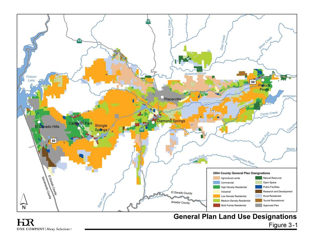
93
94 The District is governed by a five-member Board of Directors (Board) pursuant to Irrigation District Law (Water Code 20500, et seq.). The Board sets policy for the District and provides leadership on behalf of District customers. The purpose of these policies is to set forth the role of the Board and the responsibilities of the general manager and the general counsel in carrying out the terms and conditions under which the District provides services to its customers. In addition, the policies direct the operations and administration of the District in a way that ensures that services are provided at the lowest possible cost, consistent with District goals and objectives, and are equitably distributed among those benefited, or by another specific policy of the Board. The Board has the authority to interpret these policies and to rule on any point of contention that is not specifically covered herein. The following are the District Board policies (BP) related to the development of the master plan. BP 5010 Water Supply Management The Board is committed to provide a water supply based on the principles of reliability, high quality, and affordability in a cost-effective manner with accountability to the public. It is the policy of the Board that the District will not issue any new water meters if the Water Resources and Service Reliability Report indicates that there is insufficient water supply. When warranted by the findings of the report, the general manager will bring the possibility of restrictions on meter issuance to the Board s attention. Any such restrictions will be established pursuant to Water Code Section 350 et. Seq. of the California Water Code. BP 5030 Water Conservation It is Board policy to take reasonable and prudent measures to conserve all water and to adopt and implement water-use efficiency programs that will benefit its customers.
95 BP 5040 Drought Preparedness and Climate Variability The Board supports the adoption and implementation of a drought preparedness plan to ensure a proactive response to the impacts of drought conditions. Included in the planning effort is consideration of climate variability. BP 5050 Watershed Management It is Board policy to adopt and support watershed management strategies that will maximize water supply reliability and water quality. BP 7010 Authorized and Mandated Use of Recycled Water The District mandates the future use of recycled water, wherever economically and physically feasible, as determined by the Board, for non-domestic purposes when such water is of adequate quality and quantity; available at a reasonable cost; not detrimental to public health; and not injurious to plant life, fish, and wildlife. The type of use is defined in Title 22 of the California Code of Regulations. In general, the lands subject to mandatory recycled water use are defined in the most current version of the District s Recycled Water Master Plan. BP 8010 Hydroelectric System Management The District maintains and operates its hydroelectric generating facilities in a safe, efficient, and environmentally responsible manner, and in compliance with all applicable federal and state permits and regulations, the terms of the FERC license, and all related agreements. Hydroelectric power generation shall be compatible with the District s consumptive water supply operations. BP 8020 Additional Generation Opportunities The District shall seek to augment its electric energy and capacity revenue stream, and/or reduce its operational energy expenses, by adding new generation facilities whenever they are economically viable. In relation to FCCs, the District is committed to provide capacity for a reasonable rate of growth within its service area. FCCs will be charged to applicants for new service to cover the costs of services that include but are not limited to water filtration, sewage
96 treatment, recycled water, system storage, and transmission and distributions systems. Existing customers will not share in these costs. The General Manager is authorized to approve changes in fees, charges, fines, and deposits as warranted by the costs of providing services. Potable water design criteria are adopted from design criteria currently used by the District. Current information is provided online in the EID Document Library 3 The Board supports the adoption and implementation of a drought preparedness plan to ensure a proactive response to the impacts of drought conditions through Board Policy Included in the planning effort is consideration of climate variability. As a part of the Urban Water Management Plan (UWMP) update process, the District partnered with researchers from the RAND Corporation (RAND) and Stockholm Environment Institute (SEI) to apply new water planning tools and approaches for accommodating growing water supply needs, potential climatic changes, fire risk, and other challenges. These approaches are designed to significantly engage water agency staff, board members, and interested stakeholders. Changes in climate over the coming years and decades have the potential to impact water management activities. The potential for early run-off or reduced snowpack needed to fill upper elevation reservoirs are two of the climatic changes that could have a direct effect on District water supplies. These changes make it problematic to rely on recent historical records when making long-term plans, yet predicting future hydrologic conditions cannot be done with sufficient confidence to simply replace historical hydrologic conditions with an estimate of future conditions when evaluating water management strategies. The modeling builds on on-going hydrologic modeling and drought planning work by SEI
97 under a contract from NOAA and was intended to develop a methodology based upon robust decision making methodologies. The District hosted two workshops over a 24-month period to support the 2010 UWMP and companion project. In the workshops, participants discussed important threats, interacted with water system models designed to evaluate management plans, helped develop responses to identified vulnerabilities, and provided feedback on promising adaptation strategies. Workshop 1 included a discussion of issues facing the District and uncertainties that could impact the UWMP. RAND representatives presented ways that climate change modeling and forecasting could be used to analyze water management components, addressing a wide range of future uncertainties. Workshop 2 was an interactive modeling session to explore the performance of several management strategies against numerous future scenarios. Goals included describing the WEAP model, presenting results of static strategies against a range of future scenarios, and eliciting feedback and suggestions for model improvement and strategy augmentation. Future evaluations of climate change will be done using the WEAP model created under this partnership. Preliminary cost estimates will be developed for the infrastructure needs identified in the plan. Cost estimates will include initial capital, plus annual operations and maintenance (O&M) costs. A present worth analysis will be used to compare the economic impacts of competing alternatives using the parameters listed in Table 3-1.
98 Capital cost estimates will be prepared by applying unit costs and cost curve data to the estimated quantities or capacities for proposed improvement projects. Allowances will be added for contingency (30 percent) and engineering, administration, and permitting (25 percent). Higher allowances may be used for complex alternatives, projects, or facilities. For projects already in progress, actual bid data or established budgets developed by others will be utilized. When possible, construction costs will be based on actual bid data or estimates presented in prior studies adjusted to reflect current dollars and the size of the proposed facility. Where prior bid results or previous estimates are not available, new facility costs will be developed using techniques deemed appropriate for a project feasibility-level cost estimate (i.e., +25 percent, -15 percent). Construction costs will be limited to the following major facilities: Water: Diversion, storage, conveyance, treatment, transmission pipelines, and supporting infrastructure (e.g., pumping stations) Recycled Water: Conveyance, storage, distribution (10-inches and greater), and supporting infrastructure (e.g., pumping stations) O&M costs include those costs associated with new and existing facilities. Estimated annual O&M costs for new facilities will be based on historical District-specific or local agency data, or a percentage of the construction cost based on industry standards. All preliminary cost estimates will be adjusted to represent current dollars. The basis for the estimates will be the Engineering News Record (ENR) 20 Cities Construction Cost Index.


99 Integrated Water Resources Master Plan 3.9 Integrated Water Resources Planning Approach An integrated water resources approach is required to address the future water supply and infrastructure needs of the District. This comprehensive planning approach includes evaluation of existing supplies, forecasting future water demands, and development and evaluation of a range of water resources alternatives. The comprehensive planning approach is summarized in Figure 3-2. The plan development sequence includes a two step alternative screening process. Figure 3-2. Integrated Water Resources Planning Approach As illustrated in Figure 3-2, alternative screening and evaluation criteria have been tailored to meet the specific objectives established by the District. The screening and evaluation criteria are described in detail in Sections 5 and 7, respectively. El Dorado Irrigation District 85 Integrated Water Resources Master Plan March 31,
100 The following section of this report (Section 4) addresses existing demands and forecasts of future demands. Section 5 of this report describes the identification and screening of water resources concepts. Sections 6 and 7 present the formulation and evaluation of water resources alternatives. Sections 8 and 9 describe the recommended plan and implementation steps.
101 Water demand projections provide the basis for comparison with available supply to define the need for future capital improvements. Forecasting future water demand combines existing use factors, land use projections, growth rates, and the impact of water conservation as summarized in the following subsections. The detailed Water Demand Projections Technical Memorandum is included in Appendix C. A rigorous methodology was established for projecting future water demands for each of the District s water supply regions, shown in Figure 2-1 in Section 2, for use in long-term water supply planning. The methodology consisted of the use of GIS to manage parcel map shape files with land use designations for existing conditions, County General Plan (including specific plans) land use designations for vacant parcels, and the development and application of water use factors by land use for each service zone for future conditions. Water use factors were developed based on historical water demand within the District s service zones. Single family residential land uses, including high, medium, and low density, and rural residential, were assigned the density factors and water use factors shown in Table 4-1. The density factors represent the average density for each land use category, respectively, as described in the County s General Plan. The water use unit demand factors are based on the District s design standards and reflect the different demand behaviors associated with each of the three supply regions. For other land use types (e.g., commercial, industrial, and multi-family residential), data from the District s 2006 Consumption Report were used in combination with existing parcel data to generate use factors for each service zone, respectively. The year 2006 was selected as the basis from which to develop use factors because it was a wet water year; thus it is expected that water usage during 2006 reflected relatively typical behavior.
102 Use factors in Service Zones 1, 2, and 4 are generally higher than other zones, reflecting higher densities, warmer climate, and more intense use of nonresidential lands. Use factors for satellite Service Zones 14 and 15 were not included in the analysis; the use in these zones is expected to remain relatively constant throughout the planning horizon. Future water demands were calculated using the water use factors for each general plan land use type, as described above, and the total vacant acreage within the District s service area. Where applicable, land use from approved County Specific Plan land use maps was used to augment the General Plan land use map. The resulting land use map is shown in Figure 4-1. City of Placerville demand projections from their 2005 Urban Water Management Plan were included in future demands (as shown in Table 4-2).
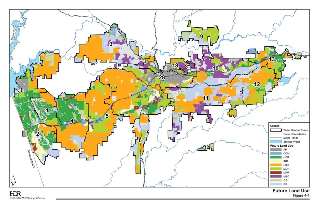
103
104 Page Intentionally Left Blank
105 Total production requirements include consumption, authorized uses, and system losses. Buildout water demands must also be phased over the planning period using projected growth rates as described in the following subsections. Although the District has an established program for identifying and accounting for most unbilled and other system losses, there are still pipeline leaks, unmetered uses, unauthorized connections, meter inaccuracies, and other losses that are difficult to specifically quantify. According to the District s 2009 Water Resources and Service Reliability Report, historical system losses have ranged from 12 to 15 percent over the previous ten years. Consistent with the District s methodology for calculating future water meter availability, as defined in the 2009 Water Resources and Service Reliability Report, system losses were projected at a fixed rate of 13 percent. Future reductions in unit water demands due to conservation savings are not included in the demand forecast. Conservation savings are considered as part of the future water supply alternatives analysis. Table 4-2 presents a summary of the projected water demands at buildout of the District s service area.
106 The use factors and buildout water demand projections were reviewed and compared with past District projections for consistency. The District s 2001 Administrative Draft Water Supply Master Plan projected buildout demands of 85,100 AFY and the 2005 Urban Water Management Plan projections for 2020 and 2030 were 73,000 and 89,000 AFY, respectively. The EDCWA Water Resources Development and Management Plan, prepared in 2007, projects future demands of 76,237 AFY at 2025 and 101,155 AFY at buildout. Since these previous studies were prepared, the District has made adjustments to the service area boundaries and system design criteria. Therefore, it is expected that the demands would be somewhat different. Future demands were also projected for each water supply region, as presented in Table 4-3. System losses of 13 percent were proportionally allocated to each water supply region; authorized uses are reported separately.
107 Water consumption for the historical period from 2000 to 2009 was evaluated to determine the average annual growth rate that could occur in the service area. The annual usage for all user categories was included in the analysis; the water consumption for the City of Placerville was not included. The 2009 data was excluded from the average due to the unusually large decline in water consumption, which was attributed to drought restrictions and higher than normal vacancy rates associated with the economic decline. The average growth rate for the District s service area was determined to be 2.5 percent based on the period from 2000 to This growth rate is also consistent with that included in the District s 2005 UWMP. The average annual growth rates for each water supply region, for the period 2000 through 2008, are shown in Table 4-4. The El Dorado County General Plan 2008 Housing Element had an average annual growth rate of approximately 2 percent through While this is lower than the rates presented in Table 4-4, it is expected that the average growth rate within the District s service area will be higher, particularly in the El Dorado Hills and Cameron Park areas, due to their proximity to Sacramento, as well as the population density and availability of water when compared to other, more remote areas in the County. The County s website 4 reports that the majority of El Dorado County s population growth since 1980 has been in the El Dorado Hills/Cameron Park area, and that the trend is expected to continue as transportation services and housing opportunities increase. Therefore, since the growth within the District has historically been focused more in the western portion of the service area, the historical growth rates for the three water supply regions were evaluated and used to project interim demands.
108 Recognizing that growth has slowed in recent years and due to the uncertainty associated with the rate at which future development will increase, the expected annual growth rate through 2020 was assumed to be lower than that between 2000 and The growth rates used to project future development are shown in Table 4-5. Using the total projected buildout demands presented in Table 4-3 and the growth rates for each supply region presented in Table 4-5, future demands were estimated at 5-year intervals (2005 through 2030). The results are presented in Table 4-6.
109 Using the water demand forecast and current available supply, comparisons were completed to identify future needs. Figure 4-2 summarizes the current annual water supply compared to projected demands. A comprehensive analysis of water supply and demand differences for various year types is provided in the EID Urban Water Management Plan 2010 Update. As shown in Figure 4-2, the District has sufficient water supplies to meet projected demands through 2030 under normal year hydrologic conditions. In the third year of a multiple dry year period, water supplies are sufficient to meet demands through Due to the uncertainty in water supplies associated with more restrictive environmental requirements, hydrologic variations due to climate change, and other factors, the District

110 must continue to investigate additional water supplies. The need for additional water supplies is to provide long-term dry year reliability as well as meet projected buildout water demands. Figure 4-3 summarizes the existing District water production capacity and the projected maximum day water demands. The water production capacity includes the three existing surface water treatment plants and recycled water produced and utilized in the EDH/CP Region. While the total water production capacity is sufficient to meet MDD projections through 2025, the location of production capacity does not correspond to the location of future demand increases. Table 4-7 summarizes the differences between the location of production facilities and the location and timing of projected MDD.
111 As described in Section 2 and as shown in Figure 4-3, the nominal treatment capacity of the Reservoir A WTP is 56 mgd. However, the supply in a normal year from Jenkinson Lake averages approximately 23,000 ac-ft. Under these normal year operations, maximum day production at the Reservoir A WTP would be limited to approximately 42 mgd. The District s annual water right is for 33,400 ac-ft which equates to a maximum day production capacity of approximately 60 mgd. The Reservoir A and Reservoir 1 WTPs are located in the Eastern Region and have a combined nominal production capacity of 82 mgd. Projected maximum day demand in the Eastern and Western Regions totals 45 mgd in 2020, 48 mgd in 2030, and 75 mgd at buildout. Therefore, excess production capacity in the Eastern Region is available for meeting a portion of the MDD in the EDH/CP Region, subject to limitations in the transmission system and available supply. The El Dorado Hills WTP has a capacity of 26 mgd. However, 2020 MDD in this region is 49 mgd indicating a production capacity deficit of 23 mgd. Recycled water provides approximately 5 mgd, leaving a water treatment plant capacity deficit of an estimated 18 mgd for Furthermore, the EDH/CP Region is forecast to have the greatest increase
112 in demand of all the three regions through Projected MDD in the EDH/CP Region is expected to nearly double from 41 mgd in 2010 to 76 mgd by By comparison, the combined MDD in the Eastern and Western Regions is projected to increase from 43 mgd in 2010 to 48 mgd in This comparison of water production and projected MDD illustrates one of the fundamental water supply problems facing the District. That is, how to best balance water supply, treated water and recycled water production, transmission, and demands. The following sections of this IWRMP identify and evaluate the potential water resources alternatives to address this need.
113 Integrated water resources planning includes consideration of both demand-side and supply-side options for meeting forecasted water demands. This section provides a summary of demand-side management measures being implemented by the District, and identification of water resources concepts and screening of those concepts. Demand management includes the water conservation measures, programs, and incentives that prevent the waste of water and promote the reasonable and efficient use and reuse of available supplies. For the District, it is an integral, as well as mandated, part of the water management program. The District has long been a leader in water conservation. As early as 1925, the District began ditch lining projects for the purpose of conserving water. In addition, the District was the first irrigation district in California to have a water conservation plan and implement an irrigation management service program. In the future, the District will continue its efforts for improved water conservation and documented water savings. Although conservation and water loss control cannot eliminate the need for new water sources to meet demand, they can extend existing water supplies and allow for the most efficient use of water. Therefore, the demand management measures described in the following subsections will be a common element to all the water resources options proposed in this IWRMP. The District is required to develop and implement conservation plans mandated by the State of California and the federal government. As a requirement for the delivery of water from the CVP, the District must implement an effective water conservation and efficiency program. The Federal Central Valley Improvement Act of 1992 requires preparation of water conservation plans by all federal water contractors, including the District. The District has two water service contracts with
114 the USBR at Folsom Reservoir. The Reclamation Reform Act of 1982 and the Central Valley Project Improvement Act of 1992 require conservation plans that address both urban and agricultural water uses. Both urban and agricultural best management practices must be implemented by the water conservation plans. SBx7-7, which was approved by the Governor in November 2009, requires all water suppliers to increase the efficiency of the use of water on a per capita basis by 2020 through promotion of water conservation standards that are consistent with the California Urban Water Conservation Council (CUWCC) best management practices (BMPs). The State requires preparation of a UWMP by all urban water suppliers, which includes the District. The District has met these requirements by being a signatory to the CUWCC memorandum of understanding (MOU). The MOU is organized into five categories. Two categories, utility operations and education, are Foundational BMPs because they are considered to be essential water conservation activities by any utility and are adopted for implementation by all signatories to the MOU as ongoing practices with no time limits. The remaining BMPs are Programmatic BMPs and are organized into residential indoor and landscape, commercial/industrial/institutional (CII) indoor and landscape, and CII dedicated large landscape categories. Measures the District may take to implement these activities are as follows: Staffing and maintaining the position of trained conservation coordinator and providing that function with the necessary resources to implement the BMPs Adopting and enforcing a regulation that prohibits water waste Supporting legislation or policies that prohibit water waste Enacting a drought policy to facilitate implementation of water shortage response measures Implementing school education and public outreach materials and programs Implementing a residential water audit program
115 Implementing a rebate program for installing ultra low flow toilets since this program was initiated in 1995, and high efficiency toilets since 2009 Implementing a rebate program for installing high efficiency clothes washers Implementing an Irrigation Management Service which is the longest operating IMS program in California providing irrigation scheduling for commercial agriculture customers who have saved an estimated 2,000 AFY. In 2004, the District joined five other utilities across North America in the AWWA Research Foundation's study of water loss-reduction methodology. The goal was to improve pressure management and leak intervention, and included two phases. The first phase included an AWWA standardized system-wide water audit. The second phase was a pilot program to field test water loss intervention technologies. The District completed phase one in September 2005, and phase two was completed in June of This project was an opportunity to build upon and improve the District s previous work in the area of water loss reduction. Performing the standardized water audit identified areas where intervention would be the most beneficial, and also where intervention was not cost effective. The pilot program was designed to assess the transferability of international leakage management technologies to North America. The final agency-specific report prepared for the District contained several recommendations to reduce real and apparent losses. The report also revealed that the District was already at its marginal value of Economic Level of Leakage (ELL), and that status quo could be maintained with no further intervention. With a retail value of ELL, however, it would be cost effective to reduce system pressures and repair times. To reduce pressures and real losses, more aggressive pressure control was recommended through modulated, demand-driven downstream flow control at existing pressure reducing stations. In addition, real losses caused by reported leaks could be reduced significantly if the repair durations were reduced in smaller diameter pipes and service lines. The latter recommendation would only be cost effective if the water was valued at
116 the retail cost, which considers that water recovered becomes additional revenue if delivered to customers. Likewise, the under-registration of water through large meters during the study year represented a considerable amount of apparent losses, with a retail value estimated at $300,000 annually. Lastly, the audit determined that it would not be cost effective for the District to perform additional leak detection surveys, because the majority of leaks appear at the surface in a timely manner due to clay soils and high pipeline pressures within the District s service area. The goals of the District s water loss control methods include both an increase in water use efficiency in the utility operations and proper economic valuation of water losses to support water loss control activities. In May 2009 the American Water Works Association (AWWA) published the 3rd Edition M36 Manual Water Audits and Loss Control Programs. The program states that all agencies shall quantify their current volume of apparent and real water loss and shall complete the standard water audit and balance using the AWWA Water Loss software to determine their current volume of apparent and real water loss and the cost impact of these losses on utility operations at no less than annual intervals. For purposes of this BMP, the economic value of real loss recovery is based upon the agency s avoided cost of water as calculated by the CUWCC adopted Avoided Cost Model. The topography of the District s service area is non-homogeneous in the foothills of the Sierra Nevada, and therefore system pressures are reduced through the operation of more than 300 pressure reducing stations. Implementation of more aggressive pressure management techniques was recommended in the District s 2004 AwwaRF Water Loss Reduction Study. The future implementation of advanced pressure management by water operations can result in a further reduction of high pressures and water loss. The advanced pressure management may include flow modulated outlet pressures to reduce nighttime pressure when demands are the lowest.
117 The District has reduced its water losses from 28 percent in 1991 to an average of 13 percent annually. The District has and will continue to make repairs and replacements to maintain or lower system losses. The District may also implement metered areas to measure and record the total inflow to an area, versus the normal customer demand, in order to quickly detect leaks. As described in Section 1.3, the vision for this project is to address future water supply and infrastructure needs. To achieve this vision, three project objectives and several subobjectives were identified. The project objectives will be addressed through the development and evaluation of integrated water resources concepts. The following subsections describe the process for identification and screening of water resources options. As shown in Figure 5-1 a two-step evaluation process was utilized focusing on developing and screening initial concepts followed by the refinement and evaluation of more specific options. Screening criteria were developed and will be applied to the concepts for the purpose of identifying fatal flaws and screening out infeasible options. The purpose of this screening process is to systematically narrow the range of possible concepts to focus increasingly detailed evaluations on the more feasible and promising options. The concepts were developed in parallel with the refinement of the screening criteria. The concepts that appear most feasible will then be packaged as alternatives and developed in more detail with specific facilities and costs identified, as described in later sections of this report.
118 Integrated Water Resources Master Plan Preliminary Screening Alternatives Analysis Project Vision Project Objectives Concept Formulation Alternatives Preferred Alternative Combinations & Reformulations Combinations & Reformulations Evaluation Criteria Development Screening Criteria Evaluation Criteria Figure 5-1. Alternative Development and Evaluation Process Screening Criteria The following screening criteria were developed such that they logically follow from the project vision and objectives: Provides a Significant Increase in Water Supply. Significant is defined as equal to or greater than 5 percent of estimated average annual water demand during the past ten years (this equates to 5 percent of 40 thousand ac-ft (TAF) or 2 TAF). Option must also provide water in a timely manner to meet projected water demands. Increases Dry Year Water Supply Reliability. Those concepts that include a storage component (surface water or groundwater) for carryover supply best meet this criterion. Recycled water also provides a sustainable supply in dry years. Minimizes Implementation Risk. Factors that could adversely impact project implementation include technical feasibility, the need for new institutional agreements or water rights, high cost, complex environmental/permitting issues, and substantial stakeholder opposition. Those concepts that avoid these risks would best meet this criterion. El Dorado Irrigation District 104 Integrated Water Resources Master Plan March 31,
119 Viable as a Component with Other Options. Must be technically feasible and provide significant benefit if combined with other options. Should also contribute to system flexibility. The District has evaluated a number of projects for providing the additional water supplies and required infrastructure needed to provide reliable supplies in drought periods and to meet the projected growth in water demand. Some of the more pertinent previous studies and investigations are identified in Subsection 1.2 of this report. The concepts described in the following subsections, and summarized in Table 5-1, include new water supply sources, new or expansion of existing storage reservoirs, recycled water, and other options. Of these concepts, many have been the subject of previous investigations and studies conducted by the District and others in the region. Table 5-1 summarizes the potential yield, storage amounts, and other relevant information for each concept and the location of each is illustrated in Figure 5-2. The concepts presented in Table 5-1 do not include consideration of impacts on the overall system operations or the effect of operational components, including diversion schedules or conveyance restrictions. Projected maximum annual supply serves as a reference for comparing the different water projects.
120 Page Intentionally Left Blank
121
122
123 49 GEORGETOWN Stumpy Meadows Reservoir Union Valley Reservoir (SMUD) 193 Slab Creek EL DORADO POWERHOUSE Silver Creek LOWER ICE HOUSE RESERVOIR Ice House Reservoir (SMUD) 49 WHITEROCK POWERHOUSE (SMUD) 1B South Fork S ilver Creek South Fork American River COLOMA Finnon Lake SWANSBORO Slab Creek Reservoir Forebay Reservoir 1C EL DORADO DIVERSION DAM KYBURZ Weber Creek CAMINO EL DORADO MAIN DITCH 50 POLLOCK PINES HAZEL CREEK TUNNEL EL DORADO CANAL South Fork American River Folsom Lake FOLSOM LAKE 1A 1B 1C PLACERVILLE N. Fork Weber CAMP CREEK TUNNEL Sly Park Creek ALDER RESERVOIR Alder Creek Bass Lake CAMERON PARK TEXAS HILL RESERVOIR S. Fork Weber EXPAND WEBER RESERVOIR Clear Creek Sly Park Creek JENKINSON LAKE FLASHBOARDS Camp Creek 50 EL DORADO HILLS DEER CREEK WWTP RECYCLED WATER SHINGLE SPRINGS 3A 3B 49 EAST DIAMOND DITCH Squaw Hollow Creek Middle Fork Cosumnes River CAPPS CROSSING RESERVOIR North Fork Cosumnes River EL DORADO HILLS WWTP RECYCLED WATER 3A 3B LEGEND EL DORADO COUNTY SACRAMENTO COUNTY 1A Fazio Water 1B UARP SMUD Agreement EL DORADO COUNTY AMADOR COUNTY 1C 3A 3B 4A Additional Project 184 Water Recycled Water without Seasonal Storage Recycled Water with Seasonal Storage Groundwater Banking (not shown) Future Water Supply Concepts Figure 5-2
124 Page Intentionally Left Blank
125 The following section offers concepts and sources of potable and recycled water for beneficial use in the District. EDCWA is pursuing a water supply service contract with the USBR. Public Law transferred unallocated CVP supply to local water purveyors, allocating 15,000 AFY to El Dorado County. Under this new contract, up to 15,000 AFY of CVP water could be made available for diversion from Folsom Reservoir, or from an exchange on the American River, upstream from Folsom Reservoir, between Georgetown Divide Public Utility District (GDPUD) and Placer County Water Agency. EDCWA could make this new CVP water available to the District and GDPUD for use within their respective service areas. Public Law does not specify how much of the 15,000 AFY could be allocated to each District; however it has been tentatively assumed that the new CVP allocation could be split equally between the District and GDPUD. For the District, water could be diverted at the Folsom Reservoir intake and delivered to the El Dorado Hills and Cameron Park service areas. Although no formal distribution has been made, for planning purposes it has been assumed that a 50/50 distribution will occur (i.e. the District could receive a contract for 7,500 of the 15,000 AFY). This 7,500 AFY allocation would be subject to the USBR Shortage Policy. The water would be utilized once the following have been completed: The environmental documentation has been certified by the EDCWA and the USBR has issued a Finding of No Significant Impact. The USBR has received regulatory approvals under the federal Endangered Species Act. The USBR and EDCWA have executed a Water Service Contract. EDCWA and District have executed a subcontract for sale of the water from the EDCWA to the District.
126 The Upper American River Project (UARP), a hydroelectric power project built by the Sacramento Municipal Utility District (SMUD) in the late 1950s, collects local run-off and Upper American River flows to generate power for SMUD customers. The water is ultimately diverted downstream for consumptive use by the City of Sacramento and CVP contractors. The El Dorado Water and Power Authority (EDWPA) applied for supplemental water supply on behalf of the District, El Dorado County, EDCWA, and GDPUD, and has secured diversion and storage rights in the SMUD UARP facilities. These rights are described in the El Dorado - SMUD Cooperation Agreement. The Agreement enables the El Dorado Parties to avoid the costs of permitting issues associated with the construction of new water diversion and storage facilities by securing use of existing facilities. As long as the El Dorado Parties secure the legal right to divert water, the Agreement requires SMUD to make deliveries to the El Dorado Parties from the UARP, including deliveries to and from carryover storage, of up to 30,000 AFY and 40,000 AFY after year This includes the right to carry-over as much as 15,000 ac-ft for drought and other emergencies. The District could take its diversion either at the turnout of the White Rock Penstock, near its current intake facility on Folsom Reservoir, or at another appropriate location. Water available for withdrawal under the proposed project will be consistent with the operational conditions set forth in the UARP FERC license conditions. Because the UARP is operating as a hydroelectric project, the availability of any portion of the 40,000 AFY depends on any combination of the following sources of water: Water not originating from storage, but used for meeting UARP FERC license required minimum flows below Slab Creek Reservoir Water not originating from storage, but directly diverted for power production at UARP facilities and to meet EDWPA delivery requirements
127 Water released from storage in Loon Lake, Union Valley, and Ice House Reservoirs for power production or meeting in-stream flows or to meet EDWPA delivery requirements When Project 184 was acquired by the District, 17,000 AFY of consumptive water supply was acquired under Permit No (Permit 21112). The water used to make up this supply originates in the South Fork American River Basin above the El Dorado Diversion Dam and includes water stored in Silver Lake, Caples Lake and Lake Aloha. The natural hydrology of the South Fork American River Basin provides greater than 17,000 AF of water even though this is the permit limit. The District has initiated a Water Rights Optimization Study to determine if the water supply can be realized based on quantifying the water available under the new P184 license requirements and determining if the water remains unappropriated. Previous modeling has indicated that a total of up to 30,000 ac-ft could be available. If additional water rights were acquired, the water could be diverted from the South Fork American River at the El Dorado Diversion Dam, into storage at Jenkinson Lake and/or Forebay Reservoir, a turnout at the White Rock Penstock, or at Folsom Reservoir. The following seven concepts would provide additional surface water storage for the District s raw water supply. The Alder Reservoir Project, which is located in the El Dorado National Forest near White Hall, would consist of a dam and a reservoir on Alder Creek with potential for power generation. Alder Dam and Reservoir were described and evaluated in the report, Evaluation of Water Supply Alternatives for El Dorado Irrigation District January The District is currently updating the analysis of Alder Reservoir as part of its ongoing Water Supply Optimization Study. Information from these reports serves as a basis for the Alder Project.
128 Originally, Alder Dam was a component of the South Fork American River Hydroelectric and Water Project (SOFAR) and was planned to have a gross storage of 185,000 ac-ft. After the District decided not to proceed with the SOFAR project, a smaller Alder Dam was evaluated with a storage capacity of 32,000 ac-ft and a project safe yield of 11,000 AFY. With the transfer of ownership of Project 184 to the District, the PG&E entitlements are no longer a consideration and the project safe yield could probably be greater. In addition, any water supply from Alder Reservoir not required for consumptive purposes could be used for power generation. Several possible sites for downstream power generation include the El Dorado Powerhouse, the SMUD White Rock, and PG&E s Chili Bar powerhouse facilities. This could be in addition to estimated power generation at the proposed Alder Powerhouse. The Alder Project consists of the construction of a new dam and reservoir on Alder Creek located approximately 3.5 miles upstream from the confluence of Alder Creek and the South Fork American River. Two versions of the Alder Reservoir project have been considered, Small Alder and Medium Alder, and are described as follows. The Small Alder Project dam could be a rock-fill dam approximately 143 feet high with a crest length of 800 feet and width of 30 feet at elevation 5,333 feet. Small Alder Reservoir could have a capacity of about 32,000 ac-ft and capture approximately 23,000 ac-ft of water in an average runoff year from the Alder Creek drainage basin of 18.6 square miles. A new penstock and 10 MW powerhouse could be located near the existing El Dorado Canal allowing water withdrawn from the Alder Reservoir to be used for hydroelectric generation and released into the El Dorado Canal downstream of the Alder Creek inverted siphon. This water could be conveyed in the existing canal to Forebay Reservoir and then dropped though the existing El Dorado Powerhouse for hydroelectric generation at times when not enough water is available to divert at Kyburz for power generation.
129 The Small Alder Reservoir would operate to capture and store high inflow occurring during the spring snowmelt runoff period, about April through July of each year. The storage could be released throughout the remainder of the year to meet projected demands, primarily during the summer, fall, and early winter period. The safe yield is estimated to be about 11,250 AFY. This water would be taken at Jenkinson Lake via the Hazel Creek Tunnel, Forebay Reservoir, downstream at Folsom Reservoir, or at a new point of diversion. The average generation from the new Alder Powerhouse is estimated at about 25,500 megawatt hours (MWh) per year. In addition, the El Dorado Powerhouse will receive increased flow for a combined total hydroelectric generation of about 32,000 MWh per year. The Medium Alder Project would be similar to the Small Alder Project except with a larger dam and reservoir. In addition, this project also includes the import of water through an increase in diversions from the South Fork American River at the existing El Dorado Diversion dam. The additional water would be conveyed in the El Dorado Canal, although the capacity would be expanded. The primary advantage of the Medium Alder Reservoir compared to the Small Alder option is that additional water could be stored each year providing an increase in supply reliability. The Medium Alder Dam could capture approximately 23,000 AFY of water in an average runoff year from the Alder Creek drainage basin of 18.6 square miles plus 10,000 AFY or more of water diverted from the South Fork American River at Kyburz. Similar to the Small Alder Project, this project could include a new penstock and Alder Powerhouse located near the existing El Dorado Canal elevation, allowing water withdrawn from the reservoir to be used for hydroelectric generation. The safe yield would be significantly greater than that of Small Alder and could be as much as 20,000 AFY depending on the capacity of key project elements.
130 The Medium Alder Reservoir option has only been considered at a conceptual level. The following elements need to be evaluated further to determine the most effective configuration of the project: Ability to divert greater than 156 cfs from South Fork American River using the existing Kyburz diversion structure Feasibility of transferring a portion of Permit water rights to storage Ability to increase the flow capacity of the El Dorado Canal from the Kyburz Diversion Dam to Alder Creek Optimum size of dam and reservoir Optimum size of the powerhouse Best location for powerhouse and pump station Water supply and hydropower benefits of coordinated operation with the existing El Dorado Powerhouse and Sly Park Reservoir via Hazel Creek Tunnel Because significant energy is required to pump water into Medium Alder Reservoir, the net average generation production from the new Medium Alder Powerhouse/pump station could be less than the 25,500 MWh per year as estimated for the Small Alder project. However, the Medium Alder pumping costs could be partially offset by releasing water previously pumped to storage through the Alder Creek Powerhouse. The additional water imported into Medium Alder Reservoir could also be available to the existing canal during the summer period. This water could be conveyed in the existing canal to Forebay Reservoir and then dropped though the existing El Dorado Powerhouse. The additional generation at the El Dorado Powerhouse could be significant and could offset the energy loss due to pumping, providing a significant increase in overall net generation of this option when compared to the Small Alder Project. The Capps Crossing Reservoir concept includes a new on-stream storage facility in the North Fork Cosumnes River watershed. Though this watershed is relatively distant from
131 most of the current and growing service areas in El Dorado County, this concept is considered because it could provide a significant source of water as well as hydroelectric power generation opportunities. The 2004 JBIT report considered several alternatives for the location of the dam and diversion tunnel to determine the optimal location to maximize water yield and provide the most economical delivery of water. As described in the JBIT report, the preferred alternative is a rock-fill dam to impound water combined with a diversion to convey the water from the North Fork Cosumnes River to Camp Creek, which feeds Sly Park Reservoir. The project consists of a 350-foot high dam with a 1,000-foot long and 30-foot wide crest at elevation 4,670 feet. The new dam would impound a new 31,400 ac-ft reservoir. The dam would include a concrete overflow spillway to pass flood flows, a bypass structure to maintain a minimum flow into the North Fork Cosumnes River below the dam, and the intake to the diversion the Baltic Ridge Tunnel. The Baltic Ridge Tunnel would be an 8-foot diameter, 7,000-foot long unlined water conveyance tunnel extending from the North Fork Cosumnes River just downstream of the Capps Crossing Dam to Camp Creek. The potential safe yield of the Capps Crossing Reservoir is expected to be about 14,000 AFY. Development of the Capps Crossing Reservoir would require the following new rights to divert water. Right to divert water for consumptive use from the North Fork Cosumnes River to storage in Capps Creek Reservoir Right to divert from storage at Capps Creek Reservoir to Camp Creek Right to redivert from Camp Creek to Sly Park Creek and store in Sly Park Reservoir Right to divert storage for consumptive use to the place of use in the EID service area
132 Review of existing water rights, project facilities, operation, and hydrology on the North Fork Cosumnes River indicate that unappropriated water may be available in all years to meet the diversions required under the Capps Crossing Reservoir concept. There are no known major water rights holders potentially affected by the Capps Crossing Reservoir option. Securing the right to divert water for consumptive use under this option could occur through appropriation by the SWRCB. EI Dorado could apply for a partial assignment of state filing A which totals 170,000 ac-ft of storage and 1,610 cfs of direct diversion from the South Fork American River and the North Fork Cosumnes River. This would not impact other water rights, as there are no known water rights holders using water originating from North Fork Cosumnes River. The intent of the flashboard project would be to raise the level of Jenkinson Lake an additional 2 feet and increase the storage by 1,280 ac-ft. During 1991 and 1992, many of the major tasks were completed such as the supporting structure for connecting the flashboards to the spillway. However, the project was terminated by the District Board in 1992, due primarily to the lack of assurance for water rights and potential environmental impacts to the park. The mitigation of impacts to the recreational facilities and the negotiations with the USBR on water rights were in process or incomplete at the time the project was terminated. Subsequent site excavations were coordinated by the USBR and performed by a voluntary team of archaeologists. The Environmental Assessment Report could not be completed or certified until the archaeological mitigation was accepted by the USBR and the State Historical Preservation Officer. The Lower Ice House Reservoir concept consists of constructing a new reservoir on the South Fork Silver Creek downstream of the existing Ice House Reservoir. The District would benefit from the additional water supply provided by the new storage and the
133 UARP system would benefit by the additional storage due to additional operational flexibility and availability of water later in the season when energy value is high. As envisioned in the JBIT study, the Lower Ice House Reservoir would be located just upstream of the mouth of the South Fork Silver Creek into Junction Reservoir. The concept consists of a 39,000 ac-ft reservoir impounded by a new Lower Ice House Dam. The dam would be a 252-foot high rock-fill dam with a crest length of 1,100 feet and top width of 20 feet at elevation 4,772 feet. The dam would include concrete intake and outlet control facilities and a concrete overflow spillway. A hydroelectric generation facility was not included in this concept. However, there is nearby electrical transmission, making this potentially a viable site for adding generation capacity. A hydroelectric generation facility could be considered if this concept is selected for additional study. The safe yield of the reservoir was evaluated using flow information developed for water years 1974 through Various demand levels were tested until the reservoir was drawn down to the assumed minimum storage of 2,000 ac-ft. The potential safe yield of the reservoir was estimated to be approximately 27,200 ac-ft. Development of the Lower Ice House Reservoir concept will require the following new rights to divert water. Right to divert consumptive water from the South Fork of Silver Creek to storage in Lower Ice House Reservoir Right to redivert consumptive water released from Lower Ice House Reservoir to its place of use in the EID service area Review of existing water rights, project facilities, operation, and hydrology of the South Fork of Silver Creek indicate that unappropriated water is not available to fully meet the diversions required under the Lower Ice House Reservoir concept. The City of Sacramento holds parallel consumptive rights to the water stored in the existing Ice
134 House Reservoir and the water directly diverted by SMUD for power generation. There are no other known water rights holders potentially affected by the Lower Ice House Reservoir concept. Operation of the Lower Ice House Reservoir and consumptive water diversion downstream (upstream or at Folsom Reservoir) would impact the volume and seasonal timing of flow into Folsom Reservoir, potentially impacting the City of Sacramento's ability to take water under its rights. Securing the right to divert consumptive water under this concept could occur through either a partial assignment from an existing water right holder, the City of Sacramento in this case, or through a partial assignment of a state-filed application now held by the SWRCB. Under the first option, the City of Sacramento would transfer to the District that portion of its right to water to meet the needs of this concept. This would require approval by the SWRCB to add points of diversion, rediversion, and storage, and change the place of use of the City of Sacramento's existing rights. Under the option of a partial assignment of a state-filed application by the SWRCB, the District could apply for a partial assignment of state filing A which totals 170,000 ac-ft of storage and 1,610 cfs of direct diversion from the South Fork American River and the North Fork Cosumnes River. Because SMUD's and the City of Sacramento's water rights are junior in time to this application, this option would not conflict with existing SMUD or City of Sacramento water rights, but would impact the availability of water under those rights. Creation of the Lower Ice House Reservoir would reduce the amount of shore and wade fishing along the South Fork Silver Creek, but would create flat water recreation opportunities and the potential to develop additional campgrounds and day use recreation areas. Although recreation at the nearby Ice House and Union Valley Reservoirs is not at capacity, Lower Ice House Reservoir would provide additional recreational opportunities that would alleviate potential pressures at Ice House and Union Valley in the future. The Lower Ice House Reservoir concept provides water supply benefits. In order to deliver additional water to its place of use in El Dorado County, additional infrastructure
135 will be required. Water will be released from Lower Ice House Reservoir and flow down the Silver Fork of the American River and eventually to Slab Creek Reservoir. Water could be taken from the Slab Creek Reservoir, White Rock Penstock, or downstream at Folsom Reservoir. Each of these concept points of take will require additional project features to make delivery of this water supply possible. The Squaw Hollow Dam and Reservoir would be an on-stream reservoir and would serve as the terminus for the Crawford Ditch System. The reservoir would have a capacity of about 4,200 ac-ft with an estimate firm yield of 3,200 AFY, which is based on the natural runoff from the Squaw Hollow Watershed and from the water diverted from the Crawford Ditch system. The water stored in Squaw Hollow Reservoir would be pumped up to Ringold Creek near Reservoir 7, and would be conveyed to Weber Creek and ultimately to a new water treatment plant. As described in the District s 2001 Draft Water Supply Master Plan, Squaw Hollow Reservoir would only be considered if the Texas Hill Reservoir is not viable. The Texas Hill Reservoir concept includes a new on-stream storage facility in the Weber Creek watershed, downstream from Weber Reservoir. This project would capture runoff from the watershed that would normally pass through the relatively small existing Weber Reservoir. Texas Hill Reservoir has an advantage of being relatively close to the City of Placerville. This concept has been previously studied, and as a result, the 22,000-ac-ft capacity reservoir considered by past studies was used for this analysis. The proposed Texas Hill Dam is a roller-compacted concrete dam to be constructed on Weber Creek just south of Placerville. The dam would impound a 22,000-ac-ft reservoir. The proposed dam is a 180-foot-high gravity dam, 2,340 feet long, with a 30-foot-wide crest at elevation 1,847 feet. An overflow spillway would be constructed integral to the
136 dam. Outlet works would feed a pipeline for water conveyance to a new water treatment plant. Several schemes have been studied for supplying the reservoir with water. The most likely of these were spills from Jenkinson Lake through the Sly Park-Camino Conduit, from the White Rock penstock by gravity or pumping, or diversion from the North Fork Cosumnes River, Clear Creek, Camp Creek, or Sly Park Creek through the Diamond Ditch by constructing a short ditch. Development of the Texas Hill Reservoir concept would require the following new rights to divert water. Right to divert water for consumptive use from Weber Creek to storage in Texas Hill Reservoir Right to divert and redivert from storage at Texas Hill Reservoir for consumptive use in the EID service area Review of existing water rights, project facilities, operation, and hydrology for Weber Creek indicate that unappropriated water is available in all years to meet the diversions required under the Texas Hill Reservoir concept. The District owns and operates (with associated water rights) Weber Reservoir, located upstream of the location of the Texas Hill Reservoir dam. Due to the proximity of the reservoir to Placerville and developed areas, special consideration was given to impacts to adjacent surroundings. The District currently owns about three-quarters of the land required for the dam and reservoir. Residences occupying portions of the remaining 25 percent of land would be displaced by this project and a significant realignment of Cedar Ravine Road over Weber Creek would be necessary.
137 Weber Dam and Reservoir is an existing facility, constructed in the 1920s with a capacity of 1,200 ac-ft. The project safe yield ranges from 630 ac-ft to 730 ac-ft depending on the point of diversion. The reservoir has been typically used to meet irrigation demands during the summer months. However, the irrigation demands have diminished, making the water from the Weber Reservoir available for potable use. Estimates of the potential project safe yield that could be achieved by enlarging the dam are about 2,200 ac-ft if the dam was raised an additional 25 feet. The dam was rehabilitated to correct seismic deficiencies in 2001 and has been designed to accommodate future enlargements. Water from Weber Reservoir could be released for delivery to a new WTP location or rediverted to Folsom Reservoir. As reported in the Seasonal Storage Basis of Design Report (BODR), dated June 2009, ADWF and the 72 MG storage reservoir at the EDHWWTP limit the available recycled water supply. The average annual recycled water supply between 2008 and 2011 was approximately 2,700 AFY. Based on the methodology used for the Seasonal Storage BODR, the buildout recycled water supply would be limited to approximately 5,640 AFY unless potable supplementation or storage is provided. Two concepts for meeting future recycled water demand and enhancing the supply have been identified: continued potable water supplementation and seasonal storage. The potable water supplementation concept assumes that recycled water supply would continue to be limited by WWTP ADWFs and the existing 72 MG storage reservoir. It is estimated that approximately 7,000 AFY of recycled water could be used for beneficial purposes under this concept and an additional 1,630 AFY of potable supplementation would be required.
138 The seasonal storage concept assumes construction of a 2,500 ac-ft recycled water reservoir south of the EDHWWTP to meet the dry year buildout recycled water demand of about 8,630 AFY associated with the El Dorado Hills area. With this master planning effort, a comparison of these two concepts will be prepared within the economic evaluation framework developed for the Seasonal Storage Project that will serve as the basis for alternative selection (refer to Subsection 8.4 for additional information). Two concepts were identified under this category, groundwater banking and water transfers. Groundwater banking is a water management tool designed to increase water supply reliability. By using dewatered aquifer space to store water during wet years, it can be pumped and used during dry years. Groundwater banking is accomplished in two ways: in-lieu recharge and direct recharge. In-lieu recharge is storing water by utilizing surface water in-lieu of pumping groundwater, thereby storing an equal amount in the groundwater basin. Direct recharge is storing water by allowing it to percolate directly to storage in the groundwater basin. Groundwater aquifers in the District s service area occur in fractured hard rock and are unreliable as a source of supply. Therefore, this concept would rely on out-of-area banking. Specifically, the District has considered banking wet year surplus water in an aquifer in Sacramento County. During a dry year shortage, the District would exchange that water with a downstream user for a supply that the District could divert at Folsom Reservoir. Specific estimates of potential banking and exchange quantities are currently unknown. If selected, this concept would require additional study.
139 Water transfers would include agreements with other local or regional agencies that would provide mutual benefits. For example, the district could transfer any surplus supplies in exchange for monetary compensation. Similarly, the District could participate with other agencies in developing new regional supplies that could increase the reliability of long-term supplies. The screening criteria described in Section were used to identify fatal flaws and screen out infeasible concepts. The results of the screening analysis are summarized in Table 5-2 and further described below. A was used to indicate that a concept meets the screening criterion, a was used to indicate the more information is needed to determine if the concept meets the criterion, and an x was used to indicate that the concept does not meet the criterion. Each of the new water supply concepts presented would provide a significant increase in water supply and would increase dry year water supply reliability. Both Concepts 1A and 1B have low implementation risk because significant work has already been done to develop these supplies. While Concept 1C, Additional Project 184 Water, is not ruled out as infeasible, additional work would be required to understand its implementation risks. At this time, insufficient information is available to advance Concept 1C. Thus, these two concepts are advanced for inclusion in the development of alternatives. Of the seven surface water storage concepts presented, Concepts 2C and 2G were eliminated from further consideration. Concept 2C, Jenkinson Lake Flashboards, has been deemed technically infeasible and was not carried forward. Concept 2G, Weber Reservoir Expansion, was eliminated because the increase in yield from 730 AFY to 2,200 AFY is less than the 2,000 AFY threshold defined in the screening criteria. In
140 addition, because the reservoir is so small, it would not provide a significant increase in dry year reliability. The remaining five surface water storage concepts would increase both water supply and dry year reliability; however, they would also face significant implementation risks, primarily due to the potential environmental impacts associated with the construction of new on-stream reservoirs. In addition, due to its remote location, the Concept 2B, Capps Crossing Reservoir, is not viable with other concepts. As shown in Table 5-2 there are four surface water storage concepts that are potentially viable as a component with other concepts. The 2004 JBIT Report documented the preliminary evaluation of a number of storage concepts, including the Alder, Lower Ice House, and Texas Hill Reservoirs. The preliminary investigation documented a number of factors for these reservoirs, including those listed below. Water Supply Benefit. This could be expressed as additional yield or drought protection. Power Benefits. This is a relative estimate of the power production benefits. Operational Issues. The concept could require special operational issues, including such things as reservoir storage restrictions, limited available water, pumping requirements, or water rights conditions. Constructability. The concept could have special or costly issues associated with construction. This could include relocation of homes, roads, bridges, or other facilities. Environmental Issues. Some concepts may be associated with major environmental issues requiring special effort. This could include the known presence of rare or threatened species, or major cultural resources or recreation impacts. The results of the evaluation of these factors are summarized in Table 5-3 for each reservoir.
141
142 As shown in Table 5-3, the Alder Reservoir concept provides the greatest water supply benefit and potential power production, and has the least constructability and environmental issues. In addition, implementation of the Alder Reservoir concept would allow the District to use the full capacity of the Reservoir A WTP. Since the Alder Reservoir option appears to provide the greatest benefits with least implementation issues, it is the preferred storage concept. Therefore, the alternatives developed in the following section will consider the Alder Reservoir concept. The other storage concepts could be considered in the future if the Alder Reservoir is determined to be infeasible. Concept 3A represents the continuation of the District s existing recycled water program. The future growth in available supply is dependent on development in the District s sewer collection system and associated growth in influent flows to the District s two wastewater treatment plants. For the purposes of developing and evaluating the relative benefits of the alternatives, as described in the Sections 6 and 7, Concept 3A was included as part of the baseline. Concept 3B would require the construction of a new 2,500 ac-ft off-stream recycled water seasonal storage reservoir. As previously described, this concept will be compared
143 to Concept 3A as part of the refinement of the recommended alternative, as described further in Section 8. Concept 4A, Groundwater Banking, could result in a significant increase in the District s dry year reliability. However, additional study would be required to understand the feasibility of this concept. Therefore, this concept has not been carried forward at this time. The District could pursue this concept to augment dry year supply when additional information becomes available. Concept 4B, Water Transfers, could result in benefits to the District based on the type of transfer and economic considerations. This concept should continue to be considered in the future as regional opportunities are developed.
144 Page Intentionally Left Blank
145 As described in the previous section, a wide range of water resources concepts were identified and screened. The alternatives presented in this section are based on the combination and enhancement of the concepts presented in Section 5 and have been sized to meet the buildout demands presented in Section 4. The alternatives were formulated around three general approaches for water supply delivery gravity, pumped, and pumped / gravity combinations. These three approaches represent the range of delivery options and are intended to provide a comprehensive comparative evaluation of alternatives. The alternatives presented in this section include three gravity supply options, one pumped option, and three options which combine both pumping and gravity supply: Alternative IA Gravity Supply Alternative IB Gravity Supply with Medium Alder Reservoir Alternative IC Gravity Supply with Small Alder Reservoir Alternative II Pumped Supply Alternative IIIA Pumped / Gravity Supply Alternative IIIB Pumped / Gravity Supply with White Rock Deferred Alternative IIIC Pumped / Gravity Supply with Medium Alder Reservoir The water supply, water treatment, transmission system, and recycled water facilities for each of these alternatives are described in this section. This section also describes the common elements for each of the alternatives, including demand management and recycled water, as well as a preliminary analysis of the location for a new water treatment plant and the planning tools used to evaluate transmission system upgrades.
146 The following subsections describe the elements which are common to all alternatives, including demand side management and recycled water. As described in Section 5, the District is implementing demand management measures, including water conservation BMPs consistent with the CUWCC MOU. These demand management programs are common to each of the alternatives described in this section. For the purposes of developing the alternatives and performing a comparative analysis, Concept 3A, Recycled Water without Seasonal Storage, was incorporated in each alternative. The projected growth in recycled water use with this concept is assumed to increase from 2,700 5 AFY currently up to 5,640 6 AFY at buildout. For the comparative analysis of the alternatives in this section, the current level of recycled water has been assumed for each alternative. This approach provides a conservative analysis of the need for new water supply facilities. Once the preferred alternative is identified, a more refined evaluation of the timing and quantity of recycled water will be developed for the recommended plan, as described in Sections 8 and 9. The District has completed numerous studies and investigations regarding potential new water supplies. Based on these previous studies and additional analysis completed as part of the IWRMP, the District is actively pursuing the following additional water supplies: Fazio Water: 7,500 AFY CVP supply through PL Fazio Supplemental Water Rights Project: 30,000 AFY supply
147 In addition to the new water supplies listed above, the District has also considered alternate diversion locations for the 17,000 AFY supply under Permit These new water supplies combined with the District s existing supplies provide the required water supply to meet future buildout demands. In addition, alternatives with Alder Reservoir would have an additional 11,250 AFY of new water supply. The use of these supplies for each of the alternatives is summarized in Table 6-1. As shown in Table 6-1, total available water supplies would provide an estimated 110,000 ac-ft annually under normal or average hydrologic conditions. Alternatives IB,
148 IC and IIIC, which include Alder Reservoir, could have an additional 11,250 ac-ft annually due to the capture of runoff from the Alder Creek watershed. As described in Section 4, ultimate buildout demands are projected to be approximately 88,000 ac-ft. Therefore, the proposed supplies are sufficient to meet demands under normal year hydrologic conditions. Projected supplies in the first year of a three year dry period are estimated to be 86,000 AFY (assuming current levels of recycled water use) or nearly equal to buildout demand. Projected supplies in the third year of a three year dry period are estimated to be 67,000 AFY (assuming current levels of recycled water use) or about 20 percent below buildout demand. The Alternatives with Alder Reservoir could have up to 11,250 ac-ft of additional supply during the first and third years of a three year dry period. Additional analysis of dry year conditions is presented in Subsection 7.3. Each of the alternatives presented below was evaluated under normal year conditions in order to size infrastructure. As part of the IWRMP, a hydraulic model of the District s water transmission system was developed. This model was based on a previously completed model and updated to reflect current infrastructure conditions and new demand forecasts (existing, 2020, 2030, and buildout). A detailed description of the transmission system model is included in Appendix E. The transmission system model was used to analyze each alternative and determine required improvements. The modeling results also provided information used in determining the phasing of the transmission system additions and improvements. Initial model runs were completed for normal water year conditions. Results were evaluated based upon metrics established for pressure, head loss, and velocity. Required improvements were identified and added to the transmission system infrastructure in order to meet the demand growth over time. The transmission system model was also
149 used to evaluate performance and water supply availability under dry year conditions for the recommended alternative, as described in Section 8. New water treatment plants will be required for some of the alternatives described in the following subsections. For the purpose of the comparative analysis of alternatives, the following assumptions have been made for transmission system modeling. The EDHWTP has an existing capacity of 26 mgd. Previous studies have concluded that the maximum production capacity that can be achieved on the existing site is 72 mgd. Therefore, alternatives which require more treated water production capacity than 72 mgd in the EDH/CP Region will require a second plant at a new site. As described in the following subsections, only Alternative II requires an expansion of the EDHWTP beyond 72 mgd. Since Alternative II relies on pumping water up to higher service zones, the new capacity could be located near the EDHWTP and treated water could be pumped, or alternatively, the raw water could be pumped and the new capacity could be located at a higher elevation (e.g., near Bass Lake). For the comparative analysis of alternatives, the difference between these two variations is minimal. Thus, it was assumed that the expansion would occur at or near EDHWTP and treated water would be pumped to higher service zones. Alternatives utilizing new water diverted at the White Rock Penstock will require a new water treatment plant to be located in the Western Region. Previous studies have identified three potential sites for the new water treatment plant, as shown in Figure 6-1, and as described below.
150 12-IN 18-IN El Dorado Main 2 White Rock Penstock Raw Water Pump Station (Site 1&3) 1760 ft! #! 2070 ft 18-IN El Dorado Main 1 8-IN 2290 ft 21-IN El Dorado Main ft "! Mosquito Site UT Res 4 Missouri Flat Site " 1584 ft 18-IN Lateral 8.0S Bray Site " 1820 ft Legend! 1819 ft 6-IN Lateral 3.3N " New WTP Sites UT Tank Tie-In Points # Pump Station! High Points Res 9 UT 1818 ft White Rock Penstock Raw Water 12-IN Treated Water Existing Pipelines New WTP Site Options Figure 6-1
151 Mosquito Road Site The site is located near the intersection of Mosquito Road and Union Ridge Road at an elevation of approximately 2,379 feet. This location was identified as part of the District s Water Resources Optimization Study with the intent of minimizing the distance between the diversion location at the White Rock Penstock and the new WTP. This location would require a new raw water pump station to lift water from the penstock s hydraulic grade line at approximately 1,800 feet to the WTP site. Treated water would then be conveyed by gravity from the WTP site to a tie in location near Reservoir 4 on EDM 1. Missouri Flat Road Site The site is located near the intersection of Green Valley Road and Missouri Flat Road at an elevation of approximately 1,584 feet. This location was also identified as part of the District s Water Resources Optimization Study with the intent of conveying water by gravity from the White Rock Penstock to the new WTP, in so doing, it requires three tunnel sections totaling approximately 10,350 linear feet, and a large siphon section through Big Canyon. Treated water from this site would be conveyed to a tie-in location near Reservoir 9 on the Diamond Springs Main. Although the raw water would be conveyed by gravity from the White Rock Penstock, a new treated water pump station would be required for this site location. Bray Site - The site is owned by the District and located east of the intersection of Forni Road and Missouri Flat Road at an elevation of approximately 1,820 feet. This location has been considered in past studies as a potential site for a new WTP, including the 1991 Facility Plan for Bray Reservoir Water Treatment Plant and Placerville Ridge Conduit. This site would require a raw water pump station and could also require a treated water pump station. Delivery of treated water would be at Reservoir 9. To determine which site was the most economically viable, the costs of raw water pumping and transmission, land acquisition, new treated water conveyance and pumping, and upgrades to the existing transmission system (i.e., downstream of Reservoir 4 or 9,
152 respectively) were evaluated. The transmission system upgrades were based on those identified for Alternative IA, which was evaluated using both the Reservoir 4 and Reservoir 9 tie-in options. This analysis is summarized in Table 6-2. As shown in Table 6-2, a tie-in at Reservoir 9 on the Diamond Springs Main coupled with a new WTP located at the Bray site, or anywhere along the alignment shown in Figure 6-1 is the most cost effective approach. Therefore, for those alternatives requiring a new water treatment plant in the Western Region, the Bray option was assumed. Additional analysis will be required in the future to refine the optimum alignment of pipelines and the preferred site.
153 The facilities required for each alternative would be time-phased to correspond with projected demand increases. The following phases have been established for addition of facilities and alternatives analysis: Phase 1: Phase 2: Phase 3: 2031-Buildout The objective of Alternative IA would be to maximize the delivery of treated water by gravity. The major new facilities and their general locations required for this alternative are shown on Figure 6-2. The new water supplies required for this alternative are the Fazio water and water from the Supplemental Water Rights Project. The former would be diverted at Folsom Reservoir. The Supplemental Water Rights Project water would be delivered from a new diversion point at the White Rock Penstock. In addition, the District s existing Permit water supply would be moved from Folsom Reservoir to the White Rock diversion location. The water supply and demand balance for Alternative IA for each phase is shown in Table 6-3. As shown, the White Rock Diversion and new supplies would be completed and placed into service during Phase 2 prior to The capacity and timing of new water production facilities are shown in Table 6-3. As shown, no water treatment plant improvements are required for Phase 1. In Phase 2, a new water treatment plant would be constructed in the Western Region to treat the water supplies described in the previous subsection. In conjunction with the new plant, the raw
154 water conveyance facilities from the White Rock diversion, as well as the new treated water transmission facilities to convey water from the plant to the existing system would also be required. The initial capacity of the new water treatment plant would be 25 mgd and would be constructed during Phase 2 prior to Future expansion to an ultimate capacity 58 mgd would be required in Phase 3 prior to buildout. The District s existing water treatment plants, including the EDHWTP, Reservoir A WTP, and Reservoir 1 WTP would remain at their existing capacities.
155 49 Stumpy Meadows Reservoir Union Valley Reservoir (SMUD) 193 EL DORADO POWERHOUSE Ice House Reservoir (SMUD) 49 WHITEROCK PENSTOCK Folsom Lake " New WTP EDHWTP 58 mgd 26 mgd " 50!! " SACRAMENTO COUNTY EL DORADO COUNTY! FOLSOM LAKE (CVP) Bass Lake! South Fork American River " Weber Creek!! DEER CREEK WWTP RECYCLED WATER EL DORADO HILLS WWTP RECYCLED WATER 49 CHILI BAR RES (SMUD)! #!! S. Fork Weber!! EAST DIAMOND DITCH Squaw Hollow Creek PLACERVILLE!! EL DORADO COUNTY AMADOR COUNTY Blakely Reservoir Slab Creek Reservoir (SMUD) CAMINO! Weber Reservoir! N. Fork Weber EL DORADO MAIN DITCH! Clear Creek " RES1WTP 26 mgd Sly Park Creek " Middle Fork Cosumnes River 50 Forebay Reservoir RESAWTP 56 mgd POLLOCK PINES Camp Creek CAMP CREEK TUNNEL JENKINSON LAKE *Facilities and Capacities for Buildout Conditions HAZEL CREEK TUNNEL Sly Park Creek EL DORADO DIVERSION DAM EL DORADO CANAL Camp Creek North Fork Cosumnes River LEGEND Diversion Point " Water Treatment Plant "! # Storage Tank Alder Creek Wastewater Treatment Plant New or Upgraded Pump Station New Raw Water Transmission New Treated Water Transmission KYBURZ Existing Treated Water Transmission Alternative IA - Gravity Supply Figure 6-2
156 Page Intentionally Left Blank
157 The transmission system model was utilized to determine the required facilities and timing of improvements and additions to the transmission system. The major transmission system improvements required for Alternative IA are shown in Figure 6-2.
158 During Phase 1, prior to 2020, the DSM between Reservoir 11 and Reservoir 12 would require an upgrade. Then in Phase 2, prior to 2030, the remainder of the DSM downstream of Reservoir 9 would need to be upgraded (i.e., by installing a parallel pipeline) to facilitate the transmission of water from the new water treatment plant. Additional upgrades are needed in the El Dorado Hills service zone to reduce head losses and improve transmission efficiency. Table 6-4 summarizes the water supply, treatment, and transmission system facilities and timing for Alternative IA.
159 Similar to Alternative IA, the objective of Alternative IB is to maximize the delivery of treated water by gravity. The fundamental difference between this alternative and Alternative IA is that Alternative IB would include the implementation of the Medium Alder Reservoir Concept. The major new facilities and their general locations required for this Alternative IB are shown on Figure 6-3. The new water supplies required for this alternative are the Fazio water and water from the Supplemental Water Rights Project. The Fazio water would be diverted at Folsom Reservoir. The Supplemental Water Rights Project water would be diverted at the White Rock Penstock. In addition to these new supplies, this alternative relies on changing points of diversion permitted under the District s existing Permit 21112, which currently allows up to 17,000 AFY to be diverted at Folsom Reservoir. Under this alternative, the diversion would be moved upstream to the El Dorado Diversion Dam, such that water could be conveyed and pumped into Alder Reservoir under a pumped storage concept, thus providing consumptive water for that project. Then the water could be diverted into the Hazel Creek Tunnel and into Jenkinson Lake. Alder Reservoir would increase dry year reliability. The project would include a new 60,000 ac-ft on-stream reservoir and a new penstock and powerhouse to generate hydropower. Water stored in Alder Reservoir would be conveyed through the El Dorado Canal to Jenkinson Lake via the Hazel Creek Tunnel for use at the Reservoir A WTP (allowing the Reservoir A WTP to operate at its nominal capacity on average annual basis). Also, water could be conveyed to the Forebay Reservoir and used to generate additional hydropower at the El Dorado Powerhouse, after which it could be diverted downstream at the White Rock Penstock or Folsom Reservoir for use at a new WTP or the EDHWTP, respectively. The water supply and demand balance for Alternative IB for each phase is shown in Table 6-5. As shown, the White Rock Diversion and new supplies would be completed
160 and placed into service during Phase 2 prior to Alder Reservoir would be completed and placed into service after The capacity and timing of new water production facilities are indicated in Table 6-5. Similar to Alternative IA, no new treatment capacity is planned in Phase 1. A new water treatment plant would be constructed in Phase 2 to treat the water diverted through the White Rock Penstock. In conjunction with the new plant, the raw water conveyance facilities from the White Rock diversion, as well as the new treated water transmission facilities to deliver water from the plant to the existing system would also be required. The initial capacity of the new water treatment plant would be 25 mgd and would be constructed during Phase 2 prior to Future expansion to 44 mgd would be required in Phase 3 prior to buildout. With the additional supply provided by Alder Reservoir in the Eastern Region, the nominal treatment capacity of 56 mgd at the Reservoir A WTP could be fully utilized. The District s other water treatment plants, EDHWTP and Reservoir 1 WTP, would not require expansion. The transmission system model was utilized to determine the required facilities and timing of improvements and additions to the transmission system. The major transmission system improvements required for Alternative IB are shown on Figure 6-3. Similar to Alternative IA, the DSM would be upgraded between Reservoir 11 and Reservoir 12 in Phase 1, prior to Then in Phase 2, prior to 2030, the remainder of the DSM downstream of Reservoir 9 would need to be upgraded (i.e., by installing a parallel pipeline) to facilitate the transmission of water from the new water treatment plant. Additional upgrades are needed in the El Dorado Hills service zone to reduce head losses and improve transmission efficiency.
161 49 Stumpy Meadows Reservoir Union Valley Reservoir (SMUD) 193 EL DORADO POWERHOUSE Ice House Reservoir (SMUD) 49 WHITEROCK PENSTOCK Folsom Lake " New WTP EDHWTP 44 mgd 26 mgd " 50!! " SACRAMENTO COUNTY EL DORADO COUNTY! FOLSOM LAKE (CVP) Bass Lake! South Fork American River " Weber Creek!! DEER CREEK WWTP RECYCLED WATER EL DORADO HILLS WWTP RECYCLED WATER 49 CHILI BAR RES (SMUD)!!! Blakely Reservoir S. Fork Weber!! EAST DIAMOND DITCH Squaw Hollow Creek # PLACERVILLE!! EL DORADO COUNTY AMADOR COUNTY Slab Creek Reservoir (SMUD) CAMINO! Weber Reservoir! N. Fork Weber EL DORADO MAIN DITCH! Clear Creek " RES1WTP 26 mgd Sly Park Creek " Middle Fork Cosumnes River 50 Forebay Reservoir RESAWTP 56 mgd POLLOCK PINES Camp Creek CAMP CREEK TUNNEL JENKINSON LAKE *Facilities and Capacities for Buildout Conditions HAZEL CREEK TUNNEL Sly Park Creek EL DORADO DIVERSION DAM EL DORADO CANAL PROPOSED ALDER RESERVOIR 60,000 ac ft Camp Creek North Fork Cosumnes River LEGEND Diversion Point " Water Treatment Plant "! # Storage Tank Alternative IB - Gravity Supply with Medium Alder Reservoir Figure 6-3 Alder Creek Wastewater Treatment Plant New or Upgraded Pump Station New Raw Water Transmission New Treated Water Transmission KYBURZ Existing Treated Water Transmission
162 Page Intentionally Left Blank
163
164 Table 6-6 summarizes the water supply, treatment, and transmission system facilities and timing for Alternative IB.
165 Similar to Alternative IB, the objective of Alternative IC is to maximize the delivery of treated water by gravity. The fundamental difference between this alternative and Alternative IB is that Alternative IC would include the implementation of the Small Alder Reservoir Concept, whereas Alternative IB included the Medium Alder Reservoir Concept. The major new facilities and their general locations required for this Alternative IC are shown on Figure 6-4. The new water supplies required for this alternative are the Fazio water and water from the Supplemental Water Rights Project. The Fazio water would be diverted at Folsom Reservoir. The Supplemental Water Rights Project water would be diverted at the White Rock Penstock In addition, the District s existing Permit water supply would be moved from Folsom Reservoir to the White Rock diversion location. Alder Reservoir would increase dry year reliability. The project would include a new 31,700 ac-ft on-stream reservoir and a new penstock and powerhouse to generate hydropower. Water stored in Alder Reservoir would be conveyed through the El Dorado Canal to Jenkinson Lake via the Hazel Creek Tunnel for use at the Reservoir A WTP (allowing the Reservoir A WTP to operate at its nominal capacity on average annual basis). Also, water could be conveyed to the Forebay Reservoir and used to generate additional hydropower at the El Dorado Powerhouse, after which it could be diverted downstream at the White Rock Penstock or Folsom Reservoir for use at a new WTP or the EDHWTP, respectively. The water supply and demand balance for Alternative IC for each phase is shown in Table 6-7. As shown, the White Rock Diversion and new supplies would be completed and placed into service during Phase 2 prior to Alder Reservoir would be completed and placed into service after 2030.
166 The capacity and timing of new water production facilities are indicated in Table 6-7. Similar to Alternative IB, no new treatment capacity is planned in Phase 1. A new water treatment plant would be constructed in Phase 2 to treat the water diverted through the White Rock Penstock. In conjunction with the new plant, the raw water conveyance facilities from the White Rock diversion, as well as the new treated water transmission facilities to deliver water from the plant to the existing system would also be required. The initial capacity of the new water treatment plant would be 25 mgd and would be constructed during Phase 2 prior to Future expansion to 44 mgd would be required in Phase 3 prior to buildout. With the additional supply provided by Alder Reservoir in the Eastern Region, the nominal treatment capacity of 56 mgd at the Reservoir A WTP could be fully utilized. The District s other water treatment plants, EDHWTP and Reservoir 1 WTP, would not require expansion. The transmission system model was utilized to determine the required facilities and timing of improvements and additions to the transmission system. The major transmission system improvements required for Alternative IC are shown on Figure 6-4. Similar to Alternative IB, the DSM would be upgraded between Reservoir 11 and Reservoir 12 in Phase 1, prior to Then in Phase 2, prior to 2030, the remainder of the DSM downstream of Reservoir 9 would need to be upgraded (i.e., by installing a parallel pipeline) to facilitate the transmission of water from the new water treatment plant. Additional upgrades are needed in the El Dorado Hills service zone to reduce head losses and improve transmission efficiency.
167
168 Page Intentionally Left Blank
169
170 Table 6-8 summarizes the water supply, treatment, and transmission system facilities and timing for Alternative IC.
171 The objective of Alternative II would be to maximize the delivery of treated water by pumping from the El Dorado Hills WTP to higher elevations. The major new facilities and their general locations required for Alternative II are shown on Figure 6-5. The new water supplies required for this alternative are the Fazio water and water from the Supplemental Water Rights Project. These new water supplies would be diverted at Folsom Reservoir. No adjustments in diversion location are required for existing water rights. Due to the magnitude of the diversion at Folsom Reservoir, the Folsom Lake Intake Pump Station (FLIPS) and potentially a new temperature control device (TCD) would be required. The water supply and demand balance for Alternative II for each phase are shown in Table 6-9. As indicated, new pumping, treatment, and transmission facilities would be completed and placed into service during Phases 2 and 3. The capacity and timing of new water production facilities is shown in Table 6-9. Expansion of the El Dorado Hills WTP from 26 mgd to 51 mgd would be required by An additional 33 mgd of water treatment plant capacity would be required by buildout. Previous analyses have concluded that the existing El Dorado Hills WTP site is limited to a maximum of 72 mgd. Therefore, a second water treatment plant in the EDH/CP Region would likely be required to accommodate buildout capacity. Alternative II does not include expansion of Reservoir 1 or Reservoir A water treatment plants. The transmission system model was utilized to determine the required facilities and timing of improvements and additions to the transmission system. The major transmission system improvements required for Alternative II are shown on Figure 6-5.
172 During Phase 1, prior to 2020, the DSM between Reservoir 11 and Reservoir 12 would require an upgrade to facilitate increased gravity flow from Reservoir A WTP. Then in Phase 2, prior to 2030, a new pipeline would be constructed to convey pumped water from EDHWTP directly to the Bass Lake tanks or to convey raw water directly to a new water treatment plant near Bass Lake tanks. In addition, a new treated water pump station at the Bass Lake tank would be required to pump water toward Reservoir 12 and a the section of the DSM between Bass Lake and Reservoir 12 would need to be upgraded. In Phase 3, the treated water pump stations at EDHWTP and Bass Lake would be expanded and a third pump station near Reservoir 12 would be constructed to pump water toward Reservoir 11. Additional upgrades are needed in the El Dorado Hills service zone to reduce head losses and improve transmission efficiency, particularly in the southern portion of the system from Oakridge Pump Station southward toward the Valley View Tank.
173 49 Stumpy Meadows Reservoir Union Valley Reservoir (SMUD) 193 EL DORADO POWERHOUSE Ice House Reservoir (SMUD) 49 WHITEROCK PENSTOCK Folsom Lake EDHWTP 84 mgd 50 # "!! " SACRAMENTO COUNTY " EL DORADO COUNTY! FOLSOM LAKE (CVP) Bass Lake! # South Fork American River " Weber Creek #!! DEER CREEK WWTP RECYCLED WATER EL DORADO HILLS WWTP RECYCLED WATER 49 CHILI BAR RES (SMUD)!! PLACERVILLE! Blakely Reservoir!! EAST DIAMOND DITCH Squaw Hollow Creek!! EL DORADO COUNTY AMADOR COUNTY S. Fork Weber Slab Creek Reservoir (SMUD) CAMINO! Weber Reservoir! N. Fork Weber EL DORADO MAIN DITCH! Clear Creek " RES1WTP 26 mgd Sly Park Creek " Middle Fork Cosumnes River 50 Forebay Reservoir RESAWTP 56 mgd POLLOCK PINES Camp Creek CAMP CREEK TUNNEL JENKINSON LAKE *Facilities and Capacities for Buildout Conditions HAZEL CREEK TUNNEL Sly Park Creek EL DORADO DIVERSION DAM Camp Creek North Fork Cosumnes River LEGEND Diversion Point " Water Treatment Plant "! # Storage Tank EL DORADO CANAL Alder Creek Wastewater Treatment Plant New or Upgraded Pump Station New Raw Water Transmission New Treated Water Transmission KYBURZ Existing Treated Water Transmission Alternative II - Pumped Supply Figure 6-5
174 Page Intentionally Left Blank
175
176 Table 6-10 summarizes the water supply, treatment, and transmission system facilities and timing for Alternative II.
177 Alternative IIIA is a combination of Alternatives IA and IB, in which delivery of treated water would be by both pumping and gravity. The major new facilities and their general locations required for Alternative IIIA are shown on the map in Figure 6-6. The new water supplies required for this alternative are Fazio water and water from the Supplemental Water Rights Project. The Fazio water would be diverted at Folsom Reservoir. The Supplemental Water Rights Project water would be delivered at a new diversion point at the White Rock Penstock. In addition, the District s existing Permit water supply would split, such that half of the supply would be diverted upstream at the White Rock Penstock and the other half would be diverted at Folsom Reservoir. Similar to Alternative II, the FLIPS would be required to facilitate the increased diversion of water from Folsom Lake in Phase 3. The water supply and demand balance for Alternative IIIA for each phase are shown in Table As shown, the White Rock Diversion and new supplies would be completed and placed into service during Phase 2 prior to The capacity and timing of new water production facilities are shown in Table As shown, no water treatment plant improvements are required for Phase 1. In Phase 2, a new water treatment plant would be constructed in the Western Region to treat the water supplies described in the previous subsection. In conjunction with the new plant, the raw water conveyance facilities from the White Rock diversion, as well as the new treated water transmission facilities to convey water from the plant to the existing system would also be required. The new water treatment plant would be constructed in at least two phases. The initial capacity would be 25 mgd and would be constructed during Phase 2 prior to Future expansion to 34 mgd would be required in Phase 3.
178 In Phase 3, the EDHWTP would also be expanded from 26 to 50 mgd. Alternative IIIA does not include expansion of Reservoir 1 WTP or Reservoir A WTP. The transmission system model was utilized to determine the required facilities and timing of improvements and additions to the transmission system. The major transmission system improvements are shown on Figure 6-6. During Phase 1, prior to 2020, the DSM between Reservoir 11 and Reservoir 12 would require an upgrade to facilitate increased gravity flow from the Reservoir A WTP. Then in Phase 2, prior to 2030, the remainder of the DSM downstream of Reservoir 9 would need to be upgraded (i.e., by installing a parallel pipeline) to facilitate the transmission of water from the new water treatment plant. Additional upgrades are needed in the El Dorado Hills service zone during each Phase to reduce head losses and improve transmission efficiency, particularly in the southern portion of the system from Oakridge Pump Station southward toward the Valley View Tank.
179
180 Page Intentionally Left Blank
181
182 Table 6-12 summarizes the water supply, treatment and transmission system facilities and timing for Alternative IIIA.
183 Alternative IIIB is a variation of Alternative IIIA with the primary difference being the phasing for the construction of the new water treatment plant and other facilities associated with a new diversion at the White Rock Penstock. The major new facilities and their general locations required for this alternative are shown on Figure 6-7. Similar to Alternative IIIA, the new water supplies required for this alternative are the Fazio water and water from the Supplemental Water Rights Project. The Supplemental Water Rights Project water would be delivered at a new diversion point at the White Rock Penstock. The Fazio water would be diverted at Folsom Reservoir, as would the District s existing Permit water supply. The FLIPS would be required to facilitate these diversions at Folsom Reservoir. The water supply and demand balance for Alternative IIIB for each phase is shown in Table As indicated, the White Rock Diversion and new supplies would be completed and placed into service during Phase 3 prior to buildout. Similar to Alternative IIIA, no new water treatment plant improvements are required for Phase 1. In Phase 2, the EDHWTP would be expanded from 26 to 51 mgd, prior to A new water treatment plant would be constructed in Phase 3, prior to buildout, to treat the water diverted at the White Rock Penstock. In conjunction with the new plant, the raw water conveyance facilities from the White Rock diversion, as well as the new treated water transmission facilities to the deliver water from the plant to the existing system would also be required. The ultimate capacity of the new water treatment plant would be 33 mgd. However, depending on the growth rate during Phase 3, it may be appropriate to construct the plant in at least two stages to coincide with demand growth.
184 The transmission system model was utilized to determine the required facilities and timing of improvements and additions to the transmission system. The major transmission system improvements are shown on the map in Figure 6-7. During Phase 1, prior to 2020, the DSM between Reservoir 11 and Reservoir 12 would require an upgrade to facilitate increased gravity flow from the Reservoir A WTP. Then in Phase 2, prior to 2030, the remainder of the DSM downstream of Reservoir 12 toward the Bass Lake tanks would need to be upgraded (i.e., by installing a parallel pipeline). In addition, the pump station at EDHWTP would be expanded and two new treated water pump stations would be required, the Oakridge pump station and the Bass Lake pump station. Finally, the Serrano transmission main would be upgraded between Oakridge pump station and Bass Lake. In Phase 3, the pump station at Bass Lake is no longer required because water from the new water treatment plant would provide sufficient gravity supply. To facilitate the transmission of water from the new plant, the DSM between Reservoir 9 and Reservoir 11 would be upgraded. Additional upgrades are needed in the El Dorado Hills service zone during each phase to reduce head losses and improve transmission efficiency, particularly in the southern portion of the system from Oakridge Pump Station southward toward the Valley View Tank.
185 49 Stumpy Meadows Reservoir Union Valley Reservoir (SMUD) 193 EL DORADO POWERHOUSE Ice House Reservoir (SMUD) 49 WHITEROCK PENSTOCK Folsom Lake EDHWTP 51mgd 50 # "!! # " SACRAMENTO COUNTY EL DORADO COUNTY! FOLSOM LAKE (CVP) Bass Lake! South Fork American River " Weber Creek!! DEER CREEK WWTP RECYCLED WATER EL DORADO HILLS WWTP RECYCLED WATER! New WTP 33 mgd 49 CHILI BAR RES (SMUD) "!!!! EAST DIAMOND DITCH Squaw Hollow Creek # PLACERVILLE!! EL DORADO COUNTY AMADOR COUNTY Blakely Reservoir S. Fork Weber Slab Creek Reservoir (SMUD) CAMINO! Weber Reservoir! N. Fork Weber EL DORADO MAIN DITCH! Clear Creek " RES1WTP 26 mgd Sly Park Creek " Middle Fork Cosumnes River 50 Forebay Reservoir RESAWTP 56 mgd POLLOCK PINES Camp Creek CAMP CREEK TUNNEL JENKINSON LAKE *Facilities and Capacities for Buildout Conditions HAZEL CREEK TUNNEL Sly Park Creek EL DORADO DIVERSION DAM EL DORADO CANAL Camp Creek North Fork Cosumnews River LEGEND Diversion Point " Water Treatment Plant Alternative IIIB - Pump / Gravity Supply with White Rock Deferred Figure 6-7 "! # Storage Tank Alder Creek Wastewater Treatment Plant New or Upgraded Pump Station New Raw Water Transmission New Treated Water Transmission KYBURZ Existing Treated Water Transmission
186 Page Intentionally Left Blank
187
188 Table 6-14 summarizes the water supply, treatment, and transmission system facilities and timing for Alternative IIIB.
189 The objective of Alternative IIIC would be delivery of treated water by a combination of pumping and gravity. This alternative incorporates Alder Reservoir. The major new facilities and their general locations required for this alternative are shown on Figure 6-8. The new water supplies required for this alternative are the Fazio water and water from the Supplemental Water Rights Project. Both would be diverted at Folsom Reservoir. Under Alternative IIIC, the point of diversion for the District s existing Permit would be changed from Folsom Reservoir upstream to the El Dorado Diversion Dam. With this new diversion location, the Permit water could be conveyed via the Hazel Creek Tunnel into Jenkinson Lake. This water could also be pumped into a new on-stream reservoir on Alder Creek, under a pumped storage concept, thus providing consumptive water for that project. As previously described under Alternative IB, Alder Reservoir increases the District s dry year supply reliability, could provide hydropower generation, and provides significant flexibility in the operation of existing facilities. As previously described in Section 5, there are two options considered for Alder Reservoir, the Small Alder Option and the Medium Alder Option. For the purposes of this alternative, the Medium Alder Option was assumed. The water supply and demand balance for Alternative IIIC for each phase is shown in Table The Alder Reservoir would be completed and placed into service during Phase 3, prior to buildout. The capacity and timing of new water production facilities are shown in Table As shown, no increase in water treatment capacity is planned in Phase 1.
190 The El Dorado Hills WTP would be expanded from 26 to 51 mgd by With the increase in capacity, the FLIPS is also required. The Reservoir A WTP would be expanded from 56 mgd to 72 mgd by buildout, for a total capacity of 98 mgd in the Eastern Region. The transmission system model was utilized to determine the required facilities and timing of improvements and additions to the transmission system. The major transmission system improvements are shown on Figure 6-8. The DSM would be upgraded between Reservoir 11 and Reservoir 12 in Phase 1, prior to Then in Phase 2, prior to 2030, the DSM downstream of Reservoir 12 toward Bass Lake would need to be upgraded (i.e., by installing a parallel pipeline). In addition, the Oakridge Pump Station and Bass Lake Pump Station would be required, as well as the Serrano transmission main toward Bass Lake. In Phase 3, the pump station at Bass Lake is no longer required because water from the expanded Reservoir A WTP would provide sufficient supply. To facilitate the transmission of water from Reservoir A WTP, the Pleasant Oak Main downstream of Reservoir C would be upgrade and the remainder of the DSM between Reservoir 7 and Reservoir 11 would be upgraded. Additional upgrades are needed in the El Dorado Hills service zone during each phase to reduce head losses and improve transmission efficiency, particularly in the southern portion of the system from Oakridge Pump Station southward toward the Valley View Tank.
191 49 Stumpy Meadows Reservoir Union Valley Reservoir (SMUD) 193 EL DORADO POWERHOUSE Ice House Reservoir (SMUD) 49 WHITEROCK PENSTOCK Folsom Lake EDHWTP 54 mgd 50 # "!! # " SACRAMENTO COUNTY EL DORADO COUNTY! FOLSOM LAKE (CVP) Bass Lake! # South Fork American River " Weber Creek!! DEER CREEK WWTP RECYCLED WATER EL DORADO HILLS WWTP RECYCLED WATER 49 CHILI BAR RES (SMUD)!! PLACERVILLE! Blakely Reservoir!! EAST DIAMOND DITCH Squaw Hollow Creek!! EL DORADO COUNTY AMADOR COUNTY S. Fork Weber Slab Creek Reservoir (SMUD) CAMINO! Weber Reservoir! N. Fork Weber EL DORADO MAIN DITCH! Clear Creek " RES1WTP 26 mgd Sly Park Creek " Middle Fork Cosumnes River 50 Forebay Reservoir RESAWTP 72 mgd POLLOCK PINES Camp Creek JENKINSON LAKE *Facilities and Capacities for Buildout Conditions HAZEL CREEK TUNNEL Sly Park Creek EL DORADO DIVERSION DAM EL DORADO CANAL Camp Creek Alder Creek ALDER RESERVOIR 60,000 ac ft North Fork Cosumnes River LEGEND Diversion Point " Water Treatment Plant Storage Tank Alternative IIIC - Pumped / Gravity Supply with Medium Alder Reservoir Figure 6-8 "! # Wastewater Treatment Plant New or Upgraded Pump Station New Raw Water Transmission New Treated Water Transmission KYBURZ Existing Treated Water Transmission
192 Page Intentionally Left Blank
193
194 Table 6-16 summarizes the water supply, treatment and transmission system facilities and timing for Alternative IIIC.
195 This section provides a description of the alternative evaluation criteria and a summary of the detailed evaluation of the alternatives presented in Section 6.0. The evaluation of alternatives was based upon economic and non-economic criteria. Alternatives were ranked with respect to how they meet each evaluation criterion. The following subsections describe the characteristics of the High ranking for each criterion. Alternatives that do not meet these characteristics were ranked Low. A Moderate ranking was used for alternatives that do not fully meet the description of the criterion. A + or was used to differentiate between similarly ranked alternatives. The alternative has low life cycle cost (present value) considering both capital cost O&M costs (labor, energy, chemicals, and maintenance), and potential hydropower revenue. The alternative provides reliable water supply to meet projected water demands through buildout under normal or average year hydrologic conditions. The alternative increases flexibility in the management and operation of the water supply system (e.g., multiple water diversion locations provide supply flexibility). The alternative increases water supply reliability during dry years especially during the third year of a multiple dry year period. The alternative provides adequate supply at the appropriate diversion location to fully utilize water treatment plant production in a dry year. The alternative provides increased water supply reliability to respond to climate change.
196 The alternative provides opportunities for other benefits such as hydroelectric power generation, recreation, and environmental enhancement. This alternative provides the ability to time phase a project to increase financing options and affordability. The alternative provides a high level of flexibility to manage the District s water resources to meet changing conditions (e.g., increased demands, future reductions in supply, new regulations, and new technology). The alternative minimizes short-term environmental impacts resulting from construction, assuming feasible mitigation measures are incorporated into the project. The alternative avoids or minimizes long-term environmental impacts (energy consumption, noise, aesthetic impacts, biological, etc.), assuming feasible mitigation measures are incorporated into the project. The alternative ensures minimal risk of implementation delays due to institutional barriers such as regulatory or permitting obstacles, the need for new water rights, substantial stakeholder opposition, or potential legal challenge. The alternative can be implemented in a timely manner to meet the projected increase in water supply and production requirements. A present worth estimate was developed for each of the alternatives for a comparative analysis of life cycle costs. The basis of cost estimates and the economic parameters are described in Subsection 3.9. The new facilities required for each alternative are summarized in Table 7-1.
197 A present worth analysis was developed for each of the alternatives to compare the relative life cycle costs. Present worth costs are based on estimated capital, operation and maintenance, and revenue from hydropower production. The life cycle cost analysis includes both the existing facilities and the proposed new facilities summarized in Table 7-1.
198 As shown in Table 7-2, Alternative IA has the lowest capital cost at approximately $271 million. Alternative IA also has the lowest total life cycle cost at $528 million, and Alternative IC is within 2 percent at $537 million. Considering the relative uncertainty associated with planning level cost estimates, Alternatives IA and IC should be considered equivalent relative to life cycle cost. Alternatives IA and IC also have the lowest present value O&M costs when compared to the other alternatives, at $257 million and $241, respectively. Although the capital cost for Alternative IIIA is essentially equivalent to the capital cost of Alternative IC (within
199 10 percent of Alternative IA), the present value of O&M for Alternative IIIA is 12 percent more than Alternative IC and 5 percent more than Alternative IA. A sensitivity analysis of the power and water treatment costs indicated that the difference between Alternative IIIA and Alternatives IA and IC would grow significantly. Figure 7-1 illustrates the relative present worth costs by phase. As shown, the costs for Phase 1 are the same for each alternative. As described in Section 6, the infrastructure required during Phase 1 is limited to transmission pipelines and treated water storage which are common to all alternatives. Similarly, the O&M costs during Phase 1 include ongoing operation of existing facilities (e.g., water treatment plants and pump stations). During Phase 2, the present value costs begin to diverge, ranging between approximately $240 million for Alternative IIIA and $290 million for Alternative II. The difference grows wider in Phase 3, ranging from approximately $170 million for Alternative IA and $300 million for Alternative IIIC. Since the alternatives with Alder Reservoir provide 11,250 AFY more water than the other alternatives, costs per acre-foot (unit costs) were also examined. Two methods were used to determine the costs per acre-foot, as shown in Table 7-3.
200 Alternatives IA and IC have the lowest unit costs and are nearly equivalent. Due to the additional water provided by Alternative IC, it has a slightly lower unit cost than Alternative IA. However, the unit cost comparison results are similar to the overall life cycle cost results presented in Table 7-2. Based on the life cycle costs presented in Table 7-2 and the unit costs presented in Table 7-3, Alternatives IA and IC are ranked the highest with respect to the economic evaluation. Alternatives II and IIIC are ranked the lowest. These results are included in Table 7-4 with respect to the Minimize Cost criterion. The present value unit cost of water for Alternative IIIA is 16 percent more than Alternative IC and 7 percent more than Alternative IA. Therefore, although Alternative IIIA has a total present value cost comparable to Alternatives IA and IC, it was ranked slightly lower with respect to the Minimize Cost criterion, as shown in Table 7-4. Non-economic factors were also used to evaluate the alternatives. The following subsections summarize the ability of the alternatives to meet the non-economic evaluation criteria. A summary of both the economic and non-economic ranking is presented in Table 7-4.
201
202 All of the alternatives provide sufficient water supply to meet projected water demands through buildout under normal or average year hydrologic conditions. The three alternatives which include Alder Reservoir (Alternatives IB, IC, and IIIC) provide additional water supply from the local watershed of the proposed reservoir, which is estimated at approximately 11,250 AFY. Therefore, these alternatives received a slightly higher ranking. Those alternatives which provide multiple supply sources and production facilities also provide flexibility in system operations. Since Alternative II (Pumped Supply) concentrates a majority of the supply at a single location (Folsom Reservoir), it was given a slightly lower ranking. One of the principal objectives of this plan is to develop an integrated water supply which improves dry year reliability. Existing water supplies meet demands through about 2025 during the third year of a multiple dry year period. All of the proposed alternatives increase dry year water supply reliability and will meet buildout demands in the first year of a multiple dry year period. However, as shown in Table 7-5, in the third year of a multiple dry year period, the supplies for those alternatives without Alder Reservoir would be approximately 18 percent below buildout demand levels, providing approximately 72,465 AFY compared to a buildout demand of 88,144 AFY. Those alternatives with Alder Reservoir would provide approximately 83,175 AFY, about 95 percent of buildout demand. Alternatives with surface water storage will also respond better to climate change due to their ability to capture and store early season runoff. As a result, alternatives with Alder Reservoir were ranked higher than alternatives without Alder Reservoir.
203 In addition to total supply, the location of the available supply (i.e., diversion location) with respect to water treatment capacity was also considered. As shown in Table 7-6, only Alternative IC has sufficient supply during a dry year to meet planned WTP production needs. Alternatives IB and IIIC, which also have Alder Reservoir, have excess supply in the Eastern Region, but have a deficit in the Western and EDH/CP Regions, respectively. Given the topography of the system, it is preferable to have excess supply available in the Eastern Region because it could potentially be used at a downstream location (e.g., White Rock Diversion or Folsom Lake) to make up for deficits in the Western or EDH/CP Regions. Thus, Alternatives IB and IIIC were ranked high, but slightly lower than Alternative IC. Alternatives IA, II, IIIA and IIIB all have a small supply deficit in the Eastern Region, which could be more difficult to replace. Therefore, these alternatives were given a moderate ranking. Alternatives IIIA and IIIB also have a larger deficit in a second region; thus they were ranked slightly lower than Alternatives IA and II.
204 Other benefits such as hydropower, recreation, or environmental enhancements are associated with several of the alternatives. Alder Reservoir provides a significant opportunity for hydropower development as well as a reservoir for potential recreational use. Therefore, alternatives which include Alder Reservoir (Alternatives IB, IC and IIIC) were ranked high. Alternative IIIC was ranked slightly lower than Alternative IB due to the additional pumping required in the EDH/CP Region associated with the expansion of the EDHWTP. Alternative IC was ranked slightly higher than Alternative IB because it provides a new hydropower opportunity but does not include the pumped storage concept which requires additional pumping and offsets the benefit of the hydropower generation. Alternatives which include a new WTP (Alternatives IA, IIIA and IIIB) were ranked moderate because the construction of a new WTP facility creates an opportunity to incorporate a community water/environmental/educational center or a park. Alternatives involving additional gravity supply have the potential to incorporate an inconduit turbine for hydropower generation in the transmission system. The District would evaluate the benefits and costs of in-conduit hydropower on a case-by-case basis.
205 The potential for project phasing is beneficial to increase financing opportunities and affordability by time phasing construction of new facilities. This phasing flexibility also allows the District to respond to changed conditions in the future. Therefore, alternatives that can be constructed in small increments, such as Alternative II (Pumped Supply), were ranked higher. Alternatives with Alder Reservoir were ranked moderate due to the magnitude of the project and because the ability to time-phase construction of required facilities is limited. Potential environmental impacts include short-term impacts from construction and longterm impacts from operation of facilities (e.g., energy consumption, noise, aesthetics, biological, etc.). Those alternatives that include more facilities and more phases of construction would be ranked lower. For long-term impacts, those alternatives with higher energy consumption (Alternative II) were ranked lower. Similarly, those alternatives involving Alder Reservoir (Alternatives IB, IC and IIIC) were ranked lower due to potential environmental impacts associated with the development of an on-stream reservoir. New water supply and production facilities must be developed in a timely manner to meet projected increases in demand. Those alternatives that involve more complex and controversial facilities such as a new reservoir have the potential for project delays. Therefore, the alternatives that include Alder Reservoir (Alternatives IB, IC and IIIC) were ranked lower. Alternative II was ranked high because it is consistent with recent planning efforts with respect to the expansion of the EDHWTP and associated facilities at Folsom Reservoir (e.g., facilities planning, stakeholder outreach, environmental permitting, etc.). Finally, Alternative IIIB was ranked slightly higher than Alternatives IA and IIIA because the construction of the new WTP and associated raw and treated water facilities
206 could be deferred to Phase 3, thereby allowing additional time to overcome implementation risks. Based on the evaluation of the alternatives summarized in Table 7-4, Alternative IA Gravity Supply and Alternative IC Gravity Supply with Small Alder Reservoir have the lowest life cycle cost and best meet the evaluation criteria as described in the previous subsections and summarized in Table 7-4. These two alternatives also have many common elements including diversion locations for new supplies, construction of a new WTP, new raw and treated water pipelines and pump stations, and new treated water storage. In addition, neither alternative requires a capacity upgrade at the existing water treatment plants. Therefore, the District can carry both alternatives forward to maximize flexibility, particularly with respect to the implementation of Alder Reservoir. Thus, integration of Alternatives IA and IC into a combined solution is the recommended plan. This recommended plan provides the District with the following benefits: Alternatives IA and IC have the lowest total present value ($528 and $537 million, respectively) of all the alternatives, as shown in Table 7-2. Alternatives IA and IC also have the lowest long-term cost per acre-foot ($260 and $239, respectively) of all the alternatives, as shown in Table 7-3. Alternative IC maximizes availability of water supplies by providing a normal year supply of 121,540 AFY compared to 110,290 AFY for alternatives without Alder Reservoir. Alternative IC increases dry year supply reliability by providing 100,215 AFY in single dry year (114 percent of buildout demand). In the third year of a multiple dry year period, Alternative IC would provide 83,175 AFY (95 percent of buildout demand). Further refinement of the recycled water component of this alternative could further increase dry year supply availability. As shown in Table 7-6, Alternatives IA and IC also optimize supply and treated water production at the locations required for meeting dry year demands.
207 Alternative IC provides the potential for other benefits through a hydropower component associated with Alder Reservoir. The recommended plan with Alternatives IA and IC provides flexibility for implementation through time-phasing and by providing facilities with options to respond to changes in future conditions. As shown in Table 7-4Table 7-2, the total present value of Alternative IIIA is 7 percent more than Alternative IC and only 5 percent more than Alternative IA. However, as shown in Table 7-3, the present value unit cost of water for Alternative IIIA is 16 percent more than Alternative IC and 7 percent more than Alternative IA. Alternative IIIA includes an expansion of the EDHWTP and pumping additional treated water from west to east. By comparison Alternatives IA and IC do not include an expansion of the EDHWTP and rely on gravity supply for new treated water supplies. Therefore, although Alternative IIIA has a total present value cost comparable to Alternatives IA and IC, as described throughout this section, the latter two alternatives provide additional significant benefits, including maximizing the availability of water supplies, dry year supply reliability, and opportunities for other benefits including hydropower. As shown in Figure 7-1, the facilities and present value cost for the Phase 1 facilities are the same for all the alternatives evaluated in this section. That is because Phase 1 includes common facilities for upgrades to raw water conveyance facilities, treated water pipelines to parallel existing facilities, and treated water storage. Therefore, all of the alternatives can be reviewed again in the District s 2020 IWRMP Update to confirm current recommendations with respect to future conditions. Since the Phase 1 facilities are common to all the alternatives, there is no infrastructure investment risk in implementing the recommended Phase 1 facilities. In the following section, Section 8, the recommended plan, integrating Alternatives IA and IC, is described in detail.
208 Page Intentionally Left Blank
209 Integrated Water Resources Master Plan 8.0 RECOMMENDED WATER RESOURCES PLAN The recommended water resources plan is an integrated solution of Alternatives IA and IC which provides the greatest benefits at the least cost. This plan also provides the District with flexibility by including both the White Rock Diversion and Alder Reservoir. Figure 8-1 is a schematic which illustrates the integration, development activities, and flexibility for the combined solution of Alternatives IA and IC. The following portions of this section describe the facilities and estimated costs of the recommended plan. The recommended facilities are shown in Figure 8-2. Alternative IA Gravity Supply Planning, Design, and Construction of White Rock Diversion and New WTP New WTP Capacity up to 44 mgd No Design and Construct Expansion of New WTP New WTP Capacity up to 58 mgd Recommended IWRMP Plan Alternative IC Gravity Supply with Alder Reservoir Planning for Alder Reservoir Is Alder Reservoir Feasible? Yes Design and Construct Alder Reservoir Full Use of Reservoir A WTP up to 56 mgd Figure 8-1. Integration and Development of Alternatives IA and IC 8.1 Water Supply As described in Sections 2 and 7, the District has existing and future water supply sources to meet projected demand growth and provide for dry year conditions. One of the major challenges of this planning effort has been to ensure that the supplies are strategically located to meet normal and dry year demands in the most cost-effective manner. Implementing an integrated solution of Alternatives IA and IC provides additional supplies in the Western Region (White Rock Diversion) near the City of Placerville and at the upstream end of the system (Alder Reservoir). The former location facilitates the construction of a new treatment plant near Placerville to provide gravity supply to serve future development in the Western and El Dorado Hills Regions, while the latter allows the District to make full use of existing treatment capacity at Reservoir A WTP. El Dorado Irrigation District 195 Integrated Water Resources Master Plan April 23, 2013 March 31,
210 The recommended plan provides flexibility since it includes a new diversion location and new sources of supply. If Alder Reservoir cannot be implemented, supply could be increased through the White Rock Diversion to meet future needs, as illustrated in Figure 8-1. To maintain this flexibility, the White Rock Diversion and associated raw water conveyance facilities would be sized as described for Alternative IA. Several options for the proposed White Rock Diversion were evaluated in the 2012 Water Rights Optimization Study. The preferred option identified by this IWRMP is shown on Figure 8-3. Water supply for the recommended plan would include 17,000 AFY from Permit delivered through the White Rock Diversion, which would later be supplemented with 30,000 AFY of Supplemental Water Rights Project water. Thus, the supply facilities would be sized for 47,000 AFY. The facilities required for the White Rock Diversion would include a new diversion at the White Rock Penstock with an ultimate capacity of 56 mgd, a new raw water pump station, and approximately 6.7 miles of large diameter (7,700 LF 48-inch and 27,700 LF 66-inch) raw water conveyance pipeline to a new water treatment plant. It may be feasible to construct the conveyance pipelines in multiple phases, such that smaller diameter, parallel pipelines could be implemented as needed to serve growth in the service area. Further studies will be needed to confirm the feasibility of such phasing and optimize facility sizes.
211 49 Stumpy Meadows Reservoir Union Valley Reservoir (SMUD) 193 EL DORADO POWERHOUSE Ice House Reservoir (SMUD) 49 WHITEROCK PENSTOCK Folsom Lake " New WTP EDHWTP 44 mgd 26 mgd " 50 #!! " SACRAMENTO COUNTY EL DORADO COUNTY! FOLSOM LAKE (CVP) Bass Lake! South Fork American River " Weber Creek!! DEER CREEK WWTP RECYCLED WATER EL DORADO HILLS WWTP RECYCLED WATER 49 CHILI BAR RES (SMUD)!!! Blakely Reservoir S. Fork Weber!! EAST DIAMOND DITCH Squaw Hollow Creek # PLACERVILLE!! EL DORADO COUNTY AMADOR COUNTY Slab Creek Reservoir (SMUD) CAMINO! Weber Reservoir! N. Fork Weber EL DORADO MAIN DITCH! Clear Creek " RES1WTP 26 mgd Sly Park Creek " Middle Fork Cosumnes River 50 Forebay Reservoir RESAWTP 56 mgd POLLOCK PINES Camp Creek CAMP CREEK TUNNEL JENKINSON LAKE *Facilities and Capacities for Buildout Conditions HAZEL CREEK TUNNEL Sly Park Creek EL DORADO DIVERSION DAM EL DORADO CANAL PROPOSED ALDER RESERVOIR 31,700 ac ft Camp Creek North Fork Cosumnes River LEGEND Diversion Point " Water Treatment Plant "! # Wastewater Treatment Plant Storage Tank Alder Creek New or Upgraded Pump Station Existing Treated Water Transmission KYBURZ New or Upgraded Raw Water Conveyance New or Upgraded Treated Water Transmission Recommended Water Resources Plan Figure 8-2
212 Page Intentionally Left Blank

213 Pump Station 48-IN 66-IN White Rock Penstock New Water Treatment Plant
214 Page Intentionally Left Blank
215 A surface water storage reservoir on Alder Creek was first investigated in 1916 by the City of Sacramento. Since that time, numerous studies have evaluated various sizes, features, and configurations of a reservoir on Alder Creek. The most recent evaluations were completed as part of the 2012 Water Rights Optimization Study. That 2012 study evaluated both a small and medium Alder Reservoir as described in Section 5 of this IWRMP. As presented in Section 7, an economic analysis indicated that the additional costs for pumped-storage hydroelectric power for the medium Alder Reservoir were not cost-effective. Therefore, the recommended plan is based on a small Alder Reservoir, hereinafter called Alder Reservoir. The facilities required for Alder Reservoir are shown on Figure 8-4. The Alder Dam would be a rock-fill dam approximately 143 feet high with a crest length of 800 feet and width of 30 feet at elevation 5,333 feet. The Alder Reservoir would have a capacity of 31,700 ac-ft and capture approximately 23,100 ac-ft of water in an average runoff year from the Alder Creek drainage basin of 18.6 square miles. A new penstock and 10 MW powerhouse would be located near the existing El Dorado Canal allowing water withdrawn from Alder Reservoir to be used for hydroelectric generation and released into the El Dorado Canal downstream of the Alder Creek inverted siphon. Alder Reservoir would operate to capture and store high inflow occurring during the spring snowmelt runoff period, about April through July of each year. The storage could be released throughout the remainder of the year to meet projected demands, primarily during the summer, fall, and early winter. The safe yield is estimated to be about 11,250 AFY. This water would be taken at Jenkinson Lake via the Hazel Creek Tunnel, Forebay Reservoir, downstream at Folsom Reservoir, or at a new point of diversion such as the White Rock diversion. This water could be conveyed in the existing canal to Forebay Reservoir and then dropped through the existing El Dorado Powerhouse for hydroelectric generation at times when not enough water is available to divert at Kyburz for power generation.
216 The average generation from the new Alder Powerhouse is estimated at about 25,500 MWh per year. Another 31,200 MWh of hydroelectric generation is expected to be made available at the existing El Dorado Powerhouse for a combined total hydroelectric generation of about 56,700 MWh per year. As part of ongoing water management and planning, the District should continue to participate with other local agencies in potential regional solutions. Opportunities could include water transfers, groundwater banking, or other options. The recommended plan includes continued use of the three existing water treatment plants and construction of a new water treatment plant. The Reservoir 1 WTP was originally constructed in 1962 and was subsequently upgraded to meet emerging drinking water regulations. The most recent regulatory process upgrade occurred in 1988 to meet filtration requirements of the Surface Water Treatment Rule. The plant has a capacity of 26 mgd and no capacity expansion is planned as part of the recommended plan. The Reservoir 1 WTP treats water diverted from the South Fork of the American River via the El Dorado Forebay. Raw water is delivered from the Forebay to Reservoir 1 WTP in the three mile long Main Ditch which also conveys water to a small number of customers receiving raw water.

217 AMERICAN RIVER EL DORADO CANAL CANAL SIPHON ALDER DIVERSION ALDER CREEK 54-INCH POWERHOUSE 54-INCH ALDER DAM HEIGHT OF DAM = 143 FT 31,700 AC FT ALDER RESERVOIR
EXISTING EID WATER SUPPLY SOURCES
 EXISTING EID WATER SUPPLY SOURCES FOLSOM RESERVOIR Folsom Reservoir is located at the west end of El Dorado County, at the confluence of the North and South Forks of the American River. EID treats water
Hollister Urban Area Water and Wastewater Master Plan Update
 Hollister Urban Area Water and Wastewater Master Plan Update City of Hollister, San Benito County Water District, and Sunnyslope County Water District June 2017 Robert H. Ellis NO. 24679 EXP. 12/31/17
Update to Facility Capacity Charges Methodology and Schedule. A study for El Dorado Irrigation District. prepared by. Bartle Wells Associates
 APPENDIX A Update to Facility Capacity Charges Methodology and Schedule A study for El Dorado Irrigation District prepared by Bartle Wells Associates Principal Consultants Doug Dove, President Catherine
El Dorado Irrigation District. Integrated Water Resources Master Plan
 El Dorado Irrigation District Integrated Water Resources Master Plan July 2013 El Dorado Irrigation District July 31, 2013 Holly Kennedy NO. 74682 EXP. 12/31/13 Prepared under the responsible charge of
El Dorado Water & Power Authority. El Dorado Water Reliability Project
 El Dorado Water & Power Authority 1 WELCOME El Dorado Water Reliability Project EIR SCOPING MEETING El Dorado Water & Power Authority is implementing the El Dorado Water Reliability Project as a component
2013 WATER RESOURCES SERVICE RELIABILITY REPORT AND. El Dorado Irrigation District 2890 Mosquito Road Placerville, California 95667
 2013 WATER RESOURCES AND SERVICE RELIABILITY REPORT El Dorado Irrigation District 2890 Mosquito Road Placerville, California 95667 Presented to the EID Board of Directors August 12, 2013 TABLE OF CONTENTS
2016 WATER RESOURCES SERVICE RELIABILITY REPORT AND. El Dorado Irrigation District 2890 Mosquito Road Placerville, California 95667
 2016 WATER RESOURCES AND SERVICE RELIABILITY REPORT El Dorado Irrigation District 2890 Mosquito Road Placerville, California 95667 Presented to the EID Board of Directors September 12, 2016 This page intentionally
Amendment to EBMUD Retirement System Ordinance (No. 40) - Section 21 First Reading. Board of Directors March 10, 2015
 - Section 21 First Reading. Board of Directors March 10, 2015") Amendment to EBMUD Retirement System Ordinance (No. 40) - Section 21 First Reading Board of Directors March 10, 2015 Updates to Ordinance No. 40 Section 21 provides for an optional modification of a member
Amendment to EBMUD Retirement System Ordinance (No. 40) - Section 21 First Reading Board of Directors March 10, 2015 Updates to Ordinance No. 40 Section 21 provides for an optional modification of a member
Pajaro River Watershed Integrated Regional Water Management Plan Update Project Solicitation Form
 Pajaro River Watershed Integrated Regional Water Management Plan Update PROJECT OVERVIEW General Project Information Project Title: South County Recycled Water Pipeline - Short-Term CIP Implementation
2015 Comprehensive Facilities MASTER PLAN SMART INFRASTRUCTURE FOR A SUSTAINABLE FUTURE
 2015 Comprehensive Facilities MASTER PLAN SMART INFRASTRUCTURE FOR A SUSTAINABLE FUTURE TABLE OF CONTENTS SECTION I SECTION 2 SECTION 3 SECTION 4 Who We Are Preparing Now for a Sustainable Future Evaluating
9 CEQA Alternatives. Alternatives
 9 CEQA Alternatives 9 CEQA Alternatives CHAPTER 9 CEQA Alternatives Sections Tables 9.1 Introduction 9.2 Alternatives Analysis 9.3 Comparison of Alternatives to the Proposed WSIP 9.4 Alternatives Identification
Metropolitan Water District. July 25, 2013
 Metropolitan Water District July 25, 2013 The Mission of the Metropolitan Water District is to provide its service area with adequate and reliable supplies of high-quality water to meet present and future
CITY OF ROSEBURG LONG-RANGE WATER SUPPLY PLAN
 FILE COpy CITY OF ROSEBURG LONG-RANGE WATER SUPPLY PLAN Project No. 06WA23 July 2009 In Association With: LONG-RANGE WATER SUPPLY PLAN FOR CITY OF ROSEBURG, OREGON JULY 2009 Expires 613012010 Prepared
Volume 1 Executive Summary
 2013 Cheyenne Water and Wastewater Master Plans Final November 27, 2013 Prepared for: City of Cheyenne Board of Public Utilities 2416 Snyder Ave. Cheyenne, WY 82001 Prepared by: HDR Engineering AMEC Earth
Los Angeles 3 rd Regional
 Los Angeles 3 rd Regional Investors Conference Los Angeles, California March 31, 2016 Metropolitan Water District of Southern California 1 Metropolitan Water District of of Southern California 2 Metropolitan
Hydrologic Characteristics of the Owens River Basin below the Upper Owens River
 Appendix T. Hydrologic Characteristics of the Owens River Basin below the Upper Owens River The hydrology of Mono Basin is described in detail in Chapter 3A. This appendix describes the Owens River basin
2015 Urban Water Management Plan. Adopted: June 14, 2016
 2015 Urban Water Management Plan Adopted: June 14, 2016 This page intentionally left blank City of Folsom 2015 Urban Water Management Plan Final June 2016 Prepared by: [This page intentionally left blank]
Case Study: Camp Far West Reservoir Spill as an indicator of water supply availability in the Bear River system for Centennial Reservoir
 Bear River Awakening Project Camp Far West/Centennial Dam Case Study page 1 of 9 Case Study: Camp Far West Reservoir Spill as an indicator of water supply availability in the Bear River system for Centennial
Sustainable Water Future for the City of Los Angeles
 Sustainable Water Future for the City of Los Angeles National Research Council Pathways to Urban Sustainability: Challenges & Opportunities April 29, 2015 Nancy Sutley Chief Sustainability & Economic Development
LOS ANGELES DEPARTMENT OF WATER AND POWER
 LOS ANGELES DEPARTMENT OF WATER AND POWER FISCAL YEAR 2015-2016 GOALS AND OBJECTIVES The goals and objectives of the Los Angeles Department of Water and Power (LADWP) for Fiscal Year 2015-16 are in alignment
San Diego IRWMP Public Meeting. Agenda. Morning Agenda
 San Diego IRWMP Public Meeting June 29, 2007 Agenda Morning Background Outline of IRWM Plan Overview of IRWM Plan Prioritization Process Approach to Funding Application Prioritization Afternoon Explanation
California League of Cities Briefing on Water Supply Issues
 California League of Cities Briefing on Water Supply Issues Stephen N. Arakawa Manager, Bay-Delta Initiatives The Metropolitan Water District of Southern California May 5, 2016 California WaterFix: Securing
ADOPT A RESOLUTION OF THE CITY COUNCIL IN SUPPORT OF THE CALIFORNIA WATERFIX AND CALIFORNIA ECO RESTORE
 ADOPT A RESOLUTION OF THE CITY COUNCIL IN SUPPORT OF THE CALIFORNIA WATERFIX AND CALIFORNIA ECO RESTORE Presented by Gary Takara City Council September 18, 2017 Agenda Item 12 Recommendations Find that
UPDATE: SNWA Groundwater Development Project Activities. August 20, 2009
 UPDATE: SNWA Groundwater Development Project Activities August 20, 2009 History Southern Nevada s Population (1980s) 2,000,000 1,000,000 750,000 444,000 0 1900 1910 1920 1930 1940 1950 1960 1970 1980 1990
AMENDMENT TO THE REGIONAL WATER MANAGEMENT PLAN TO INCLUDE THE STEAD / LEMMON VALLEY WASTEWATER DISPOSAL PLAN
 AMENDMENT TO THE REGIONAL WATER MANAGEMENT PLAN TO INCLUDE THE STEAD / LEMMON VALLEY WASTEWATER DISPOSAL PLAN Purpose The Regional Water Management Plan (Plan) recommends that Reno and the Regional Water
CHAPTER SEVEN: UTILITIES
 CHAPTER SEVEN: UTILITIES 7.1 Introduction The Water Works Board of the City of Auburn (AWWB) is the primary potable water service provider for the City of Auburn (City) and Auburn University. There are
APPENDIX E PROJECT EVALUATION SUMMARY TABLE
 APPENDIX E PROJECT EVALUATION SUMMARY TABLE This page left blank intentionally. Table of Contents E.1 INTRODUCTION... E-1 E.2 SURFACE WATER STORAGE SWRP COMPONENT EVALUATION SUMMARY... E-7 E.3 WATERSHED
CHAPTER 4 SYSTEM DESIGN CRITERIA
 INTRODUCTION CHAPTER 4 SYSTEM DESIGN CRITERIA Adequate design of the District s wastewater conveyance facilities requires the determination of the quantity of wastewater from contributing sources. The
Water Resource Planning in Washington County, Utah and the Lake Powell Pipeline
 Water Resource Planning in Washington County, Utah and the Lake Powell Pipeline Nevada Water Resource Association February 3, 2011 Corey Cram Washington County Water Conservancy District Washington County
Urban Water MANAGEMENT PLAN UPDATE. Prepared by:
 2015 Urban Water MANAGEMENT PLAN UPDATE Draft Report May 2016 Prepared by: Table of Contents 1 Introduction and Executive Summary... 1-1 1.1 Plan Preparation... 1-1 1.2 District Overview... 1-1 1.3 District
Water Supply Master Plan Update
 Water Supply Master Plan Update January 2018 Page 1 Meeting objective Get stakeholder input on water supply projects and strategies Are we including the right mix of projects? Are there factors that we
Chapter 3 Previous Studies
 Chapter 3 Previous Studies The Vista Grande stormwater conveyance system and watershed area has been evaluated in a number of reports and studies for the CCSF, the Daly City and San Mateo County over the
Springfield Utility Board, Oregon Rainbow Water District, Oregon
 WATER MANAGEMENT AND CONSERVATION PLAN Springfield Utility Board, Oregon Rainbow Water District, Oregon August 2012 WATER MANAGEMENT AND CONSERVATION PLAN FOR SPRINGFIELD UTILITY BOARD AND RAINBOW WATER
APPENDIX C 2012 RECYCLED WATER FEASIBILITY STUDY PUBLIC COMMENT RESPONSES
 APPENDIX C 2012 RECYCLED WATER FEASIBILITY STUDY PUBLIC COMMENT RESPONSES Prepared by: Dennis Delzeit, P.E., Project Manager Reviewed by: Tom Falk, P.E., Dudek Date: April 26, 2012 1. Can the treated effluent
Chapter 6 Population Forecast and Projections of Water Demand, Peak Day Requirements and Wastewater Flow
 Chapter 6 Population Forecast and Projections of Water Demand, Peak Day Requirements and Wastewater Flow Purpose and Scope This chapter uses the Washoe County Consensus Population Forecast (Washoe County,
MEMORANDUM TERESA MCCLISH, COMMUNITY DEVELOPMENT DIRECTOR
 MEMORANDUM TO: FROM: CITY COUNCIL TERESA MCCLISH, COMMUNITY DEVELOPMENT DIRECTOR SUBJECT: CONSIDERATION OF A REVISED SCOPE OF WORK FOR THE SOUTH SAN LUIS OBISPO COUNTY SANITATION DISTRICT RECYCLED WATER
The Future of Water Supply for California s Cities. March 2, 2016
 The Future of Water Supply for California s Cities March 2, 2016 Current Situation End of a four-year drought? Supplies stretched but not broken Significant and unprecedented state action Relatively modest
4.16 UTILITIES AND SERVICE SYSTEMS
 4.16 UTILITIES AND SERVICE SYSTEMS This section evaluates the effects of the proposed project with regard to utilities and service systems by identifying anticipated demand and existing and planned utility
City of San Diego Pure Water Project October 2014
 City of San Diego Pure Water Project October 2014 SDCTA Position: SUPPORT Rationale for Position: Substantial study has demonstrated a potable reuse project within the City of San Diego would be safe,
California s s Water Supplies and Uses
 California s s Water Supplies and Uses Presented to Delta Stewardship Council Presented by Joe Grindstaff September 21 1 Place to Place: Most precipitation falls in the mountains in the north and east
Colorado River Challenges Impacts to Southern Arizona
 Colorado River Challenges Impacts to Southern Arizona 2 3 4 5 Colorado River Basics 7 States, 2 Nations Annual Flow 15.0 MAF 40 Million People All of the Major Cities in Southwest 5.5m Irrigated Acres
Subject: Notice of Preparation of a Draft Environmental Impact Report for the El Dorado Water Reliability Project
 4330 Golden Center Drive, Suite C Placerville, CA 95667 Tel 530.621.5392 Fax 530.672.6721 https://www.edcgov.us/waterandpower/index.html December 22, 2017 Subject: of a Draft Environmental Impact Report
Supplemental Water Supply Program and Fee Study. City of Coachella
 Supplemental Water Supply Program and Fee Study City of Coachella Prepared By: TKE Engineering, Inc. 2305 Chicago Avenue Riverside, CA 92507 (951) 680-0440 TABLE OF CONTENTS Section 1 Coachella Water Authority...
Camp Far West Hydroelectric Project Relicensing
 Camp Far West Hydroelectric Project Relicensing Water Operations Model FERC Project No. 2997 July 16, 2018 Overview Project and South Sutter Water District overview Operations model Overview Model Updates
The Nature Conservancy Cosumnes River Preserve Franklin Boulevard Galt CA 95632
 Study Partners The Nature Conservancy Cosumnes River Preserve 13501 Franklin Boulevard Galt CA 95632 East Bay Municipal Utility District 1 Winemaker Way, Unit K Lodi CA 95240 Sacramento County Water Agency
Indirect Potable Reuse for Groundwater Recharge Succession Strategy for Recycled Water
 EASTERN MUNICIPAL WATER DISTRICT Indirect Potable Reuse for Groundwater Recharge Succession Strategy for Recycled Water Paul D. Jones II, P.E. General Manager, Eastern Municipal Water District March 11,
Energy Management Strategies at Metropolitan Water District. Roy L Wolfe, Ph.D.
 Energy Management Strategies at Metropolitan Water District Roy L Wolfe, Ph.D. Japan U.S. Joint Conference on Drinking Water Quality Management and Wastewater Control California Water and Energy March
Zone 40 Water System Infrastructure Plan
 SACRAMENTO COUNTY WATER AGENCY Sacramento County Water Agency April 2006 Sacramento County Water Agency Staff: Darrell Eck, Senior Civil Engineer Dan Barry, Senior Civil Engineer Mike Crooks, Senior Civil
SLVWD Water Supply Master Plan. 1 Introduction
 SLVWD Water Supply Master Plan 1 Introduction Nicholas M. Johnson, PhD, RG, CHg This report provides a comprehensive description and assessment of the water supply of San Lorenzo Valley Water District
Chapter 13. Implementation Plan
 Chapter 13 Implementation Plan Table of Contents 13-3 13.1 Agencies Responsible for Implementation... 13-3 13.2 Updating and Amending the List of Projects and Programs... 13-5 13.3 Timelines for Active
Investigation Highlights
 Investigation Highlights May 2014 INVESTIGATION HIGHLIGHTS A Summary North-of-the-Delta Offstream Storage (NODOS) would provide a robust set of benefits, including water supply reliability for municipal
Capturing Storm Water in Semi-arid Climate
 Capturing Storm Water in Semi-arid Climate REBEKA SULTANA, PHD CALIFORNIA STATE UNIVERSITY, LONG BEACH NATHANIEL SUMMERVILLE, PE CALIFORNIA STATE UNIVERSITY LONG BEACH (STUDENT PROJECT MANAGER) AND CH2M
Indirect Reuse with Multiple Benefits The El Monte Valley Mining, Reclamation, and Groundwater Recharge Project
 ABSTRACT & POWERPOINT PRESENTATION Indirect Reuse with Multiple Benefits The El Monte Valley Mining, Reclamation, and Groundwater Recharge Project Tim Smith Principal Engineer Helix Water District La Mesa,
Water Supply Board Briefing. Water Operations Department March 22, 2016
 Water Supply Board Briefing Water Operations Department March 22, 2016 Water Supply Briefing California Water Supply District Water Supply Water Supply Projections Water Supply Schedule 2 California Water
Sierra Mountains. LA Aqueduct. Supplies Conservation
 Sierra Mountains LA Aqueduct Delta State Water Project Supplies Groundwater and Recycling Colorado River Aqueduct Supplies Conservation Groundwater Recovery CRA 21% SWP 29% Local Supplies & LA Aqueduct
Subject: Notice of Preparation of a Draft Environmental Impact Report
 NOTICE OF PREPARATION From: Santa Clara Valley Water District 5750 Almaden Expressway San Jose, CA 95118 Subject: Notice of Preparation of a Draft Environmental Impact Report Project Title: Guadalupe Dam
In Hot Water: Climate and Water in the West
 In Hot Water: Climate and Water in the West Pacific Gas and Electric San Francisco, CA March 25, 2008 Barry Nelson Western Water Project Natural Resources Defense Council San Francisco, CA 1 In Hot Water
Notice of Public Hearing. Notice of Public Hearing
 2015 URBAN WATER MANAGEMENT PLAN Table 8-2: Notification to Cities and Counties Retail: Notification to Cities and Counties City Name 60 Day Notice Notice of Public Hearing Dana Point Mission Viejo County
CHAPTER 3 Water Supply
 CHAPTER 3 3.1 WATER SUPPLY OVERVIEW This chapter describes the sources of water available to the City and MID. The chapter includes a description of each water source, including limitations, water quality
Environmental Task Force SSSMP Summary, September 18, 2011 Scheduled for City Council Approval September 26, 2017
 Attachment 1 Environmental Task Force SSSMP Summary, September 18, 2011 Scheduled for City Council Approval September 26, 2017 Sanitary Sewer System Master Plan Summary Points - City s sanitary system
Raw water sources, facilities, and infrastructure
 WATER AND WASTEWATER SERVICES IN STEAMBOAT SPRINGS Prepared by Jay Gallagher, General Manager Mt. Werner Water and Sanitation District (February, 2015) Raw water sources, facilities, and infrastructure
Planada Community Services District Municipal Service Review
 Final Report Planada Community Services District Municipal Service Review Prepared for: Merced County Local Agency Formation Commission Prepared by: April 2015 As Approved by LAFCO April 15, 2015 EPS #141037
APPENDIX V. Mariposa Lakes Study on Sanitary Sewer Service
 APPENDIX V Mariposa Lakes Study on Sanitary Sewer Service MARIPOSA LAKES STUDY ON SANITARY SEWER SERVICE STOCKTON, CA Prepared for: PCCP Mariposa Lakes, LLC 4 A ~ P i..--.mi o A I 12-5 uoru ~ O UI F ~
on potable water, recycled water and sanitation service rates
 Notice of public hearing on potable water, recycled water and sanitation service rates Dear Customer, August 30, 2012 In compliance with Proposition 218, Las Virgenes Municipal Water District (LVMWD) is
LOS ANGELES DEPARTMENT OF WATER AND POWER
 LOS ANGELES DEPARTMENT OF WATER AND POWER FISCAL YEAR 2016-2017 GOALS AND OBJECTIVES The goals and objectives of the Los Angeles Department of Water and Power (LADWP) for Fiscal Year 2016-17 are in alignment
Staff contact: Mr. Bob Holden, Principal Engineer Phone: (831) Fax: (831)
 Fax: (831)") SUPPLEMENT TO THE MAY 2013 NOTICE OF PREPARATION FOR THE MONTEREY PENINSULA GROUNDWATER REPLENISHMENT (PURE WATER MONTEREY) PROJECT ENVIRONMENTAL IMPACT REPORT TO: Agencies, Interested Parties, and Members
SUPPLEMENT TO THE MAY 2013 NOTICE OF PREPARATION FOR THE MONTEREY PENINSULA GROUNDWATER REPLENISHMENT (PURE WATER MONTEREY) PROJECT ENVIRONMENTAL IMPACT REPORT TO: Agencies, Interested Parties, and Members
The Path to 2060: Dallas Water Plan Update Reuse Partnership with North Texas Municipal Water District
 The Path to 2060: Dallas Water Plan Update Reuse Partnership with North Texas Municipal Water District The State s 16 Regional Planning areas are identified by the letters A to P. Dallas is in Region C.
Water Supply Board Briefing. Water Operations Department January 10, 2017
 Water Supply Board Briefing Water Operations Department January 10, 2017 Water Supply Briefing Recent Storms California Water Supply District Water Supply Flood Control Operations Water Supply Projections
Water and Power Policy Group
 Water and Power Policy Group Retrospective Analysis of Changed Central Valley Project and State Water Project Conditions Due to Changes in Delta Regulations January 213 Retrospective Analysis January 213
The City and MID adopted this 2010 UWMP in Copies of the adoption resolutions are included in Appendix B. ES-1
 ES.1 INTRODUCTION This (UWMP) has been prepared for the City of Modesto (City) and the Modesto Irrigation District (MID) by West Yost Associates (West Yost) as a joint UWMP. This 2010 UWMP for the City
DRAFT ANNOTATED OUTLINE 12/4/2006
 DRAFT ANNOTATED OUTLINE 12/4/2006 INTEGRATED WATER MANAGEMENT PLAN SAN DIEGO REGION A. INTRODUCTION AND REGIONAL WATER MANAGEMENT GROUP Summary This Integrated Regional Water Management Plan (IRWM Plan)
EAST VALLEY WATER DISTRICT Wastewater Collection System Master Plan. Table 4-1 Capacity Evaluation d/d Criteria
 EAST VALLEY WATER DISTRICT Wastewater Collection System Master Plan 4 Capacity Analysis The capacity analysis used the calibrated dry weather and wet weather wastewater collection system model to evaluate
Appendix J. Existing Efforts for Identifying Multi-Benefit Projects
 Appendix J Existing Efforts for Identifying Multi-Benefit Projects Water Purveyor Projects Existing Efforts for Identifying Multi Benefits Projects In-lieu groundwater recharge under RWA planning efforts
FINAL - MAY 2016 CITY OF ROSEVILLE Urban Water Management Plan
 FINAL - MAY 2016 CITY OF ROSEVILLE 2015 Urban Water Management Plan (THIS PAGE LEFT BLANK INTENTIONALLY) Final 2015 Urban Water Management Plan Prepared for The City of Roseville May 2016 415-12-15-26
Palouse Groundwater Basin Water Supply Alternatives Analysis Report
 March 2017 Palouse Basin Aquifer Committee Palouse Groundwater Basin Water Supply Alternatives Analysis Report Prepared for Palouse Basin Aquifer Committee/University of Idaho March 2017 Palouse Basin
CHAPTER 2 POPULATION, LAND USE & WATER USE TRENDS
 Population CHAPTER 2 POPULATION, LAND USE & WATER USE TRENDS 2.1 PAST POPULATION IEUA s service area experienced rapid growth over the past ten years (see Figure 2-1). In 2000, the population within the
C I R P A C P R E S E N T A T I O N B Y R O N T H O M P S O N J U N E 1 6,
 WATER UPDATE C I R P A C P R E S E N T A T I O N B Y R O N T H O M P S O N J U N E 1 6, 2 0 1 6 W A T E R S U P P L Y, C O N S E R V A T I O N A N D D E V E L O P M E N T CURRENT WATER CONDITIONS 102%*
CHAPTER SEVEN: UTILITIES
 CHAPTER SEVEN: UTILITIES 7.0 Introduction T he Water Works Board of the City of Auburn (AWWB) is the primary potable water service provider for the City of Auburn (City) and Auburn University. There are
Chapter 6 Table of Contents
 Chapter 6 Table of Contents Comprehensive Regional Water Management Plan CHAPTER 6 POPULATION FORECAST AND PROJECTIONS OF WATER DEMAND, PEAK DAY REQUIREMENTS AND WASTEWATER FLOW...6-1 6.1 Comparison of
WESTCAS June 21, Maureen Stapleton, General Manager San Diego County Water Authority
 WESTCAS June 21, 2017 Maureen Stapleton, General Manager San Diego County Water Authority San Diego County Water Authority Wholesale water agency and regional water planner created by state Legislature
Option 11. Divert Water from Miocene and Hendricks Canal to Supply the Ridge
 Integrated Water Resources Plan Option 11 Divert Water from Miocene and Hendricks Canal to Supply the Ridge This option would use water from the Miocene Canal and/or Hendricks Canal for municipal supplies
Notice of Preparation
 Notice of Preparation To: From: County of Sacramento Department of Environmental Review and Assessment 827 7 th Street, Room 220 Sacramento, CA 95814 (916) 874-7914 Contact: Dennis E. Yeast Subject: Notice
APPENDIX S EL DORADO COUNTY WATER AGENCY DRAFT WATER USE AND CONSERVATION ANALYSIS
 APPENDIX S EL DORADO COUNTY WATER AGENCY DRAFT WATER USE AND CONSERVATION ANALYSIS Appendix S El Dorado County Water Agency Draft Water Use and Conservation Analysis Prepared by El Dorado County Water
Santa Barbara County Region
 Attachment 3 Santa Barbara County Region IRWM Implementation Grant Proposal Attachment 3 consists of the following items:. Attachment 3 provides a project description, estimated physical benefits, technical
Recycled Water Feasibility Study
 Sacramento County Water Agency WateReuse July 20 th, 2017 1 Presentation Overview: Feasibility Study Overview Purpose Methodology Overview of Zone 40 Conjunctive use Option Description Preliminary Recommendations
El Dorado Forebay Dam Modification Project
 FREQUENTLY ASKED QUESTIONS El Dorado Forebay Dam Modification Project What is El Dorado Forebay Dam and Reservoir? The El Dorado Forebay Dam and Reservoir was constructed in 1923 as a key part of the El
SLIDES: Status of Southern Nevada Water Authority (SNWA): Third Intake into Lake Mead and Groundwater Project
: Third Intake into Lake Mead and Groundwater Project") University of Colorado Law School Colorado Law Scholarly Commons Western Water Law, Policy and Management: Ripples, Currents, and New Channels for Inquiry (Martz Summer Conference, June 3-5) Getches-Wilkinson
University of Colorado Law School Colorado Law Scholarly Commons Western Water Law, Policy and Management: Ripples, Currents, and New Channels for Inquiry (Martz Summer Conference, June 3-5) Getches-Wilkinson
Chapter 6 Erosion & Stormwater Study Team
 Chapter 6 Erosion & Stormwater Study Team Objective How do we stabilize the Las Vegas Wash environment to most effectively reduce erosion and enhance wetlands? Introduction The Las Vegas Wash (Wash) has
Section 3 - Land Use, Population, and Water Demands. Section 3
 Section 3 - Land Use, Population, and Water Demands Section 3 SECTION 3 DEMANDS LAND USE, POPULATION, AND WATER This section describes the existing water demands, the population projections, and the projected
CHAPTER 8 CAPITAL IMPROVEMENT PLAN
 INTRODUCTION CHAPTER 8 CAPITAL IMPROVEMENT PLAN This chapter presents 6-, 10-, and 20-year Capital Improvement Plans (CIPs) in accordance with the requirements of WAC 26-290. Water system capital improvements
Subject: Notice of Preparation of a Draft Environmental Impact Report
 NOTICE OF PREPARATION From: Santa Clara Valley Water District 5750 Almaden Expressway San Jose, CA 95118 Subject: Notice of Preparation of a Draft Environmental Impact Report Project Title: Calero Dam
San Diego County Water Authority Special Water Planning Committee Meeting October 10, 2012
 Public Workshop on issues related to the Carlsbad Desalination Project San Diego County Water Authority Special Water Planning Committee Meeting 1 October 10, 2012 Wholesale water agency created by State
Contents 8/31/2017 DRAFT REGIONAL IMPACT FEE FACILITIES PLAN & ANALYSIS
 Contents Executive Summary... 2 Introduction... 2 Impact Fee Facilities Plan and Impact Fee Analysis... 2 Level of Service... 2 Excess Capacity Used by New Development... 3 Building Facilities for New
Agenda Item #4 Attachment C Page 1 of 6
 PLAN OF SERVICE LA CANADA SUBDIVION ANNEXATION TO THE EL DORADO IRRIGATION DISTRICT, Page 1 of 6 LAFCO PROJECT N 2010-02> Z08-0001/ PD08-0003/ TM08-1463 EI Dorado County Project Name: Project Assessor
EID declares Stage 2 drought emergency
 Friday, February 7, 2014 PLACERVILLE, CALIFORNIA 99 CENTS EID declares Stage 2 drought emergency JENKINSON LAKE at Sly Park is 64 percent of capacity as of Feb. 6. Had EID not imported water from the El
Chapter 1 INTRODUCTION REGIONAL CONTEXT THE GENERAL PLAN. Purpose of the General Plan
 Chapter 1 INTRODUCTION Sutter County has initiated a comprehensive update of its General Plan to evaluate current conditions in the community, reaffirm a vision for the County s future, and outline a systematic
Rainwater Harvesting at Stillwater Country Club
 technical memo Project Name BCWD Community Demonstration BMP Projects Date 12/05/2018 / Contact info Cc / Contact info From / Contact info Regarding BCWD Board of Managers Karen Kill, District Administrator
Seawater Desalination Concerns & Benefits
 Presentation to the Southern California Association of Governments Seawater Desalination Concerns & Benefits Presented by Kevin L. Wattier, General Manager December 11, 2003 Outline Seawater Desalination
CONTRA COSTA LOCAL AGENCY FORMATION COMMISSION EXECUTIVE OFFICER'S REPORT July 12, 2017 (Agenda)
") CONTRA COSTA LOCAL AGENCY FORMATION COMMISSION EXECUTIVE OFFICER'S REPORT July 12, 2017 (Agenda) LAFCO 14-01 APPLICANT ACREAGE & LOCATION PURPOSE Sphere of Influence Amendment Contra Costa Water District
CONTRA COSTA LOCAL AGENCY FORMATION COMMISSION EXECUTIVE OFFICER'S REPORT July 12, 2017 (Agenda) LAFCO 14-01 APPLICANT ACREAGE & LOCATION PURPOSE Sphere of Influence Amendment Contra Costa Water District
Meeting Agenda. 6:00 P.M. Welcome and Introductions Dan Corcoran, EID Environmental Manager
 Meeting Agenda 6:00 P.M. Welcome and Introductions Dan Corcoran, EID Environmental Manager 6:05 P.M. How to get involved in the process What to expect from this evening s meeting Kristin Schaeffer, EID