SOURCE WATER ASSESSMENT SUMMARY BROCHURE
|
|
|
- Noel Gregory
- 6 years ago
- Views:
Transcription
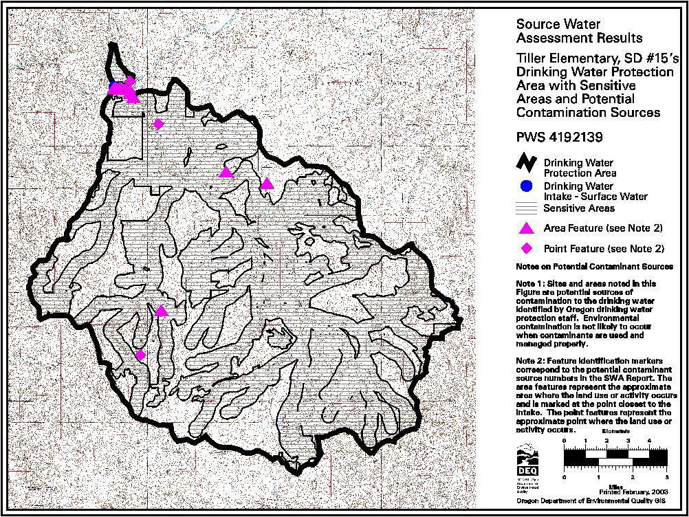
1 SOURCE WATER ASSESSMENT SUMMARY BROCHURE TILLER ELEMENTARY, SD #15 PWS # WHAT IS A SOURCE WATER ASSESSMENT? The Source Water Assessment was recently completed by the Department of Environmental Quality (DEQ) and the Oregon Department of Human Services (DHS) to identify the surface areas (and/or subsurface areas) that supply water to Tiller Elementary s public water system intake and to inventory the potential contaminant sources that may impact the water supply. WHY WAS IT COMPLETED? The Source Water Assessment was completed to provide information so that Tiller Elementary s public water system staff/operator, consumers, and community citizens can begin developing strategies to protect the source of their drinking water, and to minimize future public expenditures for drinking water treatment. The assessment was prepared under the requirements and guidelines of the Federal Safe Drinking Water Act (SDWA). WHAT AREAS ARE INCLUDED IN TILLER ELEMENTARY S DRINKING WATER PROTECTION AREA? The drinking water for Tiller Elementary, SD #15 is supplied by an intake on the South Umpqua River. This public water system serves approximately 60 citizens. The intake is located in the Elk Creek/South Umpqua River Watershed in the South Umpqua Sub-Basin of the Southern Oregon Coastal Basin. The drinking water intake for the USFS Tiller Ranger Station public water system is also located on the South Umpqua River upstream of the Tiller Elementary intake. This source water assessment addresses the geographic area providing water to Tiller Elementary s intake (Tiller Elementary s portion of the drinking water protection area) between Tiller Elementary s intake and the upstream intake for Tiller Ranger Station. Information on Tiller Elementary s protection area upstream of the Tiller Ranger Station is summarized in the assessment report. The boundaries of the Tiller Elementary s portion of the Drinking Water Protection Area are illustrated on the figure attached to this summary. In addition, there are seven drinking water intakes on the South Umpqua River downstream of Tiller Elementary s intake. Activities and impacts in the Tiller Elementary drinking water protection area have the potential to also impact downstream users. A schematic of other water providers within the South Umpqua Sub-Basin is also attached. The geographic area providing water to Tiller Elementary s intake (Tiller Elementary s portion of the drinking water protection area) extends upstream approximately 97 miles (598 stream miles including the area upstream of the Tiller Ranger Station intake) in a easterly and southerly direction and encompasses a total area of 86 square miles (537 square miles including the area upstream of the Tiller Ranger Station intake). Included in this area are a number of tributaries to the main stem, including Elk Creek and its tributaries. The protection area within an 8-hour travel time from the intake extends approximately 16 miles upstream of the Tiller Elementary intake. It is recommended that the water systems and community consider increased protection within an 8-hour travel time from the intake since eight hours should provide adequate response time to protect the integrity of the public water system intake should a spill or release occur at any crossing or discharge point to the stream. The South Umpqua River intake is located at an approximate elevation of 990 feet and the upper edge of the watershed is located at an elevation of approximately 4,900 feet at Devils Knob feet. WHAT ARE THE POTENTIAL SOURCES OF CONTAMINATION TO TILLER ELEMENTARY S PUBLIC DRINKING WATER SUPPLY? The primary intent of this inventory was to identify and locate significant potential sources of contaminants of concern. Multiple land uses including forest, residential, and commercial land uses are present in the delineated drinking water protection area. The potential contaminant sources identified in the watershed
2 include clear-cut forest lands, high road density areas, an elementary school, a rural fire department, an apartment complex, a drinking water treatment plant, a wastewater treatment plant, high density septic systems, rural homesteads, a cemetery, a repair shop, a gasoline station/market, a ranger station, mine sites, a transportation corridor and storm water outfalls. This provides a quick look at the existing potential sources of contamination that could, if improperly managed or released, impact the water quality in the watershed. WHAT ARE THE RISKS FOR OUR SYSTEM? A total of eighteen potential contaminant sources were identified in Tiller Elementary s drinking water protection area. Sixteen of these are located in the sensitive areas and twelve are high- to moderate-risk sources within sensitive areas. The sensitive areas within the Tiller Elementary drinking water protection area include areas with high soil permeability, high soil erosion potential, high runoff potential and areas within 1000 from the river/streams. The sensitive areas are those where the potential contamination sources, if present, have a greater potential to impact the water supply. The information in this assessment provides a basis for prioritizing areas in and around our community that are most vulnerable to potential impacts and can be used by the Tiller Elementary community to develop a voluntary Drinking Water Protection Plan. NEED MORE INFORMATION? Tiller Elementary s Source Water Assessment Report provides additional details on the methodology and results of this assessment. The full report is available for review at: Contact Tiller Elementary s staff if you would like additional information on these Source Water Assessment results.
3
4 1 Automobiles - Jim Lewis Welding Highway 227 Tiller Field- Within Moderate Spills, leaks, or improper handling of Repair Shops Observation sensitive automotive fluids, solvents, and repair materials during transportation, use, storage and disposal may impact the drinking water supply. 2 UST - Nonregulated Tiller Elementary Highway 227 Tiller Database (2) Within Moderate Spills, leaks, or improper handling of stored Tanks (< 1,100 School Field- sensitive materials may impact the drinking water gals or Large Observation supply. The school has a heating oil Heating Oil Tanks) tank and a large capacity septic system. Large Capacity Moderate If not properly sited, designed, installed, Septic Systems and maintained, septic systems can (serves > 20 impact drinking water. The school has a heating oil people) - Class V tank and a large capacity septic UICs system. Schools Moderate Over-application or improper handling of cleaning products, pesticides or fertilizers used on the school grounds may impact drinking water. Vehicle maintenance system. wastes may contribute contaminants. The school has a heating oil tank and a large capacity septic 3 Automobiles - Gas Tiller Market Highway 227 Tiller Database (2) Within Moderate Spills, leaks, or improper handling of fuels Stations Field- sensitive and other materials during transportation, Observation transfer, and storage may impact the drinking water supply. 4 Fire Station Tiller Rural Fire Highway 227 Tiller Field- Within Lower Spills, leaks, or improper handling of Department Observation sensitive chemicals and other materials during transportation, use, storage and disposal may impact the drinking water supply. 3/10/2003 Page 1 of 4
5 5 Apartments and USFS Apartment Tiller Ranger Station Tiller Field- Within Lower Improper use, storage, and disposal of Condominiums Complex Observation sensitive household and facility maintenance chemicals may impact the drinking water A sewer pump station pumps the waste water to the Tiller supply. Stormwater run-off or infiltration Ranger Station treatment plant. may carry contaminants to water supply. 6 Drinking Water USFS Drinking Tiller Ranger Station Tiller Field- Within Moderate Treatment chemicals and equipment Treatment Plants Water Treatment Observation sensitive maintenance materials may impact Plant groundwater or surface water source. 7 Wastewater USFS Wastewater Tiller Ranger Station Tiller Database (2) Within Higher Improper management of wastewater, Treatment Treatment Plant Field- sensitive treatment chemicals, or equipment Plants/Collection Observation maintenance materials may impact Discharge from Tiller Ranger Stations drinking water supply. Station's WWTP is just above Tiller Elementary School's 8 UST - USFS Tiller Highway 227 Tiller Database (2) Within Lower Spills or improper handling during tank Upgraded/Registere Ranger Station Field- sensitive filling or product distribution may impact d - Active Observation the drinking water supply. Risk reduced to Lower because Office Lower Spills, leaks, or improper handling of Buildings/Complexe chemicals and other materials stored and s used in maintenance or from parking areas Risk reduced to Lower because may impact the drinking water supply. UST - Nonregulated Moderate Spills, leaks, or improper handling of stored Tanks (< 1,100 materials may impact the drinking water gals or Large supply. Risk reduced to Lower because Heating Oil Tanks) UST - Confirmed Lower Existing contamination from spills, leaks, Leaking Tanks - or improper handling of stored materials DEQ List may impact the drinking water supply. Risk reduced to Lower because 3/10/2003 Page 2 of 4
6 9 Utility Stations - Substation NW of Intake Tiller Field- Just outside Higher Spills, leaks, or improper handling of Maintenance Observation DWPA chemicals and other materials including Transformer PCBs during transportation, use, storage and disposal may impact the drinking water 10 Septic Systems - High Density Town of Tiller Tiller Field- Within Moderate If not properly sited, designed, installed, High Density ( > 1 Septic Systems Observation sensitive and maintained, septic systems can system/acre) impact drinking water. Cumulative effects of multiple systems in an area may impact drinking water supply. 11 Transportation - Highway 227 Runs East-West Through Tiller Field- Within Higher Vehicle use increases the risk for leaks or Freeways/State the DWPA Observation sensitive spills of fuel & other haz. materials. Road Highways/Other building, maintenance & use can increase Directly up the bank from the Heavy Use Roads erosion/slope failure causing turbidity. intake. Also known as the Tiller Trail Highway. Over-application or improper handling of pesticides/fertilizers may impact water. 12 Mines/Gravel Pits Rowley Mine Drew Creek, South of Tiller Outside Higher Spills, leaks, or improper handling of Intake sensitive chemicals and wastes generated in mining areas. operations or from heavy equipment may Location based on a map. impact the drinking water supply. Potential risk should be verified during enhanced inventory. 13 Mines/Gravel Pits Banfield Mine Drew Creek, South of Tiller Within Higher Spills, leaks, or improper handling of Intake sensitive chemicals and wastes generated in mining operations or from heavy equipment may impact the drinking water supply. Location is based on a map. Potential risk should be verified during enhanced inventory. 14 Cemeteries - Pre- Rainville Cemetery Elk Creek, SW of Intake Tiller Within Lower Embalming fluids (for example, arsenic) 1945 sensitive and decomposition by-products may impact drinking water supply. Location is based on a map. 3/10/2003 Page 3 of 4
7 15 Managed Forest Clearcut Forest Throughout the DWPA Tiller Field- Within Higher Cutting and yarding of trees may Land - Clearcut Lands Observation sensitive contribute to increased erosion, resulting in Harvest (< 35 yrs.) turbidity and chemical changes in drinking water supply. Over-application or improper handling of pesticides or fertilizers may impact drinking water source. 16 Managed Forest High Road Throughout the DWPA Tiller Field- Within Higher Road building, maintenance, and usage Land - Road Observation sensitive may contribute to erosion and slope failure Density ( > 2 causing turbidity in drinking water supply. Vehicle usage increases the risks of leaks or spills of petroleum products and other hazardous materials. 17 Stormwater Outfalls Stormwater Along Highway 227 Tiller Field- Within Higher Stormwater run-off may contain Outfalls Observation sensitive contaminants from residential (homesites and roads), commercial/industrial, and Discharges into the Umpqua River. agricultural use areas. 18 Homesteads - Rural Rural Tiller Tiller Field- Within Lower If not properly sited, designed, installed, - Septic Systems Observation sensitive and maintained, septic systems can (< 1/acre) impact drinking water. Use of drain cleaners and dumping household hazardous wastes can result in groundwater 3/10/2003 Page 4 of 4
SOURCE WATER ASSESSMENT SUMMARY BROCHURE
 SOURCE WATER ASSESSMENT SUMMARY BROCHURE USFS TILLER RANGER STATION PWS # 4101092 WHAT IS A SOURCE WATER ASSESSMENT? The Source Water Assessment was recently completed by the Department of Environmental
SOURCE WATER ASSESSMENT SUMMARY BROCHURE
 SOURCE WATER ASSESSMENT SUMMARY BROCHURE MILL CITY WATER DEPARTMENT PWS # 4100520 WHAT IS A SOURCE WATER ASSESSMENT? The Source Water Assessment was recently completed by the Department of Environmental
SOURCE WATER ASSESSMENT SUMMARY BROCHURE
 SOURCE WATER ASSESSMENT SUMMARY BROCHURE CITY OF OAKLAND PWS # 4100581 WHAT IS A SOURCE WATER ASSESSMENT? The Source Water Assessment was recently completed by the Department of Environmental Quality (DEQ)
SOURCE WATER ASSESSMENT SUMMARY BROCHURE
 SOURCE WATER ASSESSMENT SUMMARY BROCHURE CITY OF ROSEBURG PWS # 4100720 WHAT IS A SOURCE WATER ASSESSMENT? The Source Water Assessment was recently completed by the Department of Environmental Quality
SOURCE WATER ASSESSMENT SUMMARY BROCHURE
 SOURCE WATER ASSESSMENT SUMMARY BROCHURE CITY OF ROGUE PWS # 4100712 WHAT IS A SOURCE WATER ASSESSMENT? The Source Water Assessment was recently completed by the Department of Environmental Quality (DEQ)
SOURCE WATER ASSESSMENT SUMMARY BROCHURE
 SOURCE WATER ASSESSMENT SUMMARY BROCHURE CITY OF CAVE JUNCTION PWS # 4100971 WHAT IS A SOURCE WATER ASSESSMENT? The Source Water Assessment was recently completed by the Department of Environmental Quality
SOURCE WATER ASSESSMENT SUMMARY BROCHURE
 SOURCE WATER ASSESSMENT SUMMARY BROCHURE PP&L TOKETEE VILLAGE PWS # 4101012 WHAT IS A SOURCE WATER ASSESSMENT? The Source Water Assessment was recently completed by the Department of Environmental Quality
SOURCE WATER ASSESSMENT SUMMARY BROCHURE
 SOURCE WATER ASSESSMENT SUMMARY BROCHURE USFS WOLF CREEK JOB CORPS PWS # 4101095 WHAT IS A SOURCE WATER ASSESSMENT? The Source Water Assessment was recently completed by the Department of Environmental
SOURCE WATER ASSESSMENT SUMMARY BROCHURE
 SOURCE WATER ASSESSMENT SUMMARY BROCHURE STAYTON WATER SUPPLY PWS # 4100843 WHAT IS A SOURCE WATER ASSESSMENT? The Source Water Assessment was recently completed by the Department of Environmental Quality
SOURCE WATER ASSESSMENT SUMMARY BROCHURE
 SOURCE WATER ASSESSMENT SUMMARY BROCHURE CORBETT WATER DISTRICT PWS # 4100359 WHAT IS A SOURCE WATER ASSESSMENT? The Source Water Assessment was recently completed by the Department of Environmental Quality
SOURCE WATER ASSESSMENT SUMMARY BROCHURE
 SOURCE WATER ASSESSMENT SUMMARY BROCHURE PGE BEAVER GENERATING STATION PWS # 4105246 WHAT IS A SOURCE WATER ASSESSMENT? The Source Water Assessment was recently completed by the Department of Environmental
SOURCE WATER ASSESSMENT SUMMARY BROCHURE
 SOURCE WATER ASSESSMENT SUMMARY BROCHURE WINSTON-DILLARD WATER DISTRICT PWS # 4100957 WHAT IS A SOURCE WATER ASSESSMENT? The Source Water Assessment was recently completed by the Department of Environmental
SOURCE WATER ASSESSMENT SUMMARY BROCHURE
 SOURCE WATER ASSESSMENT SUMMARY BROCHURE CITY OF AMITY PWS # 4100041 WHAT IS A SOURCE WATER ASSESSMENT? The Source Water Assessment was recently completed by the Department of Environmental Quality (DEQ)
SOURCE WATER ASSESSMENT SUMMARY BROCHURE RAINIER WATER DEPARTMENT PWS #
 SOURCE WATER ASSESSMENT SUMMARY BROCHURE RAINIER WATER DEPARTMENT PWS # 4100689 WHAT IS A SOURCE WATER ASSESSMENT? The Source Water Assessment was recently completed by the Department of Environmental
SOURCE WATER ASSESSMENT SUMMARY BROCHURE
 SOURCE WATER ASSESSMENT SUMMARY BROCHURE CITY OF ESTACADA - PWS # 4100279 WHAT IS A SOURCE WATER ASSESSMENT? The Source Water Assessment was recently completed by the Department of Environmental Quality
SOURCE WATER ASSESSMENT SUMMARY BROCHURE
 SOURCE WATER ASSESSMENT SUMMARY BROCHURE CITY OF GOLD HILL PWS # 4100333 WHAT IS A SOURCE WATER ASSESSMENT? The Source Water Assessment was recently completed by the Department of Environmental Quality
rt.= Source Water Assessment Report City of Newport, Oregon I l :( 1 PWS # October 1, 2002 Prepared for City of Newport Prepared by
 Source Water Assessment Report City of Newport, Oregon PWS #41566 October 1, 22 Prepared for City of Newport Prepared by rt.= I l :( 1 Stale of Oregon Department of Environmental Quality Water Quality
Source Water Assessment Report
 Source Water Assessment Report City of Reedsport, Oregon PWS #41699 January 9, 23 Prepared for City of Reedsport Prepared by I l :( 1 State of Oregon Department ot Environmental Quality Water Quality Division
Source Water Assessment and Protection (SWAP) Report for Northampton Water Department
 Report for Northampton Water Department") Massachusetts Department of Environmental Protection Source Water Assessment and Protection (SWAP) Report for Northampton Water Department What is SWAP? The Source Water Assessment Program (SWAP), established
Massachusetts Department of Environmental Protection Source Water Assessment and Protection (SWAP) Report for Northampton Water Department What is SWAP? The Source Water Assessment Program (SWAP), established
Dunes City Drinking Water Source Assessment and Potential Planning Strategies. Prepared by Lane Council of Governments
 Dunes City Drinking Water Source Assessment and Potential Planning Strategies Prepared by Lane Council of Governments December 2002 Dunes City Drinking Water Source Assessment and Potential Planning Strategies
Source Water Assessment Program (SWAP) Report for Rowe Elementary School
 Report for Rowe Elementary School") Source Water Assessment Program (SWAP) Report for Rowe Elementary School What is SWAP? The Source Water Assessment Program (SWAP), established under the federal Safe Drinking Water Act, requires every
Source Water Assessment Program (SWAP) Report for Rowe Elementary School What is SWAP? The Source Water Assessment Program (SWAP), established under the federal Safe Drinking Water Act, requires every
CITY OF HOYT LAKES, MINNESOTA SOURCE WATER ASSESSMENT
 CITY OF HOYT LAKES, MINNESOTA SOURCE WATER ASSESSMENT November 2002 Public Water Supplier ID 1690028 Facility Contact: Minnesota Department of Health Contact: Mr. Floyd Nelson, Supervisor Ms. Beth Kluthe
CITY OF MINNEAPOLIS SOURCE WATER ASSESSMENT
 CITY OF MINNEAPOLIS SOURCE WATER ASSESSMENT September 2001 PWS ID 1270024 City Contact: Minnesota Department of Health Contact: Mr. Adam Kramer Mr. Terry Bovee, Planner Minneapolis Public Works Source
Source Water Assessment Report
 Source Water Assessment Report City of Cave Junction, Oregon PWS #41971 March 24, 23 Prepared for City of Cave Junction Prepared by ' I l =< 1 State of Oregon Department of Environ mental Quality Water
Water Quality Regulatory Programs and Our Citywide EPA / DEQ Stormwater Permit. Public Works Engineering City Council Briefing June 7, 2016
 Water Quality Regulatory s and Our Citywide EPA / DEQ Stormwater Permit Public Works Engineering City Council Briefing June 7, 2016 Briefing Topics Introduction: Regulatory Overview Elements of the MS4
Source Water Assessment Program (SWAP) Report for Heath Elementary School
 Report for Heath Elementary School") Source Water Assessment Program (SWAP) Report for Heath Elementary School What is SWAP? The Source Water Assessment Program (SWAP), established under the federal Safe Drinking Water Act, requires every
Source Water Assessment Program (SWAP) Report for Heath Elementary School What is SWAP? The Source Water Assessment Program (SWAP), established under the federal Safe Drinking Water Act, requires every
Source Water Assessment Report
 Source Water Assessment Report PP&L Toketee Village, Oregon PWS #41112 August 3, 21 Prepared for PP&L Toketee Village Prepared by ~ ~ I l:c l Stale o1 Oregon Department of Environmental Quality Water Quality
)to HS. Source Water Assessment Report. Langlois, Oregon 111:( 1 PWS # December 12, Prepared for. Langlois Water District.
to HS. Source Water Assessment Report. Langlois, Oregon 111:( 1 PWS # December 12, Prepared for. Langlois Water District.") Source Water Assessment Report Langlois Water District Langlois, Oregon PWS #4 1 466 December 12, 22 Prepared for Langlois Water District Prepared by 111:( 1 Slate of Oregon Department of Environmental
Source Water Assessment Report Langlois Water District Langlois, Oregon PWS #4 1 466 December 12, 22 Prepared for Langlois Water District Prepared by 111:( 1 Slate of Oregon Department of Environmental
)to HS. Source Water Assessment Report. Rock Creek Water District Grand Ronde, Oregon PWS # i l :C 1. March 24, 2003
to HS. Source Water Assessment Report. Rock Creek Water District Grand Ronde, Oregon PWS # i l :C 1. March 24, 2003") Source Water Assessment Report Rock Creek Water District Grand Ronde, Oregon PWS #41337 March 24, 23 Prepared for Rock Creek Water District Prepared by ~ ~ i l :C 1 State of OrBgOn Department of Environmental
Source Water Assessment Report Rock Creek Water District Grand Ronde, Oregon PWS #41337 March 24, 23 Prepared for Rock Creek Water District Prepared by ~ ~ i l :C 1 State of OrBgOn Department of Environmental
Streamlines V2, n2 (May 1997) A Newsletter for North Carolina Water Supply Watershed Administrators
 A Newsletter for North Carolina Water Supply Watershed Administrators") Page 1 of 5 STREAMLINES A Newsletter for North Carolina Water Supply Watershed Administrators Volume 2, Number 2 May 1997 Non-Point Source (NPS) Pollution This issue of Streamlines provides basic information
Page 1 of 5 STREAMLINES A Newsletter for North Carolina Water Supply Watershed Administrators Volume 2, Number 2 May 1997 Non-Point Source (NPS) Pollution This issue of Streamlines provides basic information
Wellhead Protection Inventory Form. Table of Potential Land Use
 Wellhead Protection Inventory Form Survey Conducted by: Date: Instructions: The attached map illustrates property that is included in the approximate wellhead protection area (WHPA). The following table
6.1 Introduction to Wastewater Issues
 Section 6: Water Pollution This Section will help you: Understand if you generate industrial wastewater; Understand where your wastewater goes; Make sure you meet requirements for floor drains; Properly
SOURCE WATER ASSESSMENT SUMMARY BROCHURE
 SOURCE WATER ASSESSENT SUARY BROCURE OREGON CITY - SOUT FORK WATER BOARD, PWS #40059 NORT CACKAAS COUNTY WATER COISSION, PWS #400580 AND CACKAAS RIVER WATER, PWS #40087 WAT IS A SOURCE WATER ASSESSENT?
Source Water Assessment and Protection (SWAP) Report for Hudson Water Supply
 Report for Hudson Water Supply") Massachusetts Department of Environmental Protection Source Water Assessment and Protection (SWAP) Report for Hudson Water Supply What is SWAP? The Source Water Assessment Program (SWAP), established under
Massachusetts Department of Environmental Protection Source Water Assessment and Protection (SWAP) Report for Hudson Water Supply What is SWAP? The Source Water Assessment Program (SWAP), established under
What is a stormwater utility fee?
 What is a stormwater utility fee? A stormwater utility fee is similar to a water or sewer utility fee. In essence, customers pay a fee to convey stormwater from their properties. The City of Goodlettsville
rt.: )to HS Source Water Assessment Report City of The Dalles, Oregon PWS # i l =< 1 April 10, 2003 Prepared for City of The Dalles Prepared by
to HS Source Water Assessment Report City of The Dalles, Oregon PWS # i l =< 1 April 10, 2003 Prepared for City of The Dalles Prepared by") Source Water Assessment Report City of The Dalles, Oregon PWS #41869 April 1, 23 Prepared for City of The Dalles Prepared by rt.: i l =< 1 State of Oregon Department Qf Environmental Quality Water Quality
Source Water Assessment Report City of The Dalles, Oregon PWS #41869 April 1, 23 Prepared for City of The Dalles Prepared by rt.: i l =< 1 State of Oregon Department Qf Environmental Quality Water Quality
rt.: Source Water Assessment Report S.W. Lincoln County Water District Waldport, Oregon I 1 =< 1 Stale of Oregon Department of environmental Quality
 Source Water Assessment Report S.W. Lincoln County Water District Waldport, Oregon PWS #41925 August 17, 21 Prepared for S.W. Liucoln County Water District Prepared by rt.: ~ I 1 =< 1 Stale of Oregon Department
Our Eastern Shore Groundwater Part IV Groundwater Quality on the Eastern Shore: How safe is our groundwater and are there ways we can protect it?
 Our Eastern Shore Groundwater Part IV Groundwater Quality on the Eastern Shore: How safe is our groundwater and are there ways we can protect it? Britt McMillan, Malcolm Pirnie, Inc. Mercury Venus Mars
LIVINGSTON COUNTY DRAIN COMMISSIONER Brian Jonckheere
 MICHIGAN DEPARTMENT OF ENVIRONMENTAL QUALITY GENERAL STORM WATER PERMIT MIG619000 ILLICIT DISCHARGE ELIMINATION PLAN FOR LIVINGSTON COUNTY DRAIN COMMISSIONER Brian Jonckheere Table of Contents Section
Source Water Assessment and Protection (SWAP) Report for Wrentham Water Division
 Report for Wrentham Water Division") Massachusetts Department of Environmental Protection Source Water Assessment and Protection (SWAP) Report for Wrentham Water Division What is SWAP? The Source Water Assessment and Protection (SWAP) program,
Massachusetts Department of Environmental Protection Source Water Assessment and Protection (SWAP) Report for Wrentham Water Division What is SWAP? The Source Water Assessment and Protection (SWAP) program,
City of Evanston STORMWATER MANAGEMENT PLAN February 2018
 City of Evanston STORMWATER MANAGEMENT PLAN February 2018 1 1.0 Table of Contents 2.0 INTRODUCTION...3 2.1 SMP STRUCTURE... 3 2.2 AREA SUBJECT TO THE PLAN... 3 2.3 SMP DEVELOPMENT... 3 2.4 ANNUAL REPORTING...
Septic Systems. A Complete Guide To Understanding How They Work and How To Keep Them Healthy
 Septic Systems A Complete Guide To Understanding How They Work and How To Keep Them Healthy What Is A Septic System? Wastewater from a home, which includes the water from toilets, laundry, showers, sinks
Source Water Assessment and Protection (SWAP) Report for Three Rivers Fire District
 Report for Three Rivers Fire District") Massachusetts Department of Environmental Protection Source Water Assessment and Protection (SWAP) Report for Three Rivers Fire District What is SWAP? The Source Water Assessment Protection (SWAP) program,
Massachusetts Department of Environmental Protection Source Water Assessment and Protection (SWAP) Report for Three Rivers Fire District What is SWAP? The Source Water Assessment Protection (SWAP) program,
rl: Source Water Assessment Report Rhododendron Summer Homes Association, Oregon PWS # I l :( 1 April 8, 2003
 Source Water Assessment Report 1: Rhododendron Summer Homes Association, Oregon PWS #4100702 April 8, 2003 Prepared for Rhododendron Sunnner Homes Association Prepared by ~ rl: I l :( 1 State ot Oregon
CITY OF ST. PAUL SOURCE WATER ASSESSMENT
 CITY OF ST. PAUL SOURCE WATER ASSESSMENT September 2001 PWS ID 1620026 City Contact: Mr. David Schuler St. Paul Regional Water Services 8 Fourth Street East St. Paul, Minnesota 55101 Telephone Number:
Grand Traverse Bay Watershed Protection Plan:
 Grand Traverse Bay Watershed Protection Plan: An Overview Sarah U Ren Program Director The Watershed Center 231-935-1514, suren@gtbay.org What is a Watershed? A watershed is an area of land that captures
CHAPTER 5. NPDES PHASE II EVALUATION
 CHAPTER 5. NPDES PHASE II EVALUATION A Stormwater Management Program for Medford was developed and submitted to the DEQ to meet requirements of the NPDES Phase II program. Phase II regulations require
SOURCE WATER PROTECTION PLANNING
 SOURCE WATER PROTECTION PLANNING MOVING FROM ASSESSMENT TO ACTION Amy Williams Source Water Program Coordinator Department of Environmental Quality Jerry Mason Attorney Mason & Stricklin, LLP Who is DEQ?
Part 2. SOURCE WATER PROTECTION: Developing a Plan that Works for YOU
 Part 2 SOURCE WATER PROTECTION: Developing a Plan that Works for YOU Mark Stephens, P.G. PA DEP North Central Region Office Williamsport m.stephens@state.pa.us SWP Quick Review What Is Source Water Protection?
The Lake Maumelle watershed
 Source Water Protection Central Arkansas: Programs & Practices Martin Maner, PE and Trevor Clements Implementing Adaptive Management in Central Arkansas Introduction The Lake Maumelle watershed in central
DC STORMWATER PLAN CONSOLIDATED TOTAL MAXIMUM DAILY LOAD (TDML) IMPLEMENTATION PLAN
 IMPLEMENTATION PLAN") DC STORMWATER PLAN CONSOLIDATED TOTAL MAXIMUM DAILY LOAD (TDML) IMPLEMENTATION PLAN CONTENTS Introduction 1 The Challenge 5 The Solution 7 Tracking Progress 11 What can you do? 15 INTRODUCTION The DC Stormwater
DC STORMWATER PLAN CONSOLIDATED TOTAL MAXIMUM DAILY LOAD (TDML) IMPLEMENTATION PLAN CONTENTS Introduction 1 The Challenge 5 The Solution 7 Tracking Progress 11 What can you do? 15 INTRODUCTION The DC Stormwater
Non-point source pollution now accounts for over 75% of Pennsylvania s total water pollution
 2. Non-point Source Pollution Living on the Landscape and How We Affect Our Shared Water Resources by John Jose, Watershed Specialist, Pike County Conservation District Water is the most critical resource
TITLE 252. DEPARTMENT OF ENVIRONMENTAL QUALITY CHAPTER 616. INDUSTRIAL WASTEWATER SYSTEMS SUBCHAPTER 1. INTRODUCTION [AMENDED]
![TITLE 252. DEPARTMENT OF ENVIRONMENTAL QUALITY CHAPTER 616. INDUSTRIAL WASTEWATER SYSTEMS SUBCHAPTER 1. INTRODUCTION [AMENDED]](/thumbs/90/103047993.jpg "TITLE 252. DEPARTMENT OF ENVIRONMENTAL QUALITY CHAPTER 616. INDUSTRIAL WASTEWATER SYSTEMS SUBCHAPTER 1. INTRODUCTION [AMENDED]") TITLE 252. DEPARTMENT OF ENVIRONMENTAL QUALITY CHAPTER 616. INDUSTRIAL WASTEWATER SYSTEMS SUBCHAPTER 1. INTRODUCTION [AMENDED] 252:616-1-1. Purpose 252:616-1-2. Definitions [AMENDED] 252:616-1-2. Definitions
TITLE 252. DEPARTMENT OF ENVIRONMENTAL QUALITY CHAPTER 616. INDUSTRIAL WASTEWATER SYSTEMS SUBCHAPTER 1. INTRODUCTION [AMENDED] 252:616-1-1. Purpose 252:616-1-2. Definitions [AMENDED] 252:616-1-2. Definitions
City of Valdosta Land Development Regulations
 Chapter 324 Section 324-1 Environmental Planning Criteria Protection of Groundwater Recharge Areas (A) Purpose and Intent. Pursuant to O.C.G.A. 12-2-8 and the Georgia Department of Natural Resources (DNR),
Source Water Assessment and Protection (SWAP) Report for Bellingham DPW Water & Sewer Division
 Report for Bellingham DPW Water & Sewer Division") Massachusetts Department of Environmental Protection Source Water Assessment and Protection (SWAP) Report for Bellingham DPW Water & Sewer Division What is SWAP? The Source Water Assessment Protection
Massachusetts Department of Environmental Protection Source Water Assessment and Protection (SWAP) Report for Bellingham DPW Water & Sewer Division What is SWAP? The Source Water Assessment Protection
OF CONTENTS 14.0 COUNTY OF BRANT...
 TABLE OF CONTENTS 14.0 COUNTY OF BRANT... 14-1 14.1 Definitions... 14-1 14.2 County Of Brant Source Protection Plan Policies... 14-2 14.3 Policies Addressing Prescribed Drinking Water Threats... 14-6 14.4
Part 2.0 Non-Numeric Effluent Limitations
 2017 NH Small MS4 General Permit Page 50 of 67 report on its findings and progress towards making the practices allowable. (Information available at: http://www.epa.gov/region1/npdes/stormwater/assets/pdfs/addressingbarrier2lid.pdf
Welcome The purpose of this information is to give you an opportunity to:
 Welcome The purpose of this information is to give you an opportunity to: Learn how the Ada County Highway District (ACHD) is meeting requirements and milestones in our Phase II Stormwater Management Plan,
rl: Source Water Assessment Report PGE Beaver Generating Station, Oregon It] X l PWS # December 14, 2000
![rl: Source Water Assessment Report PGE Beaver Generating Station, Oregon It] X l PWS # December 14, 2000](/thumbs/72/67496719.jpg "rl: Source Water Assessment Report PGE Beaver Generating Station, Oregon It] X l PWS # December 14, 2000") Source Water Assessment Report PGE Beaver Generating Station, Oregon PWS #45246 December 4, 2 Prepared for PGE Beaver Generating Station Prepared by ~ rl: It] X l State of Oregon Department ot Environmental
Source Water Assessment Report PGE Beaver Generating Station, Oregon PWS #45246 December 4, 2 Prepared for PGE Beaver Generating Station Prepared by ~ rl: It] X l State of Oregon Department ot Environmental
The Village of Wellington NPDES Guidance/Reference Document
 The Village of Wellington NPDES Guidance/Reference Document The following Permit Compliance Guidance/Reference Document has been compiled to assist the copermittee in fulfilling the requirements of the
Vancouver Watershed Health Assessment. Burnt Bridge Creek Watershed
 Vancouver Watershed Health Assessment Burnt Bridge Creek Watershed Presentation Overview 1. Introduction 2. Study Context 3. Burnt Bridge Creek Monitoring Program and Trend Analysis 4. Watershed Health
Wellhead Protection Issues Related to Mining Activities Minnesota Rural Water Conference March 4, 2014
 Wellhead Protection Issues Related to Mining Activities Minnesota Rural Water Conference March 4, 2014 Terry Bovee Source Water Protection Unit Minnesota Department of Health Purpose Response to requests
The effects of pollution. What is stormwater runoff? Why is stormwater runoff a problem?
 What is stormwater runoff? Stormwater runoff occurs when precipitation from rain or snowmelt flows over the ground. Impervious surfaces like driveways, sidewalks, and streets prevent stormwater from naturally
APPROVED SOURCE PROTECTION PLAN: CTC Source Protection Region
 7 PRESCRIBED THREATS A drinking water threat is defined in the Clean Water Act, 2006 (Section 2(1)) as: an activity or condition that adversely affects or has the potential to adversely affect the quality
rt.: Source Water Assessment Report Colton Water District Colton, Oregon PWS # I l =< 1 Sta!e of Oregon Department of Environmental Quality
 Source Water Assessment Report Colton Water District Colton, Oregon PWS #4122 December 4, 22 Prepared for Colton Water District Prepared by rt.: ~ l =< 1 Sta!e of Oregon Department of Environmental Quality
You are the solution to water pollution. A guide for preventing water pollution in your own backyard
 You are the solution to water pollution A guide for preventing water pollution in your own backyard Even if you live miles away from a river or stream, you may be polluting the water without even knowing
Source Water Assessment and Protection (SWAP) Report for Hinsdale Water Department
 Report for Hinsdale Water Department") Massachusetts Department of Environmental Protection Source Water Assessment and Protection (SWAP) Report for Hinsdale Water Department What is SWAP? The Source Water Assessment Program (SWAP), established
Massachusetts Department of Environmental Protection Source Water Assessment and Protection (SWAP) Report for Hinsdale Water Department What is SWAP? The Source Water Assessment Program (SWAP), established
Agricultural/Rural Riparian Buffer Analysis
 Agricultural/Rural Riparian Buffer Analysis December 2014 Executive Summary The Agricultural/Rural Riparian Buffer Analysis was developed from a 2014 analysis of current requirements for the riparian areas
2. DEFINITIONS. American Association of State Highway and Transportation Officials.
 2. DEFINITIONS 2.010 Definitions [See Amendment 2] In addition to words and terms that may be defined elsewhere in this manual, the following words and terms shall have the meanings defined below: AASHTO:
How does groundwater get in the earth? Where does it come from?
 What is Groundwater? How does groundwater get in the earth? Where does it come from? Groundwater begins as rain or snow that falls to the ground. This is called precipitation. Only a small portion of this
S5.C.1 Public Education and Outreach
 City of Ferndale 2018 Stormwater Management Program This document is formatted as a response to specific special conditions within the Western Washington Phase II Municipal Stormwater Permit (Permit) that
City of Guelph Transfer of Review Procedures 7 March, 2017
 Step 1-Determine where the project is located on the City of Guelph Vulnerability Map If the project is found not to be located in a vulnerability area with a vulnerability score of 8 or higher (See Attachment
Protect Your Community s Drinking Water Supply While Managing Stormwater in Your Community
 Protect Your Community s Drinking Water Supply While Managing Stormwater in Your Community Stormwater impacts drinking water what can you do about it? State and Federal requirements protect supplies from
Additional Information Requirements for Wastewater Treatment Projects
 Version 04-11-25 Page 1 of 6 Additional Information Requirements for Wastewater Treatment Projects Pursuant to Section 5(2) of the Environmental Impact Assessment Regulation of the Clean Environment Act,
SCOPE OF WORK (Last amendment 9/18/08) Update: Signed agreement in hand Work to proceed March 15, 2009 June 30, 2010
 Update: Signed agreement in hand Work to proceed March 15, 2009 June 30, 2010") SCOPE OF WORK (Last amendment 9/18/08) Update: Signed agreement in hand Work to proceed March 15, 2009 June 30, 2010 TITLE: IDENTIFICATION OF ILLICIT DISCHARGES TO STORM DRAIN SYSTEM PROBLEM/NEED: The
SCOPE OF WORK (Last amendment 9/18/08) Update: Signed agreement in hand Work to proceed March 15, 2009 June 30, 2010 TITLE: IDENTIFICATION OF ILLICIT DISCHARGES TO STORM DRAIN SYSTEM PROBLEM/NEED: The
SOURCE WATER ASSESSMENT PROJECT:
 SOURCE WATER ASSESSMENT PROJECT: An Assessment of Potential for Pollution of Surface Drinking Water Supply Sources Prepared by the Atlanta Regional Commission for Cherokee County Water & Sewer Authority
Model Riparian Buffer Ordinance.
 Model Riparian Buffer Ordinance. This is a sample riparian buffer ordinance written as an amendment to an existing zoning ordinance. This ordinance complies with the state minimum standards for river corridor
From My Backyard to Our Bay It s the 911 for the Chesapeake Bay
 From My Backyard to Our Bay Reporting Problems on Our Bay, Rivers, and Streams We can all be the eyes and ears of our local waterways. Maryland has established the Chesapeake Bay Safety and Environmental
STORMWATER MANAGEMENT PLAN CONTENTS CHECKLIST Stormwater Management Plan Contents. SWMP Page # or Reference Location Yes/No
 STORMWATER MANAGEMENT PLAN CONTENTS CHECKLIST Stormwater Management Plan Contents Site Description A description of construction activity. The proposed sequence for major activities. Estimates of the total
Source Water Assessment and Protection (SWAP) Report for Acton Water Supply District
 Report for Acton Water Supply District") Massachusetts Department of Environmental Protection Source Water Assessment and Protection (SWAP) Report for Acton Water Supply District What is SWAP? The Source Water Assessment and Protection (SWAP)
Massachusetts Department of Environmental Protection Source Water Assessment and Protection (SWAP) Report for Acton Water Supply District What is SWAP? The Source Water Assessment and Protection (SWAP)
Drinking Water Source Protection General Information on Funding and Rating Projects
 Drinking Water Source Protection General Information on Funding and Rating Projects The FFY-2014 Funding Drinking Water Source Protection (DWSP) Letter of Interest (LOI) solicitation will be used to gather
Guidance on each of the 23 basic elements follows: Plan Index showing locations of required items: The plan index should include a list of the
 Guidance on each of the 23 basic elements follows: A1 Plan Index showing locations of required items: The plan index should include a list of the required items in the rule and where they occur in the
CITY OF HAPEVILLE STORMWATER UTILITY IMPLEMENTATION. Presented by: Michael J. Moffitt, P.E. (Keck & Wood, Inc.) City Engineer.
 City Engineer.") CITY OF HAPEVILLE STORMWATER UTILITY IMPLEMENTATION Presented by: Michael J Moffitt, PE (Keck & Wood, Inc) City Engineer May, 2016 What is Stormwater? Stormwater is rain or snowmelt that falls on streets,
CITY OF HAPEVILLE STORMWATER UTILITY IMPLEMENTATION Presented by: Michael J Moffitt, PE (Keck & Wood, Inc) City Engineer May, 2016 What is Stormwater? Stormwater is rain or snowmelt that falls on streets,
Stormwater Management Program
 Stormwater Management Program Revised March 2012 For Use In NPDES Phase II Implementation for Secondary Permittees. Stormwater Management Program Table of Contents Introduction... 3 CDID #1 Background...
Guidance Document for Storm Water Pollution Prevention Plan (SWPPP) Submittal. A2 Plat showing building lot numbers/boundaries and road layout/names:
 Submittal. A2 Plat showing building lot numbers/boundaries and road layout/names:") Exhibit SW12-3 Page 1 of 10 Guidance Document for Storm Water Pollution Prevention Plan SECTION A CONSTRUCTION PLAN ELEMENTS A1 Plan Index showing locations of required items: The plan index should include
Exhibit SW12-3 Page 1 of 10 Guidance Document for Storm Water Pollution Prevention Plan SECTION A CONSTRUCTION PLAN ELEMENTS A1 Plan Index showing locations of required items: The plan index should include
By Paul Robinson Research Director Southwest Research and Information Center PO Box 4524 Albuquerque, NM
 Fact Sheet Concerning Sources of Groundwater Contamination at the Technical Area Five (TA-V), the Tijeras Arroyo Groundwater (TAG) and the Burn Site Areas of Concern at Sandia National Laboratories By
The Orange County Stormwater Program
 The Orange County Stormwater Program 1 Water Resources are Crucial to Orange County Water provides recreation for Orange County residents. It attracts tourists, boosting the local economy. It is home to
Why should you be concerned?
 Farm & Home Water Quality Assessment Protecting Your Water Quality Through a Farm & Home Assessment Why should you be concerned? About 95 percent of the families who live in the country get water from
Nonpoint Source Pollution A Challenge to Control
 Nonpoint Source Pollution A Challenge to Control Connecticut Envirothon Aquatics Workshop January 14, 2017 Presented by Denise Savageau Conservation Director, Town of Greenwich Point Source Pollution is
DEKALB COUNTY STORMWATER MANAGEMENT PLAN PHASE 2
 DEKALB COUNTY STORMWATER MANAGEMENT PLAN PHASE 2 Introduction DeKalb County, Illinois, located approximately 50 miles west of Lake Michigan, is rectangular in shape, with a north/south dimension of 36
Summary of Basin Characteristics and Facilities. General Land-use Characteristics: Withdrawal and Discharge Sites: Sampling Site Statistics:
 This report was prepared by the Kentucky Water Research Institute as a product of the statewide Kentucky Watershed Management process. Information presented in this report was collected from many sources.
Federal Storm Water Requirements
 Federal Storm Water Requirements Potomac Drinking Water Source Water Protection Partnership June 1, 2006 Presented by: Paula Estornell, USEPA Region III Overview of Federal Storm Water Requirements Introduction
Storm Water Permitting Requirements for Construction Activities. John Mathews Storm Water Program Manager Division of Surface Water
 Storm Water Permitting Requirements for Construction Activities John Mathews Storm Water Program Manager Division of Surface Water Why Permit Storm Water? Impacts During Construction Not an issue until
Municipal Stormwater Management Plan Prepared For The Borough of Cape May Point By Van Note-Harvey Associates VNH File No.
 Municipal Stormwater Management Plan Prepared For The Borough of Cape May Point By Van Note-Harvey Associates 2005 VNH File No. 35317-210-21 Table of Contents Introduction... 3 Goals... 3 Storm water Discussion...
Cannon River One Watershed, One Plan. POLICY COMMITTEE MEETING January 10, 2018 Rice County Government Center Faribault, MN
 Cannon River One, One Plan POLICY COMMITTEE MEETING January 10, 2018 Rice County Government Center Faribault, MN TASK Task 1. Aggregate Existing Physical & Spatial Data 1A. Create project maps 1B. Meeting
Contractors, Illicit Discharges, & Best Management Practices. Chris Allen Stormwater Inspector
 Contractors, Illicit Discharges, & Best Management Practices Chris Allen Stormwater Inspector What is an Illicit Discharge? Georgetown County Stormwater Ordinance defines an Illicit Discharge as: Any activity
FORM 4340 ENVIRONMENTAL QUESTIONNAIRE
 FORM 4340 ENVIRONMENTAL QUESTIONNAIRE ENVIRONMENTAL QUESTIONNAIRE Persons to be Questioned The following questions should be asked of the current owner of the property any commercial occupant of the property
Surface Water Management
 Surface Water Management Figure 7: Examples of Nonpoint Source Pollution The water quality leaving the metropolitan area is as good as the water quality entering the metropolitan area, and in compliance
City of Richmond Municipal Separate Storm Sewer System Annual Report
 City of Richmond Municipal Separate Storm Sewer System 2016-2017 Annual Report Introduction This annual report covers the reporting cycle July 1, 2016 through June 30, 2017 - Permit Year 4. The report
COON CREEK WATERSHED DISTRICT PERMIT REVIEW. KTJ 314, LLC Blaine, MN 55449
 18-118 ABRA Auto Body, Page 1 of 8 COON CREEK WATERSHED DISTRICT PERMIT REVIEW MEETING DATE: August 13, 2018 AGENDA NUMBER: 14 FILE NUMBER: 18-118 ITEM: ABRA Auto Body RECOMMENDATION: Approve with 6 Stipulations