Water Education Foundation Briefing Water Year 2016: San Joaquin Valley Groundwater Conditions
|
|
|
- Helen Carroll
- 6 years ago
- Views:
Transcription

1 Groundwater in Fractured Rock Aquifers Well Location, Yield, and Sustainability Water Education Foundation Briefing Water Year 2016: San Joaquin Valley Groundwater Conditions John Kirk, PG, CEG, CHG Engineering Geologist Division of Integrated Regional Water Management South Central Region Office
2 Burning Questions What is a fractured rock aquifer? How does it differ from an alluvial aquifer? How much water is stored in fractures? What are typical well yields? Is pumping sustainable? What about groundwater quality?
3 What is a Fractured Rock Aquifer?
 An alluvial aquifer stores and transports")

4 There are two main types of aquifers: alluvial and fractured rock. The primary distinction: (Alluvial Aquifer) An alluvial aquifer stores and transports water through sediment pores A *fractured rock aquifer has limited storage capability and transports water along planar breaks. *aka bedrock, crystalline rock, hard rock, basement. (Water Bearing Fractured Rock)

5 Porosity Primary Porosity Secondary Porosity

6 Alluvial Aquifers Unconsolidated sediment Underlies valley floors & coastal plains

7 California s Groundwater Basins Alluvial aquifers Fractured rock need not apply 515 alluvial basins/subbasins Source: DWR s Bulletin 118, update 2003
8

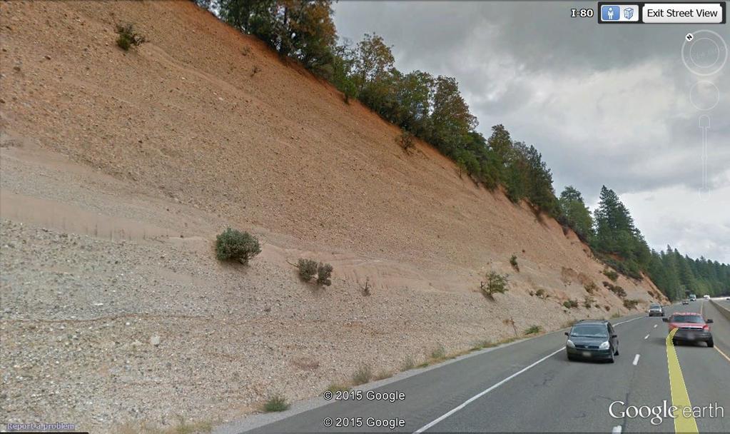
9 Fractured rock aquifer Another exhumation


10 Where are Fractured Rock Aquifers? Source: DWR s Bulletin 118, update 2003

11 Regular fracture pattern, closely spaced cracks with large openings. Drill here!

12 Very nice fractured rock Aquifer potential

13 Not All Rock is Fractured and Water Bearing Imagine this covered with soil with no clues as to where to drill. Solid, unbroken granite. Almost no chance for a well.
14 Hints to an aquifer s location.

15 Hints to an aquifer s location.
16 What is the Relationship between Fractures and Well Production? Fractures are the main or only way groundwater is stored and transmitted. How much water a well produces depends on: Size and depth of fracture opening Fracture spacing Interconnection of fractures A source of recharge Source: DWR Water Facts 1.
17 Fractured Rock Aquifers Storage & Permeability Depends on Secondary Porosity Fracture Characteristics Unfavorable Favorable -Size and Depth - Spacing - Interconnection
18 How Much Water is Stored in Fractures? 1 cubic foot of: unconsolidated alluvial sediment with a porosity of 15%-50% contains: 1.4 to 3.7 gallons of water impermeable rock with a fracture 1 mm in width contains: 0.03 gallons of water
19 Source: DWR Water Facts 1. Groundwater stored in a fractured rock aquifer is much less than 2% of the rock volume.
20 Well Yield
21 How will you know if you ll get a high production well? You won t. Half of all hard rock wells yield 0 to 10 gpm. Depending on the area, 10% or more of the wells drilled could be dry. Wide range in well production: dry to several hundred gpm.
22 Well Yields in Fractured Rock Aquifers Higher Yields Gentle slopes Swales or valley bottoms W/in 100 feet of lineament Near surface water Fractures on major trends Large drainage area Commercial well Lower Yields Steep slopes Hilltops No lineaments No surface water No fracture trend Small drainages Shallow, private well Source: USGS Prof. Paper 1660, Factors Related to Well Yield in the Fractured-Bedrock Aquifer of New Hampshire.
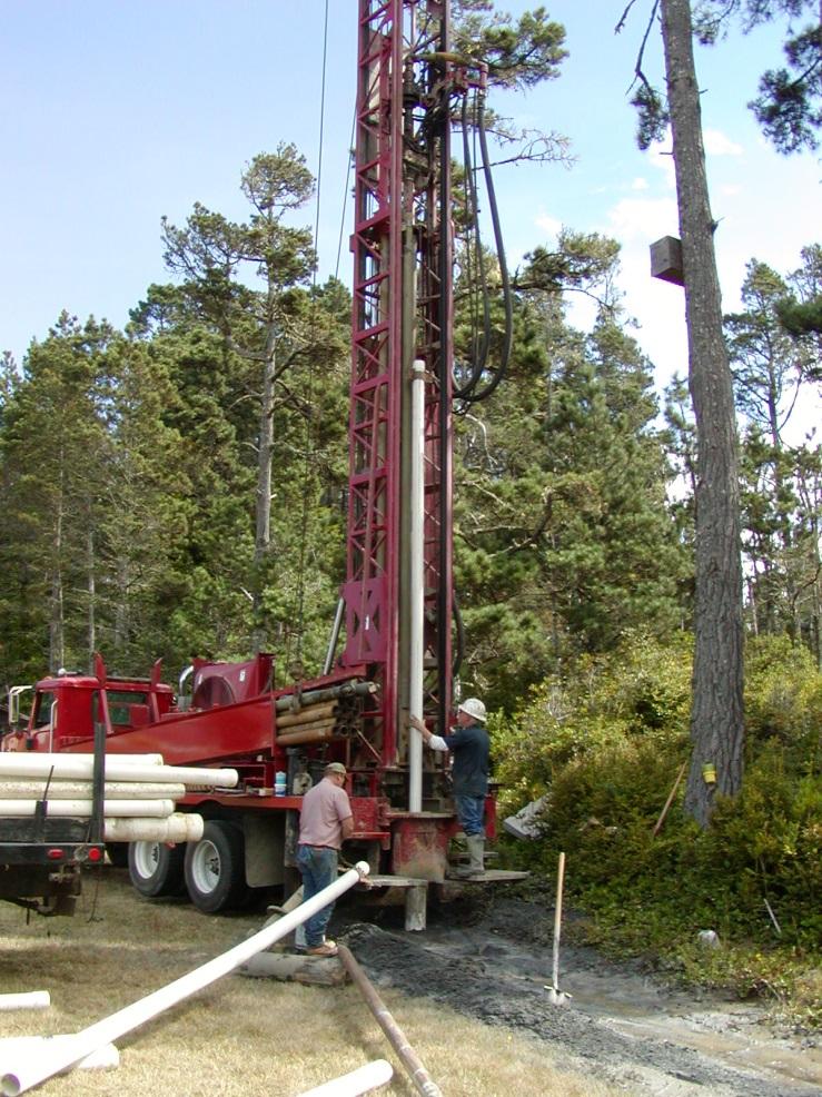
23 Require Specialized Drilling Equipment

24 *Well Yields in the Three Rivers Area *Well yields were estimated by air lift at the time of drilling. These are only rough estimates of the wells long-term pumping capacity. A rule of thumb to estimate in-use pumping capacity is 1/4 to 1/2 of the air lift test.
25 Dry Wells There is no requirement to report a dry well and little is known about their occurrence. Anecdotal information comes from visits to DWR by worried homeowners with dry wells. There have been areas where individual homesites and/or groups of homes have dry wells with failed repeated attempts to re-drill. Shallow wells or wells with only shallow fractures dry up first.

26 DRY WELLS REPORTED TO TULARE COUNTY
27 How Deep Should I Drill?
28 Common practice concludes that fracture size and interconnection decrease with depth. A USGS Nevada County study concluded that most fractures occur above 215 feet. Below this depth there is an abrupt decrease in well yield. A USGS study Optimum Depth of Wells in Crystalline Rocks concluded wells should be less than 150 to 250 feet and commercial wells less than 600 feet. A Shaver Lake study found most wells were above a depth of 180 feet with yields of 3 to 17 gpm.
29 Well Depths in the Three Rivers Area
30 On the Other Hand Deep fractures may provide higher yielding wells. Examples: Fishcamp resort development with 5 wells 1,000 feet deep all producing 50 to more than 100 gpm Millerton Lake land development where a single fracture at 970 produced >100 gpm. Coarsegold residential development with higher yields.
31 Coarsegold Area Development Well Depth (feet) 1,600 1,400 1,200 1, Well Yield (gpm)
32 Should I stay or should I go? This raises the question: If while drilling, few waterbearing fractures are encountered, should I 1. stop drilling at my current depth and find a 2 nd drill site, or 2. continue drilling to greater depths? Answer: seek advice from experienced professionals.
33 How Much Water Do I Need from My Well?
.")
34 WATER DEMAND FOR AN INDIVIDUAL HOUSEHOLD Annual Water Use US EPA estimate: 300 gallons/day California single-family estimate: 360 gallons/day. Foothill community near Coarsegold: 310 gallons/day average (from water meters so includes all water use). County building/health departments commonly require more for minimum well capacity.
 Summer: 480 gallons/day (0.")
35 But, Water Demand Varies Greatly by Season Winter: 195 gallons/day (0.15 gpm continuous pumping) Summer: 480 gallons/day (0.35 gpm continuous pumping) Annual use: 110,000 gallons per home (0.34 acre-feet).
36 How Sustainable is Pumping?
37 Two Methods Used Water balance (Three Rivers area) Groundwater hydrographs (Coarsegold area)
38 Water Balance Example from Three Rivers Kaweah River Watershed
39 Where are Fractured Rock Aquifers? Kaweah River Watershed Study Area Source: DWR s Bulletin 118, update 2003

40 LOCATION Kaweah River Watershed Local Watersheds
 being less than 10 acres in")
41 WATERSHEDS AND RESIDENTIAL LOTS OF THE THREE RIVERS AREA There are 1,575 parcels within the watersheds with 1,194 (81%) being less than 10 acres in size.
42 GROUNDWATER RECHARGE METHODOLOGY An older method that can be used to broadly estimate groundwater recharge. Although the method has limitations, it can provide a simple and quick generalized estimate of regional recharge.
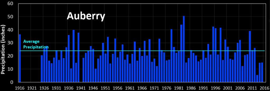
43 Groundwater Recharge for Mountain Basins Estimated from: Amount of precipitation Evapotranspiration (vegetation cover, temperature and elevation effects) Physiography Elevation Geology Runoff Climate

44 Groundwater Recharge Estimation About 15 inches, almost 40%, infiltrates into the subsurface and recharges the groundwater. For a watershed receiving 38. Less than 2 inches, or about 10%, recharges the groundwater. And the range of values is 0 to 5 inches. But a watershed receiving 18 of rain
45 Is Water Use and Water Supply in Balance?


46 WATER BALANCE Average Precipitation Across the Kaweah River Watershed = 22.5 inches. Estimated groundwater recharge = 4 inches. Groundwater Recharge Groundwater Use 27,500 AF 318 AF

47 Is Water Use and Water Supply in Balance? Overall, yes. But not for all. Estimate is based on average precipitation. A dry year or consecutive years of drought will severely constrain the estimate. Estimate is for the entire watershed. Lower, river floor areas will be more sustainable than view lots. Well Locations
48 Sustainability Estimated from Groundwater Hydrographs Example from Coarsegold Area

49 Where are Fractured Rock Aquifers? Coarsegold Study Area Kaweah River Basin Study Area Source: DWR s Bulletin 118, update 2003

50 Example from Coarsegold Area Madera Millerton Lake Fresno

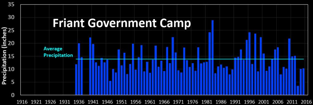
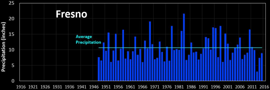
51 Precipitation

52 Sustainability Evaluated by Hydrographs Coarsegold Area Example Public Water Supply Well Locations Millerton Lake
53 Sustainability Evaluated by Hydrographs
54 Sustainability Evaluated by Hydrographs
55 Sustainability Evaluated by Hydrographs
56 What About Groundwater Quality?
57 Typically very good quality with low mineral content in a properly constructed well. Common problem constituents: Silica Iron and manganese Some areas contain naturally occurring radioactive materials: uranium, radon, and gross alpha. Some areas contain naturally occurring saline water, H 2 S and/or thermal groundwater commonly associated with the Foothills Lineament.

58 Groundwater Quality Issues and the Foothill Lineament

59 The Foothill Lineament Salt, Thermal Water, and Hydrogen Sulfide References: Seymour Mack and Dana Le Tourneau, Saline Water in Granitic Rocks of the Western Sierra Nevada Foothills, Western Foothills Research Institute. Three Rivers Water Supply Study, DWR.
60 Burning Questions What is a fractured rock aquifer? How does it differ from an alluvial aquifer? How much water is stored in fractures? What are typical well yields? Is pumping sustainable? What about groundwater quality?

61 Questions? Credit: Despair.com John Kirk, PG, CEG, CHG Engineering Geologist Division of Integrated Regional Water Management South Central Region Office
Regional Water Study of the Foothill and Mountain Areas of Eastern Fresno County
 Regional Water Study of the Foothill and Mountain Areas of Eastern Fresno County Prepared for: Fresno County Department of Public Works and Planning 2220 Tulare Street, Courtyard Level Fresno, California
General Groundwater Concepts
 General Groundwater Concepts Hydrologic Cycle All water on the surface of the earth and underground are part of the hydrologic cycle (Figure 1), driven by natural processes that constantly transform water
MEMORANDUM. FROM: Jordan Kear, P.G., C.Hg. KG
 MEMORANDUM TO: Mr. Robert Elliott Little Baldy Water Company PO Box 313 Llano, California 93544 FROM: Jordan Kear, P.G., C.Hg. KG12-0100 DATE: July 20, 2012 SUBJECT: Reconnaissance Level Hydrogeologic
Ground Water, Wells and the Summer of 1999
 Maine Geologic Facts and Localities October, 1999 Ground Water, Wells and the Summer of 1999 Text by Marc C. Loiselle, Department of Agriculture, Conservation & Forestry 1 Introduction The summer of 1999
Groundwater in the Santa Rosa Plain
 . Groundwater in the Santa Rosa Plain Marcus Trotta, PG, CHg Principal Hydrogeologist Sonoma County Water Agency Santa Rosa Plain Groundwater Sustainability Agency October 12, 2017 www.sonomacountywater.org
Albemarle County Hydrogeologic Assessment Summary Report
 Albemarle County Hydrogeologic Assessment Summary Report Phase II Groundwater Availability and Sensitivity Assessment with Proposed Groundwater Assessment Standards Presented To: County of Albemarle Department
Overview of Conjunctive Management in California Let s Have a Frank Discussion
 Overview of Conjunctive Management in California Let s Have a Frank Discussion Mark S. Nordberg, P.G. Division of Integrated Regional Water Management North Central Region Office Geology and Groundwater
SALINAS VALLEY GROUNDWATER BASIN SETTING INITIAL REVIEW FOR DEVELOPMENT OF GROUNDWATER SUSTAINABILITY PLAN
 1 SALINAS VALLEY GROUNDWATER BASIN SETTING INITIAL REVIEW FOR DEVELOPMENT OF GROUNDWATER SUSTAINABILITY PLAN May 10, 2018 Prepared for Salinas Valley Basin Groundwater Sustainability Agency Outline Purpose
Why Care About Contaminants in Groundwater?
 Why Care About Contaminants in Groundwater? Subject/ target grade: Middle School (8 th grade) Earth Science Duration: Two 50 minute periods Setting: Classroom Materials and Equipment Needed: Per class
groundwater. Because watersheds are complex systems, each tends to respond differently to natural or human activities.
 The private development of Altos del María is located at an altitude between 550 and 1,000 meters above sea level in the environmentally sensitive Cordillera Central of Panama that separates the Pacific
Groundwater and Groundwater Surface Water Interaction: How Does It Work?
 Napa Valley Groundwater Advisory Committee February 23, 2012 Groundwater and Groundwater Surface Water Interaction: How Does It Work? Thomas Harter University of California, Davis ThHarter@ucdavis.edu
Groundwater and surface water: a single resource. Santa Cruz River, Tucson
 Groundwater and surface water: a single resource Santa Cruz River, Tucson 1942 1989 1 Groundwater basics Groundwater is water found within the pore spaces of geologic material beneath the surface of the
State of the Valley Report
 State of the Valley Report An overview of the characteristics and trends of natural resources in the San Joaquin Valley s rural spaces, with an eye on resource sustainability for the future Aerial view
Groundwater. Importance of Groundwater. The Water Table. Geol 104: Groundwater
 Groundwater Subsurface water contained in soil and bedrock. There is ~ 60 times as much water underground than in freshwater streams and lakes. Source of groundwater is rain and snow. Represents the infiltration
5. Basin Evaluation Salt and Nitrate Balance
 SNMP Attachment B, Section B.2.1.3 (originally Section 5 in CV-SALTS Phase 2 Conceptual Model Task 5 deliverables) 5. As part of the evaluation of water quality the SNMP requires loading estimates and
Timing Key Narrative Snapshots a) 00:44 How does groundwater recharge occur? How do streams form?
 00:44 How does groundwater recharge occur? How do streams form?") Module 4 Narration: Runoff and Recharge Timing Key Narrative Snapshots a) 00:44 How does groundwater recharge occur? How do streams form? These processes are closely linked. Lets first investigate how
Module 4 Narration: Runoff and Recharge Timing Key Narrative Snapshots a) 00:44 How does groundwater recharge occur? How do streams form? These processes are closely linked. Lets first investigate how
The Future of Irrigated Agriculture: Where's the Water?
 The Future of Irrigated Agriculture: Where's the Water? California Colloquium on Water UC Berkley February 9 th 2010 David F. Zoldoske, Director Center for Irrigation Technology California State University,
Groundwater basics. Groundwater and surface water: a single resource. Pore Spaces. Simplified View
 Groundwater and surface water: a single resource Santa Cruz River, Tucson Groundwater basics Groundwater is water found within the pore spaces of geologic material beneath the surface of the Earth. It
Topic 3, Subtopic A of Review Handbook or Chapter 10 of Earth Science Book. 97% of Earth s water is found as saltwater in Earth s oceans.
 Topic 3, Subtopic A of Review Handbook or Chapter 10 of Earth Science Book Groundwater 97% of Earth s water is found as saltwater in Earth s oceans. That leaves only 3% for freshwater! But 90% of the freshwater
year within the area of Kings County (California Department of Water Resources, 1979).
.") 4.3 WATER RESOURCES 4.3 WATER RESOURCES This section describes the existing hydrological setting for the County, including a discussion of water quality, based on published and unpublished reports and
4.3 WATER RESOURCES 4.3 WATER RESOURCES This section describes the existing hydrological setting for the County, including a discussion of water quality, based on published and unpublished reports and
Groundwater Level and Movement
 Groundwater Level and Movement Infiltration and Recharge Infiltration Entry of rain water into the ground. Recharge Addition of infiltrated water to the aquifer. Two types of Recharge- 1. Natural 2. Artificial
Chapter 6 Water Resources
 Chapter 6 Water Resources Elemental Geosystems 5e Robert W. Christopherson Charles E. Thomsen 1 Water Resources The Hydrologic Cycle Groundwater Resources Our Water Supply The Hydrologic Cycle A Hydrologic
Hydrogeology 101 3/7/2011
 Hydrogeology 101 W. Richard Laton, Ph.D., PG, CPG Associate Professor of Hydrogeology California State University, Fullerton Department of Geological Sciences 1 Hydrogeology 101 The objective is to obtain
Quantifying the Bellamy River Watershed Hydrologic Budget
 Quantifying the Bellamy River Watershed Hydrologic Budget A Hydrologic Assessment Prepared For: Town of Madbury Water District Board of Commissioners By: Thomas Fargo, C.G. Final Report January 2002 Page
GROUNDWATER BASICS SUBJECTS: TIME: MATERIALS: OBJECTIVES Math (Advanced), Science (Physics) 1 class period
, Science (Physics) 1 class period") 9-12 GROUNDWATER BASICS SUBJECTS: Math (Advanced), Science (Physics) TIME: 1 class period MATERIALS: calculator paper pencil student sheet and figures OBJECTIVES The student will do the following: 1. Compute
9-12 GROUNDWATER BASICS SUBJECTS: Math (Advanced), Science (Physics) TIME: 1 class period MATERIALS: calculator paper pencil student sheet and figures OBJECTIVES The student will do the following: 1. Compute
Solute Chemistry and Isotope Tracers of Groundwater Systems in the Middle San Pedro Basin, Arizona
 Solute Chemistry and Isotope Tracers of Groundwater Systems in the Middle San Pedro Basin, Arizona Candice Adkins Master s s Thesis Defense Department of Hydrology and Water Resources University of Arizona
Ground Water Chapter 11
 Ground Water Chapter 11 How does water get underground? How is water stored underground? How does water move? How do we find it? Why we need to protect it. Lake Powell. Water levels are decreasing every
True False Click and Drag Artesian wells are naturally under pressure and require no additional pumps to get the water out of the ground.
 True False Click and Drag Artesian wells are naturally under pressure and require no additional pumps to get the water out of the ground. Groundwater recharge is the water from infiltration Groundwater
Ananda Village Water Supply Assessment
 Appendix 3-B Ananda Village Water Supply Assessment Prepared by: Ananda Village Planning 14618 Tyler Foote Road #174 Nevada City, CA 95959 In consultation with: HydroSolutions of California, Inc. P.O.
Groundwater. Groundwater Movement. Groundwater Movement Recharge: the infiltration of water into any subsurface formation.
 On March 22, 2014, a major landslide occurred near Oso, Washington. Death toll currently at 30, with 15 still missing. Groundwater Before and After Swipe http://bit.ly/pen1jt N. Fork Stillaguamish River
Groundwater Hydrology
 University of California, Davis Department of Land, Air and Water Resources Hopland Research and Extension Center Groundwater Hydrology Workshop: Impact of Drought on Livestock Oct/2014 Sam Sandoval, PhD
Wisconsin s Buried Treasure: Groundwater Basics. Kevin Masarik Center for Watershed Science and Education
 Wisconsin s Buried Treasure: Groundwater Basics Kevin Masarik Center for Watershed Science and Education Groundwater is Valuable to Wisconsin 95% of Wisconsin Communities 75% of Wisconsin Citizens rely
CHAPTER 13 OUTLINE The Hydrologic Cycle and Groundwater. Hydrologic cycle. Hydrologic cycle cont.
 CHAPTER 13 OUTLINE The Hydrologic Cycle and Groundwater Does not contain complete lecture notes. To be used to help organize lecture notes and home/test studies. Hydrologic cycle The hydrologic cycle is
GROUNDWATER & SGMA 101
 GROUNDWATER & SGMA 101 Santa Cruz Mid-County GSA Public Orientation Workshop #1 Presenter: Derrik Williams, HydroMetrics Water Resources Inc. Thursday, October 5, 2017 Session Objectives 1. Understanding
Environmental Resource Inventories. What are ERIs? Significance of information How to use them
 Environmental Resource Inventories What are ERIs? Significance of information How to use them Environmental Resource Inventory - ERI Compiled by the environmental commission Information about the natural
MENDOCINO WATER RESOURCES AND WATER CONSERVATION
 MENDOCINO WATER RESOURCES AND WATER CONSERVATION MENDOCINO S LIMITED GROUNDWATER SUPPLY The Town of Mendocino is located on the Mendocino Headlands along the Pacific Coast in Mendocino County, California
Groundwater Flow Demonstration Model Activities for grades 4-12
 Groundwater Flow Demonstration Model Activities for grades 4-12 NR/WQ/2012-5 SET-UP Please allow time to practice using the groundwater model before conducting demonstrations. 1. Remove the groundwater
Stormwater as a Local Resource
 Stormwater as a Local Resource LADWP s Stormwater Capture Master Plan Mark Hanna, PhD, PE May 6, 2016 2 Context Water imports under pressure and water scarcity becoming the new normal Local resource development,
CHAPTER 4 DISCUSSION. Total Flow. For the study watershed, the water budget equation is defined as inflow equals
 CHAPTER 4 DISCUSSION Total Flow For the study watershed, the water budget equation is defined as inflow equals outflow minus any losses. Inflow consists of precipitation. Outflow consists of stream flow
The Hydrologic Cycle and Groundwater
 CHAPTER 17 The Hydrologic Cycle and Groundwater Chapter Summary The hydrologic cycle is a flowchart or model for the distribution and movements of water on and below the surface of the Earth. The major
Draft Fact Sheet Butte County Stable Isotope Recharge Study
 Agenda Item #4 Draft Fact Sheet Butte County Stable Isotope Recharge Study Purpose of the Study: To develop a better understanding of how various water sources contribute to recharge of Butte County groundwater.
Movement and Storage of Groundwater The Hydrosphere
 Movement and Storage of Groundwater The Hydrosphere The water on and in Earth s crust makes up the hydrosphere. About 97 percent of the hydrosphere is contained in the oceans. The water contained by landmasses
Technical Memorandum
 Specialists in Agricultural Water Management Serving Stewards of Western Water since 1993 To: From: Technical Memorandum Butte County Department of Water and Resource Conservation Davids Engineering Date:
PARKER GROUNDWATER w Technology, Innovation, Management
 Hydrogeologic Consulting in Groundwater Resources Technical Memorandum September 16, 2017 To: W.A.T.E.R. & Gateway Neighborhood Association (GNA) From: Timothy K. Parker, PG, CEG, CHG, Parker Groundwater
10/1/2009 California Calif s ornia Delt a Delt (Es t (Es uary) y About a Proposed Pr Delt a Delt Canal 3
 y About a Proposed Pr Delt a Delt Canal 3") Opportunities and Challenges for Supplementing Water Supplies in California a Local Approach Ground Water Protection Council Energy and Water Forum Salt Lake City, Utah September 15, 2009 Timothy K. Parker,
Opportunities and Challenges for Supplementing Water Supplies in California a Local Approach Ground Water Protection Council Energy and Water Forum Salt Lake City, Utah September 15, 2009 Timothy K. Parker,
Overview of Water Resources (Part 2): Groundwater in Sonoma Valley
: Groundwater in Sonoma Valley") . Overview of Water Resources (Part 2): Groundwater in Sonoma Valley Marcus Trotta, PG, CHg Principal Hydrogeologist Sonoma County Water Agency Sonoma Valley Groundwater Sustainability Agency October 23,
. Overview of Water Resources (Part 2): Groundwater in Sonoma Valley Marcus Trotta, PG, CHg Principal Hydrogeologist Sonoma County Water Agency Sonoma Valley Groundwater Sustainability Agency October 23,
Florida Aquifer Geology
 Florida Aquifer Geology September 2016 Sampler Training Workshop Thomas Seal, ES III Watershed Monitoring Section (WMS) Water Quality Assessment Program DEAR Tallahassee Aquifer Basics Essential Definitions
Freshwater. 260 Points Total
 9 SURFACE WATER SECTION 9.1 Surface Water Movement In your textbook, read about surface water and the way in which it moves sediment. Complete each statement. (13 points) 1. An excessive amount of water
Components of the Groundwater Monitoring Program for Effective Resource Management
 Components of the Groundwater Monitoring Program for Effective Resource Management Colusa County Groundwater Commission Meeting June 26, 2014 Presented by: Julie A. Reische, Geologist Presentation Prepared
Florida Aquifer Geology
 Florida Aquifer Geology February 2017 Sampler Training Workshop Thomas Seal, ES III Watershed Monitoring Section (WMS) Water Quality Assessment Program DEAR Tallahassee Aquifer Basics Essential Definitions
EL PASO COUNTY WATER REPORT
 EL PASO COUNTY WATER AUTHORITY EL PASO COUNTY WATER REPORT DRAFT Executive Summary The El Paso County Water Authority (EPCWA) has prepared this Water Report to assist in evaluating how water demands of
Rockland County s Water Resources -Selected Findings from the USGS Study- Paul M. Heisig, Hydrologist New York USGS Water Science Center Troy, NY
 Rockland County s Water Resources -Selected Findings from the USGS Study- Paul M. Heisig, Hydrologist New York USGS Water Science Center Troy, NY Subject to Permits Water Sources Rockland County, NY -Lake
Fillmore One to seven million acre-feet in storage depending on calculation assumption; surface area is 20,100 acres.
 Where does the City of Santa Paula obtain its water? Currently, the City of Santa Paula obtains its water supply from the court-adjudicated Santa Paula Groundwater Basin (Basin) and in lieu surface water
CALIFORNIA S GROUNDWATER UPDATE 2013
 Development of New Groundwater Content for the California Water Plan Update 2013 CALIFORNIA S GROUNDWATER UPDATE 2013 Findings and Recommendations CWEMF Webinar January 8, 2015 Abdul Khan, Ph.D., P.E.
GROUNDWATER RESOURCES MANAGEMENT IN TANZANIA BY MR. LISTER R.E. KONGOLA ASSISTANT DIRECTOR WATER RESOURCES DIVISION
 GROUNDWATER RESOURCES MANAGEMENT IN TANZANIA BY MR. LISTER R.E. KONGOLA ASSISTANT DIRECTOR WATER RESOURCES DIVISION BACKGROUND Basic facts Location: Tanzania is located on the east coast of Africa and
WATER LEVEL CHANGES IN THE UNCONFINED AQUIFER OF THE SAN LUIS VALLEY,
 WATER LEVEL CHANGES IN THE UNCONFINED AQUIFER OF THE SAN LUIS VALLEY, 1980-1995 By Isobel R. McGowan Shepherd Miller, Inc. 2460 W. 26th Ave., Suite 430-C Denver, CO 80211 and Dan Plazak Consulting Hydrogeologist
Evaluation of Geology and Water Well Data Associated with the EPA Hydraulic Fracturing Retrospective Case Study, Bradford County, PA
 Evaluation of Geology and Water Well Data Associated with the EPA Hydraulic Fracturing Retrospective Case Study, Bradford County, PA Deborah Watkins, P.E. and Thomas Cornuet, P.G. July 24, 2012 12M-0159
Status Report on Groundwater Management and Domestic Well Mitigation Issues. February 22, Washoe County Department of Water Resources
 Status Report on Groundwater Management and Domestic Well Mitigation Issues February 22, 2011 Washoe County Department of Water Resources TABLE OF CONTENTS Section Page Introduction 3 1. Spanish Springs
GROUND-WATER LEVELS AND RIVER-AQUIFER INTERACTIONS IN THE UPPER ARKANSAS RIVER CORRIDOR IN SOUTHWEST KANSAS
 GROUND-WATER LEVELS AND RIVER-AQUIFER INTERACTIONS IN THE UPPER ARKANSAS RIVER CORRIDOR IN SOUTHWEST KANSAS Presentation for Upper Arkansas CREP Educational Meetings Donald Whittemore University of Kansas
Issue paper: Aquifer Water Balance
 Issue paper: Aquifer Water Balance 1. Introduction And Background 1.1. Purpose and Scope The population in Kitsap County has grown rapidly in recent years and is expected to increase substantially in the
NATURAL FEATURES, LAND SUITABILITY FOR DEVELOPMENT AND DEVELOPMENT CONCERNS
 East Central Wayne County Comprehensive Plan - Natural Features, Land Suitability Page 170 NATURAL FEATURES, LAND SUITABILITY FOR DEVELOPMENT AND DEVELOPMENT CONCERNS Introduction The residents of East
THE CADIZ VALLEY WATER CONSERVATION, RECOVERY, AND STORAGE PROJECT
 THE CADIZ VALLEY WATER CONSERVATION, RECOVERY, AND STORAGE PROJECT Terry Foreman, PG, CHg, TLF Consulting, LLC Dr. Dennis Williams, PHD, PG, CHg, Geoscience Support Services, Inc. Dr. Miles Kenney, PHD,
Research on Sustainable Utilization of Shallow Geothermal Resources in Beijing, China
 Proceedings World Geothermal Congress 2015 Yu Yuan, China, 19-25 April 2015 Research on Sustainable Utilization of Shallow Geothermal Resources in Beijing, China Yu Yuan, Zheng Jia and Zou Yuanlin China
Florida Aquifer Geology
 Florida Aquifer Geology September 2017 Sampler Training Workshop Thomas Seal, ES III Watershed Monitoring Section (WMS) Water Quality Assessment Program DEAR Tallahassee Aquifer Basics Essential Definitions
Appendix C. Evaluation of Ungaged Local Mountain Runoff in Centro and Baja Subareas
 Evaluation of Ungaged Local Mountain Runoff in Centro and Baja Subareas Table of Contents 1.1 Background and Purpose... C1 1.2 Local Mountain Rainfall... C1 1.3 Review of Previous Studies... C3 1.3.1 Bulletin
Section 8 Stevinson Water District Study Area
 Stevinson Water District Study Area Figure 8-1. Location of Stevinson Water District & the Merquin County Water District (SWD 2005). 8.1 Introduction and Overview The Stevinson Water District (SWD) is
WELL CAPACITY EVALUATION ANANDA VILLAGE GROUNDWATER WELLS
 WELL CAPACITY EVALUATION ANANDA VILLAGE GROUNDWATER WELLS Prepared for: Mr. Peter Goering Ananda Church of Self-Realization 14618 Tyler Foote Road #174 Nevada City, CA 95959 Prepared by: HydroSolutions
Florida Aquifer Geology
 Florida Aquifer Geology February 2018 Sampler Training Workshop Thomas Seal, ES III Watershed Monitoring Section (WMS) Water Quality Assessment Program DEAR Tallahassee Aquifer Basics Essential Definitions
WASA Quiz Review. Chapter 2
 WASA Quiz Review Chapter 2 Question#1 What is surface runoff? part of the water cycle that flows over land as surface water instead of being absorbed into groundwater or evaporating Question #2 What are
RUNNING WATER AND GROUNDWATER
 NAME RUNNING WATER AND GROUNDWATER I. Introduction In this exercise we will investigate various features associated with streams and groundwater. Our drinking water ultimately comes from either streams
4.6 - Hydrology and Water Quality
 City of Wasco - Wasco Center Walmart Hydrology and Water Quality 4.6 - Hydrology and Water Quality 4.6.1 - Introduction This section provides an evaluation of hydrology and water quality. The analysis
Lecture 20: Groundwater Introduction
 Lecture 20: Groundwater Introduction Key Questions for Groundwater 1. What is an aquifer? 2. What is an unconfined aquifer? 3. What is groundwater recharge? 4. What is porosity? What determines the magnitude
Stormwater Infiltration using Dry Wells as a Low Impact Development (LID) Tool
 Tool") Stormwater Infiltration using Dry Wells as a Low Impact Development (LID) Tool Presented by: Connie Nelson, CFM City of Elk Grove/Willdan Engineering Today s Discussion Background California s water situation
Stormwater Infiltration using Dry Wells as a Low Impact Development (LID) Tool Presented by: Connie Nelson, CFM City of Elk Grove/Willdan Engineering Today s Discussion Background California s water situation
What is the Water telling Us about the Land?
 What is the Water telling Us about the Land? This Morning Rain Land Water This Morning The Water Precipitation Soil Water Groundwater Streams Lakes The Water Let s explore how these are connected! Hydrologic
Groundwater Management Plan For The Mammoth Basin Watershed
 Groundwater Management Plan For The Mammoth Basin Watershed Prepared for and by: Mammoth Community Water District July 2005 TABLE OF CONTENTS EXECUTIVE SUMMARY 4 CHAPTER 1 INTRODUCTION Background 6 Project
San Antonio Creek Groundwater Availability Project
 San Antonio Creek Groundwater Availability Project David O Leary, Claudia Faunt, and Matt Landon California Water Science Center U.S. Geological Survey March 25, 2015 Presentation Outline 2 USGS overview
Rainwater Harvesting for Enhanced Groundwater Recharge Through Capture of Increased Runoff from Site Development
 Southern Illinois University Carbondale OpenSIUC 2006 Conference Proceedings 7-18-2006 Rainwater Harvesting for Enhanced Groundwater Recharge Through Capture of Increased Runoff from Site Development Mark
Water Resources on PEI: an overview and brief discussion of challenges
 Water Resources on PEI: an overview and brief discussion of challenges Components: Components and links Atmospheric water Surface water (including glacial water) Groundwater Links: Precipitation (atm(
Hydrologic Cycle. Water Cycle. Groundwater
 Water Cycle, Groundwater, Water Pollution Hydrologic Cycle Distribution/Cycle Animation http://www.mnforsustain.org/water_climate_global_water_cycle_study.htm Water Cycle 86% of evaporation from sea surface
Presentation Sponsors
 Wellhead Protection A Pennsylvania Perspective Options for Municipalities in Carbon County, Pennsylvania Mr. Brian Oram, PG Professional Geologist, Soil Scientist, PASEO, Licensed Well Driller Lab Director,
Hydrology 101. Impacts of the Urban Environment. Nokomis Knolls Pond Summer June 2008
 Hydrology 101 Nokomis Knolls Pond Summer 2002 Impacts of the Urban Environment Hydrologic Cycle; What is it? Geography, Topography, Geology, Land Cover and Climate determine the Amount and Behavior of
If you need this publication in alternate form, contact the Public Affairs Office at
 If you need this publication in alternate form, contact the Public Affairs Office at 1-800-272-8869. Table of Contents Volume 3 - Regional Reports Chapter 1: State Summary Chapter 2: North Coast Hydrologic
Managed Aquifer Recharge (MAR) Practical Techniques for the Caribbean
 Practical Techniques for the Caribbean") Managed Aquifer Recharge (MAR) Practical Techniques for the Caribbean Scope of Presentation What is MAR? Antigua and Barbuda water resources issues Why promote MAR? MAR: Techniques MAR: Design criteria
Managed Aquifer Recharge (MAR) Practical Techniques for the Caribbean Scope of Presentation What is MAR? Antigua and Barbuda water resources issues Why promote MAR? MAR: Techniques MAR: Design criteria
STORM WATER and LID SESSION
 STORM WATER and LID SESSION STORM WATER & LID SESSION SESSION LINEUP NEDES Overview Patrick Bryan Environmental Resources Technician, Fresno Metropolitan Flood Control District Local Prospective Gene Matters
12/11/2014. Provided by Thomas Harter, UC Davis RAIN. How much groundwater is in an aquifer?
 12/11/2014 Drought Effects on Groundwater Management: Understanding Groundwater, Drought, and Streams Overview 1. Differences in aquifer characteristics across California ag areas (capacity, material,
ENGINEERING HYDROLOGY
 ENGINEERING HYDROLOGY Prof. Rajesh Bhagat Asst. Professor Civil Engineering Department Yeshwantrao Chavan College Of Engineering Nagpur B. E. (Civil Engg.) M. Tech. (Enviro. Engg.) GCOE, Amravati VNIT,
Hydrologic Characteristics of the Owens River Basin below the Upper Owens River
 Appendix T. Hydrologic Characteristics of the Owens River Basin below the Upper Owens River The hydrology of Mono Basin is described in detail in Chapter 3A. This appendix describes the Owens River basin
Developing Local Resources for Groundwater Replenishment
 Developing Local Resources for Groundwater Replenishment Local Groundwater Supply Central and West Coast Basins Santa Monica Mtns Over 10% 4 Area of Million California s 43 = Cities 420 People mi 2 population
GLY 155 Introduction to Physical Geology, W. Altermann. Grotzinger Jordan. Understanding Earth. Sixth Edition
 Grotzinger Jordan Understanding Earth Sixth Edition Chapter 17: THE HYDROLOGIC CYCLE AND GROUNDWATER 2011 by W. H. Freeman and Company Chapter 17 The Hydrologic Cycle and Groundwater 1 About the Hydrologic
Stream Hydrology. Watershed 8/29/13. Area that contributes water to a point on a stream Scale is user-defined Other names: Catchment Drainage basin
 Stream Hydrology Watershed Area that contributes water to a point on a stream Scale is user-defined Other names: Catchment Drainage basin http://warnercnr.colostate.edu/geo/front_range/poudre.php# 1 Basics
SAN JOAQUIN VALLEY GREENPRINT
 SAN JOAQUIN VALLEY GREENPRINT Clark Thompson, Fresno COG clarkt@fresnocog.org (559) 233 4148 x203 Nathaniel Roth, UC Davis (530) 754 6212 neroth@ucdavis.edu Jim Thorne, UC Davis (530) 752 4389 jhthorne@ucdavis.edu
D.G.S.W. Pitakumbura Manager (Groundwater Studies) Groundwater Section NWS&DB. Groundwater recharge or deep drainage or
 Groundwater Section NWS&DB. Groundwater recharge or deep drainage or") Groundwater Recharge and Extraction Techniques D.G.S.W. Pitakumbura Manager (Groundwater Studies) Groundwater Section NWS&DB What is Groundwater Recharge Groundwater recharge or deep drainage or deep percolation
Groundwater Recharge and Extraction Techniques D.G.S.W. Pitakumbura Manager (Groundwater Studies) Groundwater Section NWS&DB What is Groundwater Recharge Groundwater recharge or deep drainage or deep percolation
Afghanistan. A Countrywide Overview of Groundwater Resources and Challenges By: Vincent W. Uhl
 Afghanistan A Countrywide Overview of Groundwater Resources and Challenges By: Vincent W. Uhl Country Overview Area: 647,500 km 2 Population: +/- 30 Million Economy: Principally Agriculture ¾ of the country
Hydrosphere: Water Distribution
 Hydrosphere: Water Distribution 1.Think About It Why is it that the water in your bottle could have been drunk by George Washington? 2. The Hydrosphere: An Overview The hydrosphere is ALL the water on/in/over
The Hydrological Cycle. Hydrological Cycle. Definition of Terms. Soils and Water, Spring Lecture 7, The Hydrological Cycle 1
 The Hydrological Cycle Water vapor helps warm up the earth Evaporation+Transpiration Chemical Spill Runoff To Oceans Water potential, atmosphere Hydrological Cycle Transpiration, T Atmospheric pool Interception
global distribution of water!
 groundwater! hydrologic cycle! 2 global distribution of water! Source Volume Percent Ocean 97.2000 Glaciers and other ice 2.1500 Ground Water 0.6100 Lakes fresh 0.0090 saline 0.0080 Soil Moisture 0.0050
San Joaquin Valley Greenprint
 San Joaquin Valley Greenprint A voluntary, stakeholder-driven project that provides agricultural, water, and environmental leaders with improved planning data and fosters regional collaboration on strategies
DW Module 22 Inorganic Removal Basics Answer Key
 DW Module 22 Inorganic Removal Basics Answer Key Appendix E: Inorganic Removal Pre-Test 1. Solve the following equation: 385 + (21/7) (5 x 13 x 4) = 17 + 11 (6 x 4) a. 9 b. 7 c. 31 d. 32 Answer: d. 32
Kern Water Bank. Kern Water Bank Authority
 Kern Water Bank Kern Water Bank Authority THE KERN WATER BANK Ensuring a Reliable Water Supply to the Southern San Joaquin Valley Providing for Exceptional Upland and Riparian Habitat Kern Water Bank Authority
Publication No. 26: Private Drinking Water Wells Types of Construction
 PRIVATE DRINKING WATER IN CONNECTICUT Publication No. 26: Private Drinking Water Wells Types of Construction Publication Date: May 2009 When you turn on the faucet to get a drink or to take a shower, do