Culvert Prioritization Model: Aiding Communities in the Selection of Priority Restoration Projects
|
|
|
- Arlene Cain
- 6 years ago
- Views:
Transcription


1 Culvert Prioritization Model: Aiding Communities in the Selection of Priority Restoration Projects Meeting #1 of the Technical Advisory Committee March 18,


2 Press 2 Prepared February 2016
3 Undersized Culverts! Culvert Sizes (~7,500 VT culverts) 6,000 5,000 69% Number of Culverts 4,000 3,000 2,000 21% 3 1, % 2% 3% < >125 Culvert Size (% of Bankfull Channel Width)
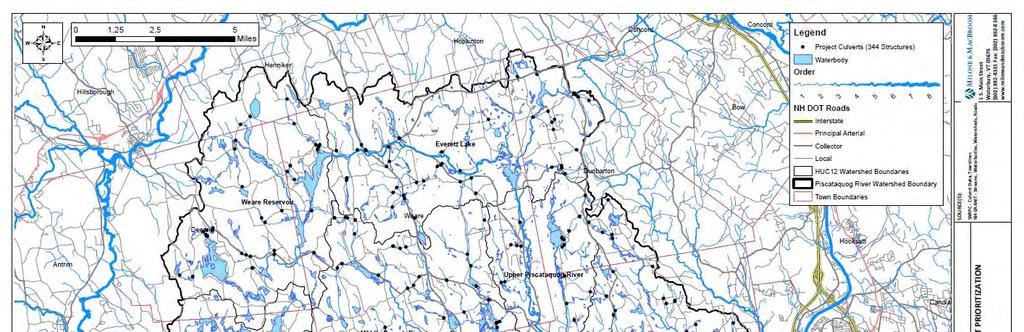
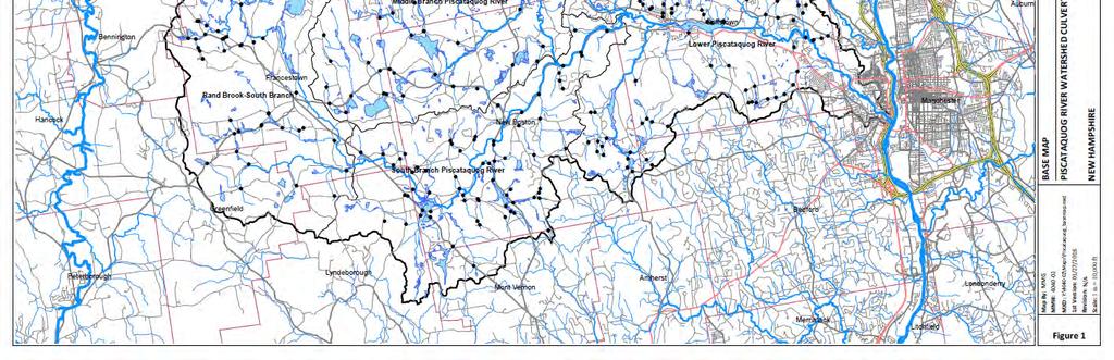
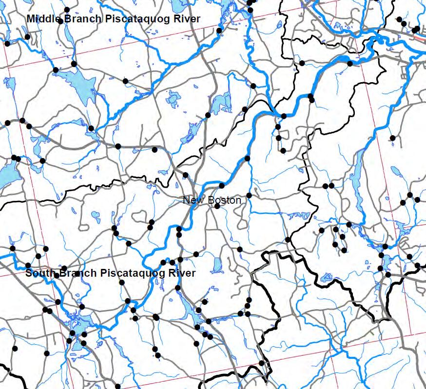
4 Project Goals 1. Create an easy to use Excel based tool for municipalities in prioritizing culvert replacements and stream crossing restorations. 2. The tool will be community driven with built in flexibility in weighing key environmental, engineering and road safety related factors in prioritizing road, stream crossing and culvert infrastructure upgrades prior to emergency repairs. 3. The aim is to get ahead of the storm and work with and train three municipalities in developing, field testing and implementing the tool The tool will be designed and available for all eleven municipalities located in the Piscataquog River Watershed.
 New")
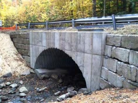
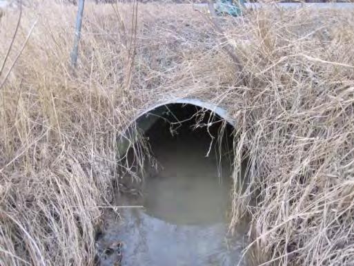
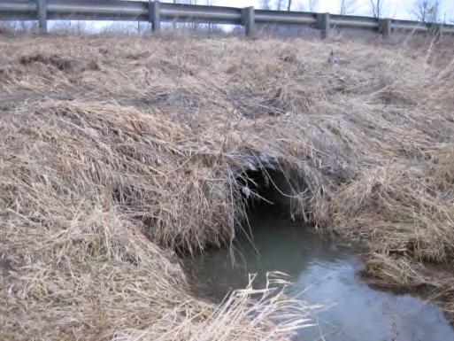
5 Former culvert (MMI, 2015) New culvert 5
6 Scope of Work 1. Project Planning and Conceptual Design 2. Project Development Team and Outreach 3. Design Screening Tool 4. Run and Test Model 5. Create User Friendly Instructions 6. Project Team Review 7. Project Summary and Town Reports 8. Concept Designs and Community Outreach 6
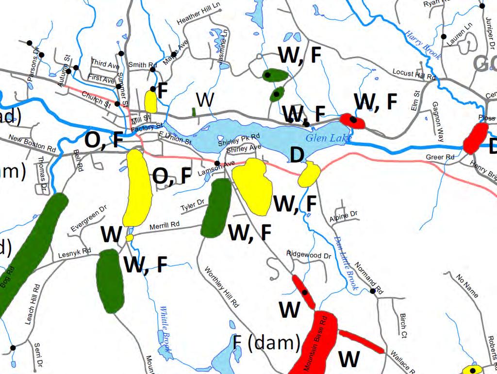
7 Existing Information 7


8 Existing Information 8 (SNHPC, TU, DES, 2015)
")
9 Existing Information 9 (SNHPC, TU, DES, 2015)
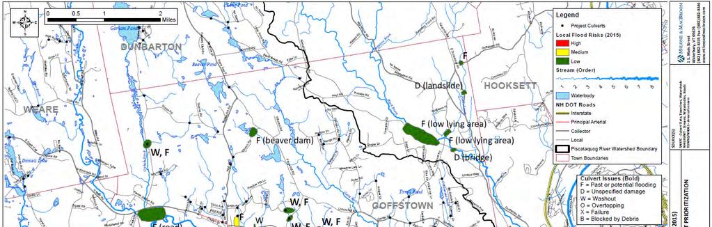
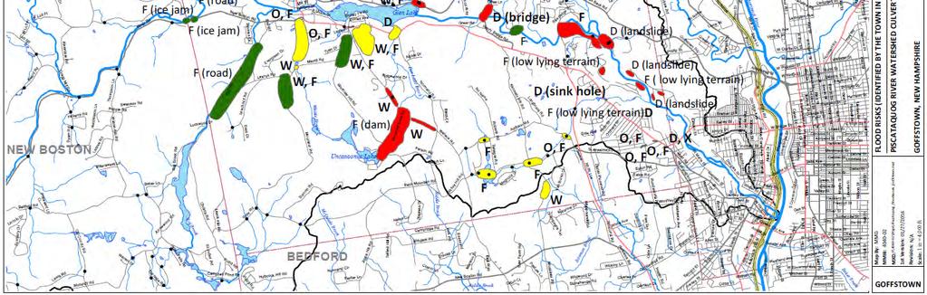
10 Existing Information 10

11 Geomorphic Compatibility Screen 11 (Schiff et al., 2008)

12 Incorporating Culvert Restoration into Paving 12 (MMI, 2013)
![Stream Power Total Stream Power (TSP) [W/m] =](/docs-images/74/69882673/images/13-0.jpg "*Q*S Specific Stream Power (SSP) [W/m 2 ] = *Q*S")

13 Stream Power Total Stream Power (TSP) [W/m] = *Q*S Specific Stream Power (SSP) [W/m 2 ] = *Q*S / w Source: Bagnold, 1966 Source: Brierley and Fryirs, 2005 Source: Kleinhans and van den Berg, 2010
14 Flood Sensitivity Coarse Screen (Schiff et al., 2015)
15 River Sensitivity Coarse Screen 15 (MMI, 2015)
16 Culvert Vulnerability Screening Vulnerability Score < 0.4 >=0.4 to 0.6 >=0.6 to 1 High Medium Low Specific Stream Power versus Bed Resistance Specific Stream Power (W/m 2 ) Dominant Particle Size (Bed Resistance) Silt Sand Gravel Cobble Boulder Bedrock Structure Width Structure Width / Channel Bankfull Width (%) < 50% 50 75% >75 100% > % >125% Change in Slope Local Channel Slope Structure Slope (feet / feet) > 0.03 and <= 0.03 <= 0.02 > 0.02 and <=0 >0 and <=0.02 >0.02 and <=0.03 > Sediment Continuity Upstrea m Bed Downstream Bed Erosion None Aggradation Aggradation None Erosion Structure Alignment Skewed Aligned Legend Highest Vulnerability Lowest Vulnerability (MMI, 2016)
17 Culvert Vulnerability Screening 17 (MMI, 2016)

18 Culvert Vulnerability Screening 18 (MMI, 2016)
19 Draft Screening Draft Culvert Scoring System (V.2) GC = Geomorphic compatibility (NHGS) combined with a variable describing the predicted relationship between stream power and bed resistance (see below). Risk STR = An indicator of the structure condition from field observations combined with the approximate hydraulic capacity (TU/SNHPC) (see below). AOP = Aquatic organism passage (TU/SNHPC) plus fisheries prioritization data (NHFG). C = Criticality of the structure such as essential links, public safety routes, proximity to infrastructure, paving schedules, etc. (Town) R = Overall risk that is the intersection between vulnerability and criticality. Specific Stream Power & Bed Resistance Specific Stream Power (W/m 2 ) Dominant Particle Size (Bed Resistance) Silt Sand Gravel Cobble Boulder Bedrock GC Geomorphic Compatibility Aquatic Organism Passage AOP STR Structure Condition and Approximate Hydraulic Capacity Criticality C NEW CONDITION OTHER CONDITION (Potentially bad condition) Hydraulic Capacity Category Hydraulic Capacity Category Flood Pass Transition Fail Flood Pass Transition Fail (RI year) Hw/D< >1.15 (RI year) Hw/D< > L H H 2 L H H 10 L H H 10 L H H 25 L M H 25 L H H 50 L M M 50 L H H 100 L M M 100 L M H Risk Scoring Examples Risk Fisheries Prioritization Data (NHFG) AOP Category (TU) wild book trout sculpin / trout 0 0 dace only none Green Gray Orange Lowest Risk Low Risk Moderate Risk High Risk Highest Risk 19 Red Prepared February 2016


20 20 Anticipated Screening Results
21 Draft Screening Add power / resistance to NH GC screen Specific Stream Power & Bed Resistance Specific Stream Power (W/m 2 ) Dominant Particle Size (Bed Resistance) Silt Sand Gravel Cobble Boulder Bedrock Prepared February 2016

22 Draft Screening 22 Prepared February 2016
23 Draft Screening Fisheries Information (from NHFG) Fish Category Fisheries Prioritization Data (NHFG) wild book trout AOP Category (TU) wild book trout sculpin / trout?? dace only none sculpin / trout?? dace only none Green Gray Orange Red 23 Prepared February 2016
24 Draft Screening Criticality (Identified by Town) Critical link Near public safety Near infrastructure Replacement need aligns with paving cycle High traffic volume Near village center Risk AOP not in risk screen Vulnerability Criticality Risk GC STR C R 24 Prepared February 2016
25 Additional Slides 25

26 Recent Design Guidance 26 (Schiff et al., 2014)

27 Project Area 27
28 Funding Sources NH Department of Safety and Homeland Security FEMA NH Department of Environmental Services Aquatic Resource Mitigation (ARM) Funding Local Capital Improvement Programming Local Conservation Funding Local Bonding 28

29 Existing Hydraulic Capacity Information Hw/D> >Hw/D>0.85 Hw/D<0.85 (TU and SNHPC, 2014) 29
")
30 Screening Culverts for Risk Reduction and AOP (MMI, 2014) VT116 30
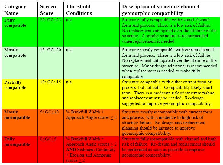

31 Geomorphic Compatibility Screen 31 (Schiff et al., 2008)

32 Retrofit Potential Screen 32 (MMI, 2008)
Culvert Prioritization Model: Aiding Communities in the Selection of Priority Restoration Projects
 Culvert Prioritization Model: Aiding Communities in the Selection of Priority Restoration Projects SNHPC Meeting January 24, 2017 1 Undersized Culverts! Culvert Sizes (~7,500 VT culverts) 6,000 5,000 69%
Stream Crossings II: Bridges, Culverts, Flood Resiliency, and Connectivity
 University of Massachusetts Amherst ScholarWorks@UMass Amherst International Conference on Engineering and Ecohydrology for Fish Passage International Conference on Engineering and Ecohydrology for Fish
REPLACING CULVERTS FOR FLOOD RESILIENCY AND AQUATIC CONNECTIVITY. Cheryl Bondi and Lori Sommer NHDES Aquatic Resource Mitigation Program
 REPLACING CULVERTS FOR FLOOD RESILIENCY AND AQUATIC CONNECTIVITY Cheryl Bondi and Lori Sommer NHDES Aquatic Resource Mitigation Program How do stream crossings impact aquatic ecosystems and public safety?
Stream Restoration at Road Crossings in Northern Wisconsin. Dale Higgins, USDA Forest Service
 Stream Restoration at Road Crossings in Northern Wisconsin Dale Higgins, USDA Forest Service Key Points Large # of road and trail stream crossings on the landscape Many crossings adversely impact streams
Amherst. University of Massachusetts - Amherst. Nathaniel Gillespie United State Department of Agriculture, Forest Service
 University of Massachusetts - Amherst ScholarWorks@UMass Amherst International Conference on Engineering and Ecohydrology for Fish Passage International Conference on Engineering and Ecohydrology for Fish
CROSBY BROOK RESTORATION STUDY BRATTLEBORO, VT
 Key Stakeholders: CROSBY BROOK RESTORATION STUDY BRATTLEBORO, VT Funded By: VT Dept. of Environmental Conservation VT Agency of Transportation (VTrans) Town of Brattleboro NEWEA Spring Meeting Omni Mt.
Wood-Pawcatuck Watershed Flood Resiliency Management Plan
 Wood-Pawcatuck Watershed Flood Resiliency Management Plan Project Steering Committee Meeting May 21, 2015 Wood-Pawcatuck Watershed Association Meeting Agenda 10:00 10:05 Welcome and Opening Remarks 10:05
Stream Simulation in Very Low Gradient Channels
 University of Massachusetts - Amherst ScholarWorks@UMass Amherst International Conference on Engineering and Ecohydrology for Fish Passage International Conference on Engineering and Ecohydrology for Fish
Dianne Timmins - NH Fish and Game Dept. 1 Rachelle Lyons - PSU Center for Business and Community Partnerships
 Watershed Scale Crossing Assessment to Promote Community Restoration Priorities Dianne Timmins - NH Fish and Game Dept 1 Rachelle Lyons - PSU Center for Business and Community Partnerships ARSCAP Team
Mike Jastremski, CFM Watershed Conservation Director
 Planning for Flood Resilient and Fish Friendly Road-Stream Crossings in CT s Northwest Hills Mike Jastremski, CFM Watershed Conservation Director Presentation Outline Project area Climate threats Field
In re: Town of Norwich Pool Dam Reconstruction, Stream Alteration Permit Application
 Agency of Natural Resources October 20, 2015 Neil R. Fulton Town Manager Town of Norwich P.O. Box 376 Norwich, VT 05055 In re: Town of Norwich Pool Dam Reconstruction, Stream Alteration Permit Application
PROJECT SCREENING MATRIX: A User s Guide
 Version 2.0 Page 1 of 7 November 9, 2010 PROJECT SCREENING MATRIX: A User s Guide BACKGROUND The Project Screening Matrix (Screening Matrix) is one of several tools that comprise the River Restoration
Wood-Pawcatuck Watershed Flood Resiliency Management Plan
 Wood-Pawcatuck Watershed Flood Resiliency Management Plan Project Steering Committee Kickoff Meeting March 26, 2015 Wood-Pawcatuck Watershed Association Meeting Agenda 10:00 10:05 Welcome and Opening Remarks
South St. Vrain / Hall Meadows Restoration Planning August 20, 2015
 South St. Vrain / Hall Meadows Restoration Planning August 20, 2015 Agenda Introductions Purpose & Goals of Meeting Planning Area Master Plan Restoration Planning: Cost Estimates, Grants, Scope, Timeline
Stream Restoration Raccoon Creek A Case Study
 Stream Restoration Raccoon Creek A Case Study Restoration of a Degraded Stream System Steven Glickauf Presentation Overview Stream Restoration Raccoon Creek Restoration Site Case Study Existing Conditions
Wood-Pawcatuck Watershed Flood Resiliency Management Plan Community Meeting October 20, 2016
 Wood-Pawcatuck Watershed Flood Resiliency Management Plan Community Meeting October 20, 2016 Wood-Pawcatuck Watershed Association Meeting Agenda 10:00 10:05 Introductions and Meeting Goals 10:05 10:15
NANEUM, WILSON, AND CHERRY CREEK WATERSHED ASSESSMENT
 NANEUM, WILSON, AND CHERRY CREEK WATERSHED ASSESSMENT Presentation for Voluntary Stewardship Program November 9, 2016 Watershed Assessment This Watershed Assessment is intended to develop a partnership
Flood Resiliency, Aquatic Organism Passage, Critical Infrastructure, and Economics A Case for Stream Simulation Design and ERFO Policy Changes
 Flood Resiliency, Aquatic Organism Passage, Critical Infrastructure, and Economics A Case for Stream Simulation Design and ERFO Policy Changes Presented by Robert Gubernick R.G. USDA Forest Service Region
Developing Tools for Hydromodification Management and Assessment
 Developing Tools for Hydromodification Management and Assessment Hydromodification: Channel Erosion Before Development After Development Increase in: - Imperviousness - Drainage Slope - Direct Runoff Decrease
REQUEST FOR CONSTRUCTION BIDS May 23, 2017
 REQUEST FOR CONSTRUCTION BIDS May 23, 2017 Cambridge Greenway Trail / Railroad Bridge Replacement Flood Mitigation Project 1.0 Project Background A former railroad bridge that currently carries the Cambridge
Stream Crossing Reconstruction on the Bog Dam Loop Road (FR15) Scoping Notice. Androscoggin Ranger District
 Scoping Notice. Androscoggin Ranger District") United States Department of Agriculture Forest Service White Mountain National Forest Stream Crossing Reconstruction on the Bog Dam Loop Road (FR15) Scoping Notice Androscoggin Ranger District Androscoggin
United States Department of Agriculture Forest Service White Mountain National Forest Stream Crossing Reconstruction on the Bog Dam Loop Road (FR15) Scoping Notice Androscoggin Ranger District Androscoggin
Case Study 15. Moonlight Crossing Concrete Box Vented Ford
 Appendix A Case Study 15 Case Study 15. Moonlight Crossing Concrete Box Vented Ford Location Northeastern California. Plumas National Forest. On Lights Creek, 8 miles north of Taylorsville, CA., Forest
Surface Water. Solutions for a better world
 1 Surface Water Solutions for a better world Our Surface Water Services Expertise Growing worldwide awareness of water scarcity has encouraged water preservation programs, better irrigation techniques
Partnering for Resilient Infrastructure and Ecosystems in Massachusetts
 Partnering for Resilient Infrastructure and Ecosystems in Massachusetts Northeastern Transportation & Wildlife Conference September 10 th, 2018 1 Tim Dexter, MassDOT Highway Division Brad Chase, MA Division
Aquatic Resource Mitigation Fund
 Aquatic Resource Mitigation Fund Lori Sommer- Mitigation Program Coordinator Land Resource Management Program NH Department of Environmental Services PRESENTATION OVERVIEW Brief overview on mitigation
Massachusetts River and Stream Crossing Standards: Technical Guidelines
 Massachusetts River and Stream Crossing Standards: Technical Guidelines August 6, 2004 INTRODUCTION As long and linear ecosystems, rivers and streams are very important for fish and other wildlife movements,
IMPROVING OUTCOMES FOR STREAM ALTERATION PROJECTS
 IMPROVING OUTCOMES FOR STREAM ALTERATION PROJECTS Bethany Matousek Inland Lakes and Streams Program Coordinator Wetlands, Lakes and Streams Unit DEQ Water Resources Division MatousekB@Michigan.gov 517-243-6421
Old Mill School Stream Restoration
 Project Overview This conceptual plan restores and stabilizes two consecutive reaches of a highly incised and unstable stream and reconnects them with the floodplain. The restoration reaches are part of
Temporary Stream Crossing
 Categories EC Erosion Control SE Sediment Control TC Tracking Control WE Wind Erosion Control Non-Stormwater NS Management Control Waste Management and WM Materials Pollution Control Legend: Primary Objective
Temporary Stream Crossing
 Temporary Stream Crossing NS-4 Objectives EC Erosion Control SE Sediment Control TR Tracking Control WE Wind Erosion Control Non-Stormwater NS Management Control Waste Management and WM Materials Pollution
Climate Ready Culverts. Funding
 Climate Ready Culverts Thomas P. Ballestero University of New Hampshire Stormwater Center 2016 INAFSM Annual Conference Florence, IN 7 9 Sep 2016 1 Funding 2 1 Culvert Hydraulics 3 Bridge Versus Culvert
OFFICE OF STRUCTURES MANUAL ON HYDROLOGIC AND HYDRAULIC DESIGN CHAPTER 3 POLICY AND PROCEDURES
 OFFICE OF STRUCTURES MANUAL ON HYDROLOGIC AND HYDRAULIC DESIGN CHAPTER 3 POLICY AND PROCEDURES April 28, 2016 Table of Contents 3.1 Introduction... 2 3.1.1 Purpose of Chapter 3... 2 3.1.2 Policy vs. Design
State of Vermont Culvert sizing based on the Stream Alteration General Permit
 State of Vermont Culvert sizing based on the Stream Alteration General Permit Northeastern Transportation and Wildlife Conference September 11, 2018 Todd Menees, PE River Management Engineer VT DEC Rivers
Local Flood Hazard Mitigation Program. A framework for hazard mitigation in the NYC West of Hudson Water Supply Watersheds
 Local Flood Hazard Mitigation Program A framework for hazard mitigation in the NYC West of Hudson Water Supply Watersheds Flood Hazard Mitigation Defined 2 2 Presentation Overview Why and how is the NYC
Town of Aurora Stream Management Master Plan PUBLIC INFORMATION CENTRE May 1 st, 2018
 Town of Aurora Stream Management Master Plan PUBLIC INFORMATION CENTRE May 1 st, 2018 Your comments are encouraged and appreciated, as this will provide us an opportunity to address project issues and
Developing a multi-metric habitat index for wadeable streams in Illinois (T-25-P-001).
.") T E C H N I C A L R E P O R T Developing a multi-metric habitat index for wadeable streams in Illinois (T-25-P-001). Annual Segment Report to the Illinois Department of Natural Resources. Laura L. Sass,
T E C H N I C A L R E P O R T Developing a multi-metric habitat index for wadeable streams in Illinois (T-25-P-001). Annual Segment Report to the Illinois Department of Natural Resources. Laura L. Sass,
Temporary Watercourse Crossing: Fords
 Temporary Watercourse Crossing: Fords DRAINAGE CONTROL TECHNIQUE Low Gradient Velocity Control Short Term Steep Gradient Channel Lining Medium-Long Term Outlet Control Soil Treatment Permanent [1] [1]
SECTION 6: MITIGATION STRATEGIES
 SECTION 6: MITIGATION STRATEGIES This section presents mitigation actions for Onondaga County to reduce potential exposure and losses identified as concerns in the Risk Assessment portion of this plan.
Holly Swartz and Jason Shirey
 Chapter 105 General Permits for Stream and Wetland Impacts DEP Ch. 105 CONTACTS FOR BERKS COUNTY: Holly Swartz and Jason Shirey What DEP Regulates Under Chapter 105 Waters of the Commonwealth, which includes
Case Study 19. Mill Creek Embedded Box Culvert Vented Ford
 Case Study. Mill Creek Embedded Box Culvert Vented Ford Location Southeast Missouri. Mark Twain National Forest; Houston-Rolla Ranger District. Southeast of Rolla, south of Interstate 44, off of State
Table D1: WC-R1 to WC-R3 (Wilket Creek Park)
") APPENDIX D Table D1: WC-R1 to WC-R3 (Wilket Creek Park) Category of Consideration Criteria Alternative 1 Do Nothing Alternative 2 Local Improvements Alternative 3 Channel Realignment Natural Geomorphic
APPENDIX D Table D1: WC-R1 to WC-R3 (Wilket Creek Park) Category of Consideration Criteria Alternative 1 Do Nothing Alternative 2 Local Improvements Alternative 3 Channel Realignment Natural Geomorphic
Introducing Act 64 - the Vermont Clean Water Act - and Vermont s Clean Water Goals
 Introducing Act 64 - the Vermont Clean Water Act - and Vermont s Clean Water Goals Marli Rupe, DEC Clean Water Initiative Program Asst. Manager February 22, 2016 Clean Waters are a Critical Community Asset
Struggles for Flood Resiliency and AOP in Rhode Island
 University of Massachusetts Amherst ScholarWorks@UMass Amherst International Conference on Engineering and Ecohydrology for Fish Passage International Conference on Engineering and Ecohydrology for Fish
Bluff Creek One Water
 Bluff Creek One Water The Bluff Creek Watershed has no lakes within its boundaries. As the westernmost watershed within the District, land use changes from agricultural to residential have occurred relatively
Case Study 5. Willow Creek Concrete Plank Ford
 Appendix A Case Study Case Study. Willow Creek Concrete Plank Ford Location Northeastern California. Plumas National Forest. Willow Creek. miles northwest of Portola, CA, on Spur Road 23N97Y off Forest
Use of WARSSS in Stream Restoration and Watershed Planning. Michigan Aquatic Restoration Conference 2015
 Use of WARSSS in Stream Restoration and Watershed Planning Michigan Aquatic Restoration Conference 2015 October 22, 2015 Use of WARSSS in Stream Restoration and Watershed Planning 1. Watershed Management
DECISION MEMO FOR CATEGORICAL EXCLUSION HOLY JIM CREEK CROSSING REPLACEMENT
 DECISION MEMO FOR CATEGORICAL EXCLUSION HOLY JIM CREEK CROSSING REPLACEMENT U.S.D.A. Forest Service Cleveland National Forest Trabuco Ranger District Orange County, California Background The current configuration
Sawmill Brook Culvert and Green Infrastructure Analysis
 Sawmill Brook Culvert and Green Infrastructure Analysis Looking at Impacts of Climate Change in Both a Coastal and Riverine Environment Mary Reilly, Grants Administrator Town of Manchester-by-the-Sea Massachusetts
The North Atlantic Aquatic Connectivity Collaborative (NAACC)
") The North Atlantic Aquatic Connectivity Collaborative (NAACC) Evaluating Road-Stream Crossings Across a Thirteen-State Region Jessie Levine September 14, 2016 NETWC Scale of the Problem Data on 9,064 crossings
The North Atlantic Aquatic Connectivity Collaborative (NAACC) Evaluating Road-Stream Crossings Across a Thirteen-State Region Jessie Levine September 14, 2016 NETWC Scale of the Problem Data on 9,064 crossings
Appendix D - Evaluation of Interim Solutions
 Appendix D - Evaluation of Interim Solutions D.1 Introduction The implementation of long-term improvements is projected to take 5 to 8 years. To reduce the number of years of flooding impacts, the partner
Fish Passage Assessment of Road-Stream Crossings in Cooks Creek Watershed Priority Projects and Conceptual Design Bucks County, Pennsylvania
 November 30, 2012 Bucks County Trout Unlimited c/o Joe Mihok 412 Manor Drive Dublin, PA 18917 Scientists, Engineers & Environmental Planners Designing Innovative Solutions for Water, Wetland and Soil Resource
Flood Hazard Assessment Report Falls Gulch, Larimer County, Colorado January 16, 2013
 United States Department of Agriculture Natural Resources Conservation Service Denver Federal Center Building 56, Room 2604 P.O. Box 25426 Denver, CO 80225 720-544-2818-OFFICE alton.albin@co.usda.gov Flood
Integrating Biodiversity & Infrastructure Priorities
 Integrating Biodiversity & Infrastructure Priorities Bill Napolitano Director of Environmental Planning, Southeastern Regional Planning and Economic Development District Jennifer Carlino Conservation Agent
Bellevue s Approach to Stormwater Management
 Bellevue s Approach to Stormwater Management By Don McQuilliams Operations Manager-Regulatory Compliance and Surface Water Bellevue Utilities Department City of Bellevue, Washington Bellevue, Washington
Session C7- Building on the $10 million/year H TAP program for culvert mitigation on national forest system lands
 University of Massachusetts - Amherst ScholarWorks@UMass Amherst International Conference on Engineering and Ecohydrology for Fish Passage International Conference on Engineering and Ecohydrology for Fish
Step-Pool Creation to Restore Fish Passage and Riparian Health
 Step-Pool Creation to Restore Fish Passage and Riparian Health Jenny Kindig Water Resources Engineer Denny Mengel, Senior Environmental Scientist Steve Miller, Water Resources Engineer Gloria Beattie,
CHATHAM PARK EXCEPTIONAL DESIGN EVALUATION
 CHATHAM PARK EXCEPTIONAL DESIGN EVALUATION 1 Chatham Park Basics 7,600 Acre Mixed Use Development 22,000 New Residences 22 Million Square Feet Commercial Space 60,000 Jobs 2,000+ Acres Open Space Estimated
LOCATION AND DESIGN DIVISION
 VIRGINIA DEPARTMENT OF TRANSPORTATION LOCATION AND DESIGN DIVISION INSTRUCTIONAL AND INFORMATIONAL MEMORANDUM GENERAL SUBJECT: CULVERT DESIGN SPECIFIC SUBJECT: COUNTERSINKING AND LOW FLOW CONSIDERATIONS
ILLINOIS URBAN MANUAL PRACTICE STANDARD TEMPORARY STREAM CROSSING (no.) CODE 975. Source: Hey and Associates, Inc.
 CODE 975. Source: Hey and Associates, Inc.") ILLINOIS URBAN MANUAL PRACTICE STANDARD TEMPORARY STREAM CROSSING (no.) CODE 975 Source: Hey and Associates, Inc. DEFINITION A bridge or culvert crossing installed across a stream or watercourse for short-term
ILLINOIS URBAN MANUAL PRACTICE STANDARD TEMPORARY STREAM CROSSING (no.) CODE 975 Source: Hey and Associates, Inc. DEFINITION A bridge or culvert crossing installed across a stream or watercourse for short-term
Stinson Beach Watershed Program
 Stinson Beach Watershed Program www.marinwatersheds.org Purpose The Board of Supervisors authorized the Department of Public Works to begin implementation of a County-wide Watershed Program on May 13,
REQUEST FOR CONSTRUCTION BIDS February 22, 2010
 REQUEST FOR CONSTRUCTION BIDS February 22, 2010 Roaring Branch Channel and Floodplain Restoration Project 1.0 Project Background Roaring Branch (watershed area ~ 41 square miles) flows generally west through
Final Project Report Big Creek Road Sediment Reduction Project, 03-DG
 TRINITY COUNTY NATURAL RESOURCES & LONG RANGE PLANNING 190 GLEN RD. P.O. BOX 1445 WEAVERVILLE, CA 96093 (530) 623-1458 ext.3409 mlancaster@trinitycounty.org Big Creek Road Sediment Reduction Project, 03-DG-11051400-053
Upper South Platte Source Water Assessment and Protection Plan
 Upper South Platte Source Water Assessment and Protection Plan Unpaved Roads and Trails Presented by: Kyle Hamilton, P.E. CH2M HILL May 9, 2014 Background Four watershed / unpaved roadway system assessments
Project Goals and Scoping
 Prepared for: Boulder County, Colorado Flood Planning & Preliminary Design Services for South St. Vrain Creek Restoration at Hall Ranch and Scoping May 24, 2016 Meeting with General Public In association
EcoStream Getting Our Feet Wet at Every Stage: Optimizing the Restoration of Urban Streams August 16, 2018
 EcoStream 2018 Getting Our Feet Wet at Every Stage: Optimizing the Restoration of Urban Streams August 16, 2018 Presentation Outline Planning/Design challenges, approaches, optimization Public Outreach/Stakeholder
404(b)(1) EVALUATION
(1) EVALUATION") 404(b)(1) EVALUATION SECTION 404(b)(1) EVALUATION DETAILED PROJECT REPORT AND ENVIRONMENTAL ASSESSMENT POMEROY SECTION 14 EMERGENCY STREAMBANK PROTECTION PROJECT POMEROY, OH I. INTRODUCTION As required
404(b)(1) EVALUATION SECTION 404(b)(1) EVALUATION DETAILED PROJECT REPORT AND ENVIRONMENTAL ASSESSMENT POMEROY SECTION 14 EMERGENCY STREAMBANK PROTECTION PROJECT POMEROY, OH I. INTRODUCTION As required
REQUEST FOR PROPOSAL
 REQUEST FOR PROPOSAL Submittal Deadline: 5:00 pm July 7, 2017 The Vermont Chapter of The Nature Conservancy invites proposals from qualified consultants for two fish passage restoration projects on culverts
Designing roads for fish, floods and foxes
 Designing roads for fish, floods and foxes Calculations 9 Swimming Plunging Flow & Leaping Occupied Velocity Prolonged > Capability Yes Swim in Burst Total Time in Burst Time to > Exhaustion Yes Barrier
OFFICE OF STRUCTURES MANUAL ON HYDROLOGIC AND HYDRAULIC DESIGN CHAPTER 11 EVALUATING SCOUR AT BRIDGES
 OFFICE OF STRUCTURES MANUAL ON HYDROLOGIC AND HYDRAULIC DESIGN CHAPTER 11 EVALUATING SCOUR AT BRIDGES APRIL 2011 Table of Contents 11.1 Introduction... 4 11.1 General......4 11.2 Qualifications of Personnel......4
DESIGN BULLETIN #16/2003 (Revised July 2007) Drainage Guidelines for Highways Under Provincial Jurisdiction in Urban Areas.
 Drainage Guidelines for Highways Under Provincial Jurisdiction in Urban Areas.") Drainage Guidelines for Highways Under Provincial Jurisdiction in Urban Areas. July 2007 Update to Design Bulletin #16/2003: Added under Design Criteria Culverts of 600mm diameter are commonly used to
Drainage Guidelines for Highways Under Provincial Jurisdiction in Urban Areas. July 2007 Update to Design Bulletin #16/2003: Added under Design Criteria Culverts of 600mm diameter are commonly used to
Case Study 12. Grubbs Concrete Slab Vented Ford
 Appendix A Case Study Case Study. Grubbs Concrete Slab Vented Ford Location North central California. Plumas National Forest. Mount Hough Ranger District. Grizzly Creek. 3 miles west of Bucks Lake, CA.
Preparing for the Storms: Municipal Adaptation for Climate Change Resiliency
 Preparing for the Storms: Municipal Adaptation for Climate Change Resiliency Massachusetts Association of Planning Directors Annual Conference UMass Lowell Inn and Conference Center June 6, 2013 E. Heidi
S.R. 4007, Section 14B PADEP Environmental Assessment Form. Enclosure C Description of Aquatic Habitat
 S.R. 4007, Section 14B PADEP Environmental Assessment Form Description of Aquatic Habitat Cresheim Creek is the only water resource that exists within the project area. No jurisdictional wetlands were
Floodplains are an important constituent of coho habitats and can be targeted for restoration. NetMap s advanced floodplain mapping tool calculates
 1 2 3 Floodplains are an important constituent of coho habitats and can be targeted for restoration. NetMap s advanced floodplain mapping tool calculates floodplains based on multiples of bankfull depths
PROJECT SCOPE OF WORK CITY OF TOWN AND COUNTRY STORMWATER PROGRAM
 PROJECT SCOPE OF WORK CITY OF TOWN AND COUNTRY STORMWATER PROGRAM Project Name: 1338 Thornhill Dr Project ID Number: 1-3 Problem: Creek bank erosion is occurring along from the northern property line at
Plan Rollout Presentation July 31, Michael G. Hahn, P.E., P.H. Chief Environmental Engineer. Southeastern Wisconsin Regional Planning Commission
 Plan Rollout Presentation July 31, 2014 Michael G. Hahn, P.E., P.H. Chief Environmental Engineer Southeastern Wisconsin Regional Planning Commission # 219703 Racine County Flooding Recommendations and
Forest Service AOP Policy and Program. John R. Kattell, P.E. Northern Region Structures Engineer
 Forest Service AOP Policy and Program John R. Kattell, P.E. Northern Region Structures Engineer AOP Policy and Program In years past: Aquatic passage to be considered where important and economically feasible.
Freight Street Development Strategy
 Freight Street Development Strategy Appendix B: Naugatuck River Floodplain Analysis Freight Street Development Strategy DECEMBER 2017 Page B-1 1.0 NAUGATUCK RIVER FLOODPLAIN AT FREIGHT STREET 1.1 Watershed
SOIL EROSION AND SEDIMENT CONTROL
 ARTICLE 20 SOIL EROSION AND SEDIMENT CONTROL 20.01 Activities Affected... 20-1 20.02 Exemptions to Soil Erosion and Sediment Control Requirements... 20-2 20.03 Basic Erosion Control Objectives... 20-3
OFFICE OF STRUCTURES MANUAL ON HYDROLOGIC AND HYDRAULIC DESIGN CHAPTER 11 EVALUATING SCOUR AT BRIDGES
 OFFICE OF STRUCTURES MANUAL ON HYDROLOGIC AND HYDRAULIC DESIGN CHAPTER 11 EVALUATING SCOUR AT BRIDGES May 26, 2015 Preface ABSCOUR 10 is the current version of the scour evaluation program used by the
Temporary Watercourse Crossing: Culverts
 Temporary Watercourse Crossing: Culverts DRAINAGE CONTROL TECHNIQUE Low Gradient Velocity Control Short Term Steep Gradient Channel Lining Medium-Long Term Outlet Control Soil Treatment Permanent Symbol
City of Fortuna Rohner Creek Flood Control Project
 City of Fortuna Rohner Creek Flood Control Project Presented To: Fortuna City Council Special Session April 26, 2013 Presented By: Merritt Perry, PE Jeremy Svehla, PE Robert Holmlund, AICP Presentation
National. Park Service Mr. Chris. and Flathead PO Box 638 Kalispell, MT 59903
 QUARTZ CREEK FISH EXCLUSION BARRIER PROJECT CONCEPTUAL DESIGN ALTERNATIVES REPORT Submitted To: National Park Service Mr. Chris Downs, Fishery Biologist Science Center, Glacier National Park West Glacier,
Rascal Goose. Reach 1. Rascal Goose. Reach 2. å å å. Main Goose Pit. Stream Reach 3. Main Goose Pit. Stream Reach 7
 434000 March 16 2014 434200 434400 ± 434600 434800 435000 Goose Lake 7269800 WRSA B 7269800 7270000 433800 GIS # BAC-06-180a 7270000 PROJECT # 0234411-0005 Rascal Goose Reach 1 Main Goose Pit Stream Reach
Stream Health. Stream Bugs Our Stream Health Communicators. Upper Nottawasaga River Stream Health. NVCA Science & Stewardship
 NVCA Science & Stewardship Stream Health Upper Nottawasaga River, 2015 Stream Bugs Our Stream Health Communicators Stream bugs (benthic macroinvertebrates) are organisms that spend much or all of their
Request for Qualifications
 Request for Qualifications Development of a Watershed Management and Restoration Plan for the Turkey River Watershed Bow, Concord, Dunbarton, and Hopkinton, New Hampshire January 2019 Upper Merrimack Watershed
Selection of Aquatic Organism Passage Design Methodology Based on Geomorphic Setting, Site Conditions, and Engineering Constraints
 Selection of Aquatic Organism Passage Design Methodology Based on Geomorphic Setting, Site Conditions, and Engineering Constraints Robert Gubernick R.G. USDA Forest Service Region 9 Eastern Region Acknowledgements
COTTON CREEK CULVERT REPLACMENT
 COTTON CREEK CULVERT REPLACMENT Integrating Mobility with Environmental Innovation Located along a scenic section of Highway 3/95 in British Columbia, Moyie Bluffs, a 6.5 km stretch of inland highway had
Moonlight Aquatic Organism Passage Project
 Notice of Proposed Action Moonlight Aquatic Organism Passage Project Mt. Hough Ranger District Plumas National Forest Plumas County, California Figure 1. Hungry 1 aquatic organism passage outlet showing
Hydromodification Management Measures
 Chapter 7 Hydromodification Management Measures This Chapter summarizes the requirements for controlling erosive flows from development projects. 7.1 Why Require Hydromodification Management? Changes in
Hydromodification Management Measures
 Chapter 7 Hydromodification Management Measures This Chapter summarizes the requirements for controlling erosive flows from development projects. 7.1 Why Require Hydromodification Management? Changes in
Appendix H: Stream Habitat Assessment
 Appendix H: Stream Habitat Assessment H CH2MHill and Greenways Incorporated conducted Stream Habitat Assessments on several streams throughout Wake County to determine the affect of development density
Gulf of Mexico Hydrological Restoration Criteria for Identifying and Prioritizing Projects
 Gulf of Mexico Hydrological Restoration Criteria for Identifying and Prioritizing Projects Definition of hydrological restoration for this Partnership To remove or modify anthropogenic barriers to restore
Sizing Hydraulic Structures in Cold Regions to Balance Fish Passage, Stream Function, and Operation and Maintenance Cost
 Sizing Hydraulic Structures in Cold Regions to Balance Fish Passage, Stream Function, and Operation and Maintenance Cost Matt Blank, WTI-MSU David Dockery, Wild Rivers Consulting Chrissy Pohl, BPXA 1 Background
STORM DRAINAGE DESIGN MANUAL
 Appendix I STORM DRAINAGE DESIGN MANUAL by: SUNGATE DESIGN GROUP, P.A. GEN ERAL DESIGN STAN DARDS AN D POLICIES 1. STREET AND LOCAL DRAINAGE Discharge estimates for specified design storms shall be calculated
Conceptual Design and Feasibility of a Natural Fishway at the Fremont BART Weir, Alameda Creek, California
 Conceptual Design and Feasibility of a Natural Fishway at the Fremont BART Weir, Alameda Creek, California Final Report September 2005 Prepared by Center for Ecosystem Management and Restoration, Oakland,
INTERMEDIATE BMI ASSESSMENT TIER 2 FIELD SHEET
 INTERMEDIATE BMI ASSESSMENT TIER 2 FIELD SHEET PHYSICAL PARAMETERS ASSESSMENT FIELD SHEET ALL TIERS NAME: DATE: TIME: STREAM OR RIVER NAME: WATERSHED NAME: TOWN: WEATHER PRESENT PAST 48 HOURS SITE DESCRIPTION
Northern Forest Watershed Incentives Project:
 Northern Forest Watershed Incentives Project: Using Incentives to Connect Forests, Water, and Communities ACES Todd Gartner, M.F. Senior Associate Conservation Incentives and Markets tgartner@wri.org December
FISH COLLECTION PERMIT SUMMARY REPORT FOR PERMIT NO.: CB
 North/South Consultants Inc. 440, 1121 Centre St. NW Calgary, Alberta T2E 7K6 Tel: (403) 410-4068 Fax: (403) 410-5633 Email: cfazakas@nscons.ca Web: www.nscons.ca FISH COLLECTION PERMIT SUMMARY REPORT
2012 Mill Creek Watershed Habitat Assessment Level 3 Project Study Plan Results
 2012 Mill Creek Watershed Habitat Assessment Level 3 Project Study Plan Results Cranberry Run This project study plan was financed through a Sub-grant from the Ohio EPA with funds from the State of Ohio.