Source Water Protection Plan HARPERS FERRY WATER WORKS
|
|
|
- August Hoover
- 6 years ago
- Views:
Transcription

1 Source Water Protection Plan HARPERS FERRY WATER WORKS PWSID WV JEFFERSON COUNTY 4/21/2016 Prepared by: Harpers Ferry Water Works and Advanced Land and Water, Inc.
2
3 Table of Contents Purpose... 1 What are the benefits of preparing a Source Water Protection Plan (SWPP)?... 2 Background: WV Source Water Assessment and Protection (SWAP) Program... 2 State Regulatory Requirements... 3 System Information... 3 Water Treatment and Storage... 4 Delineations... 7 Protection Team... 8 Potential Significant Sources of Contamination Confidentiality of PSSCs Local and Regional PSSCs Prioritization of Threats and Management Strategies Implementation Plan for Management Strategies Education and Outreach Strategies Contingency Plan Response Networks and Communication Operation During Loss of Power Future Water Supply Needs Water Loss Calculation Early Warning Monitoring System Single Source Feasibility Study Communication Plan Emergency Response Short Form Conclusion... 31
4 List of Tables Table 1. Population Served by the Harpers Ferry Water System... 4 Table 2. The Harpers Ferry Water System Water Treatment Information... 5 Table 3. The Harpers Ferry Water System Surface Water Sources... 6 Table 4. The Harpers Ferry Water System Groundwater Sources... 6 Table 5. Source Water Protection Area Delineation Information... 8 Table 6. Protection Team Member and Contact Information Table 7. New Locally Identified Potential Significant Sources of Contamination Table 8. Priority PSSCs or Critical Areas Table 9. Priority PSSC Management Strategies Table 10. Education and Outreach Implementation Plan Table 11. The Harpers Ferry Water System Water Shortage Response Capability Table 12. Generator Capacity Table 13. Future Water Supply Needs for the Harpers Ferry Water System Table 14. Water Loss Information Table 15. Early Warning Monitoring System Capabilities Appendices Appendix A. Figures Appendix B. Early Warning Monitoring System Forms Appendix C. Communication Plan Appendix D. Single Source Feasibility Study Appendix E. Supporting Documentation E-1. ALWI PSSC Update and Source Inspection E-2. Locally Identified PSSC Database Search E-3. Harpers Ferry Water System Previous SWPP E-4. Harpers Ferry Water System Protection Team Meeting Minutes E-5. Emergency Response Plan Signature Page E-6. Engineering Evaluation E-7. Railroad Emergency Response Trainings and Services
5 SOURCE WATER PROGRAM ACRONYMS AST BMP ERP GWUDI LEPC OEHS/EED PE PSSCs PWSU RAIN RPDC SDWA SWAP SWAR SWAPP SWP SWPA SWPP WARN WHPA WHPP WSDA WVBPH WVCA WVDEP WVDHHR WVDHSEM ZCC ZPC Aboveground Storage Tank Best Management Practices Emergency Response Plan Ground Water Under the Direct Influence of Surface Water Local Emergency Planning Committee Office of Environmental Health Services/Environmental Engineering Division Professional Engineer Potential Source of Significant Contamination Public Water System Utility River Alert Information Network Regional Planning and Development Council Safe Drinking Water Act Source Water Assessment and Protection Source Water Assessment Report Source Water Assessment and Protection Program Source Water Protection Source Water Protection Area Source Water Protection Plan Water/Wastewater Agency Response Network Wellhead Protection Area Wellhead Protection Program Watershed Delineation Area West Virginia Bureau for Public Health West Virginia Conservation Agency West Virginia Department of Environmental Protection West Virginia Department of Health and Human Resources Division of Homeland Security and Emergency Management Zone of Critical Concern Zone of Peripheral Concern
6 Purpose The goal of the West Virginia Bureau for Public Health (WVBPH) Source Water Assessment and Protection (SWAP) program is to prevent degradation of source waters which may preclude present and future uses of drinking water supplies, to provide safe water in sufficient quantity to users. The most efficient way to accomplish this goal is to encourage and oversee source water protection at a local level. Many aspects of source water protection are best addressed by engaging local stakeholders and local government officials. The intent of this document is to describe what Harpers Ferry Water Works has done, is currently doing, and plans to do to protect its source of drinking water. Although this water system treats water to meet federal and state drinking water standards, conventional treatment does not fully eradicate all potential contaminants. Treatment that goes beyond conventional methods is often very expensive to implement, maintain and operate. By completing this plan, Harpers Ferry Water Works acknowledges that implementing measures to prevent contamination of system water sources can be a relatively economical way to help protect drinking water in ways that it can continue to be provided to customers, reliably and safely. 1
7 What are the benefits of preparing a Source Water Protection Plan (SWPP)? Fulfills the West Virginia state requirement for the public water utilities to complete or update their source water protection plan. Provides a means for identification and prioritization of potential threats to sources of drinking water; and the establishment of strategies to minimize the threats. Establishes plans for emergency response to incidents that may come to compromise the water supply source(s) by contamination or depletion, and includes the manner in which the public, state, and local agencies will be notified of such an occurrence. Evaluates and establishes plans for future expansion and development of water resources, including the need to identify secondary sources of water. Ensures optimal treatment conditions exist to provide the safest and highest quality drinking water to customers at the lowest possible cost. Provides opportunities for funding to improve water system infrastructure, purchase land in the protection area, and for other improvements to either the sources, or their associated Source Water Protection Areas (SWPAs). Background: WV Source Water Assessment and Protection Program Since 1974, the federal Safe Drinking Water Act (SDWA) has set minimum standards on the construction and operation of public water systems, including Harpers Ferry Water Works, as well as the quality of finished water provided to the public. In 1986, Congress amended the SDWA. A portion of those amendments were designed to protect the source water contribution areas around ground water supply wells. This program eventually became known as the Wellhead Protection Program (WHPP). The purpose of the WHPP is to prevent pollution of source water supplying groundwater sources relied upon by public water systems. The Safe Drinking Water Act Amendments of 1996 expanded the concept of wellhead protection to include surface water sources under the umbrella term of Source Water Protection. The amendments encourage states to establish SWAP programs to protect all public drinking water supplies (both surface water and groundwater sources). As part of this initiative, states must explain how protection areas for each public water system are delineated, how potential contaminant sources are inventoried, and how susceptibility ratings are established. In 1999, the WVBPH published the West Virginia SWAP Program, which was endorsed by the United States Environmental Protection Agency. Over the next few years, WVBPH staff completed an assessment (i.e., delineation, inventory and susceptibility analysis) for all of West Virginia s public water systems. Each public 2
8 water system was sent a copy of its assessment report. Information regarding assessment reports for Harpers Ferry Water Works can be found in Table 1. State Regulatory Requirements On June 6, 2014, and a of the Code of West Virginia, 1931,was reenacted and amended by adding three new sections, designated c, d and e. The changes to the code outline specific requirements for public water utilities that draw water from surface water sources or Ground Water Under the Direct Influence of Surface Water (GWUDI) sources. Under the amended and newly added codes, each existing public water utility operating surface water and/or GWUDI sources must have completed or updated a Source Water Protection Plan (SWPP) by July 1, 2016, and must continue to update their plan every three years. Existing SWPPs have been developed for many public water utilities in the past. If available, these SWPPs were reviewed and considered in the development of this updated plan. Any new water system established after July 1, 2016 must submit a SWPP before operations commence. A new plan is also required when there is a significant change in the Potential Sources of Significant Contamination (PSSC) within the Source Water Protection Area (SWPA), which includes the Zone of Critical Concern (ZCC) for surface sources. The code also requires that public water utilities include details regarding PSSCs, protection measures, system capacities, contingency plans, and communication plans in their SWPP. Before a SWPP can be approved, the local health department and public will be invited to contribute information and provide comments for consideration. In some instances, public water utilities may be asked to conduct independent studies of the SWPA and specific threats within their SWPA to gain further insight about the origin of their water for the purpose of developing strategies to better protect these vital resources. System Information Harpers Ferry Water Works is classified as a state regulated public utility and operates a community public water system. A community public water system is a system that regularly supplies drinking water from its own sources to at least 15 service connections used by year round residents, or regularly serves 25 or more people throughout the entire year. Information on the population served by this utility is presented in Table 1 below. 3
9 Table 1. Population Served by Harpers Ferry Water Works Administrative office location: 1000 Washington St., Harpers Ferry, WV Is the system a public utility, according to the Public Service Commission rule? Yes Date of Most Recent Source Water Assessment Report (SWAR): 2006 Date of Most Recent Source Water Protection Plan (SWPP): 2011 Population served directly: 2,122 customers on 814 metered connections Bulk Water Purchaser Systems: System Name PWSID Number Population None Total Population Served by the Utility: 2,122 Does the utility have multiple source water protection areas (SWPAs)? How many SWPAs does the utility have? Yes 3; the utility has one ZCC for its primary source, Elks Run, and a second ZCC for its backup source, the Potomac River. The utility also has a delineated capture zone for Town Spring, which discharges directly into Elks Run and has some overlap with the existing Elks Run ZCC. Water Treatment and Storage As required, Harpers Ferry Water Works has assessed their system (e.g., treatment capacity, storage capacity, unaccounted for water, contingency plans) to evaluate their ability to provide drinking water and protect public health. Table 2 contains information on the water treatment methods and capacity of the utility. Information about the surface sources from which Harpers Ferry Water Works draws water can be found in Table 3. Information regarding the utilities only groundwater source, Town Spring, which discharges directly into Elks Run, is provided in Table 4. 4
10 Table 2. Harpers Ferry Water Works Water Treatment Information Water Treatment Processes (List All Processes in Order) Pre-Sedimentation, Coagulation, Flocculation, Sedimentation, Filtration, Disinfection, Fluoridation Current Treatment Capacity (gal/day) 500,000 Current Average Production (gal/day) 215,000 Maximum Quantity Treated and Produced (gal) 315,000 Minimum Quantity Treated and Produced (gal) 170,000 Average Hours of Operation 11.5 hours/day Maximum Hours of Operation in One Day 16 Minimum Hours of Operation in One Day 8 Number of Storage Tanks Maintained 3 Total Gallons of Treated Water Storage (gal) 991,000 Total Gallons of Raw Water Storage (gal) 77,000 (in the pre-sedimentation basin) 5
11 Table 3. Harpers Ferry Water Works Surface Water Sources Intake Name SDWIS # Local Name Describe Intake Name of Water Source Date Constructed/ Modified Frequency of Use (Primary/ Backup/ Emergency) Activity Status (Active/ Inactive) Elks Run Intake TP001 Elks Run Consists of a small surface impoundment which diverts water into a concrete collection box protected/filtered by two stainless steel screens. Elks Run 1942 Primary Active Potomac River Intake TP001 Potomac The intake is located near the base of the Potomac River, approximately 200 feet offshore. An 8-inch transmission line runs out to a 10 x10 collection box. Potomac River 1985 Backup Inactive, but tested monthly Table 4. Harpers Ferry Water Works Groundwater Sources Does the utility blend with groundwater? Yes, indirectly. The pipeline from the spring to the water treatment plant has not worked for at least four years. Water from the spring now discharges into Elks Run upgradient of the utility s surface water intake, thereby contributing to the water quality of the stream. According to the West Virginia Rural Water Association, flow from the Town Spring is derived from a fracture system north of the spring, which is influenced by an overlying losing stream. The recharge area for the spring approximates 186 acres, and partially overlaps the existing ZCC delineation. Well/Spring Name SDWIS # Local Name Date Constructed/ Modified Completion Report Available (Yes/No) Well Depth (ft) Casing Depth (ft) Grout (Yes/No) Frequency of Use (Primary/ Backup/ Emergency) Activity Status (Active/ Inactive) Harpers Ferry Spring Town Spring N/A N/A N/A No Indirectly primary Inactive but contributing 6
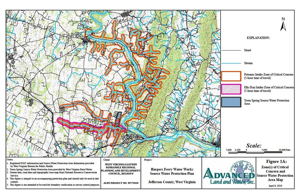
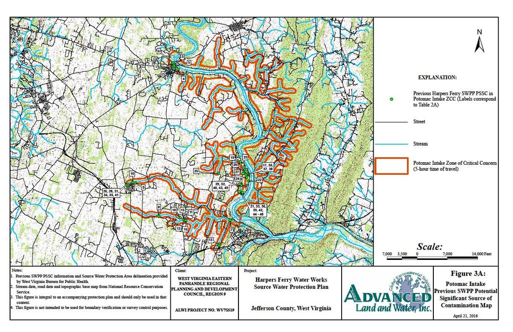
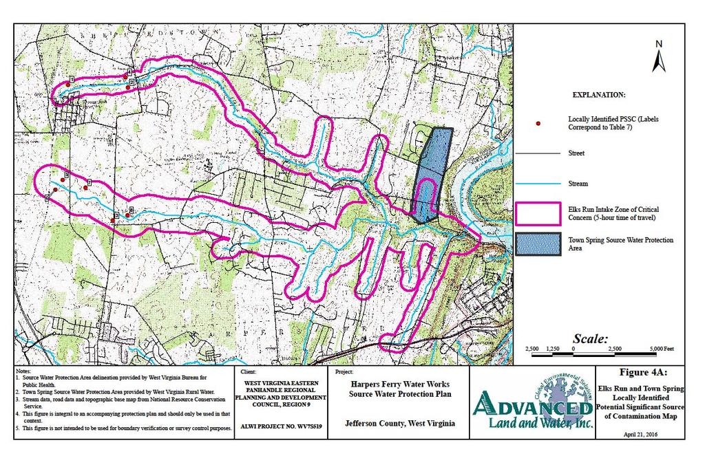
12 Delineations For surface water systems, defining a Watershed Delineation Area (WSDA) entails identifying and mapping the drainage basin that potentially supplies water to a point of interest. For surface water sources, this corresponds to a surface water intake. Oftentimes, watershed delineations are based on topographic maps, and are created by tracing and mapping the topographic high points that act as surface water and, presumably, groundwater divides relative to other drainage basins. Surface water sources are susceptible to contamination because they are exposed to the atmosphere and other sources of pollution located at the land surface. Unlike most groundwater sources, they also lack a natural, subsurface protective barrier from contamination, such as soil media that might filter or retain some pollutants. Accidental spills, releases, sudden precipitation events that result in overland runoff, or storm sewer discharges can allow pollutants at the land surface to readily enter surface water bodies and potentially contaminate the source of drinking water at the intake. For regulatory purposes, the SWPA for surface water sources is distinguished as the Zone of Critical Concern (ZCC). The WSDA includes the entire watershed area upgradient of the intake, to either the political boundary that is the West Virginia state line, or a topographic divide. The ZCC for a public surface water supply is a corridor along streams within the watershed that warrants more detailed scrutiny due to its proximity to the surface water intake and the intake s susceptibility to potential contaminants within that corridor. The ZCC is determined using a mathematical model that accounts for stream flows, gradient and topography. The length of the ZCC is based on a five-hour time-of-travel of water in the streams (and associated tributaries) to the surface water intake, plus an additional one-quarter mile below the water intake. The width of the ZCC is 1,000 feet measured horizontally from each bank of the principal stream and 500 feet measured horizontally from each bank of the tributaries draining into the principal stream. The ZPC for a public surface water supply source is a corridor along streams within a watershed that warrants scrutiny due to its proximity to the surface water intake and the intake s susceptibility to potential contaminants within that corridor. The ZPC is determined using a mathematical model that accounts for stream flows, gradient and topography. The length of the ZPC is based on an additional five-hour time-of-travel of water in the streams beyond the perimeter of the ZCC, which creates a protection zone of ten hours above the water intake. The width of the ZPC is 1,000 feet measured horizontally from each bank of the principal stream and 500 feet measured horizontally from each bank of the tributaries draining into the principal stream. For groundwater supplies, BPH makes use of two types of SWPA delineations: 1) wellhead delineations and 2) conjunctive delineations. Conjunctive delineations are developed for supplies identified as GWUDI sources. A Wellhead Protection Area (WHPA) is determined to be the area contributing to the recharge of the groundwater 7
13 source (well or spring), within a five-year time of travel. A conjunctive delineation combines a WHPA for the hydrogeologic recharge area (five-year time of travel) and an additionally connected area surrounding a surface water body that contributes water to a groundwater source. Conjunctive delineations, therefore, have been created for GWUDI sources. Information and maps of the ZCC (which we will refer to as the SWPA in this document), for this public water supply were provided to the utility and are attached to this report see Appendix A Figures. Other information about the WSDA is shown in Table 5. Table 5. Watershed Delineation Information Source Name Elks Run Potomac River Size of WSDA (Acres) 11,481 4,035,042. River Watershed Name (8-digit HUC) Size of Zone of Critical Concern (Acres) Conococheague-Opequon (HUC ) 2,573 10,685 Size of Zone of Peripheral Concern (Acres) (Include ZCC area) Method of Delineation for Groundwater Sources Area of Wellhead Protection Area (Acres) 2,515 Acres; The ZPC is similar in size to the ZCC because the ZCC extends to the headwaters of Elks Run. The WHPA for Town Spring, which contributes flow to Elks Run, is based on the recharge area and hydrogeologic studies performed using rhodamine dye. The recharge area is determined by dividing the annual spring discharge (gpm) by the annual recharge rate (in gallons per square mile). 186 acres for Town Spring. Note: This delineation has overlap with the ZCC for the proximal tributary to Elks Run. 26,674 Acres N/A; Surface water source N/A; Surface water source Protection Team Communities with successful SWPPs form a Protection Team to help develop and implement management and protection strategies. A Protection Team provides a broader level of oversight of the source water protection effort and includes individuals familiar with protective strategies. Active team members for Harpers Ferry Water Works include: water supply staff, the Town mayor, representatives from the Harpers Ferry Water Commission, representatives from the West Virginia Department Of 8
14 Environmental Protection and West Virginia Conservation Agency, and other local government officials, including the director of the planning department. A complete list of Protection Team members can be found in Table 6. Some government and business agencies were unable to participate in this iteration of the source water protection effort. Their participation should be sought in future iterations of the SWPP, which is updated at least every three years or as significant changes occur within the SWPA (i.e., changes to PSSCs or sources of water). With Harpers Ferry Water Works oversight and approval, Advanced Land and Water, Inc. (ALWI) assembled the Protection Team. Members were provided the opportunity to contribute to the development of the SWPP. The Protection Team reviewed the system s existing Source Water Assessment Reports (SWARs), included as Appendix E-3 of this report, as well as newly-collected PSSC data to make informed decisions on potential threats, protective measures, and implementation actions. The Protection Team will continue to be responsible for updating the SWPP in the future and documenting their efforts to engage local stakeholders. 9
15 Table 6. Protection Team Member and Contact Information Name Representing Title Phone Number Josh Carter Harpers Ferry Water Works Water System Manager - - Barbara Humes Harpers Ferry Water Commission Chairperson - - Gregory Vaughn Town of Harpers Ferry Mayor - - Laurel Drake Harpers Ferry Water Commission - - Alana Hartman WVDEP Watershed Improvement Branch Environmental Resources Analyst - - Suzy Campbell West Virginia Conservation Agency Conservation Specialist - - John D Brown Harpers Ferry Police Department Chief of Police - - Monica Whyte West Virginia Bureau for Public Health Environmental Resources Specialist - - Jennifer M. Brockman* Jefferson County Department of Planning and Zoning Director of Planning and Zoning - - Barbara Miller* Jefferson County Commission OHSEM Director - - Eric Bell* Jefferson County Commission Commissioner, Harpers Ferry District - - David Lillard* West Virginia Rivers Coalition Special Projects Manager - - Date of first protection Team Meeting March 18, 2016 Efforts to inform and engage local stakeholders and explain absence of recommended stakeholders: A list of local stakeholders invited to join the Protection Team is provided in Appendix E-4. Reasons for their absence are explained therein. *These representatives could not attend the first Protection Team meeting, but have expressed interest in assisting with the source water protection effort. 10
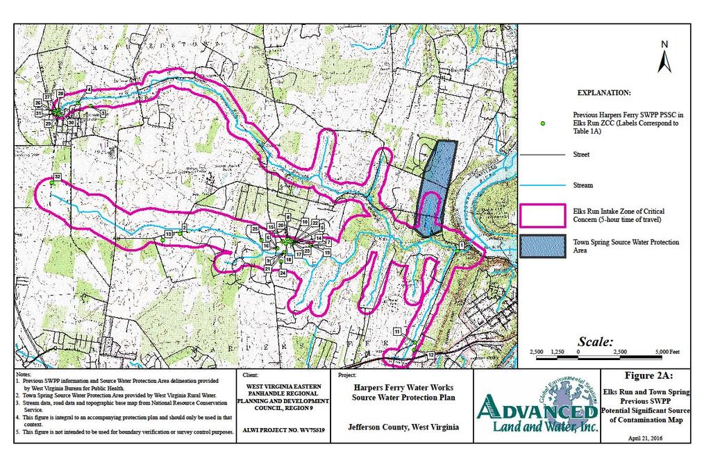
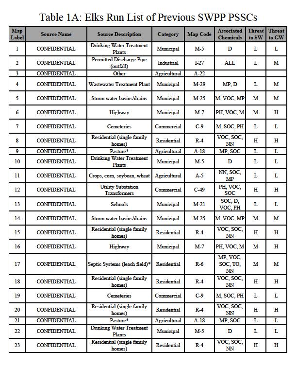
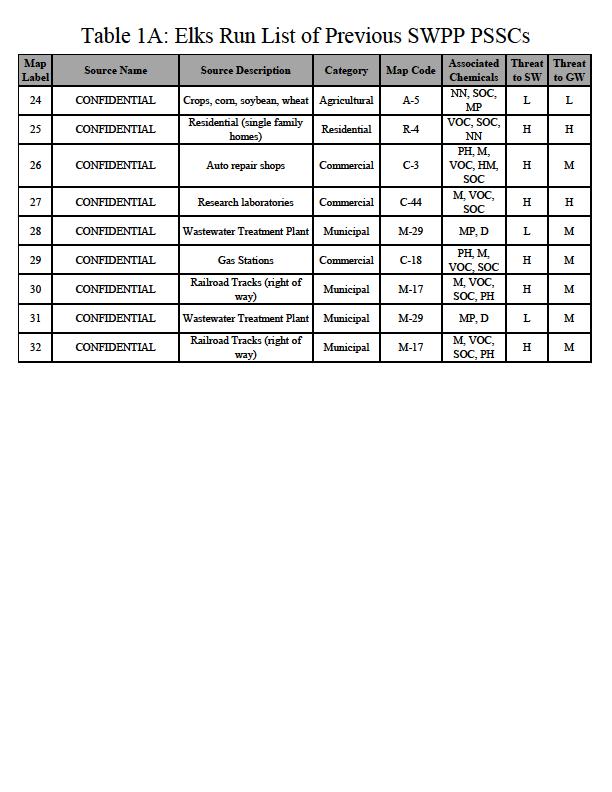
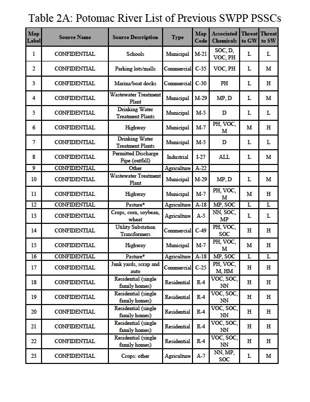
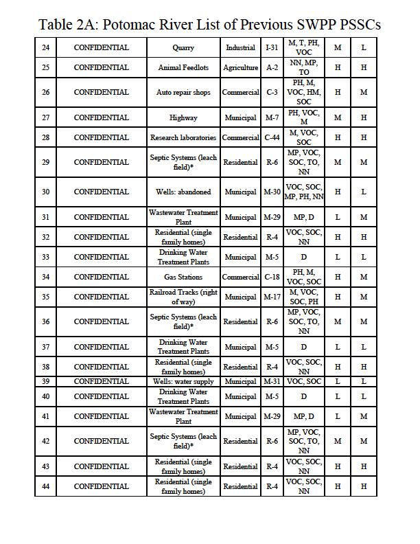
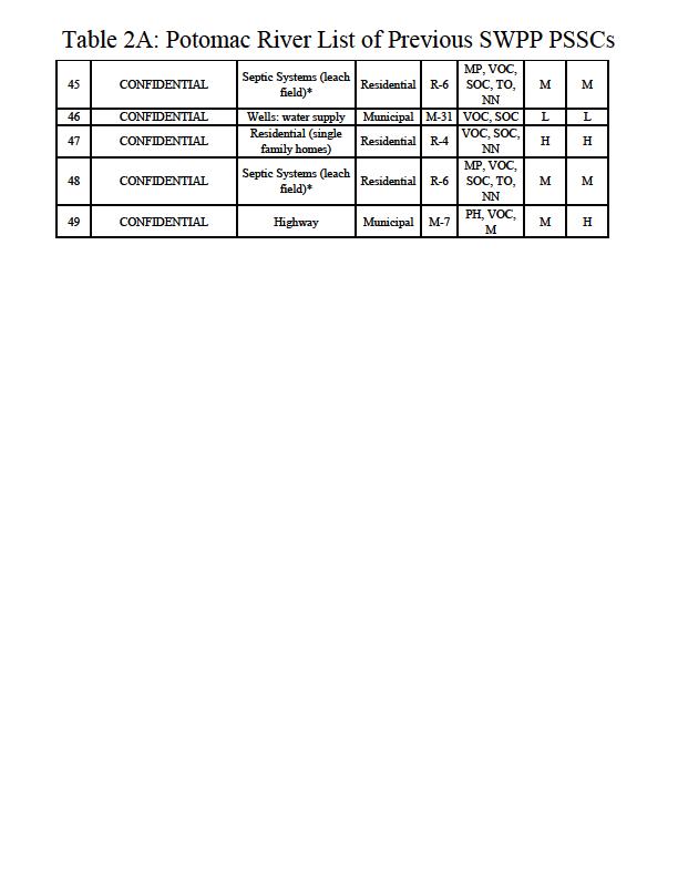
16 Potential Sources of Significant Contamination This SWPP provides a comprehensive list of the Potential Sources of Significant Contamination (PSSCs) contained within the SWPA (specifically the Elks Run ZCC and Town Spring recharge area), based upon information obtained from the WVBPH, working in cooperation with the Department of Environmental Protection (WVDEP) and the Division of Homeland Security and Emergency Management (WVDHSEM). A facility or activity is listed as a PSSC if it has the potential to release a contaminant that could potentially impact a nearby public water supply. This does not necessarily indicate that any release has occurred, presently or historically. The database information that utilities received of PSSCs located in their SWPA is organized into two types: 1) SWAP PSSCs, and 2) Regulated Data. SWAP PSSCs are those that have been collected and verified by the WVBPH SWAP Program during previous field investigations to form the SWARs and SWPPs. Typical means of identifying and/or confirming the existence of previously identified PSSCs involves performing a desktop Geographic Information System (GIS) analysis, in which a group performs a digital, desktop reconnaissance of potential hazards that can be identified and/or verified using a combination of recent orthophotography and state-provided PSSC database information. Regulated PSSCs are derived from federal and state regulated databases, and may include data from WVDEP, US Environmental Protection Agency, WVDHSEM, and from other state data sources. There are several criteria for which a facility may be named on the WV BPH Regulated Databases (i.e., storage of hazardous materials, stormwater management, etc.). As a result, some facilities may appear as duplicates in the tables presented in Appendix A. Confidentiality of PSSCs A list of the PSSCs contained within the SWPA should be included in this SWPP. However, the exact location, characteristics and approximate quantities of contaminants only were made known to a select designee of the public water utility. This representative has maintained, and will continue to maintain this information in a confidential manner. In the event of a chemical spill, release or other related emergency, information pertaining to such an event will immediately be disseminated to appropriate emergency responders. The designee for Harpers Ferry Water Works is identified in the communication planning section of the SWPP. PSSC data from some agencies (ex. WVDHSEM, WVDEP, etc.) may be restricted due to the confidential nature of the data. However, geospatial data has been provided to the public water utility s selected designee. To obtain specific details regarding contaminants (such as information included in Tier II reports), the water utility will continue to contact local emergency agencies, directly. Maps and lists of the Non-Confidential SWAP and Regulated PSSCs are provided in Appendix A Figures. 11
17 Local and Regional PSSCs For the purposes of this SWPP, local PSSCs are those that are identified by the Harpers Ferry Protection Team, consultants to Harpers Ferry Water Works, or local stakeholders in addition to the PSSCs lists distributed by the WVBPH and other agencies. Local PSSCs may be identified for two main reasons. The first is that it is possible that threats exist from unregulated sources and land uses that have not already been inventoried and do not appear in regulated databases. For this reason each public water utility should conduct periodic investigations of their protection area for local PSSCs. A PSSC inventory should identify all contaminant sources and land uses in the delineated ZCC. The second reason local PSSCs are identified is because public water utilities may consider expanding the PSSC inventory effort outside of the SWPA and further into the WSDA, if necessary, to properly identify threats that could impact their drinking water supply source(s). As the utility considers threats in the watershed they may consider collaborating with nearby communities to identify and manage regional PSSCs. When conducting local and regional PSSC inventories, some sources may be obvious, such as above ground storage tanks, landfills, livestock confinement areas, highway or railroad right of ways, and sewage treatment facilities. Other potential hazards may be more difficult to locate, such as abandoned cesspools, underground tanks, French drains, dry wells, or old dumps and mines. ALWI completed a desktop GIS survey of the SWPAs to verify the existence of PSSCs previously identified in agency databases and historic documentation. ALWI also reviewed the SWPAs to locate new PSSCs. Information on new or updated PSSCs can be found in Table 7. 12
18 Table 7. Locally Identified Potential Sources of Significant Contamination PSSC Number Map Code Site Name Site Description Comments 1 A-6 CONFIDENTIAL 2 A-5 CONFIDENTIAL 3 C-43 CONFIDENTIAL Multiple orchard fields exist within the ZCC, immediately north of Shenandoah Junction and East of Route 16. Aerially expansive agricultural lands used to cultivate corn Lawn Mower and Other Equipment Repair Shop Unknown orchard name, plant type, fertilizer practices, and pesticide/herbicide practices. Nutrients, pesticides and herbicides may all potentially enter Elk Branch from runoff. Located SW of the Duffields MARC Station Potential for minimal VOC and/or SOC Contamination 4 A-5 CONFIDENTIAL Agricultural lands used to cultivate corn 5 A-5 CONFIDENTIAL Agricultural land west of Daniel Road 6 A-5 CONFIDENTIAL Agricultural land west of Daniel Road 7 A-5 CONFIDENTIAL Agricultural land east of Daniel Road Located North of the Duffields MARC Station Appears to be hay or wheat based on available 2014 imagery Small agricultural plots and nurseries/greenhouses Appears to be hay or wheat based on available 2014 imagery 8 A-18 CONFIDENTIAL Livestock kept on south side of site in proximity to Elks Run While cattle fencing is present, cattle appear to have direct access to Elks Run based on available 2014 imagery 13
19 Prioritization of Potential Threats and Management Strategies The identified PSSCs have been prioritized by potential threat based on water quality concerns, proximity to system water sources, and other local concerns In addition to identifying and prioritizing PSSCs within the SWPA, local source water concerns may also focus on critical areas. For the purposes of this SWPP, a critical area is defined as an area, identified by local stakeholders, within or outside of the SWPA, that may contain one or more PSSC(s) and/or within which immediate response would be necessary to address the incident and to protect source waters. The highest priority PSSCs or critical areas affecting primary drinking water source(s) will be addressed first in the management plan. It may not be feasible to develop management strategies for all of the PSSCs within the SWPA, depending on the total number identified. Lower ranked PSSCs will be addressed in the future as time and resources allow. To assess potential threats to source waters, the Harpers Ferry Protection Team and ALWI have considered information regarding each PSSC. PSSCs within the Potomac SWPA have been de-prioritized at this time, so as to give greater focus to those PSSCs associated with primary sources. Notwithstanding their de-prioritization, PSSCs associated with the Potomac Intake are listed in Appendix A. After identifying local concerns, the Harpers Ferry Water Works Protection Team developed and prioritized management strategies to protect the source water from contamination, in cooperation with the WVBPH, local health departments, local emergency responders, LEPCs, and other agencies and organizations. This task was completed at the Harpers Ferry Protection Team Meeting, hosted at the Harpers Ferry Town Hall on March 18, A list of local representatives involved in the decision making process is provided in Table 6. Source management strategies are any actions taken to protect the source water from specific PSSCs, categories of PSSCs (e.g., agricultural, commercial, etc.), and critical areas. It is advisable to focus source management strategies on high-priority PSSCs, with a particular focus on those that are within the utility s jurisdiction. However, the utility can protect against contaminant sources outside of its jurisdiction by working with the officials of the entities within which the sources and/or PSSCs are located. Table 8 presents a list of priority PSSCs and critical areas that were selected and ranked by the Harpers Ferry Water Works Protection Team. This list reflects the concerns of this specific utility and local government representatives and may contain PSSCs not previously identified and not within the SWPA. It contains a description of why each critical area or PSSC is considered a threat. 14
20 Implementation Plan for Management Strategies Source management strategies are any actions taken to protect source waters from specific PSSCs, categories of PSSCs, and critical areas. For example, prohibitions of certain land uses or facilities, design standards, best management practices, operating standards, and reporting requirements are typical source management strategies. Land purchases, conservation easements, and purchase of development rights are also considered source management strategies. As a management strategy, water utilities may also consider notification to and coordination with government agencies during a water supply impairment event. Finally, one strategy all water utilities should implement is periodic surveys of their SWPAs to maintain an active and updated inventory and awareness of potential threats. Harpers Ferry Water Works reviewed the recommended strategies listed in their previous SWPP, to consider if any of them should be adopted and incorporated in this updated plan. Table 9 provides a brief statement summarizing the status of the recommended strategies. Table 9 also lists strategies from a previous plan that are being incorporated in this plan update. For source management strategies and education and outreach strategies, this utility has considered how and when the strategies will be implemented. The initial step in implementation is to establish responsible parties and timelines to implement the strategies. The water utility, working in conjunction with the Protection Team members, determines the best process for completing activities within the projected time periods. Additional meetings may be needed during the initial effort to complete activities, after which the Protection Team should consider meeting annually to review and update the SWPP. A system of regular updates should be included in every implementation plan. Proposed commitments and schedules related to both protection strategies and education/outreach strategies may change. The Harpers Ferry Water Works Protection Team has developed an implementation plan for each PSSC that is listed in the Prioritization of Threats section (Table 8). The responsible team member, timeline, and potential cost of each strategy are presented in Table 9. 15
21 Table 8. Priority PSSCs or Critical Areas PSSC or Critical Area Priority Number Reason for Concern CSX and Norfolk Southern Railroads 1 Agricultural Activities 2 Septic Systems & Public Sewer 3 Commercial & Industrial Activities 4 Railroads present a potential threat to surface water and shallow karst aquifers due to the possibility of spills and train derailments. A CSX Railroad runs through the ZCC along Elk Branch for approximately 5.4 miles and passes the water treatment plant in close proximity. A railway owned and operated by Norfolk Southern also runs through the headwater areas of both Elk Branch and Elks Run. A direct spill into Elk Branch would take less than 5 hours to reach the Water Treatment Plant. As a result of agricultural and pastoral land uses in the area, nutrient levels can become elevated in surrounding surface water bodies and/or the underlying groundwater system. Such activities may also introduce bacteriologicals and sediment to local waterways. The status of some older septic systems is unknown and failures and leaks are possible. Unlike other areas, in karst terrain a septic tends to fail downwards and can therefore be virtually undetectable. Where feasible, public sewer expansion is more favorable, but sinkhole monitoring and leak detection are encouraged. BATs and pre-treatment are encouraged for new septic systems that come to be built in the watershed, particularly in the SWPA. These facilities pose a threat due to the potential for accidental leaks, spills, improper disposal of petroleum products and other wastes, or improperly managed stormwater runoff. However, contributions from these facilities are likely minimal relative to the volume of water moving through the watershed. Harpers Ferry does not have the capability to treat for some contaminants that may originate from these sites. Other industrial facilities are located within the watershed, but outside of the ZCC, and are concentrated at the Burr Industrial Park. The Burr Industrial Park overlies the most upgradient portion of the recharge area contributing to the Elks Run Watershed. 16
22 Table 9. Priority PSSC Management Strategies PSSC or Critical Area Management Activity Responsible Protection Team Member Status/Sche dule Comments Estimated Cost Railroads Harpers Ferry Water Works and Harpers Ferry Police Department personnel will contact Jefferson County OHSEM and LEPC coordinators to discuss utilizing the training materials provided by CSX railways (i.e., planning guides and in-person/on-site trainings, featuring a safety rail car) across the County. Discussions will help ensure that OHSEM and emergency responders will have access to the CSX Rail Respond program, which provides easy mobile access to critical information about what's traveling on CSX rails. Information regarding these programs is provided in Appendix E-7. Discussions may also focus on performing routine Emergency Response drills for Highway and Railroad spills. Stockpiling spill response equipment in key locations proximal to water utilities will also be discussed. Harpers Ferry Water Works will work with WV DEP or BPH,along with OHSEM, and the railroad companies to discuss safety measures, emergency plans and inspection routine(s). Josh Carter (HFWW) and Chief Brown (Harpers Ferry Police Department) Within 2 years Staff time involving members from Harpers Ferry Water Works, DOT, OHSEM, other LEPC agencies and BPH and/or WV DEP. Staff time at the LEPC level, and for members of local emergency response stations (e.g., local fire department, police department, etc.). General Watershed The utility will contact the Potomac River Basin Drinking Water Source Protection Partnership, which is composed of multiple state agencies and other water systems that use the Potomac River as a primary source, to discuss membership opportunities. The Protection Partnership works together to target key contaminants concerns of point and non-point source origin, and to raise educational awareness via public outreach measures. Barbara Humes, Harpers Ferry Water Commission (HFWC) Within 1 year Staff time for the initial inquiry and any attended meetings, in addition to membership dues. 17
23 Agricultural Activities Harpers Ferry Water Works and the West Virginia Conservation Agency will work with the County Extension Service, the Soil and Water Conservation District, and/or Natural Resources Conservation Service (NRCS) to encourage agricultural land owners to participate in nutrient management planning, forest conservation, land retirement and management programs (including riparian zone preservation or restoration) within the SWPA. Efforts here will primarily focus on education and outreach measures, though the WVCA also promotes cost-sharing programs to provide cattle fencing, etc. Barbara Humes (HFWC) and Suzy Campbell (WVCA) Ongoing Staff time and time/grant funding from the WVCA. New Septic Systems The Harpers Ferry Protection Team is working with the Jefferson County Planning Department (and Health Department) to explore the possibility of requiring Best Available Technologies (BATs) for new septic systems that will be installed within the ZCC delineated by the West Virginia Bureau for Public Health. Discussions will focus on whether or not local ordinances could require the use of BAT s in the ZCC. Harpers Ferry Protection Team Within 1 year Staff time pursuing this possibility; otherwise dependent on future agreements. New Subdivisions The Harpers Ferry Protection Team is working with the Jefferson County Planning Department to discuss the concept of providing education for open-space preservation and openspace conservation subdivision planning. Outside of educational awareness, the Harpers Ferry Protection Team will also inquire as to whether or not local ordinances can be revised to protect or rehabilitate riparian zones impacted by development. Stormwater management requirements will also be reviewed and discussed to determine if better management strategies can be incorporated into subdivision designs through regulations. Should revised ordinances and regulations prove infeasible, the Harpers Ferry Protection Team also plans to discuss an economic incentive program whereby land developers who utilize BMPs to reduce stormwater runoff receive economic credits, whereas those who do not or exceed a percent impervious surface pay a fee that can be used to fund watershed restoration efforts elsewhere in the watershed. Harpers Ferry Protection Team Within 1 year Staff time pursuing this possibility; otherwise dependent on future agreements. 18
24 These strategies will be discussed with the Jefferson County Commission. Commercial Facilities Harpers Ferry Water Works will distribute site-specific Best Management Practice lists, along with advanced hazardous materials containment options, to commercial facilities within the ZCC on an as-needed basis. Consideration may also be given to providing similar information to commercial and industrial business owners outside the ZCC, but within the watershed. Harpers Ferry Water Works On an asneeded basis Staff time compiling materials and cost of postage. Previous Plan Status There were eight management strategies recommended in the existing plan. Two of these strategies have been undertaken. All eight of these are ongoing or continue to be a concern. These are incorporated in this plan update and are provided in Appendix E-3. Harpers Ferry Water Commission Varied between ongoing/as needed and five years Comments regarding implementation of management activities can be found in the previous SWPP, which is included in Appendix E-3. Staff time, except for sewer expansion, which included engineering and equipment costs. 19
25 Education and Outreach Strategies The goals of education and outreach strategies are to raise awareness of the need to protect drinking water supplies and build support for implementation strategies. Education and outreach activities will also help ensure that affected citizens and other local stakeholders remain informed and are provided an opportunity to contribute to the development of the SWPP. Harpers Ferry Water Works has created an Education and Outreach plan that describes activities it has either already implemented or could implement in the future to keep the local community involved in protecting their sources of drinking water. This information can be found in Table
26 Table 10. Education and Outreach Implementation Plan Education and Outreach Strategy Description of Activity Responsible Protection Team Member Status/Schedule Comments Estimated Cost Become a PRBSWPP member ALWI recommends that Harpers Ferry Water Works become a member of the PRBSWPP (Potomac River Basin Source Water Protection Partnership), which is an interstate program that provides SWP education and outreach opportunities, among various other services oriented towards protecting and improving the quality of water for the Potomac River. While the Potomac River Intake is only a backup source for Harpers Ferry, Elks Run (the primary source for Harpers Ferry) is still within the Potomac River Watershed and it discharges to the Potomac River. Barbara Humes, (HFWC) Within 1 year The HFWC will contact the Potomac River Basin Drinking Water Source Protection Partnership, to discuss membership opportunities. Staff time and any membership fees BMP lists Distribute lists of industry specific BMPs to the owners of (1) Car Repair Shops and (2) Agricultural Lands/Facilities within the SWPA (Future Farmers, etc.). Provide SWPP education materials. Additional areas outside the ZCC but within the Elks Run Watershed may also be considered. Harpers Ferry Protection Team On an as-needed basis Staff time and fees associated with mailing information. Clean Up Events Coordinate with local cleanup efforts and publicize projects. Work closely with Watershed Associations in this regard. Suzy Campbell (WVCA) & Harpers Ferry Water Works Ongoing Volunteer and staff time, otherwise, project dependent for cost of materials. 21
27 Early Education Work with area schools to include source water protection information into the curriculum, or present information at assemblies or in classroom events (e.g., environmental science class). Suzy Campbell (West Virginia Conservation Agency) Ongoing The West Virginia Conservation Agency runs a macroinvertebrate analysis program (in the Elks Run Watershed) with local middle school students. WVCA also hosts workshops and improvement projects throughout the watershed. Display Information Include informational materials (i.e., brochures, maps, etc.) in county government offices and other public places (i.e., local fairs). Host nonconfidential SWPP online for public review and comment. Work with DOT for protection area sign expansion/coverage. Barbara Humes (HFWC) and Monica Whyte (WVBPH) Ongoing Staff time associated with getting permission from County entities, staff time and cost associated with printing materials. 22
28 Contingency Plan The goal of contingency planning is to identify and document how the utility will prepare for and respond to drinking water shortages or emergencies that may occur due to short and long term water interruption, or incidents of contamination resulting from spills or other events. Harpers Ferry Water Works staff examined their capability to protect their intake, treatment, and distribution system from contamination. They also reviewed their ability to use alternative sources and minimize water loss, as well as their ability to operate during power outages. In addition, the utility has reported on the feasibility of establishing an early warning monitoring system and meeting future water demands. Isolating or diverting possibly contaminated water from a surface water intake for a public water system is an important strategy in the event of an emergency. One commonly used method of diverting contaminated water from an intake is establishing booms around the intake. This can be effective, but only for contaminants that float on the surface of the water, such as hydrocarbons. Alternatively, utilities can choose to pump floating contaminants from the water or chemically neutralize the contaminant before it enters the treatment facility. Public utilities using surface sources should be able to close the intake by one means or another. However, depending upon the system, methods for doing so could vary greatly from closing valves, lowering hatches or gates, raising the intake piping out of the water, or shutting down pumps. Systems should have plans in place in advance as to the best method to protect the intake and treatment facility. Utilities may benefit from turning off pumps and, if possible, closing the intake opening to prevent contaminants from entering the piping leading to the pumps. Utilities also should have a plan in place to sample raw water to identify the movement of a plume and allow for maximum pumping time before shutting down an intake (See Early Warning Monitoring System). The amount of time that an intake can remain closed depends on the water infrastructure and should be determined by the utility before an emergency occurs. The longer an intake can remain closed in such a case, the better. Treated water storage capacity also becomes important in the event of such an emergency or contaminant release. Storage capacity can directly determine how well a water system can respond to a contamination event and how long an intake can remain closed or offline. Information regarding the water shortage response capability of Harpers Ferry Water Works is provided in Table
29 Response Networks and Communication Statewide initiatives for emergency response, including source water related incidents, are being developed. These include the West Virginia Water/Wastewater Agency Response Network (WV WARN, see and the Rural Water Association Emergency Response Team (see Harpers Ferry Water Works has analyzed its ability to effectively respond to emergencies and this information is provided in Table 11. Table 11. Harpers Ferry Water Works Water Shortage Response Capability Can the utility isolate or divert contamination from the intake? Describe the utility s capability to isolate or divert potential contaminants: Can the utility switch to an alternative water source or intake that can supply full capacity at any time? Describe in detail the utility s capability to switch to an alternative source: Can the utility close the water intake to prevent contamination from entering the water supply? How long can the intake stay closed? Describe the process to close the intake: Describe the treated water storage capacity of the water system: Is the utility a member of WVRWA Emergency Response Team? Is the utility a member of WV-WARN? List any other mutual aid agreements to provide or receive assistance in the event of an emergency: No, the utility does not have the ability to isolate or divert contamination away from the Elks Run intake. CONFIDENTIAL Yes, Potomac Intake CONFIDENTIAL Yes, Harpers Ferry Water Works can manually close a valve between the intakes and the wet wells which would prevent contamination from entering the rest of the system. Indefinitely; the utility has 3-4 days of finished water storage, as well as a backup intake on the Potomac River, the capacity of which significantly surpasses system demands. CONFIDENTIAL The utility possess 991,000 gallons of treated water storage between three water tanks. Tank #1: 241,000 Gallons Tank #2: 250,000 Gallons Tank #3: 500,000 Gallons Yes No Harpers Ferry has a verbal agreement to provide and receive assistance to/from the National Park Service in the event that their lands are directly affected. 24
30 Operation During Loss of Power This utility analyzed and examined its ability to operate effectively during a loss of power. This involved ensuring a means to supply water through treatment, storage, and distribution without creating a public health emergency. Information regarding the utility s capacity for operation during power outages is shown in Table 12. Table 12. Generator Capacity What is the type and capacity of the generator needed to operate during a loss of power? CONFIDENTIAL Can the utility connect to generator at intake/wellhead? If yes, select a scenario that best describes system. CONFIDENTIAL Can the utility connect to generator at treatment facility? If yes, select a scenario that best describes system. CONFIDENTIAL Can the utility connect to a generator in distribution system? If yes, select a scenario that best describes system. CONFIDENTIAL Does the utility have adequate fuel on hand for the generator? No What is your on-hand fuel storage and how long will it last operating at full capacity? Gallons CONFIDENTIAL Hours CONFIDENTIAL Supplier Contact Name Phone Number Provide a list of suppliers that could provide generators and fuel in the event of an emergency: Generator Generator Fuel Temp-Power Generator Rentals Winchester Electric Service, Inc Esi Total Fuel Management Associate Associate Associate Fuel United Petroleum Associate
31 Does the utility test the generator(s) periodically? No, the utility does not currently have generators in place. Does the utility routinely maintain the generator? No, the utility does not currently have generators in place. If no scenario describing the ability to connect to generator matches the utility s system or if utility does not have ability to connect to a generator, describe plans to respond to power outages: The utility is currently working on conceptual plans to upgrade the facility and provisions for backup power are part of this conceptual plan. Future Water Supply Needs When planning for potential emergencies and developing contingency plans, a utility needs to not only consider their current demands for treated water but also account for likely future needs (future demand). This could mean expanding current sources (e.g., removing water at greater rates than present) or developing new sources in the near future. This can be an expensive and time consuming process, and the water utility should take this into account when determining emergency preparedness. Harpers Ferry Water Works has analyzed its ability to meet future water demands at current capacity, and this information is included in Table 13. Table 13. Future Water Supply Needs for Harpers Ferry Water Works Is the utility able to meet water demands with the current production capacity over the next 5 years? If so, explain how you plan to do so. If not, describe the circumstances and plans to increase production capacity: Yes, the utility is able to meet water demands with the current production capacity over the next 5 years. Further residential and/or commercial growth is not planned or anticipated within Town limits over the next five-year period. On average, the system only utilizes 43% of their system capacity. N/A; See above Water Loss Calculation In any public water system there is a certain percentage of the total treated water that does not reach the customer. Some of this water is used in treatment plant processes such as back washing filters or flushing piping, but there is usually at least a small percentage that goes unaccounted for due to the presence of leaks in the distribution system. To measure and report on this unaccounted for water, a public utility must use the same method used in the Public Service Commission s (PSC) rule, Rules for the Government of Water Utilities, 150CSR7, section 5.6. The rule defines unaccounted for water as the volume of water introduced into the 26
32 distribution system less all metered usage and all known non-metered usage which can be estimated with reasonable accuracy. To further clarify, metered usages are most often those that are distributed to customers. Non-metered usages that are being estimated include water used by the fire departments for fires or training, un-metered bulk sales, flushing to maintain the distribution system, backwashing filters, and cleaning settling basins. By totaling the metered and non-metered uses the utility calculates unaccounted for water. Note: To complete annual reports submitted to the PSC, utilities typically account for known water main breaks by estimating the amount of water lost. However, for the purposes of the SWPP, any water lost due to leaks, even if the system is aware of how much water is lost at a main break, is not considered a use. Water lost through leaks and main breaks cannot be controlled during water shortages or other emergencies and should be included in the calculation of percentage of water loss for purposes of the SWPP. The data in Table 14 is taken from the most recently submitted Harpers Ferry Water Works PSC Annual Report. Table 14. Water Loss Information Total Water Pumped (gal) 64,883,000 Total Water Purchased (gal) 0 Total Water Pumped and Purchased (gal) 64,883,000 Mains, Plants, Filters, Flushing, etc. 4,206,000 Water Loss Accounted for Except Main Leaks (gal) Fire Department 374,000 Back Washing 3,856,000 Blowing Settling Basins System does not blow settling basins Total Water Loss Accounted For Except Main Leaks 8,436,700 Water Sold- Total Gallons (gal) 40,476,000 Unaccounted For Lost Water (gal) 15,970,300 Water lost from main leaks (gal) 2,455,000 Total gallons of Unaccounted for Lost Water and Water Lost from Main Leaks (gal) Total Percent Unaccounted For Water and Water Lost from Main Leaks (gal) 18,425, % If total percentage of Unaccounted for Water While the percentage of unaccounted for water is greater than 15%, this figure is artificially inflated, in part due to improper billing practices. Water system 27
33 is greater than 15%, please describe any measures that could be taken to correct this problem: representatives have indicated that water customers have been under-billed for their water usage, with the reported gallons sold to some residents off by an order of magnitude or greater. The net result has been an under-representation in the amount of water sold compared to the amount of water produced. The water system maintains an active leak detection program. Major leaks are identified and repaired by the utility. A number of flow meters that are on the order of decades old, and that haven t been calibrated during the course of their use, will be replaced in the coming years. Early Warning Monitoring System Public water utilities are required to provide an examination of the technical and economic feasibility of implementing an early warning monitoring system. Implementing an early warning monitoring system may be approached in different ways depending upon the water utility s resources and specific threats to source waters. A utility may install a continuous monitoring system that will provide real time information regarding water quality conditions. This would require utilities to analyze the data in order to establish which conditions are indicative of baseline water quality results and which are indicative of a contamination event. Continuous monitoring provides results for a predetermined list of water quality parameters. The more parameters being monitored, the more sophisticated the monitoring equipment will be. When establishing continuous monitoring systems, a utility considers the logistics of placing and maintaining the equipment, and receiving output data from the equipment. Alternately, or additionally, a utility may also pull periodic grab samples on a regular basis, or when contaminant incidents occur. The grab samples often are analyzed for specific contaminants, either to help ensure that water quality parameters are within baseline levels, or to assess abnormalities in water quality results that may be spurred by contaminant events. A utility should examine their PSSCs to determine which l contaminants could pose a threat to the water source. If possible, the utility should plan in advance for how those contaminants will be measured and detected. Consideration should be given for where samples will be collected, the preservations and hold times for samples, laboratories available to analyze samples, and costs associated with the sampling event. Regardless of the type of monitoring (continuous or grab), utilities should collect samples for their source throughout the year to better understand the baseline water quality conditions and natural seasonal fluctuations. Having a baseline will help determine if changes in the water quality are indicative of a contamination event and inform the needed response. Every utility should establish a system or process for receiving or detecting chemical threats with sufficient time to respond to protect the treatment facility and public health. All approaches to receiving and responding to an early warning that poses a threat to water quality should incorporate communication with facility owners and operators, with state and local emergency response agencies, with surrounding water utilities, and with the 28
34 system s customers. Communication plays an important role in knowing how to interpret data and how to respond. Harpers Ferry Water Works has analyzed its ability to monitor for and detect potential contaminants that could impact its source water. Information regarding this utility s early warning monitoring system capabilities can be found in Table 15 and in Appendix B. Table 15. Early Warning Monitoring System Capabilities Does your system currently receive spill notifications from a state agency, neighboring water system, local emergency responders, or other facilities? If yes, from whom do you receive notices? Are you aware of any facilities, land uses, or critical areas within your protection areas where chemical contaminants could be released or spilled? Are you prepared to detect potential contaminants if notified of a spill? Yes; notifications are received from the West Virginia Department of Environmental Protection and Local Fire and Police Stations. The Department of Health and Human Resources Bureau for Public Health also sends out s regarding spills reported throughout the County. Yes, details may be found in Table 8 of this report and Appendix A. Yes, water chemistry is tested daily through raw water grab samples taken directly from Elk Run. The utility implements monitoring of turbidity, ph, and temperature parameters. Monitoring for VOCs and SOCs are completed through outside Lab. If any parameter is close or above the specified MCL, an investigation into the cause will occur and the appropriate actions will be authorized. List laboratories (and contact information) on whom you would rely to analyze water samples in case of a reported spill. Name CONFIDENTIAL Laboratories Contact CONFIDENTIAL Do you have an understanding of baseline or normal conditions for your source water quality that accounts for seasonal fluctuations? Does your utility currently monitor raw water (through continuous monitoring or periodic grab samples) at the surface water intake or from a groundwater source on a regular basis? Yes, for ph, turbidity, temperature, alkalinity and hardness. Yes; turbidity is continuously monitored and recorded. ph and temperature measurements are recorded every 4 hours. Finally, alkalinity, hardness and fluoride are measured and recorded on a daily basis. The system is also contemplating acquiring equipment to monitor conductivity, dissolved oxygen and dissolved solids. Provide or estimate the capital and O&M costs for Capital CONFIDENTIAL 29
35 your current or proposed early warning system or upgraded system. Yearly O & M CONFIDENTIAL Do you serve more than 100,000 customers? If so, please describe the methods you use to monitor at the same technical levels utilized by ORSANCO. No Single Source Feasibility Study If a public water utility s water supply plant is served by a single source intake for a surface water supply source or a GWUDI source, the submitted SWPP must also include an examination and analysis of the technical and economic feasibility of alternative sources of water to provide continued safe and reliable public water service in the event that its primary source of supply is detrimentally affected by contamination from a chemical release or spill event, or other reasons (including drought). These alternatives may include a secondary source, two days of additional raw or treated water storage, interconnection with neighboring systems, or other options identified on a local level. Note: a suitable secondary intake would draw water supplies from a substantially different location or water source. Harpers Ferry Water Works has an alternative surface water intake on the Potomac River. In a contaminant event were to impact the Elks Run intake, the system could rely on the Potomac River intake to meet its full demand. Additionally, the system has at least three days worth of finished water storage, which would meet demands for short-term emergencies related to the Elks Run intake. Because the system has an alternative backup source in place, it is not considered a single source system, and a feasibility study matrix is not required at this time. However, a brief narrative describing alternative emergency preparedness options is provided in Appendix E. Communication Plan Harpers Ferry Water Works also has developed a Communication Plan that documents the manner in which the public water utility, working in concert with state and local emergency response agencies, shall notify the local health agencies and the public of a spill or contamination event, and provide updated information related to any contamination or impairment of the system s sources or the system's drinking water supply. The initial notification to the public for any such event will occur no later than 30 minutes after the public water system becomes aware of the spill, release, or potential contamination of the public water system. Harpers Ferry Water Works will update the Communication Plan as needed to ensure contact information is up to date. 30
36 The water system has procedures in place for various types of significant spills or other emergencies that can reasonably be predicted at the source location or within the SWPA. The chain-of-command, notification procedures and response actions are known by water system employees. The WVBPH has developed a recommended communication plan template that provides a tiered incident communication process to provide a universal system of alert levels to utilities and water system managers; Harpers Ferry Water Works has opted to utilize this procedure. The Communication Plan for Harpers Ferry Water Works is attached as Appendix C. The WVDEP is capable of providing expertise and assistance related to prevention, containment, and clean-up of chemical spills. The WVDEP Emergency Response 24-hour Phone is The WVDEP also operates an upstream distance estimator that can be used to determine the distance from a spill site to the closest public water supply surface water intake. Emergency Response Short Form A public water utility must be prepared for any number of emergency scenarios and events that would require immediate response. It is imperative that information about key contacts, emergency services, and downstream water systems be posted and readily available in the event of an emergency. Elements of this SWPP, such as the contingency plan and communication plan, may contain similar information to the utility s Emergency Response Plan (ERP). However, the ERP is confidential and is not included in this SWPP. An Emergency Short Form is included in Appendix C to support the Communication Plan by providing quick access to important information about emergency response. Conclusion This report represents a detailed explanation of the required elements of Harpers Ferry Water Work s SWPP. Any additional supporting documentation or other materials that the utility considers relevant to their plan can be found in Appendix E. This SWPP is intended to help prepare Harpers Ferry Water Works to properly handle emergencies that might compromise the quality of the system s source water supply. It is imperative that this SWPP be updated as often as necessary to reflect the changing circumstances within the water system. The Protection Team should continue to meet regularly and continue to engage the public whenever possible. The communities taking local responsibility for the quality of their source water is the most effective way to prevent contamination and protect the water system against contaminated source water. Community cooperation, sufficient preparation, and 31
37 accurate monitoring are all critical components of this SWPP, and a multi-faceted approach is the only way to ensure that a system is best protected against source water contamination. 32
38 Appendix A. Figures 33
39 34
40 35
41 36
42 37
43 38
44 39
45 40
46 41
47 42
48 Appendix B. Early Warning Monitoring System Forms The following forms have been prepared by WV BPH for use by public utilities, with the proper form dependent on source type (surface or groundwater) and the presence or absence of an early warning monitoring system. The appropriate forms for this utility to complete are Forms A and B, as the utility has an existing early warning monitoring system. Form B is included to provide information to create a more robust early warning monitoring system for Harpers Ferry Water Works surface water intake. Form A - Complete if you currently have an early warning monitoring system installed for a surface water source. Form B - If you do not currently have an early warning monitoring system installed for a surface water intake or are planning to upgrade or replace your current system, complete this form. Form C - Complete if you currently have an early warning monitoring system for a groundwater source. Form D - If you do not currently have an early warning monitoring system installed for a groundwater source or are planning to upgrade or replace your current system, complete this form. 43
49 Appendix B- Form A Existing Early Warning Monitoring System Worksheet- Surface Water Source Describe the type of early warning detection equipment installed. CONFIDENTIAL Describe the mechanism used to store data and an institutional framework to analyze and interpret the data. CONFIDENTIAL Describe the process used to determine the credibility of a contamination event if a change is detected in the quality of source water. Harpers Ferry Water Works utilizes the Potomac River Basin Commission, local and regional news, West Virginia Department of Protection, and the West Virginia State Health and Human Services Department to determine credibility of a spill, contaminant, or change in water quality. If a notable change is detected in water quality for a parameter regularly monitored, an additional water quality sample will be taken immediately for result verification. If the result is confirmed, more comprehensive testing could be performed, depending on the type of water quality change observed (for the purpose of differentiating between hazard types). Harpers Ferry Water Works personnel may also choose to close the Elks Run Intake until an appropriate course of action is determined. This would not affect the quality or quantity of water delivered to customers, as the utility has adequate storage for at least three days, as well as a backup intake on the Potomac River, which has the capacity to meet system demands. If the sample is in violation of an MCL, an additional water quality sample will be taken immediately for result verification. As water quality results are pending, Harpers Ferry Water Works personnel should close the Elks Run Intake until an appropriate course of action is determined. This would not affect the quality or quantity of water delivered to customers, as the utility has adequate storage for at least three days, as well as a backup intake on the Potomac River, which has the capacity to meet system demands. 44
50 Appendix B-Form B; Option 1: NexSens isic-mast Data Logging System Proposed Early Warning Monitoring System Worksheet- Surface Describe the type of early warning detection equipment that could be installed, including the design. CONFIDENTIAL Where would the equipment be located? CONFIDENTIAL What would the maintenance plan for the monitoring equipment entail? CONFIDENTIAL Describe the proposed sampling plan at the monitoring site. CONFIDENTIAL Describe the proposed procedures for data management and analysis. CONFIDENTIAL 45
51 Appendix B-Form B; Option 2: Hach sc1000 Source Water Monitoring Panel (SWMP) Proposed Early Warning Monitoring System Worksheet- Surface Describe the type of early warning detection equipment that could be installed, including the design. CONFIDENTIAL Where would the equipment be located? CONFIDENTIAL What would the maintenance plan for the monitoring equipment entail? CONFIDENTIAL Describe the proposed sampling plan at the monitoring site. CONFIDENTIAL Describe the proposed procedures for data management and analysis. CONFIDENTIAL 46
52 Appendix B-Form C Existing Early Warning Monitoring System Worksheet- Groundwater Source Describe the type of early warning detection equipment installed. Not Applicable. Harpers Ferry Water Works does not directly utilize a groundwater source and has no present plans to repair the infrastructure connecting the Town Spring to the water treatment plant. How many monitoring (sentinel) wells are established? What is the expected rate of travel of a contaminant through the groundwater system? Provide the distance from the contaminant source to the monitoring wells. What is the distance of the monitoring equipment to the wellhead? Describe the mechanism used to store data and an institutional framework to analyze and interpret the data. Describe the process used to determine the credibility of a contamination event if a change is detected in the quality of source water. 47
53 Appendix B-Form D Proposed Early Warning Monitoring System Worksheet- Groundwater Source Describe the type of ground water monitoring network that could be installed, including the design and location. Not Applicable. Harpers Ferry Water Works does not directly utilize a groundwater source and has no present plans to repair the infrastructure connecting the Town Spring to the water treatment plant. How many monitoring (sentinel) wells would need to be established? What is the expected rate of travel of a contaminant through the groundwater system? Provide the distance from the contaminant source to the proposed monitoring wells. What is the distance from the proposed monitoring equipment to the wellhead? What would the maintenance plan for the monitoring equipment entail? Describe the proposed sampling plan at the monitoring site. Describe the proposed procedures for data management and analysis. 48
54 Appendix C. Communication Plan 49
55 Communication Plan Template For Harpers Ferry Water Works PWSID: WV District: Kearneysville Certified Operator: CONFIDENTIAL Contact Phone Number: Contact Address: Plan Developed On: 3/18/2016 Plan Update Due On: 3/18/2019 ACKNOWLEDGMENTS: This plan was developed by Harpers Ferry Water Works to meet certain requirements of the Source Water and Assessment Protection Program (SWAPP) and the Wellhead Protection Program (WHPP) for the State of West Virginia, as directed by the federal Safe Drinking Water Act (SDWA) and state laws and regulations. 50
56 Table of Contents Introduction - 52 TIERS Reporting System - 52 Communication Team - 53 Communication Team Duties - 54 Incident / Event Communication Procedure - 55 TIERS Flow Chart 57 Press Release Attachments 58 Emergency Short Forms - 63 Emergency Contact Information
57 Introduction Legislative Rule 64CSR3 requires public water systems to develop a Communication Plan that documents how public water suppliers, working in concert with state and local emergency response agencies, shall notify state and local health agencies and the public in the event of a spill or contamination event that poses a potential threat to public health and safety. The plan must indicate how the public water supplier will provide updated information, with an initial notification to the public occurring no later than thirty minutes after the supplier becomes aware that the spill, release or potential contamination of the public water system poses a potential threat to public health and safety. The public water system has responsibility to communicate to the public, as well as to state and local health agencies. This plan is intended to comply with the requirements of Legislative Rule 64CSR3, and other state and federal regulations. TIERS Reporting System This water system has elected to use the Tiered Incident / Event Reporting System (TIERS) for communicating with the public, agencies, the media, and other entities in the event of a spill or other incident that may threaten water quality. TIERS provides a multi-level notification framework, which escalates the communicated threat level commensurate with the drinking water system risks associated with a particular contamination incident or event. TIERS also includes a procedural flow chart illustrating key incident response communication functions and how they interface with overall event response / incident management actions. Finally, TIERS identifies the roles and responsibilities for key people involved in risk response, public notification, news media and other communication. TIERS provides an easy-to-remember five-tiered A-B-C-D-E risk-based incident response communication format, as described below. Table 1 also provides associated risk levels. Example press releases are provided as attachments to this plan. A = Announcement. The water system is issuing an announcement to the public and public agencies about an incident or event that may pose a threat to water quality. Additional information will be provided as it becomes available. As always, if water system customers notice anything unusual about their water, they should contact the water system 52
58 B = Boil Water. A boil water advisory has been issued by the water system. Customers may use the water for showering, bathing, and other non-potable uses, but should boil water used for drinking or cooking. C = Cannot Drink. The water system asks that users not drink or cook with the water at this time. Nonpotable uses, such as showering, bathing, cleaning, and outdoor uses are not affected. D = Do Not Use. An incident or event has occurred affecting nearly all uses of the water. Do not use the water for drinking, cooking, showering, bathing, cleaning, or other tasks where water can come in contact with your skin. Water can be used for flushing commodes and fire protection. E = Emergency. Water cannot be used for any reason. Tier Tier Category Risk Level Tier Summary A Announcement Low B Boil Water Advisory Moderate C Cannot Drink High D Do Not Use Very High E Emergency Extremely High The water system is issuing an announcement to the public and public agencies about an incident or event that could pose a threat to public health and safety. Additional information will be provided as it becomes available. Water system users are advised to boil any water to be used for drinking or cooking, due to possible microbial contamination. The system operator will notify users when the boil water advisory is lifted. System users should not drink or cook with the water until further notice. The water can still be used for showering, bathing, cleaning, and other tasks. The water should only be used for flushing commodes and fire protection until further notice. More information on this notice will be provided as soon as it is available. The water should not be used for any purpose until further notice. More information on this notice will be provided as soon as it is available. Communication Team The Communication Team for the water system is listed in the table below, along with key roles. In the event of a spill or other incident that may affect water quality, the water system spokesperson will provide initial information, until the team assembles (if necessary) to provide follow-up communication. 53
59 Water system communication team members, organizations, and roles. Team Member Name Organization Phone Role CONFIDENTIAL In the event of a spill, release, or other incident that may threaten water quality, members of the team who are available will coordinate with the management staff of the local water supplier to: Collect information needed to investigate, analyze, and characterize the incident/event Provide information to the management staff, so they can decide how to respond Assist the management staff in handling event response and communication duties Coordinate fully and seamlessly with the management staff to ensure response effectiveness Communication Team Duties The communication team will be responsible for working cooperatively with the management staff and state and local emergency response agencies to notify local health agencies and the public of the initial spill or contamination event. The team will also provide updated information related to any contamination or impairment of the source water supply or the system's drinking water supply. According to Legislative Rule 64CSR3, the initial notification to the public will occur no later than thirty minutes after the public water system becomes aware that the spill, release or potential contamination of the public water system poses a potential threat to public health and safety. As part of the group implementing the SWPP, team members are expected to be familiar with the plan, including incident/event response and communication tasks. Specifically, team members should: Be knowledgeable on elements of the SWPP and Communication Plan Attend team meetings to ensure up-to-date knowledge of the system and its functions Participate in periodic exercises that practice incident response and communication tasks Help to educate local officials, the media, and others on source water protection Cooperate with water supplier efforts to coordinate incident response communication Be prepared to respond to requests for field investigations of reported incidents Agree not to speak on behalf of the water supplier unless designated as the system s spokesperson 54
60 The primary spokesperson will be responsible for speaking on behalf of the water system to local agencies, the public, and the news media. The spokesperson should work with the management staff and the communication team to ensure that all communication is clear, accurate, timely, and consistent. The spokesperson may authorize and/or direct others to issue news releases or other information that has been approved by the system s management staff. The spokesperson is expected to be on call immediately when an incident or event which may threaten water quality occurs. The spokesperson will perform the following tasks in the event of a spill, release, or other event that threatens water quality: Announce which risk level (A, B, C, D, or E) will apply to the public notifications that are issued (see example press releases attached) Issue news releases, updates, and other information regarding the incident/event Use the news media, , social media, and other appropriate information venues Ensure that news releases are sent to local health agencies and the public Respond to questions from the news media and others regarding the incident/event Appear at news conferences and interviews to explain incident response, etc. Incident / Event Communication Procedure The flow chart in this section illustrates how the water system will respond when it receives a report that a spill, release, or other contamination event may have occurred. Key elements of the flow chart are described below. Communication with agencies, the public, and the media during threat incidents Upon initial notification of the incident/event, system managers and staff will collect information and verify the need for further investigation. Only properly trained personnel will perform onsite investigations if permitted by emergency responders. If further investigation is warranted, and the initial facts support it, the water system spokesperson will issue a public communication statement consistent with the threat level. In addition, water system personnel and partners will be dispatched to conduct reconnaissance, a threat assessment, and a threat characterization, if present. This work may include collecting information about the: Incident/event type (spill, release, etc.) Location of incident/event Type of material(s) involved in spill, release, etc. Quantity of material involved Potential of the material to move, migrate, or be transported Relevant time factor(s) in the risk assessment (e.g., downstream movement rate) 55
61 Overall level of risk to water system, whether low, moderate, high, or very high Development of the initial risk characterization As the flow chart indicates, several iterative cycles will occur after the initial threat assessment, including communication with local agencies and the public, further investigation of the incident, possible implementation of the water system s contingency plan, and eventual elimination of the threat and a return to normal operations. Communication activities during this period will include: The initial release (i.e., Announcement, Boil Water, Cannot Drink, Do Not Use, or Emergency attached) o Sent to local health agencies, the public, and the news media within 30 minutes Notification of the local water system s source water protection and communication teams o If warranted by initial findings regarding the spill, release, or incident Notification of the WV Bureau for Public Health o As required Periodic information updates, as incident response information is received Updates to the applicable A-B-C-D-E advisory tier, as necessary After the threat level is reduced, and operations return to normal, the water system staff, the communication and source water Protection Teams, and their partners may conduct a post-event review and assessment. The purpose of the review is to examine the response to the incident, relevant communication activities, and overall outcomes. Plans and procedures may be updated, altered, or adapted based on lessons learned through this process. 56
62 TIERS Flow Chart Public Water Supplier Becomes Aware of Incident or Event Conduct initial assessment to determine if the incident/event poses a risk to public health and safety Incident Poses a Potential Risk and Requires Notification within 30 Minutes Public water supplier must issue notification to the public and local health agencies within 30 minutes of determining that incident poses a risk to public health and safety Activate Incident Response Deploy incident assessment personnel Incident Does Not Pose a Risk No Further Investigation Is Needed Does not require notification to the public and local health agencies in 30 minutes. Should notify that known incident does not pose a risk. Implement Contingency Plan if Necessary Replace/augment water source Adapt as necessary Communicate* Threat Assessment and Characterization Incident/event type (spill, release, etc.) Location of incident/event Material(s) involved in spill, release, etc. Quantity of material Material movement/migration potential Time factor(s) in risk assessment Level of risk to water system o Low, moderate, high, very high Initial risk characterization Communicate* Threat Level Remains or Escalates- Communicate* Threat is Reduced or Eliminated- Communicate* Return to Normal Operations Monitor any new developments Continue managing operations & source water protection program Communicate* Review Incident, Adapt Approach Incident response/investigation Communication activities Contingency operations Communicate* Constant communication with local agencies, public, and the media is critical throughout the entire process. The initial notification should include all pertinent information, depending on the TIERS level. Regular information updates should be provided. The A-B-C-D-E TIERS levels should be updated and explained as necessary. 57
63 Press Release Attachments TIERS Levels A, B, C, D, and E UTILITY ISSUED NOTICE LEVEL A PUBLIC WATER SYSTEM ANNOUNCEMENT A WATER SYSTEM INVESTIGATION IS UNDERWAY On at : AM/PM, the Water System began investigating an incident that may affect local water quality. The incident involves the following situation at this location: There are no restrictions on water use at this time. As always, if water system customers notice anything unusual about their water such as abnormal odors, colors, sheen, etc. they should contact the water system at. At this time there is no need for concern if you have consumed or used the water. Regular updates will be provided about this Announcement as water system staff continue their investigation. Again, there are no restrictions on water use at this time. State Water System ID# Date Distributed: 58
64 UTILITY ISSUED NOTICE LEVEL B BOIL WATER ADVISORY A BOIL WATER ADVISORY IS IN EFFECT On at : am/pm, a water problem occurred causing contamination of your water. The areas that are affected are as follows: Entire Water System or Other: CONDITIONS INDICATE THERE IS A HIGH PROBABILITY THAT YOUR WATER IS CONTAMINATED. TESTING HAS NOT OCCURRED TO CONFIRM OR DENY THE PRESENCE OF CONTAMINATION IN YOUR WATER. What should I do? DO NOT DRINK THE WATER WITHOUT BOILING IT FIRST. Bring all water to a boil, let it boil for one minute, and let it cool before using, or use bottled water. Boiled or bottled water should be used for drinking, making ice, brushing teeth, washing dishes, bathing, and food preparation until further notice. Boiling kills bacteria and other organisms in the water. What happened? The problem is related to What is being done? The water system is taking the following action: What should a customer do if they have consumed or used the water? We will inform you when you no longer need to boil your water. We anticipate resolving the problem within hours/days. For more information, please contact at or at. General guidelines on ways to lessen the health risk are available from the EPA Safe Drinking Water Hotline at 1 (800) Please share this information others who use this water, especially those who may not have received this notice directly (for example, people in apartments, nursing homes, schools, and businesses). You can do this by posting this notice in a public place or distributing copies by hand or mail. This notice was distributed by State Water System ID# Date Distributed: 59
65 UTILITY ISSUED NOTICE LEVEL C CANNOT DRINK WATER NOTIFICATION A LEVEL C WATER ADVISORY IS IN EFFECT On at : am/pm, a water problem occurred causing contamination of your water. The areas that are affected are as follows: Entire Water System or Other: CONDITIONS INDICATE THERE IS A HIGH PROBABILITY THAT YOUR WATER IS CONTAMINATED. TESTING HAS NOT OCCURRED TO CONFIRM OR DENY THE PRESENCE OF CONTAMINATION IN YOUR WATER. What should I do? DO NOT DRINK THE WATER. You can t drink the water, but you can use it for showering, bathing, toilet-flushing, and other non-potable purposes. BOILING WILL NOT PURIFY THE WATER. Do not drink the water, even if it is boiled. The type of contamination suspected is not removed by boiling. What happened? The problem is related to What is being done? The water system is taking the following action: What should a customer do if they have consumed or used the water? We will inform you when the water is safe to drink. We anticipate resolving the problem within hours/days. For more information or to report unusual water conditions such as abnormal odors, colors, sheen, etc. please contact at or at. Please share this information others who use this water, especially those who may not have received this notice directly (for example, people in apartments, nursing homes, schools, and businesses). You can do this by posting this notice in a public place or distributing copies by hand or mail. This notice was distributed by State Water System ID# Date Distributed: 60
66 UTILITY ISSUED NOTICE LEVEL D DO NOT USE WATER NOTIFICATION A LEVEL D WATER ADVISORY IS IN EFFECT On at : am/pm, a water problem occurred causing contamination of your water. The areas that are affected are as follows: Entire Water System or Other: CONDITIONS INDICATE THERE IS A HIGH PROBABILITY THAT YOUR WATER IS CONTAMINATED. TESTING HAS NOT OCCURRED TO CONFIRM OR DENY THE PRESENCE OF CONTAMINATION IN YOUR WATER. What should I do? DO NOT DRINK THE WATER. The water is contaminated. DO NOT SHOWER OR BATHE IN THE WATER. You can t use the water for drinking, showering, or bathing. It can be used for toilet flushing and firefighting. BOILING WILL NOT PURIFY THE WATER. Do not use the water, even if it is boiled. The type of contamination suspected is not removed by boiling. What happened? The problem is related to What is being done? The water system is taking the following action: What should a customer do if they have consumed or used the water? We will inform you when the water is safe to drink. We anticipate resolving the problem within hours/days. For more information or to report unusual water conditions such as abnormal odors, colors, sheen, etc. please contact at or at. Please share this information others who use this water, especially those who may not have received this notice directly (for example, people in apartments, nursing homes, schools, and businesses). You can do this by posting this notice in a public place or distributing copies by hand or mail. This notice was distributed by State Water System ID# Date Distributed: 61
67 UTILITY ISSUED NOTICE LEVEL E EMERGENCY WATER NOTIFICATION A LEVEL E WATER ADVISORY IS IN EFFECT On at : am/pm, a water problem occurred causing contamination of your water. The areas that are affected are as follows: Entire Water System or Other: CONDITIONS INDICATE THERE IS A HIGH PROBABILITY THAT YOUR WATER IS CONTAMINATED. TESTING HAS NOT OCCURRED TO CONFIRM OR DENY THE PRESENCE OF CONTAMINATION IN YOUR WATER. What should I do? DO NOT DRINK THE WATER. The water is contaminated. DO NOT USE THE WATER FOR ANY PURPOSE! You can t use the water for drinking, showering, or bathing, or any other use not even for toilet flushing. BOILING WILL NOT PURIFY THE WATER. Do not use the water, even if it is boiled. The type of contamination suspected is not removed by boiling. What happened? The problem is related to What is being done? The water system is taking the following action: What should a customer do if they have consumed or used the water? We will inform you when the water is safe to drink. We anticipate resolving the problem within hours/days. For more information or to report unusual water conditions such as abnormal odors, colors, sheen, etc. please contact at or at. Please share this information others who use this water, especially those who may not have received this notice directly (for example, people in apartments, nursing homes, schools, and businesses). You can do this by posting this notice in a public place or distributing copies by hand or mail. This notice was distributed by State Water System ID# Date Distributed: 62
68 Emergency Short Forms Emergency Communication Information Name Phone Number Designated spokesperson: Alternate spokesperson: Designated location to disseminate information to media: Gregory Vaughn (304) Josh Carter (304) Corporation of Harpers Ferry Town Hall Methods of contacting affected residents: Barbara Miller Homeland Security; WVBPH Kearneysville District Office; Newspaper Spirit of Jefferson, Martinsburg Journal; Radio WRNR, WEPM, Television WHAG TV. Robo-calling system. Name Title Phone Number Cara Young Spirit of Jefferson Office Manager (304) , ext. 21 Media contacts: Cindy Mangold The Journal Office Manager (304) ext. 125 WRNR Radio (304) WEPM Radio (304) Hugh Breslin General Manager WHAG TV (301)
69 Emergency Services Contacts Name Emergency Phone Alternate Phone Local Police Harpers Ferry Local Fire Department Friendship Local Ambulance Service Hazardous Material Response Service Friendship DEP Spill Hotline
70 Key Personnel Name Title Phone Key staff responsible for coordinating emergency response procedures? CONFIDENTIAL Staff responsible for keeping confidential PSSC information and releasing to emergency responders: Are you planning on implementing the TIER system? Yes Emergency Response Information Has the utility developed a detailed Emergency Response Plan in accordance with the Public Health Security Bioterrorism Preparedness and Response Pan Act of 2002? When was the Emergency Response Plan developed or last updated? Yes 2011 (actively being revised) 65
71 Emergency Contact Information State Emergency Spill Notification Office of Emergency Services Charleston, WV- (304) WV Bureau for Public Health Office of Environmental Health Services (OEHS) Readiness Coordinator- Warren Von Dollen Phone; Cell; ; Environmental Engineering Division Staff Charleston, Central Office (304) Beckley, District 1 (304) St. Albans, District 2 (304) Kearneysville, District 4 (304) Wheeling, District 5 (304) Fairmont, District 6 (304) National Response Center - Chemical, Oil, & Chemical/Biological Terrorism WV State Fire Marshal s Office West Virginia State Police WV Watch Report Suspicious Activity DEP Distance Calculator 66
72 Appendix D. Single Source Feasibility Study The single source feasibility is required for a public water utility which is served by a single surface water source or a single groundwater source (i.e., one well or one spring). Harpers Ferry Water Works has one fully functional alternative water supply source of practically near-infinite quantity in place at this time. As a result, a single source feasibility study is not required for this utility at this time. The primary source serving Harpers Ferry is a surface water intake on Elks Run, downgradient of the confluence of Elks Run and Elk Branch. Upgradient of the surface water intake is the Town Spring. The pipeline connecting Town Spring to the Harpers Ferry Water Treatment Plant has been damaged and/or collapsed, and now discharges directly into Elks Run. As a result, the quality of water emanating from the Town Spring influences the quality of water in Elks Run. In the event that a contaminant occurrence requires that the Elks Run intake be manually closed, water treatment plant operators have the option of manually activating pumps in the wet well for the Potomac River Intake. The Potomac River serves as an emergency backup source for Harpers Ferry during times of drought or during emergency situations. Harpers Ferry Water Works exercises the appurtenances for the Potomac River Intake monthly to help ensure full functionality in times of need. In times of drought, water is captured from both Elks Run and the Potomac River to meet demand. In the event that Elks Run becomes contaminated, the Potomac River Intake and wet well have the capacity to meet system demand on a daily basis. Additionally, the water system possesses 991,000 gallons of finished water storage, which has the capacity to meet average annual system demand for approximately three days. An additional 77,000 gallons of raw water can be accessed from the pre-sedimentation basin if required. The system possesses abundant capacity to handle short-term emergencies. At this juncture, creation of an interconnection with another water utility is economically infeasible and is not open for consideration by the utility. Likewise, additional expansion of raw and treated water storage capacity is unnecessary, and spatially and economically challenging. Between the Elks Run and the Potomac River Intakes, which function as distinct, independent sources of water for the system, Harpers Ferry already possesses the capability to provide safe drinking water to its customers in the event that either source becomes contaminated. Should a failure occur at the water treatment plant for any reason that is of duration long enough that the treated water storage becomes depleted; the utility would have the capability to bring in a portable water treatment trailer using its WVWARN membership. In extreme circumstances, the utility also could consider creating a purchase agreement with nearby water utilities to truck in water. To perform such an assessment entails reviewing the permits and capacities of other water systems to identify suitable entities that could handle such a demand. Such an analysis is not a scope element of this work, nor is it required at this juncture, because of the utility s capability to utilize two different water sources capable of satisfying Harper Ferry s demands. 67
73 Appendix E. Supporting Documentation Appendix E-1. ALWI PSSC Update and Source Inspection Appendix E-2. Locally Identified PSSC Database Search Appendix E-3. Harpers Ferry Water System SWPP Appendix E-4. Harpers Ferry Water System Protection Team Meeting Minutes Appendix E-5. Emergency Response Plan Signature Page Appendix E-6. Engineering Evaluation Appendix E-7. Railroad Emergency Response Trainings and Services 68
74 Appendix E-1. ALWI PSSC Update and Source Inspection Advanced Land and Water, Inc. (ALWI) performed regulatory database reviews and a desktop review/reconnaissance in order to identify changes to known PSSCs and to identify and record additional PSSCs not previously documented. The desktop review/reconnaissance also included verifying water source locations and reviewing the delineated SWPA. Both point sources and non-point sources of contamination were considered during our desktop review. 69
75 Appendix E-2. Locally Identified PSSC Database Search ALWI incorporated information from the following state-maintained environmental databases to supplement the non-confidential point-source hazard inventories, with the date of database publication provided parenthetically as follows: WV Department of Agriculture; Pesticide Program Database search for Pesticide Businesses, Regulated Pesticide Application Businesses (RPAB), Pesticide Dealers and Commercial Applicators (2/19/2016); WV DEP Office of Environmental Remediation; Public Record of Voluntary Cleanup Program Sites (2/19/2016); Underground Storage Tank and Leaking Underground Storage Tank Databases (2/19/2016); EPA System Data Search of RCRA Info Database for Resource Conservation and Recovery Act (RCRA) sites (2/19/2016). The databases helped with interpretations of water susceptibility, in that the listed facilities may be generators of hazardous materials, petroleum products and/or other drinking water contaminants. 70
76 Appendix E-3. Harpers Ferry Water System Previous SWPP Harpers Ferry 2011 SWPP Double click on the above icon to access pdf version of the previous SWPP document. 71
77 Appendix E-4. Harpers Ferry Protection Team Meeting Minutes Harpers Ferry Water Works Protection Team Meeting March 18, Washington St. Harpers Ferry, WV In Attendance: Barbara Humes...Chairperson of Harpers Ferry Water Commission Josh Carter...Manager, Harpers Ferry Water Works Laurel Drake...Harpers Ferry Water Commission Gregory Vaughn...Mayor of Harpers Ferry Zachary Neal...Advanced Land and Water, Inc. Sarah Taggart...Advanced Land and Water, Inc. Stephen M. Gyurisin...Advanced Planning Associates, LC Monica Whyte...West Virginia Bureau for Public Health Alana Hartman...West Virginia Department of Environmental Protection Suzy Campbell...West Virginia Conservation Agency John D. Brown...Chief of Harpers Ferry Police Department Interested Participants Who Could Not Attend: Jennifer Brockman...Jefferson County Department of Planning and Zoning Barbara Miller...Jefferson County OHSEM David Lillard...West Virginia Rivers Coalition Eric Bell...Jefferson County Commissioner, Harpers Ferry District Invitees Who Did Not Respond: Stephanie Grove...Jefferson County Commission County Administrator Matt Pennington...Region 9 Chesapeake Bay Coordinator Michael Blue...Jefferson County Farm Bureau Michael Harman...West Virginia University Extension Office Dave Scott...CSX Chris Higdon...Friendship Fire Company Pete Dougherty...Jefferson County Sheriff s Office Rebecca Harriet...Harpers Ferry National Park Service Meeting Objectives: The purpose of this meeting was to establish a Protection Team, an entity which will work to forward source water protection efforts and strategies for Harpers Ferry Water Works. More specifically, the Team worked to prioritize the major Potential Significant Sources of Contamination, critical areas, and 72
78 other threats deemed of greatest concern to the systems water supply source. Management Strategies and Implementation Plans were developed for the highest priority threats. Education and Outreach Strategies were also discussed, and Implementation Plans were created for these and other management activities. Finally, the Protection Team reviewed additional general recommendations ALWI made for the water System. Timeline of Events: Following formal introductions from participating Protection Team members, ALWI staff began a PowerPoint in which we explained both the hydrologic and hydrogeologic setting of Jefferson County and broadly covered general system information pertaining to water source location and delineated areas that influence system sources, which are termed source water protection areas (SWPAs). The System has a Zone of Critical Concern (ZCC), a delineated area which represents the five hour time-of-travel for the Elks Run source, as well as a delineated recharge area for the Town Spring, which overflows into Elks Run. From there, we introduced our list of prioritized PSSCs, management strategies related to those PSSCs and education and outreach strategies to engage and educate the public on source water protection efforts. We then asked the Protection Team to opine on our PSSC list and edit prioritization, if and where appropriate. We discussed implementation measures for protection strategies, as well as education and outreach strategies, and assigned responsibility to Protection Team members who volunteered to handle each strategy. Harpers Ferry Water System Specific Discussions: During the presentation, we displayed current and future land use maps. The future growth area maps, which we acquired from the Jefferson County Planning Department website, depict anticipated residential land development in close proximity to both Elk Branch and Elks Run, and may contribute to increased stormwater runoff from overland flow and eutrophication of nearby surface water sources via septic discharge. Preliminary plans suggest that the lands proximal to Elk Branch and east of Shenandoah Junction will experience low density residential development, with sanitary sewer service hookups available. However, the lands more proximal to Elks Run and near Route 230 are planned to experience medium density residential development and will be served by individual domestic well and septic. Additional low density residential development is planned to occur along the headwaters of Elks Run as well, and these homes will similarly be served by individual domestic well and septic. Jennifer Brockman, Director of the Jefferson County Department of Planning and Zoning was invited to the Protection Team meeting, but was unable to attend the meeting at the last minute. ALWI recommended that the Protection Team continue to work with representatives from the Jefferson County Department of Planning and Zoning to limit incompatible land use development within the Zone of Critical Concern for Elks Run. As part of this strategy, Protection Team members will discuss potential revisions to local ordinances, implementation of economic incentives, and education and outreach opportunities to promote low impact development and best available technologies that will reduce stormwater runoff and potential eutrophication of nearby waterways. ALWI-identified PSSCs and Critical Areas within the Elks Run SWPA were presented and discussed, with ALWI staff explaining the basis for each potential threat. Prior to the meeting, ALWI had prioritized these potential threats, as follows (in order from highest priority to lowest priority): 1. Railroad Networks (CSX and Norfolk Southern) 2. Agricultural Activities 73
79 3. Septic & Sewer Systems 4. Commercial Activities ALWI asked that the Protection Team consider the threats, add additional threats conceived by the team, assess the prioritization of the threats and make any revisions to prioritization, as presented to the team. The Protection Team did not recommend any revisions to the ALWI-identified and prioritized table of PSSCs and Critical Areas. Management Strategies developed and recommended by ALWI for each of these priority concerns were discussed thereafter. During the discussion, team members volunteered to handle implementation of the recommended management strategies. Relevant management and implementation strategies were discussed as follows: Railroads While Ms. Barbara Miller, Director of Jefferson County OHSEM, was invited to the Protection Team meeting, she was unable to attend. However, Chief John D. Brown of the Harpers Ferry Police Department was in attendance. ALWI recommended that the Protection Team contact additional emergency response personnel (including OHSEM) to discuss working with CSX and their shortline partners to take advantage of free training (online and in classroom) offered by the railroad corporation. These training exercises include online workshops, training at emergency personnel facilities, and train car response workshop activities. ALWI also recommended that emergency personnel pursue gaining access to the CSX Rail Respond Program, which informs emergency personnel as to which materials are being transported on CSX railways. Chief Brown informed the Protection Team that he was granted access to this resource within the last three weeks, and is communicating with other emergency personnel to make sure they are aware of the program. ALWI also recommended that the system work with emergency response personnel to identify suitable locations to store pre-stockpiled emergency spill response equipment that would promote rapid response time to emergency situations that develop within the ZCC. This remains an outstanding task to be discussed with OHSEM, though Chief Brown indicated that Berkeley County would also be able to assist in emergency situations and should be capable of mobilizing to the area within a period of approximately minutes. Berkeley County is currently undergoing improvements to their emergency response program and associated capabilities. Finally, we discussed the general communication pathways in place to disseminate spill information. Currently, Harpers Ferry Water Works receives notifications from the Interstate Commission on the Potomac River Basin for spills that affect the Potomac River. However, notifications related to spills within the Elks Run watershed originate from notifications from the County Health Department or phone calls from the County OHSEM office. Since the travel time for contaminants arising from spills along Elks Branch and their potential associated capture at the surface water intake for Harpers Ferry is on the order of minutes to hours, immediate notification to Harpers Ferry Water Works personnel will be critical to prevent contamination of the water treatment plant. In this regard, ALWI recommended that Harpers Ferry Water Works be one of the first entities to receive notification of spills from 911 operators when spills are reported within the ZCC. Josh Carter of Harpers Ferry Water Works volunteered to discuss the above points with Barbara Miller during the current source water protection effort. 74
80 Commercial Activities A limited number of commercial facilities exist within the Elks Run SWPA. There are a total of two facilities within the ZCC identified by BPH, and they include an automotive repair shop and a lawn mower repair shop. Additional commercial and industrial facilities exist outside the ZCC, but within the watershed delineation area. However, as this was the inaugural source water protection meeting, an emphasis was placed on those facilities within the ZCC. The Protection Team felt it would be appropriate to provide site-specific Best Management Practice (BMP) documents to these commercial facilities to raise awareness about source water protection efforts and ensure potential contaminants are stored and disposed of using best available methods. While such facilities present the possibility of volatile or synthetic organic carbon contamination of water sources, quantities stored on-site are likely of de minimus quantity (relative to the quantity of water moving through the watershed) and likely pose a minimal threat to the water system from a federal drinking water compliance standpoint. Harpers Ferry Water Works intends to discuss outreach measures to commercial facilities with David Lillard of the West Virginia Rivers Coalition to see if his organization can provide these documents to such facilities. Septic System(s) Biological impairment and potential eutrophication of Elks Run and Elks Branch by failing septic discharges were discussed at some length during the meeting. Previous studies have indicated that more than 1,200 septic systems are located within the watershed, with many of these distributed in high density residential developments proximal to Route 230, west of the confluence of Elk Branch and Elks Run, and adjacent to much of Elks Run. The entirety of the SWPA for Elks Run is located outside of the jurisdiction of the Town of Harpers Ferry. During the meeting, we discussed reaching out to Jennifer Brockman (who could not attend the meeting), the Director of the Department of Planning and Zoning, to discuss the possibility of requiring that new residential lots that will be served by private well and septic utilize Best Available Technologies (BATs), such as pre-treatment, within the ZCC. At this time, it is unknown if such a possibility is feasible and within the authority of the planning department and county health department. Alana Hartman of WV Department of Environmental Protection and Suzy Campbell of the West Virginia Conservation Agency indicated that both agencies publicize cost-sharing initiatives to pump and maintain residential septic systems through the Elks Run Watershed Group. Both representatives promote proper maintenance of septic systems through educational and outreach activities, both within the watershed and across the County. Unless one of the adjacent utilities has the capacity and capability of incorporating future developments into their water and wastewater system, future residencies will likely be served by individual well and septic systems. The focus will be to promote the use of BATs at new residencies, and/or to replace failing systems with BATs, and to continue to provide cost-sharing opportunities to residents with existing systems who wish to partake in the septic pumping maintenance program. Agricultural Practices - The Team discussed sediment loading, and the introduction of bacteriologicals and nutrients to County waterways that are associated with agricultural lands. Discussions primarily focused on agricultural lands that lacked adequate riparian buffer zones near stream corridors, pastoral lands that permitted livestock direct access to stream corridors, and those lands that had high runoff and erosion potential that would impact Elks Run. ALWI recommended that the Protection Team open a renewed dialogue with agricultural land owners to focus on implementing additional physical boundaries (such as livestock exclusion fencing along stream corridors) or alternative agricultural practices (including cover crops, crop rotation, 75
81 implementation of nutrient management plans, etc.). ALWI recommended the use of grant funding opportunities to promote implementation of many of these programs, and/or educational outreach about programs that have no cost to the landowner (such as the nutrient management plan program) and those that provide economic incentives to landowners who participate in land retirement programs, including CREP. Mrs. Suzy Campbell of WVCA indicated that her organization has provided cost-sharing opportunities to land owners for creation of livestock exclusion fencing on their lands. She also indicated that some of the recommended programs, such as a push for cover crops, are already utilized and are popular in the area. Mrs. Campbell volunteered her agency to continue reaching out to landowners to discuss cattle exclusion fencing, riparian zone restoration, implementation of nutrient management plans, cover crops, and other management practices that would help reduce non-point pollution originating from agricultural and pastoral lands. New Growth While Ms. Jennifer Brockman, director of the Jefferson County Department of Planning and Zoning, was unable to attend the Protection Team meeting, proposed residential growth was discussed at some length. Discussions primarily focused on methods to potentially implement low impact development, either through ordinance revision, an economic incentive program, or through educational and outreach measures on the Planning Departments behalf. Discussions primarily focused on encouraging BATs for septic systems (as discussed above) and on promoting subdivision plans that encourage open space, preserve riparian buffer zones, limit impervious surface creation and reduce stormwater runoff by endorsing on-site infiltration and/or biological treatment and uptake. During the discussion, Ms. Monica Whyte of WV BPH volunteered to reach out to Jennifer Brockman to discuss these concepts. The Protection Team decided that it would be best to discuss revisions to the stormwater management, flood plain and subdivision ordinances to promote these strategies. If conversations with Ms. Brockman indicate that this cannot be performed or completed, Ms. Whyte agreed to discuss implementation of economic incentive programs that would promote low impact development. In this manner, a land developer might be charged a County fee or tax if their subdivision plans indicate they will exceed an impervious surface cap imposed by the County. If the developer exceeds the cap, they might be charged a fee that can be used to promote watershed management and restoration strategies elsewhere in the watershed. The goal of the program would not be to penalize developers, but to promote them to incorporate forest and open space preservation and the best stormwater management techniques available into their plans. Those that utilize these strategies or otherwise limit impervious surface development would have the fee waived. Should the economic incentive program prove to be infeasible or non-enforceable, then Ms. Whyte has agreed to discuss education and outreach opportunities with Ms. Brockman whereby the County would promote the use of low impact development designs to land developers. During the course of the meeting, other topics were discussed, including water quality monitoring programs and alternative stormwater management and drainage way restoration techniques. In regards to water quality monitoring, Mrs. Campbell indicated that her organization will be working with the USGS to conduct DNA testing of E. Coli in Elks Run to determine if these bacteria originate from humans (indicating influence from failed septic systems) or livestock (indicating influence from pastoral and agricultural lands). She indicated that she would share the results of the study with the Harpers Ferry Water Works. She also discussed macroinvertebrate and other water quality sampling her organization performs with local schools to raise educational awareness about the health of Elks Run. These results 76
82 will also be shared with the Harpers Ferry Water Works upon request. In regards to stormwater management and design, Mrs. Campbell indicated that her organization is studying the effectiveness of alternative swale drainage systems at Duffields MTA station and Sam Michaels Park. She also indicated that the Elks Run Watershed Group (of whom she is a key member) is performing streambank stabilization projects on Elk Branch downgradient of the Duffields MTA station to reduce streambank erosion and reduce sedimentation of Elks Run and the Potomac River. The Education and Outreach Strategies recommended by ALWI were discussed, and responsible members were chosen for each category. The Harpers Ferry Water Works agreed to host source water protection information on the Town website to provide general information, provide a draft copy of the source water protection plan for public comment and review, and to raise awareness about the need for volunteers to help expand the Elks Run Watershed Group. Mrs. Campbell stated that she would continue to organize and publicize cleanup events in the watershed, and the Harpers Ferry Water Commission indicated a willingness to help advertise these events to reach a greater volunteer base. Mrs. Campbell also indicated that her co-worker, Ms. Heather Duncan, will continue to work with local middle schools to promote educational and outreach opportunities via their stream macroinvertebrate program, which is used to assess the biological health of the stream. The Team also discussed communicating with Beth Brent to display source water information in public locations. Likewise, similar discussions will be had with other key County personnel. The Team also discussed the concept of establishing source water protection area signs near key roadways, which may be placed on voluntary landowner properties. The meeting, which began at approximately 9:00 AM, was adjourned at 12:00 PM. 77
83 Appendix E-5. Emergency Response Plan Signature Page 78
84 Appendix E-6. Engineering Evaluation CONFIDENTIAL 79
85 Appendix E-7. Railroad Emergency Response Trainings and Services The information included in this Appendix may be found at the following web addresses (respectfully): Online Education: General - Online Trainings Planning Guides Additional Training Opportunities - Rail Respond: Program Information Safety Train: Program Information a875.html Related Article CSX Corporate Social Responsibility Report (additional information on the Safety Train program may be found on page 50)
86 81
87 82
88 83
89 84
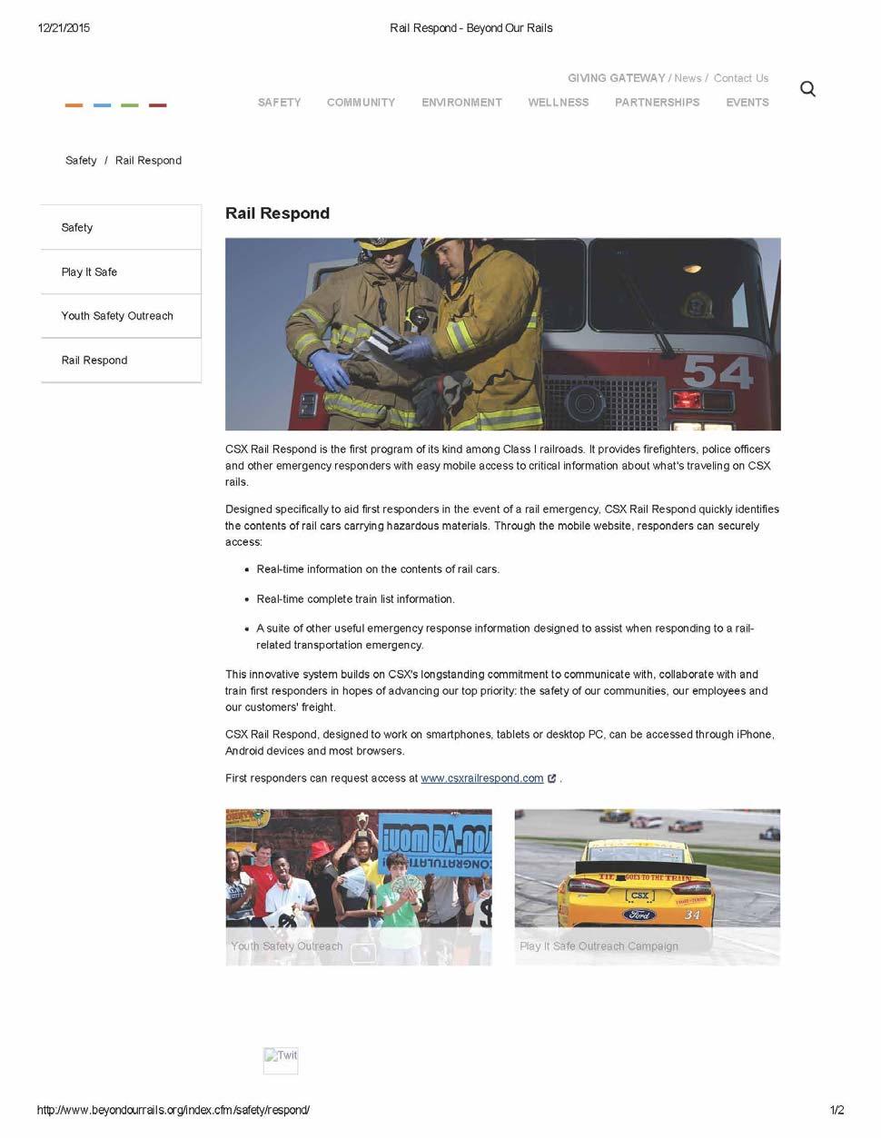
90 85
91 86
92 Appendix F-8. Considerations for Future SWPPs Following submittal of the 2016 Harpers Ferry Water Works Source Water Protection Plan (SWPP), the West Virginia Bureau for Public Health requested that the following factors or corrections be included in future iterations of the SWPP: A map depicting the Zone of Peripheral Concern for the Potomac River Intake (backup source) has been included in this submittal (Figure 7A), and should be featured in future iterations of the SWPP. 87
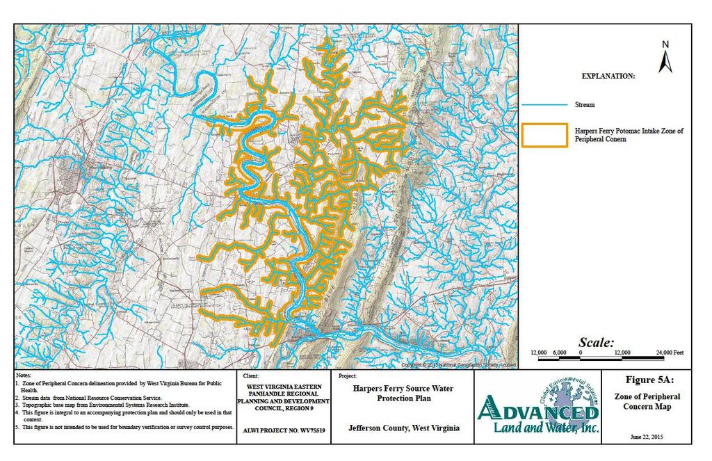
93 88
94 Harpers Ferry Water Works Public Outreach and Involvement Summary The Protection Team: Efforts to engage local stakeholders, government entities and specific members of the community in forming the Harpers Ferry Water Works (HFWW) Source Water Protection Team are listed below. 1. ALWI provided HFWW a recommended list of entities (including local stakeholders, government officials, etc.) to consider inviting to participate on the Protection Team. This list also contained contact information for each potential invitee. 2. On behalf of HFWW, ALWI sent a formal invitation to each invitee selected by HFWW from the above mentioned list, by mail and electronically ( ). 3. RSVPs were received by ALWI over the next few weeks, and reported to HFWW prior to the Protection Team Meeting, which was held on March 18, The system s Source Water Protection Plan (SWPP) documents which invitees responded, and which were willing to participate on the Protection Team. 4. The corresponding minutes for the March 18, 2016 Protection Team Meeting can be found in Appendix E-4 of the HFWW SWPP. The Public Workshop: Efforts to publicize the HFWW Source Water Protection Public Workshop are listed below. 1. A Press Release was developed and provided to both HFWW and the Eastern Panhandle Regional Planning & Development Council (Region 9). The press release was distributed to the local media and posted on the HFWW website, as well as the Region 9 website. The SWPP Report: Efforts to inform the public of the SWPP update and to receive comments and opinions on the content of the report are listed below. 1. ALWI created a SWPP Summary PowerPoint presentation for Region 9 to host on their website. This afforded the public an opportunity to view general SWPP information prior to the Draft SWPP being uploaded for public review and comment. 2. A public version of the SWPP Draft was posted on the Region 9 website for the public to opine on, prior to final submittal of the plan to WV BPH. At the close of the public comment period, ALWI discussed comments received with HFWW and updated the SWPP accordingly.
95
96
97
98
99

100 October 13, 2016 West Virginia Department of Health and Human Resources, Bureau for Public Health, Office of Environmental Health 350 Capitol Street, Room 313 Charleston, WV Attn: Source Water Protection Program Re: Protection Plan Comments Submitted electronically to: Dear Mr. Rodeheaver, The Source Water Protection Plans are a critical first step in the protection of our drinking water sources. These plans help to identify and prioritize potential drinking water contamination sources and help water utilities develop a plan to respond to a contamination event. Involving the public in the development of these plans is crucial part of the planning process. These hearings need to be advertised well in advance to give the public ample opportunity to attend. Overall, these plans are thorough, well-organized and well-designed. There is good information on the system that is easy to understand. Harpers Ferry SWPP Contingency Plan-It s not clear what the back-up power supply is, if there is one. Table 12, Generator capacity about what type of generator and how the system is set up is marked as confidential. A list of fuel providers is give, but then is says that generators are not in place. Harpers Ferry plans to upgrade the facility with back-up power generation-is there currently any back-up power generation capabilities? Early warning system-seems that all samples are collected right near the intake. While not required by the law, has Harpers Ferry considered sample collection or monitoring further upstream on Elk Run or the Potomac, to provide more warning of a contamination event? Contamination threats - The mapping provided in this version only shows previously identified PSSCs. Is there additional mapping that shows the BPH data? And the locally identified PSSCs? Charles Town SWPP Contingency Plan - Charles Town will request GPPs and Stormwater management plans from commercial and industrial facilities. Does this include all facilities within the SWPA? What will Charles Town do with this info? How will they reach out to facilities of concern directly? Should they also consider reviewing Spill Prevention Response Plans for ASTs?
Source Water Protection Plan BERKELEY COUNTY PSWD POTOMAC RIVER PLANT
 Source Water Protection Plan BERKELEY COUNTY PSWD POTOMAC RIVER PLANT PWSID WV3300218 BERKELEY COUNTY May 24, 2016 Prepared by: The Berkeley County Public Service Water District and Advanced Land and Water,
Safe Water Depends on Us.
 DRINKING WATER PROTECTION A Citizen s Guide to Getting Involved Safe Water Depends on Us. Learn What You Can Do. SAFE WATER FOR WEST VIRGINIA 1 WHERE DOES YOUR DRINKING WATER COME FROM? source water Source
Source Water Protection Plan Buckhannon Water Department
 Buckhannon Water Department PWSID WV3304902 Upshur County April 206 Prepared by: Tetra Tech, Inc. 803 Quarrier Street, Suite 400 Charleston, WV 2534 In cooperation with Buckhannon Water Department This
Supplemental Guide II-Delineations
 Supplemental Guide II-Delineations Contents Source Water Protection Area Delineation... 1 Delineation Criteria for Systems Using Groundwater Sources... 2 Time of Travel... 4 Flow Boundaries... 4 Delineation
State of West Virginia Source Water Assessment and Protection Program Source Water Assessment Report
 State of West Virginia Source Water Assessment and Protection Program Source Water Assessment Report Beckley Water Company Raleigh County PWSID: WV3304104 Prepared by: West Virginia Department of Health
Source Water Protection Plan
 Source Water Protection Plan Gassaway Water System PWSID WV3300406 Braxton County WVBPH Submittal Public Version June 2016 TABLE OF CONTENTS Table of Contents... i Acronyms... ii 1.0 Introduction... 1
SOURCE WATER PROTECTION PLAN IMPLEMENTATION FOR UTILITIES, WATERSHED OR OTHER COMMUNITY GROUPS
 SOURCE WATER PROTECTION PLAN IMPLEMENTATION FOR UTILITIES, WATERSHED OR OTHER COMMUNITY GROUPS 1 INTRODUCTION PURPOSE This guide will provide information to utilities and watershed groups about Source
Source Water Protection Plan Clarksburg Water Board
 Clarksburg Water Board PWSID 3301705 Harrison County May 2016 Prepared by: Tetra Tech, Inc. 803 Quarrier Street, Suite 400 Charleston, WV 25314 In cooperation with Clarksburg Water Board, Region VI Planning
SOURCE WATER PROTECTION PLAN
 SOURCE WATER PROTECTION PLAN JEFFERSON COUNTY PSD - GLEN HAVEN UTILITIES PWSID WV3301909 JEFFERSON COUNTY August 24, 2012 Prepared by: West Virginia Department of Health and Human Resources Bureau for
State of West Virginia Source Water Assessment and Protection Program Source Water Assessment Report
 State of West Virginia Source Water Assessment and Protection Program Source Water Assessment Report Capon Bridge Water Hampshire County PWSID: WV3301402 Prepared by: West Virginia Department of Health
Section 319 Incremental Project Proposal for Elks Run Watershed West Virginia Stream Code:WVP-1
 1 Section 319 Incremental Project Proposal for Elks Run Watershed West Virginia Stream Code:WVP-1 in the Potomac Direct Drains Watershed Jefferson County, WV 2010 Anticipated need for 319 funding $55,000
State of West Virginia Source Water Assessment and Protection Program Source Water Assessment Report
 State of West Virginia Source Water Assessment and Protection Program Source Water Assessment Report Supplemental Report Green Valley-Glenwood PSD (Glenwood) Mercer County PWSID WV3302849 Prepared by:
Source Water Assessment Program (SWAP) Report for Heath Elementary School
 Report for Heath Elementary School") Source Water Assessment Program (SWAP) Report for Heath Elementary School What is SWAP? The Source Water Assessment Program (SWAP), established under the federal Safe Drinking Water Act, requires every
Source Water Assessment Program (SWAP) Report for Heath Elementary School What is SWAP? The Source Water Assessment Program (SWAP), established under the federal Safe Drinking Water Act, requires every
State of West Virginia Source Water Assessment and Protection Program Source Water Assessment Report
 State of West Virginia Source Water Assessment and Protection Program Source Water Assessment Report Glen Rogers PSD Wyoming County PWSID: WV3305508 Prepared by: West Virginia Department of Health and
State of West Virginia Source Water Assessment and Protection Program Source Water Assessment Report
 State of West Virginia Source Water Assessment and Protection Program Source Water Assessment Report Windmill Gap Water System Mercer County PWSID: WV3302853 Prepared by: West Virginia Department of Health
Template. For Preparing a Source Water Assessment and Protection Plan. The. Fill-in-the-Blank Form
 Template For Preparing a Source Water Assessment and Plan The Fill-in-the-Blank Form Prepared for: West Virginia Department of Health and Human Resources Bureau for Public Health Office of Health Services
State of West Virginia Source Water Assessment and Protection Program Source Water Assessment Report
 State of West Virginia Source Water Assessment and Protection Program Source Water Assessment Report Page Kincaid PSD Fayette County PWSID: WV3301036 Prepared by: West Virginia Department of Health and
State of West Virginia Source Water Assessment and Protection Program Source Water Assessment Report
 State of West Virginia Source Water Assessment and Protection Program Source Water Assessment Report Anawalt Municipal Water McDowell County PWSID: WV3302416 Prepared by: West Virginia Department of Health
Part 2. SOURCE WATER PROTECTION: Developing a Plan that Works for YOU
 Part 2 SOURCE WATER PROTECTION: Developing a Plan that Works for YOU Mark Stephens, P.G. PA DEP North Central Region Office Williamsport m.stephens@state.pa.us SWP Quick Review What Is Source Water Protection?
State of West Virginia Source Water Assessment and Protection Program Source Water Assessment Report
 State of West Virginia Source Water Assessment and Protection Program Source Water Assessment Report Greenbrier County PSD #2 Greenbrier County PWSID: WV3301302 Prepared by: West Virginia Department of
State of West Virginia Source Water Assessment and Protection Program Source Water Assessment Report
 State of West Virginia Source Water Assessment and Protection Program Source Water Assessment Report Austin MHP Berkeley County PWSID: WV3300244 Prepared by: West Virginia Department of Health and Human
State of West Virginia Source Water Assessment and Protection Program Source Water Assessment Report
 State of West Virginia Source Water Assessment and Protection Program Source Water Assessment Report Bradshaw Water Works McDowell County PWSID: WV3302437 Prepared by: West Virginia Department of Health
SOURCE WATER ASSESSMENT SUMMARY BROCHURE
 SOURCE WATER ASSESSMENT SUMMARY BROCHURE MILL CITY WATER DEPARTMENT PWS # 4100520 WHAT IS A SOURCE WATER ASSESSMENT? The Source Water Assessment was recently completed by the Department of Environmental
State of West Virginia Source Water Assessment and Protection Program Source Water Assessment Report
 State of West Virginia Source Water Assessment and Protection Program Source Water Assessment Report Pierpoint PSD Wyoming County PWSID: WV3305536 Prepared by: West Virginia Department of Health and Human
Source Water Assessment Program (SWAP) Report for Rowe Elementary School
 Report for Rowe Elementary School") Source Water Assessment Program (SWAP) Report for Rowe Elementary School What is SWAP? The Source Water Assessment Program (SWAP), established under the federal Safe Drinking Water Act, requires every
Source Water Assessment Program (SWAP) Report for Rowe Elementary School What is SWAP? The Source Water Assessment Program (SWAP), established under the federal Safe Drinking Water Act, requires every
SOURCE WATER PROTECTION: Developing a Plan that Works for YOU. Lyn O Hare Spotts, Stevens & McCoy
 SOURCE WATER PROTECTION: Developing a Plan that Works for YOU Lyn O Hare Spotts, Stevens & McCoy SWP What Is Source Water Protection? Taking proactive measures to prevent the pollution of lakes, rivers,
State of West Virginia Source Water Assessment and Protection Program Source Water Assessment Report
 State of West Virginia Source Water Assessment and Protection Program Source Water Assessment Report Mason County PSD - Letart Mason County PWSID: WV3302713 Prepared by: West Virginia Department of Health
The Michigan Wellhead Protection Program Guide
 The Michigan Wellhead Protection Program Guide Michigan Department of Environmental Quality Drinking Water & Environmental Health Section February 2006 State of Michigan Jennifer Granholm, Governor Department
SOURCE WATER ASSESSMENT SUMMARY BROCHURE
 SOURCE WATER ASSESSMENT SUMMARY BROCHURE TILLER ELEMENTARY, SD #15 PWS # 4192139 WHAT IS A SOURCE WATER ASSESSMENT? The Source Water Assessment was recently completed by the Department of Environmental
State of West Virginia Source Water Assessment and Protection Program Source Water Assessment Report
 State of West Virginia Source Water Assessment and Protection Program Source Water Assessment Report Arbuckle PSD Fayette County PWSID: WV3301003 Prepared by: West Virginia Department of Health and Human
2 ROLES AND RESPONSIBILITIES
 2 ROLES AND RESPONSIBILITIES Overview Ground water protection within the NNEPA occurs through a coordinated effort between various NNEPA departments - the Air / Toxics department, Waste Regulatory & Compliance
State of West Virginia Source Water Assessment and Protection Program Source Water Assessment Report
 State of West Virginia Source Water Assessment and Protection Program Source Water Assessment Report Oakland PSD Hancock County PWSID: WV3301517 Prepared by: West Virginia Department of Health and Human
4 DETERMINATION OF WELLHEAD PROTECTION AREAS
 4 DETERMINATION OF WELLHEAD PROTECTION AREAS A wellhead protection area is defined as the surface and subsurface area surrounding a well, wellfield or spring that supplies a public water supply through
SOURCE WATER ASSESSMENT SUMMARY BROCHURE
 SOURCE WATER ASSESSMENT SUMMARY BROCHURE CITY OF OAKLAND PWS # 4100581 WHAT IS A SOURCE WATER ASSESSMENT? The Source Water Assessment was recently completed by the Department of Environmental Quality (DEQ)
PUTNAM COUNTY COMPREHENSIVE PLAN EXHIBIT DD INFRASTRUCTURE ELEMENT
 COMPREHENSIVE PLAN EXHIBIT DD D. Infrastructure Element (Sanitary Sewer, Potable Water, Solid Waste, Drainage and Natural Groundwater Aquifer Recharge) Goals, Objectives and Policies GOAL D.1: Putnam County
Goose Creek Watershed Assessment Summary October 2003
 Goose Creek Watershed Assessment Summary October 2003 The Goose Creek Watershed The Goose Creek watershed is 385 square miles, covering nearly half of Loudoun County and one-quarter of Fauquier County
State of West Virginia Source Water Assessment and Protection Program Source Water Assessment Report
 State of West Virginia Source Water Assessment and Protection Program Source Water Assessment Report Veterans Hospital Berkeley County PWSID: WV3300227 Prepared by: West Virginia Department of Health and
State of West Virginia Source Water Assessment and Protection Program Source Water Assessment Report
 State of West Virginia Source Water Assessment and Protection Program Source Water Assessment Report City of Wellsburg Brooke County PWSID: WV3300517 Prepared by: West Virginia Department of Health and
CITY OF MERCER ISLAND 2017 STORMWATER MANAGEMENT PROGRAM (SWMP) PLAN
 PLAN") CITY OF MERCER ISLAND 2017 STORMWATER MANAGEMENT PROGRAM (SWMP) PLAN May, 2017 CITY OF MERCER ISLAND 2017 S T O R M W A T E R M A N A G E M E N T P R O G R A M ( S W M P ) P L A N May 2017 City of Mercer
CITY OF MERCER ISLAND 2017 STORMWATER MANAGEMENT PROGRAM (SWMP) PLAN May, 2017 CITY OF MERCER ISLAND 2017 S T O R M W A T E R M A N A G E M E N T P R O G R A M ( S W M P ) P L A N May 2017 City of Mercer
State of West Virginia Source Water Assessment and Protection Program Source Water Assessment Report
 State of West Virginia Source Water Assessment and Protection Program Source Water Assessment Report Hundred Littleton PSD Wetzel County PWSID: WV3305202 Prepared by: West Virginia Department of Health
Drinking Water Source Protection General Information on Funding and Rating Projects
 Drinking Water Source Protection General Information on Funding and Rating Projects The FFY-2014 Funding Drinking Water Source Protection (DWSP) Letter of Interest (LOI) solicitation will be used to gather
SOURCE WATER ASSESSMENT SUMMARY BROCHURE
 SOURCE WATER ASSESSMENT SUMMARY BROCHURE USFS TILLER RANGER STATION PWS # 4101092 WHAT IS A SOURCE WATER ASSESSMENT? The Source Water Assessment was recently completed by the Department of Environmental
State of West Virginia Source Water Assessment and Protection Program Source Water Assessment Report
 State of West Virginia Source Water Assessment and Protection Program Source Water Assessment Report Groundwater Well Source Revised Report City of Belmont PWSID WV3303701 Pleasants County Prepared by:
The Lake Maumelle watershed
 Source Water Protection Central Arkansas: Programs & Practices Martin Maner, PE and Trevor Clements Implementing Adaptive Management in Central Arkansas Introduction The Lake Maumelle watershed in central
(this cover page left intentionally blank)
") 4. Siting the Well (this cover page left intentionally blank) 4. Siting the Well Chapter Table of Contents Chapter Table of Contents Chapter Description... 4 Regulatory Requirements Well Siting... 4 Relevant
4. Siting the Well (this cover page left intentionally blank) 4. Siting the Well Chapter Table of Contents Chapter Table of Contents Chapter Description... 4 Regulatory Requirements Well Siting... 4 Relevant
WELLHEAD PROTECTION PLAN FOR THE CITY OF NORTH MANKATO, MINNESOTA
 WELLHEAD PROTECTION PLAN FOR THE CITY OF NORTH MANKATO, MINNESOTA September 2017 Forward This document presents the wellhead protection (WHP) plan for the City of North Mankato that will help provide for
SOURCE WATER ASSESSMENT SUMMARY BROCHURE
 SOURCE WATER ASSESSMENT SUMMARY BROCHURE USFS WOLF CREEK JOB CORPS PWS # 4101095 WHAT IS A SOURCE WATER ASSESSMENT? The Source Water Assessment was recently completed by the Department of Environmental
CHAPTER 10 NATURAL GROUNDWATER AND AQUIFER RECHARGE ELEMENT
 CHAPTER 10 NATURAL GROUNDWATER AND AQUIFER RECHARGE ELEMENT Page 1 of 7 G:\Comp\Adopted Comprehensive Plans\15. Cylce 16-2 and 16-3\Elements not changed\ Groundwater & Aquifer A. OVERVIEW CHAPTER 10 NATURAL
CITY OF HARBOR SPRINGS WELLHEAD PROTECTION PROGRAM PLAN September 2004
 PAGE IV-1 IV. WELLHEAD PROTECTION AREA MANAGEMENT The goal of this element is to provide mechanisms which will prevent existing and potential sources of contamination from reaching the area s municipal
Work Group Accomplishments and Work Plans
 Annual Meeting November 20, 2014 Work Group Accomplishments and Work Plans Government Committee Held a meeting on Harmful Algal Blooms in May 2014. In addition to providing information to Partnership members,
INFRASTRUCTURE ELEMENT Goal, Objectives and Policies
 INFRASTRUCTURE ELEMENT Goal, Objectives and Policies City of Bartow Comprehensive Plan Adopted August 5, 1991 Amended August 2, 1993, Amended 1996 & 1999 Adopted Changes January 16, 2001, Amended April
SOURCE WATER ASSESSMENT SUMMARY BROCHURE
 SOURCE WATER ASSESSMENT SUMMARY BROCHURE CITY OF ROGUE PWS # 4100712 WHAT IS A SOURCE WATER ASSESSMENT? The Source Water Assessment was recently completed by the Department of Environmental Quality (DEQ)
SOURCE WATER ASSESSMENT SUMMARY BROCHURE
 SOURCE WATER ASSESSMENT SUMMARY BROCHURE STAYTON WATER SUPPLY PWS # 4100843 WHAT IS A SOURCE WATER ASSESSMENT? The Source Water Assessment was recently completed by the Department of Environmental Quality
SOURCE WATER ASSESSMENT SUMMARY BROCHURE
 SOURCE WATER ASSESSMENT SUMMARY BROCHURE PGE BEAVER GENERATING STATION PWS # 4105246 WHAT IS A SOURCE WATER ASSESSMENT? The Source Water Assessment was recently completed by the Department of Environmental
TITLE 9. ENVIRONMENT STATE WATER CONTROL BOARD
 November 2, 2005 TITLE 9. ENVIRONMENT STATE WATER CONTROL BOARD Title of Regulation: 9 VAC 25-780. Local and Regional Water Supply Planning (adding 9 VAC 25-780-10 through 9 VAC 25-780-190). Statutory
Source Water Assessment and Protection (SWAP) Report for Bellingham DPW Water & Sewer Division
 Report for Bellingham DPW Water & Sewer Division") Massachusetts Department of Environmental Protection Source Water Assessment and Protection (SWAP) Report for Bellingham DPW Water & Sewer Division What is SWAP? The Source Water Assessment Protection
Massachusetts Department of Environmental Protection Source Water Assessment and Protection (SWAP) Report for Bellingham DPW Water & Sewer Division What is SWAP? The Source Water Assessment Protection
LIVINGSTON COUNTY DRAIN COMMISSIONER Brian Jonckheere
 MICHIGAN DEPARTMENT OF ENVIRONMENTAL QUALITY GENERAL STORM WATER PERMIT MIG619000 ILLICIT DISCHARGE ELIMINATION PLAN FOR LIVINGSTON COUNTY DRAIN COMMISSIONER Brian Jonckheere Table of Contents Section
TRAVIS COUNTY WATER CONTROL AND IMPROVEMENT DISTRICT 17 STORMWATER MANAGEMENT PROGRAM TPDES PHASE II MS4 GENERAL PERMIT (TXR040000)
") TRAVIS COUNTY WATER CONTROL AND IMPROVEMENT DISTRICT 17 STORMWATER MANAGEMENT PROGRAM TPDES PHASE II MS4 GENERAL PERMIT (TXR040000) Prepared for Travis County Water Control and Improvement District 17
TRAVIS COUNTY WATER CONTROL AND IMPROVEMENT DISTRICT 17 STORMWATER MANAGEMENT PROGRAM TPDES PHASE II MS4 GENERAL PERMIT (TXR040000) Prepared for Travis County Water Control and Improvement District 17
City of Richmond Municipal Separate Storm Sewer System Annual Report
 City of Richmond Municipal Separate Storm Sewer System 2013-2014 Annual Report Introduction This annual report covers the reporting cycle July 1, 2013 through June 30, 2014 - Permit Year 1. The report
CITY OF HOYT LAKES, MINNESOTA SOURCE WATER ASSESSMENT
 CITY OF HOYT LAKES, MINNESOTA SOURCE WATER ASSESSMENT November 2002 Public Water Supplier ID 1690028 Facility Contact: Minnesota Department of Health Contact: Mr. Floyd Nelson, Supervisor Ms. Beth Kluthe
TABLE OF CONTENTS 8.0 CITY OF GUELPH...
 TABLE OF CONTENTS 8.0 CITY OF GUELPH... 8-1 8.1 Definitions... 8-1 8.2 City of Guelph Source Protection Plan Policies... 8-1 8.3 Transition Policies... 8-7 8.4 Policies Addressing Prescribed Drinking Water
City of Valdosta Land Development Regulations
 Chapter 324 Section 324-1 Environmental Planning Criteria Protection of Groundwater Recharge Areas (A) Purpose and Intent. Pursuant to O.C.G.A. 12-2-8 and the Georgia Department of Natural Resources (DNR),
Anne Arundel County Programmatic Two-Year Milestones January 2018 December 2019
 Anne Arundel County 2018 2019 Programmatic Two-Year Milestones January 2018 December 2019 (Note: New Milestones are highlighted in green) Target Urban Stormwater 12/2016 Implement the County s Watershed
The Village of Wellington NPDES Guidance/Reference Document
 The Village of Wellington NPDES Guidance/Reference Document The following Permit Compliance Guidance/Reference Document has been compiled to assist the copermittee in fulfilling the requirements of the
SOURCE WATER ASSESSMENT SUMMARY BROCHURE
 SOURCE WATER ASSESSMENT SUMMARY BROCHURE CITY OF ROSEBURG PWS # 4100720 WHAT IS A SOURCE WATER ASSESSMENT? The Source Water Assessment was recently completed by the Department of Environmental Quality
Infrastructure Element
 Infrastructure Element 1 2 3 4 5 6 7 8 9 10 11 12 13 14 15 16 17 18 19 20 21 22 23 24 25 26 27 28 29 30 31 32 33 34 35 36 37 38 39 40 41 42 43 44 45 INFRASTRUCTURE ELEMENT GOAL 1: To provide for environmentally
Protecting Water Sources
 DRAFT! For Personal Use Only. Protecting Water Sources June 2001 This booklet is part of a series of educational brochures and slide sets that focuses on various aspects of water source protection. The
Streamlines V2, n2 (May 1997) A Newsletter for North Carolina Water Supply Watershed Administrators
 A Newsletter for North Carolina Water Supply Watershed Administrators") Page 1 of 5 STREAMLINES A Newsletter for North Carolina Water Supply Watershed Administrators Volume 2, Number 2 May 1997 Non-Point Source (NPS) Pollution This issue of Streamlines provides basic information
Page 1 of 5 STREAMLINES A Newsletter for North Carolina Water Supply Watershed Administrators Volume 2, Number 2 May 1997 Non-Point Source (NPS) Pollution This issue of Streamlines provides basic information
Regional Stormwater Program 2013 Stormwater Management Plan
 Regional Stormwater Program 2013 Stormwater Management Plan This 2013 SWMP is an attachment to the 2012 Annual Report to the Department of Ecology for its Phase II NPDES Permit Prepared for: Asotin County
Source Water Assessment and Protection (SWAP) Report for Three Rivers Fire District
 Report for Three Rivers Fire District") Massachusetts Department of Environmental Protection Source Water Assessment and Protection (SWAP) Report for Three Rivers Fire District What is SWAP? The Source Water Assessment Protection (SWAP) program,
Massachusetts Department of Environmental Protection Source Water Assessment and Protection (SWAP) Report for Three Rivers Fire District What is SWAP? The Source Water Assessment Protection (SWAP) program,
SOURCE WATER ASSESSMENT SUMMARY BROCHURE
 SOURCE WATER ASSESSMENT SUMMARY BROCHURE CITY OF CAVE JUNCTION PWS # 4100971 WHAT IS A SOURCE WATER ASSESSMENT? The Source Water Assessment was recently completed by the Department of Environmental Quality
SECTION RISK-BASED ASSESSMENT AND CORRECTIVE ACTION FOR NON-UST PETROLEUM RELEASES
 SECTION.0500 - RISK-BASED ASSESSMENT AND CORRECTIVE ACTION FOR NON-UST PETROLEUM RELEASES 15A NCAC 02L.0501 PURPOSE AND SCOPE (a) The purpose of this Section is to establish procedures for risk-based assessment
Spill Response Procedures
 Spill Response Procedures [your municipality] Purpose: The purpose of this Standard Operating Procedure (SOP) is to provide guidance for the proper response and corrective actions to be followed in the
CHAPTER 10 DRINKING WATER
 CHAPTER 10 DRINKING WATER BOARD OF HEALTH ROLE AT A GLANCE Oversee the proper siting, operation, maintenance and monitoring of private wells. (If local regulations or bylaws are adopted granting the BOH
Notice of Intent for New or Renewal of General Permit for Discharges from Small MS4s Preamble
 Preamble PREAMBLE to NOTICE OF INTENT FOR NEW OR RENEWAL OF GENERAL PERMIT FOR DISCHARGES FROM SMALL MUNICIPAL SEPARATE STORM SEWER SYSTEMS - MS4S describing LAKE COUNTY S COUNTYWIDE APPROACH TO STORMWATER
Source Water Assessment and Protection (SWAP) Report for Hudson Water Supply
 Report for Hudson Water Supply") Massachusetts Department of Environmental Protection Source Water Assessment and Protection (SWAP) Report for Hudson Water Supply What is SWAP? The Source Water Assessment Program (SWAP), established under
Massachusetts Department of Environmental Protection Source Water Assessment and Protection (SWAP) Report for Hudson Water Supply What is SWAP? The Source Water Assessment Program (SWAP), established under
Source Water Assessment and Protection (SWAP) Report for Hinsdale Water Department
 Report for Hinsdale Water Department") Massachusetts Department of Environmental Protection Source Water Assessment and Protection (SWAP) Report for Hinsdale Water Department What is SWAP? The Source Water Assessment Program (SWAP), established
Massachusetts Department of Environmental Protection Source Water Assessment and Protection (SWAP) Report for Hinsdale Water Department What is SWAP? The Source Water Assessment Program (SWAP), established
CITY OF BLACK DIAMOND STORMWATER MANAGEMENT PROGRAM PLAN (SWMP PLAN) 2019 UPDATE
 2019 UPDATE") CITY OF BLACK DIAMOND STORMWATER MANAGEMENT PROGRAM PLAN (SWMP PLAN) 2019 UPDATE PREPARED BY Public Works Department CITY OF BLACK DIAMOND PO BOX 599 BLACK DIAMOND, WA 98010 (360) 886-5700 City of Black
CITY OF BLACK DIAMOND STORMWATER MANAGEMENT PROGRAM PLAN (SWMP PLAN) 2019 UPDATE PREPARED BY Public Works Department CITY OF BLACK DIAMOND PO BOX 599 BLACK DIAMOND, WA 98010 (360) 886-5700 City of Black
MARION COUNTY COMPREHENSIVE PLAN 2035
 GOALS, OBJECTIVES, AND POLICIES GOAL 1: Protect the function of the natural groundwater aquifer recharge areas of the County to ensure the availability of an adequate supply of quality groundwater and
4.05. Groundwater Program. Chapter 4 Section. Background. Follow-up to VFM Section 3.05, 2004 Annual Report. Ministry of the Environment
 Chapter 4 Section 4.05 Ministry of the Environment Groundwater Program Follow-up to VFM Section 3.05, 2004 Annual Report Chapter 4 Follow-up Section 4.05 Background Groundwater is defined as water located
Statewide Water Management Plan Association County Commissioners of Georgia May 2, 2008
 Statewide Water Management Plan Association County Commissioners of Georgia May 2, 2008 Introduction Coupled with Georgia s continued economic and population growth, the historicallysevere drought of 2007-08
OF CONTENTS 14.0 COUNTY OF BRANT...
 TABLE OF CONTENTS 14.0 COUNTY OF BRANT... 14-1 14.1 Definitions... 14-1 14.2 County Of Brant Source Protection Plan Policies... 14-2 14.3 Policies Addressing Prescribed Drinking Water Threats... 14-6 14.4
SCOPE OF WORK (Last amendment 9/18/08) Update: Signed agreement in hand Work to proceed March 15, 2009 June 30, 2010
 Update: Signed agreement in hand Work to proceed March 15, 2009 June 30, 2010") SCOPE OF WORK (Last amendment 9/18/08) Update: Signed agreement in hand Work to proceed March 15, 2009 June 30, 2010 TITLE: IDENTIFICATION OF ILLICIT DISCHARGES TO STORM DRAIN SYSTEM PROBLEM/NEED: The
SCOPE OF WORK (Last amendment 9/18/08) Update: Signed agreement in hand Work to proceed March 15, 2009 June 30, 2010 TITLE: IDENTIFICATION OF ILLICIT DISCHARGES TO STORM DRAIN SYSTEM PROBLEM/NEED: The
Source Water Assessment and Protection (SWAP) Report for Northampton Water Department
 Report for Northampton Water Department") Massachusetts Department of Environmental Protection Source Water Assessment and Protection (SWAP) Report for Northampton Water Department What is SWAP? The Source Water Assessment Program (SWAP), established
Massachusetts Department of Environmental Protection Source Water Assessment and Protection (SWAP) Report for Northampton Water Department What is SWAP? The Source Water Assessment Program (SWAP), established
Brown County Rural Development Site Analysis A Study by First District Association of Local Governments
 Brown County Rural Development Site Analysis A Study by First District Association of Local Governments Funded by the South Dakota Value Added Agriculture Subfund TABLE OF CONTENTS SUMMARY... 2 SECTION
ANNEX M: HAMILTON CREEK METROPOLITAN DISTRICT
 ANNEX M: HAMILTON CREEK METROPOLITAN DISTRICT M.1 Community Profile (HCMD) is a special district in Summit County. The District operates under the direction of a five person, elected Board of Directors.
USING THE SOURCE WATER PROTECTION OPERATIONAL GUIDE TO AWWA STANDARD G300
 USING THE SOURCE WATER PROTECTION OPERATIONAL GUIDE TO AWWA STANDARD G300 Sharon C. Long Wisconsin State Laboratory of Hygiene and University of Wisconsin - Madison Chi Ho Sham The Cadmus Group, Inc. Richard
INFRASTRUCTURE ELEMENT
 Goals, Objectives and Policies INFRASTRUCTURE ELEMENT SANITARY SEWER GOAL 4.A.1.: PROVIDE ADEQUATE CENTRAL SANITARY SEWAGE FACILITIES FOR RESIDENTIAL AND NON-RESIDENTIAL DEVELOPMENT AND REDEVELOPMENT IN
This is a digital document from the collections of the Wyoming Water Resources Data System (WRDS) Library.
 Library.") This is a digital document from the collections of the Wyoming Water Resources Data System (WRDS) Library. For additional information about this document and the document conversion process, please contact
This is a digital document from the collections of the Wyoming Water Resources Data System (WRDS) Library. For additional information about this document and the document conversion process, please contact
Regional Stormwater Management Plan for Troy Brook, Morris County, New Jersey
 Regional Stormwater Management Plan for Troy Brook, Morris County, New Jersey Executive Summary Troy Brook is in the Whippany River watershed, which has the first TMDL in the State of New Jersey, for fecal
Anne Arundel County Programmatic Two-Year Milestones January 2016 December 2017
 Anne Arundel County 2016 2017 Programmatic Two-Year Milestones January 2016 December 2017 (Note: New Milestones are highlighted in green) Target Urban Stormwater Implement the County s Watershed Protection
Primer introduction to watershed management Plan Process highlight the major steps of plan development Project types look at some examples of common
 1 Primer introduction to watershed management Plan Process highlight the major steps of plan development Project types look at some examples of common projects Plan Organization how to read the plan Next
STORMWATER POLLUTION PREVENTION PLAN
 STORMWATER POLLUTION PREVENTION PLAN TOWN OF WHITE BEAR, MINNESOTA Date: May 31, 2006 Project No. 13597.000 White Bear Township Storm Water Pollution Prevention Plan BMPS Following are the BMPs included
STATE COLLEGE BOROUGH WATER AUTHORITY LAND DEVELOPMENT LEGAL AUTHORITY. Robert Mix, Esq. Authority Solicitor Lee, Green & Reiter, Inc.
 STATE COLLEGE BOROUGH WATER AUTHORITY LAND DEVELOPMENT LEGAL AUTHORITY Robert Mix, Esq. Authority Solicitor Lee, Green & Reiter, Inc. STATE COLLEGE BOROUGH WATER AUTHORITY SYSTEM OVERVIEW Brian Heiser
SOURCE WATER ASSESSMENT PROJECT:
 SOURCE WATER ASSESSMENT PROJECT: An Assessment of Potential for Pollution of Surface Drinking Water Supply Sources Prepared by the Atlanta Regional Commission for Cherokee County Water & Sewer Authority
3. Engage stakeholders as active participants in developing effective, long-term water resource management objectives and strategies.
 Guidelines for Developing an Integrated Resource Plan Under the Delaware River Basin Commission Southeastern Pennsylvania Ground Water Protected Area Regulations September 25, 2002 A. Introduction Integrated
11.04 WELLHEAD PROTECTION ORDINANCE
 11.04 WELLHEAD PROTECTION ORDINANCE VILLAGE OF HILBERT CALUMET COUNTY, WISCONSIN SECTION 1 SHORT TITLE. This Ordinance shall be known and cited as the 'Wellhead Protection Ordinance" (hereafter Ordinance).
West Placer Groundwater Sustainability Agency Community Meeting February 16, 6 to 8 p.m. McBean Pavilion in Lincoln
 West Placer Groundwater Sustainability Agency Community Meeting February 16, 6 to 8 p.m. McBean Pavilion in Lincoln Community meeting overview The West Placer Groundwater Sustainability Agency held its
Lake Creek Watershed Management Plan Public Meeting. Arrowhead Lake May 3, :00 PM
 Lake Creek Watershed Management Plan Public Meeting Arrowhead Lake May 3, 2018 6:00 PM Agenda I. Welcome and Introductions II. III. IV. Watershed Basics Overview of Lake Creek Watershed Elements of a Successful
Town of Christiansburg 2017 DRINKING WATER QUALITY REPORT
 Town of Christiansburg 2017 DRINKING WATER QUALITY REPORT Table of Contents A Note from Town Manager Randy Wingfield................................... p. 1 Treatment Plant Information................................................