PENNSYLVANIA DEPARTMENT OF ENVIRONMENTAL PROTECTION VERIFICATION PROGRAM
|
|
|
- Grace Martin
- 6 years ago
- Views:
Transcription
1 PENNSYLVANIA DEPARTMENT OF ENVIRONMENTAL PROTECTION QAPP Addendum VERIFICATION PROGRAM March 4, 2016 Page 1
2 I. Contents Tables... 4 Figures... 5 II. Introduction... 6 III. Selection of Priority BMPs for Verification... 7 IV. Agricultural Practice Protocols... 8 Animal Waste Management Systems... 8 Significance of BMP... 8 Verification Procedures... 8 Verification Gaps Conservation Plans/SCWQA Significance of BMP Verification Procedures Verification Gaps Conservation Tillage Significance of BMP Verification Procedures Verification Gaps Cover Crops Significance of BMP Verification Procedures Verification Gaps Riparian Buffers Significance of BMP Verification Procedures Verification Gaps Land Retirement/Environmental Planting Significance of BMP Verification Procedures Verification Gaps Manure Transport Significance of BMP Verification Procedures Verification Gaps Page 2
3 Nutrient Management Significance of BMP Verification Procedures Verification Gaps Phytase Significance of BMP Verification Procedures Verification Gaps Wetland Restoration and Construction Significance of BMP Verification Procedures Verification Gaps V. Stormwater Management Protocols Erosion and Sediment Control Significance of BMP Verification Procedures Verification Gaps Post-Construction Stormwater BMPs (filtering and infiltration practices) Significance of BMP Verification Procedures Verification Gaps VI. Expanded Tree Canopy Protocol Significance of BMP Verification Procedures Verification Gaps VII. Stream Restoration Significance of BMP Verification Procedures Verification Gaps VIII. Legacy Sediment Removal and Aquatic Ecosystem Restoration of Natural Floodplains, Streams and Wetlands Significance of BMP Verification Procedures Verification Gaps IX. Wastewater Treatment Protocols Page 3
4 Significance of BMP Verification Procedures Verification Gaps X. Forest Harvesting Practices Protocols Significance of BMP Verification Procedures Verification Gaps XI. Next Steps Historical Data Cleanup Additional Data Collection and Verification Efforts New Commitment to Verify Growing Greener and Section 319 Projects Documenting Conservation Practices Through the Use of Remote Sensing A Pilot Study in the Potomac Watershed Selecting Additional Best Management Practices for Verification Verification Program Core Elements Statistical Approach for On-Site Verification Self Evaluations Protocols Data Management Professionals Conducting Verification Overall GAPs XII. References Tables Table 1. Verification Principles adopted by the Principals Staff Committee. 6 Table 2. Highest Priority BMPs for verification protocol development. 7 Table 3. Jurisdictional Verification Protocol Design Table: Animal Waste Management Systems. 16 Table 4. Examples of spot-check summaries from Pennsylvania NRCS year-end quality assurance summaries. 23 Table 5. Jurisdictional Verification Protocol Design Table: Conservation Plans and SCWQA. 26 Table 6. Jurisdictional Verification Protocol Design Table: Conservation Tillage. 30 Table 7. Summary data from 2015 pilot survey. 33 Table 8. Comparison of survey n values vs. calculated n values for various scenarios. 34 Table 9. Jurisdiction Verification Protocol Design Table: Cover Crops 37 Table 10. Statewide implementation goals and share of pollutant load reductions for riparian buffers. 39 Table 11. Buffer practices and associated programs. 39 Page 4
5 Table 12. Jurisdictional Verification Protocol Design Table: Riparian Buffers 42 Table 13. Programs involved in land retirement/environmental planting practices. 44 Table 14. Jurisdictional Verification Protocol Design Table: Land Retirement and Environmental Planting. 45 Table 15. Jurisdictional Verification Protocol Design Table: Manure Transport. 57 Table 16. Jurisdictional Verification Protocol Design Table: Nutrient Management. 64 Table 17. Statewide implementation goals and estimated share of pollutant load reductions for poultry and swine phytase. 66 Table 18. Site visits are required in the event of the following circumstances. NRCS Monitoring Schedule. 69 Table 19. Jurisdictional Verification Protocol Design Table: Wetland Restoration and Construction. 72 Table 20. Jurisdictional Verification Protocol Design Table: Urban Stormwater BMPs 79 Table 21. Jurisdictional Verification Protocol Design Table: Urban Stormwater BMPs. 90 Table 22. Jurisdictional Verification Protocol Design Table: Urban Tree Canopy 94 Table 23. Jurisdictional Verification Protocol Design Table: Stream Restoration. 99 Table 24. Jurisdictional Verification Protocol Design Table: Legacy Sediment Removal and Aquatic Ecosystem Restoration. 103 Table 25. Status of Wastewater Dischargers Cap loads, monitoring and remaining WLA capacity. 106 Table 26. Jurisdictional Verification Protocol Design Table: Wastewater Treatment. 112 Table 27. Jurisdictional Verification Protocol Design Table: Forest Harvesting Practices. 115 Table 28. Steps involved in reviewing imagery. 120 Figures Figure 1. Animal waste management system implementation in Pennsylvania Figure 2. Counties included in pilot cover crop survey Figure 3. Counties included in remote sensing pilot study, (green highlight) Page 5
6 II. Introduction The Chesapeake Bay Program has called for increased transparency and scientific rigor in the verification of the best management practices that are implemented as part of the states Watershed Implementation Plans and the Chesapeake Bay Total Maximum Daily Load (TMDL). To respond to this request, Strengthening Verification of Best Management Practices Implemented in the Chesapeake Bay Watershed: A Basinwide Framework, Report and Documentation from the Chesapeake Bay Program Water Quality Goal Implementation Team s BMP Verification Committee (Verification Framework) (Chesapeake Bay Program 2014), was developed. The Verification Framework is intended to serve as a guide for the states to document the methodology for verification of BMP installation, function, and continued effectiveness of practices over time. This Verification Framework provides the requirements for reporting and documentation of practice verification for the states to follow. Specific guidance is provided for each of the source sectors (agriculture, forestry, urban stormwater, wastewater, wetlands, and streams). Verification is formally defined by the Chesapeake Bay Program partners as the process through which agency partners ensure practices, treatments, and technologies resulting in reductions of nitrogen, phosphorus, and/or sediment pollutant loads are implemented and operating correctly. The Chesapeake Bay Program partnership s Principals Staff Committee formally adopted five verification principles in December 2012; these are described in Table 1. Table 1. Verification Principles adopted by the Principals Staff Committee. Principle Practice Reporting Scientific Rigor Public Confidence Adaptive Management Sector Equity Description Affirms that verification is required for practices, treatments and technologies reported for nitrogen, phosphorus and/or sediment pollutant load reduction credit through the Bay Program. This principle also outlines general expectations for BMP verification protocols. Asserts that BMP verification should assure effective implementation through scientifically rigorous and defensible, professionally established and accepted sampling, inspection and certification protocols. Recognizes that BMP verification shall allow for varying methods of data collection that balance scientific rigor with cost effectiveness and the significance of or priority placed upon the practice in achieving pollution reduction. Calls for BMP verification protocols to incorporate transparency in both the processes of verification and tracking and reporting of the underlying data. Recognizes that levels of transparency will vary depending upon source sector, acknowledging existing legal limitations and the need to respect individual confidentiality to ensure access to non-cost shared practice data. Recognizes that advancements in practice reporting and scientific rigor, as described above, are integral to assuring desired long-term outcomes while reducing the uncertainty found in natural systems and human behaviors. Calls for BMP verification protocols to recognize existing funding and allow for reasonable levels of flexibility in the allocation or targeting of funds. Calls for each jurisdiction s BMP verification program to strive to achieve equity in the measurement of functionality and effectiveness of implemented BMPs among and across the source sectors. Pennsylvania is committed to working with EPA and the Chesapeake Bay Program to continue to implement and strengthen BMP verification activities that balance verification work and limited resources. This QAPP addendum provides details on Pennsylvania s BMP Verification Program for the Chesapeake Bay. Page 6
7 III. Selection of Priority BMPs for Verification While it is the goal to verify implementation of all best management practices (BMPs) implemented within the Chesapeake Bay Watershed, resource constraints dictate that priorities be set to focus on those BMPs of greatest contribution to achieving Pennsylvania s pollutant load reduction goals. BMPs considered to be of the highest priority for developing verification procedures were those that are generally projected to contribute at least 5 percent of the load reduction to the state by Other BMPs, such as certain stormwater practices, were also selected to be addressed in this version of the QAPP addendum. Determinations of percent contribution were based on the watermelon charts provided by the Chesapeake Bay Program in Appendix P of the Verification Framework (Chesapeake Bay Program 2014). These charts provided the percent contribution from each BMP based on the state WIP. The resulting priority BMPs are listed in Table 2. In total, these BMPs account for 76, 64, and 84 percent, respectively, of the N, P, and sediment load reductions projected for 2025 under the Phase II WIP. Verification protocols for other BMPs with lower anticipated contributions to the overall load reductions will be developed but at a slower pace, given the reduced reliance on these practices to Pennsylvania s reduction strategy. Table 2. Highest Priority BMPs for verification protocol development. Sector Agriculture Agriculture Agriculture Agriculture Urban Agriculture Agriculture Agriculture Agriculture Urban Urban BMP Animal Waste Management Systems Conservation Plans/SCWQA Conservation Tillage Cover Crops Erosion and Sediment Control Forest Buffers Land Retirement/Environmental Planting Nutrient Management Poultry and Swine Phytase Urban Stormwater BMPs Wastewater Treatment/CSOs Page 7
8 IV. Agricultural Practice Protocols Animal Waste Management Systems Animal waste management systems (AWMSs) are practices designed for proper handling, storage, and use of wastes generated from AFOs. They include a means of collecting, scraping, or washing wastes and contaminated runoff from confinement areas into appropriate waste storage facilities (Chesapeake Bay Program Watershed Model Phase 5.3). Lagoons, ponds, or steel or concrete tanks are used for the treatment and/or storage of liquid wastes, and storage sheds or pits are common storage facilities for solid wastes. AWMS credits are applied against the manure acre land use within the Phase watershed model. For modeling purposes only each manure acre is defined as a pasture acre having the equivalent of 145 AEUs (animal equivalent units) of manure applied. The number of manure acres treated by an AWM system is defined as the AEUs that the system services divided by 145. For example, a dairy operation with 218 AEUs of livestock would be credited with 218/145 = 1.5 manure acres effectively treated. Significance of BMP Animal waste management systems accounts for 5.8, 15.7, and <1 percent, respectively, of the N, P, and sediment load reductions projected for 2025 under the Phase II WIP. The statewide implementation goal for 2025 is 1,251,150 AEUs. Animal waste management systems are considered a high priority for verification. Verification Procedures Programs Involved in Verification Animal waste management systems are implemented in a variety of ways in Pennsylvania (Figure 1). Current understanding is that most AWMSs are implemented with NRCS assistance (B in Figure 1), whereas implementation also occurs as part of Act 38 NMPs with (E in Figure 1) or without (A in Figure 1) NRCS assistance. These AWMSs are all implemented in accordance with NRCS practice standards and specifications. The overlap of Act 38 and NRCS-assisted practices (E) is unknown at this time. AWMSs that meet NRCS standards and specifications can also be implemented through other programs (e.g., Growing Greener, CBIG, section 319) with cost-share assistance or independently by operators without cost-share assistance (C in Figure 1). Finally, AWMSs can be implemented as Resource Improvement (RI) practices (D in Figure 1). Pennsylvania is currently assessing opportunities to verify AWMSs implemented under the multiple avenues depicted in Figure 1. Decisions have not yet been made regarding the specific approach or approaches that will be used. The following discussion describes each avenue for AWMS implementation while the Methods section summarizes existing and potential approaches to verification. Challenges that Pennsylvania faces in creating a robust program for verification of AWMSs are identified under Verification Gaps. Page 8
9 A Act 38 NMPs (Meet NRCS Standards/Specifications) 100% Initial Verification 100% Annual On-site Status Reviews E Overlap Unknown B NRCS-Funded (Meet NRCS Standards/Specifications) 100% Initial Verification 5% Annual Spot Checks C D Non-Act 38 and Non-NRCS With or Without Cost-Share (Meet NRCS Standards/Specifications)??% Initial Verification??% Annual Spot Checks Resource Improvement AWMS Practices??% Initial Verification??% Annual Spot Checks Figure 1. Animal waste management system implementation in Pennsylvania. Act 38 NMPs Manure management is included as Appendix 6 of nutrient management plans (NMPs). The structural BMPs outlined in the NMP are to be implemented within 3 years. AWMSs reported out of the Act 38 program are inspected and documented as part of annual On-Site Status Review Reports. USDA NRCS As described under Conservation Plans/SCWQA, initial certification of AWMS practices by NRCS follows methods specified in the General Manual, Title 450, Part 407 (GM-450, Part 407). All new AWMS practices for which NRCS provides assistance are inspected and verified by NRCS when installed. In addition, five percent of total practices installed or reported in the state are annually spot checked by NRCS, with a limit of 20 installations required per practice. Page 9
10 Comprehensive Nutrient Management Plans (CNMPs) developed for NRCS programs using the NRCS code 590 standard for PA follow the Act 38 NMP planning format, calculations, and style. Additionally, CAFO NMPs follow the same Act 38 NMP format, with some additional CAFO permit requirements added to the planning tools. CNMPs may involve implementation of a wide range of component practices associated with AWMSs, including: animal mortality facility (316); closure of waste impoundment (360); composting facility (317); constructed wetland (656); manure transfer (634); roof runoff structure (558); runoff management system (570); waste storage facility (313); waste treatment lagoon (359); waste utilization (633); and wastewater treatment strip (635). See Nutrient Management for additional details on CNMPs and NRCS practice code 590 plans. Pennsylvania reports the cost-shared AWMSs reported by NRCS but does not report the Conservation Technical Assistance (CTA) reported by NRCS. The Chesapeake Bay Program provides this information annually to Pennsylvania as two separate files as allowed under the USGS 1619 agreement with USDA. As noted above, Pennsylvania only collects and reports the NRCS-funded projects, but expects that the CTA records contain RIs (D in Figure 1) and state, private, and other funded projects that are reported and tracked through other programs (A and C in Figure 1). CTA project information cannot be reported at this time because additional information is needed to tag projects to specific programs and to avoid double-counting. Voluntary Efforts and Programs Other than Act 38 and USDA NRCS AWMSs meeting NRCS practice standards and specifications can also be implemented by operators with no cost-sharing or with cost-share funds under programs such as the Chesapeake Bay Implementation Grant program (CBIG), Pennsylvania s Growing Greener program, and the Clean Water Act Section 319 program (C in Figure 1). As stated in the Resource Improvement Practice Report (Chesapeake Bay Program Resource Improvement Practice Definitions and Verification Visual Indicators Report 2014), RIs are noncost-shared BMPs that are typically financed by the operator or other non-public entity or source and may or may not meet the practice standards associated with federal and state cost-share programs (D in Figure 1). RI practices may lack the contractual provisions of cost-shared BMPs as well as the corresponding implementation and maintenance oversight, but RIs contain all the critical elements for water quality resource improvement. RIs associated with AWMSs are dry waste storage structures (RI-1) and animal compost structures (RI-2). Method USDA NRCS The methods used by NRCS for initial and follow-up verification of practices installed with NRCS assistance are described in detail under Conservation Plans/SCWQA. These methods are applied to all new AWMS practices for which NRCS provides assistance, including NRCS Comprehensive NMP and Code 590 NMPs Act 38 NMPs Verification of NMPs at CAOs and CAFOs under Act 38 is described in detail under Nutrient Management. NMP approval includes an administrative review, an in-office review, and a technical on-site review. After plan approval, operators are required to keep implementation Page 10
11 records that may be reviewed as part of annual on-site status reviews. NMPs must be reviewed and updated/amended as needed at least every three years. Initial On-Site Reviews AWMSs are included in NMP verification because they play an important role in NMPs (Appendix 6). The nutrient management planner is required to conduct an on-site review of existing manure management practices on the agricultural operation. The purpose of this on-site review is to evaluate and document the adequacy of manure management areas, conditions, and practices to prevent surface or groundwater pollution from storm events up to and including a 25-year, 24-hour storm intensity and greater for swine, veal and poultry CAFOs. The following aspects of manure management need to be addressed during the initial on-site inspection of NMPs (see Nutrient Management for additional details regarding on-site inspections): Storm events up to and including a 25-year, 24-hour storm. Prevention of surface water (streams, lakes, and ponds) pollution. Prevention of groundwater pollution. Potential of stormwater commingled with manure and nutrients to directly run off into surface water or groundwater without adequate collection or treatment. In general, the on-site evaluation must consider all manure management practices related to manure handling, manure collection, manure storage and animal concentration area (ACA) management and runoff control. Specifically, three different categories of sites and practices need to be evaluated. These are outlined below. 1. Manure Handling & Storage The on-site evaluation must identify and evaluate the manure management practices related to the following manure storage areas: Manure storage facilities Permanent manure stacking and composting areas Animal mortality composting areas In-field manure stacking areas Emergency manure stacking areas Milking centers and facilities For liquid or semi-solid manure storages built after January 22, 2000, the storage must have a Professional Engineering certification to document the design and the integrity of the storage facility construction and that the facility meets the standards and specification of the Pennsylvania Soil and Water Technical Guide. The capacity of each manure storage structure or area must be adequate for the planned amount of manure (including wastewater, storm runoff water, and bedding) to be stored based on the expected application periods and management set forth in the NMP. Manure storage structures (made of concrete, timber or steel) must be designed and operated to include capacity to accommodate a 25-year, 24-hour storm and additional six inches of freeboard. Earthen manure storage ponds must be designed and operated to include capacity to accommodate a 25-year, 24-hour storm and additional one foot of freeboard. Each manure storage facility or site must be evaluated for evidence of current or past management that indicates that storage design capacity has been exceeded. A coating of manure, a debris line, or accumulated manure at an elevation higher than the levels described above are Page 11
12 all evidence of storage levels above design full. Each manure storage facility or area must be also evaluated for evidence of leaking or structural weaknesses that could compromise the ability of the storage to contain the stored manure. This should include an evaluation of both surface and subsurface losses. Each manure storage area must be evaluated for evidence of uncontrolled flow of stormwater into or across the area. In addition, each manure storage area must be evaluated for the existence of direct runoff or discharge of contaminated, inadequately treated water into surface water or groundwater. When these conditions are identified the evaluation must conclude that there are inadequate manure management practices and conditions and note BMPs needed to correct the deficiencies identified. 2. Animal Concentration Areas Animal concentration areas (ACAs) are barnyards, feedlots, loafing areas, exercise lots or other similar animal confinement areas that will not maintain a growing crop. Areas that are managed as pasture or other cropland are excluded from this designation. There may be smaller animal congregation areas in pastures that are non-vegetated. These would include: access lanes, watering areas, feeding areas or shade areas. These areas are not to be designated as animal concentration areas unless they cause a direct flow of nutrients to surface or groundwater. Therefore, all pasture areas on the operation need to be assessed as part of this on-site evaluation for the purpose of determining if these potential animal concentration areas do cause a direct flow of manure contaminated water to surface or groundwater. In general, the evaluation of the adequacy of ACA practices and conditions should consider the ability of the current practices and management to keep clean water clean and to collect, handle and treat contaminated runoff water before discharging into surface water or groundwater. ACAs must be located and sized appropriately to minimize the impact on surface and ground water. These areas should meet the appropriate criteria set forth in PA Technical Guide Standard 561, Heavy Use Area Protection, Standard 635, Wastewater Treatment Strips, Standard 393, Filter Strip, and others. 3. Silage & Feed Storage Areas These areas should be addressed in the NMP only if there is observable direct runoff of leachate or feed-laden runoff from these areas into surface or groundwater. These areas include: Upright silos Bunk or trench silos Ag bag stacking areas Feed or commodity storage areas Feed mixing areas 4. Additional CAFO Requirements CAFOs have additional requirements including covering manure within 15 days if stacked on the CAFO s application fields and maintaining useable space and capacity in the manure storage to sufficiently manage manure over the winter. Annual On-Site Status Reviews Page 12
13 See Nutrient Management for details on annual on-site status reviews. Reviewers record their onsite status review findings on the annual on-site review form which is included as Attachment 1 under Nutrient Management. Items of interest on the form pertaining to AWMS are shown in the following text box. 1. Nutrient Management Plan Implementation a. Is the operation current with its required plan review deadline? b. Are actual animal numbers consistent with the plan? c. Acreage receiving manure application g. Are installed BMPs being maintained? k. Are all Critical Runoff Problem Areas (CRPAs) addressed? n. Is emergency stacking required in the plan? If yes, is the site identified on plan maps? o. Are required in-field stacking procedures implemented? If yes, are site(s) identified on plan maps? If yes, are site(s) appropriate? Is manure applied within 120 days (CAFOs 15 days) or covered? 3. Manure Storage Information (where applicable) Note: Although they may not be Act 38 violations, No answers in this section require remedial action. a. Storage type and size: b. Is perimeter fence and warning signage in place/maintained? c. Is the structure free of significant cracks or structural damage? d. Are embankments free of manure saturated areas (seepage)? e. Are interior/exterior slopes free of holes, trees or erosion? f. Has storage been certified by a Professional Engineer? g. Is Emergency Response Plan available on the operation? 4. Animal Concentration Areas (ACAs) a. Are there ACAs on the operation (farmstead or pasture)? b. Is surface water adequately protected from runoff? c. Is erosion properly controlled at stream access point? d. Is manure collected and handled appropriately? e. Is animal access to stream properly controlled? f. Are pastures free of ACAs where runoff is reaching a stream? Inspector Notes: Are there violations of Act 38 regulations? If yes, specific violations (indicate section number and letter above): Are corrective actions needed? If yes, set approximate re-inspection date: Further action required (indicate section number and letter from above): Page 13
14 Voluntary Efforts and Programs Other than Act 38 and USDA NRCS Cost-Shared Practices At a minimum, practices implemented under the Growing Greener Program, CBIG, and Section 319 program are verified when initially installed. Non-Cost-Shared Practices Methods for verification of non-cost-shared practices in group C and RIs in group D of Figure 1 are currently under consideration. Group C practices meet NRCS definitions and standards. Methods to verify both RIs and non-cost-shared practices are described in Chesapeake Bay Program Resource Improvement Practice Definitions and Verification Visual Indicators Report (August 2014). Pennsylvania will fully consider recommendations in the Resource Improvement Practice Report as it develops methods for verification of these practices, including jurisdictional checklist requirements, re-verification intervals (e.g., 5 years for RI-1 and RI-2), and supporting data and documentation. Voluntary Online Survey The Pennsylvania Association of Conservation Districts (PACD) initiated in October 2015 an online survey that allows farmers to report voluntarily on conservation plans and practices they have completed as part of manure management plans (see Nutrient Management for details on manure management plans). Ten percent of the respondents, chosen at random, will have their data verified by their local conservation district. This tool may be useful in identifying practices in groups C and D of Figure 1, but it is too early to determine its role in the overall verification strategy for AWMSs. NRCS Pilot Aerial Survey The NRCS pilot aerial survey (see Documenting Conservation Practices Through the Use of Remote Sensing A Pilot Study in the Potomac Watershed) provides another mechanism for verification of AWMSs. Results of the pilot survey should provide clear indication of the role this tool could play in the overall verification effort. Potential applications include helping define the overlap between Act 38 and NRCS programs (E in Figure 1), as well as identifying practices that may fall within groups C and D of Figure 1. AWMS practices included in the pilot survey are: a) Animal Waste Storage, 313 b) Waste Treatment, 629 c) Waste Treatment Lagoon, 359 d) Animal Mortality Facility, 316 e) Animal Composting Facility, 317 Page 14
15 Verification Teams Staffing See Nutrient Management for staffing associated with Act 38. See Conservation Plans/SCWQA for information on NRCS practices, the Growing Greener Program, and Section 319 program. The Resource Improvement Practice Report specifies that any trained and/or certified technical field staff person that has the required knowledge and skills to determine if the practice meets the applicable RI definition and verification indicators may conduct the RI practice review. In addition, jurisdictions will have final oversight and will be the certifying entity of all information that is provided and approved for entry into the CBP NEIEN reporting system. Pennsylvania will adhere to these requirements as it develops its verification approach for RIs. Qualifications, Training, and Certification See Nutrient Management for qualifications, training, and certification requirements associated with Act 38. See Conservation Plans/SCWQA for information on NRCS practices, the Growing Greener Program, and Section 319 program. Unique qualifications, training, and certification for individuals verifying practices in groups C (non-cost-shared) and D in figure 1 have not yet been determined. Data Collection and Entry See Nutrient Management for additional details on Act 38. See Conservation Plans/SCWQA for information on NRCS practices, the Growing Greener Program, and Section 319 program. Procedures are currently not in place for handling data collected on practices in groups C (noncost-shared) and D in Figure 1. Independent Verification of Data See Nutrient Management for information associated with Act 38. See Conservation Plans/SCWQA for information on NRCS practices, the Growing Greener Program, and Section 319 program. Procedures are currently not in place for independently verifying data collected on practices in groups C (non-cost-shared) and D in Figure 1. Validation of External Data See Nutrient Management for information associated with Act 38. See Conservation Plans/SCWQA for information on NRCS practices, the Growing Greener Program, and Section 319 program. Procedures are currently not in place for handling data collected on practices in groups C and D in Figure 1. Addressing Historical Data and Double Counting Figure 1 illustrates the potential for double counting of AWMSs. Pennsylvania currently has no mechanism to distinguish between AWMSs implemented as part of Act 38 NMPs with and without (A in Figure 1) NRCS funding. Potential double counting is represented by the overlap (E). In addition, specific procedures are not yet in place for uniquely identifying practices implemented in groups C and D of Figure 1. Pennsylvania will develop procedures to prevent double counting as it develops an overall strategy for verifying AWMSs. See Nutrient Management for additional details associated with Act 38. See Conservation Plans/SCWQA for information on NRCS practices. Summary A snapshot summary of verification procedures for AWMSs related to Act 38 NMPs is provided in Table 3. Page 15
16 Table 3. Jurisdictional Verification Protocol Design Table: Animal Waste Management Systems. Verification Element BMP or Group Geographic Scope A. WIP Priority High B. Data Grouping Agriculture C. BMP Type Structural and Management D. Initial Inspection Method Frequency Who Inspects Documentation E. Follow-Up Check Follow-Up Inspection Statistical Sub- Sample Response if Problem Description Animal Waste Management System All counties within the Chesapeake Bay Watershed Act 38 Manual guides development of NMPs and assessment of manure management practices and facilities. NRCS: on-site certification. DEP: On-site verification conducted by local grant administrators. Non-cost-shared and RIs: Methods to be developed. Act 38 and NRCS: At plan approval and at installation if installed post plan approval. DEP: At installation. Non-cost-shared and RIs: To be determined. Act 38: Plans for CAOs, CAFOs, and VAOs are reviewed on site by certified specialists and approved by the SCC or delegated CDs. NRCS: Technical Specialist, or a TSP. DEP: Regional Water Quality Program Staff. Private Sector Engineers and Qualified Agricultural Experts. Local Project Grant Administrators. Non-cost-shared and RIs: To be determined. Act 38: Farmer records are kept on site and reviewed by the SCC or delegated CDs during the annual review (Attachment 1 of Nutrient Management). Important data such as animal types, animal numbers, nutrients applied, crop yields, manure exported or imported, installation or maintenance of BMPs such as manure management facilities, etc. are recorded. NRCS: Immediate reports to District Conservationist and inclusion of a summary of completed spot checks in the year-end Quality Assurance Report. DEP: Sign-off on final project reports. Private Sector Engineers and Qualified Agricultural Experts: As-built drawings and sign offs. Local Project Grant Administrators: Final project reports. Non-cost-shared and RIs: To be determined. Act 38: Annual on-site status reviews. NRCS: On-site. Non-cost-shared and RIs: To be determined. Act 38: No. DEP data on annual and quarterly activities is collected to supplement the initial NMP information. NMPs for CAOs and CAFOs are inspected yearly, on site. VAO are inspected at least once every 3 years. NRCS: 5% follow-up on-site inspections. Non-cost-shared and RIs: To be determined. Act 38: Plan updated or amendments are required if the AWMS is not sufficient to properly implement the plan as initially approved. The regulations and law spell out 10 specific items that would trigger a plan amendment. Plan amendments are handled similar to a new plan submission. If non-compliant with Act 38 requirements including the proper storage and handling of manure, follow-up on-site status reviews are scheduled with the operator in order to bring the operation back into compliance, with enforcement as the final step if compliance cannot be obtained. If the AWMS called for in the approved plan is not brought back into compliance, the AWMS practice should be removed from the NEIEN report. NRCS: If a practice does not meet specifications, the program participant and the TSP will be notified in writing of the deficiencies and corrective actions needed. A reasonable time period will be specified for the corrective action needed. For TSP assisted practices, failure to correct the deficiency within the specified time period may trigger the TSP decertification process by the State Conservationist. When corrective measures have been taken, a final check is to be made and the case closed. If corrective work is not done, the agency providing cost sharing is to be given the information and take further action in accordance with program regulations. If the practice is not existent or deemed non-functional, the AWMS practice should be removed from the NEIEN report. Non-cost-shared and RIs: If the AWMS practice is deemed not to exist when inspection takes place, the practice will be removed from the NEIEN report. If the practice is deemed not to function as designed, either the operator will be provided assistance to increase the functionality of the AWMS or the practice will be downgraded or removed from the NEIEN report. Page 16
17 Verification Element Description F. Lifespan/Sunset Act 38: Varies. NMPs are for 3 years unless an end date is provided prior to that time frame. AWMS practices are part of NMP follow-up inspections and will continue to be inspected as long as the operation continues to be required to implement a NMP. AWMSs have a credit lifespan of 15 years, while barnyard runoff control and lagoon covers have a lifespan of 10 years each. NRCS: Checks practices throughout contract lifespan. DEP: Local Grant Administrators check practices throughout the project lifespan for funded practices. Non-cost-shared and RIs: Varies. Non-cost shared practices may still meet NRCS standards and specifications, therefore the minimum practice lifespan would be the same as what has been identified above. RIs would have the credit duration or lifespan as identified by the CBP. G. Data QA, Recording & Act 38: NMP data are recorded in a DEP database when initially certified or amended. Trained Reporting staff enter the data to the DEP database. NRCS: Immediate reports to District Conservationist and inclusion of a summary of completed spot checks in the year-end Quality Assurance Report. Data from NRCS/FSA are assumed accurate by DEP. Double-counting is addressed based on funding source information. DEP: Local Project Administrators report BMPs installed in their grant project final reports. This final report information is submitted to the DEP regional office and the Grants Center for the recording of grant program accomplishments. Non-cost-shared and RIs: To be determined. Verification Gaps AWMSs can be implemented through multiple pathways as illustrated in Figure 1. Pennsylvania currently has a procedure for verifying AWMSs implemented as part of Act 38 NMPs, but coordination with other programs will be needed to capture this information. NRCS procedures verify all new installations and perform spot checks on 5 percent of total practices they install. However, the degree to which AWMSs implemented under Act 38 NMPs receive NRCS funding is not known. Additional dialogue is needed with federal agencies. Projects implemented using DEP provided funds are well verified at implementation time but have not been not consistently tracked by DEP staff after that time. To help address this, DEP is making a new commitment to expand verification of projects funded through the Growing Greener and Section 319 programs. Additional details are contained in the Next Steps section of this document. There are currently no procedures in place to verify RIs or practices meeting NRCS standards and specifications that were installed voluntarily without cost-share funds. The Department has a goal of developing procedures for verifying RIs and non-cost shared practices by July, 2017 and implementing those procedures by January, The Department will plan to utilize the guidance found in the CBP Resource Improvement Practice Definitions and Verification Indicators Report (July 2015, v. 5) to inform our procedures for verifying RI practices. Verification of BMPs implemented under the Growing Greener Program, CBIG, and the section 319 program needs to be coordinated with Act 38 and NRCS verification efforts. The NRCS pilot aerial survey and voluntary online survey for manure management plans are two efforts that may help fill existing verification gaps, but greater coordination with NRCS will be needed to address the major gap in quantifying the overlap between AWMS implementation under the Act 38 and NRCS programs. Integration of verification efforts associated with all groups shown in Figure 1 will be needed to ensure that AWMS implementation is fully credited and fully verified with no double counting. Page 17
18 A key element of this will be finding a suitable approach for obtaining BMP details within privacy constraints. This will require greater collaboration with NRCS. Page 18
19 Conservation Plans/SCWQA Soil conservation and water quality plans (SCWQA or conservation plans) are a combination of agronomic, management and engineered practices that protect and improve soil productivity and water quality, and are designed to prevent deterioration of natural resources on all or part of a farm (Chesapeake Bay Program Watershed Model Phase 5.3). The practices help to control erosion and nutrient runoff by modifying cultural or structural practices. Cultural practices can change from year to year and include changes to crop rotations. The practices do not include reduction credits to certain cultural practice changes on crop or hay land, such as conservation tillage or cover crop practices which are credited as individual BMPs. However, cultural practice changes are reflected in pastureland reduction efficiencies. Structural components consisting of longer term conservation measures included in the Field and Pasture Erosion Control Practices include the U.S. Department of Agriculture (USDA) Natural Resources Conservation Service (NRCS) conservation practices listed below. Note that credit cannot be taken for each practice implemented under a farm erosion and sediment plan or an NRCS Conservation Plan; the suite of practices listed in the plan are prescribed to meet a USDA-NRCS RUSLE2 prediction of soil losses at or below the soil loss tolerance value (T) for the accredited land acreage. Applicable NRCS codes Access Road (560) Alley Cropping (311) Animal Trails and Walkways (575) Conservation Cover (327) Conservation Crop Rotation (328) Contour Buffer Strips (332) Contour Farming (330) Critical Area Planting (342) Diversion (362) Field Border (386) Filter Strip (393) Grade Stabilization Structure (410) Grassed Waterway (312) Lined Waterway or Outlet (468) Residue Management, Seasonal (344) Rock Barrier (555) Row Arrangement (557) Sediment Basin (350) Strip cropping (585) Structure for Water Control (587) Terrace (600) Underground Outlet (620) Water and Sediment Control Basin (638) Windbreak/Shelterbelt Establishment (380) Page 19
20 Many conservation practices are available to address soil movement, transport, and loss from agricultural fields. The practices used are site-specific based on site conditions, landowner operation, and land use. Significance of BMP Conservations plans account for 2.4, 4.1, and 6.7 percent, respectively, of the N, P, and sediment load reductions projected for 2025 under the Phase II WIP. The implementation goal for 2025 is 2,908,925 acres. Conservation plans are considered a high priority for verification. Verification Procedures Programs Involved in Verification Conservation plans are reported from a suite of practices employed by NRCS in implementing BMPs at agricultural operations. Examples of these practices include contour farming, diversions, hedgerow planting, irrigation systems, and terraces among many others. Data for reporting this practice is primarily received from NRCS or the Farm Services Agency (FSA) of USDA. A small number of plans (4 records covering 6,500 acres in 2014, for example) were reported from Pennsylvania s Growing Greener Program. Lesser quantities of the conservation plan sub-practices are reported from the 319 and Nutrient Management Act Programs, which do not officially report plans but BMPs that map into the conservation plan BMP within Scenario Builder. Method Initial certification and quality assurance spot checking of practices installed with NRCS assistance follows methods specified in the General Manual, Title 450, Part 407 (GM-450, Part 407). Subpart A addresses policy and Subpart B addresses documentation and certification of practices. Spot checking procedures are contained in Subpart C. Spot checking procedures assure the quality of all certified practices, whether performed by NRCS employees, qualified contractors, other qualified individuals, or Technical Service Providers (TSPs). The State quality assurance plan should identify field offices, counties and practices to be spot checked during the year. Field Offices: The General Manual specifies that conservation practice installations certified by NRCS employees must be spot checked at least every third year. In Pennsylvania NRCS has 46 field offices serving all 67 counties and organized into 3 administrative areas. These administrative areas check one-third of the county offices each year, so each office is checked every three years as required. This includes a spot check on the work of each employee in the county once every three years. Certified Practices: All certified practices are subject to spot checking on a fiscal year basis. Practices are spot checked as soon after completion as practical. However, some vegetative and management practices can be spot checked only during certain seasons. Pennsylvania NRCS has over 130 practices to check, each of which is classified by its relative hazardous risk to human life and property. For example, failure of an animal waste storage structure is a greater risk than failure of a cover crop. The set of 130 practices includes all practices implemented in Pennsylvania with technical assistance from NRCS and is therefore the complete set of NRCS practices contained in the state s WIP. Page 20
21 Each year, a minimum of five percent of total practices installed or reported in the state are spot checked. When a practice exceeds 400 occurrences in one given year, only 20 installations of that practice need to be checked. Practices occur on a field land unit scale so any one farm typically has many occurrences of a management practice, and several of vegetative or structurally practices. No more than 3-5 low-risk practice installations need to be checked per field office or county. It should be noted that, for example, there will likely not be 400 animal waste management storage facilities implemented in a single year, so the cap of 20 installations per year will not be reached for this high risk and other practices with fewer than 400 installations. In addition, while NRCS quality assurance reviewers perform sufficient spot checks in accordance with minimum General Manual requirements, they generally obtain a large enough sample to be confident with a review that there either is or is not a problem with specific installations or installations for a specific practice type within the counties served by the field office. When selecting the installation to be spot checked, NRCS must first determine the kind and number of practices installed in the fiscal year from field office records. In choosing which practices to spot check, State Conservationists (STCs) are directed to prioritize the spot checking of conservation practices that pose a greater risk to: life, property, and the environment; practices where a high percentage of annual cost-share funds were used; and practices with a high installation cost compared to other practices. STCs and Directors are required to develop a procedure to set priorities for conservation practices to be spot checked. High- risk practices may be spot checked at a higher rate than low-risk practices. In addition, the person performing the spot checking is directed to select random samples of the technical work of as many members of the staff as practicable. Spot checks are to be distributed among various practices applied during the year, and each type practice should be spot checked at least every 3 years. If errors or deficiencies are found, NRCS is required to check additional installations until a true picture of the quality of the work is obtained. All practices for which NRCS is technically responsible on all farms that NRCS employees own or have an interest in are to be spot checked These checks, as well as those checks made during State quality reviews, are counted as part of the spot-check requirement. Qualified Contractors and Other Qualified Individuals (Not TSPs): NRCS spot checks 5 percent of contractor certifications. Complete construction checks and checks of the documentation furnished by the contractor, including approved drawings and specifications, should be made on one or more jobs installed by each contractor during the year. The check notes must be recorded and filed. Conservation Practices or Practice Components Completed by TSPs: NRCS performs spot checks of TSP-completed conservation practices or components using an annual list of practices completed by each TSP in each State or area in which TSPs have completed work. NRCS spot checks at least the first two plans or practices completed by a certified TSP. In addition, spot checks are performed for at least 5 percent of implemented conservation plans and practices annually. The sample of an individual TSP s work that is spot checked must be a representative cross section by geographic area, size of projects, and complexity of projects. The person performing the spot check may expand the sample as necessary to determine the scope of any problems or deficiencies. The expanded sample may be extended to include installations completed in previous years. Page 21
22 Practice Assessments Spot checking the quality of practices installed assures compliance with NRCS practice standards and specifications and applicable regulatory requirements. Assessments, called spot checking quality reviews by NRCS, verify the accuracy and adequacy of the design, quality of installation, accuracy of measurements and computations, adequacy of supporting records, and the need and practicability of the practice, including its role in a resource management system. The checker should make enough notations to substantiate checking of the installation and the supporting data. For each practice, specific check data items are identified. See the practice Statements of Work (SOW) for items required to be checked. The checker is to record the observations and measurements made in determining accuracy of the original document. Notes and records of spot checks are to be filed at the field office that helped install the practice. Reporting Spot-checking reports are created as soon as the spot checking is completed. Reports are addressed to the appropriate line officer with a copy to the NRCS District Conservationist. Reports are to describe results of the review including commendable work, deficiencies, and suggestions for innovative technology development, plus the following information: Name and extent of each practice checked. Participant's name and location of property on which a practice was checked. Statement that the practice checked met specifications and the amount certified is correct. Program under which the practice was applied. Adequacy of supporting data. Other comments as needed. If the spot check reveals deficiencies such as a practice that fails to meet specifications, lack of supporting data, or errors in quantities, the report is to include: o Details of how the practice failed to meet specifications or lacked adequate supporting data, or both. o Recommendations for correcting deficiencies. o Suggested training or other action to help prevent recurrence of deficiencies. If the spot check reveals commendable quality work, this should also be documented. NRCS is also required to report on spot checks of qualified contractors and other qualified individuals who are not TSPs. Deficiencies are to be reported as part of the State quality assurance summary. In addition to notifying the participant or producer, the field office staff must work with the contractor to satisfactorily resolve the issues. A satisfactory resolution will range from correcting a simple error or misunderstanding to not accepting future documentation until such documentation is submitted in an accurate, acceptable manner. Upon request from a contractor, the field office staff will furnish in writing to that contractor information related to acceptance of his or her work by NRCS. The letter will be tailored to identify the acceptance of construction and documentation for the individual contractor. Reports on spot checks of TSPs are to be sent to the STC and the appropriate line officers within 15 working days of completing the spot check of the TSP s work. If the spot check identifies deficiencies, the person performing the spot check is required to notify the district Page 22
23 conservationist and the State TSP coordinator of the findings and any recommendations for corrective action. The State TSP coordinator will determine if further management or administrative actions will be taken in accordance with TSP policy. NRCS is required to prepare a summary of completed spot checks and incorporate it into the year-end quality assurance summary. The examples in Table 4 from Pennsylvania NRCS reports in 2013 and 2014 illustrate these spot-check summaries. While a 5 percent verification rate and the cap of 20 installations per year creates the potential for a shortfall with regard to the 10 percent rate called for in EPA's verification guidance, it should be noted that other factors (e.g., patterns noted for specific practices or areas) may lead to an increase in the percentage rate. For example, it can be seen in Table 4 that in 2013 fence, critical area planting, and brush management practices were spot checked at rates of 17, 30, and 56 percent, respectively, far exceeding the 10 percent requirement. In addition, the cap of 20 installations for prescribed grazing, waste storage facility, and grassed waterway were exceeded in Spot-checking rates for these three practices were 5, 13, and 7 percent respectively. Nutrient management was inspected at the minimum rate of 5 percent in 2014, but because all Act 38 NMPs are reviewed each year by the districts (see Nutrient Management) there is no gap in verification coverage for this practice. Act 38 inspections also cover a range of structural and management practices that are complementary to nutrient management. Table 4. Examples of spot-check summaries from Pennsylvania NRCS year-end quality assurance summaries. Example Practice applied Year West Area Applied NE Area Applied SE Area Applied Total Applied Statewide Total Checked 5% Target Check # Practices with deficiencies 314 Brush Management 342 Critical Area Planting 382 Fence Nutrient Management 528 Prescribed Grazing 313 Waste Storage Facility 412 Grassed Waterway Follow-Up Prompt and thorough follow-up of spot-checking reports is essential. If the checker questions need and practicability, he or she is to discuss the findings and opinions with the appropriate line officer. STC and Directors will ensure that line officers report annually the status of spot checking to the STC within 90 days after the end of the spot-check year. Deficiencies are to be described in detail, and a follow-up report is required each 60 days until all follow-up action has been completed. If performance of the practice has been certified, and significant errors in quantities certified are found, the office responsible and the participant are to be informed immediately. If a practice Page 23
24 does not meet specifications, the district conservationist is to take action immediately to assist the participant in making necessary modifications to meet specifications. For spot checks of TSP work, the program participant and the TSP will be notified in writing of the deficiencies and corrective actions needed. A reasonable time period will be specified for the corrective action needed. For TSP assisted practices, failure to correct the deficiency within the specified time period may trigger the TSP decertification process by the STC. When corrective measures have been taken, a final check is to be made and the case closed. If corrective work is not done, the agency providing cost sharing is to be given the information and take further action in accordance with program regulations. Verification Teams Staffing Initial practice checks may be conducted by NRCS employees, qualified contractors, or Technical Service Providers. Only NRCS employees with proper job approval authority - meaning employees qualified to provide assistance for the practice - are the only ones eligible to certify installation of a practice as complete. Spot check quality reviews of practices implemented under USDA programs are carried out by an NRCS employee with the proper level of job approval authority. Spot checking is not to be performed by the same employee who determined conservation need, planned and provided technical assistance during construction, made the construction check, or certified the practice as complete. Normally, an engineer, conservationist, or technician with higher engineering job approval level should spot check the more complex engineering structures, but again not those for which he or she prepared the design or made the construction check. Agronomists, biologists, grazing specialist, foresters, or other appropriate disciplines should spot check practices related to their technical discipline during field office visits. Field office personnel may spot check for other field offices, if necessary. No employee may spot check work on land in which he or she has a vested interest. Qualifications, Training, and Certification NRCS position requirements are specified by the U.S. Office of Personnel Management. NRCS employees responsible for certifying completed work may accept work by other qualified individuals and must be satisfied that their work will meet specifications before accepting their statements and measurements as supporting data. TSP requirements are found here: TSPs must be certified by NRCS via certification agreements that specify licensing requirements. Data Collection and Entry Information on BMPs implemented under FSA and NRCS programs is obtained for DEP by CBPO staff working under a 1619 Agreement set up between USDA and the U.S. Geological Survey (USGS). On a yearly basis, USGS staff (or their contractor) provide a specially-prepared Excel file that contains information on NRCS implemented BMPs for a given time period Page 24
25 pertaining to that year s NEIEN submission. This information is subsequently reviewed by DEP and re-formatted for inclusion in its NPS BMP database. Information on BMPs implemented under Pennsylvania s Growing Greener Program, the Section 319 program, and Nutrient Management Act program is obtained through the staff at the DEP Office of Water Resources Planning, the Bureau of Clean Water, and the DEP Grants Center and entered into the NEIEN database by agency staff and agency authorized subcontractors. Practices that comprise conservation plans are reported into NEIEN as received from the state programs and NRCS/FSA and processed by Scenario Builder to establish the total acres of Conservation Plan Management within a given county. The conservation plan crediting function occurs within Scenario Builder and the data used to report these BMPs is almost entirely supplied by NRCS/FSA. NRCS and DEP are working together on an aerial imagery pilot to help determine methodologies for verifying BMPs that are reported by NRCS. Information on the pilot is contained later in this document under Additional Data Collection Efforts. Independent Verification of Data NRCS verifies and internally assures the quality of work performed by its employees, qualified contractors, and Technical Service Providers. Independent verification of NRCS work is completed through external audits, investigations, and reviews of NRCS programs and operations conducted by the Department of Agriculture s Office of the Inspector General and the U.S. Government Accountability Office. (GM_340_Part 404_Compliance Internal and External) Data on BMPs implemented under Pennsylvania s Growing Greener Program, the Section 319 program, and Nutrient Management Act program is verified by local project sponsors and DEP agency staff. Validation of External Data Data provided by NRCS to DEP is not able to be validated due to privacy act restrictions. As described above, BMP data from USDA/NRCS are obtained and compiled by USGS under an existing 1619 agreement. It is assumed that data tracking and verification protocols followed by USDA meet the requirements established by the CBPO. The data received from USGS are believed to be accurate, and are not modified once received, with one exception. That is, the unit values pertaining to fencing are reduced by 70% since not all fencing installed as NRCS practice code 382 is used for streambank fencing (which is what DEP utilizes this information to estimate). Based on discussions with NRCS staff in Pennsylvania, it is estimated that up to 30% of the total fencing installed in the state could be used for this particular BMP. Consequently, beginning with the 2014 Progress Run submission, DEP will use 30% of the total fencing as an estimate for streambank fencing until a better approach for quantifying this particular practice from NRCS data is developed. Data on BMPs implemented under Pennsylvania s Growing Greener Program, the Section 319 program, and Nutrient Management Act program are collected internally by DEP agency staff and aggregated by agency authorized sub-contractors. Page 25
26 Addressing Historical Data and Double Counting Historical data are handled by DEP staff or contractors that report data to the Watershed Model. DEP staff review historical BMP data to determine if past reported practices are still relevant for inclusion in the model and to determine if there is any double counting or misrepresentation of the data in the prior reports. To address historical data on conservation plans, unless verification data is made available confirming that a plan still exists, reported plans will now be removed from NEIEN after a period of ten years. Prevention of double-counting of conservation plans is an important part of data entry into NEIEN. With the exception of NRCS-funded BMPs, data sources provide enough information to allow DEP staff or contractors to confirm whether a BMP is being reported by more than one data source. However, for NRCS-funded BMPs, data has been generated for DEP by CBPO staff working under a 1619 Agreement set up between USDA and the U.S. Geological Survey. This is more fully described in Pennsylvania s QAPP in Section titled USDA Natural Resource Conservation Service. That section helps to explain how some of the BMP activities included in the original file provided by USGS may have received funding from sources other than NRCS (e.g., various state programs). In these cases, the federally-funded BMPs are selected for reporting, and potentially duplicative state-funded datasets are not reported. In other words, if there is not enough information available to determine whether a BMP is potentially being duplicatively reported from both NRCS and non-nrcs datasets, then only the NRCS (federal) data is reported. This conservative approach is intended to prevent duplicative reporting and double-counting. Summary A snapshot summary of verification procedures for conservation plans and SCWQA is provided in Table 5. Table 5. Jurisdictional Verification Protocol Design Table: Conservation Plans and SCWQA. Verification Element Description BMP or Group Conservation Plans and SCWQA Geographic Scope All counties within the Chesapeake Bay Watershed A. WIP Priority High B. Data Grouping Agriculture C. BMP Type Annual, Multi-Year, Structural, Management D. Initial Inspection Method NRCS: On-site certification. DEP: On-site verification conducted by local grant administrators. Act 38: Verification either on-site or using NRCS/conservation district plan files. Frequency NRCS: At installation and annually thereafter (depends on practice to some degree). DEP: At installation. Act 38: At NMP approval time, and every 3 years thereafter. Who Inspects NRCS: Technical Specialist, or a TSP. DEP: Regional Water Quality Program Staff. Private Sector Engineers and Qualified Agricultural Experts. Local Project Grant Administrators. Act 38: Trained and Certified Nutrient Management Specialists Documentation NRCS: Immediate reports to District Conservationist and inclusion of a summary of completed spot checks in the year-end Quality Assurance Report. DEP: Sign-off on final project reports. Private Sector Engineers and Qualified Agricultural Experts: As-built drawings and sign offs. Local Project Grant Administrators: Final project reports. Act 38: NMP review and approval documents. E. Follow-Up Check Page 26
27 Verification Element Follow-Up Inspection Statistical Sub- Sample Response if Problem Description NRCS: On-site. Act 38: Every 3 years during NMP update process NRCS: 5% follow-up on-site inspections. Act 38: All conservation plans assessed every 3 years. NRCS: If a practice does not meet specifications, the program participant and the TSP will be notified in writing of the deficiencies and corrective actions needed. A reasonable time period will be specified for the corrective action needed. For TSP assisted practices, failure to correct the deficiency within the specified time period may trigger the TSP decertification process by the STC. When corrective measures have been taken, a final check is to be made and the case closed. If corrective work is not done, the agency providing cost sharing is to be given the information and take further action in accordance with program regulations. If the practice does not exist or is not functioning as designed, NRCS will either downgrade the practice or remove it entirely from the NEIEN report. Act 38: If the conservation plan no longer is current with the operation, a new conservation plan is required to maintain compliance with Act 38. If compliance cannot be obtained, the operation falls under enforcement action and the conservation district will repor either a downgrade for the practice or removal of the conservation plan entirely from the NEIEN report F. Lifespan/Sunset NRCS: Checks practices throughout contract lifespan. Each practice listed above has a different minimum lifespan, typically ranging from one year to 15 years, as identified by NRCS. DEP: Local Grant Administrators check practices throughout the project lifespan for funded practices. Act 38: The conservation plan is reassessed every 3 years during the NMP reevaluation process. G. Data QA, Recording & Reporting NRCS: Immediate reports to District Conservationist and inclusion of a summary of completed spot checks in the year-end Quality Assurance Report. Data from NRCS/FSA are assumed accurate by DEP. Double-counting is addressed based on funding source information. DEP: Local Project Administrators report BMPs installed in their grant project final reports. This final report information is submitted to the DEP regional office and the Grants Center for the recording of grant program accomplishments. Act 38: Conservation districts or SCC staff report data on NMPs approved to DEP central office staff, and this information can be used to determine the number of acres of conservation plan in existence at the time of reporting. Verification Gaps There are no verification gaps for USDA programs, but there is a need for dialogue between Pennsylvania and USDA to help ensure verification information is reflected in data submitted to the Watershed Model. Projects implemented using DEP provided funds are well verified at implementation time but have not been consistently tracked by DEP staff after that time. The Department has a goal of developing procedures for verifying state-funded practices by July, 2017 and implementing those procedures by January, To help address this, DEP is making a new commitment to expand verification of projects funded through the Growing Greener and Section 319 programs. Additional details are contained in the Next Steps section of this document. Page 27
28 Conservation Tillage Conservation tillage involves planting and growing crops with minimal disturbance of the surface soil (Chesapeake Bay Program Watershed Model Phase 5.3). Conservation tillage requires two components, (a) a minimum 30% residue coverage at the time of planting and (b) a non-inversion tillage method. No-till farming is a form of conservation tillage in which the crop is seeded directly into vegetative cover or crop residue with little disturbance of the surface soil. Minimum tillage farming involves some disturbance of the soil, but uses tillage equipment that leaves much of the vegetation cover or crop residue on the surface. The Continuous High- Residue Minimum Soil-Disturbance (HR) BMP is a new crop planting and residue management practice in which soil disturbance by plows and implements intended to invert residue is eliminated. Any disturbance must leave a minimum of 60% crop residue cover on the soil surface as measured after planting. HR involves all crops in a multi-crop, multi-year rotation and the crop residue cover requirement (including living or dead material) is to be met immediately after planting of each crop. Significance of BMP Conservation tillage accounts for 6.9, 2.4, and 33.6 percent, respectively, of the N, P, and sediment load reductions projected for 2025 under the Phase II WIP. The implementation goal for 2025 is 829,065 acres. Conservation tillage is considered a high priority for verification. Verification Procedures Programs Involved in Verification Conservation tillage is implemented voluntarily by farmers and under a variety of programs including those of USDA, CBIG, 319, REAP, and Growing Greener. Method Cropland residue transect survey procedures used by the Pennsylvania Chesapeake Bay Counties Survey were adapted from those developed by the Conservation Technology Information Center (CTIC) and detailed by the National Crop Residue Management Survey on their website, Pennsylvania survey procedures are based on the original methods described in Cropland Roadside Survey Method: Procedures for Cropland Roadside Transect Surveys for Obtaining Reliable County- and Watershed-Level Tillage, Crop Residue, and Soil Loss Data. The methodology is described in Appendix C of the QAPP (DEP 2015). As part of the survey, data are collected for seven different categories of tillage. Data on only four of these categories where residue exceeds 30% are used for NEIEN reporting purposes. In this case, all BMP acres are submitted as Conservation Tillage acres. The type of data collected in recent surveys includes county, crop (e.g., corn, forage, soybeans), and acreage with various levels of residue (e.g., <15%, 15-30%). The 2014 survey, and all future surveys, will include a 60% residue classification to capture high-residue conservation tillage in accordance with CBPO-approved guidance. Information on conservation tillage obtained from the above survey approach is QA/QC checked as part of the survey methodology. The reported results are assumed to be accurate, and the data are not further checked or verified prior to inclusion in the annual submission to CBPO via NEIEN. The Cropland Roadside Survey method includes the following statement regarding data Page 28
29 quality: When conducted properly, this cropland transect survey procedure provides a high degree of confidence in the data summaries. Users can have 90% or more confidence in the accuracy of the results. Survey Routes Routes were developed for each county using the CTIC procedures and were adapted to a hilly geography. Each county survey route was developed by a local county agriculture technician with route development guidance adapted from CTIC guidelines. The routes will be reused for each future resurvey. Verification Teams Staffing County survey teams are staffed by three individuals; two of whom work in multiple counties in order to achieve greater consistency of process between counties. Each team includes one county agriculture agency staffer (from the county to be surveyed), one consulting technician and one data entry technician, the consulting and data entry technicians staff multiple counties. Qualifications, Training, and Certification Qualifications for this position include extensive experience as an agricultural professional working with crop land. The Data Entry Technician qualifications include experience with mapping and GIS data. The county agricultural agency member is typically from the conservation district and is selected for their knowledge of agriculture in the surveyed county. The training was developed by the survey organizer, Capital Resource Conservation and Development Area Council (Capital RC&D), in collaboration with a technical consultant, Joel Myers. One-day training is required for the entire survey team. Training includes an overview of the entire survey process and review of multiple in-field examples of crop residue. The training is supported by multiple photo guides and written survey procedures. Training may be modified and expanded depending upon the experience of the consulting technicians. In-field post-training testing of the consulting technicians is done during the first week of the survey by the technical consultant and documented for quality assurance. Evaluation of the data entry technicians is also conducted by the technical consultant and documented. This training was shown to be effective for the 2012/2013 tillage survey. Data Collection and Entry Survey data is entered electronically during the survey using an Excel-based data entry sheet with drop-down data selection on a tablet computer. The data entry technicians are responsible for locating and confirming each data point, using GPS and entry of the observation information for each data point into the data entry sheet. The GPS waypoints are pre-loaded and also appear on screen in a map of the survey route. The pre-entered points were visited in previous surveys. The location of the survey vehicle is tracked on the tablet GPS and shown on the map. With this system the data points can be found easily and entered with minimal data entry error. Independent Verification of Data Independent verification of the data collected by each survey technician is conducted by the technical consultant during the first two weeks of the survey. Ten-percent of the crop observations of each technician is visited and documented. Review of the verification documents is performed by Capital RC&D and results of that review are reported to the technical consultant Page 29
30 and the survey technician team. Any concerns are appropriately addressed to ensure data reliability. Validation of External Data Data summaries are developed from the collected data for each county and entered in the CTIC data collection system. CTIC authenticates and publishes the residue data on an annual basis. Addressing Historical Data and Double Counting Section ( Conservation Tillage ) of Pennsylvania s QAPP provides details on historical data input related to conservation tillage. Previously, Pennsylvania had been using CTIC data to report conservation tillage. However, Pennsylvania has been working successfully with Capital RC & D to transition to the transect survey approach previously described in this section, a process that started in 2007 with a limited scope. After 2010, Capital RC&D was engaged by DEP to conduct a more extensive survey in which additional counties were added. This first survey (conducted in spring of 2012) was used as the basis for the 2012 NEIEN submission. In 2012, fifteen (15) counties were included in the survey. In 2013, the survey was conducted in twelve (12) new counties and repeated in three (3) counties that were done in One additional county was surveyed in 2014, and plans call for repeating this survey for all counties previously evaluated on a rotating basis, depending on availability of resources, but not to exceed five years. Currently, counties with greater than 50,000 acres of agriculture are surveyed. Pennsylvania does not plan to address any historical conservation tillage data, as the information reported prior to 2010 was based on CTIC data that has been reviewed by DEP and appears to be consistent and does not warrant changing previously recorded data. Because of the nature of the survey, programmatic double-counting of BMPs is avoided. Summary A snapshot summary of verification procedures for conservation tillage is provided in Table 6. Table 6. Jurisdictional Verification Protocol Design Table: Conservation Tillage. Verification Element BMP or Group Geographic Scope A. WIP Priority High B. Data Grouping Agriculture C. BMP Type Management D. Initial Inspection Method Frequency Who Inspects Documentation E. Follow-Up Check Follow-Up Inspection Statistical Sub- Sample Response if Problem Description Conservation Tillage All counties within the Chesapeake Bay Watershed with greater than 50,000 acres of agricultural land use CTIC Cropland Roadside Transect Survey Rotating basis, depending on availability of resources, but not to exceed five years. Goal is to conduct the surveys every other year. Team of 3 trained people: County agricultural agency staffer (knowledge of agriculture in surveyed county; 1 per county), consulting technician (agricultural professional with cropland experience), data entry technician (mapping and GIS expertise) Crop (or land use if not crop), % residue cover (e.g., 0-15%, 15-30%, 60%), and GPS point Annual practice. 10% of crop observations of each survey technician is field verified by consulting technician Only acreage meeting residue cover requirements are reported for credit. Page 30
31 Verification Element Description F. Lifespan/Sunset Annual practice. G. Data QA, Recording & 90% confidence in accuracy (Hill 1996) Reporting Survey data is entered electronically during the survey using an Excel-based data entry sheet with drop-down data selection on a tablet computer. The data entry technicians are responsible for locating and confirming each data point, using GPS and entry of the observation information for each data point into the data entry sheet. The GPS waypoints are pre-loaded and also appear on screen in a map of the survey route. The pre-entered points were visited in previous surveys. The location of the survey vehicle is tracked on the tablet GPS and shown on the map. Data summaries are developed from the collected data for each county and entered in the CTIC data collection system. CTIC authenticates and publishes the residue data on an annual basis. Results from the county surveys are reported as percentage of crop acres with greater than 30% residue and greater than 60% residue. These percentages are reported to NEIEN as percentages within each county and applied to the available crop acres based on the annual Scenario Builder domain for the application of this practice. Verification Gaps No major gaps have been identified. The roadside survey approach will meet all requirements for verification of conservation tillage in the counties where it is conducted. This includes an accurate initial assessment of conservation tillage and continuous high-residue minimum soildisturbance acreage in counties with greater than 50,000 acres of conservation tillage, coupled with on-site confirmation of 10 percent of observations made. For counties with less than 50,000 acres, no surveys have been conducted. Page 31
32 Cover Crops Cereal cover crops reduce erosion and the leaching of nutrients to groundwater by maintaining a vegetative cover on cropland and holding nutrients within the root zone (Chesapeake Bay Program Watershed Model Phase 5.3). This practice involves the planting and growing of cereal crops (non-harvested) with minimal disturbance of the surface soil. The crop is seeded directly into vegetative cover or crop residue with little disturbance of the surface soil. These crops capture or trap nitrogen in their tissues as they grow. By timing the cover crop burn or plowdown in spring, the trapped nitrogen can be released and used by the following crop. Different species are accepted as well as, different times of planting (early, late and standard), and fertilizer application restrictions. Manure application on cover crops is not modeled and acres of cover crops that receive manure are not eligible. There is a sliding scale of efficiencies based on crop type and time of planting. Commodity cover crops differ from cereal cover crops in that they can be harvested for grain, hay, or silage and they might receive nutrient applications, but only after March 1 of the spring following their establishment. The intent of the practice is to modify normal small grain production practices by eliminating fall and winter fertilization so that crops function similarly to cover crops by scavenging available soil nitrogen for part of their production cycle. Significance of BMP Cover crops account for 5.1 percent of the N load reduction projected for 2025 under the Phase II WIP. The implementation goal for 2025 is 598,620 acres. Cover crops are considered a high priority for verification. Verification Procedures Programs Involved in Verification Cover crops are implemented voluntarily by farmers and under a variety of programs including those of USDA, CBIG, 319, REAP and Growing Greener. Method While Section ( Cover Crops ) of the Pennsylvania QAPP describes current reporting procedures for cover crops, pilot programs utilizing transect surveys and aerial imagery analysis for verifying cover crops are being concluded in Pennsylvania. Transect Survey The cover crop transect survey procedures were developed with the technical expertise of a project team consisting of four former NRCS technical staff and reviewed by the Chesapeake Bay Program Cover Crop Expert Panel Coordinator. The project team considered important variables identified in the Chesapeake Bay Program s Cover Crop Expert Panel Draft Report to determine observable cover crop attributes that impact nitrogen reduction. These attributes included cover crop species, estimated date of planting, density of the planted crop, planting method, previous harvested crop, and occurrence of fall application of manure. The survey is completed in two parts (fall and spring) and follows the same routes and waypoints used for the residue survey (see Conservation Tillage ). A fall survey was conducted approximately four (4) weeks after the first frost. Data collected included the harvested crop, Page 32
 confirmation of cover crop species (if possible) and termination method - either harvest or burn down were recorded for the same")
33 cover crop species, estimated establishment date (a function of cover crop height and density), cover crop density, planting method, and manure application. In late spring (coincident with the residue survey after planting) confirmation of cover crop species (if possible) and termination method - either harvest or burn down were recorded for the same points. Pilot Survey Results Preliminary results from the 2015 pilot transect survey are summarized in Table 7. These results indicate that this approach can provide a statistically valid county-wide assessment. A postsurvey discussion including all participants did not identify areas of significant concern regarding field identification of cover crop establishment date and estimation of cover crop density. However, it was agreed that distinguishing between annual rye and small winter grains particularly when the plants are very small is difficult. The group discussed the cost/benefit of taking the time to make a determination between those crops using a magnifying glass or other method that would result in significantly increasing the time needed to complete the survey. The consensus of the group was that sacrificing the determination of exact species (of winter grain/rye) to a default species grouping was a necessary sacrifice. The default crop species or group will be the species that has a lower nutrient impact in the model. When exact species of winter grain or rye is easily identified it is recorded. Another challenge is assessing whether the crop is a traditional or commodity cover crop. Traditional cover crops do not receive supplemental nutrients, but confirming this is complicated. An approach to dealing with this issue is still under consideration. Table 7. Summary data from 2015 pilot survey. Sample Size Determination The multinomial distribution is applicable to the cover crop transect survey (see Conservation Tillage for details). The total number of categories (k) to include in calculating appropriate Page 33
34 sample sizes can be estimated based on the pilot survey for which sample sizes ( Total Crop Observations in Table 1) ranged from 361 to 469 (see Pilot Survey Results above). Assuming, that previous harvested crop (soybeans or other), cover crop species (legume, winter grain/rye, and other), planting date (early, normal, late), planting method (aerial, drilled, other), and type (commodity or traditional) are the five major categories of information to be tracked, the value of k would be 108 (2x3x3x3x2). Table 8 compares the actual county-level survey sample sizes to the calculated sample size for the multinomial distribution sampling with k=108. Two confidence levels (α=0.05 and 0.10), two error margins (d=0.05 and 0.10), and two a priori estimates of the proportions for each category (0.5 and 0.8) are assumed for the various scenarios in the table. It can be seen from the information presented in Table 8 that the pilot survey performed in 2015 met or exceeded the requirements of a statistical survey at the 95% confidence level with an error margin of ±10 percent in all five counties (see green-shaded rows). In addition, current sample sizes for scenarios shaded in green in Table 8 are more than sufficient to ensure adequate sampling even if cropland is converted to other land uses over time, with a minimum over-sampling rate of 57 percent: ( )/ Table 8. Comparison of survey n values vs. calculated n values for various scenarios. α d p (or q) k Distribution Calculated n Survey Range for n Number of counties (out of 5) where survey n is Calculated n Multinomial Multinomial Multinomial Multinomial Multinomial Multinomial Multinomial Multinomial Geographic Coverage The first survey was implemented in five counties to test the approach (Figure 2). Subsequent surveys will be limited to counties with greater than 50,000 acres of cropland because they will follow the same routes established for the residue survey. See Conservation Tillage for details. Pennsylvania is currently considering options to address verification in counties with less than 50,000 acres of cropland. Options include but are not limited to (1) applying overall survey results to excluded counties, (2) applying results from surveyed counties to adjacent excluded counties or to excluded counties with similar soils or other features, (3) obtaining data for excluded counties from another source, and (4) extending survey routes from surveyed counties into adjacent counties that are not currently surveyed. Page 34

35 Figure 2. Counties included in pilot cover crop survey. Survey Routes See Conservation Tillage for details. Survey Frequency The 2015 pilot was the first effort to survey for cover crops. The plan is to conduct the spring portion of the survey coincident with the residue survey. See Conservation Tillage for additional details. Pennsylvania will report annually the most recent verification survey results for each county until a new survey is completed. This approach will be reevaluated and adjusted as needed based on survey results over time. Data Analysis See Conservation Tillage for details. Acreages for counties with less than 50,000 acres of cropland will be determined in a manner dictated by the option chosen for verification in these counties (see Geographic Coverage above). Page 35
36 QA/QC The independent quality control team reviews ten percent of the crop observations of each technician. NRCS Aerial Imagery Analysis Additionally, as part of a pilot program in the Potomac Basin, Pennsylvania is working with NRCS to determine if aerial imagery can be used for cover crops. See Documenting Conservation Practices Through the Use of Remote Sensing A Pilot Study in the Potomac Watershed for details on the NRCS aerial survey. Verification Teams Staffing For transect surveys, county survey teams are staffed by three individuals, two of whom survey multiple counties in order to achieve greater consistency between counties. Each team includes: County Agriculture Agency Staffer to drive the team along the survey route. This person is selected for their knowledge of agriculture in the surveyed county. The Consulting Technician surveys multiple counties each year and provides the description of each observation (harvested crop, cover crop, planting method, cover crop density, estimated days from planting and manure application). The primary qualification for this position is extensive experience as an agricultural professional working with agronomic crops. The Data Entry Technician also works in multiple counties each year. The technician guides the team along the survey route, identifies each pre-determined observation point and enters the cover crop data determined by the consulting technician. Qualification required for this position includes experience with mapping and GIS data. An independent quality control team consisting of a quality control (QC) Technician and a GIS & Data Entry Tech. This team reviews ten percent of the crop observations of each technician following the spring survey. Qualifications, Training, and Certification For transect surveys, training was developed by the survey organizer, Capital RC&D, in collaboration with a technical consultant, Joel Myers. Half-day training was required for the consulting technicians and data entry technicians and an hour-long training was provided to the county agency staff. Training included an overview of the entire survey process and review of multiple in-field cover crop examples. The training is supported by photos and written survey procedures. Training may be modified and expanded depending upon the experience of the consulting technicians. Data Collection and Entry For transect surveys, survey data are entered electronically during the survey using an Excelbased data entry sheet with drop-down data options. Data entry technicians use a laptop computer with county-specific data sheets and ArcGIS maps with the survey route and points identified. The data entry technicians are responsible for locating and confirming each preestablished data point, using ArcGIS and a GPS device. At each observation point, observation information is entered into the Excel-based data entry sheet. The GPS waypoints are pre-loaded and appear on screen in a map of the survey route. The location of the survey vehicle is tracked Page 36
37 on the GPS and shown on the map. With this system, the data points can be found easily and entered with minimal data entry error. Independent Verification of Data For transect surveys, independent verification of the data collected by each survey technician is performed in the spring when the cover crop points are revisited to determine if the cover was harvested or burned down. Ten-percent of the crop observations of each technician are visited by an independent quality control technician and documented. Review of the verification documents are performed by Capital RC&D and results of that review reported to the technical consultant and the survey technician team. Any concerns are appropriately addressed to ensure data reliability. Validation of External Data For transect surveys, survey data are verified with a spot check of 10 percent of crop observations, but no other validation is performed. Addressing Historical Data and Double Counting As described in Section ( Cover Crops ) of the Pennsylvania QAPP, prior to the transect survey and aerial imagery pilots, annual estimates of the cultivated land in the Pennsylvania portion of the Chesapeake Bay watershed where cover crops are grown were obtained via a combination of two sources of data: NASS winter wheat information and NRCS data. This was the only approach available to DEP because no programs existed to track cover crop acres. Information on crop types or cover crop acres obtained from this historical approach was assumed to be accurate, and the data were not further checked or verified prior to inclusion in the annual submission to CBPO via NEIEN. NASS-based estimates of winter wheat, however, were reduced by 50% to provide a reasonable estimate. Changes in current reporting procedures reduced the number of acres in NEIEN from 197,279 in 2009 to 76,698 in 2014, with most acres now reported as commodity cover crops. DEP is working on a process to utilize CEAP data to help address historical data on cover crops. Work will continue on the transition from past reporting practices to utilizing transect surveys and aerial imagery. Because of the nature of these procedures, double-counting of BMPs will be avoided. Summary A snapshot summary of verification procedures for cover crops is provided in Table 9. Table 9. Jurisdiction Verification Protocol Design Table: Cover Crops Verification Element BMP or Group Geographic Scope A. WIP Priority High B. Data Grouping Agriculture C. BMP Type Management D. Initial Inspection Method Description Cover Crops After completion of two pilots, intent is to verify within all counties within the Chesapeake Bay Watershed with significant agricultural acreage Transect survey or Aerial Imagery Page 37
38 Verification Element Description Frequency The transect survey is completed in two parts; in the fall and following spring. Frequency of verification will be determined after the transect survey and aerial imagery pilots are completed. Who Inspects Transect surveys: Team of 3 trained people: County agricultural agency staffer (knowledge of agriculture in surveyed county; 1 per county), consulting technician (agricultural professional with agronomic crop experience), data entry technician (mapping and GIS expertise). Aerial Imagery: NRCS personnel. Documentation Transect surveys: Fall data are GPS points, cover crop species, estimated establishment date, establishment density, planting method and manure application. Late spring confirmation of cover crop species (if possible) and termination method - either harvest or burn down, are recorded for the same GPS points. Aerial Imagery: Aggregate Data. E. Follow-Up Check Follow-Up Inspection Annual practice. Statistical Sub- Transect Survey: Independent verification of the data collected by each survey technician is Sample performed in the spring when the cover crop points are revisited to determine if the cover was harvested or burned down. Ten-percent of the crop observations of each technician are visited by an independent quality control technician and documented. Aerial Imagery: A percentage of BMPs will be ground-truthed. Response if Problem Only acreage meeting cover crop requirements are reported for credit. F. Lifespan/Sunset Annual practice. G. Data QA, Recording & Transect Surveys: 95% confidence level with an error margin of ±10 percent using the methods Reporting of Tortora (1978) and Hill (1996). Survey data are entered electronically during the survey using an Excel-based data entry sheet. The GPS waypoints are pre-loaded and appear on screen in a map of the survey route. The location of the survey vehicle is tracked on the GPS and shown on the map. Aerial Imagery: Aggregate Data. Verification Gaps No major gaps have been identified. Subject to decisions regarding species identification and determination of whether the cover crop is traditional or commodity, the roadside survey approach will meet all requirements for verification of cover crops in the counties where it is conducted. This includes an accurate assessment of cover crop acreage in counties with greater than 50,000 acres of cropland, coupled with on-site confirmation of 10 percent of observations made. Methods for estimating cover crop acreage in counties with less than 50,000 acres are currently being considered. Pennsylvania will report the most recent verification survey results for each county until a new survey is conducted in that county. This approach for filling gaps during non-survey years will be reassessed based on survey results over time. The extent to which the NRCS aerial imagery analysis will contribute to cover crop verification will be assessed after pilot results are available. The best approach to verification of cover crops may be utilization of the cover crop transect survey, aerial imagery analysis, or a combination of the two methods. Page 38
39 Riparian Buffers Riparian Buffers are linear areas along rivers and streams that help filter nutrients, sediments and other pollutants. Agricultural riparian forest buffers are linear wooded areas along rivers, streams, and shorelines (Chesapeake Bay Program Watershed Model Phase 5.3). The recommended buffer width for riparian forest buffers (agriculture) is 100 feet, with 35 feet minimum width required. Agricultural riparian grass buffers are linear strips of grass or other non-woody vegetation maintained between the edge of fields and streams, rivers, or tidal waters that help filter nutrients, sediment, and other pollutants from runoff. The recommended buffer width for riparian grass buffers (agriculture) is 100 feet, with 35 feet minimum width required. Urban riparian buffers have only recently been tracked separately from agricultural riparian buffers. As such, urban buffers are included in this section. As this practice becomes more distinctly reported by the reporting entity (or data source) each will be responsible for providing the short-term verification of these practices. Land cover imagery to update the land use data will serve as the verification of these practices at lifespan. Significance of BMP The 2025 statewide implementation goals and estimated share of pollutant load reductions for riparian buffers are summarized in Table 10. Because load reductions exceed 5 percent for riparian buffers, this BMP is considered a high priority for verification. Table 10. Statewide implementation goals and share of pollutant load reductions for riparian buffers. BMP 2025 Goal (Acres) Percent of Estimated Load Reduction Due to BMP Nitrogen Phosphorus Total Solids Forest Buffers 174, Agriculture 158,813 Urban 15,894 Grass Buffers 55, Verification Procedures Agriculture 46,885 Urban 8,395 Programs Involved in Verification Pennsylvania reports forest and grass buffer implementation data to the Watershed Model from several sources. Table 11 summarizes information on buffers that is collected and reported through NEIEN: Table 11. Buffer practices and associated programs. Source BMP Name Chesapeake Bay Model BMP Name Source Grass Buffers Grass Buffers NRCS, CBIG, NMA, 319, REAP, Growing Greener Riparian Buffer CREP Riparian Forest Buffer FSA Riparian Forest Buffer Riparian Forest Buffer NRCS, CBIG, NMA, 319, REAP, Page 39
40 Growing Greener Method The majority of riparian buffer acreage is implemented under USDA programs. FSA relies on NRCS for technical assistance, taking advantage of their expertise for initial certification and follow-up checks. See Conservation Plans/SCWQA above for information on NRCS initial and follow-up verification procedures. However, FSA also has additional procedures of its own for verification of riparian buffer implementation and maintenance, including a spot-check on up to 10 percent of all CRP-1 s (i.e., contracts) before the end of each fiscal year until all practices in the plan are applied and the approved cover is established. The 10 percent required is based on the total number of CRP-1 s approved in the previous fiscal year. FSA and NRCS or a TSP are to work together to prioritize and select the contracts and practices on which to complete an annual status review. These procedures are documented in FSA Handbook 2-CRP. For forest buffers, NRCS or a TSP is required to spot check the site at the end of the second year to determine whether the riparian buffer is established and meets the standards and specifications for NRCS conservation practice code 391A, Riparian Forest Buffer. Information assessed during this process includes: Implementation of the approved conservation plan, including tree thinning, if applicable Condition of installed practices Need for revisions or additional assistance. DEP staff annually visit riparian buffer sites, and determinethe existence and functional success of buffers. Sites visited include projects funded by CBIG, 319, REAP, and Growing Greener. Via a checklist, staff will capture the following data: Location; Type of Buffer; and status of the buffer (to include photos). Upon site visitation PADEP will be fully documenting the current situation and each project site (riparian buffer project) including photos/videos, verification checklist and or site visit form similar to that used by NRCS field staff, major and minor watersheds and pin points GPS location. Buffers will be visited at least three times within a tenyear period. The first visit will be shortly after installation. The second visitwill be between years one and four and third will be between years five and ten. In the event of an outstanding weather event DEP will revisit ten percent of all plantings within the past two years. In addition, Pennsylvania will be engaging a number of NGO partners to determine interest in assisting with accomplishing this task. Verification Teams Staffing See Staffing under Conservation Plans for information on USDA programs. In addition, Department staff conduct site visits. DEP s annual goal is to visit 25 percent of all buffer sites to conduct verification, and DEP has been able to meet that goal the past few years. Qualifications, Training, and Certification See Qualifications, Training, and Certification under Conservation Plans above for information on USDA programs. DEP staff enroll in NRCS training classes. Page 40
41 Training and Certification See Training and Certification under Conservation Plans above for information on USDA programs. DEP staff enroll in NRCS training classes. Data Collection and Entry Information on BMPs implemented through NRCS programs and by FSA through the Conservation Reserve Program (CRP) and Conservation Reserve Enhanced Program (CREP) are obtained for DEP by CBPO staff working under a 1619 Agreement set up between USDA and the USGS. On a yearly basis, USGS staff (or their contractor) provide a specially-prepared Excel file that contains information on FSA-implemented BMPs for a given time period pertaining to that year s NEIEN submission. This information is subsequently reviewed by DEP and reformatted for inclusion in its NPS BMP database. Data collected by DEP staff visiting buffer sites are entered into an internal database. Independent Verification of Data See Independent Verification of Data under Conservation Plans above for information on USDA programs. No independent verification of DEP data is needed, since staff are well trained. Validation of External Data Information on BMP implementation obtained from USDA is assumed to be accurate, and the data are not further checked or verified prior to inclusion in the annual submission to CBPO via NEIEN. As described above, BMP data from USDA are obtained and compiled by USGS under an existing 1619 agreement. It is assumed that data tracking and verification protocols followed by USDA meet the requirements established by the CBPO. Since DEP conducts site visits and collects data, there are no external sources of data to validate. Addressing Historical Data and Double Counting Section of the PA QAPP ( USDA Farm Services Agency) contains additional information on how historical data is addressed, and how double-counting is prevented. In 2013, DEP addressed historical data issues by correcting the units of BMPs funded by FSA programs. This addressed a reporting error that occurred when DEP transmitted data in Since this has been corrected, historical data has been addressed. The Conservation Plans section of this document explains how DEP prevents double-counting of BMPs that are cost-shared. DEP compares federal and non-federal data and only reports federal data when more than one program funds a BMP. While developing this document for the PA BMP Verification Program, a determination was made that DEP staff visiting buffer sites will now inform NEIEN data entry staff when a riparian buffer site is determined to no longer be in place. NEIEN data entry staff will remove BMP information in NEIEN to reflect the change in status. This programmatic change will enhance the accuracy of the data being reported. Page 41
42 Summary A snapshot summary of verification procedures for riparian buffers is provided in Table 12. Table 12. Jurisdictional Verification Protocol Design Table: Riparian Buffers Verification Element Description BMP or Group Riparian Buffers Geographic Scope All counties within the Chesapeake Bay Watershed A. WIP Priority High B. Data Grouping Agriculture C. BMP Type Annual, Multi-Year, Structural, Management D. Initial Inspection Method NRCS/FSA: On-site certification. DEP: On-site verification conducted by local grant administrators and follow-up by DEP staff initially and on a recurring basis. Frequency NRCS/FSA: At installation and annually thereafter (depends on practice to some degree). DEP: At installation and periodically by DEP staff in the Office of Water Resources Planning. After an initial installation inspection, another inspection will occur within the first 4 years of the establishment period, equaling approximately 25 percent of buffer sites visited annually for verification purposes. Each site is inspected again between years 5 and 10. Who Inspects NRCS/FSA: Technical Specialist, or a TSP. DEP: Program Specialist in the Office of Water Documentation E. Follow-Up Check Follow-Up Inspection Statistical Sub- Sample Resources Planning. NRCS: Immediate reports to District Conservationist and inclusion of a summary of completed spot checks in the year-end Quality Assurance Report. FSA: Form FSA-848B. DEP: Final project reports. DEP staff collect data during site visits that is used to populate an internal database. NRCS/FSA: On-site. DEP: Approximately 25 percent of buffer sites are visited annually for verification purposes. NRCS: 5% follow-up on-site inspections. FSA: up to 10% follow-up on site-inspections each year. Response if Problem NRCS: If a practice does not meet specifications, the program participant and the TSP will be notified in writing of the deficiencies and corrective actions needed. A reasonable time period will be specified for the corrective action needed. For TSP assisted practices, failure to correct the deficiency within the specified time period may trigger the TSP decertification process by the STC. When corrective measures have been taken, a final check is to be made and the case closed. If corrective work is not done, the agency providing cost sharing is to be given the information and take further action in accordance with program regulations. The functional success of the riparian forest buffer will be noted; if it is not adequate or not existent, the practice should be downgraded or removed from the NRCS NEIEN report. FSA: NRCS or TSP will provide COC signed copies of the annual status reviews and the following information, if applicable: the reason why the practices have not been established why the practice does not meet the design standards and specifications what action must be taken for the practice to meet the standards and specifications the estimated time it will take to meet the standards and specifications. The functional success of the riparian forest buffer will be noted; if it is not adequate or not existent, the practice should be downgraded or removed from the FSA NEIEN report. DEP: Staff coordinate with program leads. If a buffer is not functioning properly (ie, introduction of invasive species, increased mortality, etc), measures will be taken to address those issues. If the buffer longer exists, data is to be removed from the NEIEN report. F. Lifespan/Sunset NRCS/FSA: Checks practices throughout contract lifespan. The minimum lifespan for riparian herbaceous cover (grass buffer) is 5 years and for a riparian forest buffer is 15 years. DEP: The minimum lifespan for riparian herbaceous cover (grass buffer) is 5 years and for a riparian forested buffer is 15 years. Buffer data removed from NEIEN if buffer no longer exists. Page 42
43 Verification Element G. Data QA, Recording & Reporting Description NRCS/FSA: Immediate reports to District Conservationist and inclusion of a summary of completed spot checks in the year-end Quality Assurance Report. Data from NRCS/FSA are assumed accurate by DEP. Double-counting is addressed based on funding source information. DEP: Data from site visits recorded in an internal database. Verification Gaps No gaps have been identified for verification of riparian buffers, as federal and state efforts result in nearly 1/3 of sites being verified annually. No gaps have been identified for verification of grass buffers reported from federal sources. Grass buffers reported from state funded sources could be considered, but an analysis to determine the contribution of loading and number of BMPs reported would need to be conducted first to determine if the effort would have merit. It should also be noted that federal verification protocols used by NRCS, FSA, and others may not be consistent with the technical workgroup verification guidance. Additionally, the Department is not provided the locational data to the federally reported sites, therefore has no means of follow up upon the completion of the federal contract. However, the Department will pursue verification protocols that mirror as closely to the workgroup guidance as possible. As stated previously, another means of verifying riparian buffers is through the use of high resolution land cover mapping. Riparian buffers are a natural system, and as such, the established buffer acreage should be picked up by routine mapping. This will decrease or eliminate the need for field verification, which will assist Pennsylvania by freeing up staff resources for verification of other BMPs. Page 43
44 Land Retirement/Environmental Planting Agricultural land retirement takes marginal and highly erosive cropland out of production by planting permanent vegetative cover such as shrubs, grasses, or trees. Land retired and planted to trees (Land Retirement of TRP to HYO (HEL)) can be reported under Tree Planting (Chesapeake Bay Program Watershed Model Phase 5.3). Land retirement to hay without nutrients (HEL) converts land area to hay without nutrients. Land retirement to pasture (HEL) converts land area to pasture. Significance of BMP Land retirement and environmental planting accounts for 18.2, 5.8, and 13.8 percent, respectively, of the N, P, and sediment load reductions projected for 2025 under the Phase II WIP. The implementation goal for 2025 is 407,379 acres. Land retirement and environmental planting is considered a high priority for verification. Verification Procedures Programs Involved in Verification Land Retirement/Environmental Planting BMPs are funded under the following programs: NRCS, FSA, CBIG, and Growing Greener. The majority of data reported by Pennsylvania for this category are funded by NRCS or FSA. Table 13 summarizes information that is reported to NEIEN (Tree Planting has not yet been considered): Table 13. Programs involved in land retirement/environmental planting practices. Source BMP Name Chesapeake Bay Model BMP Name Source Conservation Cover Land Retirement NRCS 327, CBIG, Growing Greener CREP Wildlife Habitat Land Retirement FSA CP-4, CBIG, Growing Greener Critical Area Planting Land Retirement NRCS 342, CBIG, Growing Greener Introduced Grasses Land Retirement FSA CP-1, CBIG, Growing Greener Native Grasses Land Retirement FSA CP-2, CBIG, Growing Greener Method See Conservation Plans/SCWQA above for information on NRCS initial and follow-up verification procedures. See Riparian Buffers for information on FSA verification procedures. As described more fully in Conservation Plans/SCWQA, projects implemented using DEP provided funds are well verified at implementation time but are not consistently tracked by DEP staff after that time. There is no established and consistently followed statistical sampling of past installed state funded projects by DEP staff. A majority of these state funded projects are inspected in later years by local grant administrators but this information is not collected or verified at the state level. Additionally, DEP staff, funded through CBIG, currently conduct verification of approximately 10 percent of all projects funded with CBIG funds, but data is not available currently on the percentage of Land Retirement or Environmental Planting projects funded by CBIG are verified. Page 44
45 Verification Teams Staffing See Riparian Buffers for information on FSA staffing. See Conservation Plans/SCWQA above for information on NRCS and DEP staffing. Qualifications, Training, and Certification See Riparian Buffers for information on FSA qualifications, training, and certification. See Conservation Plans/SCWQA for information on NRCS and DEP qualifications, training, and certification. Data Collection and Entry See Riparian Buffers for information on FSA data collection and entry. See Conservation Plans/SCWQA for information on NRCS and DEP data collection and entry. Independent Verification of Data See Riparian Buffers for information on FSA independent verification of data. See Conservation Plans/SCWQA for more information on independent verification of NRCS and DEP data. Validation of External Data See Riparian Buffers for information on validation of external data for FSA programs. See Conservation Plans/SCWQA for information on data validation of projects for NRCS and DEP programs. Addressing Historical Data and Double Counting In 2013, DEP addressed historical data issues by correcting the units of BMPs funded by NRCS/FSA programs. This addressed a reporting error that occurred when DEP transmitted data in Since this has been corrected, historical data has been addressed. See Conservation Plans/SCWQA above for more information on historical data and prevention of double counting. Summary A snapshot summary of verification procedures for Land Retirement and Environmental Planting is provided in Table 14. Table 14. Jurisdictional Verification Protocol Design Table: Land Retirement and Environmental Planting. Verification Element Description BMP or Group Land retirement and environmental planting Geographic Scope All counties within the Chesapeake Bay Watershed A. WIP Priority High B. Data Grouping Agriculture C. BMP Type Annual, Multi-Year, Structural, Management D. Initial Inspection Method NRCS/FSA: On-site certification. DEP: On-site verification conducted by local grant administrators and DEP staff: Frequency NRCS/FSA: At installation and annually thereafter (depends on practice to some degree). DEP: At installation. Page 45
46 Verification Element Who Inspects Documentation E. Follow-Up Check Follow-Up Inspection Statistical Sub- Sample Response if Problem Description NRCS/FSA: Technical Specialist, or a TSP. DEP: Regional Water Quality Program Staff. Private Sector Engineers and Qualified Agricultural Experts. Local Project Grant Administrators. NRCS: Immediate reports to District Conservationist and inclusion of a summary of completed spot checks in the year-end Quality Assurance Report. FSA: Form FSA-848B. DEP: Sign-off on final project reports. Private Sector Engineers and Qualified Agricultural Experts: As-built drawings and sign offs. Local Project Grant Administrators: Final project reports. NRCS/FSA: On-site NRCS: 5% follow-up on-site inspections. FSA: up to 10% follow-up on site-inspections each year. NRCS: If a practice does not meet specifications, the program participant and the TSP will be notified in writing of the deficiencies and corrective actions needed. A reasonable time period will be specified for the corrective action needed. For TSP assisted practices, failure to correct the deficiency within the specified time period may trigger the TSP decertification process by the STC. When corrective measures have been taken, a final check is to be made and the case closed. If corrective work is not done, the agency providing cost sharing is to be given the information and take further action in accordance with program regulations. The functional success of the environmental planting will be noted; if it is not adequate or not existent, the practice should be downgraded or removed from the NEIEN report. FSA: NRCS or TSP will provide COC signed copies of the annual status reviews and the following information, if applicable: the reason why the practices have not been established why the practice does not meet the design standards and specifications what action must be taken for the practice to meet the standards and specifications the estimated time it will take to meet the standards and specifications. The functional success of the environmental planting will be noted; if it is not adequate or not existent, the practice should be downgraded or removed from the NEIEN report. DEP: If a practice does not meet specifications, the program participant will be notified in writing of the deficiencies and corrective actions needed. A reasonable time period will be specified for the corrective action needed. When corrective measures have been taken, a final check is to be made and the case closed. If corrective action is not taken, the practice will be downgraded or removed from the NEIEN report. F. Lifespan/Sunset NRCS/FSA: Checks practices throughout contract lifespan. The minimum practice lifespans vary; for NRCS 327 the lifespan is 5 years, for NRCS 342 the lifespan is 10 years, other FSA practices identified have a year contract lifespan. Re-enrollment in NRCS/FSA programs is available after the original contract has expired, or the landowner may determine to keep the land in retirement. DEP: Local Grant Administrators check practices throughout the project lifespan for funded practices. G. Data QA, Recording & Reporting NRCS/FSA: Immediate reports to District Conservationist and inclusion of a summary of completed spot checks in the year-end Quality Assurance Report. Data from NRCS/FSA are assumed accurate by DEP. Double-counting is addressed based on funding source information. DEP: Local Project Administrators report BMPs installed in their grant project final reports. This final report information is submitted to the DEP regional office and the Grants Center for verification of the information included and the recording of grant program accomplishments. Verification Gaps There are no verification gaps for USDA programs. Projects implemented using DEP provided funds are well verified at implementation time but are not consistently tracked by DEP staff after that time. There is no established and consistently followed statistical sampling of past installed state funded projects by DEP staff. A majority of these state funded projects are inspected in Page 46
47 later years by local grant administrators but this information is not collected or verified at the state level. Before developing procedures for DEP state funded projects, an analysis to determine the contribution of loading and number of BMPs reported would need to be conducted first to determine if the effort would have merit. Page 47
48 Manure Transport Alternative uses of manure/litter and manure/litter transport are practices that reduce or eliminate excess nutrient applications within the Chesapeake Bay by either transporting the manure/litter outside of the state s portion of the Chesapeake Bay watershed, reducing the import of manure/litter into the Bay watershed, or finding an alternative use for the excess manure/litter (Chesapeake Bay Program Watershed Model Phase 5.3). Excess manure is defined as manure nutrients produced within an area that exceeds the recommended application rates associated with the crops grown. Significance of BMP Manure transport accounts for less than 1 percent of the N, P, and sediment load reductions projected for 2025 under the Phase II WIP, but is associated with nutrient management plans (NMPs) which account for 5.6 and 2.6 percent, respectively, of the projected N and P load reductions for The implementation goal for 2025 is 238,495 tons. Manure transport is considered a low priority for verification. Programs Involved in Manure Transport The following five laws and regulations apply to the hauling and land-application of manure in Pennsylvania (PSCC 2015a). There is no cost sharing for manure transport. Act 49 The Commercial Manure Hauler and Broker Certification Law Act 38 The Nutrient Management Act Federal Clean Water Act (CWA) - Concentrated Animal Feeding Operation (CAFO) Program Manure Management Plans (MMPs) Pennsylvania Clean Streams Law Whenever manure is applied to agricultural land, however, the following requirements apply: All manure application must be balanced, in regards to N or P, based on the expected crop yield. All manure applications must be covered under one of three NM planning documents (Nutrient Management Plan (Tier II), MMP (Tier I), or Nutrient Balance Sheet (Tier I)) All manure must be stored and stacked as directed in a manure management or nutrient management plan. Stacking locations must be marked on a plan map and not be located in environmentally sensitive areas. All manure must be applied outside of setbacks listed in the plan. Act 49 The Commercial Manure Hauler and Broker Certification Law The purpose of the law is to keep track of where manure is hauled and how it is spread, as well as to train persons hauling and spreading manure. Any commercial manure hauler or broker transporting or land-applying manure must hold a valid certificate. The law establishes record-keeping requirements for all persons certified under the program. A certified manure hauler or broker, when land-applying manure, must apply manure at rates established in an approved Nutrient Management Plan (NMP) or Nutrient Balance Sheet (NBS) for the farm if that farm is regulated as a Concentrated Animal Operation Page 48
49 (CAO) or Concentrated Animal Feeding Operation (CAFO) or imports manure from a CAO or CAFO (see information on CAOs and CAFOs below). o If the importing farm has an approved nutrient management plan a NBS is not required (PSCC 2014a). o When a NMP that contains NBSs for importers is amended, the NBSs are to be updated to the most recent planning version of the Nutrient Balance Sheet Spreadsheet. (PSCC 2014a). Recordkeeping requirements are relaxed when small quantities of manure (Less than 5 tons of poultry litter, 20 tons of non-poultry litter, and 10,000 gallons) are imported, and an NBS is not required. Even if they do not use a commercial hauler and there is no financial compensation, all transfers associated with CAOs, CAFOs and volunteer operations must be consistent with an approved NMP or NBS (Pennsylvania Code and Act 49 Section 5). Act 38 Nutrient Management Program Act 38 of 2005 regulates the application of manure associated with CAOs and CAFOs. Act 38 requires that CAOs and CAFOs have an approved NMP (PSCC 2015b). Volunteer animal operations (VAOs) may also obtain approved NMPs at their discretion. A CAO or CAFO having an approved NMP that exports excess manure off the operation must use a commercial manure hauler or broker and that hauler or broker must hold a valid certification issued by the Pennsylvania Department of Agriculture (PDA). All other agricultural operations (non CAO or CAFO), that export manure commercially must use a commercial manure hauler or broker and that hauler or broker must hold a valid certification issued by the Pennsylvania Department of Agriculture (PDA). An NBS must be developed for any other farm land-applying manure exported from a CAO or CAFO and the manure must be applied in accordance with the NBS. NBSs are additionally needed whenever a commercial hauler or broker is utilized in a manure transaction (this is independent of the exporting or receiving farms CAO or CAFO status). o If the importing farm has an approved nutrient management plan a NBS is not required (PSCC 2014a). o When a NMP that contains NBSs for importers is amended, the NBSs are to be updated to the most recent planning version of the Nutrient Balance Sheet Spreadsheet. (PSCC 2014a). DEP has the primary responsibility to review, approve, and issue CAFO general and individual permits. An Act 38 NMP is part of the CAFO permit that is issued by DEP (PSCC 2015b). DEP Manure Management Plans In 2010, DEP updated the manure management manual land application supplement under Chapter 91 as part of The Clean Stream Law. All farms that generate or use manure must at a minimum be following the MMP guidance (PSCC 2015b). This covers those farms that are not already covered as CAOs under Act 38 or as CAFOs under the CWA. Page 49
50 MMPs can be developed for the farm by anyone including the farmer or certified broker / hauler. In the absence of a plan noted above (Act 38 NMP or NBS) all manure must be applied as directed by a DEP Manure Management Plan. If manure is imported from a CAO or CAFO, the hauler/broker must provide an NBS that can be incorporated within the MMP to define application rates. Copies of the Manure Management Manual can be found on the DEP website. Pennsylvania Clean Streams Law The Pennsylvania Clean Streams Law is a water quality law intended to lower the amount of pollution that can enter a stream or other water. If manure is spilled, spread or stacked too close to a stream or other water it can enter the water and cause problems. Any person that allows manure to enter a stream or other water may subject to a penalty under this law. Definitions Commercial manure broker - A person that is not working for or under the control of an agricultural operator and that assumes temporary control or ownership of manure from an agricultural operation and arranges for transport to and use at an importing operation or other location. Commercial manure hauler - A person that transports or land-applies manure as a contract agent for an agricultural operator or commercial manure broker under the direction of the operator or broker. Concentrated animal operation (CAO) - Agricultural operations where the animal density exceeds two animal equivalent units (AEUs) per acre of suitable land for manure application on an annual basis. To be considered a CAO, the operation must have a minimum of 8 AEUs. An AEU is 1,000 pounds of live animal weight per calendar year. Suitable land for manure application can be owned or rented under the operator s control. Farmstead areas and forest land are not to be included as suitable land. Concentrated animal feeding operation (CAFO) - A farm where large quantities of livestock or poultry are housed inside buildings or in confined feedlots. CAFOs in Pennsylvania are defined as animal feeding operations that: Have more than 1,000 animal equivalent units (AEUs); OR Are a concentrated animal operation (CAO) with 301 to 1,000 AEUs; OR Exceed, for a certain animal group, a threshold number established by EPA (examples include 700 dairy cows; 2,500 swine weighing over 55 lbs. each; 500 horses; or 82,000 egg-laying chickens). Volunteer animal operations (VAOs) Animal operations that are not required to but voluntarily meet the requirements to have an NMP under Act 38. Page 50
51 Manure Transport Process The basic elements of manure transport are the collection, transport, and application of the manure. Safe and environmentally sound execution of manure transport requires that pickup and drop-off areas are protective of water resources, transport vehicles minimize losses during transport, and land application follows setback and manure or nutrient management plan specifications. Pickup, transport, and application of manure are largely governed by the Commercial Manure Hauler and Broker Certification Act (Act 49 of 2004). Application rates are required by Act 49 to be consistent with NMPs, developed for CAOs and CAFOs, and NBS or MMPs for all other farms applying manure. The Clean Streams Law requires that manure drop-off locations are strategically selected to prevent water quality problems, and that appropriate manure setbacks are established. Certification of Haulers and Brokers The Commercial Manure Hauler and Broker Certification Program requires all owners and employees of a commercial manure hauler or broker business that commercially haul, landapply, or broker manure in Pennsylvania to hold a valid certificate issued by PDA. The intent of this regulatory program is to ensure that manure generated by agricultural operations is transported and applied in an environmentally safe manner. There are three levels of commercial haulers under Act 49. Level 1 transports but does not apply manure, whereas Levels 2 and 3 both transport and apply manure. Commercial brokers are divided into two levels (1 and 2) with the only difference being that Level 2 can develop NBSs. PDA administers the certification program and other provisions of Act 49 in consultation with the State Conservation Commission (SCC) to ensure continuity between Act 38 and Act 49. Commercial manure haulers and brokers in Pennsylvania must: Successfully complete a manure hauler or broker certification program, as applicable, approved by PDA; Receive the appropriate certification by PDA; and Maintain certification under the requirements of the certification program, by primarily taking Continued Education Programs (CECs). The certification program includes training, education, and testing requirements, with more advanced requirements for those who both haul and apply manure. Training addresses the following: Laws and regulations pertaining to manure application Information necessary for understanding and following a NMP and NBS BMPs for manure hauling and application, transport safety procedures, calibration of application rates for various types of application equipment, setbacks from water sources and property lines, nutrient runoff concerns, and incorporation techniques Recordkeeping by certified manure haulers or brokers necessary to meet all regulatory requirements of both Act 49 and Act 38 Procedures necessary for the development and filing of an NBS Additional details on training and certification requirements can be found at the PDA website. Page 51
52 Requirements to Export or Import Manure When contracting out manure export, CAOs, CAFOs, and VAOs must use only certified manure haulers or certified manure brokers for the transport and land application of manure exported from the operation. In addition, all CAOs, CAFOs, and VAOs (or their commercial brokers) must: Provide an NBS to all importing operations receiving manure for land application from the CAO, CAFO or VAO, and copies of the NBS must be provided to the CDs in the counties in which the importing and exporting operations are located. o An approved Act 38 NMP can be used as a substitute for an NBS. o An NBS from a broker will fulfill this requirement for importer operations that are neither CAOs nor CAFOs and do not already include an NBS as part of their MMP. Maintain records sufficient to meet all regulatory requirements under Act 49 and Act 38 with respect to manure export, transport and land application or other use at an importing operation. In the case of an agricultural operation designated as a CAFO, meet any additional requirements under The Clean Streams Law. While application is generally the responsibility of the importer, the exporter may retain some responsibility for the application or storage of exported manure or compost under the following conditions: The exporter is involved in the stacking or application of the material on the importing site, or The exporter contracts with or hires those involved in the stacking or application of the exported material on the importing site. With the exception of non-commercial manure transport, agricultural operations providing the manure will generally enter into a written exporter/importer or exporter/broker agreement to specify terms and conditions. Land Application Requirements for Imported Manure When manure is used for agricultural land application, how the manure is applied on the receiving farm is governed by the NBS, NMP, or MMP. Note that an NBS must be provided to anyone receiving manure that does not already have a NMP or MMP handling that specific imported manure, and thereby becomes the land application directive for those importing operations with an MMP. When manure is used for other than agricultural land application, the transfer agreement specifies the general use of the manure, an estimate of the amount of manure to be transferred, and the intended season for the manure transfer (PSCC 2014a). Nutrient Management Plans Requirements, review, approval, and verification of NMPs are described in Nutrient Management Plan (NMP) Review and Verification Procedures. All NMPs under Act 38 are posted for public review before approval. NMPs at CAOs and CAFOs are re-verified annually. Page 52
53 Both the planner and operator sign the NMP. The operator s signature on the plan affirms (among other things) that he/she understands when a commercial hauler or broker is used for transport, application or export of manure, that a commercial manure hauler or broker must hold a valid certification issued by PDA. PDA and conservation districts can provide operators with a list of certified manure haulers and manure brokers for their use in implementing their NMP. Nutrient Balance Sheets Details on NBSs can be found in Nutrient Management Plan (NMP) Review and Verification Procedures. All manure exported from an Act 38 participating farm, including a CAFO or a VAO, is required to be accompanied by NBSs outlining the proper application of the manure on the importing farms (PSCC 2015b). If manure is being exported through a broker, the broker is responsible to make sure these NBSs are developed by the time that the manure is exported to the importing farm. Brokers are authorized to write these NBSs if they have obtained Level 2 Broker certification. Manure Management Plans MMPs are described in detail in Nutrient Management Plan (NMP) Review and Verification Procedures. When an operation with an MMP imports manure, the NBS provided by the exporter or the exporter s broker becomes part of the MMP and determines appropriate land application of the manure. Recordkeeping and Informational Requirements Commercial Haulers and Brokers Act 49 requires that certified manure hauler and brokers maintain records of all manure they broker, transport or land-apply. The recordkeeping requirements were developed to mirror recordkeeping requirements in the regulations under Act 38 (see details in Nutrient Management Plan (NMP) Review and Verification Procedures). Records do not have to be submitted to PDA. Record keeping requirements for manure transporters, applicators, and brokers are: Records must be kept for three years and must be available for inspection by the PDA. The following records must be kept when transporting manure: o For CAOs and CAFOs a written agreement or contract between the commercial hauler and each agricultural operation or broker. o Name and address of person or business from whom manure is obtained. o Hauler name and certification number. o Name of the person for whom the hauler works. o Name and address of the person or business where manure is unloaded. o Date(s) manure is picked up and delivered. o The amount of manure that was hauled. o For solid manure, list the stacking location when manure is delivered. Additional requirements for Level 2 and 3 haulers (when manure is land applied) are: o Field location and number of acres to which manure is applied. o Date and time of application. o Total amount and application rate of manure applied to each field. o Crop group or ground cover for each field. Page 53
54 o Application rate source list the NMP, NBS, or other source used to determine application rate. o NBS when manure from a farm with a NMP is land-applied at an importing operation a copy of the NBS must be available for the exporter, importer, hauler, and broker. Manure brokers should ensure that the NBSs are submitted to the CD offices in both the county where the manure is being exported from and to the county where the manure is being imported to. Farm Owners/Operators Specific recordkeeping requirements for operations with NMPs and MMPs are described in Nutrient Management Plan (NMP) Review and Verification Procedures. The following information relevant to manure transfers must be included in the file: Land application of nutrients, including location and number of acres applied, date, and rate of application for each field or crop group. In cases where the operator exports manure and applies it for the importer, the operator must record the field identification, the rate at which the manure was applied, and the acres to which the manure was applied. When manure is exported, the importer has the primary responsibility for the application of the manure imported, as well as the record keeping requirements. The exporter must provide the importer with a completed manure export sheet and information materials. Nutrient balance sheets, completed as available information allows. The export of small quantities of manure. These records can be documented on the form included in the Supplement 19: Small Quantity Manure Importer List of the Act 38 Technical Manual. NMP operations exporting manure for agricultural land use by importers identified in the plan need not submit manure export records to the agency approving the plan, but must retain these records on site for a minimum of three years for possible review by the appropriate agency personnel. The importer has the primary responsibility for record keeping, but if the exporter applies the manure he/she is required to record the field identification, the rate at which the manure was applied, and the acres to which the manure was applied. Conservation Districts CDs are required to maintain NMP implementation records that include: The final approved NMP, review notes and action (concurrence, in the case of plan updates and yearly plan submissions) of NMPs, plan updates, yearly plan submissions, plan amendments, plan transfers, manure storage setback waivers, and BMP implementation delays. Reports and supporting information regarding compliance inspections and on-site status reviews. In addition, for operations with total manure export plans (i.e., they have no cropland), every three years a nutrient management specialist (NMS) will provide notice to the reviewing agency on whether the operation is consistent with the approved plan. Page 54
55 CDs receiving these NBSs from brokers are to file the submitted NBS in the following manner: If an Act 38 farm is exporting the manure, file the NBS in the Act 38 landowner file. If an Act 38 farm is importing the manure, file the NBSs in the Act 38 landowner file. All other NBSs are to be filed by the importer name in a separate NBS file. Post-Approval NMP Reviews On-site status reviews are made annually at CAO and CAFO operations to evaluate if NMPs are consistent with the operation(s) and to assess plan implementation and BMP operation and maintenance. These reviews provide an opportunity to check on execution of the Exporter/Broker agreements and whether nutrient application rates are consistent with the NMP. See Nutrient Management Plan (NMP) Review and Verification Procedures for details on these reviews. Enforcement Those violating the requirements of Act 49 are subject to both administrative penalties and civil remedies (including recovery of damages due to the violation). PDA may also suspend or revoke a certification granted under Act 49 if it finds that the broker or hauler has failed or continues to fail to comply with a provision of the act, the certification criteria, the regulations promulgated under the act, or an order of PDA under the act. Additional enforcement options under Act 38 are described in Nutrient Management Plan (NMP) Review and Verification Procedures. Verification Procedures Verification of manure transport involves ensuring that: 1. The planned quantities of manure are removed from the source and delivered to the recipient, 2. The manure is transported safely with minimal losses, 3. The manure is stacked or otherwise dropped off in a location protective of water resources, 4. The manure is applied at specified rates in accordance with setback requirements, and 5. The specified manure application rates are appropriate for water quality protection and in line with one of the following planning tools: NBS, NMP, or MMP. Verification of these various aspects of manure transport is handled thru the PDA. Future plans are to delegate a portion of these responsibilities to NM delegated CDs, if funding is available. NMPs are verified at the time of approval and annually thereafter (see Nutrient Management Plan (NMP) Review and Verification Procedures). Yearly status reviews of NMPs are done by Conservation Districts (CDs) and if issues arise, they need to be corrected accordingly. Verification of NBS accuracy is to be performed by the PDA. Some CDs assist in this function, but they are currently not delegated this responsibility. Future plans are to delegate a portion of these responsibilities to NM delegated CDs, if funding is available NBSs that are with a Concentrated Animal Feeding Operation also fall under the permitting issuance and inspection Page 55
56 reviews by DEP. If any issues are identified during this review of the submitted forms, the CDs are to contact the SCC to discuss the issue or work with the broker or their NMS to correct any concerns. Verification Teams Staffing Review of NMPs can only be completed by a publicly certified NMS (PSCC 2015b). Review of broker NBSs can be performed by the PDA. Some CDs assist with this review voluntarily and coordinate with PDA, but CDs are not delegated the responsibility at this time. Qualifications, Training, and Certification See Nutrient Management Plan (NMP) Review and Verification Procedures for the training requirements for a NMS. Data Collection and Entry CDs review NMP implementation records described above under Recordkeeping and Informational Requirements. Farmer records are kept on site and reviewed during yearly NMP status reviews. Reporting is at the county level; units are tons or gallons. Amplified paper reporting of individual NMP information was instituted in 2013, which has additional items, such as: exporter names and locations, amount of manure, animal type, plus importer name, county and whether it leaves the Chesapeake Bay watershed. As NMPs are revised in a 3-year cycle, this newer and more expanded information should be available in Pa Plants has data on certification of haulers/brokers. Addressing Historical Data and Double Counting There is a system in place to prevent double counting of NMP and NBS information related to manure transport. The information is unique and matched to individual exporter and importer operations. This makes it so that double-counting and duplicate aggregation cannot occur. The vast bulk of exported manure comes from Concentrated Animal Operations. Previously reported information on manure export amounts was done similarly to the current system by individual Conservation Districts submitting information lists itemized by operation, so it also would lack double-counting. When plans are amended every 3 years, new plan information sheets are supplied to DEP for reporting purposes. Historical data are managed by Act 38 certified review staff and documentation of actions for new/updated plans is via CD Board of Directors approval. Manure transport is part of the reporting requirements. Reports See Nutrient Management Plan (NMP) Review and Verification Procedures for reporting associated with NMPs. Summary A snapshot summary of verification procedures for manure transport is provided in Table 15. Page 56
57 Table 15. Jurisdictional Verification Protocol Design Table: Manure Transport. Verification Element Description BMP or Group Manure Transport Geographic Scope All counties within the Chesapeake Bay Watershed A. WIP Priority Low B. Data Grouping Agriculture C. BMP Type Management D. Initial Inspection Method Limited to NMPs administrative and on-site reviews of plans at approval. Frequency For both NMPs and NBSs - Once, at time of development. Who Inspects SCC and Certified NMS for NMPs PDA for NBSs Documentation NMP approvals are documented in quarterly reports. See Nutrient Management Plan (NMP) Review and Verification Procedures for details. E. Follow-Up Check Follow-Up Inspection Annual reviews of NMPs. Statistical Sub- All NMPs are reviewed annually. Sample Response if Problem For NMPs, follow-up activities are designed to achieve compliance. See Nutrient Management Plan (NMP) Review and Verification Procedures for details. F. Lifespan/Sunset NMPs are renewed every 3 years. Certified Nutrient Management Specialists perform administrative and technical reviews of renewed NMPs. G. Data QA, Recording & Reporting NBSs are renewed every 3 years. When plans are amended every 3 years, new plan information sheets are supplied to DEP for reporting purposes. Verification Gaps No verification gaps were identified for manure transport. Page 57
58 Nutrient Management Nutrient Management Plan (NMP) implementation (crop, hay, pasture) is a comprehensive plan that describes the optimum use of nutrients to minimize nutrient loss while maintaining yield (Chesapeake Bay Program Watershed Model Phase 5.3). An NMP details the type, rate, timing, and placement of nutrients for each crop management unit. Soil, plant tissue, manure, or sludge tests are used to assure optimal application rates. Nutrient Management is a form of precision agriculture which is a management system that is information and technology based, is site specific and uses one or more of the following sources of data: soils, crops, nutrients, pests, moisture, or yield for optimum profitability, sustainability, and protection of the environment. The past nutrient management (NM) planning categories have been revised to a newly approved 3-tier system. The first tier addresses nutrient management planning under a crop grouping format, the second tier enhances the planning process and manages the farm s nutrient management practices to the individual field scale, and the third tier of nutrient management manages these practices to the sub-field scale.. Pennsylvania s nutrient management reporting to the Watershed Model includes the following practices that are further defined in this section: Manure Management Plans (MMPs). PA anticipates that these plans will be considered as Tier 1 by the CBP; and Nutrient Balance Sheets (NBSs). These are plans that are associated with Act 38 Nutrient Management Plans (NMPs) on agricultural operations that export manure to other operations or for other uses. NBSs can also be an alternative to MMPs for Tier 1. Pennsylvania will evaluate this option and update the QAPP before reporting any NBSs. Act 38 Nutrient Management Plans (NMPs), Concentrated Animal Feeding Operations (CAFO) plans, and NRCS Code 590 NMPsare to be considered as Tier 2 by the CBP; and Precision Nutrient Management and Planning (Precision NM). PA anticipates that Precision NM activities carried out in Pennsylvania will be considered as Tier 3. Significance of BMP Nutrient management accounts for 5.6 and 2.6 percent, respectively, of the N and P load reductions projected for 2025 under the Phase II WIP. The implementation goal for 2025 is 2,046,033 acres. Nutrient management is considered a high priority for verification. Verification Procedures Programs Involved in Verification Chapter 91 and Manure Management Plans (MMPs): Pertain to every farm in Pennsylvania that generates or utilizes manure, regardless of the size of the farm, including farms that: Page 58
59 1. Pasture livestock or poultry; or 2. Maintain an Animal Concentration Area (barnyard, exercise lot, or feedlot); or 3. Apply manure to their pasture or crop fields. MMPs are crop specific comprehensive plans that describe the optimum use of nutrients (NP) to minimize nutrient loss while maintaining yield. Activities deal with the type, rate, timing and placement of nutrients for crops. These plans are a management type of BMP that is generally not cost-shared in Pennsylvania. State standards for MMPs are guided by Chapter 91 Nutrient Balance Sheets (NBS): NBSs are plans that follow standardized forms that include rate worksheets, a map(s) indicating where manure may be applied, and P Index spreadsheets as needed (depends on which of three NBS options is selected). These are developed and reviewed by Certified Nutrient Management Specialists, and approved under the Act 38 system and can also be subject to the annual status review inspections. PA Act 38 Nutrient Management Plans and NRCS Comprehensive NMP and Code 590 NMPs: PA Act 38 NMPs are comprehensive plans that describe the optimum use of nutrients (NPK) to minimize nutrient loss while maintaining yield. Act 38 NMPs also include stormwater management and manure management sections to address any issues related to stormwater concerns such as concentrated flow as well as manure handling, storage, and animal heavy use areas. Act 38 NMPs are developed to coordinate with the operators Conservation Plan or Ag E&S Plans. These plans are field and site specific and utilize the Pennsylvania Phosphorous Index (P-Index). Activities deal with the type, rate, timing and placement of nutrients for crops. These plans are a management type of BMP that is generally not cost-shared in Pennsylvania. State standards for NMPs are guided by Act 38 of 2005 (Pennsylvania Nutrient and Odor Management Act), which amended Pennsylvania s first Nutrient Management Act (Act 6 of 1993). It should be noted, that NRCS code 590 plans developed for Pa, follow the Act 38 NMP planning format, calculations, and style. Additionally, CAFO NMPs follow the same Act 38 NMP format, with some additional CAFO permit requirements added to the planning tools, including but not limited to temporary field stacking of manure and manure storage capacity and freeboard requirements. Precision Nutrient Management (Precision NM or Tier 3 NMPs): A management type BMP that utilizes extensive soil and yield testing to optimize nutrient applications for optimum yields, while also protecting water quality. Precision NM is site-specific management that utilizes a series of layers of information about each field. Those layers could include: A. Grid sampling, guided by GPS, provides more accurate soil test data. B. Variable rate fertilizer application. C. Variable rate seeding, variety changes can adjust for soil properties and productivity. D. Crop scouting with new digital technologies improves field records. E. On-the-go yield monitors can quickly track variability in the field. Page 59
60 Each time a measurement is made (soil tests, scouting reports, yield data, etc.), another layer of information is added. Over time, multiple layers of information are added and become part of the database that can guide future crop management decisions. By geo-referencing each data point to its precise geographic location, these data layers can be "stacked" for analysis to determine the relationship between layers for any point in the field. Method I. MMPs The Land Application of Manure Supplement to the Manure Management Manual serves as the guidelines and handbook to develop MMPs. Farmer records are kept on site. Please refer to Section VII ( Next Steps ) of this document for information on methodologies that DEP is considering for reporting and verifying MMPs. II. NBSs Farm operations that are required to have Act 38 NMPs and that also export manure must include NBSs to cover the export and application of the manure associated with that operation. This is part of the initial approval process and the required three-year reviews of the plans and operations. III. NMPs The Act 38 Technical Manual serves to guide the development of NMPs. For Concentrated Animal Operations (CAOs), Concentrated Animal Feeding Operations (CAFOs), and Voluntary Agricultural Operations (VAOs) required by Act 38 to obtain an NMP, these plans must be developed by Certified Nutrient Management Specialists, and approval of the plan is by the State Conservation Commission, or delegated conservation district, and must be obtained through an extensive and thorough review process. Each plan review specialist (SCC or CD) must be a Certified Public Nutrient Management Specialist (NMS) holding a valid, up-to-date certification in accordance with the Pennsylvania Department of Agriculture s (PDA s) NMS certification requirements. The SCC or a delegated CD then approves or disapproves within 90 to 180 days of receipt of a complete plan or plan amendment. The review process includes an administrative completeness review and on-site technical review by SCC or Conservation District (CD) certified staff. The technical review is executed for all Act 38 NMPs (VAOs, CAOs, and CAFOs) for the original NMP and additionally every three years when the NMP is renewed or amended. The technical review requires a review of the plan and a thorough, qualitative site visit. The site visit includes a visual examination of the headquarters, pasture and field areas, as they are deemed applicable by the type of operation for which the plan is written. Implemented BMPs are noted in the plan and areas that need to be addressed with BMPs are included in the section for planned BMPs, along with an implementation schedule; Act 38 operators are required to implement Page 60
61 planned BMPs within a three year time frame. Since the on-site technical review takes place once every three years, implemented BMPs are thoroughly examined during this time by the certified Nutrient Management Specialist. The NMS observes if there are deficiencies with operation and maintenance and/or if the BMP is not functioning properly or as designed. In these cases, the NMS should require that the BMP in question is included in the NMP in the Stormwater Management or Manure Management section, as applicable, with the timeframe identified to address the issues in order to ensure that the BMP will function properly. Verification of NMP implementation at CAOs and CAFOs is addressed by annual on-site status reviews to evaluate if NMPs are consistent with the operation(s) and to assess plan implementation and BMP operation and maintenance. Verification of NMP implementation at VAOs is addressed by on-site status reviews, at a minimum once every 3 years, to evaluate if NMPs are consistent with the operation(s) and to assess plan implementation and BMP operation and maintenance Information to be reviewed in the office and on-site status review relates to and includes: Nutrient Management Plan implementation, Record keeping and documentation, Manure storage information and operation and maintenance Animal concentration areas/animal heavy use areas information and operation and maintenance Reviewers use an on-site status review form for the annual on-site review (See Attachment 1). Using the status review form, the certified Nutrient Management Specialist identifies deficiencies and writes detailed comments and notes. The NMS then uses the information from the status review form to develop the letters that are sent to the operator, which should detail any deficiencies and the timeframe to address those deficiencies. Farmer records are kept on site and reviewed by the SCC or delegated CDs during the annual review. Important data such as animal types, animal numbers, nutrients applied, crop yields, manure exported or imported, soil and manure test results, etc. are recorded. The annual status review also consists of requesting information regarding operation and maintenance of the operators implemented BMPs, including information about manure storages. The certified NMS may also visually examine the manure storage and other BMPs during the annual on-site status review. For CAFOs, DEP regional offices inspect facilities at least once every five years for NPDES permit conditions, in addition to the Act 38 NMP status review performed annually and technical site visit executed every three years by the SCC or delegated CDs. Conservation District staff annually review implementation of each NMP as described in prior paragraphs. Double counting is avoided because there is only one plan per site. Page 61
62 IV. Precision NM (Tier 3 NMPs) Pennsylvania currently does not have standards or a verification program established yet for precision NM, as the industry and technology are making great strides, monthly, with this emerging technology. One must note that if a farm employs precision NM, they must not over apply nutrients or they would be in violation of Chapter 91. DEP has yet to report Precision NM to NEIEN, but anticipates that reporting will occur in the near future. Verification Teams Staffing In addition to the verification steps conducted by the SCC and delegated CDs as listed in the prior paragraphs for MMPs and NMPs (Tiers 1 and 2), certified NMSs help prepare plans. For Tier 3 Nutrient Management Planning, Certified Crop Advisors (CCA) or Certified Professional Agronomists (CPAg) generally prepare these plans. The CCA and CPAg programs of the American Society of Agronomy are the benchmarks of professionalism. The CCA certification was established in 1992 to provide a benchmark for practicing agronomy professionals in the United States and Canada. DEP regional office staff may also be involved with activities associated with CAFO permitting and also inspections at CAFO operations or any other farm operation in the state. Qualifications, Training, and Certification As previously mentioned, for Tier 2 plans, the CD review specialist must be a Certified Public NMS holding a valid, up-to-date certification in accordance with the PDA s NMS certification requirements. There are four categories of NMS certification: Commercial - A person who develops NMPs for others. Public Review - An agency employee who reviews NMPs, or recommends approval to a CD or the SCC. Public Dual - An agency employee who reviews or develops NMPs for another person s agricultural operation or makes recommendations for the approval or denial of NMPs which they have not personally written or developed. Individual - A person who develops a NMP for their own agricultural operation. All NMSs (any category) must attend and complete the mandatory certification trainings scheduled by PDA and pass an examination administered by PDA or its designee. Commercial NMSs, in addition to successfully completing the mandatory certification trainings and passing the examination, must prepare three NMPs which comply with Act 38 requirements. In order to demonstrate competency in plan development, the scope of these plans should include the majority of the required Act 38 plan components. Public review NMSs, in addition to successfully completing the mandatory certification trainings and passing the examination, must prepare one NMP and review two NMPs in compliance with Page 62
63 Act 38 requirements. In order to demonstrate competency in plan review, the scope of these plans should include the majority of the required Act 38 plan components. Public dual NMSs, in addition to successfully completing the mandatory certification trainings and passing the examination, must prepare two NMPs and review two NMPs in compliance with Act 38 requirements. In order to demonstrate competency in plan development and review, the scope of these plans should include the majority of the required Act 38 plan components. Individual NMSs will become qualified for certification after completing the mandatory certification training and passing the examination. More information on certification can be found at Data Collection and Entry MMPs: Please refer to Section VII ( Next Steps ) of this document for information on methodologies that DEP is considering for reporting and verifying MMPs. NBSs: DEP has reported this in the past and may reinstitute reporting by gathering information related to this in the Act 38 plans and the quarterly submissions. Act 38 NMPs are recorded in a DEP database when initially approved or amended. DEP data on annual and quarterly activities is collected that supplements the initial NMP information. Trained staff enter the information. For NRCS 590 Plans, information on how NRCS verifies practices is contained earlier in this document under Conservation Plans/SCWQA. Precision NM or Tier 3 NMPs: DEP has not reported Precision NM to NEIEN, but anticipates that reporting will occur in the near future. Independent Verification of Data For all three levels of NM, CDs and certified NMSs (writers, reviewers, and CCAs) serve as independent reviewers, following the previously described methodologies of review and verification. This is supplemented by annual CAO and 3-year VAO CD status review inspections and DEP inspections of CAFOs. Validation of External Data Approval of an NMP is an extensive process overseen by trained SCC professionals and certified NMSs. As previously described, trained and CD professionals and certified NMSs conduct annual Act 38 Nutrient Management status reviews for CAOs and CAFOs and once every three years for VAOs. Trained DEP staff conduct CAFO NPDES inspections. Addressing Historical Data and Double Counting Section ( DEP CBIG and Nutrient Management Act Programs ) contains additional details on how NMPs are entered into NEIEN, and how prevention of double-counting is addressed. DEP has addressed historical data for NMPs. Past data was revised after reviewing and revising internal reporting. CAO/VAO plan acreages were revised (removed) based on the plan end dates Page 63
64 (from 97 to present). Imported acre plans were given a three-year lifespan, and NRCS (only about 5%) were reported as new acres. This has resulted in a significant drop in the number of acres reported in NEIEN. For example, data indicates that in 2009 PA reported 1,202,385 acres under Nutrient Management, and most recently reported only 344,684 acres in the 2014 Progress Run. It is anticipated that these numbers will increase if MMPs are recognized for reporting in NEIEN. As previously mentioned, in anticipation, DEP is developing procedures to collect MMP data. NBSs are a required part of NMPs and are required for farms receiving transported manure. When part of an NMP, NBS tracking is covered by NMP tracking and consists of the same approval, inspection, and reporting process as that described for NMPs. Because of the 3-year reapproval process for NMPs, discontinued NMPs will be dropped from the system and replaced with new NMPs and their associated NBSs, When Tier 2 NMPs are updated or amended every three years, new plan information is provided for DEP reporting to the Chesapeake Bay Program. SCC or delegated CD staff help provide a quality assurance review by verifying lists. Data is also reviewed by DEP staff or contractors entering NEIEN data to help ensure historic data is not re-reported for the current reporting year, which avoids possible double counting. Unless data is provided to indicate that a plan has been updated or is still valid, Pennsylvania will remove plans from NEIEN that are older than three years. As Pennsylvania develops protocols for Tier 1 and Tier 3 NM, the topics of historical data and prevention of double-counting will be addressed. Summary A snapshot summary of verification procedures for nutrient management related to Act 38 NMPs is provided in Table 16. For NRCS 590 Plans, information on how NRCS verifies practices is contained earlier in this document under Conservation Plans/SCWQA. Table 16. Jurisdictional Verification Protocol Design Table: Nutrient Management. Verification Element Description BMP or Group Nutrient Management Geographic Scope All counties within the Chesapeake Bay Watershed plans required by Act 38 A. WIP Priority High B. Data Grouping Agriculture C. BMP Type Management D. Initial Inspection Method Frequency Who Inspects Documentation E. Follow-Up Check Act 38: Manual guides development of NMPs and NBSs for CAOs, CAFOs, and VAOs. MMPs: DEP regulations and the Manure Management Manual guides development of MMPs. NRCS 590: NRCS standards guides the development of code 590 plans. At plan approval for NMPs. NBSs, and 590 plans. During plan development or upon site inspection for credited MMPs. For NMPs and NBSs: for CAOs, CAFOs, and VAOs the SCC or delegated CDs. MMPs: DEP or delegated conservation districts. 590 plans: Trained NRCS staff. NMPs and NBSs: Farmer records are kept on site and reviewed by the SCC or delegated CDs during the annual review (Attachment 1). Important data such as animal types, animal numbers, nutrients applied, crop yields, manure exported or imported, etc. are recorded. MMPs: Farmer records are kept on site and reviewed by trained staff. 590 Plans: Farmer records are kept on site and reviewed by trained NRCS staff. Page 64
65 Follow-Up Inspection NMPs and NBSs: Annual practice. 590 Plans: Consistent with NRCS verification policies. MMPs: Follow up inspection policies are yet to be determined. Statistical Sub- No. DEP data on annual and quarterly activities is collected to supplement the initial NMP Sample information. NMPs for CAOs and CAFOs are inspected yearly, on site. VAO are inspected at least once every 3 years, 590 Plans are inspected consistent with NRCS policies, and MMP inspection policies are yet to be established. Response if Problem Plan updates or amendments are required. The regulations and guidelines spell out specific items that would trigger a plan amendment. Plan amendments are handled similar to a new plan development and submission. If the operation is deemed to be out of compliance with the regulations, enforcement may be deemed necessary. F. Lifespan/Sunset Annual practice. NMPs, NBSs, MMPs and 590 Plans are for 3 years, unless an alternative end date is provided prior to that time frame. G. Data QA, Recording & NMP and NBS data are recorded in a DEP database when initially certified or amended. Trained Reporting staff enter the data to the DEP database. 590 Plans are recorded by NRCS staff and that information is provided annually for Bay program use. MMPs will be recorded in a DEP database once the data collection guidelines are established. Verification Gaps If nutrient management BMPs are changed for either Phase or 6.0, adjustments may need to be made to certify and verify with follow-up monitoring that these new BMPs are in place and warranting credit in the Watershed model. Pennsylvania seeks to verify manure management plans (MMPs) such that they receive model credit in the future and is currently working on a protocol to capture data for MMPs and implement verification procedures (more information is provided in Section VII of this document). Page 65
66 Phytase Phytase is a feed supplement that can be included in poultry and swine diets. Manure phosphorus reductions occur because animal absorption of the element is improved, resulting in a reduced need for phosphorus in feed and reduced amounts of phosphorus in manure. Significance of BMP The 2025 statewide implementation goals and estimated share of pollutant load reductions for poultry and swine phytase are summarized in Table 17. Because phosphorous load reductions related to poultry phytase exceed 5 percent, this BMP is considered a high priority for verification. This may change when Phase 6 of the Watershed Model is implemented. Table 17. Statewide implementation goals and estimated share of pollutant load reductions for poultry and swine phytase. Phytase BMP 2025 Goal* Percent of Estimated Load Reduction Due to BMP Nitrogen Phosphorus Total Solids Poultry 32% N/A 9.1 N/A Swine 17% N/A 1.8 N/A * Goals are expressed as percent Animal Units % Phosphorous Reduction Verification Procedures Currently, for poultry phytase, Pennsylvania receives credit for 100% 19% phosphorous reduction. This crediting is established by the Chesapeake Bay Program and is applied across all jurisdictions. In addition to poultry phytase use, the Commonwealth is working to receive recognition of swine phytase in annual progress runs. Discussions with members of the agricultural sector in Pennsylvania indicate that the implementation of phytase feed management occurs at a high rate. Additionally, there are discussions at Chesapeake Bay Program workgroups regarding possible changes to the Phase 6 Watershed model that would impact how loading rates associated with manure are calculated. There may not be a need to report phytase implementation levels beginning in Given the high implementation rate and anticipated changes in Phase 6 of the Watershed Model, Pennsylvania is proposing to not develop a verification program for phytase at this time. However, DEP is pursuing funds for a project to conduct a comprehensive study on poultry manure nutrients and volume production. If initiated, this two-year study would provide data needed to guide the development of a verification program for poultry manure. Results of this study could then be used to inform future work related to swine manure. Verification Gaps No gaps have been identified, but this will be re-evaluated once the Watershed Model is updated for Phase 6. Page 66
67 Wetland Restoration and Construction Wetland restoration is a credited best management practice (BMP) in the Chesapeake Bay Program s watershed model (7-25 percent reduction/acre for nitrogen, and percent reduction/acre for phosphorus). The wetland restoration best management practices meet NRCS, State, and Chesapeake Bay Program (CBP) definitions for wetland restoration practices and have been approved by the CBP. Wetland restoration (NRCS 657) and wetland creation (NRCS 658) are both reported to NEIEN; however, wetland enhancement (NRCS 659) is not. Therefore, the focus will be on verification of wetland restoration and creation (wetland construction should not be confused with constructed wetlands for stormwater purposes). Significance of BMP The implementation goal of wetland restoration BMPs for 2025 is approximately 54,135 acres. Wetland restoration and construction is anticipated to contribute 1.8 percent of the state-wide nitrogen load reductions, less than 1 percent of the phosphorus load reductions, and 1.9 percent of the total solids reductions. Due to the habitat and water quality benefit of wetland restoration, this practice is considered a medium priority for verification. Verification Procedures Programs Involved in Verification Farm Service Agency (FSA) and Natural Resources Conservation Service (NRCS) Wetland restoration is funded and implemented primarily by FSA and NRCS, under the Agricultural Conservation Easement Program (ACEP) - Wetland Reserve Easement (WRE) component, formerly known as Wetlands Reserve Protection (WRP). Through the easement program, all wetland practices are initially inspected upon completion, and follow a rigorous monitoring schedule in perpetuity; since these lands are now considered federal stewardship lands, they must meet certain criteria as described in the Methods section below. NRCS also implements wetland restoration and wetland construction projects on a contracted, cost-shared basis through EQIP, CBWI, or other funding source. These cost-shared practices are treated the same as all other NRCS cost-shared practices, with a 100% initial verification and 5% annual spot checks. U.S. Fish and Wildlife Service (USFWS) The USFWS partners with NRCS in many of their projects to provide technical assistance. Those projects with which they are partners, NRCS takes the lead on the initial and follow-up verification. However, USFWS also implements wetland restoration on their own; FWS will follow their most current verification protocol. Pennsylvania Department of Environmental Protection (DEP) DEP Central Office and Regional Office Waterways and Wetlands staff provide funding and guidance for wetland practices through the Growing Greener and EPA 319 Programs. DEP Central Office and Regional Office staff and/or County Conservation District staff currently provide 100% initial verification upon completion of the project, and will commit to an on-site visit once out of every five years thereafter, with a goal of visiting 20%of the projects annually. The Pennsylvania Wetland Condition Level 2 Rapid Assessment Protocol may be utilized for the Page 67
68 functional assessment of wetlands. The guidance outlines how to conduct assessments, the factors to consider, and establishes a scoring system based upon condition categories. The guidance includes indices for wetland zone of influence conditions, roadbed presence, vegetation condition, hydrologic modification stressors, sediment stressors, and water quality stressors. The technical guidance document is currently in draft form but is scheduled to be finalized in DEP Chapter 105 Water Obstruction and Encroachment (WOE) staff work with Regulated waters of this Commonwealth, which encompasses wetlands that are being improved through restoration. The vast majority of these projects are permitted, both compensatory and voluntary, however only voluntary restoration, construction, and enhancement are reported by the applicant. Pennsylvania Department of Conservation and Natural Resources (DCNR) Pennsylvania DCNR Bureau of State Parks implements and verifies wetland restoration within the state parks system. Qualified DCNR staff execute 100% initial inspection upon project completion. They currently utilize the Design Criteria Wetlands Replacement/Monitoring Technical Guidance Document, which may be updated in the future. Under this guidance, staff monitor 100% of all wetland practices for no less than 5 years post-construction. Other entities Landowners may work with other entities, such as non-governmental organizations (NGOs), to implement wetland best management practices. There are many NGOs that execute this type of work, which makes it challenging to enumerate the monitoring protocols for each one. This will be followed up in the Gaps section more fully. Method FSA and NRCS ACEP WRP/WRE Projects The NRCS wetland monitoring methodology has been approved by the CBP workgroup. The NRCS wetlands restoration monitoring schedule is rigorous, as all stewardship lands must be accounted for as part of the agency s annual financial accountability reporting. All reported wetland restoration practices will be inspected through on-site visits prior to and during the construction phase of practice implementation. These visits will ensure that construction is occurring based on approved practice standards and specifications. The site visits will also be conducted as needed, but no less than once a year throughout the construction phase. Once the restoration practices have been implemented, on-site visual inspections will occur as per the NRCS monitoring policy. Since wetland restoration practices are present year-round, most of the verification will occur during the fall, winter, and spring seasons. The verification timing for each practice will be at the discretion of NRCS. Projects submitted by NRCS are reported on a Pennsylvania Chesapeake Bay watershed or statewide scale without county or site-specific information, due to rules regarding aggregate data and privacy issues. The monitoring schedule after the first three years is on a five- year, rotating cycle. Annual onsite inspections are required for the first three years following the completion of the practice installation. In year four, there is an ownership review, where the landowner is contacted and asked questions from the Annual Monitoring Worksheet regarding the implemented practice(s). Page 68
69 In the three years following (year five through seven), the site is reviewed offsite, utilizing current aerial photography and remote sensing, landowner contact, and answering questions on the Annual Monitoring Worksheet. Year eight is an onsite review, year nine is another ownership review, and in Year 10 +, the five-year cycle from year three through year eight (onsite, ownership review, followed by three years of offsite review) is repeated. An attempt to contact the landowner is required every year. Onsite visits must occur for the following circumstances, as shown in Table 18, in addition to the monitoring schedule described above. Table 18. Site visits are required in the event of the following circumstances. NRCS Monitoring Schedule. Circumstance Frequency of On-site monitoring Comments A Compatible Use Authorization (CUA) requiring close monitoring such as grazing or a food plot A highly managed site requiring close supervision. Detection of potential violation via remote sensing or other method Post-violation remediation An ownership change A significant event, such as a severe storm, that would require an inspection. 2 consecutive years of on-site monitoring following initial prescription of a new CUA 2 consecutive years of on-site monitoring following initial prescription of new management recommendations On-site monitoring required to confirm violation 2 consecutive years of on-site monitoring 2 consecutive years of on-site monitoring On-site monitoring following damaging event If activity is being routinely authorized and on-site monitoring following initial authorization result in no problems, on-site monitoring frequency can return to 1 in 3-5 years at State's discretion If activity is being routinely authorized and on-site monitoring following initial authorization result in no problems, on-site monitoring frequency can return to 1 in 3-5 years at State's discretion If no violation detected, return to appropriate schedule. If a violation is detected, follow violation requirements. After 2 consecutive years of on-site monitoring following a cured violation, on-site monitoring can return to 1 in 5 years although 1 in 3 is recommended. If owner is completely new and was not part of original easement transaction This is at NRCS State Office discretion or may be prompted by a landowner or partner request. A change in baseline condition (FRPP). Sheet erosion, erosion from concentrated flow, runoff from a heavy use area. On-site monitoring following damaging event On-site monitoring following damaging event The Annual Monitoring Worksheet includes the following: Landowner contact information and verification of current ownership; Documentation that the terms and conditions, compliance with the contract, and restoration requirements are being met; Document whether maintenance activities are adequate; Documentation of threatened or endangered species present on or proximal to the land and if habitat elements are being provided to the extent possible; Documentation of hydrology and vegetation present, along with notes regarding any noxious plant or pest species problems that need to be addressed; Document if further restoration, enhancement and/or maintenance is required; Confirmation of boundary markings; Page 69
70 Documentation of landowner, partner, or entity suggestions or comments; and Additional notes and observations, which may include photographs. WRE/WRP projects are to exist indefinitely, as they are required to remain in a permanent easement. NRCS Cost-shared Contracts A 30-year contract exists only for tribal lands, in which case the monitoring program is the same. A 10-year restoration cost share agreement also exists for landowners who want to implement conservation practices but do not want to provide the land in an easement. The contracted practices will be verified as per NRCS policy for verifying contracted practices, which is 100% initial inspection post-construction and 5% annual spot checks. If the BMP no longer exists or is no longer functional, data is to be removed by NRCS in their annual report to USGS, unless NRCS and the landowner can resolve the issues to bring the practice back into compliance with the standards and specifications. DEP Growing Greener and EPA 319 Funded Projects DEP and County Conservation District staff currently execute 100% initial inspection at the completion of construction of the project. There is a commitment to the goal of performing an on-site evaluation of each DEP funded wetland restoration and construction project once every five years (20% visited annually) to ensure that the practice is still in place and functioning as designed. As part of the Growing Greener and EPA 319 contracts, long term Operation and Maintenance must be followed. The O&M Plans are site and project specific and require that the practice be maintained by the listed entity for 20 years or public funds provided to the grantee may be recalled. Follow-up measures will be undertaken if the practice is failing to meet the design criteria or the practice will be removed from the annual report. DCNR Bureau of State Parks DCNR s Bureau of State Parks currently follows DEP s technical guidance document titled Design Criteria Wetland Replacement/Monitoring. Initial inspection upon completion of the project and on-site visits for at least five years thereafter is performed for 100% of the practices. The monitoring guidance includes periodic inspections as many times as would be necessary, but at a minimum of twice a year for the first three years and once a year for the remaining two years. These inspections should occur during the growing season. At the end of two growing seasons, a vegetative survey may be conducted; if 85% success rate has not been met, then additional planting must be undertaken to achieve that rate. Verification Teams Staffing See Staffing under Conservation Plans for information on USDA programs. DEP and County Conservation District staff conduct site visits for the Growing Greener and EPA 319 funded wetlands restoration, construction, and enhancement projects. DEP s annual goal is to visit 20 percent of all wetland restoration and wetland construction projects, so that each wetland BMP project will be visited approximately one every five years. Qualifications, Training, and Certification Wetland restoration projects are inspected and verified by trained NRCS, conservation district, and DEP personnel. There will be no certification requirement beyond the initial training for Page 70
71 those collecting data. Conservation district and DEP staff enroll in NRCS training classes. Wetlands delineation training is offered by the US Army Corps of Engineers and NRCS on an as-needed basis for DEP, DCNR, and conservation district staff. Data Collection and Entry Information on BMPs implemented through NRCS programs and by FSA through the Wetlands Reserve Easement/Wetlands Reserve Protection (WRE/WRP) programs are obtained for DEP by CBPO staff working under a 1619 Agreement set up between USDA and the USGS. On a yearly basis, USGS staff (or their contractor) provide a specially-prepared Excel file that contains information on FSA and NRCS-implemented BMPs for a given time period pertaining to that year s NEIEN submission. As stated previously, the information provided is on a state-wide scale, with no identifiers as to location or ownership of the practice. This information is subsequently reviewed by DEP and re-formatted for inclusion in its NPS BMP database. Data collected from DEP staff visiting wetlands restoration sites that were implemented by DEP or other entities (such as conservation districts or watershed associations) will be entered into an internal database. During the visual field assessment of wetland restoration BMPs, the BMPs are checked for signs of failure. If a wetland restoration BMP is not performing up to its standards and specifications, the landowner will be assisted to achieve compliance. If compliance cannot be achieved, the BMP is removed from the database. In order to fill gaps that were found to exist in past reporting, DEP staff will contact NRCS, USFWS, and PA DCNR, and other entities for wetlands restoration, construction, and enhancement data. Those data are then cross-checked to be sure that double counting does not occur. Although wetland enhancement is not reported to NEIEN currently, it is part of our goal and we intend to report the data in the future to be attributed toward the new land use classifications for existing wetlands in CBWM 6.0. Independent Verification of Data The applicable system allows for verification by the agency/entity responsible for implementation. Validation of External Data Information on wetlands restoration practices obtained from USDA-NRCS are provided through USGS, with the physical locations of the projects removed from the data. Since the NRCS is utilizing CBPO approved verification methods as described above, the data is assumed to be correct and accurate. NRCS staff can also provide the same data without locational information to DEP staff on an annual basis in order to ensure that the data that is provided through USGS is complete and accurate. Addressing Historical Data and Double Counting Section of the PA QAPP ( USDA Farm Services Agency ) contains additional information on how historical data is addressed and how double-counting is prevented. Double counting is avoided by submitting data by the primary funding source or the primary implementing agency. The Conservation Plans section of this document explains how DEP prevents double-counting of BMPs that are cost-shared. If the project is both federally funded and funded by the state or other reporting entity, DEP only reports the federal data. Page 71
72 To address the challenge of under-reported data, DEP staff met with NRCS and USFWS staff in April, 2015 to resolve issues of not accounting for all of the wetland restoration projects that have been implemented since The information that had been provided through USGS over the last few years was significantly lower than what had actually been implemented. USFWS provided data for wetlands restoration projects, which was cross-checked by staff at NRCS in order to remove the locational data of the projects for which both agencies had been partners and remove duplicate data. NRCS and USFWS then provided their edited list of projects, dating back to The information was then cross-checked with the Growing Greener program data sets, and duplicates were removed. The cross-checking of wetlands restoration data reported to DEP staff with data reported through USGS is planned to continue in the future, in order to be sure that information is not missing from the report. Summary The summary of verification procedures for wetland restoration and construction projects is provided in Table 19. Table 19. Jurisdictional Verification Protocol Design Table: Wetland Restoration and Construction. Verification Element Description BMP or Group Wetland Restoration, Construction (NRCS 656, 657) Geographic Scope A. WIP Priority Medium B. Data Grouping Agriculture All counties within the Chesapeake Bay Watershed C. BMP Type Annual, Multi-Year, Structural, Management D. Initial Inspection Method Frequency Who Inspects Documentation E. Follow-Up Check FSA/NRCS Easements: On-site inspection and follow-up off-site/landowner contact. DEP: On-site inspection conducted by local grant administrators and follow-up by DEP and/or conservation district staff on a recurring basis DCNR: On-site inspection FSA/NRCS Easements: 100% on-site inspection at installation and annually thereafter (on-site, off-site, landowner contact). NRCS Contracts: 100% on-site inspection at installation and an annual 5% spot-check during the lifetime of the contract DEP: 100% at installation and periodically by DEP and conservation district staff, with on-site verification approximately 1 in 5 years, which equals approximately 20 percent will be visited annually. DCNR: 100% on-site inspection at installation and at least annually thereafter for no less than 5 years NRCS: Technical Specialist or TSP. DEP: Central Office staff, Regional Office Waterways and Wetlands staff, Conservation District staff. DCNR: Wetland Specialist or Program Specialist NRCS: Immediate reports to District Conservationist and inclusion of a summary of completed spot checks in the year-end Quality Assurance Report; DEP, DCNR: Final project reports. DEP staff collect data during site visits that is used to populate an internal database Page 72
73 Verification Element Follow-Up Inspection Statistical Sub-sample Response if Problem Description FSA/NRCS Easements: On-site, off-site, landowner contact as per the Monitoring Schedule NRCS Contracts: 5% annual on-site spot check DEP: Approximately 20 percent of wetland restoration sites are visited annually for verification purposes. DCNR: On-site inspections for at least the first five years FSA/NRCS Easements: All implemented restoration easements must be monitored on an annual basis, whether on-site, off-site, and/or via landowner contact. On-site monitoring is required 1 in 5 years at a minimum. Additional on-site monitoring may be necessary under the eight circumstances described above. NRCS Contracts: Subsample of 5% of all projects has been determined by USDA-NRCS. DEP: Practices will be monitored on-site one in five years, 20% being visited annually. DCNR: All implemented restoration practices should be visited for at least 5 years after project completion FSA/NRCS Easements: Based on the responses to the Annual Monitoring Worksheet questions, the condition of the stewardship lands will be classified into three different conditions. Under red and yellow conditions, corrective actions will be required. A reasonable time period will be specified for the corrective action needed. Additional on-site visit monitoring must be executed under the circumstances provided in Table 18. If corrective work is not done, the agency providing funding is to be given the information and take further action in accordance with program regulations. NRCS Contracts: If the issue cannot be resolved with landowner input, the data is to be removed from NEIEN. DEP: Staff coordinate with program leads. If the wetland BMP no longer exists or is no longer functioning, and the issues cannot be resolved with landowner input, data is to be removed from NEIEN. DCNR: Follow monitoring guidance on problem resolution, if it cannot be resolved, data is to be removed from NEIEN F. Lifespan/Sunset FSA/NRCS Easements: Wetland restoration easement projects are to exist indefinitely, as they are required to remain in a permanent easement. A 30-year contract exists only for tribal lands, in which case the monitoring program is the same. NRCS Contracts: The NRCS Practice (656, 657) lifespans are 15 years. If the practice no longer exists or is no longer functional, the data is to be removed from NEIEN. DEP: The practice lifespans are 15 years. If the BMP no longer exists or is no longer functional after the 15 year minimum lifespan, it will be removed from the database. G. Data QA, Recording & Reporting NRCS: Immediate reports to District Conservationist and inclusion of a summary of completed spot checks in the year-end Quality Assurance Report. NRCS' monitoring policy and methods are approved by CBP, so their data is assumed to be correct and accurate. Double-counting is addressed based on funding source information and an annual cross-check of information. DEP: Data from site visits will be recorded in an internal database. DCNR: Data from site visits is recorded in project files Verification Gaps Wetlands restoration, construction, and enhancement practices can be implemented by a number of different entities, working together or separately. For instance, NRCS works with USFWS for some of their projects, but not all; USFWS has other projects on their own, or has partnered with other state, federal, or non-profit entities. NRCS has two primary means of achieving wetland restoration, with two different monitoring schedules. This complexity has impeded reporting of restoration efforts in the past, as many implemented acres have gone unreported. The inability to obtain locational information is also a hindrance. Due to the lack of a 1619 Agreement with NRCS, Pennsylvania cannot obtain the locational data of each individual Page 73
74 practice, which makes it challenging to ensure correct accounting of implementation and verification. A suitable approach for obtaining BMP locational information within privacy constraints must be determined in order to fully credit all of the practice acres that have been implemented and will be implemented in the future. The continuing cooperation and assistance of NRCS in identifying potential double-count projects is key to capturing an accurate report of these projects. We recognize that there are many other organizations other than the state and federal agencies that provide financial and technical services for the implementation of wetland best management practices. With multiple entities comes complexity; the primary challenge is to identify and incorporate the monitoring and verification methods that each organization uses for their projects. One fix to the issues identified above may be the characterization of wetlands as land uses in the Chesapeake Bay Watershed Model 6.0. Since the lifespan and credit duration for wetland restoration and construction is 15 years, and existing wetlands will be designated as separate land use categories, the goal would be to utilize updated mapping to capture the restored, enhanced, and created wetlands, so that all of the work that has been accomplished will be included. Page 74
75 V. Stormwater Management Protocols This section describes the BMP verification procedures and practices related to stormwater management BMPs for stormwater discharges related to National Pollutant Discharge Elimination System (NPDES)-permitted construction activities and post-construction stormwater management in both regulated (through the construction stormwater and MS4 permitting programs), as well as those in unregulated areas (those that disturb less than one acre and are not included in MS4s). BMPs addressed in this section include, but are not limited to, wet ponds, constructed wetlands, retention/detention basins, infiltration trenches/basins, pervious pavement, dry wells, rain gardens, bioretention, swales, buffer restoration, rooftop disconnection, and vegetated roofs. Pennsylvania is a mixed landuse state and, as such, contains a number of both regulated and unregulated BMPs for stormwater management. The first such activity that is regulated is earth disturbance activities. The Bureau of Waterways Engineering and Wetlands (Central Office) and the Waterways and Wetlands Program (regional offices) are responsible for regulation and verification of practices implemented through construction stormwater permitting. 25 Pa. Code Chapter 102 contains regulation on what earth disturbance activities are regulated in the state. Chapter 102 states that a permit is required for the discharge or potential discharge of stormwater into waters of this Commonwealth from construction activities, including clearing and grubbing, grading and excavation activities involving 1 acre (0.4 hectare) or more of earth disturbance activity or an earth disturbance activity on any portion, part, or during any stage of, a larger common plan of development or sale that involves 1 acre (0.4 hectare) or more of earth disturbance activity over the life of the project. Permits are also required for roadway maintenance activities with earth disturbance activities on 25 or more acres; timber harvesting activities on 25 or more acres; and oil and gas activities on 5 acres or more. In addition to permits, erosion and sedimentation control plans are required for areas where more than 5000 square feet are disturbed, or anywhere (no lower threshold) in special protection waters. Municipal sources of stormwater are also regulated. The Bureau of Point and Non-Point Source Management (Central Office) and the Clean Water Program (regional offices) are responsible for verification of practices implemented through the MS4 permits. PAG-13 is the NPDES general permit for MS4s. In order for MS4 permittees to meet their permit conditions, they must show nutrient and sediment reductions made via the implementation of Best Management Practices. There are 641 MS4s with general permit coverage, 171 MS4s with individual permits and 145 MS4s with waivers at this time. In addition to municipalities some universities and prisons also maintain MS4 permits. There have been two permit cycles. The 2003 permits expired in 2008, but were administratively extended until March The second permit cycle began in March Facilities covered by the 2003 permit had until September 2012 to submit a notice of intent (NOI) or application for coverage under the 2013 permit. MS4s could also attach a waiver application to the NOI or application. Most NOIs and applications for the 2013 permit cycle have been processed by DEP, although some are on hold due to technical issues with TMDL Plans. In addition to regulated stormwater sources in the Commonwealth, there are additional sources of unregulated stormwater which have BMPs that should be verified. These are often BMPs implemented through municipal ordinance requirements in areas that are not MS4s, as well as those implemented through grant programs such as 319 and Growing Greener. Page 75
76 Erosion and Sediment Control Erosion and sediment control practices (E&S BMPs) protect water resources from sediment pollution and increases in runoff associated with land development activities. By retaining soil on-site, sediment and attached nutrients are prevented from leaving disturbed areas and polluting streams. This activity may include the use of features such as a silt fence, slope drains, and permanent vegetation. Significance of BMP The 2025 statewide implementation goal and estimated share of the pollutant load reduction for erosion and sediment control practices is less than 3 percent of the total TN, TP and TSS load reductions. Verification Procedures Programs Involved in Verification The primary entity responsible for collecting and assisting with reporting of stormwater BMPs to NEIEN is the DEP Bureau of Waterways Engineering and Wetlands, NPDES Construction and Erosion Control Program. The BMPs implemented can be for public or private entities and are required statewide through regulations, for all construction that meets the size criteria. Chapter 102 states that PCSM BMPs must adhere to the requirements specified in this regulation for a stormwater management plan and E&S and PCSM BMPs must follow the design standards listed in the PA DEP Erosion and Sediment Pollution Control Manual ( / pdf); and the Pennsylvania Stormwater BMP Manual, County Conservation Districts have received delegated authority from DEP to conduct on-site inspections of E&S. Method As part of the individual NPDES permit or general (PAG-02) permit for Stormwater Discharges Associated with Construction Activities, a Notice of Intent (NOI)/application must be submitted to PA DEP for approval prior to receiving the permit. The Program reviews the NOIs for completeness, including, among other things, Plan requirements, details or typicals for each BMP, implementation and maintenance of the proposed BMPs, and an inspection schedule. Requirements of the final NPDES permit include maintenance of E&S practices through the life of the disturbance activities and until permanent stabilization measures are implemented. The development of separate E&S and PSCM Plans is also required. The PCSM Plan requires BMPs to be identified on plan drawings, specifications for BMPs, the sequence of BMP installation, construction details for BMPs, the inspection schedule for each BMP, and directions for maintenance and/or replacement of each BMP. The seal of a licensed professional (Professional Engineer, Land Surveyor, Geologist or Landscape Architect) licensed to practice in the Page 76
77 Commonwealth of Pennsylvania is required on E&S Plans and PCSM Plans for engineered structural BMP calculations and specifications. For individual permits, initial inspections of E&S BMPs are conducted within 30 days of commencement of earth disturbance activities and every 90 days during construction activities. General permit activities are inspected once within 30 days of commencement of earth disturbance activities, and once during construction activities. More frequent inspections may be triggered by, among other things, proximity to receiving waters, sites on steep slopes, concerns identified during the Plan review, complaints received, and a history of non-compliance. Preconstruction meetings are mandatory for general permittees to help improve the initial implementation of E&S practices. E&S BMPs are also required to be inspected on a weekly basis and within 24 hours after each major storm event for the life of the practice. A Visual Site Inspection Report is required to be filled out by the permittee or authorized representative for these inspections. This form is utilized mainly to confirm compliance of the project and to provide comments and notes if repairs or replacement are needed ( FM-BWEW0083.pdf). The inspection reports must be maintained for review during compliance inspections. All inspections in the Chesapeake Bay watershed are conducted by the delegated county Conservation Districts as the delegated authority, but DEP retains inspection authority in all of the Chesapeake Bay counties. The Conservation District inspectors use Earth Disturbance Inspection Reports (EDIR) to complete compliance inspections and document violations. If a violation is noted, it is documented on the EDIR, photos are taken, violations are identified, and the violations are reviewed with the responsible party, with voluntary compliance as the goal. A follow-up inspection is made to confirm corrective action was taken. If there are problems identified in a follow-up inspection, there are compliance and enforcement actions. Noncompliance reporting can lead to supplemental monitoring/ inspections. Any permit noncompliance constitutes a violation of the Pennsylvania Clean Streams law and the federal Clean Water Act and may be subject to enforcement action; for permit termination, revocation, reissuance, or modification; or for denial of a permit or permit renewal. If non-compliance is identified a notice of violation (NOV) is issued to the permittee/operator. If the violation can be corrected voluntarily, the case is settled through a Consent Assessment of Civil Penalty. If there is a pattern of non-compliance identified during follow-up inspections or Visual Site Inspections are not being conducted or documented, that information can be used to refer a permittee to DEP for appropriate enforcement follow-up. If not voluntarily resolved, DEP may file a complaint with the Environmental Hearing Board (EHB) to ask for judgment. If violations continue, a Compliance Order will be issued, requiring corrective actions within specified time period. An alternative to the civil process through the EHB is to issue a Summary Citation, which is a criminal violation. This option is often used because it is handled by a District Magistrate, rather than at the state level. Through the Chapter 102 NPDES permitting process, erosion and sediment control BMPs are required to be implemented and reported. MS4s in Pennsylvania can rely on this state program, for those areas over one acre, as a qualifying local program for MCM4 in their permits. Areas in Page 77
78 MS4s and outside of MS4s that are under one acre of disturbance are required to have an erosion and sedimentation control plan (E&S plan) for areas over 5000 square feet in most areas and in cases, regardless of size, where projects drain to special protection waters. Verification Teams Staffing Implementation and maintenance of E&S BMPs are self-verified by the responsible party or a licensed professional representative, during routine weekly inspections and after storms events until the permit for the earth disturbance activity is terminated (acknowledgment of the notice of termination or NOT). E&S BMPs are inspected during construction by the local Conservation District. When the NOT is provided by the permittee, information about the specifics of each BMP (location, date of installation, treatment area and volume, etc.) is established in the NOT record. Qualifications, Training, and Certification The NOT inspection of E&S and PCSM BMPs is completed by a (1) licensed professional (P.E., P.G.) with a valid Pennsylvania P.E. or P.G. certification, (2) or someone under the responsible charge of P.E. or P.G., as specified in (e) and (k). and (3) an E&S technician with 1 to 2 years of experience in the field of E&S Control and trained and experienced in PCSM design methods and techniques applicable to the size and scope of the project. There is annual statewide training along with annual meetings, professional and other similar events for the inspectors. There are no certification requirements; however, it is preferred that the inspectors have the National Institute for Certification in Engineering Technologies (NICET) certification in erosion and sediment control, be a certified professional erosion and sediment control specialist (CPESC), or be a licensed P.E. or P.G. Data Collection and Entry All Chapter 102 permit actions are published in the Pennsylvania Bulletin. Individual permits are published as applications, and again when they are issued (permits are issued, withdrawn, or declined). General permits are published once. The Conservation Districts are required to submit NPDES Quarterly Reports to DEP through the GreenPort, a limited access, online database. The Quarterly Reports are for Conservation Districts to identify their activities for the quarter. Data entry is done by the technicians or administrative staff. There are no specialized qualifications for staff members doing data entry, but there are annual statewide training, annual meetings, professional events, and similar events for training. Information included in the reports includes training/outreach, media events, E&S and PCMS plan reviews, inspections, permit processing, complaints, enforcement activities and penalties, and the actual or estimated cost of implementing program. Page 78
79 Data analysis is performed by DEP Central Office staff members with at least three years of professional environmental protection experience and a bachelor s degree in the biological, physical, or environmental sciences, engineering, or in a field closely related to environmental protection or regulation; or an equivalent combination of experience and training that includes three years of professional environmental protection experience. There are annual statewide training, annual meetings, professional events, and similar events for continuing education. Independent Verification of Data Independent verification of data is conducted by the Pennsylvania State University as part of the uploading process into NEIEN. Validation of External Data It is not anticipated that there will be external data for E&S plans as these are all regulated in Pennsylvania to a very small scale. Addressing Historical Data and Double Counting Pennsylvania did not report E&S BMPs to NEIEN previous to 2012; therefore; historical data cleanup will not be an issue. Double counting is also not an issue as E&S controls are reported on a site basis, not a BMP-by-BMP basis. Summary A snapshot summary of verification procedures for urban BMPs is provided in Table 20. Table 20. Jurisdictional Verification Protocol Design Table: Urban Stormwater BMPs Verification Element Description BMP or Group Stormwater Management Geographic Scope All counties within the Chesapeake Bay Watershed A. WIP Priority High B. Data Grouping Urban Stormwater C. BMP Type E&S Control D. Initial Inspection Method On-site inspections of permitted sites Frequency E&S: Within 30 days of commencement of earth disturbance Who Inspects A valid Pennsylvania P.E. or P.G. certification or someone under the responsible charge of P.E. or P.G. or 1-2 years in the of E&S Control and trained and experienced in design methods and techniques applicable to the size and scope of the project Documentation E&S: Greenport E. Follow-Up Check Follow-Up Inspection E&S: weekly and within 24 hours of a major storm event for duration of construction and until the receipt of the Notice of Termination (NOT) Statistical Sub- E&S: all practices Sample Response if Problem Compliance and enforcement action F. Lifespan/Sunset E&S: Notice of Termination at end of construction, when permanent stabilization is complete. Page 79
80 Verification Element G. Data QA, Recording & Reporting Description E&S BMPs recorded in Access database populated based on permit data. Database is used to develop NEIEN submission Verification Gaps No gaps are anticipated in the E&S control verification program at this time. Page 80
81 Post-Construction Stormwater BMPs (filtering and infiltration practices) Filtering practices capture and temporarily store the water quality volume and pass it through a filter of sand, organic matter and vegetation, promoting pollutant treatment and recharge. Examples practices include surface sand filters, swales, porous pavement, and bioretention areas (raingardens). Infiltration practices are used to capture and temporarily store the water quality volume before allowing it to infiltrate into the soil, promoting pollutant treatment and groundwater recharge. Examples include infiltration trenches, infiltration basins, and porous pavement. Other practices can be implemented through the Chapter 102 program, but are less prevalent. Significance of BMP The 2025 statewide implementation goal and estimated share of the pollutant load reduction for filtration and infiltration BMPs is 15.2 percent of TN, 13.7 percent of TP and 15.5 percent of TSS. Verification Procedures Programs Involved in Verification There are two entities that are responsible in the verification of Post Construction Stormwater BMPs in the Commonwealth. The primary entity responsible for collecting and assisting with reporting of stormwater BMPs to NEIEN is the DEP Bureau of Waterways Engineering and Wetlands, NPDES Construction and Erosion Control Program. Through the Chapter 102 NPDES permitting process for new construction and redevelopment one acre or greater, PCSM BMPs are required to be implemented and reported. The second entity responsible for collecting and assisting with reporting of stormwater BMPs to NEIEN is the DEP Bureau of Point and Nonpoint Source Management, Municipal Separate Storm Sewer Systems (MS4) Program. Many BMPs associated with redevelopment and retrofitting are implemented as part of the MS4 program. The NPDES Construction and Erosion Control Program develops and coordinates regulation for the implementation of the Chapter 102 Program and for construction activities regulated under the NPDES rules pertaining to stormwater discharges from construction activities to waters in Pennsylvania. The Program provides guidelines for individual permits and the General Permit PAG-02 for Stormwater Discharges Associated with Construction Activities. Additional information can be found at The BMPs implemented through the construction stormwater program can be for public or private entities and are required statewide through regulations, for all construction that meets the size criteria. Chapter 102 states that PCSM BMPs must adhere to the requirements specified in this regulation for a stormwater management plan and E&S and PCSM BMPs must follow the design standards listed in the PA DEP Erosion and Sediment Pollution Control Manual Page 81
82 ( and the Pennsylvania Stormwater BMP Manual, County Conservation Districts have received delegated authority from DEP to conduct on-site inspections of E&S and PCSM BMP implementation and for the notice of termination inspection for the NPDES permit. Conservation districts may also have roles in verification of BMPs implemented as non-regulated activities, such as part of a watershed restoration project. The MS4 Program requires PCSM BMPs to be implemented by regulated municipalities as part of the fulfillment of Minimum Control Measure 5 (MCM5) in their permits. In addition, areas of earth disturbance within the urbanized area that are one acre or greater must also obtain a construction stormwater permit that includes BMPs to address post construction stormwater that meet state criteria for design. For the purposes of this report, stormwater will be separated into three categories as recommended by the Urban Stormwater Workgroup. The three categories are as follows: Method 1) Regulated stormwater those areas managed under the MS4 permitting program for urbanized areas that meet regulatory criteria 2) Semi-regulated stormwater those areas that are managed under a construction stormwater permit for areas that are one acre or greater in size, including those areas included in the boundaries of MS4 permittees 3) Non-regulated stormwater those areas outside of the management of both programs but could include areas with comprehensive stormwater plans (Act 167 Plans) Regulated, semi-regulated and non-regulated areas will be addressed by the Department as part of the urban stormwater verification program. For the regulated and semi-regulated areas, a new verification program must be developed and is currently in progress. The Department will draft detailed protocols by July 2016, identify priorities areas and targeting by December, 2016, and implement the program by July This program will address sites/project areas regulated by both programs. The program will involve the following elements: a. a plan for targeting areas for verification, including a tiered approach, sub-sampling, and aerial imagery as appropriate; b. a protocol and standardized forms for inspections, including appropriate sampling frequency, follow-up inspections, and compliance and enforcement procedures; c. a database and GIS for tracking (building upon existing databases and other data management tools currently used by the Department in both programs; d. a quality assurance project plan (QAPP) addressing internal and external quality control; e. a follow up procedure for areas found to be in non-compliance including compliance and enforcement strategies for resolving violations and/or issues Additional information is contained in the Verification Teams Section. Page 82
83 Regulated Areas (MS4 Program) In addition to verification, there are many activities that Pennsylvania currently does to address regulated post construction stormwater. Annual reports are required of MS4 permittees in the Bay watershed. Under the 2013 permit, permittees are required to submit annual reports within 90 days of the anniversary of the effective date of permit coverage. Under the new 2018 permit, currently in draft, all annual reports will be realigned for a September 30 due date. This will improve the tracking of submission of annual reports. Annual report tracking includes issuing enforcement actions (notices of violation) if requirements are not met. The annual report template that DEP has available on its website for use by MS4 permittees will be updated in the near future once DEP understands the requirements of EPA s recently finalized NPDES Electronic Reporting Rule, and in particular Appendix A of this Rule. DEP has contracted with Pennsylvania State University to develop an Electronic Annual Reporting System for MS4s, which will eventually replace the paper-based reporting process. The Electronic Annual Reporting System is intended to be compatible with ICIS. Under the 2013 permit, MCM #5 requires an inventory of all Chapter 102 post-construction stormwater management (PCSM) BMPs installed since March 10, 2003, including the BMP location, owner and entity responsible for BMP operation and maintenance, type of BMP and year of installation, maintenance requirements, any actual inspection/maintenance activities, an assessment of whether proper operation and maintenance (O&M) occurred during the year or the appropriate actions the permittee has taken to address compliance. An inspection program must be developed and implemented to ensure BMPs are properly operated and maintained. The permit says that O&M must be assured, but does not specify a method or frequency. MCM #5 BMP # 6 requires an O&M plan for each Chapter 102 BMP. Permittees which take pollutant reduction credit for non-chapter 102 BMPs (in Chesapeake Bay Plans) will be expected to assure O&M of those BMPs as well. In addition, those BMPs that are installed in the urbanized area by the permits issued under the construction stormwater program will include an O&M program as well as deeding restrictions of those BMPs to assure an entity is responsible for O&M into the future. NPDES stormwater permitted facilities located in an MS4 community are required to provide the MS4 municipality with the Notice of Termination (NOT), so the municipality can track post construction BMPs, their location, and the associated operation and maintenance requirements. The Chapter 102 Program requires deeding restrictions for all PCSM BMPs, through the Notice of Termination process, and also requires that record drawings and as-builts be submitted to the municipality. Initial installation and functioning of PCSM BMPs is verified by county conservation districts as part of a final inspection. Long-term inspections and O&M is on the responsible party listed in the recorded instrument a homeowner s association, the landowner, another third party, etc. Any practices reported by the MS4s would most likely be part of retrofit activities, not earth disturbance activities, and would not be part of the Chapter 102 program. MS4 permits will report those practices that treat areas under one acre. Those areas over one acre, regardless of location, will be reported by the construction stormwater permitting program. This can include projects in MS4 areas for development or redevelopment that are one acre or greater in earth disturbance. Page 83
84 Semi-regulated areas (Construction Stormwater Program) In addition, there are many activities that Pennsylvania currently does to address semi-regulated post construction stormwater. As part of the individual NPDES permit or general (PAG-02) permit for Stormwater Discharges Associated with Construction Activities, a Notice of Intent (NOI)/application must be submitted to PA DEP for approval prior to receiving the permit. The Program reviews the NOIs for completeness, including, among other things, Plan requirements, details or typicals for each BMP, implementation and maintenance of the proposed BMPs, and an inspection schedule. Requirements of the final NPDES permit include maintenance of E&S practices through the life of the disturbance activities and until permanent stabilization measures are implemented. The development of separate E&S and PSCM Plans is also required by a person trained and experienced in these areas. The PCSM Plan requires BMPs to be identified on plan drawings, specifications for BMPs, the sequence of BMP installation, construction details for BMPs, the inspection schedule for each BMP, and directions for maintenance and/or replacement of each BMP. The seal of a licensed professional (Professional Engineer, Land Surveyor, Geologist or Landscape Architect) licensed to practice in the Commonwealth of Pennsylvania is required on E&S Plans and PCSM Plans for engineered structural BMP calculations and specifications. Once permanent stabilization of the earth disturbance activities and installation of PCSM BMPs occurs, the permittee or co-permittee submits a Notice of Termination (NOT) to PA DEP ( The NOT must include the permit number; site location, including address, latitude/longitude, USGS Quad Map; permittee contact information; certification of licensed professional that as-built conditions are true and in conformance with Chapter 102 and the PCSM Plan (professional seal is required); a copy of drawings/as-builts; a summary of the installed BMPs including whether they are volume, rate or water quality practices, the number of BMPs, total treated acres and total treated volume; and identification of the person responsible for long term O&M for each practice. The submission of an NOT triggers a field inspection that is required in order to approve or deny the NOT. The field inspection, conducted by the county Conservation District, includes a check for permanent stabilization, removal of E&S BMPs, and proper installation of PCSM BMPs. The field inspection is the final verification at end of the E&S practice lifespan and the initial verification of the PCSM BMP practices. The PCSM BMP inspection is primarily visual and is intended to confirm that the practices are installed according to the PCSM plan. Confined spaces are not currently inspected. PA Code, Chapter states that long-term operations and maintenance of post construction stormwater BMPs is required. The Permittee and landowner are responsible for long term O&M unless a different person is identified in the Notice of Termination. If another party will be performing O&M, DEP must be notified. An Instrument is recorded with recorder of deeds to identify the BMPs at the facility, provide access to the site and provide notice that responsibility for O&M stays with the property even after ownership changes. Permits issued after November 19, 2010 and renewals issued after January 1, 2013, are required to meet long term O&M requirements and buffer provisions. Therefore, all BMPs installed after these dates have specific maintenance responsibilities assigned. Page 84
85 There is no established life-span for PCSM BMPs by Pennsylvania regulation or policy. DEP considers the O&M to be a perpetual responsibility. DEP expects that perpetual O&M responsibilities include replacement of the practice with the same or better practice, if replacement is needed. In addition, any site redevelopment would require, as part of the NPDES permit, documentation of maintenance of existing practices, or replacement with appropriate practices. While PCSM BMPs must exist and function permanently, the verification procedures that are currently in development will ensure that this is indeed the case. Non-regulated areas Verification of stormwater BMPs outside of regulated and semi-regulated areas will be a lower priority for verification as it is assumed that because of the rural nature of much of the Bay Watershed in Pennsylvania, it is less likely that many stormwater BMPs have been installed which can be credited and verified. It will consist of both subsampling and targeting, as well as using a tiered approach. However, there will be two main tasks proposed by the Department for these areas: 1) Review of municipal ordinance targeted to developing areas 2) Spot check verification of implemented BMPs in developing areas which are currently not regulated as MS4s but may be in the next permit term or otherwise are noted as being developing/urbanizing areas Verification Teams As mentioned previously, a team of three compliance specialists will work jointly between the MS4 and construction stormwater programs to complete verifications of BMPs implemented through both programs. Additional program-specific resources will be discussed below. Staffing Compliance specialists will separate targeted areas of the Bay Watershed and will do verifications and inspections of existing BMPs for both regulated and semi-regulated areas. As budgetary resources allow and/or additional CBRAP funding is available, additional staff including interns may be hired to assist in this effort. Qualifications, Training, and Certification The compliance specialists will all be environmental professionals with relevant degrees at least the bachelors level. Training will be provided by shadowing inspection personnel, participating in additional inspection training (such as Envirocert or CPEWQ or an equivalent type of training), and shadowing staff from areas with existent stormwater BMP inspection programs (City of Lancaster, City of Philadelphia, etc.). A formal certification will not be required. Regulated areas (MS4 Program) Page 85
86 Staffing DEP s Clean Water Program conducts office and field inspections of MS4 activities, reviews TMDL and Chesapeake Bay Pollution Reduction Plans (PRPs) and provides compliance assistance. There is a Standard Operating Procedure (SOP) for Clean Water Program Compliance and Program Activities for MS4s (SOP No. BPNPSM-INSP-002), revised April 13, DEP Regional Offices are responsible for implementing the SOP. DEP s NPDES Compliance Monitoring Strategy (CMS) goes above and beyond federal policy for the inspection of MS4s, and DEP is on track in FFY 2016 to meet its goals. Staffing for SOP implementation is left to the discretion of Clean Water Program Managers. Some regions use a dedicated person to both review applications and conduct inspections; others use a mix of different job classifications to review reports, conduct office inspections (paper audits) and field visits. Field visits are expected to include verification of BMPs as reported to DEP in annual reports. Qualifications, Training, and Certification While there are no qualification standards or certifications, most Clean Water Program staff that conduct office and field inspections are classified as Water Quality Specialists. In some Regional Offices, a staff engineer is dedicated to reviewing MS4 permit applications and conducting permit inspections. MS4 inspectors participate in periodic internal trainings on conducting office and field inspections of MS4 entities. There is also a checklist that each inspector is expected to follow when inspecting an MS4 community s documentation and BMP sites. The checklist is to be completed and saved to a central database to document the review. Semi-regulated areas (construction stormwater program) Staffing DEP s Waterways and Wetlands Program conducts office and field inspections, reviews permits and provides compliance assistance. There is a compliance and enforcement manual for Waterways and Wetlands Program Compliance and Program activities. DEP Regional Offices and delegated conservation districts are responsible for implementing the procedures in the manual. There are also standard inspection forms, compliance orders, and other compliance and enforcement tools that all regional offices use. DEP s NPDES Compliance Monitoring Strategy (CMS) goes above and beyond federal policy for the inspection of construction stormwater and DEP is on track in FFY 2016 to meet its goals. Staffing for compliance and enforcement implementation is left to the discretion of Waterways and Wetlands Program Managers. Some regions use a dedicated person to both review applications and conduct inspections; others use a mix of different job classifications to review reports, conduct office inspections (paper audits) and field visits. Field visits are expected to include verification of BMPs as reported to DEP and delegated conservation districts in NOTs. There is a desire at DEP to increase staffing to assist with verification and other program development, and adaptive management will be used as strategies are developed. Page 86
87 Qualifications, Training, and Certification Initial installation of PCSM BMPs, as required as part of permit termination, is conducted by a technician with 1 to 2 years of experience in the field and trained and experienced in PCSM design methods and techniques applicable to the size and scope of the project. These inspections are generally done as part of the delegation of the 102 program to county conservation districts. There is annual statewide training along with annual meetings, professional and other similar events for the delegated district inspectors. There are no certification requirements; however, it is preferred that the inspectors have the National Institute for Certification in Engineering Technologies (NICET) certification in erosion and sediment control, be a certified professional erosion and sediment control specialist (CPESC), certified professional stormwater specialist, and/or be a licensed P.E. or P.G. While there are no qualification standards or certifications, most Waterways and Wetlands Program staff that conduct office and field inspections are classified as Water Quality Specialists or Environmental Compliance Specialists. In Regional Offices, staff engineers are dedicated to reviewing permit applications and conducting permit inspections. Data Collection and Entry Regulated areas (MS4 Program) Data will be collected by verification staff for the regulated and semi-regulated programs in the field after initial aerial analysis in the office. Specifics of all data collected will be forthcoming as the Department finalizes data collection protocols. Entry will be largely by clerical staff and/or interns. A QAPP will be developed that discusses data standards and integrity and other aspects of data management. There are many activities that Pennsylvania currently does to address data needs as they relate to PCSM. MS4 Annual Reports are the basis for BMP reporting and tracking of BMPs in regulated communities. The Annual Report should describe implementation of the permittee s stormwater management program (i.e., minimum control measures) and progress with implementing the BMPs identified in the Chesapeake Bay PRP. The Annual Report requires a BMP inventory of all new structural BMPs and ongoing non-structural BMPs implemented during the reporting period that are being used toward achieving load reductions in the PRP. Information on each BMP that is to be reported includes a name or BMP description, drainage area, latitude/longitude, name of receiving waterbody, date of installation or implementation, and whether the BMP was completed pursuant to a NPDES permit for stormwater under Chapter 102 or other NPDES permit. BMPs that were installed in a previous reporting period should not be reported again, except for ongoing non-structural practices that are continuing through the current reporting period (e.g. street sweeping). Independent Verification of Data The DEP Clean Water Program, administered from each Regional Office, tracks receipt of annual reports and completes a checklist which evaluates whether the minimum report Page 87
88 requirements have been met. The Program uses an MS4 Compliance Inspection Report for MS4 office and field inspections. The inspection follows the SOP described in the Staffing Section. For MS4s within the Chesapeake Bay watershed, a field inspection of all BMPs that the MS4 has reported is also required. These compliance inspections occur within 5 years of MS4 permit issuance (i.e. once per 5-year permit cycle). The Bureau of Point and Non-Point Source Management is responsible for selecting a target list of MS4s for inspection in any given year. Inspection staff are to review all annual reports since the prior field inspection was conducted to identify all new BMPs. BMPs that have not been previously field inspected are included in the inspection/field verification. Only BMPs that are not associated with NPDES construction stormwater permits are targeted for field inspection. Visual inspections of the BMPs are made, and should include photographic documentation of each BMP, labeled with the date and location of the BMP. If a practice is not occurring at the time of the field inspection (e.g. street sweeping), the inspector should request documentation to confirm the scope and frequency of the BMP activity. Any discrepancies between practices reported in the annual report and the field inspection are noted and documented in the Inspection Report. The field inspection is used to confirm that practice O&M has been assured by the permittee. Obvious signs of dysfunction or lack of O&M are noted. Following the inspection, inspection data is entered into Pennsylvania s Environment Facility Application Compliance Tracking System (efacts), including any violation records. Validation of External Data The field-verified BMPs are entered into a centralized tracking spreadsheet that is maintained for MS4s in the Chesapeake Bay watershed. The Regional WQS or WQS Supervisor is responsible for entering the data into the spreadsheet. Data from the centralized tracking spreadsheet is shared with the Chesapeake Bay Office at DEP, so the verified BMPs can be included in the annual progress run submission (NEIEN) for the Chesapeake Bay model. Data should be entered into the tracking spreadsheet within 30 days of an inspection. It is anticipated that most practices will be verified through regulated and semi-regulated areas. If external data are submitted, DEP will work to develop a protocol and QAPP to evaluate those data. Semi-regulated areas (construction stormwater program) Data will be collected by verification staff for the regulated and semi-regulated programs in the field after initial aerial analysis in the office. Specifics of all data collected will be forthcoming as the Department finalizes data collection protocols. Entry will be largely by clerical staff and/or interns. A QAPP will be developed that discusses data standards and integrity and other aspects of data management. There are many activities that Pennsylvania currently does to address data needs related to post construction stormwater. All Chapter 102 permit actions are published in the Pennsylvania Bulletin. Individual permits are published as applications, and again when they are issued (permits are issued, withdrawn, or declined). General permits are published once. Page 88
89 The Conservation Districts are required to submit NPDES Quarterly Reports to DEP through the GreenPort, a limited access, online database. The Quarterly Reports are for Conservation Districts to identify their activities for the quarter. Data entry is done by the technicians or administrative staff. There are no specialized qualifications for staff members doing data entry, but there are annual statewide training, annual meetings, professional events, and similar events for training. Information included in the reports includes training/outreach, media events, E&S and PCMS plan reviews, inspections, permit processing, complaints, enforcement activities and penalties, and the actual or estimated cost of implementing program. The NPDES Construction and Erosion Control Program maintains an Access database where Chapter 102 permit information obtained from the Pennsylvania Bulletin is logged. When the Regional Offices submit additional data based on the NOT, this is added to the database, creating a record of known PCSM projects, including location, applicant, receiving waters, previous land use, proposed land use, prior contaminated land use, remediation, E&S control, PCSM practices, treated drainage area, and whether the practices address rate, volume, and/or water quality. This Access database is used to generate the data that is reported to the Chesapeake Bay Program through NEIEN. This database will continue to be in development to be upgraded to allow for incorporation of the Bay-wide stormwater performance standard. Independent Verification of Data Independent verification of data is conducted by the Pennsylvania State University as part of the uploading process into NEIEN. Validation of External Data It is anticipated that most practices will be verified through regulated and semi-regulated areas. If external data are submitted, DEP will work to develop a protocol and QAPP to evaluate those data. Addressing Historical Data and Double Counting Regulated areas (MS4 Program) The MS4 program did not require the installation of BMPs until 2003 when permitting began. The MS4 obligation to assure O&M should be adequate verification, which can be tested through periodic reviews. In addition, an intern can populate a database/spreadsheet and possibly a GIS with BMPs already implemented as reported in annual MS4 reports and Chesapeake Bay Pollutant Reduction Plans to allow crediting of previously installed BMPs implemented through the program. Double counting of practices is minimized by including a field in the annual report to indicate whether newly implemented BMPs were installed under a different NPDES permit (Chapter 102 or other). In addition, if a BMP was installed under a Chapter 102 permit, there should be a record of the practice through the Chapter 102 Program. Page 89
90 Semi-regulated areas (construction stormwater program) DEP does not currently have a verification methodology for historical data/bmps implemented. Chapter 102 permit-related PCSM BMPs have been tracked and recorded by DEP since In developing a follow-up verification program, DEP does not intend to attempt to verify practices installed prior to 2006, as these practices generally exceed the credit duration of those that the jurisdictions are credited for in the model. DEP intends to allow these earlier practices to be phased out of the model according to procedures outlined by the CBPO Verification Committee. However, to assure that Pennsylvania is gaining maximum credit for areas of redevelopment and retrofit, a GIS-based buffering analysis is proposed with assistance from a contractor. This analysis will identify areas of overlapping BMPs as reported from the historical construction stormwater database. For areas of overlap, using standardized criteria, those BMPs that are older and/or less functional will be removed. A plan will be implemented to revisit on a five-year basis or sooner depending on model updates. Non-regulated areas Stormwater BMPs are reported primarily from six possible sources, through the Chapter 102 permitting program, retrofits and installations conducted to meet MS4 permit requirements, as implemented through local ordinance in the Act 167 program, the Section 319 grants program, the Growing Greener grants program and those BMPs installed as a private action. The last four areas will be addressed separately below. To identify the universe of BMPs implemented through recent Act 167 plans, a survey of plan requirements, contact information and BMPs installed through their implementation will be conducted using interns. This will allow the Department to have a list of installed BMPs through this program to be verified in conjunction with municipalities at a later date. Because Section 319 and Growing Green grants cannot be used to meet permit requirements, these practices are not at risk of double counting under the Chapter 102 permits or MS4 permits. In addition, because Section 319 and Growing Greener are both administered by the Department, any potential overlap between these two programs would be known to DEP. Additional information on a new proposal by DEP on verifying Section 319 and Growing Greener funded projects is contained in the Next Steps section. BMPs installed privately or not through one of the avenues already mentioned may be difficult to identify. The Department will start a list of these BMPs and will continue to work on how they fit into verification in Pennsylvania. To start the list, the Department will hire a contractor to develop and conduct a paper/electronic survey. This effort will also involve contact with local councils of government (COGs), resource conservation and development entities (RC&Ds), other municipal partnerships, and non-governmental organizations. Summary A snapshot summary of verification procedures for urban stormwater BMPs is provided in Table 21. Table 21. Jurisdictional Verification Protocol Design Table: Urban Stormwater BMPs. Page 90
91 Verification Element BMP or Group Geographic Scope A. WIP Priority High B. Data Grouping Urban Stormwater C. BMP Type Structural D. Initial Inspection Method Frequency Who Inspects Documentation E. Follow-Up Check Follow-Up Inspection Statistical Sub- Sample Response if Problem Description Stormwater Management All counties within the Chesapeake Bay Watershed Field inspections of reported BMPs regulated; On-site inspections of permitted sites semiregulated Within the MS4 permit cycle in which the BMP is first reported regulated; Post construction: upon final inspection associated with Notice of Termination DEP Water Quality Specialist or Staff Engineer regulated; A valid Pennsylvania P.E. or P.G. certification or someone under the responsible charge of P.E. or P.G. or 1-2 years in the of E&S Control and trained and experienced in PCSM design methods and techniques applicable to the size and scope of the project semi-regulated Annual Report and MS4 Compliance Inspection Report regulated; NOT inspections semiregulated Protocol and frequency to be determined for regulated and semi-regulated areas. The credit duration as per CBP for stormwater BMPs range from 5 years to 10 years. If practices are deemed to be functioning, they will be reported in order to restart the clock. Requesting contractor assistance Referral, corrective action pursued, possible compliance and enforcement action. If practices are no longer existing or functional and the issues cannot be resolved, they should be removed from the NEIEN report. F. Lifespan/Sunset As set at the maximum by the Urban Stormwater Workgroup G. Data QA, Recording & Reporting MS4 BMPs recorded in an Excel spreadsheet populated based on permit data; construction stormwater BMPs recorded in an Access database. Database and spreadsheets are used to develop NEIEN submission. QAPPs will be developed to address data quality, integrity and other management issues. Verification Gaps Gaps will be identified for each program area after implementation of the proposed new verification program for stormwater BMPs. Pennsylvania has tried to address all known needs and gaps in the verification document. It is expected that most data gaps will be related to the non-regulated areas. Page 91
92 VI. Expanded Tree Canopy Protocol Urban tree planting is planting trees in an urban or residential environment. The intent of the planting is to have a living tree in that site or nearby in perpetuity and to expand the tree canopy. Tree replacement does not count. Planting 100 trees is equivalent to converting one acre of urban land to forest. Note that the definition and credit for this practice is currently under review by an Expert Panel and may be adapted somewhat in the future. All tree planting data is aggregated and submitted to the state by a locality for further aggregation to the Chesapeake Bay model per land-river segment. Significance of BMP The 2025 statewide implementation goal for urban tree planting is 1,444 acres and the estimated share of the pollutant load reduction from this practice is less than one percent of TN, TP, and TSS. Urban tree planting is considered a low priority for verification due to its proportionally low contribution to statewide load reduction goals. Verification Procedures Programs Involved in Verification TreeVitalize is a public-private partnership established by the Pennsylvania Department of Conservation and Natural Resources (DCNR) to restore tree cover in Pennsylvania communities. The program was launched in 2004, following two influential research reports showing that urban tree canopy, particularly in the greater Philadelphia region, had decreased significantly. Partners rallied together to fund the program, which paid for tree plantings and training of citizens and municipal officials through the PA Horticultural Society s Tree Tenders program. The program has since spread to all corners of the state, and what began as a tree planting and citizen education program has grown to encompass much more than that. TreeVitalize now covers a broad range of urban and community forestry subjects: Provide technical assistance to communities in a variety of tree-related subjects Give financial assistance to communities for tree planting, tree inventories, urban tree canopy assessments and tree improvement Create urban tree canopy assessments and plans Provide training for professionals and communities on how to complete tree inventories that assist communities in planning efforts with additional value in combating threats such as the emerald ash borer Train citizens and municipal officials on how to properly select, plant, and maintain trees in their local communities Provide coupons for private citizens to purchase trees at local nurseries Get the word out about trees by partnering with local sports teams and public radio station membership drives Total Impact of the program ( ): Trees Planted 426,720; Tree Tenders Trained 6,165; Stormwater Reduced--1.5 billion gallons; Stormwater savings--$11.8 million. In addition to TreeVitalize funding for trees, communities may receive other funds for tree plantings and where possible we will track this information. Page 92
93 Method For new plantings, grantees to the TreeVitalize program are required to submit a final report that includes number of trees planted, species of trees, and date of planting. DCNR Service Foresters act as third party confirmation, signing-off on a grantee s request for trees and verifying that the trees were planted. Any changes to a grantees planting plan must be approved by a TreeVitalize staff member. All new planting projects occur in tandem with TreeVitalize Staff, Service Foresters, Penn State University Extension Foresters, and municipal staff. To verify the survival of plantings, monitoring will begin on grantee plantings after trees are established for two years. A random sample will be taken on 20% of grantee projects in a given year with 100% of trees within each sample being assessed. Research shows that mortality is generally the greatest among recently planted trees in year two to three following planting (Miller and Miller, 1991; Richards, 1979; Roman et al., 2013). Numerous criteria and variables exist that affect tree survivability, including: quality and type of nursery stock, installation procedure, urban conditions, site type, presence or absence of irrigation, etc. (Koeser, Gilman, Paz, Harchick 2014). Instead of sampling based on these diverse criteria, a random sample will be selected to ensure that we capture the full range of variability. A random number generator will be used to generate the random sample. Every tree in the sample will be assessed for presence or absence, species, and diameter. TreeVitalize Staff, Penn State Extension Foresters, DCNR Service Foresters, and Tree Tenders will all conduct the tree assessments initially. After several years, the intent is for Tree Tenders to conduct the majority of the assessments. Survivability will be reported to the Department s Chesapeake Bay Office and the data will be updated in the model. Verification of forestry practices for TreeVitalize meets the inspection conditions recommended by the Forestry Workgroup. Other cost-share programs may also meet these conditions on a project by project basis, depending on the program. Over a relatively short period of time (<10 years) these BMPs will be captured by the Land Cover imagery and incorporated within the model s land use data such that long-term verification of these practices becomes unnecessary. Verification Teams Staffing There are 5 TreeVitalize Staff, 5 Penn State University Extension Foresters, 23 DCNR Service Foresters, and Tree Tenders. Qualifications, Training, and Certification TreeVitalize Staff have Master and Bachelor degrees in Forestry, Social Science, and other relevant fields. Current certifications: ISA Certified Arborist, TRAQ, TCIA, CF and other industry certifications. Penn State Extension Foresters have Master, PhD and Bachelor degrees in Forestry, Social Science, and other relevant fields. Current certifications: ISA Certified Arborist, TRAQ, TCIA, CF and other industry certifications. Page 93
94 DCNR Service Foresters have Master and Bachelor degrees in Forestry, Social Science, and other relevant fields. Current certifications: ISA Certified Arborist, TRAQ, TCIA, CF and other industry certifications. Tree Tenders have taken advanced tree care training. Data Collection and Entry Independent Verification of Data Not applicable Validation of External Data Not applicable Addressing Historical Data and Double Counting The system of reporting Tree Plantings is managed by a grant administration system that includes project reporting and accounting. A similar system will be setup for future monitoring information and will be managed to ensure against double counting. Summary A snapshot summary of verification procedures for urban trees canopy is provided in Table 22. Table 22. Jurisdictional Verification Protocol Design Table: Urban Tree Canopy. Verification Element Description BMP or Group Urban Tree Canopy Geographic Scope All counties within the Chesapeake Bay Watershed A. WIP Priority Low B. Data Grouping Forestry C. BMP Type Management D. Initial Inspection For new plantings, grantees to the TreeVitalize program are required to submit a final report that includes number of trees planted, species of trees, and date of planting. DCNR Service Foresters act as third party confirmation, signing-off on a grantees request for trees. Any changes to a grantees planting plan must be approved by a TreeVitalize staff member. All new planting projects occur in tandem with TreeVitalize Staff, Service Foresters, Penn State University Extension Foresters, and municipal staff. Method Site visit Frequency Twenty percent of the tree planting grants will be assessed every year. Who Inspects TreeVitalize Staff, PSU Extension Forester, DCNR Service Forester, Tree Tender Documentation GIS Geodatabase to track efforts, Excel spreadsheets, and other monitoring related materials E. Follow-Up Check Follow-Up Inspection Statistical Sub- Sample Response if Problem Monitoring will begin after trees have been established for two years. To verify the survival of plantings, a random sample will be taken two years after planting on 20% of grants in a given year with 100% of trees within each sample being assessed. For each of the sampled grants, 100% of the trees will be assessed. First, determine why did trees die? Was it lack of work on our part (accepting a poor project), lack of maintenance (a municipality problem), poor species selection, failure to water, etc. The response will be formulated based on the underlying reason for tree mortality. F. Lifespan/Sunset The initial lifespan is for 10 years. Our assumption is that after the initial 10 years, the verified plantings will continue to grow, result in a change in land-use, and will be monitored via remote sensing. G. Data QA, Recording & Reporting Data will be recorded as GPS data points in a GIS Geodatabase. Site history will be recorded at initial sampling and will be updated as new information is collected. Reporting can take many Page 94
95 formats, visual, statistical, and/or written. Verification Gaps Gaps in the verification protocol were not identified. Page 95
96 VII. Stream Restoration Stream restoration is a credited best management practice (BMP) in the Chesapeake Bay Program s watershed model and is a key practice that is funded by PADEP Growing Greener and 319 programs. Stream restoration falls under two categories in Pennsylvania s Phase I WIP Non-urban and urban. Complementary to stream restoration is Stream Habitat Improvement and Management (NRCS 395) and Streambank and Shoreline Protection (NRCS 580), both of which are reported by NRCS. Significance of BMP The implementation goal of non-urban stream restoration for 2025 is approximately 279,250 feet; the 2025 goal for urban stream restoration is 55,000 feet. This practice is considered a medium priority for verification. Verification Procedures Programs Involved in Verification Natural Resources Conservation Service (NRCS) NRCS 395 and 580 are treated the same as all other NRCS cost-shared practices, with a 100% initial verification and 5% annual spot checks throughout the contract period. The minimum practice lifespan for NRCS 395 is 5 years and for NRCS 580 is for 20 years. NRCS will report these practices through the same means as other practices are reported. U.S. Fish and Wildlife Service (USFWS) The USFWS partners with other entities, such as conservation districts and nonprofit groups in many of their projects to provide technical assistance. Typically, USFWS is not the sponsor or grantee of the project, so they may not be involved in the long-term verification of the practice(s). Pennsylvania Department of Environmental Protection (DEP) DEP s Central Office staff and Regional Office Waterways and Wetlands staff provide funding and guidance for stream restoration practices through the Growing Greener and EPA 319 Programs. DEP Central Office and Regional Office staff and/or County Conservation District staff currently provide 100% initial verification upon completion of the project. Future verification of the project s continued existence and operational integrity will take place through an on-site visit by either of the above entities or an otherwise proficient entity once out of every five years after the initial verification of the practice, with a goal of visiting 20% of the projects annually. In the future, long term monitoring reports may be a requirement of grantees participating in the Growing Greener grant program. Information captured regarding the practice and the continued functional success may include the use of a verification assessment form, much like the type used for Riparian Buffer verification. Pennsylvania will be engaging a number of technically proficient NGO partners, engineering firms, and municipalities to help accomplish this task. Page 96
97 Other entities Municipalities, particularly MS4 permittees, may implement stream restoration practices in order to meet their permit requirements. See the Stormwater Management Protocols section of this document for more information regarding long-term verification of stormwater best management practices. Landowners may work with other entities, such as non-governmental organizations (NGOs), to implement stream restoration best management practices. There are many NGOs that execute this type of work, which makes it challenging to enumerate the monitoring protocols for each one. This will be followed up in the Gaps section more fully. Method NRCS Code 395 and 580 All reported stream restoration practices will be inspected through on-site visits prior to and during the construction phase of practice implementation. These visits will ensure that construction is occurring based on approved practice standards and specifications. The site visits will also be conducted as needed, but no less than once a year throughout the construction phase. The contracted practices will be verified as per NRCS policy for verifying contracted practices, which is 100% initial inspection post-construction and 5% annual spot checks. If the BMP no longer exists or is no longer functional, data should be removed by NRCS in their annual report to USGS, unless NRCS and the landowner can resolve the issues to bring the practice back into compliance with the standards and specifications. DEP Growing Greener and EPA 319 Funded Projects DEP and County Conservation District staff currently execute 100% initial inspection at the completion of construction of the project. There is a commitment to the goal of performing an on-site evaluation of each DEP-funded stream restoration project once every five years (20% visited annually) to ensure that the practice is still in place and functioning as designed. As part of the Growing Greener and EPA 319 contracts, long term Operation and Maintenance must be followed. The O&M Plans are site and project specific and require that the practice be maintained by the listed entity for a minimum of 20 years or public funds provided to the grantee may be recalled. Follow-up measures will be undertaken if the practice is failing to meet the design criteria or the practice will be removed from the annual report. Verification Teams Staffing See Staffing under Conservation Plans for information on USDA programs. DEP and County Conservation District staff conduct site visits for the Growing Greener and EPA 319 funded stream restoration projects. DEP s annual goal is to visit 20 percent of all stream restoration projects, so that each stream BMP project will be visited approximately once every five years. NGOs, engineering firms, and municipalities may also be involved in the long-term monitoring and verification of the implemented stream restoration practices. Page 97
98 Qualifications, Training, and Certification Stream restoration projects are inspected and verified by technically proficient NRCS, conservation district, NGOs, engineering firms, municipalities, and DEP personnel. There will be no certification requirement beyond the initial training for those collecting data. Data Collection and Entry Data on BMPs implemented through NRCS are obtained for DEP by CBPO staff working under a 1619 Agreement set up between USDA and the USGS. On a yearly basis, USGS staff (or their contractor) provide a specially-prepared Excel file that contains information on FSA and NRCSimplemented BMPs for a given time period pertaining to that year s NEIEN submission. As stated previously, the information provided is on a state-wide scale, with no identifiers as to location or ownership of the practice. This information is subsequently reviewed by DEP and reformatted for inclusion in its NPS BMP database. Data collected by trained staff visiting stream restoration sites that were implemented by DEP or other publically funded entities (such as conservation districts or watershed associations) will be entered into an internal database. During the visual field assessment of stream restoration BMPs, the BMPs are checked for signs of failure. If a stream restoration BMP is not performing up to its standards and specifications, the landowner will be assisted to achieve compliance. If compliance cannot be achieved, the BMP is removed from the database. Independent Verification of Data The chosen system allows for verification by the agency/entity responsible for implementation, with the possibility of hiring additional staff that would be responsible for practice verification. Validation of External Data Data on stream restoration practices obtained from USDA-NRCS are provided through USGS, with the physical locations of the projects removed from the data. Since the NRCS is utilizing CBPO approved verification methods as described above, the data is assumed to be correct and accurate. NRCS staff can also provide the same data without locational information to DEP staff on an annual basis in order to ensure that the data that is provided through USGS is complete and accurate. Addressing Historical Data and Double Counting Section of the PA QAPP ( USDA Farm Services Agency ) contains additional information on how historical data is addressed and how double-counting is prevented. Double counting is avoided by submitting data by the primary funding source or the primary implementing agency. The Conservation Plans section of this document explains how DEP prevents double-counting of BMPs that are cost-shared. If the project is both federally funded and funded by the state or other reporting entity, DEP only reports the federal data. Stream restoration practices implemented by MS4 permittees will be reported through the MS4 permitting program. Since municipalities are a qualifying entity for Growing Greener and other sources of state (such as PennVest) and federal funding, the data submitted through their reports will be cross-checked with the data submitted through the funding entities. Page 98
99 Summary The summary of verification procedures for stream restoration projects is provided in Table 23. Table 23. Jurisdictional Verification Protocol Design Table: Stream Restoration. Verification Element BMP or Group Geographic Scope A. WIP Priority Medium Description Stream Restoration; Stream Habitat Improvement and Management (395), Streambank and Shoreline Protection (580) All counties within Pennsylvania s Chesapeake Bay Watershed B. Data Grouping Agriculture (Non-Urban) and Urban C. BMP Type Multi-Year, Structural, Management D. Initial Inspection Method Frequency NRCS: On-site inspection and follow-up off-site/landowner contact. DEP: On-site inspection conducted by local grant administrators and follow-up by DEP and/or conservation district staff on a recurring basis NRCS: 100% on-site inspection at installation and an annual 5% spot-check during the lifetime of the contract DEP: 100% at installation and periodically thereafter, with on-site verification approximately 1 in 5 years, which equals approximately 20 percent visited annually. Who Inspects Documentation E. Follow-Up Check Follow-Up Inspection Statistical Sub-sample Response if Problem NRCS: Technical Specialist or TSP. DEP: Central Office staff, Regional Office Waterways and Wetlands staff, Conservation District staff, technically trained NGOs, engineers and watershed association staff. NRCS: Immediate reports to District Conservationist and inclusion of a summary of completed spot checks in the year-end Quality Assurance Report; DEP: Final project reports. DEP collects data documenting site visits that is used to populate an internal database NRCS: 5% annual on-site spot check DEP: Approximately 20 percent of stream restoration sites are visited annually for verification purposes. NRCS Contracts: Subsample of 5% of all projects has been determined by USDA-NRCS. DEP: Practices will be monitored on-site one in five years, 20% being visited annually. NRCS: If the issue cannot be resolved with landowner input, the data is to be removed from NEIEN DEP: Staff coordinate with program leads. If the stream BMP no longer exists or is no longer functioning, and the issues cannot be resolved with landowner input, data is to be removed from NEIEN. F. Lifespan/Sunset NRCS Contracts: The NRCS Practice (395, 508) lifespans are 5 and 20 years, respectively. If the practice no longer exists or is no longer functional, the data is to be removed from NEIEN DEP: Project lifespan for DEP funded projects is 20 years. If the BMP no longer exists or is no longer functional, it will be removed from the database. Page 99
100 G. Data QA, Recording & Reporting NRCS: Immediate reports to District Conservationist and inclusion of a summary of completed spot checks in the year-end Quality Assurance Report. NRCS' monitoring policy and methods are approved by CBP, so their data is assumed to be correct and accurate. Double-counting is addressed based on funding source information and an annual cross-check of information. DEP: Data from site visits will be recorded in an internal database. DCNR: Data from site visits is recorded in project files Verification Gaps Stream restoration can be implemented by a number of different entities, working together or separately. For instance, county conservation districts may work with watershed associations, other NGOs and/or USFWS to implement the practice, in whole or in parts. Monitoring may be accomplished by the project sponsor or one of its partners. The inability to obtain locational information from NRCS is also a hindrance. Due to the lack of a 1619 Agreement with NRCS, Pennsylvania DEP cannot obtain the locational data of each individual practice, which makes it challenging to ensure correct accounting of implementation and verification. A suitable approach for obtaining BMP locational information within privacy constraints must be determined in order to fully credit all of the practice acres that have been implemented and will be implemented in the future. The continuing cooperation and assistance of NRCS in identifying potential double-count projects is essential to capturing an accurate report of these projects. There are many other organizations other than the state and federal agencies that provide financial and technical services for the implementation of stream restoration and other stream related best management practices. The primary challenge is to identify and incorporate the reporting mechanism, monitoring and verification methods that each organization uses for their projects. Page 100
101 VIII. Legacy Sediment Removal and Aquatic Ecosystem Restoration of Natural Floodplains, Streams and Wetlands Removing legacy sediment with a goal of restoring natural aquatic ecosystems to a close approximation of their original conditions, including but not limited to restoring natural floodplains, streams, and wetlands, is a new practice that is being applied in the field. The practice has been demonstrated to address substantial watershed nutrient loads originating from eroding streams that are incised into legacy sediment. Significance of BMP The practice is founded on the recognition that legacy sediment accumulation and storage results in the physical alteration of valley morphologies, leading to water quality and other aquatic ecosystem impairments. Legacy sediment is a pervasive watershed scale impairment that occurs within all land use sectors and its origins are not instigated by and often are not related to contemporary land uses. The practice targets legacy sediments and restoration of the natural ecosystem characteristics they impair including physical, chemical and biological components. The ecosystem restoration practice encompasses multiple existing practices including but not limited to restoration of natural riparian buffers, wetlands, streams and floodplains. Verification Procedures Programs Involved in Verification Pennsylvania Department of Environmental Protection funds legacy sediment removal practices through a combination of the Growing Greener (GG) and the Environmental Protection Agency (EPA) Section 319 grant programs. The practice also is supported by Pennsylvania Department of Agriculture through the Resource Enhancement and Protection (REAP) Program. Because of the potential for stormwater management benefits, the practice is being implemented in concert with National Pollutant Discharge Elimination System (NPDES) and PA Chapter 102 Erosion and Sediment Control programs. Other regulatory programs involved in legacy sediment removal practices include U.S. Army Corps of Engineers Section 404, primarily through use of Nationwide Permit 27, and PA Chapter 105/Section 401 Water Quality Certifications. By program policy and procedure, the Division of Wetlands Encroachments and Training (WET) within the PA DEP s Bureau of Waterways Engineering and Wetlands reviews all legacy sediment removal and aquatic ecosystem restoration activities pursuant to Chapter 105/Section 401 or NPDES/PA Chapter 102 permit authorities. Project monitoring of the BMP outcomes using applicable ecosystem monitoring metrics are required by special condition of the project approvals for five years after construction is complete under Chapter 105/Section 401 or NPDES/PA Chapter 102 permit authorities. Method Legacy sediment removal and aquatic ecosystem restoration practices will be verified by on-site monitoring and subsequent reporting of the results annually for five years after project construction is complete. After the first growing season following completion of project construction, the monitoring will include a wetland delineation in accordance with the United States Army Corps of Engineers Wetland Delineation Manual and mapping that identifies restored wetland areas. Stream channel stability analysis, plant community characterizations, and other applicable ecosystem monitoring metrics will be included in the site monitoring and Page 101
102 reporting for each of the 5 years after project construction. Monitoring reports prepared and submitted annually for 5 years and required by special conditions of Chapter 105/401 approvals or NPDES/Chapter 102 approvals will be reviewed by DEP staff or their trained and qualified representatives. Following the first five years after practice installation and successful demonstration that natural aquatic ecosystems have been restored, the site will be monitored once every five years, either on-site or using remote sensing techniques. Data collection and metrics during on-site monitoring include project location (latitude/longitude), site photo-documentation, restored wetland delineation (required only for first monitoring report), mapping and acres, restored non-wetland riparian buffer mapping and acres, restored stream length, and upstream and downstream points that locate the BMP limits (latitude/longitude). Similar data may be collected using remote sensing techniques following the first five years after practice installation. Operation and Maintenance plans are required as part of DEP permit authority and/or grant agreements. Verification Teams Staffing DEP Staff will be responsible for reviewing annual monitoring reports submitted for 5 years after project construction and as a requirement of Chapter 105/401 or NPDES/Chapter 102 permit authority approvals. Review of the annual reports may be augmented or replaced through on-site assessments and verification of the findings by DEP or their trained and qualified DEP representatives. Site maintenance recommendations identified in the annual monitoring reports or during on-site assessments for issues that arise during the first 5 years after project construction will be reviewed by DEP prior to implementation of any remedial actions. The site will be monitored by DEP or trained and qualified DEP representatives once every five years following the first five years after implementation, either using on-site visual inspections or using remote sensing techniques and aerial imagery. Qualifications and Training DEP s Legacy Sediment Workgroup has been instrumental in identifying and addressing legacy sediment impairments in PA. WET Staff developed the new Legacy Sediment Removal and Aquatic Ecosystem Restoration of Natural Floodplains, Streams and Wetlands Best Management Practice Standard that is being applied in the field. DEP personnel or trained and qualified DEP representatives involved in verification will be trained or experienced in wetlands delineation, aquatic resource jurisdictional limit determinations, and aquatic ecosystem monitoring. Data Collection and Entry Since DEP WET Division staff members are involved in regulatory review of all legacy sediment removal projects, they will serve as the point of contact for tracking and reporting. WET Division staff will review the annual monitoring reports submitted by the applicant during the first five years and will report them to Pennsylvania s NEIEN contact. During the visual field assessment and/or remote verification using up to date aerial imagery and remote sensing of legacy sediment BMPs, the projects are checked for signs of failure. The Pennsylvania Riverine Condition Level 2 Rapid Assessment Protocol and the Pennsylvania Wetland Condition Level 2 Rapid Assessment Protocol may be utilized to determine success of the project. Currently in draft, these documents are anticipated to be made final in If a BMP is not performing up to its standards and specifications, the landowner will be assisted to Page 102
103 achieve compliance. If compliance cannot be achieved, the BMP will be removed from the database. Independent Verification of Data The chosen system allows for monitoring by the implementing agency/entity and verification accomplished by DEP staff or trained and experienced DEP representatives, with the possibility of hiring additional staff that would be responsible for practice verification. Validation of External Data All data currently is reported directly to DEP Wetlands Encroachment and Training Division staff via annual monitoring reports; since legacy sediment removal is a relatively new practice, validation of external data is not applicable. Addressing Historical Data and Double Counting To date, there has not been data reported for this practice, therefore the issue of historical data is not applicable. Since WET Division staff are involved in the review and reporting of all legacy sediment removal projects, the project data that is submitted will be reviewed and cross-checked prior to submission to NEIEN. Summary A snapshot summary of verification procedures for legacy sediment removal and aquatic ecosystem restoration is provided in Table 24. Table 24. Jurisdictional Verification Protocol Design Table: Legacy Sediment Removal and Aquatic Ecosystem Restoration. Verification Element BMP or Group Geographic Scope A. WIP Priority Medium B. Data Grouping C. BMP Type Annual, multi-year, structural, management D. Initial Inspection Method Frequency Who Inspects Documentation Description Legacy Sediment Removal and Aquatic Ecosystem Restoration All counties within the Chesapeake Bay Watershed 100% on-site initial inspection after completion of the project, as well as Department oversight during construction. Annual monitoring reports are submitted to the Department by the implementing entity for the first five years after construction is complete. 100% on-site initial inspection and review of site inspection monitoring reports during five years following construction. On-site monitoring may be utilized with off-site remote sensing technologies and aerial imagery in the years following. Landowner/implementing entity provides annual monitoring reports for the first five years; DEP and/or county conservation district staff perform follow-up monitoring and verifications DEP staff collect data during site visits and off-site monitoring, which are kept in project files E. Follow-Up Check Follow-Up Inspection Annual monitoring reports are submitted to the Department Wetlands Encroachments and Training staff for five years after construction is complete. Projects are monitored thereafter once every five years, using either on-site visual inspections or remote sensing and aerial imagery Statistical Sub- 100% of the projects are inspected initially. All projects will be monitored for five years following Sample project completion. After five years following the initial inspection, the projects will be inspected once every five years, either via on-site inspections or using up to date aerial imagery and remote sensing. Response if Problem Landowner/implementing entity will be contacted to resolve issues and achieve compliance. If compliance cannot be achieved, the practice will be removed from the NEIEN report. F. Lifespan/Sunset The minimum lifespan for Legacy Sediment Removal and Aquatic Ecosystem Restoration (which Page 103
104 Verification Element G. Data QA, Recording & Reporting Description may include wetland restoration and/or enhancement, stream restoration, floodplain restoration) is 15 years. Since these projects restore natural aquatic ecosystems, the practice is assumed to remain in perpetuity with maintenance performed as needed. Data from site-visits and monitoring reports are kept in project files. DEP staff will report to Pennsylvania's NEIEN contact for reporting on an annual basis. Verification Gaps Pennsylvania has not identified any verification gaps with Legacy Sediment Removal and Aquatic Ecosystem Restoration practices. Page 104
105 IX. Wastewater Treatment Protocols Significance of BMP Based on thee 2025 statewide implementation goals and estimated share of pollutant load from the wastewater sector, wastewater is anticipated to contribute approximately 11 percent of the total nitrogen, 25 percent of the total phosphorus and 10 percent of the total suspended sediment loads in As noted in the Chesapeake Bay Program Wastewater Treatment Workgroup s BMP Verification Guidance, all significant facilities have or will have nutrient permit limits and specific nutrient monitoring requirements in place under the Chesapeake Bay TMDL. These numeric nutrient limits will ensure that significant wastewater treatment facilities continue to provide the most reliably verified load reductions in the restoration effort The existing national regulations and delegated state NPDES permitting programs have very specific verification and inspection requirements for wastewater treatment facilities, which meet or exceed the Bay Program partners BMP verification principles. The NPDES permit program is the basis for wastewater verification. The following section provides a brief overview of policies and practices supporting the verification principles for wastewater facilities, with the understanding that the operation of the Pennsylvania NPDES program is sufficient documentation of a rigorous verification program. Verification Procedures PADEP's most recent high-level strategy to address the requirements in the TMDL, the Phase II Watershed Implementation Plan (WIP), was finalized in Section 7 of the WIP focuses on wastewater facilities. PADEP decided to develop a more detailed supplement to Section 7 of the WIP that would enable flexibility in managing pollutant loads from wastewater facilities (Phase II WIP Wastewater Supplement). The Phase II WIP Wastewater Supplement is incorporated into this verification document by reference and can be found at: Below is a brief summary of the Phase II WIP Wastewater Supplement. The full Phase II WIP Wastewater Supplement document should be considered in evaluating the Wastewater sector for compliance with the Verification Principles. The Phase II WIP Wastewater Supplement is periodically updated to provide an accurate accounting of significant facilities and which have received cap loads and to update the state s implementation measures. Non-significant facilities are presented in aggregate in the Supplement, but DEP maintains and tracks the individual facilities internally. DEP also provides updates in the Supplement to track the movement of facilities from significant/non-significant classifications and the associated redistribution of the WLAs between significant and non-significant facilities. Significant and Non-significant Wastewater and Industrial Waste Dischargers The latest Phase 2 Watershed Implementation Plan Wastewater Supplement provides a detailed list of the significant wastewater facilities and their individual cap loads for TN and TP, and the date of each facility s latest permit issuance. Phase 1 and 2 significant facilities have all been assigned cap loads. Seventy-nine of the 80 Phase 3 significant facilities have Cap Loads (Annual Net Mass Load limits). Any offsets that were incorporated into TN cap loads at the time of permit issuance are documented. There is no remaining capacity for significant sewage dischargers, so any expansions must use Offsets or otherwise treatment. Information summarizing the cap load status, monitoring requirements and WLA availability are provided in Page 105
106 Table 25. The monitoring frequency is a goal that has not yet been established in most permits, but will be upon reissuance. There are 23 significant industrial waste dischargers in Pennsylvania. NPDES permits with cap loads have been established for 16 of these facilities. These facilities are required to monitor for TN species and TP twice a week as part of their NPDES permits. DEP has set a goal of issuing the remaining permits as soon as possible, with compliance beginning October 1, The additional capacity that is projected to be available after permitting all significant industrial waste facilities will be managed by DEP Central Office. DEP Regional Offices must coordinate with the Central Office before issuing draft permits to ensure there is sufficient additional capacity before issuing permits. There are approximately 2,070 non-significant sewage, small flow sewage and industrial waste facilities subject to Pennsylvania s aggregate WLAs. For Phase 4 sewage facilities (average annual design flow on August 29, MGD and < 0.4 MGD), a future decision may be made as to the establishment of Cap Loads in permits. For Phase 5 sewage facilities with individual permits (average annual design flow on August 29, 2005 > MGD and < 0.2 MGD), DEP will issue individual permits with monitoring and reporting for TN and TP throughout the permit term at a frequency no less than annually. DEP will not issue permits to existing Phase 4 and 5 facilities containing Cap Loads unless it is done on a broad scale or unless the facilities are expanding. For new Phase 4 and 5 sewage discharges, there is no anticipated capacity available in the aggregate WLAs. Therefore, in general DEP will issue new permits containing Cap Loads of 0 and new facilities will be expected to purchase credits and/or apply offsets to achieve compliance, with the exception of small flow and single residence facilities. Non-significant IW facilities that propose expansion or production increases and as a result will discharge at least 75 lbs/day TN or 25 lbs/day TP (on an annual average basis) will receive Cap Loads in their permits based on existing performance. For new non-significant IW discharges, the permit writer must document in the fact sheet that adequate available Capacity for TN and TP remains to authorize the new permit. Table 25. Status of Wastewater Dischargers Cap loads, monitoring and remaining WLA capacity. Discharger Type Phase 1 Significant Phase 2 Significant Phase 3 Significant Industrial Waste Significant Phase 4 Non- Significant Wastewater Number of Facilities Cap Loads Established Latest Start Date of Compliance 3 Monitoring Frequency Goal for TN/TP Remaining Available Capacity 63 Yes (100%) 10/2015 2x/week None 46 Yes (100%) 10/2014 2x/week None 80 Yes (99%) 1 10/2016 2x/week None 23 Yes (70%) 2 10/2016 (to date) 2x/week Yes 2,070 No monitoring and reporting only if N/A monthly Under design flow is not increased under evaluation renewed or amended permits; existing TN and TP concentrations at design Page 106
107 Discharger Type Phase 5 Non- Significant Wastewater Small Flow Sewage Non-significant Industrial Waste Number of Facilities Cap Loads Established average annual flow or 7,306 lbs/yr TN and 974 lbs/yr TP if renewed or amended permit includes an increase in design flow No monitoring and reporting only; unless 2 years of nutrient monitoring already and summary of results are included in next permit s fact sheet; existing TN and TP concentrations at design average annual flow or 7,306 lbs/yr TN and 974 lbs/yr TP if renewed or amended permit includes an increase in design flow 570 No DEP will use best professional judgment and/or EPA defaults to estimate loads 600 No Cap loads will take effect for new or expanding facilities only. For expansion, cap load based on existing performance; For new permits the permit writer must document sufficient cap load capacity for permit authorization. Latest Start Date of Compliance 3 Monitoring Frequency Goal for TN/TP Remaining Available Capacity N/A annually Under evaluation N/A Not required Under evaluation N/A Food processing, textiles, lumber and paper processing, residual waste management 1/month. Stormwater expected to contain TN or TP, discharges from metal finishing, chemicals, plastics and allied product manufacturing 1/quarter. Cooling water or other discharges treated with chemical additives containing N and/or P 1/year. Under evaluation 1 One facility has a draft permit but has not been finalized, New Freedom Borough PA Seven facilities do not have final NPDES permits, with a DEP goal of finalized permits by June 30, In the event a facility is not able to meet Cap Loads by the final compliance date in the permit, nutrient Credits may be purchased to achieve compliance. If the compliance schedule will exceed one year to achieve compliance with Cap Loads, interim milestones must be used in intervals no less than one year. Cap Loads Cap Loads for all facilities subject to them are or will be established in permits as annual net TN and TP loads in pounds per year and apply to the period of October 1 through September 30. If other Cap Load formats are in existing permits, they will be aligned with the current format when the permits are renewed. Cap Loads in NPDES permits may only be modified if NPDES-permitted dischargers consolidate or DEP or EPA determines that modified Cap Loads are needed to achieve water quality standards. Page 107
108 Offsets Offsets are incorporated into Cap Loads in several permits issued to date, which has led to DEP inadvertently granting Credits for Offsets in the past. Moving forward, permits will be issued with the WLAs as Cap Loads and will identify Offsets separately to facilitate nutrient trading activities and compliance with the TMDL. Offsets may not be approved for new or existing indirect discharges to public sewer systems. Unless DEP has specifically authorized to do so in a permit or other agreement, Offsets may not be sold as Credits. Once approval for Offsets is obtained, the permittee must report the Offsets on the Nitrogen Budget (3800-FM-BPNPSM0445) and/or the Phosphorus Budget (3800-FM-BPNPSM0446) forms to apply the Offsets toward compliance with the Cap Loads. Reporting Reporting requirements will change starting with Compliance Year 2016 (October 1, 2015 September 30, 2016). This section describes reporting requirements for Compliance Year More detailed reporting requirements are described in the Phase II WIP Wastewater Supplement. Compliance Year 2016 and Beyond DEP is seeking to streamline reporting requirements for Compliance Year 2016 and beyond, as follows: Facilities with permits containing Cap Loads must continue to use the edmr system for reporting. The Annual DMR must be submitted by the end of the Truing Period, November 28. As attachments to the Annual DMR a facility must submit the Nutrient Monitoring Report form, the Nitrogen Budget and the Phosphorus Budget. These supplemental reports would be submitted once per Compliance Year only, and reflect all nutrient sample results (for the period October 1 September 30), Credit transactions (including the Truing Period) and Offsets applied during the Compliance Year. The Annual Nutrient Summary form would no longer need to be submitted with the Annual DMR. DEP will post new forms (spreadsheets) to its Supplemental Reports website following the Compliance Year 2015 Truing Period. DEP expects that facilities will download and begin using them for Compliance Year 2016 and beyond. Nutrient Credits/Trading Nutrient Credits may be used for compliance with the Cap Loads where authorized under 25 Pa. Code 96.8 (Use of offsets and tradable credits from pollution reduction activities in the Chesapeake Bay Watershed), including amendments, updates and revisions thereto; in accordance with the Wastewater Supplement or the Nutrient Trading Supplement to the Phase 2 WIP; and additional guidance available on DEP s website (see ( The Nutrient Trading Supplement provides verification documentation for the trading program as it relates to point and nonpoint source credits. Page 108
109 Discharge Monitoring Reports (DMR) Requirements DEP developed an Overview and Summary document that describes general requirements and instructions for DMRs. In addition, the document provides instructions on calculating geometric means and weekly averages, how to report non-detect values, how to calculated average mass load, which flow to use to determine mass loads, etc. There are also instructions on how to complete the DMR forms. All permitted wastewater facilities in the Pennsylvania portion of the Chesapeake Bay watershed are required to submit DMRs to report sampling and monitoring required by their NPDES permit. The principal executive officer or an authorized agent designated by the principal executive officer is responsible for signing the DMRs. This signatory must verify the data are true and correct and collected in accordance with the permit. Original signatures are required for paper submittals. A personal identification number is required for electronic submittals. Permitted facilities have the option of submitting paper or electronic DMRs. Paper DMRs are submitted to the DEP Regional Office that issued the permit, and potentially other entities such at EPA, a river basin commission or a county health department, depending on the permit requirements. Electronic DMRs are submitted through a web application to DEP. DMRs are due on the 28 th day of the month following the monitoring period. If a DMR is submitted late, it is considered a significant violation of the permit and an explanation for the late submittal must be provided with the late submission. Compliance actions may be taken to deal with a facility that submits DMRs late chronically. DMRs must be submitted according to the schedule in the permit. If there are no discharges for the monitoring period, that should be noted on the DMR as no discharge. Samples collected from the compliance monitoring locations are required to be analyzed using an EPA or DEP approved method by a laboratory accredited by or registered with DEP. All samples analyzed for parameters listed in the permit must be reported on the DMR and factored into calculations, even if the number of samples exceeds the number required by the permit. Inspections DEP implements its Compliance Monitoring Strategy (CMS) that is submitted to EPA for each federal fiscal year. DEP goes above and beyond national CMS goals by conducting detailed audits on compliance and non-compliance with Chesapeake Bay Cap Loads, in accordance with a standard operating procedure issued by DEP Central Office. These audits ensure that proper calculations were completed throughout the compliance year and in some cases have resulted in discoveries that facilities believing they were in compliance were actually not. In addition, DEP s Laboratory Accreditation Program performs on-site audits of wastewater laboratories to ensure compliance with Chapter 252 requirements. Data Collection and Entry The DEP Bureau of Point and Non-Point Source Management maintains a Quality Assurance Project Plan (QAPP) for Reporting of Pennsylvania NPDES Point Source Data to EPA s Chesapeake Bay Program (DEP 2014). The QAPP is incorporated into this verification document by reference. In brief, the QAPP addresses the submission of point source effluent data Page 109
110 to CBPO. Effluent data is collected from ICIS and DEP s edmr system and transformed to an Access database. DEP inventories missing data and has a process to fill data gaps. After data gaps are addressed, the data undergo quality assurance procedures, including data entry error evaluation, miscalculation error identification, data validation, trends analysis, and sensitivity analysis, all of which are outlined in the QAPP. At numerous points during the QA/QC process, Regional Offices and permittees may be contacted to clarify data. Combined Sewer Overflows The Chesapeake Bay Program Wastewater Treatment Workgroup s BMP Verification Guidance notes that the existing national regulations and delegated state NPDES permitting programs have very specific verification/inspection requirements for CSOs, which meet or exceed the Bay Program partners BMP verification principles. Accordingly, a brief summary of the Pennsylvania CSO program requirements is provided, but it is assumed that the Pennsylvania NPDES permitting program itself is adequate documentation of sufficient verification for the CSO program. Per the April 6, 2015 Revised Phase 2 Watershed Implementation Plan Wastewater Supplement, DEP intends to continue addressing CSOs through its CSO Policy (DEP ID No ), including the Nine Minimum Controls (NMCs), Long-Term Control Plans (LTCPs) and Post- Construction Monitoring. DEP does not intend to impose monitoring or Cap Loads in NPDES permits for CSOs. DEP assumes there is no remaining Capacity for CSO dischargers. The CSO Policy is incorporated into this verification document by reference. Below is a brief summary of the CSO Policy and associated monitoring and reporting requirements. The full CSO Policy should be considered in evaluating the CSO Program for compliance with the Verification Principles. The CSO Policy was issued on March 1, 2002 with the objective of controlling and eliminating CSO discharges and bring all remaining CSO discharges into compliance with state water quality standards through the NPDES permitting program. The CSO NPDES permits require documentation of Nine Minimum Controls (NMCs) and the implementation of a Long Term Control Plan (LTCP). Permittees are required to document compliance with the permit requirements prior to renewal of permits. In the years since the CSO Policy was developed, DEP has enhanced it. DEP committed to conducting or providing for appropriate follow-up actions, including compliance monitoring, compliance actions, permit renewal, plan reviews, field inspections, water quality monitoring and enforcement as necessary to promote the development and implementation of NMCs and LTCPs at each CSO facility (CSO Policy, revised March 9, 2013). DEP is currently administering the Phase II CSO NPDES Permitting/Compliance Program. DEP will not authorize any new CSOs. To renew a NPDES CSO Permit, the applicant must describe the NMCs that are in place and document the implementation of the NMCs. A copy of the LTCP must also be submitted, if not previously submitted to DEP. Any LTCP amendments or schedule changes must be submitted and approved by DEP during the term of the permit. Page 110
111 DEP maintains a publically available database of CSO facilities and their compliance status. Any enforcement actions taken by EPA or DEP are provided. There is also a list of former CSO facilities that documents closures and separation activities. According to the May 4, 2015 version of the CSO listing there are 131 active major and minor CSO facilities within the state. Not all of these are located within the Chesapeake Bay watershed. Monitoring Requirements DMR Supplemental Reports for CSOs must be used to record and report overflow data for each overflow point. CSO Monthly Inspection Form must be used to document inspection activities for all outfalls. CSO Detailed Outfall Report form must be completed if there is a discharge. Reports and DMRs must be submitted within 28 days of the end of the month. Monitoring data must be submitted to DEP as part of the permit renewal application or NOI for review. Post-Construction Compliance Monitoring: o Facilities must implement a post-construction monitoring program to assure CWA requirements and LTCP requirements are met o Monitoring should determine effectiveness of CSO controls o Monitoring program must be conducted during and after LTCP implementation. o Monitoring must include minimization of CSOs, data collection to measure overall effects of the program and effectiveness of CSO controls o Use existing monitoring stations for long-term data comparisons Municipal Wasteload Management (Title 25, Chapter 94) Annual Reports and Annual COS Status Reports must be submitted on March 31 of each year, including an annual summary of overflow discharge data. Reports must include operational status of major overflow points, summary of on-going NMC implementation efforts, summary of inspection and maintenance, summary of last 12 months of CSO overflow data, average number of overflows per year, known downstream water quality impacts, and actions taken or planned to reduce or eliminate CSO discharges. The LTCP requires post-construction monitoring program plan to verify compliance with water quality standards, protection of designated uses, and effectiveness of CSO controls. The plan, detailing the monitoring protocols, will be evaluated and approved by DEP. Inspections DEP performs CSO-specific inspections in accordance with the CMS. CSOs associated with major permittees are inspected at least once every 3 fiscal years and those associated with minor permittees are inspected at least once every 5 fiscal years. On-Site Treatment/Septic Systems Septic Connection to Sanitary Sewer Publicly Owned Treatment Works (POTW) operators are required to submit to DEP Regional offices a tally of the septic systems eliminated and connected to their sewerage system on an annual basis. Page 111
112 In addition to the annual accounting, there are Act 537, Pennsylvania Sewage Facilities Act, requirements, requiring a municipality or those performing the sewer extension or new sewer system work to file components M, or 3, with DEP Regional Clean Water Program Planning to update the municipality s Act 537 plan. The Act 537 Plan is required to both delineate the area in which community sewage systems are in place, as well as, provide for the orderly extension of community interceptor sewers (Act 537 Section 5). Act 537 Plans must be reviewed and approved by DEP. Once completed, septic connections are assumed to be final connections to the POTW which would not require verification beyond the final project inspection and reporting. There are no other septic BMPs planned for reporting at this time, however this document may be revised for reporting these practices in the future. Summary A snapshot summary of verification procedures for wastewater treatment is provided in Table 26. Table 26. Jurisdictional Verification Protocol Design Table: Wastewater Treatment. Verification Element Description BMP or Group Wastewater Treatment Geographic Scope All counties within the Chesapeake Bay Watershed A. WIP Priority High B. Data Grouping Wastewater C. BMP Type Structural/Regulatory D. Initial Inspection Method Monitoring/Discharge monitoring reports Frequency Annual Who Inspects DEP Bureau of Point and Non-Point Source Management Documentation Discharge Monitoring Reports E. Follow-Up Check Follow-Up Inspection Ongoing/Annual via Compliance Monitoring Strategy Statistical Sub- N/A Sample Response if Problem Compliance and enforcement action F. Lifespan/Sunset Not specified G. Data QA, Recording & ICIS and edmrs. Database is used to develop NEIEN submission Reporting Verification Gaps Pennsylvania has not identified any verification gaps for wastewater treatment. Page 112
113 X. Forest Harvesting Practices Protocols Forest harvesting practices are a suite of BMPs that minimize the environmental impacts of road building, log removal, site preparation and forest management. These practices help reduce suspended sediments and associated nutrients that can result from forest operations. Example activities include Innovative road design, bridged stream crossings, preservation of stream and wetland buffers, soil stabilization, water bars, logging mats, road surfacing, broad-based dips and avoiding operations when very wet. Significance of BMP Forest harvesting practices accounts for less than one percent of the N, P, and sediment load reductions projected for 2025 under the Phase II WIP. The implementation goal for 2025 is 25,000 acres. Forest harvesting practices are a low priority for verification. Verification Procedures Programs Involved in Verification Pennsylvania reports forest harvesting practices implemented on state forests and state gamelands. State forests are managed by DCNR, Bureau of Forestry (BOF), and state gamelands are managed by the Pennsylvania Game Commission Bureau of Wildlife Management Forestry Division (PGC). Combined, these agencies manage nearly 3 million acres of land within the Chesapeake Bay Watershed. Method Each agency individually establishes harvesting goals. These goals are translated into definable objectives through harvest allocation models that set sustained levels of timber harvesting to achieve definable landscape conditions and balanced age classes for a variety of habitat and timber types. Goals are further outlined in the Bureau of Forestry s Silviculture Manual, which is a condensed version of policy, procedure and resource management goals and the PGC s Forestry Manual produced by the PGC s Bureau of Wildlife Habitat Management s Forestry Division. Agency forester begin scouting for timber sales by following the previously mentioned guidelines. Scouting usually occurs through examining landscapes for all management goals. Potential sales are then inventoried intensively and information gathered is entered into the prescription writer software. SILVAH, the prescription writer used, was developed collaboratively with the USFS Kane research station. A prescription is standard forestry terminology for a type of harvesting to be applied to reach a specific objective or desired outcome. Prescriptions can range from deferment of harvesting, to shelterwood cutting and other preparatory cuts to establish regeneration, to full removal of the overstory if desirable forest regeneration is ready for release. At every stage of the timber sale process, BMPs are followed to ensure adequate protection of water resources. Streams are buffered, and in the case of state forests, are buffered at a level that exceeds Forest Stewardship Council (FSC) certification criteria. Timber haul roads and skid trails are laid out with planned broad-based dips and culverts to prevent accelerated sheet flow and subsequent erosion. During active timber operations, agency foresters conduct weekly inspections and document the inspections on a timber sale inspection form. An example of the BOF sale inspection form (FMT-9) is provided as Attachment 2 to this document. Each sale is Page 113
114 inspected to ensure water quality BMPs are properly installed and functioning every site is visited weekly by a forester while the sale is being actively harvested. During the timber sale inspections, roads and skid trails are monitored weekly for protection of the resource and corrective measures are taken to address any washing, or plugging of drainage measures. The forester also checks environmentally sensitive areas, such as wetlands and stream buffers. If necessary, sales will be shut down during the course of operations to wait for drier weather and/or the operator to correct the issue at hand. Additionally, the forester ensures that all wet areas are avoided and operational buffers are adhered to. After sale operations are completed, roads are re-crowned and ditched prior to seeding with a mix of mostly native herbaceous material to prevent soil translocation. All skid trails are retired and water barred, and roads are blocked and gated to prevent access from by the general public. Verification Teams Staffing There are BOF and PGC foresters whose duties include timber sale administration. Qualifications, Training, and Certification Agency Foresters have four year baccalaureate degrees in forestry, or 2-year technical degrees with at least 2 years experience working in the field of forestry. All foresters are vetted through the PA State Civil Service System. Data Collection and Entry All timber harvest records are filed at agency headquarters in Harrisburg. BOF annually collects timber harvest data from each agency for reporting to the Chesapeake Bay Program. Acreage of the harvest area is digitally derived, based on a GPS survey of the boundaries. Acreages are calculated and the total is provided to DEP for entry in NEIEN. Independent Verification of Data The BOF manages nearly 2 million acres of state forest land within the Chesapeake Bay Watershed. These forest lands are managed in accordance with the FSC standards and are certified (FSC C017154) by Scientific Certification Systems (SCS) under these standards. The FSC is an independent organization supporting environmentally appropriate, socially beneficial, and economically viable management of the world s forests. SCS conducts an annual certification audit of a portion of DCNR state forest lands. These audits are rotated across the 2.5 million acre state forest system, so that each forest district is audited at least once over a 5-year period. These audits include an in-depth review of timber harvesting procedures and recordkeeping. More information regarding these certification standards is available at and Timber harvests on Pennsylvania Gamelands are not FSC certified and are not subject to independent verification. Validation of External Data Not applicable. Addressing Historical Data and Double Counting At sale closeout, all timber harvest records, including dates of harvest initiation and completion, acreage, latitude /longitude, county and township location of sale and administrating forester are entered into an electronic database. BOF has maintained this database for several decades. These Page 114
115 unique harvest records safeguard against double counting. FSC certification began in 1998, so historical data back to this time has a strong verification record. Summary A snapshot summary of verification procedures for forest harvesting practices is provided in Table 27. Table 27. Jurisdictional Verification Protocol Design Table: Forest Harvesting Practices. Verification Element Description BMP or Group Forest Harvesting Practices Geographic Scope All counties within the Chesapeake Bay Watershed A. WIP Priority Low B. Data Grouping Forestry C. BMP Type Management D. Initial Inspection Before sale starts Forester meets with logging crew leader and key subordinates to ensure operator understands sale requirements, including E&S plan, logging plan, and haul road construction standards. Inspections are not sampling-based. Agency foresters visit 100% of the sites to verify compliance with harvesting BMPs. Method Site visit Frequency Weekly (more frequently for right-of-way clearing, haul road construction, wet weather and seasonally high water conditions.) Guidelines for review include: Water Quality BMPs are in place Aquatic Buffer Guidelines and set-backs are observed SFI trained loggers are on site Timber sale contract compliance Earth disturbance comprises no more than 10% of sale area Who Inspects Documentation Sale administrator agency forester Timber Sale Inspection & Completion Form (FMT-9) (BOF) or Timber Sale Inspection Record (PGC) E. Follow-Up Check At sale retirement Follow-Up Inspection Closeout Statistical Sub- No. 100 percent of sites are inspected. Sample Response if Problem All deficiencies must be corrected by operator before closeout. F. Lifespan/Sunset Closeout - If any E&S issues emerge thereafter Agency staff will remediate as needed G. Data QA, Recording & Reporting Harvested acres are reported annually and are vetted through headquarters staff before they are submitted to CBP. Verification Gaps This verification program covers only public lands managed by BOF and PGC. Harvesting on private lands is not accounted for in this verification program; however, BOF and PGC have no oversight or data on BMP implementation on these lands and they are not reported to NEIEN. Page 115
116 XI. Next Steps Historical Data Cleanup Pennsylvania has been working on historical data cleanup for the past few years. More specific details for individual BMPs are contained in Sections IV (Agricultural Practice Protocols) and Section V (Stormwater Management Protocols). The December 2014 Quality Assurance Project Plan for Reporting of Pennsylvania NPDES Point Source Data to EPA s Chesapeake Bay Program discusses how gaps are identified and addressed for point sources. Additional Data Collection and Verification Efforts When Pennsylvania completed its Phase I Watershed Implementation Plan (WIP) in 2011, the Commonwealth included a chapter titled Pennsylvania s Unfinished Business. Part of the intent of that chapter was to communicate concepts that DEP was considering for moving the WIP forward. Similarly, this section will describe various options that Pennsylvania is considering regarding BMP verification. New Commitment to Verify Growing Greener and Section 319 Projects - In addition to the verification that occurs when a project is initially installed, DEP will commit to verifying all new Growing Greener and Section 319 projects involving BMP implementation 5 years after installation. Verification will be visual, to confirm the BMP is still in place and appears to be functioning. If a BMP is no longer in place, or appears to not be functioning, the BMP will be repaired to meet the appropriate standards or project s data will be removed from NEIEN. In addition, DEP is assessing our ability to revise contracts to request the grantee to self-report project status for the first five years after installation. - DEP will also commit to verifying a random sample of past Growing Greener projects every year. Since this is a new commitment, DEP will need to work out details for inclusion in the next QAPP revision. - This commitment will necessitate a full complement of Watershed Managers at the two regional offices in Pennsylvania s portion of the Bay Watershed. This would be a significant increase from the current complement, increasing by four full time equivalents. The annual cost for four additional Department staff is estimated to be $432,000. Documenting Conservation Practices Through the Use of Remote Sensing A Pilot Study in the Potomac Watershed Background DEP has contracted with the Natural Resources Conservation Service (NRCS) to conduct a pilot project to inventory BMPs within Pennsylvania s portion of the Potomac Watershed using Page 116
117 remote imagery. The end result of this remote sensing pilot will be a determination as to whether this is an effective means by which to document BMPs in other areas of the Chesapeake Bay Watershed within Pennsylvania. To ensure that the intent of Section 1619 of the 2008 Farm Bill is met, only aggregate data is provided to the Department. Trained NRCS professionals with extensive BMP knowledge interpret the remote imagery and aggregate the BMP data for potential use in the Watershed Model, similar to how DEP currently receives data protected by Section As part of their training, NRCS professionals use the online Introduction to Image Interpretation Course provided by the National Employee Development Center. In addition to NRCS staff, the project team includes an advisor from the Chesapeake Bay Program that works with the Watershed Model. It is anticipated that the pilot program will be concluded by December At that point in time, DEP will be able to better determine if this methodology can be employed to verify BMPs. If it is a viable option, DEP s QAPP will be updated and verification protocols will be submitted to the CBP team in Annapolis for review and comment. Method Details The geographic scope of the pilot study includes the following counties within the Potomac Basin in Pennsylvania: Adams, Bedford, Franklin, Fulton, and Somerset. These counties are highlighted in green in Figure 3. Imagery and the software necessary to read the imagery are provided to NRCS by Information Technology Support (ITS). The Ft. Worth and Greensboro Remote Sensing Labs (RSLs) provide technical assistance to NRCS as needed. NRCS has an Enterprise License for ArcGIS and 81 licenses of ERDAS Imagine that are available for installation by local ITS. NRCS will employ images with primarily 0.5 meter (m) resolution and orthorectified and will supplement those images with 1 m resolution imagery. Also available is older high resolution imagery from ArcGIS online. The new 0.5 m and 1.0 m imagery will be good for most current conditions, but some of the practices require even higher resolution imagery. When necessary, NRCS will be using the four-year-old 1-foot resolution imagery from ArcGIS online to help with difficult interpretations. Page 117
 Animal Waste Storage, 313 b) Waste")
118 Figure 3. Counties included in remote sensing pilot study, (green highlight). The following types of practices, including the corresponding NRCS practice code, are being evaluated as part of the pilot: Animal Waste Management Systems: a) Animal Waste Storage, 313 b) Waste Treatment, 629 c) Waste Treatment Lagoon, 359 d) Animal Mortality Facility, 316 e) Animal Composting Facility, 317 Barnyard Runoff Controls: a) Heavy Use Area Protection, 561 b) Roof Runoff Structure, 558 c) Vegetated Treatment Area, 635 d) Animal Trails and Walkways, 575 Cropland Practices: (Note: These practices are being evaluated to determine if their existence is credible evidence of the Conservation Planning BMP) a) Contour Buffer Strips, 332&CP15 b) Contour Farming, 330 c) Contour Orchard and Other Fruit Area, 331 d) Diversion, 362 Page 118
119 e) Field Windbreak/ Shelterbelt, 380 & CP5 f) Field Border, 386 g) Filter Strip, 393 h) Grassed Waterway, 412 i) Stone-Lined Waterways, 468 j) Riparian Herbaceous Cover, 390 k) Terrace, 600 l) Water and Sediment Control Basin, 638 m) Cross Wind Trap Strips, 588 n) Vegetative Barrier, 601 Pasture Practices: a) Access Control (Stream Crossing), 578 b) Pasture Fencing, 382 c) Spring Development, 574 d) Precision Rotational Grazing, 528 e) Riparian Fencing, 382 Forest Practices: a) Tree Shrub Establishment, 612 b) Riparian Forest Buffers, 391 <35 feet feet Feet >100 Feet Cover Crops: Use of Landsat data NRCS will perform a complete (100%) inventory of all listed BMPs within the Potomac Watershed portion of the five counties in the study. The following data elements will be recorded for each practice: County 12-digit HUC Level of review Date of initial review Ortho photo source Ortho photo date Conservation plan (yes/no) Conservation plan date Date of final review Name of final reviewer Lat/Long Farm number Tract number Year of practice (before or after 2006) Page 119
120 Each farm in a county will be included in the inventory regardless of its watershed location, but location of the practice will determine the appropriate watershed. In addition to the above list of attributes each practice will receive a point, line, or polygon delineating units specified for each practice (e.g., a point for animal waste storage structures, a polygon and acreage for vegetated treatment areas, and a line and linear feet for stream access control). Some practices may have more attribute data than others. For example, forest buffer information will include feet of stream being fenced, land use before the buffer, acres of land use converted to buffer, width of buffer, forest or grassland buffer identification, and greater than 35 feet or less than 35 feet. Reviewers may use plan maps if conclusions cannot be drawn from the imagery, and unknowns will be labeled and tagged. NRCS will ground truth, for quality assurance purposes, five (5) percent of the BMP data obtained from aerial images overall, however Franklin County PA will be subject to a 10 percent quality assurance review. Process information will be logged as shown in Table 28. Table 28. Steps involved in reviewing imagery. Step Action 1 Identify county of BMP 2 Identify 12-digit HUC 3 Delineate each agricultural practice as appropriate in accordance with Attachment C which is a list of the practices and their demarcation and observation methods (e.g., point, line, polygon) 4 Enter date of initial review 5 Follow-up with conservation plan if necessary 6 Obtain higher resolution imagery if available and free 7 Identify if practice cannot be determined 8 Define final date of close-out on farm inventory 9 Identify if farm has been randomly selected for follow-up Data Sharing NRCS will house the aerial images and will not provide them to DEP. NRCS will also not provide any farm-specific data to DEP. Data will be aggregated at the HUC 12 Watershed Level. If fewer than five farmers participate at the HUC 12 level, data will then be aggregated at the county level. If fewer than five farmers in a county participate in a particular practice, the data for the BMP will be reported at the Potomac Basin level. DEP will be responsible for reporting the data to the Chesapeake Bay Watershed Model. NRCS will draft a short summary of the project that will include lessons learned. This report will be shared with the Agriculture Workgroup and made available upon request, and presentations can be made to all interested workgroups. The above is in response to this comment from Verification Review Panel: No documentation for how the results of the remote sensing pilot project be shared with the Partnership s Agriculture Workgroup (and other relevant sector workgroups, e.g., Forestry Workgroup) and the Watershed Technical Workgroup for review in comparison with the Partnership s Basinwide Framework s verification guidance and acceptance as a new set of verification procedures by the Partnership s technical workgroups. Page 120
121 Selecting Additional Best Management Practices for Verification As described previously, Pennsylvania directed its initial verification programmatic work toward those practices that the Commonwealth is depending upon the most to achieve nutrient and sediment reductions through the WIP, and other sections of this document address Pennsylvania s approach to those BMPs. Procedures for additional BMPs continue to be developed. BMPs will be prioritized based upon the percentage of reductions anticipated. For those BMPs that are contributing less than one percent of reductions, verification procedures may not be developed. Verification Program Core Elements Statistical Approach for On-Site Verification Due to the potentially large number of BMPs that may need to be verified, Pennsylvania will use statistical approaches as one important element of the overall BMP verification program. For example, Pennsylvania estimates that there are approximately 33,600 farming operations in the Commonwealth s Chesapeake Bay drainage area, with an undetermined number of BMPs installed. To determine the status of BMP implementation for this sector by visiting every facility would exceed available resources, and doesn t include BMPs from other sectors. Pennsylvania has already successfully used the statistical approach of transect surveys for reporting conservation tillage, which is more fully described in another section of this document, and Section IV explains how this procedure will be now be applied to cover crops. Although no other BMPS have yet been identified for this approach, DEP will continue to research which BMPs this successful technique may be used with. To move the statistical approach forward, Pennsylvania is reviewing the September 1997 EPA document titled Techniques for Tracking, Evaluating and Reporting the Implementation of Nonpoint Source Control Measures, document ID EPA 841-B Pennsylvania will further this effort by following the guidance on Page 49 of the CBP Basinwide Verification Framework, Take Full Advantage of EPA Funding Available to Support Verification. Self Evaluations Self-reporting of BMPs provides an opportunity to verify BMPs at significantly reduced costs, when compared to conducting visits to 100 % of facilities for any sector. For example, DEP is working to build a partnership with external entities that would allow for self-reporting of Manure Management Plans (MMPs) at This is being conducted in a manner that would support the important concepts of 1619 confidentiality contained in national law, but still allowing the reporting of this important practice to the Watershed Model at an aggregated level that doesn t contain individual producer information. Data would be collected with a short survey asking for the following types of information: Number of acres under a Manure Management Plan; Manure Type; and date plan was implemented. DEP is working with PACD to add additional BMPs for reporting. Page 121
122 The MMPs reported through self-reporting would have a programmatic element allowing for onsite verification of a percentage of the BMPs reported. Conservation District staff will provide the on-site verification. Protocols For on-site BMP verification, checklists will be developed to guide individuals verifying the existence of BMPs. An example of a form currently used by DEP employees is mentioned in the section of this document that addresses buffers. The Department has a goal of developing procedures for verifying these practices by July, 2017 and fully implementing those procedures by January, Verification will not be an engineering inspection that confirms practice specifications. Rather, it will be a short visual review to confirm that the BMP is in place and appears to be functional, as best can be determined by the verifier. Two sources of information will be used to guide protocol development: NRCS National Conservation Practice Standards ( dev11_ ); Resource Improvement Practice checklists contained in Appendix H of the CBP s Basinwide Framework document. Data Management DEP has begun development of a system that will focus on BMPs, not just for the agricultural sector, but also for other critical sectors including stormwater and earth disturbance activities. Professionals Conducting Verification DEP is planning to use CBRAP funds to help support the verification of BMPs. Along with Department staff, DEP is working with Conservation Districts to develop deliverables related to BMP verification in annual grant awards. In addition, DEP staff funded through CBIG currently conduct verification of approximately 10 percent of all projects funded with CBIG funds. Additional BMP verification by DEP is being considered. Funding and Resource Requirements Department Staff As noted above, the staff complement for regional Watershed Specialists will need to increase by four full time equivalents. This increase in Department staff is equivalent to approximately $559,600 annually. The Department will also need to increase their complement of regional staff, including Compliance Specialists in order to perform verification inspections of PCSM BMPs along with executing the compliance and enforcement portion of overall inspections. The Department is currently in the midst of hiring three compliance specialists for stormwater BMP verification; Page 122
123 however, that will not be enough to fulfill the verification inspections of PCSM BMPs and the follow-up compliance and enforcement. The Department regional and central office staff complement will need to increase by an estimated 12 full time equivalents, which is approximately $1,678,800 annually. Conservation District Staff In order to perform ongoing, long-term verification as well as perform the existing job duties (conservation planning, BMP design and implementation, education and outreach, etc.) at the Conservation Districts, there is a need for increased funding in CBRAP funds. Currently, there are Bay Technicians being supplemented by CBRAP at the Conservation District. As the years progress, more BMPs will be implemented and reported, specifically those that have not been funded by public funds and those that are considered Resource Improvement practices. This increase in verification workload must be addressed by funding additional staff. It is estimated that there will be a need for at least 1 full time equivalent (FTE) per county in the Chesapeake Bay watershed in order to carry out the additional verification work. The estimated cost for the BMP verification workload executed by Conservation District staff is $2,400,000 annually. Training There is a definite need for training of not only Department and Conservation District staff, but also for NGOs, municipalities, and other entities that will be involved in implementing, reporting, and verifying BMPs. Adherence to a set of criteria is essential to a strong verification program. If entities and organizations outside of the Department and Conservation Districts will be reporting practices, then they should also be assisting with the long-term verification of those practices. There also may be other entities that desire to act as third-party verifiers. Costs associated with training for the first two year period is estimated to be $100,000. BMP Tracking The Department has been making connections with other Bay jurisdictions to identify a data management system and to learn from their experience. One of the most crucial pieces to BMP verification is a data management system. In order to accurately and efficiently track implemented BMPs throughout their given practice lifespan and credit durations, an electronic database system needs to be in place. In addition to the data management system, the ability through the use of tablets to verify practices in the field, provide documentation of the existence and functional success of those practices, and electronically upload the data to the geo-database is necessary for the effective and efficient use of staff resources. This system will also require ongoing maintenance in addition to the up-front capital investment along with requiring multiple administrators to provide ongoing quality assurance and quality control of the database and the central repository that will be used for NEIEN reporting. The costs for the tablets for field verification and the oversight for the administration of the central repository for the first two year period are estimated to be $140,000. Page 123
124 Overall GAPs Pennsylvania has also been working with the Federal Facilities Action Team (FFAT) to develop a process where BMPs on federal facilities that do not also have state permits can be reported and verified. At this time there is no final process from the FFAT for this verification and reporting. Pennsylvania will need the assistance of these federal partners in order to complete this element of verification and is actively participating in the FFAT in working toward this solution. It is important to note that DEP relies on the information on BMPs implemented under FSA and NRCS programs that is obtained for DEP by CBPO staff working under a 1619 Agreement set up between USDA and the U.S. Geological Survey (USGS). It is important that this process continues, and that the federal verification procedures continue. Additional dialogue with EPA, NRCS and other federal agencies is needed.. Page 124
125 XII. References 7 Pennsylvania Code, Chapter 130e. Commercial manure hauler and broker certification. Accessed August 28, Pennsylvania Code, Chapter 102. Erosion and Sediment Control. Accessed June 2015 Chesapeake Bay Program Strengthening Verification of Best Management Practices Implemented in the Chesapeake Bay Watershed: A Basinwide Framework. Report and Documentation from the Chesapeake Bay Program Water Quality Goal Implementation Team s BMP Verification Committee. Annapolis, MD. DEP Pennsylvania Department of Environmental Protection. Quality Assurance Project Plan for Reporting of Pennsylvania NPDES Point Source Data to EPA s Chesapeake Bay Program. Bureau of Point and Non-Point Source Management. Harrisburg, PA. Hill, R.P Procedures for cropland transect surveys for obtaining reliable county- and watershed-level tillage, crop residue, and soil loss data. Core4: Conservation for Agriculture s Future, Conservation Technology Information Center, West Lafayette, IN. (Accessed October 13, 2015). Koeser, A.K., Gilman, E.F., Paz, M., Harchick, C., Factors influencing urban tree planting program growth and survival in Florida, United States. Urban Forestry & Urban Greening 13, Miller, R.H., Miller, R.W., Planting survival of selected street tree taxa. J. Arboricult. 17, PSCC. 2014a. Nutrient Management Act Program Technical Manual Version 8.0. Pennsylvania State Conservation Commission (With the assistance of the PDA, PSU and NRCS). Accessed July 9, PSCC. 2015a. Commercial Manure Hauler & Broker Certification Workbook-Manure Hauler Level 2. Pennsylvania State Conservation Commission. ments/commercial%20manure%20hauler%20level%202%20workbook% pdf. Accessed October 2, PSCC. 2015b. Pennsylvania nutrient management and manure management manual program Act 38 and Chapter 91 administrative manual. Pennsylvania State Conservation Commission. (Accessed October 2, 2015). Richards, N.A., Modeling survival and consequent replacement needs in a street tree population. J. Arboricult. 5, Page 125
126 Roman, L.A., Battles, J.J., McBride, J.R., The balance of planting and mortality in a street tree population. Urban Ecosyst., Tortora, R.D A note on sample size estimation for multinomial populations. The American Statistician, 32(3): Page 126
127 Attachment 1 On-Site Review Form Page 127
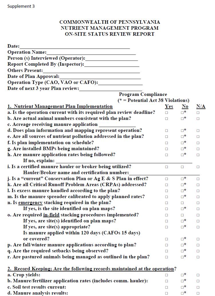
128 Page 128
129 Page 129
130 Attachment 2 FMT-9 Timber Sale Inspection and Completion Report Page 130
131 Page 131
BMP Verification: What is it and How Will it Impact Pennsylvania?
 BMP Verification: What is it and How Will it Impact Pennsylvania? Chesapeake Bay Program Conservation District and Agency Staff Meeting March 13, 2017 + over 400 other unique practices approved by the
Pennsylvania / NRCS Potomac Pilot Remote Sensing Project Chesapeake Bay Ag Workgroup
 Pennsylvania / NRCS Potomac Pilot Remote Sensing Project Chesapeake Bay Ag Workgroup July 21, 2016 Tom Wolf, Governor Patrick McDonnell, Acting Secretary Introduction and Action Requested NRCS Methodology
Manure Management Manual Revisions
 Manure Management Manual Revisions Jim Spontak PA DEP Farms In PA 63,136 farms in PA 33813 have livestock Average farm is 124 acres, about 75% under 200 acres Women as the primary farm operator increased
State Conservation Commission Act 38 Updates
 State Conservation Commission Act 38 Updates 2017 Pennsylvania Inter-Agency Nutrient Management Annual Conference November 2 and 16, 2017 Frank X. Schneider Director, Nutrient and Odor Management Programs
Agronomy Facts 40 Nutrient Management Legislation in Pennsylvania: A Summary of the 2006 Regulations
 Agronomy Facts 40 Nutrient Management Legislation in Pennsylvania: A Summary of the 2006 Regulations Introduction In spring 1993, the Pennsylvania Nutrient Management Act (Act 6) became law. On October
CAFO Fact Sheet series Fact Sheet #12: CAFO Requirements for the Beef Production Area By Brent Auvermann, Texas A&M University
 CAFO Fact Sheet series Fact Sheet #12: CAFO Requirements for the Beef Production Area By Brent Auvermann, Texas A&M University Disclaimer This fact sheet reflects the best professional judgment of the
USC BMP Definitions - Agricultural Best Management Practices (including NEIEN Code Id)
") USC BMP Definitions - Agricultural Best Management Practices (including NEIEN Code Id) Animal Waste Management Systems or Waste Storage Facility (840, 23) Practices designed for proper handling, storage,
USC BMP Definitions - Agricultural Best Management Practices (including NEIEN Code Id) Animal Waste Management Systems or Waste Storage Facility (840, 23) Practices designed for proper handling, storage,
VIRGINIA POLLUTION ABATEMENT (VPA) PERMIT APPLICATION. FORM B - ANIMAL FEEDING OPERATIONS (AFOs)
 PERMIT APPLICATION. FORM B - ANIMAL FEEDING OPERATIONS (AFOs)") VIRGINIA POLLUTION ABATEMENT (VPA) PERMIT APPLICATION FORM B - ANIMAL FEEDING OPERATIONS (AFOs) Department of Environmental Quality Rev. 02-2013 VIRGINIA POLLUTION ABATEMENT (VPA) PERMIT APPLICATION FORM
VIRGINIA POLLUTION ABATEMENT (VPA) PERMIT APPLICATION FORM B - ANIMAL FEEDING OPERATIONS (AFOs) Department of Environmental Quality Rev. 02-2013 VIRGINIA POLLUTION ABATEMENT (VPA) PERMIT APPLICATION FORM
Nutrient and Manure Management in PA
 Nutrient and Manure Management in PA Animal Operations in PA All Animal Operations (AOs) All operations generating or utilizing manure Regulated by PA DEP Concentrated Animal Operations (CAOs) High animal
Nutrient Management Legislation in Pennsylvania:
 Agronomy Facts #40 Nutrient Management Legislation in Pennsylvania: A Summary of the New Regulations, 2006 Introduction In spring 1993, the Pennsylvania Nutrient Management Act (Act 6) became law. On October
Statewide Results (Final Target)
") Statewide Results (Final Target) Nutrient Trading in Maryland 2017 National Watershed and Stormwater Conference April 4, 2016 Jason Keppler Watershed Implementation Program Nitrogen Sector 2009 2025 Allocation
Statewide Results (Final Target) Nutrient Trading in Maryland 2017 National Watershed and Stormwater Conference April 4, 2016 Jason Keppler Watershed Implementation Program Nitrogen Sector 2009 2025 Allocation
Section 1 - General Information (All farms must complete this section)
") Section 1 - General Information (All farms must complete this section) This section includes a contact information page for the plan listing the farm name and address, the plan preparer name and address
Section 1 - General Information (All farms must complete this section) This section includes a contact information page for the plan listing the farm name and address, the plan preparer name and address
Reporting of USDA Conservation Practices for Chesapeake Bay
 Reporting of USDA Conservation Practices for Chesapeake Bay Olivia H. Devereux, DEC, Inc. December 6, 2012 BMP Verification Review Panel with Dean Hively, USGS EGSC USGS Project Objectives To assist the
Chesapeake Bay s Problems
 Environmental Issues for the Chesapeake Bay Russ Perkinson Virginia State Feed Association Conference February 16, 2011 Chesapeake Bay s Problems Congressional appropriation of $27 million for six year
CBP Implementation Plan
 York County Conservation District CBP Implementation Plan March 2014 York County Conservation District 118 Pleasant Acres Road York, PA 17402 Phone: (717) 840-7430 www.yorkccd.org 1 Table of Contents Introduction
Cornell University Environmental Compliance and Sustainability Office. Concentrated Animal Feeding Operations Manual
 Cornell University Environmental Compliance and Sustainability Office Manual Table of Contents Program Summary... 1 Introduction... 2 Definitions... 3 Roles and Responsibilities... 3.1 ECOS... 3.2 College/Unit...
RE: Public Comment Invited to Help Develop State Plan to Improve Local Water Health in Chesapeake Bay Watershed Counties
 July 7, 2017 Pennsylvania Department of Environmental Protection Policy Office Rachel Carson State Office Building PO Box 2063 Harrisburg, PA 17105-2063 (via electronic mail to ecomment@pa.gov ) RE: Public
E3 Model Scenario Purpose and Definitions
 E3 Model Scenario Purpose and Definitions Gary Shenk (USGS) Jeff Sweeney (EPA) Chesapeake Bay Program Office Water Quality GIT Meeting August 14, 2017 Documentation of E3 and Planning Targets Chesapeake
APPENDIX A. Nutrient Trading Criteria Specific for the Chesapeake Bay Watershed
 Purpose: APPENDIX A Nutrient Trading Criteria Specific for the Chesapeake Bay Watershed The purpose of Appendix A is to provide additional program specific information regarding the use and incorporation
Maryland Phase II WIP Strategies. MONTGOMERY Agriculture - Annual Practices
 Maryland Phase II Strategies MONTGOMERY Agriculture - Annual Practices BMP Name Conservation Tillage Acres/Year 28,436 27,984 27,677 Cover Crop Acres/Year 4,275 10,816 11,000 Cropland Irrigation Management
Agricultural NPS Measures. Kevin Wagner Aaron Wendt
 Agricultural NPS Measures Kevin Wagner Aaron Wendt How are Ag BMPs Implemented? Texas Conservation Partnership Providing Conservation Assistance to Private Landowners for 70 Years LOCAL- 217 Soil and Water
PA Chesapeake Bay Phase II Watershed Implementation Plan Schuylkill County Planning Targets
 PA Chesapeake Bay Phase II Watershed Implementation Plan Schuylkill County Planning Targets What are Planning Targets? The Chesapeake Bay TMDL established regulatory waste load allocations and load allocations
Attachment # 1. Commonwealth of Pennsylvania. Pennsylvania Code. Title 25. Environmental Protection. Department of Environmental Protection
 Attachment # 1 Commonwealth of Pennsylvania Pennsylvania Code Title 25. Environmental Protection Department of Environmental Protection Chapter 102.4 1 Attachment #1 Pennsylvania Code, 102.4 Erosion and
2017 Revised Guide for Chesapeake Bay Water Quality Two-year Milestones
 2017 Revised Guide for Chesapeake Bay Water Quality Two-year Milestones Purpose Based upon agreements by the Chesapeake Executive Council beginning in 2008, EPA created an accountability framework that
CHAPTER 91. GENERAL PROVISIONS ****
 8-1-03 12 noon. version CHAPTER 91. GENERAL PROVISIONS * 91.1 Definitions. AEU--Animal equivalent unit One thousand pounds live weight of livestock or poultry animals, regardless of the actual number of
AFOs, CAFOs and MAFOs
 AFOs, CAFOs and MAFOs Presented by Gary F. Kelman, Chief Animal Feeding Operation Division Maryland Department of the Environment March 9, 2017 Topics 1. Watersheds 2. Definitions 3. New Sources 4. New
Pennsylvania s Phase III Watershed Implementation Plan
 Pennsylvania s Phase III Watershed Implementation Plan Informational Meeting Pennsylvania House and Senate Agriculture and Rural Affairs Committees August 16, 2017 Agenda Why Are We Doing This? Progress
NUTRIENT TRACKING TOOL
 NUTRIENT TRACKING TOOL A Cooperative Project Between Texas Institute for Applied Environmental Research (TIAER) USDA NRCS USDA ARS US EPA Funding support for this project was provided in part through a
COMPREHENSIVE NUTRIENT MANAGEMENT PLAN REVIEW CHECKLIST FOR CERTIFIED CNMP PROVIDERS
 Customer Name: CNMP Preparer s Name: CNMP Reviewer s Name and Date: COMPREHENSIVE NUTRIENT MANAGEMENT PLAN REVIEW CHECKLIST FOR CERTIFIED CNMP PROVIDERS COMPONENT Yes No NA 1. Overview - Brief statement
U.S. Environmental Protection Agency s Interim Expectations for the Phase III Watershed Implementation Plans
 U.S. Environmental Protection Agency s Interim Expectations for the Phase III Watershed Implementation Plans The U.S. Environmental Protection Agency (EPA) provided expectations for the Phase I 1 and Phase
Agriculture Action Packet DRAFT Attachment # FARM MAP EXAMPLE DRAFT
 Attachment # FARM MAP EXAMPLE Attachment # Conservation Systems to Meet the PA E&S Guidelines to be Used as an Interim Guideline when a Plan Meeting Soil Loss (T) Cannot be Obtained Guiding Principles
MDA BMP Functional Equivalents. Update WQGIT 11/12/13
 MDA BMP Functional Equivalents Update WQGIT 11/12/13 Executive Order 12508 In January of 2009, President Obama issued Executive Order (EO) 12508 on the Chesapeake Bay. May 12, 2010, the EO Strategy was
Use of Market and Voluntary Approaches for Reducing Nonpoint Source Pollution in the Chesapeake Bay Watershed
 Use of Market and Voluntary Approaches for Reducing Nonpoint Source Pollution in the Chesapeake Bay Watershed Dr. Marc Ribaudo Economic Research Service USDA NutriTrade Workshop May 16, 2016 The views
Watch Us WIP, Now Watch Us Bay Bay: Delaware s Choreographed Approach to Chesapeake Bay Restoration
 Watch Us WIP, Now Watch Us Bay Bay: Delaware s Choreographed Approach to Chesapeake Bay Restoration Session Presenters Marcia Fox, DNREC, Nonpoint Source Program Brooks Cahall, DNREC, Drainage Program
Maryland s Water Quality Trading Program. Phase II Agricultural Nutrient Trading in Maryland
 Maryland s Water Quality Trading Program Phase II Agricultural Nutrient Trading in Maryland Compensation ($) Buyer Nutrient Credits Seller John Rhoderick Maryland Department of Agriculture Agricultural
COST SHARE AND TECHNICAL ASSISTANCE PROGRAMS FOR IMPLEMENTING BEST MANAGEMENT PRACTICES TO IMPROVE WATER QUALITY
 SCS 2010 12 COST SHARE AND TECHNICAL ASSISTANCE PROGRAMS FOR IMPLEMENTING BEST MANAGEMENT PRACTICES TO IMPROVE WATER QUALITY Jennifer L. Peterson, Program Specialist, Water Quality Larry A. Redmon, Professor
Subchapter D. NUTRIENT MANAGEMENT
 Subchapter D. NUTRIENT MANAGEMENT Sec. GENERAL PROVISIONS 83.201. Definitions. 83.202. Scope. 83.203. Purpose. 83.204. [Reserved]. 83.205. Preemption of local ordinances. 83.206. Limitation of liability.
Proposed Interim Application Reduction Efficiency
 Proposed Interim Application Reduction Efficiency 1 Terminology Historically, CBP has referred to application reduction as nutrient management Comprehensive nutrient management involves having the correct
BUREAU OF WATERSHED MANAGEMENT PROGRAM GUIDANCE. Feed Storage Area Runoff Controls for CAFOs X/X/2016. EGAD Number: 3800-XXXX-XX
 The Feed Storage Area Runoff Controls for CAFOs guidance was developed to provide assistance to the DNR Runoff Management Program, CAFO owners and operators, and consultants who work with CAFOs. The guidance
Title 130 Livestock Waste Control Regulations: Summary of Land Application Requirements Amended Effective October 4, 2011
 Title 130 Livestock Waste Control Regulations: Summary of Land Application Requirements Amended Effective October 4, 2011 References to land application of animal manures were extracted from Title 130
Protocol for Setting Targets, Planning BMPs and Reporting Progress for Federal Facilities and Lands
 June 22, 2015 Protocol for Setting Targets, Planning BMPs and Reporting Progress for Federal Facilities and Lands Purpose This document describes the process for setting nitrogen, phosphorus and sediment
Manure Management Manual Revisions. Ag Advisory Board June 16, 2010
 Manure Management Manual Revisions Ag Advisory Board June 16, 2010 Timeline December AAB Presentation, Subcommittee was formed February and April updates were given to AAB January thru May: Workgroup Meetings
Sector Load Growth Demonstration Technical Memorandum
 Sector Load Growth Demonstration Technical Memorandum VERSION 1.0 Point Source Load Sectors: MS4s, Construction, CAFOs, Municipal and Industrial WWTP, CSOs and Air Deposition and Emissions Subject to Federal
Assessment of NRCS Remote Sensing Pilot in Potomac River Basin of Pennsylvania
 Assessment of NRCS Remote Sensing Pilot in Potomac River Basin of Pennsylvania Final Report December 13, 2016 Prepared for U.S. Environmental Protection Agency, Chesapeake Bay Program Office and Pennsylvania
New York State Animal Agriculture Program Assessment
 New York State Animal Agriculture Program Assessment Final Prepared by: U.S. Environmental Protection Agency Region 2 290 Broadway New York, NY 10007-1866 February 2015 New York Animal Agriculture Program
Resource Enhancement and Protection Program. Guidelines Fiscal Year 2016 (July 1, 2016 June 30, 2017)
") Resource Enhancement and Protection Program Guidelines Fiscal Year 2016 (July 1, 2016 June 30, 2017) State Conservation Commission 2301 North Cameron Street Harrisburg, PA 17110 Phone: (717) 787-8821 Fax:
Resource Enhancement and Protection Program Guidelines Fiscal Year 2016 (July 1, 2016 June 30, 2017) State Conservation Commission 2301 North Cameron Street Harrisburg, PA 17110 Phone: (717) 787-8821 Fax:
NRCS has provided a summary report of activities in the Chesapeake Bay watershed in Pennsylvania between 2008 and 2015 for Committee members today.
 1 Presentation to Agriculture and Rural Affairs Committee and Environmental Resources and Energy Committee by Denise Coleman, State Conservationist USDA Natural Resources Conservation Service (NRCS) Good
Whatcom County Farm Plan
 Whatcom County Farm Plan Planning Workbook: Checklist and Action Plan For use with the publication: Tips on Land and Water Management For: Land Owner Address Date Introduction Conservation planning means
Agriculture & Water Quality Shifting Perceptions & Shifting Policies
 Agriculture & Water Quality Shifting Perceptions & Shifting Policies Associate Martha Noble Senior Policy National Sustainable Agriculture Coalition Founded 1988 National coalition of 84 grassroots family
RESTORE CLEAN WATER ACTIONS: Federal Water Quality Two-Year Milestones for
 January 7, RESTORE CLEAN WATER ACTIONS: Federal Water Quality Two-Year Milestones for - The Executive Order (EO) 13508 Strategy calls upon federal agencies to join the Chesapeake Bay watershed jurisdictions
Permitting Animal Feeding Operations in Maryland
 Permitting Animal Feeding Operations in Maryland Presented by Gary F. Kelman, MS, CEP Chief, Animal Feeding Operation Division Maryland Department of the Environment May 10, 2017 Topics MDE and MDA; Watershed
Action Packet for Agriculture
 Pennsylvania Water Quality Action Packet for Agriculture A Self Assessment and Planning Tool for Water Quality Protection Under the PA Clean Streams Law Funded by Pennsylvania Department of Environmental
e-cfr Data is current as of June 27, 2014
 Page 1 of 5 ELECTRONIC CODE OF FEDERAL REGULATIONS e-cfr Data is current as of June 27, 2014 Title 40: Protection of Environment PART 122 EPA ADMINISTERED PERMIT PROGRAMS: THE NATIONAL POLLUTANT DISCHARGE
Technical Training and Certification Program Individual Development Plans for technical employees
 Technical Training and Certification Program Individual Development Plans for technical employees Purpose: The goal of the Technical Training and Certification Program (TTCP) is developing and maintaining
EPA Animal Agriculture Program Assessments For More Information Chesapeake Bay Commission Meeting November 5, 2015
 EPA Animal Agriculture Program Assessments For More Information Chesapeake Bay Commission Meeting November 5, 2015 Kelly Shenk, EPA Region III, Agricultural Advisor shenk.kelly@epa.gov 410.267.5728 1 EPA
Government Conservation Programs
 Government Conservation Programs Policy Resolutions Webinar 2017 Illinois Farm Bureau Governmental Affairs & Commodities Division Lyndsey Ramsey Assoc. Director of Natural and Environmental Resources CURRENT
WHATCOM COUNTY STANDARD FARM CONSERVATION PLAN PLANNING WORKBOOK: Checklist and Action Plan
 WHATCOM COUNTY STANDARD FARM CONSERVATION PLAN PLANNING WORKBOOK: Checklist and Action Plan For use with the publication: Tips on Land and Water Management For: Land Owner Address Date Introduction Conservation
Reservoir age, increasing human population,
 B-6249 02/12 Eagle Mountain Watershed Management Brent Clayton, Justin Mechell, David Waidler and Clint Wolfe* Reservoir age, increasing human population, and changing land uses have prompted the development
BUREAU OF CLEAN WATER
 COMMONWEALTH OF PENNSYLVANIA DEPARTMENT OF ENVIRONMENTAL PROTECTION BUREAU OF CLEAN WATER NATIONAL POLLUTANT DISCHARGE ELIMINATION SYSTEM (NPDES) STORMWATER DISCHARGES FROM SMALL MUNICIPAL SEPARATE STORM
COUNTY COUNCIL OF CECIL COUNTY, MARYLAND LEGISLATIVE SESSION DAY BILL NO
 COUNTY COUNCIL OF CECIL COUNTY, MARYLAND LEGISLATIVE SESSION DAY 2018-03 BILL NO. 2018-01 Title of Bill: Amendment - Zoning Ordinance Poultry Concentrated Animal Feeding Operation - CAFOS Synopsis: A Bill
Chesapeake Assessment Scenario Tool CAST
 Chesapeake Assessment Scenario Tool CAST Olivia H. Devereux Interstate Commission on the Potomac River Basin 12/13/2011 GOALS FOR CAST Provide a mechanism for the states to get input and commitment from
Animal Waste Management Systems Expert Panel Request for Proposals
 Animal Waste Management Systems Expert Panel Request for Proposals I. Summary: The U.S. Environmental Protection Agency Chesapeake Bay Program (CBP) through its Expert Panel Management Cooperative Agreement
15A NCAC 02B.0281 FALLS WATER SUPPLY NUTRIENT STRATEGY: STORMWATER REQUIREMENTS FOR STATE AND FEDERAL ENTITIES The following is the stormwater
 15A NCAC 02B.0281 FALLS WATER SUPPLY NUTRIENT STRATEGY: STORMWATER REQUIREMENTS FOR STATE AND FEDERAL ENTITIES The following is the stormwater strategy, as prefaced in Rule 02B.0275, for the activities
WHATCOM COUNTY STANDARD CONSERVATION FARM PLAN PLANNING WORKBOOK: Checklist and Action Plan
 WHATCOM COUNTY STANDARD CONSERVATION FARM PLAN PLANNING WORKBOOK: Checklist and Action Plan For use with the publication: Tips on Land and Water Management For: Land Owner Operator Address Date 0 Introduction
Agricultural Best Management Practices for Watershed Protection and Restoration. Citizens Advisory Council June 17, 2014
 Agricultural Best Management Practices for Watershed Protection and Restoration Citizens Advisory Council June 17, 2014 Overview Agriculture Regulatory Requirements Regional Ag Watershed Assessment Program
NUTRIENT MANAGEMENT PLANNING IN GEORGIA: AN OVERVIEW OF REGULATIONS, EDUCATION AND TECHNICAL ASSISTANCE
 NUTRIENT MANAGEMENT PLANNING IN GEORGIA: AN OVERVIEW OF REGULATIONS, EDUCATION AND TECHNICAL ASSISTANCE T.M. Bass 1, L.M. Risse 2, and J.W. Worley 3 AUTHORS: 1 Educational Program Specialist, 2,3 Extension
Data Collection for Nutrient Management Plan Development
 Data Collection for Nutrient Management Plan Development Beginning Act 38 nutrient management plan writers, when faced with writing their first nutrient management plan, are understandably met with a daunting
Resource Enhancement and Protection Program. Guidelines Fiscal Year 2018 (July 1, 2018 June 30, 2019)
") Resource Enhancement and Protection Program Guidelines Fiscal Year 2018 (July 1, 2018 June 30, 2019) State Conservation Commission 2301 North Cameron Street Harrisburg, PA 17110 Phone: (717) 787-8821 Fax:
Resource Enhancement and Protection Program Guidelines Fiscal Year 2018 (July 1, 2018 June 30, 2019) State Conservation Commission 2301 North Cameron Street Harrisburg, PA 17110 Phone: (717) 787-8821 Fax:
Ann Smith DEP-WPO
 Nutrient Trading Ann Smith DEP-WPO annsmith@state.pa.us Cost-effective Reductions Using Market Tools Nutrient Trading Compliance Plan calls for non-structural alternatives to infrastructure re upgrade.
Missouri Concentrated Animal Feeding Operation Nutrient Management Technical Standard
 Missouri Concentrated Animal Feeding Operation Nutrient Management Technical Standard March 4, 2009 Division of Environmental Quality Water Protection Program I Introduction A. Authority and Purpose Missouri
Dane County Land and Water Resources Land Conservation Division
 Dane County Land and Water Resources Land Conservation Division 2014 Adaptive Management Phosphorus Reductions Background As part of the 2014 Adaptive Management Pilot Project goals Dane County Land and
U.S. EPA s Responses to Pennsylvania s Documentation on Manure Management Plans Use of Book Values March 10, 2017
 U.S. EPA s Responses to Pennsylvania s Documentation on Manure Management Plans Use of Book Values March, 2017 BACKGROUND During its November 28, 2016 conference call, the Chesapeake Bay Program Partnership
Chesapeake Bay Program Watershed Modeling. Gary Shenk, Lewis Linker, Rich Batiuk Presentation to STAC 3/22/2011
 Chesapeake Bay Program Watershed Modeling Gary Shenk, Lewis Linker, Rich Batiuk Presentation to STAC 3/22/2011 1 Chesapeake Bay Partnership Models 2 Recent History of the Chesapeake Bay Program s Watershed
Analysis of Effectiveness of Ohio NRCS Practice Standards in Addressing Five Leading Causes of Water Quality Impairment
 Analysis of Effectiveness of Ohio NRCS Practice Standards in Addressing Five Leading Causes of Water Quality Impairment March 1, 2010 By: Rick Wilson, Environmental Specialist, Ohio EPA -Division of Surface
What Works: Farming Practices
 What Works: Farming Practices Forestry, Farming and Filtration: Productive Lands and Water Supplies Can Coexist September 23, 2010 St. Paul Center, Augusta, Maine Farming Practices Protect Water Nutrient
Fact Sheet #7 Reducing the Risk of Groundwater Contamination by Improving Livestock Waste Storage
 Fact Sheet #7 Reducing the Risk of Groundwater Contamination by Improving Livestock Waste Storage N E W M E X I C O FARM A SYST Farmstead Assessment System Fact Sheet #7 Reducing the Risk of Groundwater
Nutrient Management Plan Review Approach, Process & Guidelines
 Nutrient Management Plan Review Approach, Process & Guidelines Recommended Plan Review Process The review of an Act 38 NMP for recommendation for official approval involves three components: Administrative
Wisconsin s Improving Nutrient Management WI Dept. of Agriculture, Trade and Consumer Protection
 Wisconsin s Improving Nutrient Management Sue.Porter@WI.gov 608-224-4605 WI Dept. of Agriculture, Trade and Consumer Protection 2011 NM Highlights 1.8 M acres planned in 2011 up 23% 238 more farmers wrote
CHESAPEAKE BAY PROGRAM RESOURCE IMPROVEMENT PRACTICE DEFINITIONS AND VERIFICATION VISUAL INDICATORS REPORT
 Page 1 of 42 CHESAPEAKE BAY PROGRAM RESOURCE IMPROVEMENT PRACTICE DEFINITIONS AND VERIFICATION VISUAL INDICATORS REPORT Presented by the Agriculture Workgroup s Resource Improvement Technical Review Panel:
MINNEHAHA CREEK WATERSHED DISTRICT BOARD OF MANAGERS REVISIONS PURSUANT TO MINNESOTA STATUTES 103D.341. Adopted April 24, 2014 Effective June 6, 2014
 MINNEHAHA CREEK WATERSHED DISTRICT BOARD OF MANAGERS REVISIONS PURSUANT TO MINNESOTA STATUTES 103D.341 Adopted April 24, 2014 Effective June 6, 2014 EROSION CONTROL RULE 1. POLICY. It is the policy of
V. Eligible Practices A. Cost-Share Practices
 V. Eligible Practices A. Cost-Share Practices Sheet and Rill/Gully Erosion Resource Concern... 9 DSL-01 Permanent Vegetative Cover Establishment... 9 DSL-02 Permanent Vegetative Cover Improvement... 11
4. Present Activities and Roles
 4. Present Activities and Roles The present missions, authorities, activities and roles of the various agencies involved with flood protection, floodplain management and flood-damage reduction are identified
Bob Broz University of Missouri Extension
 Bob Broz University of Missouri Extension brozr@missouri.edu 573-882-0085 What is the purpose on the nutrient reduction committee? Reduce nutrient loading into the Mississippi River and into the Gulf of
CONSERVATION AND WILDLIFE PROGRAMS
 CONSERVATION AND WILDLIFE PROGRAMS Wes Harris Special Projects Coordinator Center for Agribusiness and Economic Development The University of Georgia wlharris@uga.edu TITLE II FARM SECURITY AND RURAL INVESTMENT
Chesapeake Bay Program Watershed Policy. PA Statewide Conference for Watershed Organizations March 6, 2017
 Chesapeake Bay Program Watershed Policy PA Statewide Conference for Watershed Organizations March 6, 2017 Agenda Chesapeake Bay Program Why Should You Care? Past Quick Overview Present Restoration Strategy
Pennsylvania Inter-Agency Nutrient Management Annual Conference TECHNICAL MANUAL VERSION 10 UPDATE
 Pennsylvania Inter-Agency Nutrient Management Annual Conference TECHNICAL MANUAL VERSION 10 UPDATE Frank Schneider Nutrient Management Program Director 717-705-3895 fschneider@pa.gov Jerry Martin Senior
Feedlot Financial Needs Report
 Feedlot Financial Needs Report for Feedlots with Less Than 300 Animal Units to Comply with Applicable State Rules and Statutes by October 1, 2010 Minnesota Board of Water and Soil Resources January 2008
Quittapahilla Creek Watershed Implementation Plan
 Quittapahilla Creek Watershed Implementation Plan Introduction Founded in 1997, the Quittapahilla Creek Watershed Association has been working with landowners, private organizations and public agencies
Riparian Forest Buffer Panel (Bay Area Incentive Programs)
") Program Buffer Incentive Program Virginia Agricultural BMP Cost- Share Program Virginia Agricultural BMP Cost- Share Program Practice Woodland Buffer Filter Area Loafing Lot Management System Incentive,
Program Buffer Incentive Program Virginia Agricultural BMP Cost- Share Program Virginia Agricultural BMP Cost- Share Program Practice Woodland Buffer Filter Area Loafing Lot Management System Incentive,
15A NCAC 02B.0238 NEUSE RIVER BASIN-NUTRIENT SENSITIVE WATERS MANAGEMENT STRATEGY: AGRICULTURAL NITROGEN REDUCTION STRATEGY The following
 15A NCAC 02B.0238 NEUSE RIVER BASIN-NUTRIENT SENSITIVE WATERS MANAGEMENT STRATEGY: AGRICULTURAL NITROGEN REDUCTION STRATEGY The following requirements apply to all persons in the Neuse River Basin who
EXHIBIT "B" LAND USE REGULATIONS MARK TWAIN LAKE
 EXHIBIT "B" LAND USE REGULATIONS MARK TWAIN LAKE The Lessee agrees to conduct all farming operations in accordance with the land use practices set forth and in accordance with an approved annual land use
Funding, Progress, and Other Issues Regarding Agricultural Nonpoint Source Pollution
 Funding, Progress, and Other Issues Regarding Agricultural Nonpoint Source Pollution Paul Van Lenten, Jr. Legislative Fiscal Analyst November 14, 2012 1 What is Nonpoint Source Pollution? Nonpoint source
FOREST, WETLANDS AND HABITAT
 FOREST, WETLANDS AND HABITAT A SYST FOR FOREST, WETLANDS AND HABITAT LANDOWNERS FAS 115 October 2017 Major Revision Destroy Old For MAEAP Verification: Contact the MAEAP Office at the Michigan Department
Overview of Clean Water Act CAFO Rule - Outline
 Overview of Clean Water Act CAFO Rule - Outline CWA prohibits the discharge of pollutants from point sources into waters of the US (WOUS) without a permit Point sources include concentrated animal feeding
Center for Nutrient Solutions (CNS) Nutrient Solution Scenarios Concept Paper September 5, 2014 Draft
 Nutrient Solution Scenarios Concept Paper September 5, 2014 Draft") I. Introduction Center for Nutrient Solutions (CNS) Nutrient Solution Scenarios Concept Paper September 5, 2014 Draft A key goal of the CNS is to develop and test tools for evaluating tactics and strategies
I. Introduction Center for Nutrient Solutions (CNS) Nutrient Solution Scenarios Concept Paper September 5, 2014 Draft A key goal of the CNS is to develop and test tools for evaluating tactics and strategies
Tech Manual Update Bulletin
 Tech Manual Update Bulletin Pennsylvania s Nutrient Management Act Program VERSION 10 OCTOBER 2017 The Pennsylvania Act 38 Nutrient Management Program Technical Manual has been developed in order to provide
Pennsylvania s Chesapeake Bay Tributary Strategy Implementation Plan for Sewage Facilities Planning
 The strategy outlined in this guidance document is intended to supplement existing requirements. Nothing in the strategy shall affect regulatory requirements. The information herein is not an adjudication
Site Condition Evaluation & Environmental Benefits Report
 Site Evaluation & Environmental Benefits Report Background The New York State Conservation Reserve Enhancement Program is a collaborative effort between the USDA and the State of New York. The goal of
Wisconsin Wastewater Operators Association. Protecting Our Water Resources: The Future Bill Hafs - NEW Water 10/2014
 Wisconsin Wastewater Operators Association Protecting Our Water Resources: The Future Bill Hafs - NEW Water 10/2014 The Fox River Contributes 1/3 of All Nutrients to Lake Michigan APRIL 15, 2011 Photo
15A NCAC 02B.0264 JORDAN WATER SUPPLY NUTRIENT STRATEGY: AGRICULTURE (See S.L ) This Rule sets forth a process by which agricultural
 This Rule sets forth a process by which agricultural") 15A NCAC 02B.0264 JORDAN WATER SUPPLY NUTRIENT STRATEGY: AGRICULTURE (See S.L. 2013-395) This Rule sets forth a process by which agricultural operations in the Jordan watershed will collectively limit
15A NCAC 02B.0264 JORDAN WATER SUPPLY NUTRIENT STRATEGY: AGRICULTURE (See S.L. 2013-395) This Rule sets forth a process by which agricultural operations in the Jordan watershed will collectively limit