U.S. DEPARTMENT OF TRANSPORTATION Federal Highway Administration. RECORD OF DECISION March 2013
|
|
|
- Gertrude Singleton
- 6 years ago
- Views:
Transcription
1 U.S. DEPARTMENT OF TRANSPORTATION Federal Highway Administration RECORD OF DECISION March 2013 Grand Parkway (State Highway 99) Segment C From United States Highway 59 (US 59) To State Highway 288 (SH 288) Brazoria and Fort Bend Counties, Texas FHWA-TX-EIS F CSJ Nos , , , ,
2 CONTENTS I. INTRODUCTION and SUMMARY... 1 II. DECISION... 2 III. ALTERNATIVES CONSIDERED... 4 A. No-Build Alternative... 5 B. Build Alternative... 6 C. Conclusion... 8 IV. SECTION 4(f) and SECTION 6(f) V. MEASURES TO MINIMIZE HARM A. Land Use B. Geology, Soils, and Farmlands C. Social D. Economics E. Pedestrians and Bicyclists F. Air Quality G. Noise Analysis H. Water Quality I. Permits J. Wetlands and Vegetative Communities K. Floodplains and Waterbody Modifications L. Wildlife M. Threatened and Endangered Species N. Cultural Resources O. Hazardous Materials P. Visual and Aesthetic Qualities Q. Energy i
3 R. Construction Impacts S. Indirect Effects T. Cumulative Impacts U. Regional Indirect and Cumulative Effects of Tolled Facilities and Managed Lanes VI. MONITORING OR ENFORCEMENT PROGRAM VII. COMMENTS RECEIVED ON THE FEIS VIII. CONCLUSION EXHIBIT 1: Grand Parkway Segment C Selected Alternative... 1 EXHIBIT 2: Proposed 2035 Toll/HOT Managed Lanes... 1 EXHIBIT 3: Environmental Justice Zones... 3 EXHIBIT 4: 2035 No Build Regional Managed Lanes... 5 Appendix A: List of Mitigation Measures and Commitments... 1 ii
4 I. INTRODUCTION and SUMMARY This document is the Federal Highway Administration s (FHWA) Record of Decision (ROD) regarding Segment C of the Grand Parkway State Highway 99 (SH 99) project. This ROD approves FHWA s selection of the Preferred Alternative, henceforth referred to as the Selected Alternative, as described in the Grand Parkway SH 99 Segment C Final Environmental Impact Statement (FEIS) dated August 8, The FEIS and the entire project record are available for review by written request to the Texas Division of the FHWA. This approval constitutes FHWA s acceptance of the Selected Alternative for the Grand Parkway Segment C and completes the environmental process for the 26.9-mile section of SH 99 from United States Highway 59 (US 59) to State Highway 288 (SH). As set forth in this ROD, the Selected Alternative best serves the need for and purpose of this project. The proposed Grand Parkway (SH 99) is planned as an approximate 180+ mile circumferential new location transportation facility around the Houston metropolitan area. The proposed facility will traverse Harris, Montgomery, Liberty, Chambers, Galveston, Brazoria, and Fort Bend counties, Texas and provide access to radial highways such as Interstate Highway (IH) 10, IH 45, US 290, US 59, and SH 249. For Segment C, the alternative alignments were developed within the project area to fulfill the need for and purpose of the project, to minimize potential environmental impacts, and to respond to public/landowner and resource agency comments. A Recommended Alternative Alignment was not identified in the Draft Environmental Impact Statement (DEIS, May 2000 and DEIS Reevaluation, July 21, 2011) but was identified in the Final Environmental Impact Statement (FEIS, August 8, 2012). This selection was based, in accordance with 23 CFR , on the best overall public interest with input from public and resource agencies and analysis and comparison of the potential effects on the physical, biological, and human environments of each alternative alignment. After consideration of the agency and public comments received on the DEIS, as well as updated environmental data, a Selected Alternative Alignment was selected in the FEIS. It is comprised of a combination of alignments investigated during the study process as documented in this FEIS. A complete description of the Selected Alternative Alignment that emerged from the study process is provided in detail in the FEIS Volume I, Section During the study process, some of Preferred Alternative Alignment segments were shifted, and additionally some new segments were created in finalizing the Selected Alternative, to better avoid and minimize impacts and address comments received at the public hearings and workshops. As set forth in this ROD, the Selected Alternative best serves the need for and purpose of this project, avoids and minimizes impacts, and responds to public/agency comments. Page - 1
5 The Grand Parkway Segment C project, as described, is included the Houston-Galveston Area Council s (H-GAC) Transportation Improvement Plan (TIP) and the long-range plan (2035 RTP Update). The USDOT determined that the 2035 RTP Update and the TIP conformed to the requirements of the State Implementation Plan (SIP) for the Houston- Galveston ozone non-attainment area on January 25, 2011 and November 1, 2012 respectively. The project is also included in the H-GAC Congestion Management Program. The Grand Parkway Segment C project has been independently evaluated by the FHWA and determined to adequately and accurately discuss the need, purpose, alternatives, environmental issues, impacts and appropriate mitigation measures. FHWA has reviewed all of the relevant documentation and materials. Based upon our own independent review and analysis, we find that the August 2012, Final Environmental Impact Statement Grand Parkway State Highway 99 Segment C analyzed and considered all the relevant potential environmental impacts and issues; therefore, the project as proposed meets all federal requirements. This ROD is executed in conformance with the Council on Environmental Quality (CEQ) regulation implementing the National Environmental Policy Act of 1969 (NEPA) and documents FHWA compliance with NEPA and all other applicable federal statutes, regulations, and requirements. The sections that follow provide information that has been essential in the decision-making process. Several public meetings have occurred to provide information regarding the Grand Parkway Segment C project and receive comments on the project. A project internet website ( was also developed and maintained to provide project information and receive comments. II. DECISION The FHWA decision is to approve the Selected Alternative (see Exhibit 1 in this ROD), which is a 26.9-mile, four-mainlane controlled-access toll road facility with intermittent frontage roads located within a 400-foot right-of-way (ROW) and will be built to accommodate a 70-mile per hour design speed. The Selected Alternative begins in Fort Bend County at US 59 and extends 26.9 miles to SH 288 in Brazoria County, Texas. Subsequent to the issuance of the Notice of Intent to prepare an EIS and the circulation of the FEIS for the Grand Parkway Segment C project, the Texas Transportation Commission in conjunction with the FHWA and American Association of State Highway Transportation Officials (AASHTO) dually designated US 59 from Interstate 610 to 0.2 miles north of Spur 529 in Rosenberg as Interstate 69 (I-69). As a result, the Grand Parkway Segment C project now has a project termini in Fort Bend County with US 59/I-69. The Selected Alternative is a combination of Representative Alternative segments: A1, A2, A3.1, S1-b, B4.2, W1, G3.2, X1, G5.2, Y1, G6.2, G7, and G8 as adjusted to minimize potential impacts (see Exhibit 1 in this ROD). The Selected Alternative also involves construction of direct Page - 2
6 connector ramps at US 59 and SH 288 to provide for fully directional interchanges. Identifying these Representative Alternative segments as the Selected Alternative are based upon their ability to meet the need and purpose of the project, public and agency input, and the minimization and avoidance of environmental resources and human environment, including indirect and cumulative impacts (FEIS Sections 5 and 6). The basis for this ROD is supported by the information provided in the FEIS and supporting technical documents; the associated administrative record; and input received from the public and interested local, state and federal agencies. The FHWA considered the potential impacts of the project and alternative courses of action under NEPA while balancing the need for safe and efficient transportation with national, state, and local environmental protection goals. FHWA notes that its statutory responsibility under 23 United States Code (USC) 109(h) is to reach a project decision that is in the best overall public interest taking into account the need for safe, fast, and efficient transportation, and public services, while eliminating or minimizing adverse natural environmental and community effects. With respect to the process of avoiding and minimizing natural environmental and community effects, the alternatives analysis process included efforts to balance impacts across different resources. In accordance with USC)Title 23, Chapter 1, Section 109 (c)(2)(b), development of the Grand Parkway alignments included consideration for context sensitive solutions and guidance provided in the FHWA publication, Flexibility in Highway Design (published by FHWA in 1997). As stated in the FHWA guidance, For each potential project, designers are faced with the task of balancing the need for the highway improvement with the need to safely integrate the design into the surrounding natural and human environments (FHWA, 1997, pp.xi-xii). Also, in applying context sensitive solution principles, the alternative development process engaged the public in balancing community, cultural, aesthetic, environmental, and transportation needs. The FHWA decision provides the necessary environmental approval under NEPA for the construction of this new location highway facility within Brazoria and Fort Bend counties. The Grand Parkway Segment C is needed because there are inefficient connections between suburban communities and major radial roadways, the current and future transportation demand exceeds capacity, many roadways within the study area of Segment C have a high accident rate, and there is an increasing strain on transportation infrastructure from population and economic growth. The purpose of the project is to efficiently link the suburban communities and major roadways, enhance mobility and safety, and respond to economic growth. This type of facility is the design concept that best satisfies the need and purpose of the project to efficiently provide congestion relief, increased local and regional mobility, and increased capacity for hurricane evacuation needs. Additionally, the Grand Parkway Segment C will also provide an additional hurricane emergency evacuation route for the greater Houston area consistent with Minute Order No signed Page - 3
7 October 25, The circumferential route connects to numerous radial facilities that are often congested during an evacuation. As an example, when as many as two million people fled the Houston metroplex before Hurricane Rita on September 22, 2005, evacuees followed roadways leading to Austin, San Antonio, and Dallas. Severe congestion ensued and contra-flow lanes were eventually opened. The Grand Parkway Segment C could alleviate a portion of the congestion during mass evacuations thus creating safer and more efficient evacuation conditions. The ROW for the Selected Alternative will encompass approximately 1,131 acres of new transportation ROW and 225 acres of existing transportation ROW. The Selected Alternatives will include fully directional interchanges at US 59 and SH 288. According to the preliminary design, the Selected Alternative begins at the US 59 interchange and heads in a southerly direction along the existing Crabb River Road/FM 2759 for approximately 1 mile toward FM 762, with an interchange at Sansbury Boulevard. This portion of the facility is comprised of mainlanes and frontage roads. The facility continues on new location, without frontage roads, in a southerly direction for 11 miles, with interchanges at three crossings: FM 762, an extension of Reading Road, and the future extension of Peters Road. The remaining 14 miles will continue in an easterly direction towards SH 288 on new location with interchanges at FM 521, CR 48, and SH 288. The facility includes frontage roads between CR 48 and SH 288. In addition to the interchanges, the proposed facility will bridge the following waterbodies: Rabbs Bayou, Dry Creek, Big Creek (two crossings), Big Creek diversion channel, Waters Lake Bayou, Brazos River, Cow Lake, and Oyster Creek. The estimated project cost is $625,110,107. This cost estimate includes estimated construction cost, estimated ROW cost, estimated utilities cost, escalation, and inflation costs. The cost estimate does not include operations or maintenance costs after the Selected Alternative construction is complete. Environmental issues and proposed mitigation related to the construction of the Selected Alternative are detailed in the following sections. III. ALTERNATIVES CONSIDERED Throughout the transportation planning and project development process, a wide range of alternatives was considered using appropriate levels of environmental and engineering analysis. The alternatives were analyzed and advanced for more detailed study based on their ability to meet the identified project needs, their impact on the environment, and input received from the public, elected officials, and the environmental resource agencies. A detailed discussion of the alternative development is included in the FEIS (Volume I, Section 2.0) and its supporting documentation. The alternatives considered included: No-Build, Transportation System Management (TSM) Alternative; Travel Demand Management (TDM) Alternative; Modal Page - 4
8 Alternative (e.g. bus transit, high-occupancy vehicle (HOV) lanes, rail transit, bicycle and pedestrian); and Added Single Occupancy Vehicle Capacity Alternative (widen existing arterials, construct new arterials, and new controlled access highway). Additionally, a free or non-toll Build Alternative (controlled access, four-lane freeway on new location) was considered, but eliminated from further study. The non-toll Build Alternative will not be consistent with the 2035 Regional Transportation Plan (RTP) Update that identifies the addition of tolled facilities such as the Grand Parkway Segment C. Tolled facilities were determined necessary in order to fund transportation projects that could address current congestion and future growth in the Houston-Galveston Area Council (H-GAC) planning region. The 2035 RTP Update is consistent with 2001 Texas Legislation Senate Joint Resolution 16 that, upon voter approval, amended the Texas State Constitution to create Texas Mobility Fund and authorized grants and loans of money and issuance of obligations for financing the construction, reconstruction, acquisition, operation, and expansion of state highways, turnpikes, toll roads, toll bridges, and other mobility projects. H-GAC has included tolling as an integral part of its financial planning strategy for the Grand Parkway as documented in their 2035 RTP Update plan. Only the new controlled access tolled highway (known as the Build Alternative) was found to fully meet the need and purpose for the project and was advanced for detailed study in the DEIS and FEIS. The No-Build Alternative was advanced for baseline comparisons for the Build Alternative. The alternatives evaluated and advanced for detailed study include: A. No-Build Alternative The No-Build Alternative does not include the construction of Segment C of the Grand Parkway. This alternative transportation mode consists of a continuation of the existing transportation facilities including the construction of planned and/or committed roadway in the study area. Committed improvements are those projects included in the construction 2035 RTP Update excluding new construction of the Grand Parkway Segment C project. The No-Build Alternative would not adequately address the need and purpose for the project. It would not reduce congestion or improve mobility on existing roadways within the study area and does not provide the needed hurricane evaluation for the Houston region. However, the No- Build Alternative was retained as a basis for comparison with the alternatives carried forward for detailed study. Page - 5
9 B. Build Alternative The Build Alternative was developed by utilizing a three-phase screening process for developing alignment alternatives. As alternatives were screened and eliminated, more-detailed levels of study were performed. 1. Phase 1 Screening Process Universe of Alternatives to Reasonable Alternatives The Phase 1 screening process included data collection; constraints map development, development of a Universe of Alternatives, a Public Scoping Meeting/MIS Initiation Meeting, screening of the Universe of Alternatives, identification of Reasonable Alternatives, and a Public Workshop. The Universe of Alternatives was generally developed for 1,000-foot-wide corridors through the study area but were narrowed to 500-foot in the northern section because of denser development. The Universe of Alternatives was comprised of 41 independent segments which were evaluated geographically by their location within the study area (north, central, and south). The screening evaluations resulted in the elimination of 12 segments between project termini. The identification of Reasonable Alternatives to advance for additional study was performed on October 16, 1998, with input from state and federal resource agencies, TxDOT s Houston District, and the FHWA. The screening was performed based on all project data, including input from the resource agencies, local officials, and the public. The Reasonable Alternatives were presented to the public at the Public Workshop on October 27, 1998 and revisions to the alternatives were made based on public input. 2. Phase 2 Screening Process-Reasonable Alternatives to Representative Alternatives The Phase 2 screening process included the preparation of preliminary schematic designs for each of the Reasonable Alternatives. Environmental fieldwork was performed within the 500- to 1,000-foot-wide corridors for each Reasonable Alternative, and impacts were quantified through the entire width of the corridor. Also, during Phase 2 work, two segments were added to the study. The Reasonable Alternatives were composed of 32 segments (FEIS, Volume 2, Appendix D) and totaled 40 possible alternative options for getting from one project terminus to the other project terminus. The evaluation of Reasonable Alternatives provided the study team with data that led to the elimination of some of the 40 alternative options. Those alternatives remaining for consideration after developing preliminary schematic designs and performing environmental field investigations were called the Representative Alternatives of which there were eight (8). These Representative Alternatives were evaluated in the DEIS but a Selected Alternative was not identified. The Representative Alternatives were presented to the public at a Public Hearing on June 13, 2000 and revisions to the alternatives were made based on public input and potential environmental impacts. Based on input received at the public hearing and potential impacts identified during the environmental analysis, shifts were made to the Representative Alternatives. Page - 6
10 3. Phase 3 Screening Process-Representative Alternative to Selected Alternative The Phase 3 screening process included additional public outreach, alternative refinements, a re-evaluation of the DEIS, and a detailed environmental evaluation of the final preferred design concept derived from the Representative Alternatives. The revised Representative Alternatives were developed and advanced for additional study and a Selected Alternative was presented to the public on November 14, The rationale for identifying the Selected Alternative: Public comments were received suggesting that the proposed Grand Parkway Segment C not directly impact the Brazos Bend State Park. The Selected Alternative is approximately 1.5 miles from the park. Traffic noise impacts to the park were minimized. Public comments were received requesting the proposed Grand Parkway Segment C stay away from the George Observatory. The Selected Alternative is located about 3 miles from the observatory. The Selected Alternative minimizes impacts to the Bald Eagle s nest that is located within the project s study area. The Selected Alternative is located approximately 1,678 feet from the nest and is not within the primary Final Environmental Impact Statement Proposed Grand Parkway Segment C (SH 99) management zone as defined by the U.S. Fish and Wildlife Service (USFWS). A Section 7 consultation process was completed to ensure impacts to the eagle are avoided. Impacts to the community of Iowa Colony were avoided. The Selected Alternative utilizes existing Crabb River Road, which reduces the amount of undisturbed ROW that will be required to construct the proposed Grand Parkway Segment C. The Selected Alternative minimizes the bisecting of private property. The Selected Alternative utilizes a straighter horizontal alignment, which results in a lower construction costs along the eastern project limits. The Selected Alternative avoids existing residential and commercial development. The Selected Alternative was again presented to the public in an August 2007 public meeting. This meeting was specifically held to inform the public that the Grand Parkway Segment C project will be advanced as a toll facility. Following the meeting, some of the Representative Alternative segments were again shifted to better avoid and minimize impacts, therefore creating new segments studied during Phase 3. Page - 7
11 The Representative Alternative alignment adjustments are described in detail in the FEIS, Section 2 and shown on Exhibit 13 in the FEIS Volume II). The shifts include: Segment W1 (replaces G2) was created after Segment G3.2 had been revised (see below). W1 provides for a more direct connection between Segment B4.2 and Segment G3.2. Segment G3.2 had previously not been included as a Representative Alternative due to its proximity to a protected species. However, the USFWS has since accepted the location of G3.2 and do not believe that a protected species is impacted by this segment. Therefore, Segment G3.2 was added back and included in the Selected Alternative. Segment X1 (replaces G5.1) was moved to the northern boundary of the George Ranch property limits to avoid leaving a George Ranch remainder, north of the Grand Parkway. Segment Y1 (replaces G5.3 and G6.1) was created at the request of a landowner to avoid crossing a livestock pond. Segment G6.2 was moved as result of Y1 moving. C. Conclusion Table 1 summarizes the impacts within the ROW for each of the Representative Alternatives as well as the Selected Alternative. A multi-step process for the recommendation of a Selected Alternative was followed after circulation of the DEIS and completion of a public review period and public hearing followed by the circulation of the DEIS Reevaluation. Data contained in the DEIS and DEIS Reevaluation, review comments from regulatory agencies, and comments from the public hearing process were used to further screen the Representative Alternatives. The FEIS documents the process used to also further identify the Selected Alternative and by closer examination of each option within the project area, the Selected Alternative is the Environmentally Preferred Alternative based on analysis and comparison of the potential effects on the physical, biological, and human environments of each alternative alignment and public and agency input from the public involvement process as summarized in the following paragraph. In accordance with USC Title 23 Chapter 1 Section 109 (c)(2)(b), development of the Grand Parkway Segment C project alignments included consideration for context sensitive solutions and guidance provided in the FHWA publication Flexibility in Highway Design (published by FHWA in 1997). As stated in FHWA guidance, For each potential project, designers are faced with the task of balancing the need for the highway improvement with the need to safely integrate the design into the surrounding natural and human environments (FHWA, 1997, pp.xi-xii). Page - 8
12 The Selected Alternative provides the best opportunity to avoid and minimize impacts to the natural, social, and cultural environment a while meeting the transportation need and purpose for the area. The impacts of the Selected Alternative were calculated using the most detailed design, which is a 300- to 400-foot ROW width. Approximately 1,131 acres of new ROW will be required for the Selected Alternative to accommodate the transportation facility, utility line adjustments, and the filing of aquatic resources including jurisdictional wetlands (Table 1). In addition to the rationale for identifying the Selected Alternative listed above, the following further supports the advancement of the Selected Alternative as the Environmentally Preferred Alternative. The Selected Alternative will have 6 commercial displacements, 14 residential displacements, and one church displacement. Only Representative Alternatives 1 and 3 would have less residential relocations; however, they would still impact the church, 6 commercial facilities as well as a cemetery which is avoided by the Selected Alternative. From a natural environment perspective, the Selected Alternative has higher impacts on undeveloped land (pasture/cropland/grassland) and non-forested wetlands, however it minimizes impacts to forested wetlands and forestland. The Selected Alternative also compares favorably (has similar impact or less impact) against most of the other alternatives with respect to water resources and historic resources. No known archeological resources listed in or eligible for the National Register of Historic Places are expected to be impacted. No listed threatened or endangered species will be impacted. The Selected Alternative would have a higher number of noise impacts than the other alternatives alignments presented in the FEIS; however, it should be noted that a detailed noise analysis was only performed on the Selected Alternative and was updated following the publication of the FEIS. A total of 19 noise receiver locations representing 64 impacted residences and 1 business will be impacted by traffic noise with the Selected Alternative. Public feedback and preference was taken into consideration throughout the alternatives analysis evaluation. In addition to public meetings, coordination meetings with regulatory agencies have been held. FEIS Volume I, Public and agency feedback, as well as continuous updates to land use data and public and agency coordination since the publication of the DEIS, May 2000 and DEIS Reevaluation, July 21, 2011 and publication of the FEIS in August 2012 resulted in a Selected Alternative based on public preference, environmental constraints, and engineering constraints. In determining the Environmentally Preferred Alternative, the FHWA and Texas Department of Transportation (TxDOT) balanced the impacts and factors of each alternative. As discussed above, avoidance, minimization and mitigation to floodplain and wetlands will continue as the project develops. Table 1 presents the impacts by alternative alignment, including the Selected Alternative as compared to the other alignment alternatives as they were presented in the FEIS (August 8, 2012). Page - 9
13 Table 1 Summary of Potential Resource Impacts/Involvement and Engineering Features for Representative Alternatives and the Selected Alternative Item Unit S* 1 Wetlands 1.1 Nonforested acres Forested acres Endangered Species Occurrence within 1 mile 2.1 Animals # sites Plants # sites Vegetative Communities 3.1 Forestland acres Pastureland/Grassland/ acres ,024 Cropland 3.3 Habitat Fragmentation y/n yes yes yes yes yes yes yes yes yes 4 Geologic 4.1 Geologic Sites # sites Prime Farmland acres Water Resources 5.1 River Crossings # of Major Stream Crossings # of Minor Stream Crossings # of Irrigation Canal/Ditch # of Crossings Stock Ponds # of Floodplains acres Floodways acres Hazardous Materials # sites Relocations 7.1 Commercial # of Single Family (Site Built) # of Single Family (Mobile # of Homes) 7.4 Single Family (Platted) # of Schools # of Churches # of Cemeteries # of Historic and Archeological Resources 8.1 Previously Recorded # of Archeological Sites (within ROW) 8.2 Historic Nonarcheological Resources (within APE) # of High-Probability Areas LF 28,200 28,200 37,500 37,500 27,575 27,575 36,875 36,875 40, Newly Recorded Archeological Sites (within ROW) # of Page - 10
14 Table 1 Continued Item Unit S* 9 Environmental y/n yes yes yes yes yes yes yes yes yes Justice Considerations 10 Noise and Air 10.1 Noise Receivers # of Air Quality NA NA NA NA NA NA NA NA NA NA 11 Engineering and Mobility 11.1 Length miles Terminated County # of Roads 11.3 Railroad Grade # of Separations 11.4 Grade Separations # of Ramps # of Construction y/n yes yes yes yes yes yes yes yes yes Sequencing Impacts 11.7 Utility Crossings # of ROW 12.1 Required ROW acres , Existing ROW acres Donated ROW acres Other Environmental Issues 13.1 Visual Impacts and high/ low low low low low low low low low Aesthetics low 13.2 Follows Existing miles Roadway ROW 13.3 Observatory Dark y/n no no no no no no no no no Northern Skies Impact 13.4 George Ranch y/n no no no no no no no no no Historical Park (private) Impacts 13.5 Potential 4(f) Issue y/n no no no no no no no no no (Cultural Resources) 13.6 Potential 4(f)/6(f) y/n no no no no no no no no no Issue (Parks and Public Lands) S* = Selected Alternative y/n = yes/no LF = Linear Feet NA = Not Applicable Page - 11
15 IV. SECTION 4(f) and SECTION 6(f) The Department of Transportation Act of 1966 (as amended and codified in 49 USC 303) prohibits the Secretary of Transportation from approving any program or project that requires the use of publicly owned land from a public park, recreation area, or wildlife and waterfowl refuge of national, state, or local significance or land of an historic site of national, state, or local significance unless there is no feasible or prudent alternative to the use of such land, and such program includes all possible planning to minimize harm to such [land] from such use (Department of Transportation Act of 1983, 49 USC 303). Section 6(f) of the Land and Water Conservation Fund Act prohibits the conversion of property acquired or developed with a grant under the Land and Water Conservation Fund Act to a non-recreational site without the approval of the U.S. Department of Interior s National Park Service. Section 6(f) directs the U.S. Department of Interior (DOI) to ensure that replacement lands of equal value, location, and usefulness are provided as conditions to such conversions. As part of the NEPA process, FHWA has evaluated the Grand Parkway Segment C project for Section 4(f) and Section 6(f) impacts pursuant to 49 USC 303 and 23 CFR 774. No publicly owned parklands, recreation areas, or wildlife and waterfowl refuge of national, state, or local significance, are located within the ROW. A Section 106 review and consultation proceeded in accordance with the First Amended Programmatic Agreement among the FHWA, the TxDOT, the Texas State Historic Preservation Officer (SHPO), and the Advisory Council on Historic Preservation Regarding the Implementation of Transportation Undertakings (PA-TU), as well as the Memorandum of Understanding (MOU) between the Texas Historical Commission (THC) and TxDOT. FHWA determined that the Selected Alternative will not impact any previously recorded National Register of Historic Places (NRHP)-listed or eligible historic properties. Furthermore, the Selected Alternative will not impact any Recorded Texas Historic Landmarks, State Archeological Landmarks (SALs) (nonarcheological), or Official State Historical Markers. Within the Selected Alternative s APE, two (2) NRHP-eligible architectural resources were identified within the APE of the Selected Alternative (near its crossing of FM 2759 and the Atchison, Topeka, and Santa Fe Railroad in Crabb, Texas). The route of the Selected Alternative was refined to avoid impact/use to these historic properties. Coordination with State Historic Preservation Officer (SHPO), SHPO determined that the project will have no effect on these two sites. TxDOT and SHPO also determined that the Darrington Plantation/Prison Farm landscape is not National Register eligible for its architectural and associative qualities; however, three previously unrecorded archeological sites (41BO212, 41BO213, and 41BO218) and their Page - 12
16 associated high-probability areas (HPAs) were identified. These sites should be avoided until final determinations of archeological significance have been made. Currently, the Selected Alternative avoids these previously unrecorded sites. It was determined that no work of any kind shall be conducted within the above-designated areas without obtaining written documentation and approval from TxDOT s Environmental Affairs Division (ENV) that avoidance issues have been resolved. No additional archeological sites were identified within the surveyed portions of the Selected Alternative ROW. However, the total number of archeological sites within the Selected Alternative will not be known until the completion of an archeological field survey. For more detail on the cultural resource surveys of the Selected Alternative, refer to Section V, Subpart N ( Cultural Resources ). The non-surveyed portions of the Selected Alternative will be surveyed once access is obtained. If archeological sites are identified within the Selected Alternative, additional investigations may be necessary to determine if they are eligible for nomination to the NRHP. If unanticipated archeological deposits are encountered during construction, work in the immediate area will cease, and TxDOT archeological staff will be contacted to initiate post review discovery procedures under the provisions of the PA-TU and MOU, including development of a mitigation plan. This mitigation plan will be developed by TxDOT in consultation with the THC and FHWA. Design modifications may be sufficient to reduce the severity of the effect to a non-adverse level. Mitigation of unavoidable adverse effects typically includes archeological data recovery and full archival documentation. Section 4(f) coordination will only be performed for archeological sites warranting preservation in place. No publicly owned recreation areas or parks will be directly affected by or are directly adjacent to the Selected Alternative. Therefore, no Section 4(f) or Section 6(f) public land takes are anticipated for any of the alternatives, nor is there a constructive use to any known Section 4(f) property by the Selected Alternative. V. MEASURES TO MINIMIZE HARM During the project development process, refinements were made to the various alternatives to avoid or minimize impacts to sensitive environmental resources, where possible. Design and construction of Grand Parkway Segment C project will include all practicable measures to continue to minimize harm to the environment. The FEIS presents detailed analyses and results to assess potential environmental impacts by the Selected Alternative (FEIS Volume I, Sections 4.1 through 4.22). For the resources/issues that will be impacted by the Selected Alternative, the following sections provide a summary of the impacts, the measures taken to minimize harm, and the commitments to continue to minimize potential harm through the associated proposed mitigation. TxDOT and FHWA will require and ensure that all agencies/entities involved with the Page - 13
17 development of Grand Parkway Segment C project follow all commitments of this ROD, mitigation regulations, and specific mitigation measures developed for this project and approved by TxDOT and FHWA. Opportunities to reduce the width of the ROW will be evaluated during final design, which could reduce the potential impact to each of the resources discussed in the following sections. Appendix A lists the mitigation measures and commitments for the project. A. Land Use The Selected Alternative, in accordance with 23 USC 109 (c)(2)(b), is consistent with state and local government plans and policies on land use and growth. The majority of the ROW consists of non-urban land uses. The Selected Alternative will convert agricultural lands, forestland, and other undeveloped land to transportation use and will cause a reduction in land available for development or green space. In more-developed areas, impacts may also include visual and access-related issues relative to residences and communities. In rural areas, the decrease in farmland acreage and disruption of the physical fabric of farms would be the primary issues. Additional impacts to the entire study area may involve the expansion of residential and commercial development, especially in the vicinity of newly created intersections. All practicable avoidance and minimization of impacts to land use were used in the identification of the Selected Alternative. Grade separations will be provided for all major arterial roadways that cross the Selected Alternative to avoid termination of through-travel, and intermittent frontage roads providing adjacent property access and connectivity to major highways; and, additionally, opportunities to reduce the amount of ROW will be identified during the final stage design. Any crossing of active rail line will be addressed during final design to ensure adequate bridging would be provided to maintain rail service. B. Geology, Soils, and Farmlands Prime and statewide important farmland soils were avoided where practicable. However, due to the large acreage of these soils in Fort Bend and Brazoria counties, the Selected Alternative will have an unavoidable affect approximately 955 acres of prime farmland soils. The use of silt fences and other erosion control measure during the construction will prevent erosion of native soils and reduce the runoff of soil particles into area streams. Furthermore, implementing revegetation of native species along constructed ROW would prevent future erosion after construction and thereby will increase the success rate of any and all revegetation efforts. The need for mitigation of geologic resources is not anticipated. Mitigation for prime farmlands is not anticipated to be necessary, per the Natural Resources Conservation Service (NRCS) ranking. Page - 14
18 C. Social Community impacts expected as a result of the Selected Alternative include potential increase in property values adjacent to the project, particularly at nodes of access to the facility; potential degradation of aesthetics and community character for individual single-family homes and the residential developments adjacent to the facility; and temporary construction impacts. The environmental justice impacts for the Selected Alternative indicated that the potential for disproportionately high and/or adverse impacts on the minority and/or low income population will be low. Therefore, the Selected Alternatives is in compliance with Executive Order (EO) on Environmental Justice and Title VI of the Civil Rights Act of USC 2000d et seq; and, it is also in compliance with EO on Persons with Limited English Proficiency. Consideration was also given to the fact that this project will be a toll road. The results of the analysis indicated that there will be no disproportionate impact of a tolled versus non-tolled roadway in terms of minority and/or low-income populations. As a result, no project specific mitigation related to environmental justice will be necessary. However, additional public meetings should be held during the final design process to discuss specific community and landowner concerns prior to construction of the highway. Impacts to community facilities and services were minimized to the greatest extent possible. Mount Moriah Church will be relocated as a result of the Selected Alternative and partial property impacts will occur to the Triumph Christian Center. Additionally, access related impacts will occur to Sandberry Cemetery and Southwest Church of the Nazarene. Potential mitigation measures to reduce the effects of the proposed project on schools, churches, and cemeteries could include the use of signalized intersections with pedestrian controls at the interchange ramps, the construction of pedestrian overpasses across the roadway facility, and the construction of noise and visual barriers between the community facility grounds and the proposed Grand Parkway Segment C. The Selected Alternative does not directly impact any park or recreation facility. However, it does extend within 7,000 feet of the Brazos Bend State Park. All commitments between the Grand Parkway Association (GPA) and Brazos Bend State Park will be honored for the Selected Alternative. Additionally, the GPA has made commitments to the George Observatory to expand it scenic easement to shield the lighting to the maximum extent possible. Additionally, fourteen residential, six commercial structures, and one Municipal Utility District (MUD) facility will be impacted by the Selected Alternative. Opportunities to reduce the amount of ROW will be identified during the final design stage. Acquisition of right-of-way will be completed in accordance with the TxDOT s Procedures for Purchase of Right-of-Way and the provisions of the Federal Uniform Relocation Assistance and Real Property Acquisition Policies Act of 1970, as amended. Page - 15
19 Every effort has been made in the selection of the Selected Alternative to avoid or minimize adverse effects to sensitive resources. During the construction phase, short-term effects related to noise and dust will be minimized. Traffic delays will be minimized through coordination among TxDOT, contractors, and affected neighborhoods or landowners (in the areas immediately adjacent to the proposed ROW), and by developing a construction schedule that would allow for a minimum delay for movement across the proposed ROW. Also, efforts will be made to provide appropriate construction detours, informative signage, and access to residences, farms, businesses, and community facilities where practicable. Grade separations will be incorporated into the design of the Selected Alternative, allowing adequate movement of school buses and emergency vehicles across the proposed Segment C project area. D. Economics The Grand Parkway Segment C project will have beneficial impacts to the local, regional, and state economies. The total output impact, which includes the direct and indirect impact of the construction of the proposed Grand Parkway Segment C project on the Texas economy, as well as direct non-texas impacts, was estimated to be $743 million (estimates do not include the construction of the direct connector ramps). This included indirect impacts the sectors that provide the goods and services directly for the construction of the highway. The total employment impact, which shows the number of construction-related jobs that would be created, was estimated to be 3,893. Overall, the Selected Alternative would encourage economic growth and jobs in Brazoria County, Fort Bend County and the entire Houston region. Tax revenues and residential and commercial property values would likely increase over time. Economic effects related to the Selected Alternative would be considered beneficial; therefore, no mitigation would be necessary. E. Pedestrians and Bicyclists While bicycles and pedestrian usage will be prohibited on the main travel lanes of the Selected Alternative, the Grand Parkway Segment C project will still increase accessibility to this area by accommodating future crossings at intersections, bridges, etc, a s appropriate.. However, the potential termination of local roads could reduce ease of access to local enclaves for drivers as well as bicyclists. Some of these impacts will be mitigated by the use of bridges and grade separations, allowing vehicles and bicycles to maintain traditional routes upon heeding signalized intersections. The Selected Alternative will not cross any bicycles lanes. However, it will accommodate (where practical) future crossings for both pedestrians and bicyclists at intersections, bridges, and over/underpasses affecting or providing direct access to designated pedestrian and/or bicycle facilities. Refer to Section 4.5 in the FEIS. Page - 16
20 The Selected Alternative will minimize adverse effects to bicyclists and pedestrians by providing crosswalks walk signals, and appropriate signage at grade separated intersections (entrance/exit ramp access points). In the event that a bicycle or pedestrian facility is in place prior to the proposed action, the facility will be reconstructed to maintain continuity and function. F. Air Quality The Houston area is in attainment for all the criteria pollutants except for 8-hour ozone (O3). The U.S. Environmental Protection Agency (EPA) previously classified the Houston-Galveston area, which includes Fort Bend and Brazoria counties, as a severe O3 nonattainment area in accordance with the hour ozone standard. However, EPA recently designated the Houston-Galveston area, including Fort Bend and Brazoria counties, as a marginal O3 nonattainment area in accordance with the hour ozone standard (July 20, 2012 effective date on nonattainment area designation). The EPA regulations require that a nonattainment area demonstrate that its RTP and Transportation Improvement Program (TIP) conform to the intent of the State Implementation Plan (SIP) to attain the 8-hour O3 standard by the year corresponds to the Houston-Galveston area s attainment date in accordance with hour ozone standard. It is noted that the Houston-Galveston area has until July 20, 2013 to demonstrate conformity of its RTIP and TIP in accordance with the hour ozone standard. Additionally, the Houston-Galveston area has until 2015 to attain the hour ozone standard. The proposed Grand Parkway Segment C project is included in H-GAC s 2035 RTP Update and FY TIP, as amended. This 2035 RTP Update and the TIP, as amended, were found to conform with the SIP on January 25, 2011 and November 1, 2012, respectively. The analysis of Mobile Source Air Toxics (MSATs) was modeled and forecasted to be lower in the future (2019 and 2035) than the existing conditions (2009). This estimation, in combination with a 77 percent growth in vehicle miles traveled (VMT), results in 2035 Build emissions being 31 percent lower than the 2009 base year. Diesel particulate matter (DPM), 1-3-Butadiene, and benzene are the only priority MSATs that are expected to decrease in that timeframe. MSATs will continue to improve over time due to dramatic improvements in vehicle technology and fuels and traffic flow improvements (see FEIS Volume I, Section 4.6). Emissions from diesel-powered and other construction equipment would occur under the Selected Alternative. These construction emissions would be temporary in nature. As each task is completed, the equipment will move out of the immediate area. G. Noise Analysis Following the issuance of the FEIS, additional noise investigations were conducted at the request of the public. Minor design modifications (pavement elevation changes) were made to the Selected Alternative. With this modification, the Selected Alternative would no longer have Page - 17
21 a noise impact at one of the receiver (R23 in the FEIS). As a result, traffic noise from the Selected Alternative will impact 19 representative receivers, representing a total of 64 residences and 1 business. Noise abatement measures were analyzed for the receiver locations impacted by the Selected Alternative. In determining and providing abatement measure for traffic noise impacts, primary consideration was given to exterior areas where frequent human use occurs and lower noise levels would be of benefit. The FEIS and subsequent revised evaluations indicated that noise barriers would be feasible and reasonable at one location and therefore will be proposed for incorporation into the Selected Alternative subject to the completion of the project design, utility evaluation, and polling of adjacent owners (see FEIS Volume II, Exhibit 24). H. Water Quality 1. Surface Water Quality and quantity of stormwater runoff will be altered by the Selected Alternative in two ways: 1) direct effects from construction, and 2) effects from long-term operation of the roadway. The Selected Alternative will cross seven perennial streams: Rabbs Bayou, Dry Creek, Big Creek, Walters Lake Bayou, Brazos River, Oyster Creek, and Hayes Creek, as well as tributaries to these streams. The perennial stream crossings will be by bridge and the intermittent streams will be by culvert, although further bridging would be considered during final design. A Storm Water Pollution Prevention Plan (SW3P) will be prepared prior to construction and followed throughout the construction phases to minimize the discharge of sediment laden stormwater to the Selected Alternative project area streams. The project SW3P will be prepared pursuant to the TxDOT manual, Storm Water Management Guidelines for Construction Activities. Also prior to construction, opportunities to reduce the width of the ROW will be considered during final design, which will have the effect of reducing the amount of cleared vegetation and, therefore, the changes for erosion. Mitigation for unavoidable impacts will incorporate the following Best Management Practices (BMPs) at appropriate stages during construction. For erosion control, sod will be utilized and remain in place until the area had stabilized. For sedimentation, a combination of silt fencing and hay bale dikes will be utilized and remain in place until project completion. The existing ditches will be used for retention storage during construction. For post-construction BMPs, a combination of retention and vegetative filter strips will be utilized to control total suspended solids after construction. Vegetation within the existing ditches will be replanted after construction and act as vegetative filter strips. Other areas of the ROW will be seeded with native species of grasses, shrubs, or trees as needed. At the completion of construction Page - 18
22 the TxDOT specifications Seeding for Erosion Control will be followed to restore and reseed all disturbed areas. Additionally, in accordance with Clean Water Act (CWA) Section 402, where stormwater from the proposed construction project would discharge to a Municipal Separate Storm Sewer System (MS4), the MS4 permittee will be notified of the construction activity per the FEIS (Volume I, Section 4.7.1) which further discusses the permitting of stormwater discharge. 2. Groundwater The Selected Alternative will have a nominal impact to regional groundwater resources. A review of well records and published groundwater reports of the TWDB indicated that a total of 20 public water supply wells and 11 private water wells are located within ¼ mile of the proposed ROW of the Selected Alternative. One of the public water supply wells and two private water wells lie within the proposed ROW of the Selected Alternative and will be impacted. As a result, each of these wells must be plugged according to the Texas Council on Environmental Quality (TCEQ) regulations (16 TAC ). While the public and private use of groundwater from these wells will be impacted, plugging of these three wells will eliminate the potential impact to the groundwater resources. Avoidance and minimization of impacts to the public and private water supply wells have been incorporated in the preliminary design of the Selected Alternative and will be refined during final design of the project. Measures will include minor alignment shifts to minimize the impact to sources of water protection areas and/or avoid direct impact to the public and private water supply wells. Any water supply wells affected by construction will be mitigated using measures such as providing a new well or connection to the public water system, if feasible. Wells taken out of service will be sealed in accordance with the specifications outlined by the Water Well Drillers Board of the Texas Department of Licensing and Regulation. A stormwater management plan will be developed in accordance to FHWA and TxDOT criteria to reduce the risk of contaminating local aquifers. The stormwater management basins will collect and control spills of hazardous materials, sediments, and other particulates found in highway runoff. The use of established BMPs will be employed to prevent highway stormwater runoff from entering the aquifer at wellheads. An emergency spill control pollution prevention plan will be developed and coordinated with local officials. Special stormwater management measures will be designated to isolate potentially hazardous spills, for treatment and removal, before entering an aquifer. The Page - 19
23 BMPs listed in the previous section will be considered and incorporated into the plans during the final design of the proposed project. I. Permits Implementation of the Selected Alternative will require Section 404 and Section 10 permits from the U.S. Army Corps of Engineers (USACE), Section 401 water quality certification, and an appropriate mitigation plan. The Selected Alternative will also require a TCEQ Texas Pollutant Discharge Elimination System (TPDES) construction stormwater discharge permit and completion of a SW3P and an NOI. Mitigation options associated with the wetland impacts requiring the Section 404 permit are discussed in the Wetlands and Vegetative Communities section of this ROD (Section V.J), and the mitigation discussion for the activities requiring the Texas Pollutant Discharge Elimination System (TPDES) permit are presented in Water Quality section of this ROD (Section V.H). The appropriate Section 404 permit and TPDES permit will be obtained from the USACE and the TCEQ, respectively, prior to construction. J. Wetlands and Vegetative Communities The Selected Alternative was developed in accordance with Executive Order 11990, Protection of Wetlands, which directs federal agencies to take actions to minimize the destruction, loss, or degradation of wetlands and to preserve and enhance the natural and beneficial values of wetlands on federal property. There identification of wetlands was conducted in a level investigation. Level 1 included the review of color infrared aerial photographs and soil survey maps. Level 2 included qualifying previously identified wetlands as forested or nonforested via a helicopter survey. Level 3 included a ground survey for those wetlands that were accessible for field study. Where access was granted for on-site investigations, the boundaries of the potential wetland areas were flagged and mapped with real-time differentially corrected Global Positioning Systems (GPS) equipment. Properties without access required evaluation of aerial photographs and digital area calculations to determine acreage. Additional areas for the US 59 and SH 288 interchanges to incorporate direct connectors were added to the Selected Alternative following completion of ground surveys. These areas were investigated from existing easements, and potential waters of the U.S. were evaluated using aerial photographs and digital area calculations to determine acreage. The wetland delineation data for the Selected Alternative was supplemented by additional field data to be consistent with the delineation methodology agreement in place between the USACE and the Houston District of TxDOT. Four vegetation communities will potentially be impacted by the Selected Alternative. Vegetative acreage not including farmland or rangeland includes 110 acres of forest, acres of nonforested wetlands, and 9.28 acres of forested wetlands. Impacts do not account for potential bridging scenarios. The Selected Alternative does not require any stream channel relocations. Page - 20
24 Effort was made during the development and advancement of the Selected Alternative to avoid and minimize impacts to wetlands and vegetative communities to the greatest extent possible. The boundaries of all wetlands that will be impacted by the Selected Alternative were verified by the USACE (February 3, 2003). The verification expired; therefore, a request for a re-verification with the USACE was requested. A letter dated April 1, 2010 from the USACE stated that they completed the preliminary jurisdictional determination (PJD) but were awaiting the permit application to continue the review process. The USACE provided a PJD that indicated that the ROW for the Selected Alternative contains acres of aquatic resources. Additionally, 3.26 acres of potential impacts to aquatic resources were identified within additional ROW evaluated for the US 59 and SH 288 interchanges (addition of direct connector ramps) subsequent to the USACE verification. A letter requesting an updated PJD was sent to the USACE by TxDOT Houston District on February 16, 2012 (FEIS Volume II, Appendix I). Project correspondence will be updated once a response is received by the USACE. Since the project advanced with the PJD determination, all impacts to wetlands will be assessed and mitigated for as jurisdictional waters of the U.S. As part of the USACE Section 404 permit process, a draft compensatory wetland mitigation plan will be developed and coordinated with the appropriate agencies. This plan will outline in detail the specific commitments that TxDOT will make to compensate accordingly for impacts to wetlands and vegetative communities. Per the USACE Section 404(b)(1) guidelines, mitigation includes measures, which avoid, minimize, and/or compensate for unavoidable losses to resources that cannot be further minimized. The assessment of mitigation measures (avoidance, minimization, and compensation) is an integral part of the NEPA/Section 404 Process. The preferred means of mitigation is avoidance, which is inherent in impact evaluation analysis and alternative development/assessment. For those adverse impacts that cannot be avoided, other mitigation efforts must be considered. These efforts first include minimization of potentially adverse impacts and second, compensation for those remaining adverse impacts that cannot be further reduced. Mitigation alternatives that were evaluated for the Selected Alternative included wetland/habitat restoration, enhancement, creation, and/or preservation. In the evaluation of mitigation concepts, preference will be given to potential mitigation opportunities located within the Brazos River basin of Fort Bend and Brazoria counties. Natural resource agencies will be involved in decisions regarding appropriate mitigation ratios, and the location, size and character of mitigation opportunities corresponding to the Selected Alternative. Use of TxDOT s Coastal Bottomlands Mitigation Bank would also be considered as a means of providing compensatory wetland mitigation for the Selected Alternative. A likely funding source for compensatory mitigation for the Selected Alternative would be a trust fund that has been established by the GPA in conjunction with The Nature Conservancy of Texas. The purpose of Page - 21
25 the trust fund is mitigation of wetland impacts that may result from the construction of the entire Grand Parkway. The funds will be utilized by The Nature Conservancy of Texas in accordance with the USACE guidelines to mitigate impacted wetlands, including recovery and restoration of historically degraded wetlands and habitat. Current efforts have focused on the Austin s Woods in the vicinity of Brazos Bend State Park and the proposed Lake Worthington Conservation Area. Although efforts to avoid or minimize the probable occurrence of habitat (vegetation communities) and wetland impacts (both adjacent and isolated) occurred during preliminary alignment location of the Selected Alternative, it is important to note that continued efforts to avoid and minimize wetland impacts will continue to be a part of this planning process including the use of certain construction practices. Activities to minimize the impacts to habitats from highway construction will include minimizing devegetation of the construction area wherever safety allows, decreasing the amount of fill placement where feasible, and implementation of BMPs, including an erosion and sedimentation control plan. Specific impact minimization to wetland areas would include the roadway design changes (use of bridge crossings instead of filled embankment); the use of retention basins and revegetated swales to minimize runoff, sedimentation, turbidity, leaching of soil nutrients, and leaching of chemicals from petroleum products, pavement, and waste material; and maintaining flow patterns to ensure wetland hydrology in spite of roadway design requirements. Since the impacts to the wetlands will be mitigated, long-term impacts will be eliminated by the replacement of the impacted wetlands and their function and value. Formal mitigation measures will be discussed and developed to ensure the wetland function and values are not permanently lost by the proposed project. The primary focus of the mitigation plan for the Selected Alternative will be to outline compensation for unavoidable impacts to jurisdictional waters of the U.S., including wetlands, and impacts to the secondary management zone for the Bald Eagle nest. It has been proposed that a nonwetland component be incorporated into the mitigation plan to compensate for unavoidable impacts to non-regulated natural resources. There are essentially three elements to this mitigation plan. The first element is the compensation for impacts to wetlands (for purposes of this discussion, wetlands include both isolated and adjacent wetlands as verified by the USACE in February 2003). In addition, mitigation for stream impacts may be required by the USACE per the Interim Galveston District Stream Condition Assessment Standard Operating Procedure for Compensatory Stream Mitigation released in a special public notice on July 12, Stream mitigation will be determined based on USACE guidance and/or upon the release of a final rule following the interim period. The second element for discussion will be the 500 acres (approximately) of Bald Eagle habitat (Austin s Woods) that will be protected in order to offset potential impacts to the secondary Page - 22
26 management zone of the Bald Eagle nest. The target area for acquisition is in the Big Creek- Rabbs Bayou-Brazos River corridor that exists in the vicinity of the Lake Worthington Conservation Area and Brazos Bend State Park. The GPA has been working closely with the George Foundation and other landowners in the vicinity to facilitate a preservation opportunity that would provide some synergy for the conservation initiative in this area. Specific mitigation measures were recommended by resource agencies (the USFWS and Texas Parks and Wildlife Department [TPWD]) and will be considered for inclusion in the final mitigation plan. The USFWS recommendations were made relative to potential impacts to the secondary management zone of the Bald Eagle. Past efforts have included seasonal restrictions on construction activities and equipment use, work intensity zones, and replacement of up to one Bald Eagle nest territory (approximately 500 acres) with appropriate habitat. At a meeting held in January 2000, the TPWD identified several mitigation measures that will be considered during the Selected Alternative s final design process. They include: Span major drainages along the Selected Alternative (e.g., Big Creek and Brazos River) Create wildlife underpasses that also accommodate sheet flow of water, specifically in the vicinity of Big Creek and Brazos Bend State Park Construct drift fences along the roadway in high wildlife use areas to direct wildlife to underpasses Reduce facility width to 300 feet Mitigate for all regulatory wetland impacts Direct lighting downward to attenuate light pollution Buffer sound impacts with screening vegetation along the ROW within the Bald Eagle nest management zone The social, technical, and regulatory merit of these recommendations will also be evaluated and discussed with resource agency staff and the project team during the final design process. Additionally, native plant species of grasses, shrubs, and/or trees will be used in the landscaping and in the seed mixes where practicable in accordance with EO No invasive or noxious species will be used to revegetate the ROW, and soil disturbance will be minimized to ensure that invasive species do not establish in the ROW. A compensatory mitigation plan will be submitted to the USACE as part of the Section 404 permit review process. The mitigation plan will include (by reference) a discussion of the avoidance and minimization measures (mitigation sequencing) used in the routing and design of Page - 23
27 the proposed roadway. In addition, the plan includes specifications for accomplishing the proposed compensatory mitigation measures. A monitoring program will also be included in the mitigation plan to ensure the successful implementation of the compensatory mitigation measures. If a USACE Section 10/404 permit is issued for the proposed Grand Parkway Segment C project, the approved mitigation plan will become a condition of this ROD. K. Floodplains and Waterbody Modifications The Selected Alternative crosses the 100-year floodplains of the Brazos River and its tributaries. Each of the 100-year floodplains would need to be crossed with a major hydraulic structure. The majority of these hydraulic structures would be bridges. The hydraulic design practices for this project will be in accordance with current TxDOT and FHWA design policies and standards. 1. Hydrology and Drainage The Selected Alternative will cross rivers and streams. The Selected Alternative will have 33 crossings, which consist of rivers, major streams, minor streams irrigation canals and ditches. Preliminary design of the Selected Alternative Alignment includes spanning the floodways of major streams. Other stream crossings would be culverted, although further bridging will be considered in final design. The Selected Alternative will increase the amount of impervious area within the watersheds, resulting in increased surface runoff. The increased surface runoff would not be considered substantial because of the required drainage (mitigation) facilities that will be incorporated into the project designs (see FEIS, Volume I, Section ). Because of flat topography and the low number of natural drainage features within the study area, sheet flow patterns will be considered when designing the drainage structures. Additionally, final drainage and mitigation analyses will be conducted during final project design. Mitigation measures may include cross drainage structures or elevated bridge structures to allow sheet flow to be unchanged relative to existing conditions. Hydraulic structures will be designed pursuant to TxDOT and FHWA standards to accommodate periods of high flows without impacting downstream areas. Mitigation of impacts will include BMPs during construction and detention facilities to offset increased flows. 2. Floodways and Floodplains A detailed hydrologic and hydraulic analysis was completed for the Selected Alternative. The report is entitled Draft Drainage and Impact Analysis Report, Proposed Grand Parkway Segment C, dated September The report identifies all stream crossings and the structures needed to pass the 100-year flows including the Brazos River, sheet flow structures to offset any impacts due to change in sheet flow patterns and impact analyses Page - 24
28 and mitigation measure necessary to offset impacts due to change in percent imperviousness and floodplain storage. Of the 107,978 acres within the Grand Parkway Segment C study area, 46 percent, or 49,237 acres, are within floodways and floodplains. Avoidance of this resource during the development of the alternative alignments was carefully balanced with avoidance of other sensitive resources in the study area. The Selected Alternative will encroach on the following streams and their associated regulatory floodways and floodplains: Rabbs Bayou, Dry Creek, Big Creek, Brazos River, and Oyster Creek. The proposed project will have little to no impact to regulatory floodways (21 acres), as these will be bridged. The Selected Alternative will potentially encroach upon 0.3 percent of the floodplains (349 acres) in the study area. Further avoidance and minimization of floodplain encroachments will be considered during final design. Natural and beneficial floodplain values will not be altered because of the implementation of mitigation measures identified during final drainage and mitigation analyses conducted during final project design (see FEIS Volume II, Section ). Mitigation measure will be based on the final drainage and mitigation analyses conducted during the final design of the highway. The studies will provide detailed hydraulic information necessary to determine the use of culverts or a bridge at each stream crossing. The structures will be designed according to FHWA and TxDOT standards. These studies will be reviewed by local, state, and federal regulatory agencies to confirm that adequate measures have been taken to ensure that floodplain encroachment would not increase the risk of flooding to adjacent property. Areas sensitive to local flooding will be identified during the final design phase of the project. If areas of severe flooding are identified, design criteria may be more restrictive than those specified in county orders. The project will comply with the Fort Bend and Brazoria County floodplain program. Any proposed construction or development in a special flood hazard area will be coordinated with the Fort Bend and Brazoria County floodplain administrator to receive a development permit. Additionally, the BMPs listed in Section will be considered and incorporated into the plans during the final design of the highway. The proposed roadway and drainage improvements will be designed to handle a 100-year flood event without affecting the floodways. Inundation of the roadway without causing substantial damage to the roadway, stream, or other property is considered acceptable. The hydraulic design practices on this proposed project will be in accordance with current TxDOT and FHWA design policies and standards. The proposed project will not increase the base flood elevation to a level that would violate applicable floodplain regulations or ordinances. Floodplain Determination Page - 25
29 In accordance with 23 CFR , the FHWA shall not approve a proposed action, which includes a significant floodplain encroachment unless it finds that the proposed encroachment is the only practicable alternative. As defined in 23 CFR 650, significant encroachment shall mean a highway encroachment and any direct support of likely base floodplain development that would involve one or more of the following construction- or flood-related impacts: A significant potential for interruption or termination of a transportation facility that is needed for emergency vehicles or provides a community s only evaluation route; A significant risk; or A significant adverse impact on natural and beneficial floodplain values. The increase of impervious surface of the Selected Alternative would not interrupt or terminate a transportation facility needed for emergency vehicles or community evacuation routes. Additionally, the increase of impervious cover would not pose a significant risk or adversely impact natural and beneficial floodplain values. Furthermore, the FHWA has determined that the Selected Alternative is the only practicable alternative that meets the need for and purpose of this project because the floodplain boundaries of the watercourses in the study area traverse the entire study area and because the Selected Alternative minimizes floodplain encroachment (349 acres of potential floodplain impacts) among all the Representative Alternatives evaluated. The Selected Alternative also conforms to applicable state and local floodplain protection standards as described in the FEIS. L. Wildlife The Selected Alternative will avoid perceived impacts to Brazos Bend State Park and minimize encroachment on the secondary management zone for the Bald Eagle nest (see FEIS Volume I, Section 4.16). The Selected Alternative will impact 9.28 acres of forested wetlands, acres of nonforested wetlands, and 110 acres of forestlands. The potential impacts to the aquatic environment caused by the Selected Alternative would differ in response to the number and type of roadway crossing present, aquatic habitat area, major stream channel relocations required, and culverts used on each of the proposed alignments. The Selected Alternative will cross 7 major streams and 8 minor streams. Initial mitigation measures in the planning process of the project minimized the probable occurrence of habitat (vegetation communities) and wetland impacts through route location (avoidance). Construction of the proposed alternative alignments will directly impact vegetative communities (riparian habitat, upland forests, etc.) that provide wildlife habitat. For impacts that Page - 26
30 could not be avoided or further minimized, a mitigation plan will be developed to compensate for unavoidable impacts to regulated natural resources (e.g., jurisdictional wetlands). It is anticipated that the mitigation plan will also include a component to compensate for unavoidable impacts to nonregulated natural resources, such as isolated wetlands. TxDOT BMPs, designed to limit water quality degradation from construction activities, will be included in the mitigation plan. These practices will minimize fill washing into perennial streams, intermittent drainages, and wetlands; limit movement of machinery in the construction corridor at stream and wetland crossings; provide adequate erosion and siltation control; and ensure adherence to proper cleanup procedures. M. Threatened and Endangered Species The FEIS evaluated three threatened and endangered species potentially impacts by the Grand Parkway Segment C: Bald Eagle, the Texas prairie dawn-flower, and the sharpnoise shiner. Potential impacts to threatened and endangered species are summarized by species in the FEIS (Volume I, Sections through ). However, the Selected Alternative avoids impacting any threatened and endangered species. The following outlines the investigations, coordination, mitigation activities, and commitments for these species. Bald Eagle Three bald eagle nests are known to exist within the study area vicinity. Two nests are located north of Smithers Lake and appear to be occupied by the same nesting pair according to field surveys conducted in February, March, and April 1999; as provided in the FEIS (Volume II, Appendix H). The project team initiated formal Section 7 consultation with the USFWS in December 2000 regarding a Bald Eagle nest discovered within the proposed alignments of some alternative segments. A Biological Assessment (BA) was provided to the USFWS in 2004 to facilitate the USFWS s issuance of a Biological Opinion (BO) that includes general project information, effects of the proposed project, a conclusion on impacts to the Bald Eagle, statements regarding take, reasonable and prudent measures, and terms and conditions for exemption from Section 9 of the ESA. In March 2007, the USFWS concluded that the construction and operation of the Selected Alternative is not likely to jeopardize the continued existence of the Bald Eagle provided reasonable and prudent measures are followed and terms and conditions of the BO are implemented, therefore, Section 7 consultation is complete. Additionally, the Selected Alternative will preserve 500 acres of Austin s Woods through a conservation easement as part of mitigation measures. No further effects or impacts to threatened and endangered species are anticipated for the Selected Alternative. Even though the bald eagle was delisted by the USFWS on August 8, 2007, the Grand Parkway Segment C project is required to fulfill the terms and conditions for the Bald Eagle as stated in Page - 27
31 the BO issued by the USFWS (March 2007) in the FEIS (Volume II, Appendix I) regardless of its delisting. For this reason, all pertinent information discussed below regarding impacts within the management zones and mitigation measures will still be considered for this project. In order to avoid a perceived impact to Brazos Bend State Park and minimize impacts to the Bald Eagle, the project team worked with the resource agencies to develop the Selected Alternative to avoid the park while minimizing impacts to the Bald Eagle nest management zones. The Selected Alternative completely avoids impacts to the primary management zone. However, due to other constraints in the vicinity (e.g., proposed Lake Worthington Conservation Area, Austin s Woods, land ownership patterns, etc.); the secondary management zone could not be entirely avoided. This alignment is approximately 2,750 feet north of the nest. The secondary management zone encompasses an area extending outward from the boundary of the primary zone an additional distance of at least 750 feet (but a possible maximum of 1 mile). The restrictions in this zone are intended to preserve the integrity of the primary zone and to protect important Bald Eagle use areas, particularly feeding areas, within the secondary zone. The USFWS Bald Eagle Management Guidelines identify the following measures, which will be taken to avoid impacts to the Bald Eagle. Certain activities (e.g. minor logging/land clearing, minor construction, seismographic exploration employing explosives, oil well drilling, and lowlevel aircraft operations) that involve only minimal alteration or disturbance of habitat can be carried out safely in the secondary zone, the following guidelines are recommended: Such activities should avoid alteration or loss of Bald Eagle habitat as much as possible. If logging occurs, it should be done so that as many large trees as possible, but at least 10 to 15 live trees per acre, are retained as roost and perch trees. Generally, the trees left uncut should be the largest trees in the stand, and preferably with open crowns and stout lateral limbs. Selective forestry practices (such as seedtree, shelterwood, and single tree-selection) are recommended over clear-cutting (USFWS, 1995). In addition to the restricted activities, certain buffers must be in place per the revised National Bald Eagle Management Guidelines. Since the roadway construction activities are not anticipated to be seen from the nest, a minimum of a 330-foot buffer should be in place around the nest site. For clearing, external construction, and landscaping activities, a buffer between 330 and 660 feet from the nest, should be in place and activities conducted outside of the breeding season. All trees or overstory trees within 330 feet of an eagle nest should not be removed at any time. Page - 28
32 There should be a 660-foot buffer for chain saw use near a nest in use. Blasting and other activities that produce extremely loud noises within ½ mile of an active nest should be avoided. Explosives should not be used within ½ mile of communal roosts when eagles are congregating, or within 1 mile in open areas. Forests of natural areas should be maintained in areas between the construction activity and the nest trees (landscape buffers). During the time of nesting activity from October 1 through May 31 additional measures will be taken to avoid impact to the nest site. Specifically, a 1-mile radius from the nest site (079-1-I, as identified in the BA) will strictly prohibit: All heavy equipment use All survey crews (on foot and vehicles) All construction vehicle traffic Clearing of woody vegetation As a result of these restrictions, no habitat modifications, such as the removal of trees or shrubs, will occur within the seasonal exclusion zone during this time period. Construction within the 1-mile seasonal exclusion zone will be strategically planned during the nonnesting season, and routes will be identified outside the 1-mile radius for progression beyond the seasonal exclusion zone. Contract specifications will prohibit the locations of borrow pits, stormwater detention ponds, equipment yards, and other disturbances within the 1-mile exclusion zone throughout the year. The project team worked closely with the USFWS and other resource agencies to develop a compensatory mitigation plan to ultimately support and facilitate the USFWS s issuance of a BO. Due to the sensitive nature of the data in the BA and BO, the consultation documents were not included in the FEIS or this ROD by specific request of the TPWD and USFWS. In summary, the reasonable and prudent measures include: Implementation of seasonal restrictions on construction activities with the nesting territory to reduce the likelihood of the adult eagles abandoning the territory while eggs or young are present in the nest. Determination of the locations of any new nests with[in] the action area to ensure that the proposed project does not result in direct take of a Bald Eagle nest. Page - 29
33 In order to be exempt from the prohibitions of Section 9 of the [Endangered Species] Act, the following nondiscretionary terms and conditions, which implement the reasonable and prudent measure[s] described above and outline required reporting/monitoring requirements, [must] be complied with: Implement all clearing of vegetation within the action area during the period of June 1 to September 1. Any clearing of vegetation that is ongoing as of September 1 may continue until finished. Implement all heavy equipment use within the action area during the period of June 1 to September 1. Any heavy equipment use that is ongoing as of September 1 may continue until finished. Survey the action area annually to determine the location and status of all Bald Eagle nests within the action area. The best time to conduct the surveys is during the month of December. Conduct a training class for project employees each October. The training should include a description of Bald Eagles and their nests and information on who they should contact if a new nest or injured eagle is discovered. The Selected Alternative included the preservation of a tract of bottomland hardwood forest in Austin s Woods to ensure the long-term protection and preservation of suitable Bald Eagle nesting habitat. This preservation would be achieved through acquisition, conservation easement, or monetary donation to an approved conservation entity. Any property acquired will be obtained from a willing seller and approved by the USFWS. Ultimately, approximately 500 acres of Austin s Woods will be preserved through acquisition, donation to a conservation entity or through protection under a conservation easement. As stated previously, mitigation requirements established through coordination with the USFWS associated with the Bald Eagle management zones per the FEIS (Volume I, Section 4.16) will be followed. Texas prairie dawn The Texas prairie dawn is a federally and state-listed endangered plant. Due to the potential for occurrence of the Texas prairie dawn in the adjacent Selected Alternative project area, field surveys were conducted to determine the presence or absence of populations and suitable habitat within the Selected Alternative alignment. Ground surveys conducted for the Texas prairie dawn during the flowering period found no populations within Selected Alternative (see FEIS Volume I, Section ). The Selected Alternative therefore was found to have no effect to the Texas prairie dawn. Page - 30
34 Sharpnose shiner The sharpnose shiner is a small, slender minnow, endemic to the Brazos River Basin in Texas. Historically, the sharpnose shiner existed throughout the Brazos River and several of its major tributaries within the watershed. Samples taken from a Fort Bend County location on the Brazos River in the 1960s identified a small population of sharpnose shiners; however, samples taken in the 1990s and 2001 indicated that no sharpnose shiners were present within this portion of their historical range. In another Brazos River study within Fort Bend County, three individual sharpnose shiner were collected in the confluence of Allens Creek during September 20 23, Other current information indicates that the population within the Upper Brazos River drainage (upstream of Possum Kingdom Reservoir) is apparently stable, while the population within the Middle and Lower Brazos River Basins may only exist in remnant areas of suitable habitat, or may be completely extirpated (see FEIS Volume I, Section ). Therefore, the presence of the sharpnose shiner within the Brazos River of the project area is not likely; and, the Selected Alternative will have no effect to the Sharpnose Shiner. However, the standard TxDOT BMPs for erosion control/maintenance of stream quality should be sufficient to prevent excess turbidity/adverse impacts to water quality in the event that the sharpnose shiner is still present. During construction, water flow in the streams will be maintained by installing properly sized flumes within the construction crossing. The construction crossing and flumes will be removed at the earliest practicable time, after construction is completed in this work area. N. Cultural Resources In accordance with the Programmatic Agreement between FHWA, the Texas Historical Commission (THC), the Advisory Council on Historic Preservation, and TxDOT, and in accordance with the MOU between TxDOT and THC, TxDOT consulted with the State Historic Preservation Officer regarding the project's potential to affect nonarcheological historic properties. It has been determined that the Selected Alternative will not impact any previously recorded NRHP-listed or eligible historic properties. Furthermore, the Selected Alternative will not impact any Recorded Texas Historic Landmarks. The Study Team evaluated the potential for the proposed undertaking to affect archeological historic properties (36 CFR (l)) or SALs (13 TAC 26.12) in the area of potential effect (APE). The APE comprises the existing ROW within the project limits and areas of new ROW or easements. Section 106 review and consultation proceeded in accordance with the First Amended Programmatic Agreement among the FHWA, TxDOT, the Texas State Historic Preservation Officer (SHPO), and ACHP regarding the Implementation of Transportation Undertakings, as well as the Memorandum of Understanding between the THC and TxDOT. Page - 31
35 The following sections detail both the results of investigations completed in compliance with applicable cultural resource laws and regulations and the findings based on the investigations. The laws and regulations (36 CFR (l)) require the consideration of the impacts of the proposed project on cultural resources, such as archeological sites and historic structures. TxDOT operates under several formal agreements that expedite its compliance with these laws and regulations. Not all cultural resources are afforded equal treatment in the planning process under applicable cultural resources laws. Historic properties and SALs are those objects, sites, and structures that have characteristics requiring those resources be given further consideration in the project planning process. Projects should avoid and minimize impacts to historic properties and SALs when possible. They should resolve the effects of impacts, usually through some mitigation measures, when avoidance is not possible. An intensive survey of previously identified HPAs resulted in the recording of three historic-age sites denoted as 41BO212, a historic-age site of unidentified use or function; 41BO213, a known historic-age dump; and, 41BO218, the reported location of a brick-lined well. The following section provides a formal account of the investigations and findings with appropriate citations to regulations and agreements. These results are discussed in more detail in the corresponding FEIS (Volume I, Section ), along with formal findings made in compliance with the applicable laws, regulations, and agreements. 1. Archeological Resources The Study Team after review of the Intensive Archaeological Survey of the Selected Alternative and Rural Historic District and Landscape Assessment for the Darrington Prison Farm, TxDOT and the Texas State Historic Preservation Officer (SHPO) determined that the Darrington Plantation/Prison Farm landscape is not National Register of Historic Places (NRHP) eligible for its architectural and associative qualities. However, three previously recorded archeological sites are located within the proposed ROW of the Selected Alternative. All three sites 41FB127, 41FB128, and 41FB134 are located near Crabb, Texas. Field reconnaissance of these sites suggests that all three have been destroyed by encroachment of development in the area. TxDOT and the Texas SHPO have concurred that no further consideration of these sites is required. The intensive archeological survey conducted within the proposed ROW of the Selected Alternative in March, May, and June 2001, and July 2003 yielded evidence of four previously unrecorded archeological sites, including sites 41BO212, 41BO213, 41BO218, and 41FB272. Site 41BO212 is a historic site that lies within Segments G5.2. Site 41BO213 is a historic dumpsite and Site 41BO218 is a historic well site both within Segment Y1. Site Page - 32
36 41FB272 is a historic/prehistoric archeological site within Segment S1-b. All of these sites are associated with the 1820s to 1870s plantation-era settlement patterns. TxDOT and the Texas SHPO determined that the Darrington Plantation/Prison Farm landscape is not National Register eligible for its architectural and associative qualities; three archeological sites (41BO212, 41BO213, and 41BO218) and their associated HPAs within the Darrington plantation/prison farm property should be avoided until final determinations of archeological significance have been made. Pending final investigation and assessment of these sites and areas, TxDOT has stipulated that impacts and disturbances caused by clearing, grubbing, construction activity, staging and storage of equipment, borrowing of soils, soil disposal, or other ground-disturbing activities of any kind shall be avoided in the following designated areas: Site 41BO212 at the Brazos River, extending out from the centerline of the existing roadway for a distance of 200 feet to each side of the centerline; Site 41BO218 at Cow Lake, extending out from the centerline of the existing roadway for a distance of 200 feet to each side of the centerline; and Site 41BO213 at Oyster Creek, extending out from the centerline of the existing roadway for a distance of 200 feet to each side of the centerline. No work of any kind shall be conducted within the above-designated areas without obtaining written documentation and approval from the ENV that avoidance issues have been resolved. If any site identified by archeological field survey within the Selected Alternative is found to be eligible for the NRHP, actions and consultation will be initiated to avoid, minimize, or mitigate adverse effects to that site. If an NRHP-eligible site could not be avoided in the final design process, consultation will include development of a mitigation plan. This mitigation plan will be developed and reviewed by TxDOT in consultation with the THC and FHWA. Design modifications may be sufficient to reduce the severity of the effect to a nonadverse level. Mitigation of unavoidable adverse effects typically includes archeological data recovery and full archival documentation. Section 4(f) coordination will only be performed for archeological sites warranting preservation in place. The unsurveyed portions of the APE will be surveyed once access is obtained as provided in the FEIS (Volume II, Appendix I). 2. Non-Archeological Historic Resources In accordance with the PA-TU and in accordance with the MOU between TxDOT and THC (see Section IV of this ROD for definitions of the PA-TU and MOU), TxDOT consulted with the SHPO regarding the project's potential to affect non-archeological historic properties. It Page - 33
37 has been determined that the Selected Alternative will not impact any previously recorded NRHP-listed or eligible historic properties. Within the Selected Alternative s APE, two (2) NRHP-eligible architectural resources are located within the APE of the Selected Alternative near its crossing of FM 2759 and the Atchison, Topeka, and Santa Fe Railroad in Crabb, Texas. The route of the Selected Alternative was refined to avoid any direct impact to these two historic properties. Additionally, the Selected Alternative will have no effect on the character-defining features of two historic properties in Crabb. The proposed route is sufficiently distant from these properties that the project will not diminish their ability to continue commercial service to the local community. Thus, there is no need to provide further efforts to avoid, minimize, or mitigate impacts to these two historic properties. Furthermore, the Selected Alternative will not impact any Recorded Texas Historic Landmarks, SALs (non-archeological), or Official State Historical Markers. O. Hazardous Materials The construction of the Selected Alternative poses very little risk of hazardous waste impacts to the environment. Hazardous waste impacts associated with the Selected Alternative would more likely be associated with currently operating sites and facilities or historical sites and facilities, which have already impacted the existing environment or have the potential to impact the existing environment. Facilities such as these that are located within the proposed ROW will be acquired by the project owner through ROW acquisition. The acquisition of hazardous material sites and facilities does present a liability risk to the project owner. Therefore, prior to ROW acquisition it is recommended that a Phase I Environmental Site Assessment (in accordance with the most current American Society for Testing and Materials [ASTM] Standards), be conducted at each site and/or facility that has known or the potential for hazardous waste impacts to the existing environment. If deemed appropriate, an asbestos inspection would be performed at each structure prior to demolition to determine the presence of asbestos. Based on the results of the Phase I Environmental Site Assessment and asbestos inspection, a possible Phase II including remedial and abatement activities may be warranted at certain sites or facilities. Asbestos inspections, analysis, abatement, and disposal will be performed in compliance with applicable federal and state regulations. Issues related to the presence of hazardous materials will be addressed during the ROW acquisition process. Any unanticipated hazardous materials and/or petroleum contamination encountered during construction should be handled according to applicable state and federal regulations and TxDOT standard specifications. All USTs identified within the proposed ROW will need to be removed from the ground per TxDOT specifications prior to construction activities in accordance with the TCEQ guidelines. Based on the Railroad Commission of Texas (RRC) records, 3 wells sites are located within the Selected Alternative. In addition to the 16 utility crossings shown in Table 1, the Selected Page - 34
38 Alternative will also cross 23 oil/gas pipelines; however, impacts related to these pipelines are anticipated to be negligible. Mitigation of these impacts will likely be in the form of compensation to relocate the wells identified within the ROW. Active wells located within the ROW will be required to be relocated or avoided by construction activities. If oil and gas wells will be affected within the proposed ROW, applicable plugging and supervision requirements will be provided in the TAC, Title 16, Part 1, Chapter 3, Section 3.14 under the jurisdiction of the RRC. Well plugging will need to be performed by cementing companies, service companies, or operators approved by the RRC. Arrangements with the responsible well operator for proper plugging according to applicable regulations will be addressed during the ROW acquisition and negotiation process. If not plugged prior to construction, the wells will be addressed per TxDOT standard specification Item 103, disposal of Wells. The relocation of existing pipelines does not appear necessary. However, the depths of the pipelines and their locations will be clearly marked prior to construction to prevent an accidental rupture. P. Visual and Aesthetic Qualities Construction of the Selected Alternative will have a visual impact on adjacent areas. Landowners adjacent to new location roadway will be exposed to increased glare from vehicle traffic and lighted intersections. However, landowners will experience a decrease in the amount of regional traffic currently utilizing the existing arterial system. The Selected Alternative will be constructed predominately at grade with vegetated shoulders, ROW, and medians. As currently proposed, grade separations are limited to areas where the proposed roadway will cross another roadway or a perennial stream, and frontage roads do not run the full length of the alignment. The roadway lighting system is restricted to those areas where entrance/exit ramps or toll collection facilities are located. Where residential areas are located near the collection facilities and ramps, the presence of roadway illumination light fixtures as well as additional light cast from these fixtures could be considered additional negative visual and aesthetic impacts. Aesthetic quality will be taken into consideration during the design process to minimize perceived visual intrusions. The Selected Alternatives would have minimal impacts to the visual and aesthetic quality due to the project s low vertical profile, the existing low to medium degree of aesthetic quality, and the potential for incorporating aesthetically pleasing elements into the final design. Page - 35
39 Q. Energy The Selected Alternative will require short-term energy consumption during construction activity. The short-term construction-related energy consumption could be offset by the operational energy efficiencies gained with the use of an improved transportation facility over many decades. The construction of the Selected Alternative will result in the reduction of energy consumption by relieving congestion on the existing roadway network. As stipulated in the FEIS (Volume I, Section 1), the proposed project will: Improve system linkage, or connectivity within the existing transportation network. Address transportation demand, reduce traffic congestion, and provide travel options. Improve regional and local safety for the traveling public. In addition, the Grand Parkway will result in reduced traffic congestion, thus the reduction of energy consumption (see Section 4.6 Air Quality). R. Construction Impacts The Selected Alternative will have temporary construction impacts likely to include the temporary degradation of air, noise, and water quality; the temporary impedance to the maintenance and control of traffic; safety concerns because of changes in traffic patterns; the stockpiling and disposal of construction materials; the use of borrow areas; and construction and use of haul roads. Construction activities would affect residents in the immediate area and those traveling in the vicinity. To minimize effects to air quality, dust control measures will be implemented and open burning will not be used to dispose of vegetative debris. In order to control construction noise impacts, construction activity may be limited to more noise tolerant time periods. For information regarding noise please refer to Section V, Subpart G of this ROD. Minimization of the effects to water quality from erosion and sedimentation will be accomplished by preparing an SWP3 pursuant to TxDOT guidelines. The SWP3 may include, but not be limited to, silt fences, inlet protection barriers, hay bales, and seeding or sodding of excavated soil. Exposure of the soil surface will be minimized during any clearing activities in order to maintain soil integrity. Maintenance of the current flow of traffic on the existing roadway network will be planned and scheduled to minimize adverse impacts to the traveling public. Within construction areas, traffic control measures using standard practices will be used, as outlined in TxDOT guidelines. In addition to these standards, news releases of construction activities and schedules will be made available to the public. All reasonable safety considerations to protect the life and health of the construction workers, the public, wildlife, and property will be exercised. The construction Page - 36
40 contractor will be responsible for compliance with all federal, state, and local laws, regulations permits, and ordinances; as well as pollution control on haul roads, borrow and other material pits, waste material disposal areas, and other potential pollutants, which could be accomplished with erosion control features such as berms, dikes, temporary seeding, sediment traps, fiber mats, silt fences, slope drains, mulches, crushed stone, and others as specified by TxDOT guidelines. S. Indirect Effects Indirect effects are defined as those which are caused by an action and are later in time or farther removed in distance but are still reasonably foreseeable. Indirect effects may include growth inducing effects and other effects related to induced changes in the pattern of land use, population density or growth rate, and related effects on air and water and other natural systems, including ecosystems (40 CFR ). The Study Team followed a seven-step approach to evaluate indirect effects based on the 2010 TxDOT Guidance on Preparing Indirect and Cumulative Impact Analyses. Using this guidance, the Study Team established an Area of Influence (AOI) based on the H-GAC s Traffic Analysis Zone (TAZ) boundary and a 15-minute travel contour. A TAZ is a special area delineated by state and/or local transportation officials for tabulating traffic-related data especially journey-towork and place-of-work statistics. A TAZ usually consists of one or more census blocks, block groups, or census tracts. Potential indirect effects could include the following: Development and land-use changes due to improved access. Decrease in amount of prime farmland soils as a result of potential development. Increase in commercial development, increased income, employment and earnings opportunities; additional tax revenues; increased and/or improved community services, improvement of local roadways, and improved public recreational opportunities. Increased effects to water resources through degradation of surface water and groundwater, more rapid discharge to stormwater, and additional pollutant loadings of waterways. Loss of wildlife habitat and decreased habitat value in areas of increased land development spurred by the proposed toll facility. Impact to cultural resource sites from development projects on private property. Page - 37
41 While the Selected Alternative could potentially cause indirect effects from induced development, this development and its resulting effects are not considered substantial due to the continual urbanization of Brazoria and Fort Bend counties, including planned developments within the AOI, when compared with the No-Selected Alternative. The anticipated indirect effects to the resources evaluated in this analysis are not likely to be substantial, as outlined in FEIS Table 5-4 (Volume I, Section 5.9) which lists the indirect effects anticipated as a result of the Selected Alternative. Avoidance and minimization associated with indirect effect types of impacts may be accomplished through local land use controls and coordination with regulatory agencies. Local controls such as land use plans, zoning regulations and subdivision and land development ordinances could allow for specific site flexibility to allow for avoidance or minimization of regulated resources. However, these types of commitments are not the responsibility of the FHWA and TxDOT since they do not have either the authority or responsibility to commit federal funds to the mitigation of impacts not directly attributable to transportation projects or the actions of others not within their direct control (Executive Order 13274). As a result, these possible indirect effects do not require mitigation by a transportation agency. T. Cumulative Impacts Cumulative effects include a project s direct and indirect effects, as well as other actions that are not caused by the project, but in combination with the project, add to the overall effect, whether adverse or beneficial, on the environment. The Cumulative Impacts Analysis (CIA) as provided in the FEIS (Volume I, Section 6) was conducted to comply with the CEQ regulations (40 CFR ), the FHWA Technical Advisory T A (FHWA, 1987), FHWA Position Paper: Secondary and Cumulative Impact Assessment in the Highway Project Development Process (FHWA, 1992), and TxDOT s Guidance on Preparing Indirect and Cumulative Impact Analyses (TxDOT, 2010). The CEQ regulations for implementing the NEPA define Cumulative Effects as: The impact on the environment which results from the incremental impact of the action (project) when added to other past, present, and reasonably foreseeable future actions regardless of what agency (Federal or non-federal) or person undertakes such other actions. Cumulative impacts can result from individually minor but collectively significant actions taking place over a period of time (40 CFR ) The Study Team followed an eight-step approach to evaluate cumulative effects based on the 2010 TxDOT s Guidance on Preparing Indirect and Cumulative Impact Analyses. Using this guidance, the Study Team established resource study areas (RSAs) for each resource identified in the indirect effects analysis for further study. Five resources were carried through the cumulative effects analysis: Land Use, Prime Farmland Soils, Water Quality, Waters of the U.S. including Wetlands, and Vegetation and Wildlife Habitat. Cumulative effects to these resources under the No-Build Alternative and Selected Alternative would be similar as new residential Page - 38
42 subdivisions and associated infrastructure continue to develop within the AOI, summarized as follows: Land Use Approximately 11,395 acres of new development would occur within the RSA as a result of the Selected Alternative. Prime Farmland Soils The Selected Alternative could potentially induce the conversion of approximately 9,159 acres of additional prime farmlands compared to the No-Build Alternative. Water Quality / Waters of the U.S. including Wetlands New development induced as a result of the Selected Alternative could result in an increase in impervious cover and greater volumes of runoff during storm events potentially affecting an additional 20 miles of streams and 513 acres of wetlands when compared to the No-Build Alternative. Vegetation and Wildlife Habitat The Selected Alternative could affect an additional 4,424 acres of vegetation as compared with the No-Build Alternative. The FEIS Determination of Resources included in the Cumulative Effects Analysis is contained within the FEIS Table 6-2 (Volume I, Section 6.2) which lists the resource categories that were found to have both direct and potential indirect impacts from the Selected Alternative and which were considered in this cumulative analysis as being: Land Use, Prime Farmland, Air Quality, Water Quality, Waters of the U.S., including Wetlands, and Vegetation and Wildlife Habitat. Consideration of potential mitigation measures as specified in 40 CFR for the Selected Alternative included: Avoiding the impacts altogether by not taking certain actions or parts of action; Minimizing impacts by limiting the degree or magnitude of the action and its implementation; Rectifying the impact by repairing, rehabilitating, or restoring the affected environment; Reducing or eliminating the impact over time by preservation and maintenance operations during the life of the action; and Compensating for the impact by replacing or providing substitute resources or environments. Finally, as required by NEPA, appropriate mitigation for direct impacts will occur at the project level. Because of these mitigation measures, the Selected Alternative is not anticipated to have a substantial cumulative impact on the above resources. Page - 39
43 U. Regional Indirect and Cumulative Effects of Tolled Facilities and Managed Lanes As the Metropolitan Planning Organization (MPO) for the Houston Galveston region, the H-GAC is charged with enabling and creating a regional perspective for transportation and mobility. The 2035 RTP Update, as amended, provides the major strategies that would accommodate forecasted growth and preserve mobility in the region. In 2009, H-GAC prepared a planninglevel assessment, Regional Cumulative and Indirect Effects of Toll Facilities report, to determine how the 2035 RTP regional toll roadway network could indirectly or cumulatively affect socioeconomic and natural resources. Resources evaluated in this planning study included environmental justice (EJ) populations (low-income and/or minority populations as defined in EO 12898), air quality, water resources, vegetation, and land use. However, the majority of the H- GAC analysis focused on the potential impact of the regional toll roadway network on EJ populations in the region. The RTP and the Regional Cumulative and Indirect Effects of Toll Facilities report were updated in 2010 to consider the impact of changes in toll rates on EJ populations. The RTP was again updated in 2011 and 2012 to address changes in the projects that are included in the 2035 roadway network and changes in toll rates. This updated network also includes managed lane and toll roadways (Exhibit 2 in this ROD). For more information on the resources evaluated and for more detail on the EJ analysis, please see the H-GAC Regional Cumulative and Indirect Effects of Toll Facilities report and the project technical files. The following sections present a summary of the report findings for this ROD. Much of the following summary is excerpted directly from the H-GAC report: the full report is accessible through H- GAC s website, The freeway and toll road system is a major component of the Houston-Galveston regional roadway network. Currently, the freeway/toll road system represents nearly 19 percent of regional lane miles. The 2009 regional roadway network consists of nearly 24,571 total lane miles. This includes nearly 658 tolled lane miles and 289 managed lane miles. By 2035, these numbers are expected to increase to 27,997 lane miles of which 1,584 are tolled lane miles and 425 are managed lane miles. 1. Regional Indirect Effects of Tolled Facilities and Managed Lanes The indirect impact portion of this document identified the need to consider impacts of the expanding regional roadway network, specifically the expansion of toll facilities and managed lanes. Conclusion The expanding regional roadway network, including tolled facilities and managed lanes, along with the expanding transit network could have indirect and cumulative impacts. However, the impacts are not isolated to one location and would be better considered at the Page - 40
44 regional level. As a result, the consideration of the regional tolled roadway network is included in the cumulative impacts portion of this document. 2. Regional Cumulative Effects of Tolled Facilities and Managed Lanes An evaluation of the regional cumulative effects of these facilities was considered for potential impacts on Environmental Justice (EJ) populations, air quality, water quality, vegetation, and land use. The Resource Study Area (RSA) for this evaluation is the Houston-Galveston Area Council (H-GAC) eight county regions. Environmental Justice (EJ) H-GAC conducted an evaluation to determine the indirect and cumulative effects of a regional tolled roadway network on EJ populations. Initially, the evaluation identified those 2000 Census block groups, which contained 51 percent or more of minority and/or lowincome populations. Once the EJ block groups were identified, EJ Traffic Analysis Zones (TAZs) were identified if 50 percent or more of its area was determined to be an EJ population. Exhibit 3 depicts the EJ TAZ for low-income populations and/or minority populations. Following the identification of the EJ TAZs and in consideration of the model analysis assumptions and limitations, two regional roadway network scenarios were utilized, the 2035 RTP Build Scenario and the 2035 No-Build Scenario, to conduct an analysis on travel time for persons within the EJ TAZs and non-ej TAZs for both scenarios. The Build Scenario consisted of all tolled and managed lane/high-occupancy toll (HOT) projects identified in the 2035 RTP (Exhibit 2). The No-Build Scenario consisted of the 2035 RTP network with the existing plus committed managed lane system; the Katy Freeway HOT lanes are included since this facility opened on April 18, 2009 (Exhibit 4). Details of the model analysis assumptions and limitations are included in the Regional Cumulative and Indirect Effects of Toll Facilities (2009) report, which is included in the project technical files. To determine the time analysis for the different scenarios, trips were divided into home based work trips (HBW) and home based non-work trips (HBNW) for both tolled and free facilities. The results for both scenarios (HBW and HBNW) trips analysis indicate: The addition of the tolled facilities to the regional roadway network under the Build Scenario results in a reduction of travel time in the EJ and Non-EJ Zones for all tolled facilities for HBNW trips (3.31 and 9.07 minutes respectively) and HBW (3.53 and 7.65 minutes respectively). The addition of the tolled facilities to the regional roadway network under the Build Scenario results in a reduction of travel time in the EJ and Non-EJ Zones for all free Page - 41
45 facilities for HBNW trips (2.19 and 6.60 minutes respectively) and HBW (1.93 and 3.95 minutes respectively). Overall, the Build Scenario provides a reduction in travel time for both the tolled and free facilities within the regional roadway network for all zones. As a result, there is no potential for a disproportionate negative effect to the EJ populations from the regional tolled roadway network. In fact, the entire region, including the EJ Zones will recognize a benefit in travel time savings because of the added capacity the tolled roadway facilities provide to the regional roadway network. In addition, the Build Scenario, which includes the regional tolled roadway network, provided an overall reduction in daily vehicle hours traveled (VHT). Essentially, daily VHT decreased by nearly 2-percent for the 2035 regional roadway network. This reduction indicates that the 2035 roadway network with tolled facilities would improve system performance and provide travel time savings for EJ and non-ej populations. For HBW and HBNW trips, EJ population trips that are candidate toll users are benefited by the introduction of the new toll facilities in terms of both the toll and free path travel times. Equally important, EJ population trips that are not candidate toll users benefit by the introduction of the new toll facilities as the free path travel time average trip length is reduced between the No-Build and Build scenarios. As such, EJ populations experience an overall benefit under the Build Alternative for their HBW and HBNW travel. Although EJ zones are spread throughout the region, they are generally clustered within Beltway 8 and are not in close proximity to the majority of future toll facilities as the Non-EJ zones are. Consequently, as the average trip length (ATL) of the EJ zones are less than the ATL of non-ej zones, the EJ zones cannot derive as much travel time savings as the longer trips from Non-EJ zones. A substantial amount of future transit improvements are targeted at EJ zones; the ATLs for the populations within those zones will tend to improve due to increased access to improved transit facilities. As previously mentioned METRO s 2035 Long Range Plan recommends significant expansion of the current transit system and includes a network of integrated high capacity transit facilities on major travel corridors. This plan also identifies service expansions beyond the METRO service area. New improvements scheduled for implementation through the year 2035 include high occupancy tolls, a new intermodal terminal, park-n-ride facilities, 40 miles of Signature Bus lines, and several new high capacity transit corridors throughout the region including the 89 miles of LRT, and 84 miles of CRT. An analysis was also conducted to determine the annual financial burden of utilizing the toll road system for HBW trips. The analysis assumed a 2035 toll rate per mile of cents. In addition the analysis assumed that an average HBW trip length is miles and the SOV user makes 250 round-trips per year using the toll facility. Under this scenario, the annual Page - 42
46 cost would be approximately $2,325 per year. However, the accrual cost should be substantially less since the likelihood of a trip using only tolled facilities is diminutive. Although EJ populations would see an increase in spending for toll facilities, the entire region will also see an increase in spending and usage as the toll and managed lane system expands. Both EJ and Non-EJ populations will benefit from future toll facilities. In fact, the 2035 RTP Update, as amended, relies heavily on toll funding to finance a portion of future added capacity projects, both free and toll. Additionally, for both populations who choose to use non-toll options, the Build scenario for 2035 will provide a roadway network that will operate at better traffic conditions than the No-Build scenario and would provide an increased benefit for those users over the No-Build scenario. Consideration was included in the this 2011 regional toll analysis for the 2035 RTP Update, as amended, changes in the 2035 roadway network and toll increases which were implemented and evaluated in Based on the previous discussion and analysis, the Build scenario for the 2035 RTP Update, as amended even with the network changes and the 2010 toll increases, would not cause cumulative disproportionately high and adverse effects on EJ populations as per Executive Order regarding environmental justice. Air Quality The Clean Air Act Amendments of 1990 (CAAA) require transportation plans, programs, and projects in nonattainment areas, which are funded or approved by the Federal Highway Administration (FHWA) or Federal Transit Administration (FTA), to conform to the State Implementation Plan (SIP). This ensures that transportation plans, programs, and projects do not produce new air quality violations, worsen existing violations, or delay timely attainment of the National Ambient Air Quality Standards (NAAQS). Under the Clean Air Act, the Environmental Protection Agency (EPA) established criterion called the National Ambient Air Quality Standards (NAAQS) to determine the health threat of criteria pollutants, generally located within Consolidated Metropolitan Statistical Areas (CMSAs). If a CMSA has a health threat, it is designated as a non-attainment area until compliance is achieved. The Houston-Galveston region was previously classified as a non-attainment area for the hour Ozone standard, and it has been further classified as severe. In July 2012, the Houston-Galveston region was classified as marginal non-attainment area for the hour Ozone standard. Transportation conformity is an analytical methodology that establishes the connection between projected on-road emissions from the 2035 RTP Update and the known reductions in the motor vehicle emission budget from the SIP. Through the process of transportation conformity, the RTP Update uses the SIP on-road mobile strategies and air quality targets to demonstrate if the 2035 RTP Update complies with the federal air quality requirements. Vehicle emissions resulting from the implementation of transportation projects in the 2035 Page - 43
47 2035 RTP Update cannot exceed emission budgets established by the SIP. The Houston- Galveston region must demonstrate that the Transportation Improvement Plan (TIP) and the long-range plan (2035 RTP Update) result in less volatile organic compounds (VOC) and nitrogen oxides (NOx) than established and approved by EPA for each analysis year. On January 25, 2011, the USDOT determined that the 2035 RTP Update and the TIP conformed to the requirements of the SIP for the Houston-Galveston ozone non-attainment area. The Level of Mobility (LOM) was developed to illustrate the degree of congestion on roadways within the region. Figure 1 shows the relative distribution of morning peak period congestion levels for the current and future regional roadway network as a percentage of vehicle miles traveled in each LOM category. Based on the forecasted growth predicted in the 2035 RTP Update, regional congestion levels would still exist on the regional roadway network. However, the 2035 RTP Update Regional Roadway Network would improve morning peak congestion approximately 50 percent to less than 30 percent when compared to the 2035 No-Build Scenario. The addition of tolled facilities and managed lanes into the existing regional roadway network will not have any cumulative impacts to air quality. Moreover, a tolled roadway network adds capacity to the regional roadway network, thus allowing a better flow of traffic and decreasing the amount of cars traveling at lower speeds or idling conditions. The improved traffic flow results in less fuel combustion and lower emissions including Mobile Source Air Toxics (MSATs), Carbon Monoxide (CO), and Ozone. As noted in the direct, indirect, and project level cumulative analysis discussions, EPA s vehicle and fuel regulations, coupled with fleet turnover, are expected to result in substantial reductions of on-road emissions, including MSATs, CO and ozone precursors. Water Quality The Houston-Galveston region has an abundance of water resources including rivers, lakes, and bays. The Texas Commission on Environmental Quality (TCEQ), along with the Clean Rivers Program and numerous local agencies, are responsible for monitoring all major bodies of water and reporting those conditions in a biennial Texas Water Quality Inventory report. Section 303(d) of this report details those water bodies TCEQ has identified as impaired because of water contamination. The 303(d) list identifies several major water systems as impaired with pollutants and bacteria in the RSA. A majority of the waterways located in the Trinity-San Jacinto Coastal Basin, San Jacinto River Basin, San Jacinto- Brazos Coastal Basin, Brazos-Colorado Coastal Basin, including bays and estuaries that flow to the Gulf of Mexico, are impaired and included in the 303(d) list. The construction of the regional tolled roadway network will cross and impact the above mentioned water bodies at various locations and could cause water quality impacts. The increase of impervious cover from adding capacity to the regional roadway network greatly increases non-point source pollution and the potential to cause further impairment to the region s waterways. As Page - 44
48 stated previously, TCEQ regulates water quality through Storm Water Pollution Prevention Plans (SWP3), Municipal Separate Storm Sewer Systems (MS4), and Best Management Practices (BMPs). All construction of the regional tolled roadway network in the 2035 RTP Update will follow these water quality regulations that would aid in preventing further pollution to these impaired waters and to waters that are not impaired. Additionally, any land use development that would occur from the construction of these facilities will follow TCEQ s regulations for water quality through SWP3 and MS4. Although overall impacts cannot be avoided, the above mentioned mitigation techniques will ensure that the regional tolled roadway network would not have significant cumulative impacts to water quality. Vegetation Prairie, Wetland, Bottomland Forest, Upland Forest, and Riparian Corridor ecosystems are all located in the Houston-Galveston region. Each of these resources provides vital functions such as flood protection, air quality, water quality and wildlife habitat. Protection of these natural resources which contribute to our region s quality of life is an important priority when planning for our region s future growth and transportation infrastructure. This sentiment was voiced strongly at the Envision Houston Region workshops and forums. As growth and development are part of our region s future, it is not feasible that every undeveloped parcel be preserved. However, it is feasible that the region identifies and works to conserve those areas that are most ecologically sensitive. H-GAC identified areas that have sensitive environmental resources for special consideration in the transportation planning process. However, the identification is not intended to be used for project-level screening. The results are intended to be used for long-range planning purposes and screening to identify areas in which future transportation projects or development may potentially impact these sensitive resources. In addition, the identified environmental resources are areas in which mitigation efforts may be focused. In some instances, disturbing natural resources may be unavoidable for regionally significant projects or projects located on facilities that are multiple-lane, limited access facilities, such as highways and toll roads. Currently, projects within the 2035 RTP Update are individually subject to environmental requirements but have no mechanism for cumulatively identifying or mitigating environmental impacts. At the project level, the Texas Department of Transportation (TxDOT) Houston District can mitigate for loss of vegetation with the TPWD, and wetlands mitigation would occur through the permitting process under the jurisdiction of the USACE. Locally, cities can also curb vegetation loss by implementing measures to protect vegetation areas. Page - 45
49 Impacts to vegetation will undoubtedly occur from the regional tolled roadway network. However, these impacts are best evaluated and mitigated at the project level. Land Use While we can increase system capacity, manage demand, and improve the efficiency of the existing regional roadway network, the greatest potential effect upon improving mobility and quality of life is connecting transportation and land use planning. Land use has a direct impact on the ability of the region s transportation system and agencies to deliver a variety of travel choices. The 2035 RTP Update has shown that sustained major investments in roadway capacity will only moderate, and will not eliminate the level of future traffic congestion. However, improved mobility is possible through better coordinated land use and transportation planning. The Envision Houston Region process was initiated by the H-GAC and its partners to engage residents in a discussion of the region s future growth and development. The process focused on land use and transportation alternatives. Citizen input from workshops was used to develop growth scenarios representing two different types of alternative development patterns. The objective was to provide information on the projected impacts of the alternatives and to highlight the difference between the two growth scenarios developed from the workshops and the Base Case or traditional growth scenario. Brief descriptions of each scenario are found below: Scenario A: (Base Case) denotes the current growth and development pattern for the Houston-Galveston region, based on H-GAC s 2035 demographic forecasts. It is characterized by low-density housing development in currently undeveloped portions of the region with mixed-use development along major roadways. Jobs are concentrated in the central business district, and several other employment centers are scattered throughout the region. Scenario B: denotes the workshop participants ideal growth pattern, adjusted to the regional forecast of household and employment growth. This scenario is characterized by development along major roadways, in a radial pattern, creating centers at major intersections. Scenario C: denotes the workshop participants ideal growth pattern, adjusted to the forecast of household and employment growth by county. This scenario clusters mixeduse development in satellite cities and along major roadways in a radial pattern. Satellite employment centers emerge throughout the region. Table 1 identifies the transportation related data associated with the growth scenarios. Page - 46
50 Table 1: Alternative Growth Scenarios Data of Interest Scenario A Scenario B Scenario C Transit Boardings Vehicle Miles Traveled Vehicle Hours Traveled 758, %* +20%* 248M -7%* -7%* 7M -16%* -15%* NOx Emissions VOC Emissions Note: Table data is based on the original 2035 RTP but is consistent with the RTP Update conducted by H-GAC in 2011 as they did not change their growth scenarios for this update. Source: H-GAC *Denotes change over Scenario A These results reinforce the public s intuitive notions about coordinated transportation and land use planning. H-GAC has identified a three-pronged land use and transportation coordination strategy that calls for the creation of bicycle and pedestrian friendly Centers; establishment of better Connections between the centers, and designs based on the Context of the surrounding land uses. This 3C's strategy, in addition to enhancing mobility choices, is expected to produce economic, environmental and quality of place benefits for the region. In order to integrate the 3C s concepts into regional transportation planning, H-GAC has identified the following five strategies: Coordinate transit and roadway planning to connect existing and planned centers with the region's multi-modal transportation network, Promote roadway designs appropriate for the context of the surrounding community to ensure safe, convenient travel choices for all user modes, Coordinate transportation improvements and private sector development efforts to promote projects that combine sustainable mobility and economic benefits, Help fund local planning studies to assist in the development of centers, and Provide funding support for infrastructure projects that enhance connections within and between centers. In addition to expanding the regional transit system, transit ridership and efficiency can be improved by coordinating transit and land use. Development along transit lines that increases density and integrates transit with development can make transit more accessible Page - 47
51 and decrease the need for single-occupancy vehicle trips. Recommended strategies include: Promote community design that provides convenient access to transit systems, Promote transit-oriented development investments around regional transit facilities, and Enhance access opportunities for the transportation disadvantaged. These land use/transportation coordination tools are tools that can be used in the H-GAC region to reduce the need for additional infrastructure, including utilities, transportation, water, and tolled facilities for the region. Without sustainable land use, the additional cost of new infrastructure items will increase beyond the current estimated costs. The proposed 2035 regional roadway network is in support of the predicted land use changes and growth in the region. To meet the demand of the expansive growth and changes in land use from development, the aim of the 2035 regional roadway network is to supply the transportation portion of infrastructure requirements for the expanding growth and development. Current and future predicted available funds from the federal government for transportation alone will not be able meet the demands for the transportation infrastructure needed to support the predicted changes. Tolled roads and managed lanes are methods that the 2035 RTP Update employs to ensure the transportation demands from future growth is met when considering the limited transportation funds available. The proposed 2035 regional tolled roadway network may affect land use within the MPO boundaries by creating land development and/or redevelopment opportunities. However, the regional tolled roadway network is only one factor in creating favorable land development conditions; other prerequisites for growth in the region include demand for new development, favorable local and regional economic conditions, adequate utilities, and supportive local land development policies. The proposed 2035 regional tolled roadway network may influence and facilitate the additional planned regional land use conversion, redevelopment, and growth. Conclusion The regional tolled roadway network will cause some impacts to natural and socio-economic resources. However, the regional tolled roadway network would have a beneficial impact on EJ populations and air quality in the Houston-Galveston area. Overall, with the 2035 build scenario, which includes the regional tolled roadway network, travel efficiencies in the region will benefit both EJ and non-ej populations. The net benefit may be slightly greater for the non-ej populations because the average trip length in these zones is greater than the average trip length from the EJ zones. The additional vehicle lane miles that the regional Page - 48
52 tolled roadway network provides enables traffic to flow more efficiently thereby reducing emissions associated with cars traveling at lower speeds or idling conditions. In addition, regional mitigation for air quality and EJ populations are also addressed by the H-GAC as part of 2035 RTP Update, as amended. The Transportation Planning Process at the MPO regional level is required to incorporate measures to minimize the potential to affect the environment and communities, including populations protected under Title VI of the Civil Rights Act of 1964 and EO and air quality which is protected by the CAAA. Any transportation facility including the regional tolled roadway network will be required to meet these standards in order to be included in the TIP/STIP and 2035 RTP. Furthermore, all new projects to be added to the TIP/STIP and 2035 RTP, must be in conformance with the SIP. Although land use impacts cannot be mitigated at a regional level, they can at a municipal level because these entities have direct control over land use. However, the MPO can aid in land use impact avoidance at the regional level by only funding transportation projects consistent with the regional vision and by working with municipalities to address regional infrastructure changes in their comprehensive plans. State and Federal regulatory agencies are required to institute policies and monitor project-level effects to the natural and cultural resources that are found in their jurisdictions. Avoidance, minimization and mitigation strategies are used to support those policies in order to reduce impacts to these resources. Finally, as required by NEPA, appropriate mitigation for direct impacts will occur at the project level. Because of these mitigation measures, the regional proposed tolled roadway network is not anticipated to have a substantial cumulative impact on the resources considered in this section. VI. MONITORING OR ENFORCEMENT PROGRAM All commitments and conditions of approval stated in the FEIS regarding mitigation measures and commitments and agency and public coordination (Appendix A) will be monitored by FHWA, TxDOT, and other appropriate federal, state, and local agencies to insure compliance per the appropriate approved permit(s). All commitments and conditions will be included in the Environmental Permits, Issues and Commitments (EPIC) sheets of the project s final design plans. VII. COMMENTS RECEIVED ON THE FEIS The Notice of Availability for the Final Environmental Impact Statement for Segment C of the Grand Parkway, SH 99, was published in the Federal Register and Texas Register on September 7, The review period officially closed on October 9, A 30 day review period was provided, keeping the review period at the minimum required 30 days. A total of 6 Page - 49
53 comment letters and s were received on the FEIS. Those persons, groups, or agencies which provided comments on the FEIS included Geri Wells, Citizens Transportation Coalition (Carol Caul), Anne Frankson, Melinda Lyssy, Sierra Club (Brandt Mannchen), and U.S. Environmental Protection Agency (Rhonda Smith). All comments were reviewed and fully considered and all substantive comments were addressed. The FEIS substantive comments and associated responses can be found on the Grand Parkway website at After the close of the official FEIS public comment period, a public workshop was held, on December 6, 2012 to provide citizens and interested parties an additional opportunity to provide input and comments on the Grand Parkway Segment C project. This workshop was held outside the regulatory requirements set forth in 23 CFR 771 and the Texas Administrative Code Title 43, Part 1, Chapter 2, Subchapter E. A workshop summary and response to workshop comments can be found on the Grand Parkway website at VIII. CONCLUSION Based upon the information presented in the FEIS and supporting technical documents; the associated administrative record; and input received from the public and interested local, state and federal agencies; the FHWA decision, after its own independent review and consideration of the referenced information, is to provide approval for the construction of Segment C of the Grand Parkway as a new location toll road facility within Brazoria and Fort Bend counties. This decision selects the Selected Alternative, described in the Grand Parkway Segment C FEIS dated August 2012, as a four-lane controlled access toll road with intermittent frontage roads located within a 400 foot ROW. The Selected Alternative is approximately 26.9 miles long and will be built to accommodate a 70 mile per hour design speed. The Selected Alternative begins in Fort Bend County at US 59 and ends at SH 288 in Brazoria County. An Exhibit of the Selected Alternative is attached to this ROD (Exhibit 1). Date: For Federal Highway Administration Texas Division Page - 50
54 EXHIBIT 1: Grand Parkway Segment C Selected Alternative
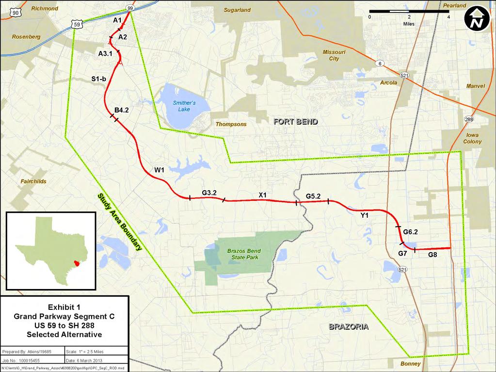
55
56 EXHIBIT 2: Proposed 2035 Toll/HOT Managed Lanes
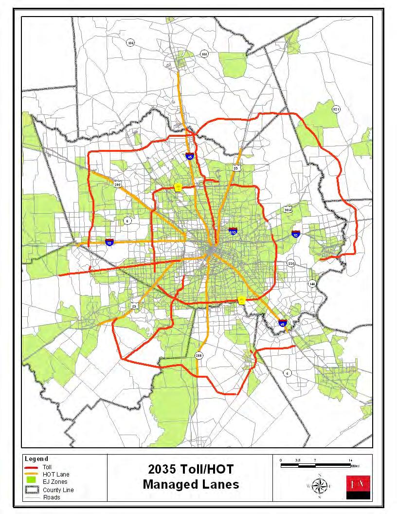
57
58 EXHIBIT 3: Environmental Justice Zones
59
60 EXHIBIT 4: 2035 No Build Regional Managed Lanes
61
U.S. DEPARTMENT OF TRANSPORTATION Federal Highway Administration. RECORD OF DECISION June 2014
 U.S. DEPARTMENT OF TRANSPORTATION Federal Highway Administration RECORD OF DECISION June 2014 Grand Parkway (State Highway 99) Segments H and I-1 From United States Highway (US) 59 North/Interstate Highway
SECONDARY WETLAND IMPACTS ANALYSIS
 SECONDARY WETLAND IMPACTS ANALYSIS USACE File. SWG-2012-00153 During the development of the Grand Parkway (State Highway 99) Segments H and I-1 from United States Highway 59/Interstate Highway 69 N to
Northwest State Route 138 Corridor Improvement Project
 Northwest State Route 138 Corridor Improvement Project Los Angeles County, CA DISTRICT 7- LA- 138 (PM 0.0/36.8); DISTRICT 7- LA- 05 (PM 79.5/83.1); DISTRICT 7- LA- 14 (PM 73.4/74.4) 265100/ 0700001816
Lubbock Outer Route Feasibility Study Report Executive Summary
 Lubbock Outer Route Feasibility Study Report Executive Summary Prepared for: Texas Department of Transportation Lubbock District Prepared by: MACTEC Engineering and Consulting, Inc. 6701 Aberdeen, Suite
This page intentionally left blank.
 Final Environmental Impact Statement: Volume I Grand Parkway (State Highway 99) Segment B: From SH 288 to IH 45 South, Houston District 3510-01-001, 3510-01-003, 3510-02-001, 3510-02-003, 3510-02-004,
Federal Highway Administration FINDING OF NO SIGNIFICANT IMPACT Interstate Highway 45 and Loop 197 Direct Connector Galveston County, Texas
 Federal Highway Administration FINDING OF NO SIGNIFICANT IMPACT Interstate Highway 45 and Loop 197 Direct Connector Galveston County, Texas Introduction The Federal Highway Administration (FHWA) has determined,
D R A F T. SECTION 4(f) EVALUATION. INTERSTATE 73 From I-95 to the Myrtle Beach Region
 EVALUATION. INTERSTATE 73 From I-95 to the Myrtle Beach Region") D R A F T SECTION 4(f) EVALUATION INTERSTATE 73 From I-95 to the Myrtle Beach Region INTRODUCTION Section 4(f) of the Department of Transportation Act of 1966, 49 USC 303 requires that prior to the use
D R A F T SECTION 4(f) EVALUATION INTERSTATE 73 From I-95 to the Myrtle Beach Region INTRODUCTION Section 4(f) of the Department of Transportation Act of 1966, 49 USC 303 requires that prior to the use
PUBLIC HEARING LOOP 9
 PUBLIC HEARING LOOP 9 From Interstate (I)-35E to I-45 Dallas and Ellis Counties, Texas CSJ: Loop 2964-10-005 9: I-35E to I-45 Tuesday, June 20, 20, 2017 2017 Public Hearing Introductions ELECTED & PUBLIC
Grand Parkway State Highway 99 Segment E
 VOLUME II From IH 10 to US 290 Harris County, Texas Final Environmental Impact Statement Grand Parkway State Highway 99 Segment E FHWA-TX-EIS-02-01-F November 2007 Document Organization The Grand Parkway
Draft Environmental Impact Statement
 Draft Environmental Impact Statement North Houston Highway Improvement Project, Houston District From US /I- at Spur to I- at Beltway North CSJ: 0-00- Harris County, Texas April 0 TxDOT will issue a single
University Corridor Draft Environmental Impact Statement (DEIS)
") University Corridor Draft Environmental Impact Statement (DEIS) Public Meetings/Open Houses August 13, 27 August 14, 27 5: pm to 7: pm 5: pm to 7: pm Holiday Inn Select- Greenway* Wheeler Avenue Baptist
University Corridor Draft Environmental Impact Statement (DEIS) Public Meetings/Open Houses August 13, 27 August 14, 27 5: pm to 7: pm 5: pm to 7: pm Holiday Inn Select- Greenway* Wheeler Avenue Baptist
Interstate 73 FEIS: I-95 to the Myrtle Beach Region Chapter 4. Public Involvement and Agency Coordination
 4-65 Interstate 73 FEIS: I-95 to the Myrtle Beach Region 4-66 Comment noted. The use of existing roadways was considered during alternative development (refer to Chapter 2, Section 2.1, page 2-1 and the
Categorical Exclusion (CE)
") Categorical Exclusion (CE) Project Information Project Name: Federal Project#: Project Number: 0029-002-135, D624, P101 Project Type: Construction UPC: 77383 Charge Number: Route Number: 29 Route Type:
Categorical Exclusion (CE) Project Information Project Name: Federal Project#: Project Number: 0029-002-135, D624, P101 Project Type: Construction UPC: 77383 Charge Number: Route Number: 29 Route Type:
Work Breakdown Structure Element Dictionary Preliminary Engineering
 Element Name Initiation PE 3.1 Initiation includes the implementation of the project s funding and notification of the consultant or in-house design staff to commence work, the Kickoff Meeting with the
Texas State Highway 130 Proposed Routes
 Texas State Highway 130 Proposed Routes Submitted by: Mary Magnuson Tom Myatt April 12, 2000 Executive Decision Making Dr. Ernest Forman Table of Contents Executive Summary... 1 Background. 2 Alternatives.
Outer Loop/Rail Bypass Study
 Outer Loop/Rail Bypass Study Outer Loop Stakeholder Roundtable Southwest Segment Joshua City Hall April 16, 2008 North Central Texas Council of Governments Transportation Department Stakeholder Roundtable
Summary. Preliminary Alternative Development and Screening. DEIS July 23, 2018
 What is the Carolina Crossroads Project? The South Carolina Department of Transportation (SCDOT), in cooperation with the Federal Highway Administration (FHWA), is proposing to upgrade and redesign a key
Section 7 Environmental Constraints
 Section 7 Environmental Constraints i Yakima Valley Metropolitan and Regional Transportation Plan Public Comment DRAFT 1/27/2016 Environmental Constraints Analysis A programmatic-level review of potential
I-69 Angelina and Nacogdoches Counties Scoping Study Executive Summary
 I-69 Angelina and Nacogdoches Counties Scoping Study Executive Summary November 2013 The Texas Department of Transportation (TxDOT) is working to find the most appropriate means to develop the Interstate
5.0 PRELIMINARY ENVIRONMENTAL REVIEW
 5.0 PRELIMINARY ENVIRONMENTAL REVIEW 5.1 INTRODUCTION A preliminary environmental review was performed on the proposed freeway improvements that form Concept C, which encompasses the three freeway corridors
Categorical Exclusion Programmatic Agreement Between the Federal Highway Administration And the Indiana Department of Transportation
 Categorical Exclusion Programmatic Agreement Between the Federal Highway Administration And the Indiana Department of Transportation Introduction The Indiana Department of Transportation (INDOT) and the
12 Evaluation of Alternatives
 12 Evaluation of Alternatives This chapter evaluates the effectiveness of the No-Build Alternative and the proposed METRO Blue Line Light Rail Transit (BLRT) Extension project based on the information
An Overview and Comparison of the Tennessee Department of Transportation s Environmental Evaluation Process
 Introduction This document provides a brief overview of the policy and procedures that govern the environmental evaluation process that the Tennessee Department of Transportation (TDOT) must follow for
Abbreviated State Final Environmental Impact Statement
 Loop 375 Border Highway West Extension Project From Racetrack Drive to U.S. Highway 54 El Paso County, Texas CSJ: 2552-04-027 Abbreviated State Final Environmental Impact Statement Texas Department of
Indirect and Cumulative Effects
 Chapter 21: Indirect and Cumulative Effects 21-1 INTRODUCTION The federal Council on Environmental Quality s (CEQ) regulations implementing the procedural provisions of the National Environmental Policy
REEVALUATION FORM. Page 1. Code:
 Page 1 COLORADO DEPARTMENT OF TRANSPORTATION Original NEPA Reevaluation Project Approval Date: Date: Code: REEVALUATION FORM FONSI 9/2004 August 31, 2012 17354 Project Name and Location: Interstate 25,
EXECUTIVE SUMMARY RIVER VALLEY INTERMODAL FACILITIES FINAL ENVIRONMENTAL IMPACT STATEMENT ES-1
 ES.1 INTRODUCTION This Final Environmental Impact Statement (FEIS) for the River Valley Intermodal Facilities (RVIF) in the Arkansas River Valley (ARV) has been written in accordance with the National
APPENDIX H NEPA TRANSITION REPORT
 APPENDIX H NEPA TRANSITION REPORT BORDER HIGHWAY EAST STUDY CSJ: 0-0-00 EL PASO COUNTY, TEXAS TEXAS DEPARTMENT OF TRANSPORTATION The environmental review, consultation, and other actions required by applicable
Purpose of the Public Hearing
 www.virginiadot.org Public Hearings Interstate 66 - Outside the Beltway Tier 1 Draft Environmental Impact Statement From U.S. Route 15 To I-495 Prince William and Fairfax Counties Wednesday, March 13,
DRAFT AIR QUALITY TECHNICAL MEMORANDUM
 AIR QUALITY TECHNICAL MEMORANDUM PROJECT DEVELOPMENT AND ENVIRONMENT STUDY STATE ROAD 60 GRADE SEPARATION OVER CSX RAILROAD Polk County, Florida Financial Project ID: 436559-1-22-01 Prepared for: Florida
Preparing a Reevaluation Using the Documented Reevaluation Checklist (DRC)
") Guidance Preparing a Reevaluation Using the Documented This guidance outlines the TxDOT process for preparing a documented reevaluation as required by 43 TAC 2.85 and 23 CFR 771.129. TxDOT Environmental
Guidance Preparing a Reevaluation Using the Documented This guidance outlines the TxDOT process for preparing a documented reevaluation as required by 43 TAC 2.85 and 23 CFR 771.129. TxDOT Environmental
Categorical Exclusion (CE)
") Categorical Exclusion (CE) Project Information Project Name: Rte 130 Bridge Replacement over Pedlar River Federal Project#: BR-005-3(116) Project Number: 0130-005-643, B650, C501, P101, R201 Project Type:
Categorical Exclusion (CE) Project Information Project Name: Rte 130 Bridge Replacement over Pedlar River Federal Project#: BR-005-3(116) Project Number: 0130-005-643, B650, C501, P101, R201 Project Type:
FEDERAL HIGHWAY ADMINISTRATION RECORD OF DECISION FOR THE LYNNWOOD LINK EXTENSION
 FEDERAL HIGHWAY ADMINISTRATION RECORD OF DECISION FOR THE LYNNWOOD LINK EXTENSION AUGUST 2015 Table of Contents 1 Decision... 1 1.1 Project Description... 2 1.2 Basis for the FHWA Decision... 7 1.2.1
NORTHWEST CORRIDOR PROJECT. NOISE TECHNICAL REPORT 2015 Addendum Phase IV
 Noise Technical Report 2015 Addendum NOISE TECHNICAL REPORT 2015 Addendum PREPARED FOR: Federal Highway Administration and Georgia Department of Transportation PREPARED BY: Parsons Brinckerhoff Project
Table 2.3 Alternatives Considered by the ACT Interstate 73 EIS: I-95 to the Myrtle Beach Region
 Alternative Table 2.3 Alternatives Considered by the ACT 73 EIS: I- to the Region Recommendation 1 Recommended for further study 2 Recommended for further study 3 Eliminated due to having high relocations
Chapter 2: Alternatives
 Chapter 2: Alternatives Introduction An Environmental Impact Statement (EIS) is a procedural document. In other words, the environmental planning process follows a logical sequence of development. Subsequent
APPENDIX A. NEPA Assessment Checklist
 APPENDI A NEPA Assessment Checklist NEPA CHECKLIST DATE: January 12, 2009 PREPARER: Frederick Wells, RLA PIN and Project Title: Surplus Property Request Wilder Balter Partners Marketplace Town of Newburgh,
4 COMMITMENTS 4.1 LAND USE AND LAND COVER
 4 COMMITMENTS Each Affected Environment and Environmental Consequences Subsection contains commitments specific to the impact area being assessed. This section contains a summary of the commitments that
Welcome. Public Meeting. August 2, :00 to 7:00 p.m. Presentation 6:00 to 6:30 p.m.
 Welcome Public Meeting August 2, 2017 5:00 to 7:00 p.m. Presentation 6:00 to 6:30 p.m. www.glenwoodsouthbridge.net Welcome to the South Bridge Environmental Assessment Public Meeting Why Are We Here Tonight?
SUMMARY S.1 PROJECT DESCRIPTION AND LOCATION S.2 PURPOSE AND NEED
 S SUMMARY S.1 PROJECT DESCRIPTION AND LOCATION The Virginia Department of Transportation (VDOT), in cooperation with the Federal Highway Administration (FHWA), is studying alternatives to meet transportation
Oklahoma Department of Transportation Environmental Programs Division Office Fax
 Oklahoma Department of Transportation Environmental Programs Division Office 521-3050 Fax 522-5193 Documented Categorical Exclusion (DCE) for I-40: Pavement Reconstruction and Added Lanes from the Douglas
TIER 2 EIS SCOPING MEETING WELCOME TO THE FEDERAL AVIATION ADMINISTRATION SCOPING MEETING
 TIER 2 EIS SCOPING MEETING WELCOME TO THE FEDERAL AVIATION ADMINISTRATION SCOPING MEETING TIER 2 EIS OVERVIEW SOUTH SUBURBAN INAUGURAL AIRPORT ENVIRONMENTAL IMPACT STATEMENT The proposed, (SSA) will require
PUBLIC HEARING US 69 WIDENING. Phase 1 (IH-10 to LNVA Canal) Phase 2 (LNVA Canal to Tram Road) Jefferson County, Texas
 Phase 2 (LNVA Canal to Tram Road) Jefferson County, Texas") PUBLIC HEARING US 69 WIDENING Phase 1 (IH-10 to LNVA Canal) Phase 2 (LNVA Canal to Tram Road) Jefferson County, Texas CSJs: 0065-07-062 and 0200-11-095 Footer Text Thursday, April 26, 2018 Date ELECTED
PUBLIC HEARING US 69 WIDENING Phase 1 (IH-10 to LNVA Canal) Phase 2 (LNVA Canal to Tram Road) Jefferson County, Texas CSJs: 0065-07-062 and 0200-11-095 Footer Text Thursday, April 26, 2018 Date ELECTED
Initial Alternative One: No Build
 Initial Alternatives The first steps in the ultimate selection of a Most Feasible Alternative the transportation improvements along the SH 288 corridor that make best meet the study goals - is the conceptual
vi Figures viii Summary S.1
 Contents Contents iii Tables vi Figures viii Summary S.1 Chapter 1: Purpose and Need Project History A.1 Project Description A.2 Project Purpose A.5 Transportation Need A.6 Highway Capacity and Congestion
Environmental Impact Statement; Lone Star Regional Rail Project Williamson, Travis, Bastrop, Hays, Caldwell, Comal, Guadalupe, and Bexar Counties, TX
 This document is scheduled to be published in the Federal Register on 10/06/2014 and available online at http://federalregister.gov/a/2014-23711, and on FDsys.gov [4910-22] DEPARTMENT OF TRANSPORTATION
FEDERAL HIGHWAY ADMINISTRATION FINDING OF NO SIGNIFICANT IMPACT
 FEDERAL HIGHWAY ADMINISTRATION FINDING OF NO SIGNIFICANT IMPACT FM 1093/Westpark Tollway: From FM 1463/FM 359 to SH 99 (Grand Parkway) Fort Bend County, Texas CSJs: 1258-03-042 and 1258-03-043 INTRODUCTION
PURPOSE OF THE TRANSPORTATION IMPROVEMENT PROGRAM (TIP)
") INTRODUCTION PURPOSE OF THE TRANSPORTATION IMPROVEMENT PROGRAM (TIP) The Transportation Improvement program (TIP) is a staged, four-year program of projects proposed for funding by federal, State, and
INTRODUCTION PURPOSE OF THE TRANSPORTATION IMPROVEMENT PROGRAM (TIP) The Transportation Improvement program (TIP) is a staged, four-year program of projects proposed for funding by federal, State, and
DRAFT. Draft Carbon Monoxide (CO) Traffic Air Quality Analysis
 Traffic Air Quality Analysis") Draft Carbon Monoxide (CO) Traffic Air Quality Analysis North Houston Highway Improvement Project From US 59/I-69 at Spur 527 To I-45 at Beltway 8 North Harris County TxDOT Houston District CSJ: 0912-00-146
Draft Carbon Monoxide (CO) Traffic Air Quality Analysis North Houston Highway Improvement Project From US 59/I-69 at Spur 527 To I-45 at Beltway 8 North Harris County TxDOT Houston District CSJ: 0912-00-146
AGENCY MEETING. I-10E Planning & Environmental Linkages Meeting #1 TxDOT Houston District
 AGENCY MEETING I-10E Planning & Environmental Linkages Meeting #1 TxDOT Houston District January 25, 2018 WELCOME TxDOT Project Manager: Grant Chim, P.E. Agenda 1 Introductions / Purpose of Meeting 2 What
MEMORANDUM. Date: July 14, 2006 Project #: To: US 97 & US 20 Refinement Plan Steering Committee
 MEMORANDUM Date: July 14, 2006 Project #: 6389 To: US 97 & US 20 Refinement Plan Steering Committee From: Sonia Hennum, P.E., Andrew Cibor, E.I.T., & Julia Kuhn, P.E. Project: US 97 & US 20 Refinement
11 Joint Development Regulatory Context and Methodology
 11 Joint Development This chapter describes the long-term direct and potential indirect impacts, and short-term direct and potential indirect impacts, of the proposed METRO Blue Line Light Rail Transit
SH 34 Corridor Study & Environmental Assessment:
 SH & Environmental Page 1 SH & Environmental : from Kaufman (SH 243) to Terrell (north of IH 20) Third Series TxDOT 80 557 80 The SH Corridor 20 20 175 SH Study Area Boundary 243 175 SH & Environmental
Objective A: Transportation facilities and services should be designed to conform with other policies contained herein.
 CHAPTER ONE GOALS & OBJECTIVES INTRODUCTION KRS 100.193 mandates that a Planning Commission adopt statements of goals and objectives that will act as guides to the preparation of the plan. The update has
Business Advisory Committee. July 12, 2016
 Business Advisory Committee July 12, 2016 1 Today s Topics Approval of Meeting Minutes Cost Participation Adjusted Project Scope and Cost Estimate Recommendation Environmental Update 2 3 Cost Participation
Interstate 66 Tier 1 Environmental Impact Statement Public Hearing
 Interstate 66 Tier 1 Environmental Impact Statement Public Hearing 1 Project Corridor Study Process / Tiering Approach Tier 1 EIS focuses on broad issues - Purpose and need - Mode / Technology choice -
Lynnwood Link Extension 2013 Draft EIS Comments and Responses
 Page 157 C-001-001 Sound Transit acknowledges your opposition to Alternative C1 due to its residential impacts and impacts to Scriber Creek Park and wetlands. Page 158 C-002-001 Following the Draft EIS,
APPROVAL TO SUBMIT COMMENTS ON I-45 AND MORE DRAFT ENVIRONMENTAL IMPACT STATEMENT
 TAC Agenda Item 09 Mailout 7/12/17 APPROVAL TO SUBMIT COMMENTS ON I-45 AND MORE DRAFT ENVIRONMENTAL IMPACT STATEMENT Background The Texas Department of Transportation, in cooperation with the Federal Highway
FINDINGS OF FACT And CONCLUSIONS
 FINDINGS OF FACT And CONCLUSIONS SOUTHWEST RECONNECTION PROJECT Highway 61/101 Flood Mitigation State Project No. 1009-24 and State Aid Project No. 010-661-002 Prepared for: Carver County September 2013
Table Table 7.2 Potential Environmental Impacts and Mitigation Measures
 7.2 Natural Environment/Environmental Planning Executive Summary/Key Points The Environmental Consultation and Mitigation Plan establishes: o A process for consultation with environmental resource agencies
Programmatic Categorical Exclusions
 Memorandum of Agreement for Approval of Categorical Exclusions between the Federal Highway Administration and the Wyoming Department of Transportation. February 12, 2014 The Federal Highway Administration,
Appendix. Sample EA/EIS Scope of Work
 Appendix K Sample EA/EIS Scope of Work EA/EIS Sample Scope of Work The purpose of this Scope of Work (SOW) is to prepare an EA document pursuant to the National Environmental Policy Act (NEPA) to analyze
5. Other Environmental Consequences
 5. Other Environmental Consequences 5.1 Unavoidable Adverse Impacts Impacts to the following environmental resources were evaluated for Alternative D, the preferred alternative, to determine if they would
Chapter 3 FEDERAL POLICIES SOUTH DAKOTA DRAINAGE MANUAL
 Chapter 3 FEDERAL POLICIES SOUTH DAKOTA DRAINAGE MANUAL October 2011 Table of Contents Section Page 3.1 ENVIRONMENTAL...3-1 3.2 HEALTH...3-3 3.3 HISTORIC AND ARCHEOLOGICAL PRESERVATION...3-4 3.4 LAND
Evaluation of Alternatives
 Chapter 9.0 Evaluation of Alternatives Chapter 9.0 provides a summary evaluation of the No Build Alternative and the Preferred Alternative. The evaluation contained within this chapter is an assessment
3. ALTERNATIVES ANALYSIS
 3. ALTERNATIVES ANALYSIS As described in the following sections, preliminary concepts were developed and screened. Following three rounds of screening, the remaining concepts were developed into alternatives
CHAPTER 5: INDIRECT IMPACTS TABLE OF CONTENTS
 CHAPTER : INDIRECT IMPACTS TABLE OF CONTENTS. Methodology... -.. Stakeholder and Expert Panel Involvement... -. Step : Scoping... -. Step : Identify the Study Area s Goals & Trends... -.. Study Area Goals...
5.0 LONG-TERM CEQA CONSIDERATIONS
 5.0 LONG-TERM CEQA CONSIDERATIONS Section 15126 of the CEQA Guidelines requires that all phases of a project must be considered when evaluating its impact on the environment, including planning, acquisition,
PROGRAMMATIC AGREEMENT
 PROGRAMMATIC AGREEMENT CATEGORICAL EXCLUSION APPROVALS NEW HAMPSHIRE DEPARTMENT OF TRANSPORTATION & FEDERAL HIGHWAY ADMINISTRATION FEBRUARY 2000 PREAMBLE This Agreement establishes the procedures of the
HIGHWAY 412 EXECUTIVEXECUTIVE SUMMARYUMMARY FINAL ENVIRONMENTAL IMPACT STATEMENT. Benton and Washington Counties. October 2005
 EXECUTIVEXECUTIVE SUMMARYUMMARY FINAL ENVIRONMENTAL IMPACT STATEMENT SPRINGDALE NORTHERN BYPASS HIGHWAY 412 Benton and Washington Counties October 2005 Federal Highway Administration Arkansas State Highway
US 377 CRESSON RELIEF ROUTE
 US 377 CRESSON RELIEF ROUTE Public Hearing Tuesday, February 25, 2014 CSJ: 0080-11-001 and 0080-12-001 US 377 Cresson Relief Route Project Location Proposed US 377 Existing US 377 Cresson 2 Public Hearing
Lynnwood Link Extension 2013 Draft EIS Comments and Responses. Page 945
 I-441-001 Thank you for your comments about the importance of the Latvian Center to the Latvian community. Following the Draft EIS, the Sound Transit Board directed Sound Transit to develop a Preferred
Draft Final Report HOUSTON FRIENDSWOOD HARRIS CO. GALVESTON CO. Figure. Arterial. RR Tracks. County Line
 Draft Final Report 1.0 Introduction The Houston metropolitan region, consisting of the eight-county area of Harris, Galveston and surrounding counties, represents the fourth largest city in the United
NEPA and Design Public Hearings
 NEPA and Design Public Hearings Monday, December 5, 2016 Washington-Lee High School 1301 N. Stafford Street Arlington, VA 22201 Thursday, December 8, 2016 Mary Ellen Henderson Middle School 7130 Leesburg
RESOLUTION NO:
 RESOLUTION NO: 11-031 A RESOLUTION OF THE CITY COUNCIL OF THE CITY OF PASO ROBLES CERTIFYING THE FINAL ENVIRONMENTAL IMPACT REPORT FOR THE 2011 CIRCULATION ELEMENT OF THE GENERAL PLAN AND ADOPTING FINDINGS,
State Route 8 Bridge Replacement Project
 OPEN HOUSE PUBLIC INVOLVEMENT MEETING Celebration Church 688 Dan Street, Akron, Ohio Tuesday, July 14, 2015 5:00 PM to 7:00 PM State Route 8 Bridge Replacement Project Existing Bridge Future Bridges: Steel
2.1.1 Traffic Noise Analysis
 2.1.1 Traffic Noise Analysis Number: 2.1.1 2.1.1 Name: Traffic Noise Analysis Traffic Noise Analysis Description: This category includes the performance of a traffic This category includes the performance
6.1 Introduction. 6.2 Consultation and Requirements Federal Endangered Species Act. Chapter 6 Consultation and Coordination
 Chapter 6 Consultation and Coordination 6.1 Introduction This chapter provides an overview of consultation, other requirements, and the scoping process and public involvement process for the proposed HCP/NCCP.
Executive Summary. Milestones and Background
 Executive Summary Milestones and Background On January 25 and February 1, 2011 respectively, the Federal Highway Administration certified that the Houston- Galveston area s 2035 Regional Transportation
ROUTE FEASIBILITY STUDY. PUBLIC MEETING January 26, 2010
 PHASE I - LUBBOCK OUTER ROUTE FEASIBILITY STUDY PUBLIC MEETING January 26, 2010 CONSTRUCTION SCHEMATIC DESIGN & ENVIRONMENTAL STUDY DETAILED DESIGN & RIGHT OF WAY ACQUISITION UTILITY ADJUSTMENTS ROUTE
Woodlake General Plan Draft Environmental Impact Report
 5.0 UNAVOIDABLE ADVERSE ENVIRONMENTAL EFFECTS The following potential adverse environmental effects appear to be unavoidable if the Woodlake General Plan is implemented, even if certain mitigation measures
Environme ntal Assessment Addendum
 FI Improved Interchange at I-71 and Routes 36/37 and Proposed Sunbury Parkway Environme ntal Assessment Addendum DEL-71-7.91 PID 90200 September 20, 2017 The environmental review, consultation, and other
RESOLUTION NO
 RESOLUTION NO. 2018-12 RESOLUTION OF THE SOUTHEASTERN WISCONSIN REGIONAL PLANNING COMMISSION AMENDING THE TRANSPORTATION IMPROVEMENT PROGRAM FOR SOUTHEASTERN WISCONSIN: 2017-2020 WHEREAS, the Southeastern
IH 30/IH 35E Reconstruction Project Pegasus Final Technical Memorandum - Evaluation of Conceptual Alternatives Task 7.5
 MEMO TO: Timothy Nesbitt, P.E. DATE: August 26, 2002 FROM: SUBJECT: Sandy Wesch-Schulze, P.E., AICP IH 30/IH 35E Reconstruction Project Pegasus Final Technical Memorandum - Evaluation of Conceptual Alternatives
SECTION 6.0 Alternatives to the Proposed Project
 SECTION 6.0 Alternatives to the Proposed Project 6.0 ALTERNATIVES TO THE PROPOSED PROJECT CEQA requires that an EIR include an analysis of a range of project alternatives that could feasibly attain most
ENVIRONMENTAL ASSESSMENT
 ENVIRONMENTAL ASSESSMENT Section 408 Request to Alter the Dubois Local Protection Project for the Beaver Drive sidewalk construction in Clearfield County, PA June 28, 2018 Prepared By: Environmental and
Letter to Ms. Wallace. March 24, 2014
 March 24, 2014 1 FIGURE 1 2 FIGURE 2 Project Limits 3 CE Provisions Relative to the Project Pursuant to the provisions of 23 CFR 771.118(d), (or d-list), the Federal Highway Administration (FHWA) and FTA
SECTION 10: WETLANDS PROTECTION
 SECTION 10: WETLANDS PROTECTION 10-1 INTENT AND PURPOSE A. Intent 1. The City finds that wetlands serve a variety of beneficial functions. Wetlands maintain water quality, reduce flooding and erosion,
TIER 1 DRAFT ENVIRONMENTAL IMPACT STATEMENT. 7. Affected Environment, Environmental Consequences, and Mitigation Strategies
 TIER 1 DRAFT ENVIRONMENTAL IMPACT STATEMENT 7. Affected Environment, Environmental Consequences, and Mitigation Strategies Table of Contents Chapter 7 7 Affected Environment, Environmental Consequences,
1. Introduction Noise Analysis Results Figures. List of Tables
 Traffic Noise Technical Report FM 2218 Widening (From US 59 to SH 36) Fort Bend County Prepared by: Houston District Date: July 2017 CSJ: 2093-01-010 The environmental review, consultation, and other actions
6.0 Indirect Effects and Cumulative Impacts
 6.0 Effects and Impacts 6.1 Introduction This chapter of the Draft EIS addresses potential indirect and cumulative impacts of the Bottineau Transitway project. effects are those that are caused by the
On behalf of the Carolina Crossroads project team we thank you for taking the time to attend this meeting.
 On behalf of the Carolina Crossroads project team we thank you for taking the time to attend this meeting. Located in the heart of South Carolina, the I-20/26/126 Corridor is the crossroads of the state
Public Hearing 2. Highway/Limits SH 121: From IH 30 to FM 1187 CSJ
 Public Hearing ( and Response to Comments Received at and Subsequent to the December 13, 2004 Public Hearing) District/County Fort Worth District/ Tarrant County Highway/Limits SH 121: From IH 30 to FM
SUPPLEMENTAL DRAFT ENVIRONMENTAL IMPACT STATEMENT NORTH BELT FREEWAY SUMMARY INTRODUCTION
 SUMMARY INTRODUCTION The Arkansas State Highway and Transportation Department (AHTD), in cooperation with the Federal Highway Administration (FHWA), is proposing a highway project located in northern Pulaski
Categorical Exclusion (CE)
") Categorical Exclusion (CE) Project Information Project Name: I-66 ITB West Falls Church Metro Garage Access Federal Project#: NHPP-066-1(356) Project Number: 0066-96A-493, B686, C501, P101 Project Type:
Categorical Exclusion (CE) Project Information Project Name: I-66 ITB West Falls Church Metro Garage Access Federal Project#: NHPP-066-1(356) Project Number: 0066-96A-493, B686, C501, P101 Project Type:
Northern Branch Corridor CLC Meeting. June 30, 2008
 Northern Branch Corridor CLC Meeting June 30, 2008 Agenda Introductions Project Status Environmental Process Technical Findings Capital Costs Next Steps Break Out Areas Introductions Project Status Preliminary
16.1 Significant and Unavoidable Impacts
 Chapter 16 NEPA requires an EIS and CEQA requires an EIR to evaluate a number of other types of environmental impacts in addition to those already addressed in the resource chapters. The analysis required
Public Notice. Applicant: City of Dallas Project No.: SWF Date: April 18, Name: Chandler Peter Phone Number:
 Public Notice Applicant: City of Dallas Project No.: SWF- 2014-00151 Date: April 18, 2014 The purpose of this public notice is to inform you of a proposal for work in which you might be interested. It
SOUTHWEST LRT (METRO GREEN LINE EXTENSION)
") 8 Evaluation of Alternatives This chapter evaluates the effectiveness of the No Build Alternative and the Southwest Light Rail Transit (LRT) Project (the Project) based on the information contained in
8 Evaluation of Alternatives This chapter evaluates the effectiveness of the No Build Alternative and the Southwest Light Rail Transit (LRT) Project (the Project) based on the information contained in
181 State Road 415, New Smyrna Beach. Railey Harding & Allen, P.A. Barcelo Developments, Inc. Scott Ashley, AICP, Planning Manager
 GROWTH AND RESOURCE MANAGEMENT DEPARTMENT PLANNING AND DEVELOPMENT SERVICES DIVISION CURRENT PLANNING ACTIVITY 123 W. Indiana Avenue, Room 202, DeLand, FL 32720 (386) 943-7059 PUBLIC HEARING: CASE NO: