Columbia Regional Airport (COU) Columbia, Missouri. Draft Environmental Assessment Airside, Landside, and Surface Transportation Developments
|
|
|
- Camron Preston
- 6 years ago
- Views:
Transcription


1 (COU) Columbia, Missouri Draft Environmental Assessment Airside, Landside, and Surface Transportation Developments RS&H No Prepared for the: City of Columbia and U.S. Department of Transportation - Federal Aviation Administration Prepared by: Deerwood Park Boulevard South Jacksonville, Fl January 2012
2 (COU) Columbia, Missouri ENVIRONMENTAL ASSESSMENT (EA) FOR The Proposed Action, assessed for potential environmental impacts within this EA, includes an 899-foot extension of Runway 2/20 for a total runway length of 7,400 feet. This extension would result in the need to extend parallel Taxiway A, acquire 52 acres of land for the associated runway protection zone and navigational aids, and relocate a segment of Route H. The Proposed Action also includes the relocation of runway pavement and 1,099-foot extension of Runway 13/31 for a total length of 5,500 feet. This component would result in extending parallel Taxiway B and realigning a segment of South Rangeline Road. In addition, other airside and landside components of the Proposed Action include: the rehabilitation or reconstruction of airfield pavement, construction of connector Taxiway A5, widening of Taxiway A4, rehabilitating the south apron area, expanding the apron between Taxiways A2 and A3, infield drainage improvements, and expanding the auto parking lot. Prepared by:, Inc. For: City of Columbia This environmental assessment becomes a Federal document when evaluated, signed, and dated by the responsible Federal Aviation Administration (FAA) Official. Responsible FAA Official Date
3 Table of Contents TABLE OF CONTENTS Section TABLE OF CONTENTS ACRONYMS Page i vi 1. PURPOSE AND NEED 1.1 Background of the Proposed Action Need for Proposed Action Purpose of the Proposed Action Forecast Data Requested Federal Action Organization of this EA ALTERNATIVES 2.1 Introduction Alternatives Evaluation Process Alternatives Considered Screening Criteria No-Action Alternative Preferred Alternative AFFECTED ENVIRONMENT 3.1 Introduction Resources Not Affected Resources Potentially Affected Past, Present, and Reasonably Foreseeable Future Actions Location Map, Vicinity Map, ALP Existing/Planned Land Uses and Zoning Affected Political Jurisdiction Demographics ENVIRONMENTAL CONSEQUENCES AND MITIGATION 4.0 Introduction Air Quality Coastal Resources Compatible Land Use Construction Impacts Department of Transportation Act: Section 4(f) Farmlands Fish, Wildlife, and Plants Floodplains Hazardous Materials, Pollution Prevention, and Solid Waste Historic, Architectural, Archaeological, and Cultural Resources Light Emissions and Visual Impacts Natural Resources, Energy Supply, and Sustainable Design Noise Secondary (Induced) Impacts Socioeconomic Impacts, Environmental Justice, and Children s Environmental Health and Safety 4-38 Environmental Assessment i January 2012
4 Table of Contents 4.16 Water Quality Wetlands Wild and Scenic Rivers CUMULATIVE IMPACT ANALYSIS 5.1 Regulatory Context Threshold of Significance Methodology Cumulative Impacts Summary REFERENCES GLOSSARY 7-1 Environmental Assessment ii January 2012
5 Table of Contents LIST OF FIGURES CHAPTER 1 Page Figure 1-1 Project Location 1-2 Figure 1-2 Airport Layout Plan 1-3 Figure 1-3 Priority Sequence of Airfield Rehabilitation 1-5 Figure 1-4 Safety Issues at the Runway Intersection 1-6 Figure 1-5 Proposed Action 1-11 CHAPTER 2 Figure 2-1 Alternatives Considered 2-4 Figure 2-2 Alternatives 1G and 2F 2-6 Figure 2-3 Alternative 2Ga 2-8 Figure 2-4 Alternative 2Gb 2-9 CHAPTER 3 Figure 3-1 Airport Study Area 3-2 Figure 3-2 Section 4(f) Resources in the Airport Vicinity 3-4 Figure 3-3 Bonne Femme Karst COA 3-6 Figure 3-4 Floodplains in the Airport Vicinity 3-7 Figure 3-5 Existing Farmland Designations within the Airport Study Area 3-11 Figure 3-6 Existing Condition Noise Contours 3-17 Figure 3-7 Intermittent Water Bodies and Creeks in the Airport Vicinity 3-20 Figure 3-8 NWI Resources in the Airport Vicinity 3-21 Figure 3-9 Location and Vicinity Map 3-24 Figure 3-10 Airport Layout Plan Existing Conditions 3-25 Figure 3-11 Unincorporated Boone County Existing and Planned Land Use in the Airport Vicinity 3-26 Figure 3-12 City of Ashland Existing Land Use 3-28 Figure 3-13 City of Ashland 10-Year land Use Plan 3-29 CHAPTER 4 Figure 4-1 Land Acquisition 4-5 Figure 4-2 Farmland Impacts 4-13 Figure 4-3 Biological Resources Survey Study Sites 4-16 Figure 4-4 Area of Potential Effect 4-24 Figure 4-5 Proposed Runway 20 Approach, Lighting, and Navigational Equipment 4-27 Figure 4-6 Proposed Runway 31 Approach Lighting, and Navigational Equipment 4-28 Figure 4-7 Future No-Action Alternative Noise Contours 4-35 Figure 4-8 Future Proposed Action Noise Contours 4-36 Figure 4-9 Comparison of Future No-Action Alternative and Proposed Action Noise Contours 4-37 Figure 4-10 South Rangeline Road Realignment 4-41 Figure 4-11 Route H Realignment 4-42 Figure 4-12 NWI Resources Affected by Implementation of the Proposed Action 4-47 Environmental Assessment iii January 2012
6 Table of Contents LIST OF TABLES CHAPTER 1 Page Table 1-1 Proposed Action Construction Schedule 1-12 Table 1-2 Forecast Summary 1-13 CHAPTER 2 Table 2-1 Evaluation of Alternatives 2-13 CHAPTER 3 Table 3-1 Air Quality Data of the Nearest Monitoring Station to the Airport 3-1 Table 3-2 Attainment Status for the Columbia Region 3-3 Table 3-3 Section 4(f) Resources in the Airport Vicinity 3-4 Table 3-4 Existing Soil Classes in the Airport Study Area 3-10 Table 3-5 Flora Encountered in the Airport Study Area 3-12 Table 3-6 Potentially Threatened or Endangered Species in Boone County, Missouri 3-13 Table 3-7 NRHP-Listed Resources Closest to the Airport 3-15 Table 3-8 Community Characteristics 3-31 Table 3-9 Unemployment Rates National, State and Regional 3-32 Table 3-10 Per Capita Income National, State and Regional 3-32 CHAPTER 4 Table 4-1 Acreage of Farmland Impacts of the Proposed Action 4-12 Table 4-2 Changes in Impervious Surface Associated with Implementation of the Proposed Action 4-19 Table 4-3 Additional Stormwater Volumes Associated with Implementation of the Proposed Action 4-20 Table 4-4 No-Action and Proposed Action Taxi Distances 4-31 Table 4-5 Acreage Comparison of Future Noise Contours 4-34 CHAPTER 7 Table 7-1 Airport Reference Code 7-2 Environmental Assessment iv January 2012
7 Table of Contents APPENDICES Appendix A: Preparer and Qualifications Appendix B: Agencies Consulted Appendix B-1: Agencies Consulted During the Master Planning Process Appendix B-2: Tribal Coordination Appendix C: People Consulted Appendix D: Sponsor Land Use Assurance Letter Appendix E: Aviation Forecasts Appendix F: Historic (Section 106) Appendix G: Biological Resources Appendix H: Farmlands (Form AD-1006) Environmental Assessment v January 2012
8 Acronyms ACRONYMS A-1 - Agricultural zoning used in Boone County A-2 - Urban Agriculture zoning category used in Boone County AC Advisory Circular ACHP Advisory Council on Historic Preservation ALP Airport Layout Plan ALS Approach Lighting System ALSF Approach Lighting with Sequenced Flashing Lights APE - Area of Potential Effect ARC - Airport Reference Code ARFF Airport Rescue and Fire Fighting ATCT - Air Traffic Control Tower BCFPD - Boone County Fire Protection District BMPs Best Management Practices BREA Baskett Wildlife Research and Education Area CAA - Clean Air Act CEQ Council on Environmental Quality CERCLA Comprehensive Environmental Response, Compensation, and Liability Act CFR Code of Federal Regulations CIP Capital Improvement Plan City - City of Columbia CO Carbon Monoxide COA Conservation Opportunity Area COU (Airport Code) CUP Conditional Use Permit CWA - Clean Water Act CZMA - Coastal Zone Management Act CZMP Coastal Zone Management Plan Db Decibel DNL Day-Night Average Sound Level DOT Department of Transportation EJ Environmental Justice Enplanement A passenger boarding of a flight. EO Executive Order EPA - Environmental Protection Agency ESA Endangered Species Act ESRI Environmental Systems Research Institute FAA Federal Aviation Administration FBO Fixed Base Operator FEMA Federal Emergency Management Agency FIRM Flood Insurance Rate Map. FPPA Farmland Protection Policy Act FWCA Fish and Wildlife Coordination Act GIS Geographic Information System GA - General Aviation GPS Global Positioning System HIRL - High Intensity Runway Lights ILS Instrument Landing System INM Integrated Noise Model Environmental Assessment vi January 2012
9 Acronyms LOS Level of Service LWCF - Land and Water Conservation Fund Act LOS Level of Service MALSF Medium Intensity Approach Lighting System with Sequenced Flashing MALSR - Medium Intensity Approach Lighting System MBTA Migratory Bird Treaty Act MDC - Missouri Department of Conservation MDNR Missouri Department of Natural Resources MIRL Medium Intensity Runway Lights MITL Medium Intensity Taxiway Lighting MOA - Memorandum of Agreement MoDOT Missouri Department of Transportation MOU Memorandum of Understanding MPO Metropolitan Planning Organization MSL Mean Seal Level NAAQS - National Ambient Air Quality Standards NAVAID Navigational Aid NHPA National Historic Preservation Act NRHP National Register of Historic Places MDNR - Missouri Department of Natural Resources MSW - Municipal Solid Waste MTNF Mark Twain National Forest NAAQS National Ambient Air Quality Standards NEM Noise Expose Map NEPA - National Environmental Policy Act NHPA - National Historic Preservation Act NMFS - National Marine Fisheries Service NO Nitric Oxide NOAA National Oceanic and Atmospheric Administration NOx Nitrogen Oxides NOI Notice of Intent NPDES National Pollutant Discharge Elimination System NPI Non Precision NPIAS - National Plan of Integrated Airports System NPL National Priority List NPS Non Point Source NPS - National Park Service NRC - National Response Center NRCS Natural Resource Conservation Service NRHP National Register for Historic Places NRI - Nationwide Rivers Inventory NWI - National Wetlands Inventory O 3 - Ozone ODALS - Omni-Directional Approach Lighting System OFA Object Free Area OFZ Obstacle Free Zone Pb - Lead PCI - Pavement Condition Index; or PCI Per Capita Income PCS - Permit Compliance System PPM Parts Per Million Environmental Assessment vii January 2012
10 Acronyms RNAV Area Navigation RAILS Runway Alignment Indicator Light System Ramp See Apron RCRA Resource Conservation and Recovery Act REIL Runway End Identifier Lights RNAV - Area Navigation RPZ Runway Protection Zone RSA Runway Safety Area RVZ - Runway Visibility Zone SDWA Safe Drinking Water Act SHPO State historic preservation Officer SIP - State Implementation Plan SO 2 Sulfur dioxide SRE Snow Removal Equipment SWPPP - Stormwater Pollution Prevention Plan TAF Terminal Area Forecast TDAT - Tribal Directory Assessment Tool THPO Tribal Historic Preservation Officer TMDL Total Maximum Daily Load TODA - Takeoff distance Available TPY - Tons Per Year USACE United States Army Core of Engineers USC United States Code USDA United States Department of Agriculture USFWS United States Fish and Wildlife Service USGS United States Geological Survey UST Underground Storage Tank VASI Visual Approach Slope Indicator VGSI - Visual Guidance Slope Indicator VMT Vehicle Miles Traveled VOCs - Volatile Organic Compounds WSRS - National Wild and Scenic Rivers System WWTF Wastewater Treatment Facility WWTP Wastewater Treatment Plant Environmental Assessment viii January 2012
11 Chapter 1 Purpose and Need PURPOSE AND NEED This Environmental Assessment (EA) is prepared to comply with the requirements of the National Environmental Policy Act (NEPA). This EA complies with the guidance set forth in the Federal Aviation Administration (FAA) Order B, 1 FAA Order E, Change 1, 2 as well as the FAA Environmental Desk Reference for Airport Actions, applicable Executive Orders, Council on Environmental Quality (CEQ) regulations, and other Federal, State and local legislation. In September 2009, an Airport Master Plan Update was completed that assessed the future facility needs of the (Airport) over a 20-year implementation schedule. Subsequent to the completion of the 2009 Airport Master Plan Update, but during the FAA review and approval period, a Supplemental Study was undertaken to address the impact of improved commercial airline service at the Airport. 3 The 2009 Airport Master Plan Update and Supplemental Study document needed facility improvements, identify the preferred improvement option, and establish project priorities, schedules, and costs. The 2009 Airport Master Plan Update, Supplemental Study and all accompanying technical reports serve as the foundation for this EA. 1.1 BACKGROUND AND EXISTING FACILITY The Airport is identified in the FAA s National Plan of Integrated Airports System (NPIAS) as a primary non-hub airport. 4 The Airport is located outside the City of Columbia, Missouri in Boone County, approximately 10 miles southeast of downtown Columbia and approximately 2.5 miles northeast of the Town of Ashland (see Figure 1-1). Primary access to the Airport is via U.S. 63 and Route H from the west, Rangeline Road from the east, Angel Lane from the south, and South Airport Drive, which connects these roadways to the Airport. The Airport is owned and operated by the City of Columbia (City), which is led by a six-member city council; headed by the elected Mayor of Columbia and an appointed City Manager. The Airport is a division within the City s Public Works Department and the Airport Division is responsible for the management and operation of the Airport. A full-time professional Airport Manager serves as the day-to-day director of the Airport. This position is appointed by the Director of Public Works. A 13-member Airport Advisory Board consists of members from the surrounding communities and local businesses, seven of which are appointed by the City Council. The Airport Advisory Board provides input to the Airport Manager and the City Council regarding matters at the Airport. 1 Federal Aviation Administration, Order B, National Environmental Policy Act (NEPA) Implementing Instructions for Airport Actions, April 26, Federal Aviation Administration, Order E, Change 1, Environmental Impacts: Policies and Procedures, Change 1, March 20, , Memorandum to Andrew Schneider, COU Airport Manager, Runway Supplemental Runway Report, July 14, Federal Aviation Administration, National Plan of Integrated Airports System. Available at: Accessed: February Environmental Assessment 1-1 January 2012

12 Chapter 1 Purpose and Need Figure 1-1 PROJECT LOCATION SOURCE: ESRI; Boone County Assessor's Office; RS&H, 2011 PREPARED BY: RS&H, Existing Facility The Airport is a public-use commercial service airport, offering facilities for use by commercial, general aviation and military traffic. The general configuration of the Airport, along with the location of major facility and infrastructure is depicted on Figure 1-2. The airfield includes a system of runways, taxiways, navigational/lighting aids and imaginary airspace surfaces used to accommodate the landing and takeoff of aircraft. The airfield is supported by a terminal area located along the west side of the airfield. The terminal area accommodates various aviation uses and supports other non-aeronautical functions. The terminal area consists of aircraft parking apron, a variety of associated buildings including a passenger terminal, a number of aircraft hangars, support buildings and auto parking lots. The airfield has two intersecting runways, the north-south primary Runway 2/20 is 6,501 by 150 feet, and the east-west crosswind Runway 13/31 is 4,401 by 75 feet. Both runways are lighted, have straight-in instrument approach procedures, and are served by full-length parallel taxiway systems. Environmental Assessment 1-2 January 2012

13 Chapter 1 Purpose and Need Figure 1-2 EXISTING AIRPORT LAYOUT PLAN Environmental Assessment 1-3 January 2012
14 Chapter 1 Purpose and Need Runway 2/20 is a Category C-III runway, accommodating large-cabin business jets, which are the critical aircraft group for the Airport. This includes the Gulfstream-400/450 Series and Bombardier Global Express. Narrow-body transports (e.g., Airbus 320/321, Boeing727, Boeing737, McDonnell Douglas DC-9/ MD-80, Boeing757) also currently operate on Runway 2/20. The crosswind runway is a Category B-II asphalt runway accommodating smaller aircraft such as piston and turboprop aircraft. The existing critical aircraft for Runway 13/31 is the King Air C90. The crosswind runway does not have the capability to handle all Airport operations during an event that the primary runway would be closed. The taxiway system consists of Taxiway A (parallel to Runway 2/20) which is 6,501 feet in length, Taxiway B (parallel to Runway 13/31) which is 4,401 feet in length. The taxiway system also includes connector taxiways A1, A2, A3, A4, A5, B1, B2, C, and D. Figure 1-2 presents the existing layout of the airfield at the Airport. 1.2 NEED FOR THE PROPOSED ACTION This section describes the Purpose and Need for the Proposed Action. FAA Order B, NEPA Implementing Instructions for Airport Actions, requires that the EA fully address and convey the purpose and need for a Proposed Action. The stated purpose and need for the Proposed Action serves as the foundation for the identification of reasonable alternatives to the Proposed Action and the evaluation of the impacts of the development. The purpose describes how a proposed action would provide a solution to the problem, while the need describes the problem the Airport is facing. The goals for the Airport are to provide a safer and more efficient aviation facility and continue supporting uninterrupted air service to the community. The Proposed Action is needed to bring the Airport s runway system into compliance with current FAA standards and improve the level of safety afforded to passengers and aircraft; facilitate the safe repair of failing airfield pavement without undue impact to Airport users; and to upgrade crosswind Runway 13/31 to safely accommodate aircraft that would use it during and after the needed pavement repairs to the airfield. The 2009 Airport Master Plan Update and the Supplemental Study indicate that: extensive areas of airfield pavement are in need of rehabilitation while the Airport remains operational; Runway 2/20 and 13/31 intersection geometry does not meet current FAA design standards and best safety practices; the Runway Visibility Zone for Runway 2/20 and 13/31 does not meet current FAA design standards; Runway 2/20 s existing 6,501-foot length falls short of the recommended 7,400-foot length; Runway 13/31 s existing 4,401 by 75 feet length and width is insufficient to accommodate operations during rehabilitation and reconstruction of Runway 2/20; and the exiting passenger terminal parking lot is undersized. Because of the inter-relationship between the above listed needs, the following section describe the issues in more detail. Environmental Assessment 1-4 January 2012
.")
15 Chapter 1 Purpose and Need The proposed priority sequence of pavement rehabilitation, based on the 2008 Columbia Pavement Condition Index (PCI) Report, is depicted on Figure 1-3. The most critical pavements are colored yellow, orange and red (i.e., red indicates reconstruction). Portions of the airfield pavements require immediate short-term rehabilitation, including the crosswind Runway 13/31 and parallel Taxiway B, sections of Runway 2/20, and parallel Taxiway A. Figure 1-3 PRIORITY SEQUENCE OF AIRFIELD REHABILITATION SOURCE: Master Plan Update, PREPARED BY: RS&H, The pavement repairs would need to be scheduled and sequenced in a manner that does not result in an interruption of air service, and phased in a manner that allows runway and associated navigational aid improvements to be made in a coordinated fashion. Therefore, proposed improvements incorporate pavement rehabilitation as a series of inter-connected projects accruing to the ultimate development plan that supports correction of other airfield deficiencies. The operational concerns with the pavement repairs are the effects to existing airline and larger aircraft operations. Runway 2/20 cannot accommodate commercial traffic while under repair, and Runway 13/31 is too narrow and short to effectively accommodate these operations. Runway 2/20 and 13/31 intersection geometry does not meet current FAA Design Standards and best safety practices as set forward in FAA AC 150/ Airport Design and FAA Engineering Brief 75: Incorporation of Runway Incursion Prevention into Taxiway and Apron Environmental Assessment 1-5 January 2012

16 Chapter 1 Purpose and Need Design. 5 The safety and operational issues associated with the existing Runway 2/20 and Runway 13/31 intersection are illustrated on Figure 1-4. The current runway and taxiway intersection geometry increases the potential for runway incursions during inclement weather or nighttime operations. Intersection configurations such as this do not meet the current FAA airport design standards and should be resolved. Figure 1-4 SAFETY ISSUES AT THE RUNWAY INTERSECTION SOURCE: Master Plan Update, 2009 PREPARED BY: RS&H, 2008 In addition to addressing safety issues and meet current FAA airport design standards, runway and associated taxiway improvements are needed to accommodate aircraft currently operating at Airport, including large/ultra-large cabin business jets operating at 60% to 90% useful load, regional jet aircraft with 50 passenger seats and narrow body transport aircraft for passenger charter and air cargo purposes. The Runway Visibility Zone line of sight issue is depicted on Figure 1-4. The Runway Visibility Zone defines a safety area to preserve the clear line of- sight between runways in accordance with FAA design standards set forth in FAA AC 150/ Airport Design. The Runway Visibility Zone between the existing Runway 20 and 13 ends is encroached by multiple hangars located along the north end of the terminal flight line. The FAA Central Region has indicated the Runway Visibility Zone must be brought into compliance, and the FAA Runway Visibility Zone Waiver, dated July 1990, could not be used as a modification to design standards. Airport improvements are needed to resolve the Runway Visibility Zone issues. The following sections detail the need for individual projects addressed by this EA. 5 FAA, Engineering Brief 75: Incorporation of Runway Incursion Prevention into Taxiway and Apron Design November Environmental Assessment 1-6 January 2012
17 Chapter 1 Purpose and Need Rehabilitate or Reconstruct Airfield Pavement A pavement condition index was conducted as part of the 2009 Airport Master Plan Update. The Pavement Condition Index (PCI) Report indicates that rehabilitation or reconstruction is needed to address safety concerns associated with deteriorating pavement conditions at the Airport. The pavements were shown previously on Figure 1-3. The PCI Report recommended the entire reconstruction of Runway 13/31. The PCI Report stated that the Runway 13/31 project element is a priority for airfield rehabilitation at the Airport. In addition, portions of Runway 2/20 need full-depth pavement rehabilitation and reconstruction and portions of Taxiways A and B, all connector taxiways, and the South Apron Area also are in need of rehabilitation or reconstruction Improve Runway 20 and Parallel Taxiway A Runway 2/20 and 13/31 intersection geometry is not in compliance with current FAA design standards and best safety practices as described in the 2009 Airport Master Plan Update and a modification or deviation from FAA design standards (i.e., FAA waiver) is not anticipated. The problems associated with the existing runway configuration were illustrated previously on Figure 1-4. Issues that are a departure from current FAA design standards and best safety practices include: the existing runway intersection geometry requires aircraft to taxi and hold on the crosswind Runway 13/31 in order to fully use Runway 20; lacking a parallel taxiway, the Runway 20 end requires large aircraft to back taxi and turn around for Runway 20 departures or to depart using less than the full length of Runway 2/20; the overall configuration of the intersection, with a lack of dedicated entrance taxiway to Runway 20, leads to runway congestion and pilot confusion; and using Runway 13/31 as an entry taxiway for Runway 20 provides less than optimal visibility of the traffic pattern because of the greater than 90 degree angle of entry. This problem is worse for pilots using high wing aircraft. Improvements to Runway 20 and parallel Taxiway A are needed to resolve these geometry issues. Although the air traffic control tower (ATCT) provides for separation of aircraft to mitigate the potential for intersection incursions, when services are not provided after hours, the risk increases, especially during nighttime or periods of low visibility. The existing runway intersection configuration encourages takeoffs from the point at which Taxiway B crosses the Runway 20 end. This configuration reduces the available runway takeoff distance by 500 feet, is not the location on the runway in which arriving aircraft expect to see departing aircraft, and it obstructs Taxiway B. According to the 2009 Airport Master Plan Update, the takeoff lengths for the existing fleet of small to midsize regional jets and a common narrow-body transport, commonly used for charter purposes, need a takeoff length greater than the existing Runway 2/20 s length of 6,501 feet. Using aircraft manufacturer data and FAA takeoff calculation computer program, most regional jets, when operating at 75% to 100% of the maximum takeoff weight and between 78F (mean annual temperature) and 89F (mean maximum temperature), exceed the existing length of Runway 2/20. Improvements to Runway 2/20 are needed to fully accommodate the takeoff Environmental Assessment 1-7 January 2012
18 Chapter 1 Purpose and Need length of existing aircraft fleet, without passenger payload restrictions, and during inclement weather and wet runway conditions Improve Runway 13/31 and Parallel Taxiway B The Runway Visibility Zone for the Runway 2/20 and 13/31 intersection does not meet current FAA design standards and best safety practices. These inadequacies are due to the current runway geometry and presence of aircraft hangars. The FAA Central Region has indicated the Runway Visibility Zone is in need of being brought into compliance, and that the FAA Runway Visibility Zone Waiver, dated July 1990, could not be used as a modification to design standards. Runway 13/31 improvements would be necessary to accommodate existing commercial airline service during a closure of Runway 2/20 for rehabilitation, reconstruction and extension. The relocation of pavement (829 feet) and extension of Runway 13 and associated parallel Taxiway B by 1,101 feet would relocate the RSA beyond existing South Rangeline Road. Therefore, South Rangeline Road would need to be realigned so it would not encroach on the proposed Runway 13/31 RSA. The associated realignment of South Rangeline Road would not require any land acquisition Construct Taxiway A5 Aircraft landing on the approach end of Runway 2 perform hold short operations. This current airfield operation decreases the efficiency of the airfield resulting in aircraft congestion at the intersection of Taxiway A and Taxiway B, increased runway occupancy times, and increased usage of Taxiway B by Runway 2/20 traffic. Therefore, Taxiway A5 is needed to better accommodate aircraft arriving and rolling out on Runway Widen Taxiway A4 Based on the existing aircraft operations at the Airport, the 2009 Airport Master Plan Update recommended the widening of Taxiway A4 from 50 feet to 75 feet wide to better accommodate existing operations with an increased level of operational safety and flexibility Rehabilitate South Apron Area The PCI Report, performed as part of the 2009 Airport Master Plan Update, indicates that the south apron pavement is failing and is in need of rehabilitation Expand Apron Between Taxiways A2 and A3 Expansion of the airport s apron between Taxiways A2 and A3 is needed to provide additional parking area for regional jet aircraft currently using the airfield without impeding the safe movement of other aircraft accessing the terminal and apron areas Improve Infield Drainage The airfield at the Airport currently experiences water drainage problems at the runway intersection. This deficiency results in standing water that not only poses as a wildlife attractant, but also creates potentially hazardous conditions for aircraft using the runway system. Environmental Assessment 1-8 January 2012
19 Chapter 1 Purpose and Need Expand Auto Parking Lot During peak hours, the Airport parking area is near full capacity. Additional parking is needed to better accommodate existing automobile parking demand for passengers. 1.3 PURPOSE OF THE PROPOSED ACTION The purpose of the Proposed Action is to address existing airfield deficiencies at the Airport while fully meeting the existing demand. The Airport is proposing improvements that address safety and efficiency issues at the Airport. For purposes within this EA: runway rehabilitation refers to the removal and replacement of runway pavement; and runway reconstruction refers to the complete removal and replacement of runway pavements and the associated sub-base. The purpose for each project element of the Proposed Action is presented in this section. Figure 1-5 presents the project components of the Proposed Action intended to address the needs of the Airport described in Section Rehabilitate or Reconstruct Airfield Pavement The partial rehabilitation and reconstruction of Runway 2/20 would address the declining and failed pavement sections of the primary Runway 2/20. Reconstructing Runway 13/31, Taxiways A and B and the South Apron Area would also address safety issues associated with failing and distressed sections of airfield pavement Improve Runway 20 and Parallel Taxiway A An 899-foot northward extension of Runway 2/20 would improve the runway geometry and safety of the airfield runway system by moving the Runway 20 threshold further away from the intersection with Runway 13/31. The connected action of extending Taxiway A by the same distance would also continue the safe and efficient movement of aircraft by not requiring aircraft to back taxi along Runway 2/20. The extension of Runway 2/20, for a total length of 7,400 feet, would fully accommodate the existing fleet mix at the Airport, without payload restrictions and during inclement weather conditions. The proposed extension of Runway 20 and the associated Runway Protection Zone (RPZ) would require the acquisition of 52 acres of land and realignment of Route H. The land acquisition and realignment of Route H are necessary to accommodate the relocated RPZ, the Runway Safety Area (RSA), and the Object Fee Zone (OFZ) of Runway 2/20. Without the realignment of Route H, all of these FAA safety areas would encroach upon Route H Improve Runway 13/31 and Parallel Taxiway B As part of the 2009 Airport Master Plan Update, the FAA Central Region has indicated the Runway Visibility Zone deficiencies must be addressed. The proposed relocation of Runway 13 and parallel Taxiway B pavement by 829 feet to the approach end of Runway 13 would address the runway line-of-sight and Runway Visibility Zone deficiencies. Environmental Assessment 1-9 January 2012
20 Chapter 1 Purpose and Need The proposed lengthening and widening of Runway 13/31 from 4,401 feet by 75 feet to 5,500 feet by 100 feet and the associated extension of Taxiway B to 5,500 feet would enable the Airport to accommodate existing commercial airline service under all weather conditions and during a temporary closure of Runway 2/20 for reconstruction, rehabilitation, and extension. During the proposed improvements to Runway 2/20, Runway 13/31 would accommodate all Airport operations. The associated realigning component of South Rangeline Road would move this existing road outside of the proposed Runway 13 RSA Construct Taxiway A5 Construction of Taxiway A5 would better accommodate aircraft rolling out from Runway 2. Taxiway A5 would also enhance the safety and operational efficiency by allowing aircraft to depart Runway 2/20 prior to Taxiway B. This connector taxiway would reduce runway occupancy times and reduce the usage of Taxiway B (Runway 13/31 s parallel taxiway) by Runway 2/20 traffic Widen Taxiway A4 Taxiway A4 would be widened from 50 feet to 75 feet to better accommodate existing operations with greater safety and flexibility Rehabilitate South Apron Area The rehabilitation of the south apron area would address failing pavement conditions on the south apron Expand Apron Between Taxiways A2 and A3 Apron improvements would increase aircraft parking capacity for larger aircraft while improving the efficiency and safety of the apron area Improve Infield Drainage Drainage improvements associated with the Proposed Action would be designed to accommodate surface water runoff to improve the existing airfield drainage problem. These improvements may also be constructed in conjunction with the proposed runway improvements. A reduction in the ponding of water on the airfield would reduce foraging and loafing activities of wildlife and would follow the guidance provided in FAA AC 150/ B, Hazardous Wildlife Attractants on or near Airports. Environmental Assessment 1-10 January 2012

21 Chapter 1 Purpose and Need Figure 1-5 PROPOSED ACTION Environmental Assessment 1-11 January 2012
22 Chapter 1 Purpose and Need Expand Auto Parking Lot Parking lot improvements would increase parking capacity by 50 spaces, which would better accommodate existing demand of passengers using the Airport. Project Table 1-1 PROPOSED ACTION CONSTRUCTION SCHEDULE Year Rehabilitate or Reconstruct Airfield Pavement 1, 2, and 3 Realign South Rangeline Road 1 Acquire 52 Acres of Land 1 Realign Route H 1 Improve Runway 13 and Parallel Taxiway B 2 Construct Taxiway A5 and Infield Drainage Improvements 2 Widen Taxiway A4 2 Rehabilitate South Apron Area 3 Expand Apron Between Taxiways A2 and A3 3 Improve Runway 20 and Parallel Taxiway A 4 Expand Auto Parking Lot 4 SOURCE: Master Plan Update, 2009 PREPARED BY: RS&H, 2011 Environmental Assessment 1-12 January 2012
23 Chapter 1 Purpose and Need 1.4 FORECAST DATA Forecast of operations and enplanements data for the Airport are presented in Table 1-2. Table 1-2 FORECAST SUMMARY Planning Period Description % AAG 1 PASSENGER ENPLANEMENTS: Annual Enplaned (Boardings) 11,521 12,004 12,511 13, % Peak Month 3,042 3,169 3,303 3,591 Average Day Peak Hour Planning Period Description %AAG ANNUAL OPERATIONS: Commercial Service Air Carrier % Commuter 2,891 3,000 3,112 3, % Subtotal 3,076 3,185 3,297 3,532 General Aviation Local 6,799 7,310 7,858 9, % Itinerant 18,669 20,094 21,268 23, % Military Subtotal 25,468 27,404 29,126 32,378 Local % Itinerant % Subtotal 1,211 1,204 1,197 1,184 Total Annual Operations 29,755 31,793 33,620 37, % PEAK OPERATIONS: Peak Month 3,243 3,465 3,665 4,043 Average Day Peak Hour BASED AIRCRAFT % Notes: 1 % Average Annual Growth ( ) SOURCE: Master Plan Update, PREPARED BY: RS&H, Environmental Assessment 1-13 January 2012
24 Chapter 1 Purpose and Need 1.5 REQUESTED FEDERAL ACTION The requested Federal action(s) being considered in this EA are: 1. Unconditional approval of a portion of the ALP that depicts the components of the Proposed Action (i.e., those project elements for which this EA provides environmental analysis). 2. FAA consideration and processing of an application for Federal funding for those development items qualifying under the Airport and Airway Improvement Act, 49 USC ORGANIZATION OF THIS EA This EA is organized into the following chapters: Chapter 1: Purpose and Need - This chapter provides an overview of the background of the Airport, the proposed improvements, requested federal actions, and the organizational structure of the EA. This chapter also discusses the existing facility, the purpose of the Proposed Action and the need for the Proposed Action. Chapter 2: Alternatives - This chapter presents a description of the No Action Alternative, Build Alternatives, an identification of the alternatives that were considered and eliminated from detailed analysis in the 2009 Airport Master Plan Update, and the Preferred Alternative. Chapter 3: Affected Environment - This chapter presents an overview of the general affected environment in the vicinity of the Airport, existing land use, and physical environment, social profile, past, present, and reasonably foreseeable actions at the Airport. Chapter 4: Environmental Consequences - This chapter provides a description of the potential effect that each reasonable alternative would have on the environmental resources identified in FAA Order B. 6 This chapter also presents an overview of the background and analytical methodology used in the analysis, provides the regulatory context for the resource, and identifies the thresholds of significance used to determine the magnitude of each effect. In addition, if the analysis indicates that a significant impact would occur, mitigation measures and Best Management Practices are identified to reduce the impact to a less-thansignificant level. Where possible, graphics and tables are included to clarify the analysis presented in this chapter. Chapter 5: Cumulative Impacts - Pursuant to regulations at 40 CFR Sections and (a)(2), as well as CEQ guidance documents, this chapter considers the effects of the Proposed Action in combination with the effects on the same resources due to past, concurrent, and reasonably foreseeable actions. 7 Section 3.4 of this EA identifies the past, concurrent, and reasonably foreseeable future actions at and near the Airport that are included in the assessment of cumulative impacts. 6 Federal Aviation Administration, Order B, National Environmental Policy Act (NEPA) Implementing Instructions for Airport Actions, April 26, Considering Cumulative Effects, January 1997, and Guidance on the Consideration of Past Actions in Cumulative Effects Analysis, June 24, Environmental Assessment 1-14 January 2012
25 Chapter 1 Purpose and Need Chapter 6: References - This chapter contains a list of references used in the development of this EA. Chapter 7: Glossary - This chapter contains definitions of select terms used in the development of this EA. Appendices: These sections present relevant material and technical reports that were developed and used as part of the preparation for the EA. Environmental Assessment 1-15 January 2012
26 Chapter 2 Alternatives ALTERNATIVES 2.1 INTRODUCTION This chapter describes the reasonable alternatives to the Proposed Action and the screening process conducted to evaluate the alternatives. It presents a discussion of: the alternatives considered for screening; the reasoning why some alternatives were eliminated from further analysis; and the reasonable alternatives that were retained for further environmental evaluation. The Council on Environmental Quality (CEQ) regulations (40 Code of Federal Regulations [CFR] Section ) implementing the National Environmental Policy Act of 1969 (NEPA), stipulate the alternatives analysis as the heart of the Environmental Assessment (EA). Those regulations require the Federal decision-makers to perform the following tasks: rigorously explore and objectively evaluate all reasonable alternatives, and, for those alternatives which were eliminated from detailed study, briefly discuss the reasons for their having been eliminated; devote substantial treatment to each alternative considered in detail, including the Proposed Action, so reviewers may evaluate their comparative merits; include reasonable alternatives not within the jurisdiction of the lead agency; and include the alternative of No Action. The City of Columbia s responsibility is to evaluate reasonable alternatives to enhance safety for passenger traffic at the Airport. This alternatives analysis does not present an evaluation of other potential development projects depicted on the Airport Layout Plan (ALP). These other potential development projects have independent utility from the Proposed Action, and may or may not be implemented by the City within the time frame of this EA. These projects, if implemented, would need to be justified and evaluated in accordance with the appropriate NEPA documentation (e.g., Categorical Exclusion, Environmental Assessment, or Environmental Impact Statement). The cumulative impacts of these planned projects are considered in Chapter 4, Environmental Consequences. 2.2 ALTERNATIVES EVALUATION PROCESS The evaluation of alternatives first considered whether an alternative could meet the Purpose and Need for the Proposed Action, and then provided a comparison of the potential affect of each alternative with respect to constructability, cost and preliminary environmental impacts Level 1 Analysis: Purpose and Need In accordance with the Airport and Airway Improvement Act of 1982 and Federal Aviation Administration (FAA) Order E, Change 1, the EA is required to evaluate all alternatives that are reasonable, and achieve the project s purpose U.S.C. Airport and Airway Improvement Act of 1982, Subsection Environmental Assessment 2-1 January 2012
27 Chapter 2 Alternatives As described in Chapter 1, the Proposed Action is needed to: improve the level of safety afforded to passengers and aircraft and bring the Airport s runway system into compliance with current FAA standards without undue affects to Airport users; to increase the operational efficiency of Runway 2/20 by increasing the maximum takeoff weight for the critical aircraft currently using the Airport; and to upgrade Runway 13/31 to accommodate the crosswind component of the critical aircraft currently using the Airport and to safely accommodate aircraft that would use it during pavement repairs to the airfield. The purpose of the Proposed Action is to: rehabilitate or reconstruct areas of airfield pavement that are in need of repair while the Airport remains operational; improve Runway 2/20 and 13/31 intersection geometry by removing the existing hot spot ; improve the Runway Visibility Zone on the airfield; extend Runway 2/20 to 7,400-foot in length; and extend and widen Runway 13/31 to 5,500 feet by 100 feet. Alternatives that met the Level 1 screening criteria as identified above were carried forward for consideration in the Level 2 analysis. Alternatives that did not fully meet the Purpose and Need criteria were eliminated from further consideration in this EA Level 2 Analysis: Compatibility, Cost, and Environmental Considerations The level 2 screening analysis of the alternatives was designed to determine which alternatives were considered to be feasible and prudent with respect to: compatibility and cost considerations; and potential impacts to environmental resources that are protected under special purpose environmental laws, or contain specific provisions for the avoidance and minimization of impacts and cost. Alternatives considered feasible and prudent with respect to these criteria were retained for subsequent detailed analysis in Chapter 4, Environmental Consequences. For comparison purposes, each alternative was assessed based on its ability to provide compatibility with existing on-airport development and potential to generate revenue for the City to make the Airport as financially self-sustaining as possible. Alternatives that are incompatible with the existing Airport facilities (i.e., removal existing facilities and a potential loss of Airport revenue) were considered to be less feasible and prudent. The evaluation of estimated development cost is also an important element in determining the feasibility and practicability of an alternative. For this alternatives evaluation, and for comparison purposes, each alternative was compared based on the preliminary cost estimate for implementation of each reasonable alternative assessed in the Level 2 analysis. An alternative that resulted in a lower cost to the City would be more feasible and prudent for further study. Environmental Assessment 2-2 January 2012
28 Chapter 2 Alternatives The Level 2 analysis also considered the potential affect of the reasonable alternatives on environmental categories protected under special purpose environmental laws to avoid or minimize potential impacts (e.g., floodplains and wetlands). Executive Order directs Federal agencies to, take action to reduce the risk of flood loss, to minimize the impact of floods on human safety, health and welfare, and to restore and preserve the natural and beneficial values served by floodplains. 2 The Executive Order and DOT Order , Floodplain Management and Protection, establish a policy for FAA to avoid taking an action within a 100-year floodplain, where practicable. 3 Every effort must be made to minimize the potential risks to human safety and property damage and the adverse impacts on natural and beneficial floodplain values. Wetlands are protected by the U.S. Clean Water Act and regulated by the U.S. Army Corps of Engineers. Executive Order states that Federal agencies should avoid to the extent possible the long- and short-term adverse impacts associated with the destruction or modification of wetlands, and to avoid direct or indirect support of new construction in wetlands wherever there is a practicable alternative. Impacts should only be allowed if there is no practicable alternative to a proposed action and the proposed action includes all practicable measures to minimize harm to wetlands. Alternatives that would result in no impacts or less impacts to these environmental categories were considered to be more prudent and feasible than those with greater acreage impacts. 2.3 ALTERNATIVES CONSIDERED The 2009 Airport Master Plan Update initially considered an extensive list of alternatives, in accordance with the guidance provided by FAA Advisory Circular 150/5070-6B, Airport Master Plans (see Figure 2-1). 4 From the initial list of alternatives in the 2009 Airport Master Plan Update, an evaluation process was conducted to develop an airfield meeting the goals and objectives of the Airport Sponsor. Through a collaborative evaluation process including input from the FAA, the Missouri Department of Transportation (MoDOT), and advisory committees, 10 airfield alternatives were further evaluated using layouts on aerial mapping, to discern land use and physical limitations. An assessment to evaluate the technical merits of each candidate alternative was then conducted. The evaluation categories included airside, best planning practices, and implementation/phasing. Parameters for scoring each of the technical criteria were used to allow for an incremental and measurable distinction amongst alternatives. 2 Executive Order 11988, Floodplain Management and Protection of Wetlands, May DOT Order , Floodplain Management and Protection, April Federal Aviation Administration, Airport Master Plans, May 01, Environmental Assessment 2-3 January 2012
29 Chapter 2 Alternatives Figure 2-1 ALTERNATIVES GRID SOURCE: Master Plan Update, 2009 PREPARED BY: RS&H, 2009 Environmental Assessment 2-4 January 2012
30 Chapter 2 Alternatives Through the collaborative evaluation process with the FAA, MoDOT, advisory committees and the Airport Board, the airfield alternatives were narrowed to four airfield alternatives (1G, 2F, 2Ga, and 2Gb). 5 These 2009 Airport Master Plan Update alternatives were then re-evaluated as reasonable alternatives for this EA. The following subsections provide a brief description of these reasonable alternatives. Section 2.4 describes the two-level evaluation of these reasonable alternatives Alternative 1G As shown in Figure 2-2, Alternative 1G includes removing 101 feet of Runway 20 pavement to the south and extending Runway 20 by 1,000 feet to the south. These improvements would achieve a total runway length of 7,400 feet. Alternative 1G also relocates 829 feet of Runway 13 pavement to Runway 31. In addition to proposed relocations under this alternative, Runway 31 would be extended by 599 feet, for a total runway length of 5,000 feet. Taxiways A and B would be extended to the proposed runway ends. As with the Proposed Action, the other components of the Proposed Action also would be included with implementation of Alternative 1G. This includes the rehabilitation or reconstruction of airfield pavement, construction of connector Taxiway A5, widening of Taxiway A4, rehabilitating the south apron area, expanding the apron between Taxiways A2 and A3, infield drainage improvements, and expanding the auto parking lot. This alternative would not include the acquisition of land or improvements to South Rangeline Road Alternative 2F Implementation of Alternative 2F, as shown in Figure 2-2, includes an 899-foot extension of Runway 20 to the north for a total runway length of 7,400 feet. 829 feet of pavement from Runway 13 would also be relocated to Runway 31. In addition, Runway 13 would be extended by an additional 199 feet, for a final length of 4,600 feet. Taxiways A and B would be extended to the proposed runway ends. As with the Proposed Action, the other components of the Proposed Action also would be included with implementation of Alternative 2F. This includes the rehabilitation or reconstruction of airfield pavement, construction of connector Taxiway A5, widening of Taxiway A4, rehabilitating the south apron area, expanding the apron between Taxiways A2 and A3, infield drainage improvements and expanding the auto parking lot. Alternative 2F would not include the acquisition of land or improvements to South Rangeline Road Alternative 2Ga (Proposed Action) As part of the alternatives evaluation process for this EA, Alternative 2Ga was developed by modifying Alternative 2G from the 2009 Airport Master Plan Update. The modification includes additional runway pavement for Runway 13/31 and a new realignment of South Rangeline Road. Otherwise, the other components of the original 2009 Airport Master Plan Update Alternative 2G (reconstruction and rehabilitation of airfield pavement, additional apron, taxiway connectors, expanding the auto parking lot) remain the same. 5 Alternative 2Ga is a modified version of Alternative 2G originally developed during the Airport s Master Planning process. Alternative 2Gb is the FAA s recommendation provided during the development of the Airport s 2009 Master Plan Update; originally labeled as Alternative 2G-FAA. Environmental Assessment 2-5 January 2012


31 Chapter 2 Alternatives Figure 2-2 ALTERNATIVES 1G AND 2F SOURCE: Columbia Airport Master Plan Update, 2009 PREPARED BY: RS&H, 2009 Environmental Assessment 2-6 January 2012
32 Chapter 2 Alternatives As shown in Figure 2-3, Alternative 2Ga would result in the construction of an 899-foot northward extension to Runway 20 for a total runway length of 7,400 feet. Alternative 2Ga also includes the relocation of 829 feet of runway pavement from Runway 13 to Runway 31. In addition, Runway 31 would be extended by 1,099 feet to the southeast and the entire crosswind runway would be widened from 75 to 100 feet. This would result in a total runway length and width of 5,500 feet by 100 feet. Taxiways A and B would be extended to accommodate the proposed runway ends. The northward extension of Runway 20 by 899 feet would result in the need to acquire 52 acres of off-airport land for the associated runway protection zone (RPZ) and navigational aids (e.g., approach lighting). The northward extension of Runway 20 would also result in the need to remove a 4,500 linear foot segment of Route H and realign the roadway with a 4,200 linear foot roadway to the east. The relocation of pavement and extension of the Runway 31 to the southeast and the associated runway safety area would result in realignment of South Rangeline Road. This proposed realignment of roadway includes the removal of approximately 3,400 linear feet of existing roadway and construction of 4,100 linear feet of new roadway to the southeast of Runway 31. The segment relocation of South Rangeline Road would occur entirely on existing Airport property Alternative 2Gb As shown in Figure 2-4, Alternative 2Gb would result in the northward extension of Runway 20 by 899 feet and the southeastward extension of Runway 31 by 600 feet for a total runway length of 7,400 feet and 5,000 feet for Runway 2/20 and Runway 13/31, respectively. Runway 13/31 also would be widened from 75 feet to 100 feet. Taxiways A and B would be extended to the proposed runway ends. Compared to Alternative 2Ga, this Alternative would not include the removal of any pavement from the northwest end of Runway 13 or result in realigning a segment of South Rangeline Road. As with the Proposed Action, the other components of the Proposed Action would also be included with implementation of Alternative 2Gb. This includes the rehabilitation or reconstruction of airfield pavement, construction of connector Taxiway A5, widening of Taxiway A4, rehabilitating the south apron area, expanding the apron between Taxiways A2 and A3, infield drainage improvements and expanding the auto parking lot. Implementation of Alternative 2Gb includes removing the existing obstructions within the airfield s runway visibility zone (RVZ), rather than relocating 829 feet of runway pavement as described for the Proposed Action. Alternative 2Gb would include the demolition and relocation of the following landside facilities located on Airport property: Central Missouri Aviation - North Corporate Hangar and Box Hangar (Charlie), UPS (Airborne Express) - Cargo/Mail Sort Facility, and Jeffrey Smith Offices. Environmental Assessment 2-7 January 2012

33 Chapter 2 Alternatives Figure 2-3 ALTERNATIVE 2Ga SOURCE: Master Plan Update, 2009; ESRI; RS&H. PREPARED BY: RS&H, 2011 Environmental Assessment 2-8 January 2012

34 Chapter 2 Alternatives Figure 2-4 ALTERNATIVE 2Gb SOURCE: Master Plan Update, 2009; ESRI; RS&H PREPARED BY: RS&H, 2011 Environmental Assessment 2-9 January 2012
35 Chapter 2 Alternatives 2.4 SCREENING EVALUATION Each of the reasonable alternatives was subjected to the two-level screening process developed for this EA to determine which alternatives met the Purpose and Need criteria. If an alternative met the Level 1 Screening, it was then evaluated for the Level 2 screening including, compatibility, cost comparison and specific environmental considerations. The alternatives screening process describes why each alternative was or was not carried forward for further consideration. Alternatives determined to be reasonable at the end of the two-level evaluation process were retained for detailed evaluation in this EA Level 1 Screening For an alternative to continue to the Level 2 analysis, the alternative had to meet all of the Level 1 Purpose and Need screening criteria as described previously in Section An alternative that did not fully meet all of the Level 1 Purpose and Need criteria for this EA were not retained for further evaluation within the screening process Alternatives 1G and 2F Alternatives 1G and 2F would improve the pavement condition of the airfield by rehabilitating and/or reconstructing the declining pavement sections. These alternatives would remove the existing hot spot at the runway intersection and would increase the safety and efficiency of the airfield. Alternative 1G and 2F would increase the total runway takeoff length of Runway 2/20 to 7,400 feet, thereby accommodating the maximum takeoff weight of the critical aircraft (CRJ-200) at the Airport under most conditions. However, Alternatives 1G and 2F do not fully meet the Level 1 Purpose and Need screening criteria. These alternatives would not improve the ability of Runway 13/31 to accommodate the crosswind component of the critical aircraft currently using the Airport. Alternatives 1G and 2F do not provide an airfield with adequate runway lengths or widths to fully accommodate critical aircraft operations during the closure of the Primary Runway. In addition, these alternatives would not safely accommodate aircraft that would use this runway during and after airfield pavement repairs were completed. Therefore, since Alternatives 1G and 2F do not meet the Level 1, Purpose and Need criteria, these alternatives were not carried forward for Level 2 analysis Alternative 2Ga and 2Gb Alternatives 2Ga and 2Gb would improve the pavement condition of the airfield by rehabilitating and/or reconstructing the declining pavement sections. The northward extension of Runway 20 would remove the existing hot spot at the runway intersection, increase the safety and efficiency of the airfield, and reduce the potential for aircraft incursions. Alternative 2Ga and 2Gb would increase the total runway takeoff length of Runway 2/20 to 7,400 feet, thereby accommodating the maximum takeoff weight of the critical aircraft (CRJ-200) at the Airport. Alternatives 2Ga and 2Gb extension of Runway 13/31 would improve the airfield s ability accommodate the crosswind component of the critical aircraft currently using the Airport. In addition, these alternatives would safely accommodate aircraft that would use this runway during and after airfield pavement repairs were completed. Therefore, Alternatives 2Ga and 2Gb would meet the Purpose and Need for this EA and were carried forward for Level 2 analysis. Environmental Assessment 2-10 January 2012
36 Chapter 2 Alternatives Level 2 Screening The Level 2 evaluation considered compatibility, cost, and environmental issues related to those alternatives carried forward for consideration from the Level 1 screening evaluation. Those alternatives that would not result in adverse compatibility, cost, or environmental impacts were retained for evaluation in Chapter 4, Environmental Consequences Alternative 2Ga Alternative 2Ga would result in the City of Columbia acquiring 52 acres for the associated Runway Protection Zone (RPZ) and relocating a segment of Route H and South Rangeline Road. This alternative also would include the relocation of aircraft navigation aids (NAVAIDS) (i.e., approach lighting system and localizer) to the northeast along the orientation of Runway 2/20. Each of these components of Alternative 2Ga would be compatible with the existing on- Airport facilities. The relocation of pavement from the northwest end of Runway 13 to the southeast end would improve the runway visibility of the airfield and would not result in the need to relocate existing hangars and tenants. Therefore, existing lease agreements would remain intact and a potential loss in Airport revenue would not be expected. Alternative 2Ga would cost approximately $42.2 million, in which the funding would be split by the FAA (95% or $40.1 million) and City of Columbia (5% or $2.1 million). Implementation of Alternative 2Ga would not affect the 100-year floodplain. There are approximately ten freshwater wetland areas located on the Airport s property. Implementation of Alternative 2Ga would affect a acre non-jurisdictional freshwater pond that it categorized by the USFWS National Wetland Inventory (NWI) as a Palustrine, unconsolidated bottom, intermittently exposed, diked/impounded pond (i.e. PUBGh). During the development of alternatives for this EA, all practicable measures to minimize harm to wetlands were conducted Alternative 2Gb Alternative 2Gb also would result in the City of Columbia acquiring 52 acres for the RPZ and the relocation of a segment of Route H. This alternative also would relocate NAVAIDS (i.e., approach lighting system and localizer) to the northeast along the centerline of Runway 2/20. Each of these components of Alternative 2Ga would be compatible with the existing on-airport facilities. However, implementation of Alternative 2Gb would result in the demolition of existing on-airport hangars/facilities and relocation of tenants. The removal of these existing landside facilities at the Airport would improve the runway visibility of the airfield, but could result in a potential loss in Airport revenue from these tenants, which would affect the Airport s ability to be financially self sufficient. The affected landside facilities are centrally located to the current runway system. The relocation of hangars/facilities and tenants could also increase the distance of taxiing aircraft, resulting in greater fuel costs to their owners that could either reduce the number of operations or relocate their operations to another facility. As required by Federal law, recipients of airport improvement program (AIP) funds (such as the City of Columbia) must ensure that airports are as self-sustaining as possible. Sources of revenue are important components in enabling an Airport Sponsor to improve an airport for its passengers and tenants and to meet its grant assurance obligations. Alternative 2Gb s potential to decrease the Airport s revenue is less prudent than other reasonable means to improve the runway visibility zone. Environmental Assessment 2-11 January 2012
37 Chapter 2 Alternatives Alternative 2Gb would cost approximately $45.9 million. The FAA has indicated that the funding split would be 75% federal dollars and 25% local dollars because the FAA would not provide funding to relocate the hangars/facilities that are within the Airport s runway visibility zone. Therefore, the funding split of this alternative would be $34.4 million in federal (FAA) funds and approximately $11.5 million in local funds from the City of Columbia. The total cost of Alternative 2Gb would be approximately $3.7 million more than Alternative 2Ga and local funding participation by the City of Columbia would be $9.4 million greater than Alternative 2Ga. Implementation of Alternative 2Gb would not affect the 100-year floodplain. The acreage of wetland impacts associated with Alternative 2Gb are identical when compared with Alternative 2Ga. The Runway Safety Area (RSA) associated with the extension of Runway 13 would impact the same acre on-airport wetland. As previously described, all practicable measures to minimize harm to wetlands were conducted as part of the identification and evaluation of alternatives. 2.5 NO-ACTION ALTERNATIVE The No-Action Alternative was assessed to be consistent with Chapter (d) of CEQ Regulations (Title 40 CFR (d)), which requires that the No-Action Alternative be considered in all development projects. The No-Action Alternative assumes that the Proposed Action would not be developed and there would be no alteration of the existing facilities other than routine maintenance operations. Despite eminent failure of runway and taxiway pavement, no rehabilitation or runway reconstruction would occur under the No-Action Alternative. Although no rehabilitation would occur, airfield maintenance would be necessary to ensure that the airfield remains functional for aircraft operations. This maintenance would entail the filling of cracks and patching of failed pavement. Maintenance would not include extensive construction efforts that would force longterm closure of runways and taxiways. Over a long-term timeframe, the No-Action Alternative would induce closure of the airfield due to unsafe pavement conditions. An advantage of the No-Action Alternative would be that no ground disturbance or impacts to environmental resources would occur. However, the Airport s stated Purpose and Need for providing a safe and efficient airport and continued essential air service to the community would not be met. Although the No-Action Alternative is not a reasonable alternative, it is further considered in this EA, as required by FAA Order E, Change PREFERRED ALTERNATIVE Reasonable alternatives for accomplishing the Purpose and Need of the proposed Airport improvements were evaluated. Compared to the other feasible and prudent alternatives evaluated in this chapter, Alternative 2Ga fully met the Level 1 screening analysis to improve the safety and efficiency at the Airport by removing the runway hot spot at the intersection of Runway 2/20 and Runway 13/31 and reducing the potential for aircraft incursions. Alternative 2Ga also would improve the pavement condition of the airfield by rehabilitating and/or reconstructing the declining and failed pavement sections. During the repair of Runway 2/20, this alternative would enable Runway 13/31 to accommodate all Airport operations during all weather conditions. Alternative 2Ga has comparable NAVAID relocations and is compatible with on-airport facilities. As shown in Table 2-1, Alternative 2Ga would cost approximately $2.6 million less than Alternative 2Gb ($9.3 million less to the City of Columbia) and would not reduce sources of the Airport s revenue. Therefore, Alternative 2Ga, (the Airport Sponsor s Environmental Assessment 2-12 January 2012
38 Chapter 2 Alternatives preferred alternative) and the No-Action Alternative are furthered assessed for potential environmental impacts in Chapter 4. Level 1: Purpose and Need Table 2-1 EVALUATION OF ALTERNATIVES No- Action 1G 2F 2Ga 2Gb Does the alternative meet the Purpose and Need for this EA? N N N Y Y Level 2: Compatibility, Cost and Environmental Would the alternative result in the demolition and relocation of hangar(s)? Continue for further evaluation? Y N N Y Y N - - N Y Could the alternative result in a potential loss of Airport revenue? N - - N Y What is the estimate cost of the alternative ($ in millions)? $0 - - $ $ Would the alternative impact environmental categories that are protected under special purpose environmental laws (e.g., floodplains, wetlands)? Is the alternative carried forward for further environmental analysis in Chapter 4, Environmental Consequences, of this EA? Y* - - Y N Notes: * No-Action Alternative was retained for detailed analysis for baseline comparative purposes. Y Yes, N No 1 - $40.1 million (FAA Funds 95%) + $2.1 million (Local Funds 5%) = $42.2 million 2 - $34.4 million (FAA Funds 75%) + $11.5 million (Local Funds 25%) = $45.9 million SOURCE: RS&H, PREPARED BY: RS&H, 2011 Environmental Assessment 2-13 January 2012
39 Chapter 3 Affected Environment AFFECTED ENVIRONMENT The information contained in this chapter describes contextual environmental information based on an Airport Study Area developed for this EA. Unless otherwise noted, the existing condition year for this EA is Chapter 4, Environmental Consequences, provides a detailed description and the potential environmental impacts of the Proposed Action and the No-Action Alternative. 3.1 INTRODUCTION As shown in Figure 3-1, the Airport Study Area of this EA includes all areas within the Airport property and areas adjacent to Airport property that have the potential to be affected as a result of Proposed Action. 3.2 RESOURCES NOT AFFECTED The No-Action Alternative and the Proposed Action would not affect the following environmental resources categories, as described in FAA Order E, Change 1 1 : Air Quality; Coastal Resources; Department of Transportation Act: Section 4(f); Floodplains; Hazardous Materials, Pollution Prevention, and Solid Waste; Secondary (Induced) Impacts; and Wild and Scenic Rivers. This section provides a brief description of each environmental category not affected by the Proposed Action Air Quality The Missouri Department of Natural Resources (MDNR) operates several air quality monitoring stations throughout the state. Table 3-1 presents the location of the closest air quality monitoring station and the most recent air quality data available. Table 3-1 AIR QUALITY DATA OF THE NEAREST MONITORING STATION TO THE AIRPORT Location Pollutant Averaging Period 2009 NAAQS Exceeds NAAQS New Bloomfield O 3 (ppm) 8-Hr No (9 miles southeast) Callaway County Longitude: Latitude: Notes: ppm parts per million; NAAQS - National Ambient Air Quality Standards. SOURCE: Missouri Department of Natural Resources, Air Pollution Control Program Monitoring Network Plan, PREPARED BY: RS&H, FAA, Order E, Change 1, Environmental Impacts: Policies and Procedures, Change 1, March Environmental Assessment 3-1 January 2012
, all areas in the U.S. are designated with respect to the National Ambient Air Quality Standards (NAAQS).")

40 Chapter 3 Affected Environment Figure 3-1 AIRPORT STUDY AREA SOURCE: RS&H, 2011 PREPARED BY: RS&H, 2011 In accordance with the Federal Clean Air Act (CAA), all areas in the U.S. are designated with respect to the National Ambient Air Quality Standards (NAAQS). 2 General Conformity 2 U.S. Code. 42 USC Subsection q, Clean Air Act, Environmental Assessment 3-2 January 2012
41 Chapter 3 Affected Environment regulations do not apply to federal actions that take place within a geographical region that is in attainment for all criteria pollutants. As shown in the data presented in Table 3-2, the geographic region encompassing the Airport is listed as in attainment for all NAAQS criteria pollutants. Table 3-2 CURRENT ATTAINMENT STATUS FOR THE COLUMBIA REGION NAAQS Criteria Pollutant Carbon monoxide (CO) Lead (Pb) Nitrogen dioxide (NO 2 ) Ozone (O 3 ), 8 Hour Particulate matter (PM 10 ) Particulate matter (PM 2.5 ) Sulfur dioxide (SO 2 ) Designation Attainment Attainment Attainment Attainment Attainment Attainment Attainment SOURCE: EPA, 2010 PREPARED BY: RS&H, Coastal Resources The Airport is not within, adjacent to, or in the vicinity of a National oceanic and Atmospheric Administration (NOAA) coastal zone management area, or within a USFWS coastal barrier. Therefore, the Proposed Action would not affect coastal resources Department of Transportation Act: Section 4(f) This section describes parks and other recreational resources located within the Airport Study Area that are Department of Transportation Act, Section 4(f) resources, which include the following: publicly-owned parks and recreation lands; wildlife and waterfowl refuges of national, state, or local significance; or any historic site of national, state, or local significance. As shown in Figure 3-2, there are five Section 4(f) resources located in the Airport vicinity. These resources and their spatial orientation and distance with respect to the Airport are presented in Table 3-3. Section 4(f) resources in Columbia and Ashland, Missouri were identified using the City of Columbia park directory website and City of Ashland land use map (see Figure 3-9). 3 No Section 4(f) resources were identified in the Airport Study Area. 3 City of Columbia, Parks and Facilities, Available at: Accessed: September, Reynolds, Smith, and Hills Environmental Assessment 3-3 January 2012

42 Chapter 3 Affected Environment Table 3-3 SECTION 4(f) RESOURCES IN THE AIRPORT VICINITY Park Name Spatial Orientation Distance from Airport Mark Twain National Forest (Cedar Creek Unit) East 1 miles Baskett Wildlife Research and Education Center 1 Southeast 2 miles Three Creeks Conservation Area Northwest 3.6 miles Rock Bridge State Park Northwest 4 miles Hart Creek Conservation Area Southwest 8 miles Green Conservation Area West 1.5 miles Notes: 1 this resource is located within the boundary of the Mark Twain National Forest. SOURCE: EPA Environmental Justice View Mapper, PREPARED BY: RS&H Figure 3-2 SECTION 4(f) RESOURCES IN THE AIRPORT VICINITY SOURCE: ESRI, EPA Environmental Justice View Mapper, 2011; RS&H, 2011 PREPARED BY: RS&H, 2011 Environmental Assessment 3-4 January 2012
43 Chapter 3 Affected Environment Mark Twain National Forest (Cedar Creek Unit) The U.S. Forest Service administers approximately 1,485,800 acres of the Mark Twain National Forest (MTNF). This constitutes approximately 3.4% of Missouri s total land base. The MTNF is composed of nine separate geographic units which span central Missouri. The Cedar Creek Unit of the MTNF is approximately 6,700 acres and located approximately 1 mile east of the Airport. MTNF includes trails and popular recreation rivers, primarily for kayaking and canoeing, but also for fishing and boating. 4 Baskett Wildlife Research and Education Area As shown in Figure 3-2, Baskett Wildlife Research and Education Area (BREA), is a 2,252-acre wildlife research area located within the MTNF, two miles southeast of the Airport. BREA is used as an outdoor laboratory for several classes including dendrology, ornithology and resource measurements, and has been the source of more than 125 publications. 5 The BREA is operated through a cooperative agreement among the University of Missouri, the Missouri Department of Conservation, and the United States Department of Interior. Three Creeks Conservation Area The Three Creeks Conservation Area is located 3.6 miles northwest of the Airport on U.S. Highway 63. This conservation area retains its name from the three creeks that flow through the area: Turkey Creek, Bass Creek, and Bonne Femme Creek. Activities at this conservation area include, but are not limited to, biking, wildlife observation, hiking, and hunting. Rock Bridge State Park Rock Bridge State Park, which is four miles northwest of the Airport, is a 2,272-acre park founded in 1967 that features karst formations. This 4(f) resource includes 15 miles of trails, a spring, multiple sinkholes, and caves that harbor environmentally sensitive endemic species. Activities at Rock Bridge State Park include, but are not limited to, caving, fishing, hiking, and biking. Little Dixie Lake Conservation Area Located within Callaway County approximately 5.2 miles from the Airport, this 733-acre conservation area includes the 205-acre Little Dixie Lake. The primary uses of this Section 4(f) resource include fishing, hunting, hiking, and canoeing. Hart Creek Conservation Area Located three-fourths of a mile northwest of Hartsburg, MO, the 657-acre Hart Creek Conservation Area is mostly forest (625 acres) and features include a five-acre fishable pond and streams. Other activities include hiking, biking, nature viewing, and camping. 6 Green Conservation Area The [Charles] Green Conservation Area is located 1.5 miles west of the Airport. The 316-acre park has nature viewing activities. 4 U.S. Department of Interior, U.S. Forest Service, Mark Twain National Forest, accesses December University of Missouri, Thomas Baskett Wildlife Research and Education Area, accessed December Missouri Department of Conservation, Hart Creek Conservation Area, accessed December Reynolds, Smith, and Hills Environmental Assessment 3-5 January 2012
 has a stakeholder team that developed a COA profile, determine goals, and conservation actions.")
44 Chapter 3 Affected Environment Conservation Opportunity Areas A Missouri Department of Conservation identifies priority places for all wildlife conservation. Each Conservation Opportunity Area (COA) has a stakeholder team that developed a COA profile, determine goals, and conservation actions. While COAs do not provide an additional layer of regulatory protection (i.e., Section 4(f)), they indicate areas of increased agency interest in environmental issues occurring within these areas. The Bonne Femme Karst Conservation Opportunity Area (COA) contains 42 known caves that harbor federally endangered and endemic species that extensively contribute to the overall biodiversity of the region. 7 As shown in Figure 3-3, the northern portion of Airport is located within the Bonne Femme Karst COA. There are no known caves or karst topography features located in the Airport Study Area. Figure 3-3 BONNE FEMME KARST COA SOURCE: Missouri Department of Conservation, Wildlife Division, PREPARED BY: RS&H, Missouri Department of Conservation Wildlife Division, Bonne Femme Karst COA, accessed December Environmental Assessment 3-6 January 2012

45 Chapter 3 Affected Environment Floodplains Examination of Federal Insurance Rate Maps (FIRMs) indicates there are no floodplains on Airport property. 8 Floodplains in the Airport vicinity are presented in Figure 3-4. Figure 3-4 FLOODPLAINS IN THE AIRPORT VICINITY SOURCE: Boone County Assessor's Office, 2011; ESRI; RS&H PREPARED BY: RS&H, FEMA, FIRM Maps, Community Panel B, June 15, Reynolds, Smith, and Hills Environmental Assessment 3-7 January 2012
46 Chapter 3 Affected Environment Hazardous Materials, Pollution Prevention, and Solid Waste This section describes the regulated hazardous material sites and landfills in the Airport Study Area Regulated Facilities One regulated underground storage tank (UST) registered with the Missouri Department of Natural Resources (MDNR) is located at the Airport. This UST is owned and operated by Central Missouri Aviation at the listed address of Airport Road. This UST (Facility ID: ST ) is within the Airport Study Area. Five facilities currently report to the U.S. Environmental Protection Agency (EPA) under Resource Conservation and Recovery Act (RCRA) in the Airport Study Area. 9 These facilities are identified below: Airborne Express, Handler ID: MOD ; Central Missouri Aviation, Handler ID: MOD ; McDonnell Aircraft Co, Handler ID: MOD ; Ozark Management Inc., Handler ID: MOP ; and United States Postal Service, Handler ID: MOD There are no sites listed on the National Priority List in Boone County. Additionally, there are no delisted former National Priority List (NPL) sites in the Airport vicinity Landfills Missouri is separated into 20 solid waste management regions. Boone County is located in Region H. This region includes Audrain, Boone, Callaway, Cole, Cooper, Howard, Moniteau, and Osage counties. Existing systems in this region include both public and private facilities. These facilities provide services for the reduction and reuse of solid waste, recycling, composting, waste stream management, solid waste processing and disposal. Both Ashland and Columbia have recycling programs. There are no landfills located within the Airport Study Area and no landfills exist within existing Airport flight tracks. The City of Columbia Sanitary Landfill is the closest landfill and it is located approximately 13.5 miles north of the Airport Permit Compliance System Facilities A Permit Compliance System (PCS) facility is a facility which has been permitted by the EPA or a state authority, to discharge specified pollutants up to a defined limit. The one PCS facility in the Airport Study Area is the because it operates under a National Pollutant Discharge Elimination System (NPDES) permit and discharges all stormwater runoff into an unnamed tributary of Bonne Femme Creek Wild and Scenic Rivers Only one river segment in Missouri is registered with the National Rivers Inventory (NRI) as Wild and Scenic. The Eleven Point River is located approximately 160 miles from the Airport. Therefore, the Proposed Action would have no effect on the Eleven Point River. 9 U.S. Code. Resource Conservation and Recovery Act, 42 USC Subsection Environmental Assessment 3-8 January 2012
47 Chapter 3 Affected Environment 3.3 RESOURCES POTENTIALLY AFFECTED The No-Action Alternative and Proposed Action have the potential to affect the following environmental resources categories, as described in FAA Order E, Change 1 10 : Compatible Land Use; Construction Impacts; Farmlands; Fish, Wildlife, and Plants; Historical, Architectural, Archaeological, and Cultural Resources Light Emissions and Visual Impacts; Natural Resources and Energy Supply; Noise; Socioeconomic Impacts, Environmental Justice, and Children s Environmental Health and Safety; Water Quality; and Wetlands Compatible Land Use Title 14 CFR Part 150, Appendix A, Table 1, provides Federal compatible land use guidelines for several land uses as a function of yearly day/night average sound level (DNL). The ranges of DNL values reflect the statistical variability for the responses of large groups of people to noise. Compatible or non-compatible land use is determined by comparing the DNL values at a site to the values listed in Table 1. The FAA defines DNL 65 dba (A-weighted decibel) as the threshold of noise compatibility for residential land use compatibility. As shown in Figure 3-6, no DNL 65 dba or greater contours extend off-airport property. There are no noise-sensitive land uses (e.g., residences, schools, child care facilities, or other similar facilities) or housing units within the Airport Study Area. In addition, there are no minority, ethic group, tribal lands, or low-income housing in the Airport Study Area. Therefore, existing aviation noise exposure at the Airport is compatible with surrounding land uses. A description of the existing and planned land use and zoning in the Airport vicinity is described in Section Construction Impacts Currently, construction activities are not occurring at the Airport. However, past projects at the Airport have altered the existing infrastructure within Airport Study Area. Past Airport projects, and their cumulative contribution to construction impacts are presented in Chapter 5, Cumulative Impacts. Construction impacts associated with the Proposed Action are discussed in Section 4.4, Construction Impacts. 10 FAA, Order E, Change 1, Environmental Impacts: Policies and Procedures, March Reynolds, Smith, and Hills Environmental Assessment 3-9 January 2012
48 Chapter 3 Affected Environment Farmlands Of the total land area in Boone County, approximately 135,000 acres is used for row crops and 100,000 acres is used for pasture. Approximately 40 percent of the cropland and 50 percent of the pastureland is under a form of soil conservation management. About 179,834 acres in Boone County, or 40.7 percent of the total acreage, meets the soil requirements for prime farmland. Major row crops grown in Boone County include corn, soybeans, wheat, and grain sorghum. Other row crops include tobacco, canola, corn, and sunflowers. Some small areas are used to grow vegetables and orchard crops, including pumpkins, watermelons, tomatoes, sweet corn, squash, strawberries, apples, peaches, and pecans. Soybeans are the most extensively grown crop. 11 Farming activities represent the majority of the land use in the Airport vicinity. Table 3-4 presents existing soil types found in the Airport Study Area. Figure 3-5 presents the location of these prime farmland designations on Airport property. Table 3-4 EXISTING SOIL CLASSES IN THE AIRPORT STUDY AREA Soil Type Farmland Class Hydric Properties Urban Land Harvester complex Not Prime Farmland Not Hydric Mexico Silt Loam Prime, if Drained Partially Hydric Leonard Silt Loam Prime, if Drained All Hydric Weller Silt Loam All Areas are Prime Not Hydric Armstrong Loam Statewide Importance Partially Hydric Winnegan Loam Not Prime Not Hydric Keswick Silt Loam Statewide Importance Partially Hydric Hatton Silt Loam All Areas are Prime Not Hydric SOURCE: USDA-NRCS Soil Data Mart, 2011 PREPARED BY: RS&H, Fish, Wildlife, and Plants This section describes the flora and fauna found within the Airport vicinity. Agency coordination and data were collected and reviewed to identify any threatened, endangered, special concern, or candidate species that may occur within the Airport Study Area, and to determine if any critical habitats exist in the Airport Study Area. Early coordination letters were sent to the U.S. Fish and Wildlife Service (USFWS) and Missouri Department of Conservation (MDC) requesting information on reported occurrences of listed or endangered species, wildlife preserves, designated wilderness areas and critical habitats on or near the Airport (see Appendix B, Agency Coordination for agency responses). 11 USDA NRCS, Soil Survey of Boone County, accessed August Environmental Assessment 3-10 January 2012

.")
49 Chapter 3 Affected Environment Figure 3-5 EXISTING FARMLAND DESIGNATIONS WITHIN THE AIRPORT STUDY AREA SOURCE: ESRI; USDA-NRCS Soil Data Mart, 2011 PREPARED BY: RS&H, Flora A Survey of Sensitive Species and Evaluation of Habitat Quality was conducted to describe the vegetative habitat in the Airport Study Area (see Appendix G). Table 3-5 presents a list of the plant species and native prairie flora that were observed during field surveys for this EA. Reynolds, Smith, and Hills Environmental Assessment 3-11 January 2012
50 Chapter 3 Affected Environment Table 3-5 FLORA ENCOUNTERED IN THE AIRPORT STUDY AREA Common Name Scientific name Red Clover Trifolium pratense White Clover Trifolium repens Black-eyed Susan Rudbeckia hirta Western Yarrow Achillea millifolium Daisy Fleabane Erigeron strigosus Baldwins Ironweed Vernonia baldwinii Goldenrod Solidago sp. Deptford Pink Dianthus armeria Orchard Grass Dactylis glomerata Foxglove Beardtounge Penstemon digitalis Plantation Plantago sp. Narrow-leaf Milkweed Asclepias stenophylla Common Milkweed Asclepias syriaca Blue-eyed Grass Sysyrinchium angustifolium Cinquefoil Potentilla sp. Prairie Parsley Polytania sp Broomsedge Sedges Bluestem Andropogon virginicus Smooth Brom Bromus inermis Witchgrass Leptoloma sp. Timothy Grass Poa pratensis Bluegrass sp. Poa sp. Chokecherry Prunus virginiana Poison Ivy Toxicodendron radicans Coral Berry Symphoricarpos orbiculatus SOURCE: Stark. A Survey of Sensitive Species and Evaluation of Habitat Quality Relative to the Expansion of the Columbia Regional Airport, PREPARED BY: RS&H, 2011 According to the USFWS endangered species program, the running buffalo clover (Trifolium stoloniferum) is the only endangered plant species that has the potential to occur in Boone County. This federally endangered species is a perennial species with leaves divided into three leaflets. The flower heads are about one-inch wide and grow on stems that are two to eight inches long. The running buffalo clover blooms from late spring to early summer. 12 The running buffalo clover was not located during field reconnaissance for this EA. The restrictive habitat requirements of the running buffalo clover do not occur in the Airport vicinity. According to correspondence with the MDC, the Airport Study Area does not contain any wildlife preserves, designated wilderness areas or designated critical habitat (see Appendix B) Fauna According to the USFWS Endangered Species Program, five species of animals have the potential to occur in Boone County (see Table 3-6). In addition, one state-listed species, the greater prairie chicken (Tympanuchus cupido), has the potential to occur in the Airport vicinity. However, each of these species has a low potential of occurrence. 12 USFWS, Running Buffalo Clover Fact Sheet, available at Accessed August Environmental Assessment 3-12 January 2012
51 Chapter 3 Affected Environment Pallid sturgeon (Scaphirhynchus albus) The pallid sturgeon species have a unique dinosaur-like appearance with a flattened snout, long slender tail and are armored with lengthwise rows of bony plates. Their mouths are toothless and positioned under the snout for sucking small fishes and invertebrates from the river bottom. Pallid sturgeons can weigh up to 80 pounds and can reach lengths of six feet. 13 Table 3-6 POTENTIALLY THREATENED OR ENDANGERED SPECIES IN BOONE COUNTY, MISSOURI Group Name Status Fish Pallid sturgeon (Scaphirhynchus albus) Federally Endangered Fish Topeka shiner (Notropis topeka) Federally Endangered Mammal Indiana bat (Myotis sodalis) Federally Endangered Mammal Gray bat (Myotis grisescens) Federally Endangered Mammal Greater Prairie Chicken (tympanuchus cupido) State Endangered SOURCE: USFWS, 2011 and MDC, PREPARED BY: RS&H, 2011 Topeka shiner (Notropis topeka) According to the MDC Heritage Review Report, the Topeka shiner has been recorded in Bass Creek and Turkey Creek (see Appendix B). These creeks are designated as outstanding state or national resource waters and listed with the MDC as important spawning streams. The Topeka shiner is a small minnow, normally less than three inches long. They are silvery-green with a distinct dark stripe preceding the dorsal fin, and a dusky stripe along the entire length of the fish. This federally endangered species is found in prairie streams in Iowa, Kansas, Minnesota, Missouri, and South Dakota. It was federally listed as endangered in Indiana bat (Myotis sodalis) The Indiana bat, weighing only one-quarter of an ounce, has an inflight wingspan of nine to 11 inches with has dark-brown to black fur. Indiana bats hibernate during winter in caves because they require cool, humid caves with stable temperatures, under 50 degrees Fahrenheit but above freezing. 15 Gray bat (Myotis grisescens) Gray bats are distinguished from other bats by the unicolored fur on their back. In addition, following their molt (i.e., shedding of fur) in July or August, gray bats have dark gray fur that often bleaches to a chestnut brown. They weigh seven to 16 grams and live in caves yearround. During the winter, gray bats hibernate in deep, vertical caves, while in the summer, gray 13 USFWS, Pallid sturgeon fact Sheet, available at: accessed August USFWS, Topeka shiner, available at: Accessed August USFWS, Indiana bat fact sheet, available at: Accessed August Reynolds, Smith, and Hills Environmental Assessment 3-13 January 2012
52 Chapter 3 Affected Environment bats roost in caves that are scattered along rivers. These caves are typically located in karst regions. 16 Greater Prairie Chicken (Tympanuchus cupido) The greater prairie chicken is a state endangered species. Adults are barred with brown, tan, and rust colors throughout and are similar in size to a small domestic chicken. The tail is short and rounded at the tip and there are tufts of long feathers on the sides of the neck. Orange air sacs and eyebrows are conspicuous on males in the spring. Greater prairie chickens live on native prairies and in properly managed non-native grasslands. They require wide open sweeps of permanent, diverse grassland. A Survey of Sensitive Species and Evaluation of Habitat Quality was conducted to describe the potential for endangered species to exist in the Airport Study Area (see Appendix G). The Topeka Shiner, Gray Bat, and Indiana Bat were not detected during survey activities for this EA. The restrictive habitat requirements of the Gray Bat and Topeka Shiner do not occur in the Airport Study Area or immediately adjacent to the Airport. Habitat requirements for the Indiana Bat, pallid sturgeon or greater prairie chicken were also not found on, or near the Airport vicinity. In addition, coordination with the USFWS determined that no federally listed species, candidate species, or designated critical habitat occur within the Airport vicinity (see Appendix B) Historical, Architectural, Archaeological, and Cultural Resources Historic and archaeological resources that are listed, or eligible for listing, in the National Register of Historic Places (NRHP) are protected by Federal law, primarily the National Historic Preservation Act of 1966 (NHPA), as amended, and its implementing regulations, 36 CFR 800 (June 1999). Under the authority of Section 106 of the NHPA, Federal agencies (i.e., FAA) must take into account the potential effects an undertaking may have on properties listed in or eligible for listing in the National Register of Historic Places. In order to assess historic, archaeological and cultural resources, an Area of Potential Effect (APE) was established. The APE is a spatial area utilized to assess the potential direct and indirect impacts in which the Proposed Action could alter characteristics of a historic, archaeological or cultural resource. The APE for this EA is defined as portions of the airfield proposed for land acquisition and ground disturbance activities at the Airport and areas adjacent to the area planned for the relocation of Route H, and South Rangeline Road. Various methods were used to assess the potential historic, archaeological and cultural resources within the APE. The National Register of Historic Places (NRHP) was consulted to identify historic and architectural structures. As recommended by the Missouri SHPO, a Phase I cultural resources survey was conducted. The survey consisted of a pre-field evaluation of pertinent literature and records and an intensive pedestrian survey of the APE. The field investigation was carried out under mixed surface visibility conditions in a grass, cultivated, and developed setting. Shovel testing, erosion cuts, and stream cuts also occurred to sample the subsurface soil matrix for evaluation of potential buried cultural resources. Further discussion concerning the archaeological resources methodology can be found in the Cultural Resource Investigations Phase I Survey (see Appendix F). Agency coordination letters can be found in Appendix B of this EA. 16 USFWS, Gray bat fact sheet, available at: Accessed August Environmental Assessment 3-14 January 2012
53 Chapter 3 Affected Environment Historical and Architectural Resources There are no historic or architectural resources located within the APE. As described in Table 3-7, the closest National Register of Historic Places (NRHP) site is the Maplewood House, located approximately 6.5 miles northwest of the Airport. The historic resource also includes Frank G. Nifong Memorial Park and a number of historic structures from past farming operations. Table 3-7 presents the spatial orientation, use, and the listed year of the six nearest NRHP resources with respect to the Airport Archaeological Resources Upon completion of the Phase I Cultural Resource Survey, one previously undocumented archaeological site was identified within the APE. 17 The site consists of low density early 20 th century domestic and agricultural materials, associated with early farmstead activity. These materials are common throughout rural Missouri, and without associations to important persons or events, this site is not considered a significant cultural resource and is not considered eligible for listing on the NRHP. Table 3-7 NRHP-LISTED RESOURCES CLOSEST TO THE AIRPORT Name Use Year Listed Distance from Airport Spatial Orientation Maplewood House Park miles NW Bond s Chapel Methodist Episcopal Church miles SW Church Samuel E. Hackman Building Specialty Store miles SW Sanborn Field and Soil Erosion Plots Agricultural miles NW Experimentation David Gordon House/Collins Log Cabin Historic Home miles NW East Campus Historic District Historic Neighborhood miles NW SOURCE: National Register of Historic Places, PREPARED BY: RS&H, Tribal Interests FAA s coordination with Native American Tribes included early coordination with the following Tribes: Osage Nation; Iowa Tribe of Oklahoma; Kaw Nation; Miami Tribe of Oklahoma; Omaha Tribe; and Yankton Sioux Tribe of South Dakota. In their response letter, the Kaw Nation requested they be contacted if human remains were located during construction activities. The Osage Nation requested to review the Cultural 17 Sturdevant, Craig Cultural Resource Investigations Phase I Survey. Environmental Research Center of Missouri, Inc. August Reynolds, Smith, and Hills Environmental Assessment 3-15 January 2012
54 Chapter 3 Affected Environment Resources Report; which was subsequently sent to them by the FAA on October 26, See Appendix B of this EA for information regarding tribal coordination Light Emissions The Airport currently has an airport beacon that is typically operated from dusk until dawn, or when extenuating daytime conditions limit visibility. The approach and runway lighting currently in use at the Airport is composed of a variety of systems approved for the safe movement of aircraft including: Medium Approach Lighting System with Rails (MALSR); Omni-directional Approach Lighting System (ODALS); Visual Approach Slope Indicator Lights (VASIs); Runway End Identifier Lights (REILs); High Intensity Runway Lights (HIRLs); and Medium Intensity Runway Lights (MIRLs) Natural Resources and Energy Supply Materials such as asphalt, concrete, and aggregate sub-base materials are routinely consumed at the Airport for preventative maintenance. The Airport currently purchases power from the Boone Electric Cooperative, a not-for-profit electric utility that supplies electricity to the unincorporated regions of Boone County. The Airport currently uses electricity in a variety of ways. Navigational equipment and airfield lighting, which are required for the operational safety of the Airport, consume electricity. Additionally, all landside buildings and facilities such as the terminal building, parking lot, and maintenance building use electricity as needed for lighting and to power systems related to Heating Ventilation and Air Conditioning (HVAC) Noise As part of the 2009 Airport Master Plan Update, a noise analysis was completed to evaluate aircraft sound exposure contours for the Airport s operations throughout the 20-year planning period. 18 The FAA- and EPA-approved Integrated Noise Model (INM, Version 7.0b) was used to determine the existing noise exposure within the Airport vicinity. The noise analysis examined aircraft types using the Airport, the number of arriving and departing aircraft, aircraft flight tracks, and the Airport s run-up locations. The aviation noise analysis within the 2009 Airport Master Plan Update was calculated for 29,755 total operations. According to the Airport Master Records and Reports, the total number of operations at the Airport in 2010 was 25, This number is 4,038 operations less than the total number of operations analyzed as part of the noise exposure analysis within 2009 Airport Master Plan Update. The smaller total operations that occurred in 2010 would result in smaller noise contours at the Airport. Therefore, the noise exposure analysis developed in the 2009 Airport Master Plan Update was used to conservatively depict the existing noise exposure at the Airport. Figure 3-6 depicts DNL 65, 70, and 75 dba contours in the Airport vicinity. 18, Master Plan Update, AirportIQ5010, Airport Master Records and Reports, available at: Accessed August Environmental Assessment 3-16 January 2012

55 Chapter 3 Affected Environment Figure 3-6 EXISTING CONDITION NOISE CONTOURS SOURCE: RS&H, 2009 PREPARED BY: RS&H, Socioeconomics, Environmental Justice, and Children s Environmental Health and Safety Socioeconomics Socioeconomics includes a narrative of residents and businesses, local surface transportation patterns, and the community tax base within the Airport Study Area. Areas surrounding the Airport are predominantly zoned for agricultural development and sparsely populated with residential areas. Fixed based operators (FBOs) are located on the Reynolds, Smith, and Hills Environmental Assessment 3-17 January 2012
56 Chapter 3 Affected Environment Airport property, including Central Missouri Aviation and UPS (Airborne Express). There are no commercial facilities immediately adjacent to the Airport Study Area. MoDOT roads are evaluated in terms of Level of Service (LOS), which is a ranking of a roadway s capacity to handle traffic demand. The LOS ranges from A to F in order of decreasing operational quality. The LOS for roadways surrounding the Airport is considered by MoDOT and Boone County as adequate and has been rated with the following LOS: Route H (LOS - B); 20 South Rangeline Road (LOS - A); and Angel Lane (LOS - B). 21 The Airport Study Area is comprised of the existing Airport property and 52 acres of agricultural land; therefore, the sum of taxable activities, collective value of real estate, and assets subject to tax within the community is low in value compared to other, more developed areas of Boone County and the cities of Ashland and Columbia Environmental Justice There are no residential land uses or residents living within the Airport Study Area. Therefore, minority or low-income populations are also not located within the Airport Study Area Children s Environmental Health and Safety There are no schools, daycare centers, or other similar facilities within or adjacent to the Airport Study Area Water Quality Surface Water The Airport is located approximately 8.5 miles east and approximately 11 miles north of the Missouri River. Located in the Lower Missouri-Moreau watershed, the topography at the Airport is generally flat with rolling hills and scattered topographic depressions generally associated with karst topography (i.e., sinkholes). The natural drainage pattern of the Airport flows in four distinct directions. As shown in Figure 3-7, there are five creeks located in the vicinity of the Airport Study Area, including: Bass Creek; Fowler Creek; Turkey Creek South Fork; and Brushy Creek. Bass Creek Bass Creek is located 0.5-mile west of the Airport and drains the western portion of the airfield. Bass Creek is a tributary of Bonne Femme Creek and Fowler Creek. Fowler Creek Fowler Creek drains the southern portion of the airfield. Fowler Creek is listed on the MDNR list of impaired water bodies as impaired for low dissolved oxygen levels from rural non-point sources. Fowler Creek is a tributary of Cedar Creek, which drains to the Missouri River after 11.3 miles. Cedar Creek is listed as an impaired body of water with the MDNR for low dissolved 20 Schupp, Michael, Area Engineer, MoDOT, LOS of Route H, correspondence to RS&H, August 12, Campbell, Derin Chief Engineer of Engineering Division Resource Management, Boone County LOS data for local roads, correspondence to RS&H, August 12, Environmental Assessment 3-18 January 2012
57 Chapter 3 Affected Environment oxygen levels. 22 However, the portion of Cedar Creek determined to be impaired is upstream from the confluence with Fowler Creek. Therefore, this stream impairment is not associated with pollutants originating from the Airport area. Turkey Creek South Fork Turkey Creek South Fork drains the northern end of the Airport and also subsequently drains into Turkey Creek, then Bonne Femme Creek. Brushy Creek Brushy Creek drains the east central portion of the airfield at the Airport. Brushy Creek is a tributary of Cedar Creek, which then drains to the Missouri River after 12 miles Groundwater The Airport is located within the Cambrian-Ordovician Aquifer. The Cambrian-Ordovician aquifer system, approximately 177,000 square miles in the upper midwest U.S., is composed of largescale, predominantly sandstone aquifers. This aquifer extends over parts of seven States, and is at or near the land surface in central Missouri. The Cambrian-Ordovician aquifer is a widespread and dependable source of water for high-capacity wells, and it is used extensively by municipalities and industries. Wells that are properly developed in the Cambrian-Ordovician aquifer yield from several hundred to over 1,000 gallons per minute of potable water. 23 The Airport is located in the Northeast Missouri Groundwater Province. Groundwater storage in the Northeast Missouri Groundwater Province is estimated at 55.8 trillion gallons, or about 11.2 percent of the states usable groundwater. The closest groundwater well to the Airport (ID ) is located along Route H, approximately 1,500 feet west of Airport Drive; outside of the Airport Study Area Wastewater The Airport operates under a State of Missouri General Permit (MO-R80F000) for airports for the discharge of stormwater to waters of the state. This permit is specific to airports that use deicing compounds when necessary, conduct uncovered vehicle maintenance, aircraft maintenance, washing, or fueling. Water is discharged via outfall #001 to Bass Creek, which is a tributary of Fowler Creek. The outfall is designed to accommodate 26,000 gallons per day and currently accommodates a flow volume of 16,500 gallons per day. The Airport also operates under a NPDES permit (MO ) for a wastewater treatment facility (WWTF) that treats domestic wastewater and water from the on-site rental car facility (i.e., car washing). 25 Treated water is used for irrigation purposes and is applied to a total of 22.5 acres of Airport property. This treated water is not used during conditions that would encourage runoff into adjacent creeks and water bodies. The sludge production of the basin is estimated at three dry tons per year. 22 Missouri Department of Natural resources, 2010 Missouri 303(d) List, Table 1, Young, HL and Siegel, DI. Hydrogeology of the Cambrian-Ordovician Aquifer System in the Northern Midwest, United States, USGS Professional Paper 1405-B, Missouri Department of Natural Resources, Northeast Missouri Groundwater Province, accessed December Missouri Department of Natural Resources, NPDES Permit 92924, available at: Accessed August Reynolds, Smith, and Hills Environmental Assessment 3-19 January 2012
, there are approximately ten non-jurisdictional freshwater ponds (USFWS Classification Code Palustrine, Unconsolidated Bottom,")
58 Chapter 3 Affected Environment Figure 3-7 INTERMITTENT WATER BODIES AND CREEKS IN THE AIRPORT VICINITY SOURCE: Boone County Assessor s Office; ESRI; RS&H, 2011 PREPARED BY: RS&H, Wetlands There are no jurisdictional wetlands located in the Airport Study Area. However, according to the National Wetlands Inventory (NWI), there are approximately ten non-jurisdictional freshwater ponds (USFWS Classification Code Palustrine, Unconsolidated Bottom, Intermittently Exposed and Dike/Impounded PUBGh) that exist in the Airport Study Area. This freshwater pond type is described below and the locations of these ponds are presented in Figure 3-8. The Palustrine (P) System includes all non-tidal wetlands dominated by trees, shrubs, emergents, mosses or lichens. The Unconsolidated Bottom (UB) class includes all wetlands and deepwater habitats with at least 25% cover of particles smaller than stones (less than 6-7 cm), and a vegetative cover less than 30%. This wetland type is classified with two modifiers (G and Environmental Assessment 3-20 January 2012
 describes that this wetland was created or modified by a man-made barrier or dam which obstructs the inflow or outflow of water.")
59 Chapter 3 Affected Environment h). Water regime (G) describes surface water is present throughout the year except in years of extreme drought. The special modifier diked/impounded (h) describes that this wetland was created or modified by a man-made barrier or dam which obstructs the inflow or outflow of water. Figure 3-8 NWI RESOURCES IN THE AIRPORT VICINITY SOURCE: National Wetland Inventory, 2011 PREPARED BY: RS&H, PAST, PRESENT, AND REASONABLY FORESEEABLE FUTURE ACTIONS This section identifies other recent, concurrent, or future projects on or in the Airport vicinity that are considered in the assessment of potential cumulative impacts in Chapter 5 of this EA. Temporal and spatial boundaries were delineated to determine which projects would be appropriate for cumulative impact analyses. The spatial boundary used for the identification of projects to be considered under cumulative effects is described as the area adjacent to the Airport property and influenced by its activities. The temporal scope for purposes of the cumulative effects analysis reflects different time periods relevant to conditions for past, present, Reynolds, Smith, and Hills Environmental Assessment 3-21 January 2012
60 Chapter 3 Affected Environment and reasonably foreseeable future projects. Past actions include actions that occurred between 2005 and Present conditions reflect actions that are currently occurring in Reasonably foreseeable future actions are those actions expected to occur between 2012 and Qualifying past, present and reasonably foreseeable actions were obtained through examination of the 2009 Airport Master Plan Update for on-airport projects, the 2009 City of Ashland Comprehensive Plan, and applicable Boone County planning documents and studies. Cumulative impacts are described in Chapter 5, Cumulative Impacts, of this EA Past Actions For purposes within this EA, the following describes past action(s) that have occurred on- and off-airport property between 2005 and On-Airport Two sections of the main Airport apron were rehabilitated in summer of 2008 in response to deteriorating pavement conditions. This rehabilitation included the reconstruction of approximately 200,000 square feet of apron pavement Off-Airport In 2007, the City of Ashland annexed land at the southeast corner of Route H and U.S. Highway 63. The City has planned for that land to be zoned for both airport industrial and commercial uses. The site could support hotels, restaurants and businesses that would help generate airport passenger traffic at the Airport. Samuel Excavating is the only business currently located on one of the eight lots located in Ashland Industrial Park Present Actions This section describes the present actions that are currently underway either at, or in the vicinity of, the Airport On-Airport A perimeter wildlife fence is planned for construction. This fence would replace the existing deficient wildlife fencing Off-Airport The Missouri DOT recently began implementing overpass improvements to U.S. Highway 63 traversing Route H near the Airport in Boone County. The project includes constructing new southbound lanes from just north of Route 163 to Route H. An outer roadway would be created using the current southbound lanes to allow for the removal of several crossovers to improve safety. 26 The Missouri DOT expects this project to be completed by late 2012, or spring of MoDOT, Major Projects in Boone County, available at: Accessed August Environmental Assessment 3-22 January 2012
61 Chapter 3 Affected Environment Reasonably Foreseeable Future Actions Reasonably foreseeable projects at, and in the vicinity of, the Airport are described below On-Airport Property According to the 2009 Airport Master Plan Update, foreseeable capital improvements include pavement and safety improvements at the Airport. These capital improvement projects include: rental car ready return lot improvements (25 additional spaces: approximately 12,500 square feet of pavement); new Aircraft Rescue Fire Fighting (ARFF) building (approximately 5,000 square feet: 3- bays); new airfield perimeter road (non-paved); and new Snow Removal Equipment (SRE) workshop (approximately 3,000 square feet) Off-Airport Property Angel Lane The City of Ashland and Boone County have identified the need to improve Angel Lane. Angel Lane is a collector road that connects Airport Drive to U.S. Highway 63. According to the Ashland Comprehensive Plan, the Proposed Reconstruction of Angel Lane is listed as a second priority behind the U.S. Highway 63 overpass project (see Present Actions), which is currently underway. Ashland Industrial Park The Ashland Industrial Park is an approximately 20-acre shovel-ready industrial park located on Angel Lane approximately one mile southwest of the Airport. This recently zoned Industrial Park is planned for high-density commercial and industrial land uses, and has the potential to induce growth of the surrounding areas and promote increases in future operations and enplanements at the Airport. 3.5 LOCATION MAP, VICINITY MAP AND AIRPORT LAYOUT PLAN Shown in Figure 3-9, the Airport is located approximately 8.5 miles east of the Missouri River and ten miles to the southeast of Columbia s Central Business District. There are numerous topographical depressions associated with freshwater and wetland-like formations in the Airport vicinity. The topography of the surrounding area is generally flat with rolling hills. General elevation measures are typically 860 feet above sea level +/-30 feet. Lower elevations are generally associated with creeks, rivers, karst formations, and cut banks associated with mature meandering rivers and streams. Summer temperatures in Columbia generally range between 70 degrees and 80 degrees Fahrenheit, while winter temperatures generally range from 43 degrees to 55 degrees Fahrenheit. The climate has an average annual rainfall of approximately 50 inches and an annual average snowfall of 8.4 inches. Reynolds, Smith, and Hills Environmental Assessment 3-23 January 2012

62 Chapter 3 Affected Environment Figure 3-9 LOCATION AND VICINITY MAP SOURCE: Master Plan Update, 2009 PREPARED BY: RS&H, 2009 The existing Airport Layout Plan (ALP) is presented in Figure EXISTING/PLANNED LAND USES AND ZONING This section provides a description of existing land use and zoning within the Airport vicinity Compatible Land Use The Airport is located within the jurisdiction of the City of Columbia and adjacent to unincorporated Boone County and the City of Ashland Boone County Boone County has land use authority for the areas north, south, and east of the Airport. The Planning and Building Department provides planning and development services to the unincorporated areas of Boone County. Land in the Airport vicinity is predominantly used for intensive agricultural activities, such as row cropping. The community surrounding the Airport is sparsely populated and is predominantly zoned for agricultural development. Figure 3-11 presents the zoning designations for the surrounding areas of unincorporated Boone County. Environmental Assessment 3-24 January 2012
63 Chapter 3 Affected Environment Figure 3-10 AIRPORT LAYOUT PLAN EXISTING CONDITION SOURCE: Master Plan Update, 2009 PREPARED BY: RS&H, 2008 Reynolds, Smith, and Hills Environmental Assessment 3-25 January 2012


64 Chapter 3 Affected Environment Figure 3-11 UNINCORPORATED BOONE COUNTY EXISTING AND PLANNED LAND USE IN THE AIRPORT VICINITY SOURCE: ESRI; Boone County Metropolitan Planning Commission, 2011 PREPARED BY: RS&H, 2011 Environmental Assessment 3-26 January 2012
65 Chapter 3 Affected Environment City of Ashland The city limits of Ashland are adjacent to the west side of the Airport. Current land use designations for the City of Ashland are presented in Figure The Ashland 10-year Land Use Plan describes the city s ten-year growth strategy to re-zone areas west of the Airport to encourage economic development. The proposed land designations consist of high-density commercial to the northwest, industrial to the west, and a mix of high-density commercial and high-density residential to the southwest of the Airport. Figure 3-13 presents Ashland s 10-year future land use. 3.7 AFFECTED POLITICAL JURISDICTION The Airport is located in the political jurisdiction of the City of Columbia and is adjacent to unincorporated Boone County and the City of Ashland Boone County The Boone County Commission is an elected three-member governing body with a District I Commissioner, a District II Commissioner, and a Presiding Commissioner. The Commission establishes county policy, approves and adopts the annual budget for all County operations, and approves actual expenditures for each county department. The Commission also ensures County-wide compliance with statutory requirements and acts as liaison with County boards, commissions, and other governmental entities City of Columbia The City of Columbia is located in Central Missouri approximately equidistant between the St. Louis and Kansas City metropolitan areas. The City of Columbia is the county seat for Boone County. As the Airport owner and operator, the City of Columbia participates financially in the Airport operations and capital improvements. The City of Columbia is governed by a Council Manager form of government consisting of six council members, a mayor, and an appointed city manager. The Airport is a division of the Department of Public Works. A full-time Airport Manager serves as the day-to-day director of the Airport, a position which is appointed and responsible to the Director of Public Works. A 13-member Airport Board consists of members from the surrounding communities and local businesses, for providing advice to the Airport Manager and City Council regarding airport matters. The members are appointed by: Columbia City Council; City of Jefferson City; City of Ashland; City of Fulton; Boone County; and, Missouri CORE Partnership, Inc. Environmental Assessment 3-27 January 2012

66 Chapter 3 Affected Environment Figure 3-12 CITY OF ASHLAND EXISTING LAND USE SOURCE: Ashland Comprehensive Plan, 2009 PREPARED BY: Mid-Missouri Planning Commission, 2009 Environmental Assessment 3-28 January 2012

67 Chapter 3 Affected Environment Figure 3-13 CITY OF ASHLAND 10-YEAR LAND USE PLAN SOURCE: Ashland Comprehensive Plan, 2009 PREPARED BY: Mid-Missouri Planning Commission, 2009 Environmental Assessment 3-29 January 2012
68 Chapter 3 Affected Environment City of Ashland Ashland, Missouri is located in southern Boone County. The Mayor of Ashland is elected at large for a two-year term. The Board of Aldermen is the policy making body to the city government. The City is divided into three wards and two Board of Aldermen members are elected from each ward for a two-year term. Agricultural activities have traditionally been the dominant economic characteristic of the region, with the City serving as a hub for those activities DEMOGRAPHICS To describe the community characteristics within the Airport vicinity, population, race, age, and income are summarized for Boone County, City of Columbia and the City of Ashland Population Table 3-8 describes the U.S. Census population for Boone County, City of Columbia and the City of Ashland. Boone County population was 151,836 and the City of Ashland was 3,050. In 2010, the City of Columbia had a total population of 108,500. According to the U.S. Census, there were 70,645 housing units in Boone County and 1,390 housing units within the City of Ashland. Also, Boone County, the City of Ashland, and the City of Columbia have an average household size of 2.25, 2.38, and 2.14, respectively Racial Composition The data for Boone County reveals that the white population comprises approximately 84 percent of the total population; the African American population comprises eight percent; and the combined percentage of American Indian, Asian, and other races is approximately eight percent. The City of Columbia had similar statistics in terms of racial breakdown of its population. The data for the City of Ashland shows the white population comprising approximately 98 percent of the City s total population; and the combined percentage of American Indian, Asian, and other races is two percent. In addition, all listed races include persons of Hispanic origin. There were 3,830 Hispanics reported living in Boone County and 14 living in the City of Ashland. By comparison, the City of Columbia had a higher percentage of Hispanics with 3.2 percent of its total population City of Ashland, Ashland Comprehensive Plan, U.S. Census Bureau, Census Data, available at: accessed August Ibid. Environmental Assessment 3-30 January 2012
69 Chapter 3 Affected Environment Table 3-8 COMMUNITY CHARACTERISTICS City of Ashland City of Columbia Boone County Subject Number Percent Number Percent Number Percent Total Population 3,050 n/a 108,500 n/a 151,836 n/a Age Percent < 5 years , , Percent +18 years 2, , , Percent +65 years , , Median Age 32.6 n/a 26.5 n/a 29.2 n/a Race White 2, , , African American 0 0 9, , American Indian Asian 0 0 4, , Native Hawaiian and Other Pacific Island Some Other Race , , Hispanic , , Average Household Size 2.38 n/a 2.14 n/a 2.25 n/a n/a not applicable SOURCE: U.S. Census data, American Community Survey, PREPARED BY: RS&H, Age Distribution Within Boone County and City of Ashland, eight to nine percent of their respective population is over 65 years of age. Seventy-eight percent of the population of Boone County is over 18 years old. The City of Columbia has a higher percentage of people aged 18 and over with 81.3 percent, primarily attributed to the University of Missouri. When compared to Boone County, the City of Ashland reflects a similar percentage of population over the age of 18 years old with 71 percent. The University of Missouri also influences the median age of the area. The City of Columbia has the lowest median age with 26.5, compared to the City of Ashland with 32.6, and Boone County Employment In terms of economic benefits, it is estimated the Airport generates over $100 million in economic impact to the community annually, through sales, wage earnings and employment output. The Airport is directly responsible for nearly 800 full-time jobs, generating an annual payroll of $30 million per year. 31 Table 3-9 presents unemployment rates for Columbia, Ashland, Boone County, Missouri, and the United States. The Columbia area workforce is well educated; approximately half of all individuals over the age of 25 possess a bachelor s degree or higher. This is much higher than 30 Ibid. 31, Airport Master Plan Update, Environmental Assessment 3-31 January 2012
70 Chapter 3 Affected Environment the state average of 21 percent and is attributed to the colleges and universities within Columbia. With seven colleges or universities located in the City of Columbia, education plays a vital role in the development of Columbia, and continues to be the leading employer. Healthcare, auto part manufacturing, and insurance are also key industries within the region Income Per Capita Income (PCI) is defined by the annual, monetary income earned by an individual. This amount is the result of an average earned among population totals. Table 3-10 presents the historical per capita income in 1990, 2000, and 2009 for the U.S., State of Missouri, Boone County, and the City of Columbia. Table 3-9 UNEMPLOYMENT RATES NATIONAL, STATE AND REGIONAL United States 3.97% 5.78% 5.54% 4.6% 5.82% 9.65% Missouri 3.3% 5.2% 5.75% 4.8% 6.1% 9.34% Boone County 2.16% 3.4% 3.8% 3.3% 4.4% 6.3% Columbia 2.2% 3.4% 3.9% 3.3% 4.0% 6.45% Ashland 1.7% * * * * 6.8% *: Not Available SOURCE: Bureau of Labor Statistics, Local Area Unemployment Statistics,2010 PREPARED BY: RS&H Table 3-10 PER CAPITA INCOME NATIONAL, STATE AND REGIONAL United States $ 18,668 $ 21,587 $ 27,041 Missouri $ 16,946 $ 19,936 $ 24,423 Boone County $ 16,578 $ 19,844 $ 24,843 Columbia $ 15,737 $ 19,507 $ 24,297 SOURCE: Missouri Census Data Center, United States Census, 2010, PREPARED BY: RS&H Environmental Assessment 3-32 January 2012
71 Chapter 4 Environmental Consequences ENVIRONMENTAL CONSEQUENCES 4.0 INTRODUCTION The respective potential environmental impacts of the No-Action Alternative and Proposed Action are discussed in this chapter. This chapter summarizes and addresses all environmental resource impacts within categories listed in FAA Order E Change 1, Environmental Impacts: Policies and Procedures, Appendix A: 4.1 Air Quality 4.2 Coastal Resources 4.3 Compatible Land Use 4.4 Construction Impacts 4.5 Department of Transportation Act: Section 4(f) 4.6 Farmlands 4.7 Fish, Wildlife, and Plants 4.8 Floodplains 4.9 Hazardous Materials and Pollution Prevention 4.10 Historic, Architectural, Archaeological, and Cultural Resources 4.11 Light Emissions and Visual Impacts 4.12 Natural Resources, Energy Supply, and Sustainable Design 4.13 Noise 4.14 Secondary (Induced) Impacts 4.15 Socioeconomic Impacts, Environmental Justice, Environmental Health and Safety of Children 4.16 Water Quality 4.17 Wetlands 4.18 Wild and Scenic Rivers If the Proposed Action would not result in an impact to a specific environmental category, a brief statement describing the lack of potential impact is included. Environmental categories that have the potential for impacts (e.g., direct or indirect) are describe in more detail. No-Action Alternative: The No-Action Alternative assumes no improvements would be made at the Airport besides those that are needed for maintenance, security, or safety reasons. The Airport would retain the current runway and taxiway lengths and maintenance of the airfield would be necessary to maintain the functionality of runways and taxiways at the Airport. These maintenance measures would include repair of the various cracks, fissures, joint seal damage and sectional pop-outs. No runway or taxiway extensions or rehabilitations, land acquisition, road realignments, site development, apron expansions, or temporary runway closures would result from the implementation of the No-Action Alternative. Proposed Action (Alternative 2Ga): As previously shown in Figure 2-3, the Proposed Action would result in the construction of an 899-foot extension to Runway 20 for a total runway length of 7,400 feet. The Proposed Action also includes the relocation of 829 feet of runway pavement from the end of Runway 13 to the end of Runway 31. In addition, Runway 13/31 would be extended 1,099 feet to the southeast and widened from 75 to 100 feet. This would result in a Environmental Assessment 4-1 January 2012
72 Chapter 4 Environmental Consequences total runway length and width of 5,500 feet by 100 feet. Taxiways A and B would be extended to the proposed ends of Runway 13/31 and Runway 2/20. The extension of Runway 20 by 899 feet would result in the need to acquire 52 acres of off- Airport land for the associated runway protection zone (RPZ) and navigational aids (e.g., approach lighting). The extension of Runway 20 also would result in the need to remove a 4,500-linear-foot segment of Route H and relocate the roadway with a 4,200-linear foot roadway to the east. The relocation of pavement and extension of the Runway 13 to the southeast and the associated runway safety area would result in realignment of South Rangeline Road. This proposed realignment of roadway includes the removal of approximately 3,400 linear feet of existing roadway and construction of 4,100 linear feet of new roadway to the southeast. The relocation of South Rangeline Road would occur on existing Airport property (see Chapter 2). In addition, the other airside and landside components of the Proposed Action assessed for potential environmental impacts include: the rehabilitation or reconstruction of airfield pavement, construction of connector Taxiway A5, widening of Taxiway A4, rehabilitating the south apron area, expanding the apron between Taxiways A2 and A3, infield drainage improvements, and expanding the auto parking lot. 4.1 AIR QUALITY The 2009 Airport Master Plan Update projected annual activity levels at the Airport would not exceed 180,000 operations; 1 therefore, the FAA does not require the quantification of air emissions, including emissions inventories or dispersion analysis, related to airport operations as a result of the Proposed Action 2. For temporary construction related air quality impacts, see Section 4.4 of this EA. The No-Action Alternative assumes no improvements would be made at the Airport besides those that are needed for maintenance, security, or safety reasons. The No-Action Alternative would result in further deterioration of the airfield, result in a potentially unsafe operational environment, and failed pavement conditions. Therefore, airfield maintenance would be necessary to avoid closure of the airfield at the Airport. As previously described in Section 3.2.1, the Airport is located in an attainment area of all Federal air quality standards and regulations and, therefore, is not subject to the requirements of a State Implementation Plan (SIP). In addition, because the area surrounding the Airport is in attainment, no General or Transportation Conformity Determination is required. Since the level of projected aircraft operations is the same for the Proposed Action and the No- Action Alternative, it is expected that the air emissions associated with aircraft, ground service equipment, and potentially on-airport motor vehicles would not change significantly. The runway improvements associated with the Proposed Action would likely cause only a minor increase in aircraft taxi time, which could have an equally minor effect on the associated operational emissions. Therefore, the Proposed Action would not result in a significant air quality impact. 1 Columbia Airport Master Plan Update, Federal Aviation Administration, Environmental Desk Reference for Airport Actions, October Environmental Assessment 4-2 January 2012
73 Chapter 4 Environmental Consequences 4.2 COASTAL RESOURCES This section describes the potential for the Proposed Action to affect Coastal Resources. There are no areas within the City of Columbia, Boone County or the State of Missouri that have been designated as coastal zones pursuant to the Coastal Zone Management Act of 1972 (CZMA). Missouri does not have an approved Coastal Zone Management Plan. In addition, no portion of Boone County is included as a designated unit within the Coastal Barrier Resources System. Therefore, the implementation of the Proposed Action would not result in impacts to a coastal management zone or any coastal barrier resources. 4.3 COMPATIBLE LAND USE This section describes the potential for the Proposed Action to affect compatible land use. Implementation of the Proposed Action would require acquisition of farmland to the northeast, but would not result in indirect aviation noise impacts. Therefore, the Proposed Action would not result in a compatible land use impact Background and Methodology The Airport and its surrounding environment are subject to various regulations that promote compatible land uses Regulatory Context The following statues and regulations were reviewed to assess land use compatibility: Aviation Safety and Noise Abatement Act of 1979, as amended; 3 Title 14 CFR Part 150 Airport Noise Compatibility Planning; 4 and 5 Missouri Statute, , Aircraft and Airports Threshold of Significance According to FAA Order E, Change 1, A significant noise impact would occur if analysis shows that the proposed action will cause noise sensitive areas to experience an increase in noise of DNL 1.5 db or more at or above DNL 65 db noise exposure when compared to the no action alternative for the same timeframe. 6 In addition, special considerations are given to noise impacts affecting national wildlife refuges and historic sites Methodology The most recent available data for present and future land uses on and in the Airport vicinity were evaluated for land use compatibility with the Proposed Action. The Ashland Comprehensive Plan 7 and 2009 Airport Master Plan Update 8 were examined as part of the land use compatibility analysis. Land use analysis included consideration for both present and future zoning plans along with various environmental considerations taken from environmental 3 Public Law , Aviation Safety and Noise Abatement Act, Title 14 CFR Part 150, Airport Noise Compatibility Planning, September Missouri Revised Statutes, Chapter 305, Section 630. Noise mitigation-requirements-roads, relocation of highways-effect of plan on floodplain, August 28, Federal Aviation Administration, Order E, Change 1, Environmental Impacts: Policies and Procedures, March Mid-Missouri Planning Commission, City of Ashland Comprehensive Plan, May, , Master Plan Update, Environmental Assessment 4-3 January 2012
74 Chapter 4 Environmental Consequences analyses conducted as part of this EA. Principal considerations focused on future noise contours DNL 65+ dba with the Proposed Action (see Section 4.13 of this EA for further information) Potential Environmental Impacts No-Action Alternative The No-Action Alternative assumes no improvements would be made at the Airport besides those needed for maintenance, security, or safety reasons. Since none of the Proposed Action improvements would be made at the Airport under the No-Action Alternative, a compatible land use impact would not occur Proposed Action Implementation of the Proposed Action would require acquisition of approximately 52 acres of active farmland northeast of the Airport (see Figure 4-1). The land acquisition is necessary to accommodate the relocated NAVAIDS, runway safety area, and runway protection zone associated with the 899-foot extension of Runway 20. There are no residences or businesses located within this land proposed for acquisition. Therefore, resident or business relocation is not a necessary component of the Proposed Action. The potential farmland impacts are discussed in detail within Section 4.6 of this EA. Additionally, the Proposed Action would also relocated segments of Route H and South Rangeline Road. Due to Federal Aviation Regulations (FAR) Part 77, Objections Affecting Navigable Airspace, extension of Runway 20 would require a segment of Route H to be realigned to the east. In addition, the relocation of runway pavement and extension of Runway 31 to the southeast would also require a segment of South Rangeline Road to be realigned; however, this roadway realignment would occur entirely on Airport property. The extension of Runways 20 and 31 would result in permanent alterations to existing departure points and landing thresholds of aircraft using the Airport and minor changes to the aviation noise contours would occur (see Figure 4-7). In addition, the temporary use of Runway 13/31 as a primary runway, during closure of Runway 2/20 for rehabilitation or reconstruction, also would result in short-term changes to noise contours. However, these changes would not result in any permanent land use compatibility impacts because DNL 65+ dba noise contours would remain on Airport property, and would not affect any noise sensitive land uses. Noise impacts associated with the Proposed Action are presented in Section 4.13 of this EA. No significant land use compatibility impacts would occur as a result of the Proposed Action. Therefore, mitigation is not warranted. A Sponsor Land Use Assurance letter, as required by Section 511(a)(5) of the Airport and Airway Improvement Act of 1982, as amended, is presented in Appendix D. Environmental Assessment 4-4 January 2012


75 Chapter 4 Environmental Consequences Figure 4-1 LAND ACQUISITION SOURCE: Boone County Assessor s Office (2010), ESRI, ALP, 2011 PREPARED BY: RS&H, 2011 Environmental Assessment 4-5 January 2012
76 Chapter 4 Environmental Consequences 4.4 CONSTRUCTION IMPACTS This section describes the potential for the Proposed Action to affect construction activities. Impacts associated with temporary construction activities rely heavily on the nature of a Proposed Action and the surrounding environment. Construction of the Proposed Action for this EA would result in temporary construction-related impacts to air emissions, biotic communities, energy and natural resources, hazardous materials, noise, traffic, and water quality Background and Methodology Regulatory Context NEPA (42 U.S.C., Sections ), the CAA Section 176(c) (49 U.S.C., Section 7401 et. seq. as amended), and regulations adopted pursuant to the CWA at 40 CFR, Part 122 all require that the impacts of construction activities be considered in the review and approval of proposed actions by Federal agencies including the FAA. The following permits for land disturbance and the realignment of roadways in the Airport vicinity would be required for implementation of the Proposed Action: a General Permit for land disturbances of one acre or more from the Missouri Department of Natural Resources (MDNR); and a Missouri Department of Transportation (MoDOT) permit for the realignment of Route H and South Rangeline Road Threshold of Significance Construction impacts alone are rarely significant pursuant to NEPA and guidance for determining impact significance is described in FAA Order E, Change 1 9 and FAA Order B 10. All on-site construction of the Proposed Action would incorporate provisions outlined in FAA Advisory Circular (AC) 150/ F, Standards for Specifying Construction of Airports Methodology Construction activities associated with the alternatives were evaluated for their potential to result in significant adverse impacts. For analysis purposes, construction activities associated with the project components of the Proposed Action are assumed to take place over a four-year period as per the schedule outlined previously in Table 1-4. Construction activities were assumed to take place eight hours daily, five days a week. 9 Federal Aviation Administration, Order E, Change 1, Environmental Impacts: Policies and Procedures, Change 1, March 20, Federal Aviation Administration, Order B, National Environmental Policy Act (NEPA) Implementing Instructions for Airport Actions, April 26, Federal Aviation Administration, Advisory Circular 150/ F, Standards for Specifying Construction at Airports, September 30, 2011, Item P-156 Temporary Air and Water Pollution, Soil Erosion and Siltation Control, September, Environmental Assessment 4-6 January 2012
77 Chapter 4 Environmental Consequences Potential Environmental Impacts No-Action Alternative The No-Action Alternative assumes no improvements would be made at the Airport besides those needed for maintenance, security, or safety reasons. Since none of the Proposed Action improvements would be made at the Airport under the No-Action Alternative, construction impacts related to the Proposed Action would not occur Proposed Action The Airport Study Area encompasses areas that would result in construction activities associated with the Proposed Action. This includes the spatial location of many construction activities such as cement mixing, parking, equipment storage, access roads, vehicle staging, and temporary infrastructure designed to accommodate construction crews. The Airport Study Area was previously presented in Figure 3-1 of this EA. Construction impacts specifically intrinsic of project components are described within this section. Air Quality The amount of airborne suspended particulates would temporarily increase in the Airport vicinity during certain construction activities. Heavy construction equipment used at the site would emit exhaust containing carbon monoxide (CO), nitrogen oxide (NOx), volatile organic compounds (VOCs), and particulate matter. Temporary air quality impacts associated with these sources would vary depending on the local weather conditions, level of construction activity, and the nature of the construction operation; however, these temporary impacts would not be significant. To minimize temporary air quality impacts, the contractor would be required to implement Best Management Practices (BMPs), such as treating excavated areas with water, covering haul trucks, using plastic sheet coverings, maintaining construction vehicles appropriately, using reduced speeds, suspending certain construction activities during high wind conditions, and covering graded areas with stabilizing materials. Additionally, the open burning of vegetation and wood wastes, if undertaken, would be conducted in accordance with state air pollution control regulations and local ordinances. Fish, Wildlife, and Plants During construction activities, direct mortality to common wildlife could occur. This would be as a result of the earthwork associated with the extension of the Runway 2/20, the extension of Runway 13/31, and realignments of Route H and South Rangeline Road. Wildlife mortalities are anticipated to be relatively minor as construction activities would take place on maintained grasslands and land historically used as farmlands. Both areas are routinely disturbed and maintained by heavy machinery. Energy Supply, Natural Resources, and Sustainable Design The Proposed Action would result in temporary increased energy demand throughout the construction process. Airside, landside, and surface transportation improvements associated with the Proposed Action would include the use of aggregate, sub-base materials, and oils associated with the construction of asphalt pavements. In addition, trucks and construction equipment would consume fuels as needed for construction purposes. The Proposed Action would result in an increase in the quantity of common construction-related materials consumed at the Airport. At this time, on-site fill material is proposed to be used for the project components of the Proposed Action. Environmental Assessment 4-7 January 2012
78 Chapter 4 Environmental Consequences During the rehabilitation and extension of Runway 2/20, Runway 13/31 would accommodate all operations at the Airport. Implementation of the Proposed Action would result in a temporary increase in fuel consumption resulting from longer aircraft taxi distances during construction activities. Changes in post-construction taxi distances of the Proposed Action are discussed in Section Hazardous Materials and Pollution Prevention Implementation of the Proposed Action would result in a temporary increase of on-site hazardous material storage. This would predominantly be in the form of diesel fuel, which is necessary for the operation of construction equipment. Implementation of the Proposed Action also would result in short-term and temporary increases in the quantity of solid waste generated at the Airport. This increase in waste generation is primarily associated with construction and demolition activities. The County has the ability to accommodate solid waste generated as a result of the Proposed Action. According to the Missouri Solid Waste Management Guidance Plan, the City of Columbia Sanitary Landfill in Boone County has adequate capacity for the next 18 years. 12 Hazardous materials and solid waste impacts as a result of post-construction activities are discussed in Section 4.9. Noise During construction activities noise would be generated by construction vehicles and machinery. Noise impacts would be restricted to the immediate vicinity of the proposed roadway realignments, the airfield improvements, and the landside portion of the Airport. Earthwork and site preparation would result in temporary noise generation while these activities are taking place. Noise levels would vary dependent on the nature of construction activities and the type and model of equipment used. Given the distance to the nearest noise-sensitive land use, temporary construction noise impacts would not be significant. Aviation noise resulting from the new airfield configuration is discussed in Section Secondary (Induced) Impacts Short-term construction-related employment of local contractors would occur as a result of the Proposed Action. This is considered to be a positive impact. With respect to changes in traffic volumes in the Airport vicinity during construction activities, the use of on-site fill material would result in a minor increase in the number of truck trips required on local roads. Since these roads operate at acceptable levels of service, this minor increase would not result in any significant impacts. Water Quality Implementation of the Proposed Action would result in temporary effects to water quality. There is a possibility contaminants could be discharged into groundwater resources during construction activities. Given the guidelines of water-related BMPs, construction permit conditions, and the design of project-specific plans; the Proposed Action is not expected to have a significant impact on groundwater resources. Construction activities related to the project components would cause temporary increases in suspended solids dependent on ambient metrological conditions at the Airport. Construction 12 Missouri Solid Waste Management District, Solid Waste Management Guidance Plan, Available at: Accessed: June, Environmental Assessment 4-8 January 2012
79 Chapter 4 Environmental Consequences activities would be subject to requirements of the Missouri land disturbance and storm water permit. Additionally, a Stormwater Pollution Prevention Plan (SWPPP) and a general permit for the disturbance of over one acre would be required by MDNR. Section 4.16 further discusses the water quality impacts of the Proposed Action. Overall, the project construction plans would require the contractor to use appropriate measures to minimize temporary impacts that could occur during construction. The provisions and specifications of FAA Advisory Circular 150/ F would be implemented to avoid and/or minimize adverse construction impacts. 13 Potential construction impacts associated with air pollutant emissions, noise levels, traffic, water quality degradation and soil erosion, habitat loss, impacts to protected biological resources, and use of hazardous materials are not expected to result in a significant impact. 4.5 DEPARTMENT OF TRANSPORTATION ACT: SECTION 4(f) This section describes the potential for the Proposed Action to affect Section 4(f) resources. A review was conducted to identify Section 4(f) resources in the Airport vicinity to determine if any of these resources would have the potential to be directly or indirectly affected by the No-Action Alternative or the Proposed Action with regard to the protective provisions of Section 4(f) of the Department of Transportation Act (codified at 49 U.S. Code [USC] Section 303(c)) or provisions in Section 6(f) of the Land and Water Conservation Fund Act (LWCF). A direct impact would include the acquisition of land and physical development affecting the resource. A significant impact would also occur when an indirect impact or constructive use (e.g., noise) substantially impairs a Section 4(f) resource and mitigation measures would not eliminate or reduce the effects of the use below the threshold of significance. There are no Section 6(f) resources within the Airport vicinity. The No-Action Alternative assumes no improvements would be made at the Airport besides those that are needed for maintenance, security, or safety reasons. Construction of the Proposed Action would include the acquisition of 52 acres of off-airport property. The land acquisitions would not involve the physical use of properties afforded protection under Section 4(f) or Section 6(f). Therefore, based on this evaluation, the Proposed Action would not result in a direct impact to any public park, recreation area, historic site, or wildlife refuge of national, state, or local significance. As described in Section 4.13, the future Proposed Action DNL 65+ dba noise contour would occur entirely on Airport property. Therefore, the Proposed Action would not have indirect impacts resulting in a constructive use of a Section 4(f) resource. Therefore, implementation of the Proposed Action would not result in a significant impact to Section 4(f) or Section 6(f) resources. 13 Federal Aviation Administration, Advisory Circular 150/ F, Standards for Specifying Construction at Airports, Item P-156 Temporary Air and Water Pollution, Soil Erosion and Siltation Control, current edition. Environmental Assessment 4-9 January 2012
80 Chapter 4 Environmental Consequences 4.6 FARMLANDS This section describes the potential for the Proposed Action to affect farmlands in the Airport Study Area. Based on the layout of the Proposed Action, impacts to farmlands would occur. However, in accordance with the United States Department of Agriculture (USDA) Natural Resource Conservation Service (NRCS) and completion of Form AD-1006 (see Appendix H), impacts associated with implementation of the Proposed Action would not be considered significant pursuant to NEPA Background and Methodology The Farmland Protection Policy Act (FPPA) regulates federal actions with the potential to convert farmlands to non-agricultural uses. The FPPA is intended to minimize the impact that federal programs have on the unnecessary and irreversible conversion of farmland to nonagricultural uses. It assures that, to the extent possible, federal programs are administered to be compatible with state and local units of government and with private programs and policies to protect farmland. Three classes of farmland are categorized based on soil types as defined below: Prime Farmland Farmland as designated by the USDA as having the best combination of physical and chemical characteristics for producing food, feed, forage, fiber, and oilseed crops which is currently available for use. Unique Farmland Farmland other than prime farmland that has the combined conditions to produce sustained high quality yields of specialty crops such as citrus, nuts, fruits, and vegetables when properly managed. Farmland of Statewide Importance Farmland other than Prime or Unique Farmland that has a good combination of physical and chemical characteristics for the production of crops important to the agricultural economy of the state. The FPPA defers to local jurisdictions regarding the identification of areas that would be identified as having the appropriate soil characteristics to be designated as prime, unique, or farmland of state or local importance Regulatory Context The NRCS is the Federal agency with regulatory oversight. The following statutes and regulations define the regulatory basis: Farmland Protection Policy Act [7 U.S.C ] as amended by section 1255 of the Food Security Act of 1985, 16 USC ; 14 CEQ Memorandum on Analysis of impacts on Prime and Unique Agricultural Lands in Implementing the National Environmental Policy Act, August 11, 1980 (45 FR 59189, September 8, 1980) U.S. Department of Agriculture, Farmland Protection Policy Act, 7 USC 4200, December 22, Council on Environmental Quality, Memorandum on Analysis Impacts on Prime and Unique Agricultural Lands in Implementing NEPA, August 11, Environmental Assessment 4-10 January 2012
81 Chapter 4 Environmental Consequences Threshold of Significance A significant impact would occur if the conversion impact rating score on Form AD-1006 is between 200 and 260 points. According to FAA Order E, Change 1, if the total score on Form AD-1006, Farmland Conservation Impact Rating, is below 160, no further analysis is necessary. When Form AD-1006 indicates a score that exceeds 160, then two alternative sites should be considered with the NRCS. If the conversion impact rating score is over 220 points then three alternative sites should be considered Methodology Farmland impacts were quantified through the use of GIS soil delineation data retrieved from the USDA. These soil delineations were superimposed onto an aerial map of the Airport Study Area depicting the Proposed Action. Surface area measurements were then calculated using the footprint of applicable project components (e.g., runway pavement, road realignment, and relocation of navigational aids) to determine the total acres of farmland to be converted directly and indirectly. A direct conversion of farmland would occur as a result of ground disturbing activities. An indirect conversion would occur as a result of land acquisition. As instructed by the NRCS, Parts I and III of Form AD-1006, Farmland Conversion Impact Rating, were completed and sent to the NRCS. Upon completion of Parts II, IV and V by the NRCS, Form AD-1006 was finalized to assess the potential impact of converting prime farmland in the Airport Study Area (see Appendix H) Potential Environmental Impacts No-Action Alternative The No-Action Alternative assumes no improvements would be made at the Airport besides those that are needed for maintenance, security, or safety reasons. Since none of the Proposed Action improvements would be made at the Airport under the No-Action Alternative, a farmland impact would not occur Proposed Action Figure 4-2 presents potential farmland impacts associated with implementation of the Proposed Action. Table 4-1 presents the acres of farmland directly and indirectly converted as a result of the Proposed Action. Direct Conversion As a result of the Proposed Action, 19.8 acres of Mexico Loam (prime farmland) would be converted to non-agricultural use. In addition, the project components of the Proposed Action would directly convert 53.2 acres of Leonard Loam (prime farmland) to non-agricultural use. Therefore, the Proposed Action would directly convert 73.0 acres of prime farmland to nonagricultural use. Indirect Conversion As a result of the land acquisition associated with the Proposed Action, 10.0 acres of Mexico Loam (prime farmland) and 37.1 acres of Leonard Loam (prime farmland) would be indirectly converted. Environmental Assessment 4-11 January 2012
82 Chapter 4 Environmental Consequences Farmland Soil Location Table 4-1 ACREAGE OF FARMLAND IMPACTS OF THE PROPOSED ACTION Mexico Loam (Prime Farmland) Directly Converted Indirectly Converted Leonard Loam (Prime Farmland) Directly Converted Indirectly Converted Total Acres On-Airport Off-Airport Total SOURCE: ALP, 2009; RS&H, 2011 PREPARED BY: RS&H, 2011 The completion of Form AD-1006 produced a score of 163 out of a possible 260 (see Appendix H). A farmland conversion impact rating score of may have the potential to adversely affect important farmlands. Therefore, in accordance with FAA s guidance, two additional alternative sites were considered through coordination with the NRCS in order to potentially reduce the acreage of farmland converted or to find land having lower relative value. Additional Farmland Conversion Impact Analyses A full description of each alternative site and evaluation of potential farmland impacts are included in Appendix H of this EA. When compared to the Proposed Action, the first alternative site would not indirectly convert 47.1 acres of farmland, thereby reducing farmland impacts. However, the first alternative site would not increase the safety of the airfield as described in the Purpose and Need of the Proposed Action. The second alternative site would meet the Purpose and Need of the Proposed Action and result in fewer acres of farmland impacts, but would result in operational impacts to the Airport as well as relocate overhead electrical transmission lines and result in potential visual impacts to local residents. The Airport property and adjacent land contains prime farmland soil types. Any alternative proposed to meet the Purpose and Need for the Proposed Action would directly or indirectly convert prime farmland. Avoidance of farmland impacts is not possible for the Proposed Action or the two additional alternative sites assessed as a result of the farmland impact conversion rating. Measures to minimize or reduce the indirectly converted impacts of the Proposed Action could include the Airport permitting as much of the land area proposed for land acquisition to continue to be farmed as long as the farming operations and crops are compliant with FAA dimensional criteria outlined in AC 150/ Change 16, Airport Design. 16 A majority of the 47.1 acres of indirectly converted farmland could be included within the existing farm lease program for continued farming and reduce the total acres of farmland impacts. As a result of additional analyses, the Proposed Action would not result in a significant impact and would comply with the FPPA. Therefore, mitigation is not warranted. Coordination with the NRCS can be found within Appendix B of this EA. See Appendix H for the completed USDA 16 FAA Advisory Circular 150/ , Airport Design, September Environmental Assessment 4-12 January 2012

83 Chapter 4 Environmental Consequences NRCS Form AD-1006 and further information related to the two alternative sites evaluated as a result of the farmland conversion impact rating score. Figure 4-2 FARMLAND IMPACTS SOURCE: ESR; ALP, 2009; NRCS; RS&H, 2011 PREPARED BY: RS&H, 2011 Environmental Assessment 4-13 January 2012
84 Chapter 4 Environmental Consequences 4.7 FISH, WILDLIFE, PLANTS This section presents the potential of the Proposed Action to affect threatened and endangered flora and fauna occurring or having the potential to occur within the Airport Study Area. Implementation of the Proposed Action would not adversely affect any critical habitats or threatened or endangered species Background and Methodology Regulatory Context The following regulations and guidance were considered in the analysis and evaluation of the Proposed Action. Endangered Species Act of ; 18 Marine Mammal Protection Act of 1972 ; Essential Fish Habitat Requirement of the Magnuson-Stevens Act, as amended by the 19 Sustainable Fisheries Act ; 20 Fish and Wildlife Coordination Act of 1958 ; 21 Fish and Wildlife Coordination Act of 1980 ; 22 Executive Order 13112, Invasive Species ; 23 Migratory Bird Treaty Act of 1981 ; Executive Order 13186, Responsibilities of Federal Agencies to protect Migratory 24 Birds ; Presidential memorandum on Environmentally and Economically Beneficial Landscape Practices on Federally Landscaped grounds; Executive Order 13148, Greening the Government through Leadership and Environmental Management 25 ; and The Animal Damage Control Act of Thresholds of Significance According to FAA Order E, Change 1 27 and FAA Order B 28, a significant impact would occur when the USFWS determines that the Proposed Actions would be likely to jeopardize the continued existence of any federally listed endangered or threatened species, or result in the destruction or adverse modification of critical habitat. Adverse impacts less than the threat of extinction also could constitute an adverse impact per National Environmental Policy Act of 1969 (NEPA) for both listed and non-listed species. Factors affecting population dynamics and susceptibility (e.g., reproductive success rates, natural mortality rates, non- 17 U.S. Code Endangered Species Act of 1973, 16 USC Subsection U.S. Code Maine Mammal Protection Act of 1972, 16 USC Subsection h. 19 U.S. Code Sustainable Fisheries Act 16 USC Subsection 1855(b)(2). 20 U.S. Code Fish and Wildlife Coordination Act of 1958, 16 USC Subsection c. 21 U.S. Code Fish and Wildlife Coordination Act of 1980, 16 USC Subsection Executive Order 13112, Invasive Species, 64 CFR 6183, February 8, U.S. Code Migratory bird Treaty Act of 1981, 16 USDC Subsection Executive Order 13186, Responsibilities of Federal Agencies to Protect Migratory Birds, 66 FR 3836, January 17, Executive Order 13148, Greening the Government Through Leadership in Environmental Management, April 22, U.S. Code The Animal Damage Control Act of 1931, 7 USC Subsection c. 27 Federal Aviation Administration, Order E, Change 1, Environmental Impacts: Policies and Procedures, March 20, Federal Aviation Administration, Order B, National Environmental Policy Act (NEPA) Implementing Instructions for Airport Actions, April 26, Environmental Assessment 4-14 January 2012
85 Chapter 4 Environmental Consequences natural mortality rates) and minimum population levels required for population maintenance should be considered Methodology In order to assess the potential impact of the alternatives on threatened or endangered species, published data, agency correspondence, and field reviews, as previously discussed in Section 3.3.4, were evaluated. The potential for federal and state listed species was determined by review of species accounts and agency listings of species known to occur or potentially occur in the vicinity of the Airport. Consultation has occurred with the USFWS and Missouri Department of Conservation (see Appendix B). A Survey of Sensitive Species and Evaluation of Habitat Quality (biological resources survey) was conducted to describe the flora and fauna in the vicinity of the Airport. This survey also assessed the potential impacts of the Proposed Action on the Topeka shiner (Notropis topeka), bald eagle (Haliaeetus leucocephalus), gray bat (Myotis grisescens), Indiana bat (Myotis sodalist), and running buffalo clover (Trifolium stoloniferum) (see Appendix G). Figure 4-3 presents the location of sites analyzed for the presence of protected species during the biological resources survey Potential Environmental Impacts No-Action Alternative The No-Action Alternative assumes no improvements would be made at the Airport besides those that are needed for maintenance, security, or safety reasons. Since none of the Proposed Action improvements would be made at the Airport under the No-Action Alternative, a biological resource impact would not occur Proposed Action Habitat alteration would directly result from the implementation of the Proposed Action. However, much of the habitat conversion taking place within these areas have been previously disturbed by past human activities including, but not limited to, airfield development, construction of local roads, and farming activities. None of the threatened or endangered species listed in Tables 3-5 and 3-6 have designated critical habitat in the Airport Study Area. Direct mortality to wildlife could occur as a result of construction activities. Small mammals, reptiles, amphibians, and animals with a reduced capacity to flee would likely be at risk during construction activities. Physical disturbance to aquatic environments would be limited to a acre intermittent freshwater pond (as defined by the National Wetland Inventory). According to the biological resources survey, the Proposed Action poses no significant threat to populations of Topeka shiner, bald eagle, gray bat, Indiana bat, or running buffalo clover. A summary of the potential impact for each species is provided below (see Appendix G for further details): Topeka Shiner No Topeka shiners were encountered during the biological resources survey and the habitat in the Airport Study Area lacks sufficient pool habitat to support this species. In addition, focused surveys across numerous sites within the Bonne Femme basin by the Missouri Department of Conservation (MDC) have not encountered Topeka shiners since 1997, and the species is believed to be extirpated from the basin. Environmental Assessment 4-15 January 2012

86 Chapter 4 Environmental Consequences Figure 4-3 BIOLOGICAL RESOURCES SURVEY STUDY SITES Biological Resources Survey Study Site SOURCE: ESRI; Dr. Stark, Survey of Sensitive Species and Evaluation of Habitat Quality, 2011; RS&H, 2011 PREPARED BY: RS&H, 2011 Bald Eagle Bald eagles were not observed during the field surveys. Habitat in the Project Area is not amenable to use by this species. There is a scarcity of trees in the Project Area, and no stands of large mature trees that would support the perching and roosting activities of birds of this size are present. No active or inactive raptor nests were observed. In addition, there is no large water body that would concentrate food resources, such as waterfowl or fish. Gray Bat No individuals of gray bats were observed during the biological resources surveys. Habitat (i.e., caves or similar structures) do not occur in the Airport Study Area. Environmental Assessment 4-16 January 2012
87 Chapter 4 Environmental Consequences Indiana Bat The Indiana bat also was not observed. Habitat in the Airport Study Area is not amenable to use by this species. Mature trees with loose sheaths of bark in forest edge habitats, and trees of sufficient age or bark condition were not observed within the Airport Study Area. Running Buffalo Clover No running buffalo clover was observed during the biological resources survey. Running buffalo clover occurs in edge habitats in and between riparian zones and prairies. These habitats are at best, highly restricted in the Project Area and have been disturbed by the application of herbicide for farming purposes. Habitat requirements of the gray bat, Topeka shiner, and running buffalo clover do not occur in or immediately adjacent to the Airport Study Area. Habitat requirements for the bald eagle and Indiana bat were not documented on or near the Airport Study Area. Accordingly, the Proposed Action would not negatively affect any of the described federally endangered species. In addition, the USFWS determined that the Proposed Action would have negligible effects on migratory birds and other priority fish and wildlife resources (see Appendix B). The implementation of the Proposed Action would not result in a substantial impact to any federal or state listed or endangered species; therefore, mitigation measures are not warranted. However, according to the MDC, best management practices should be followed. For example, streams in the area should be protected from soil erosion, water pollution, and in-stream activities that modify or diminish aquatic habitats. 4.8 FLOODPLAINS This section describes the potential for the Proposed Action to affect floodplains. The Proposed Action would not directly impact a 100-year floodplain. The Proposed Action would increase impervious surfaces within the Airport Study Area and increase stormwater volumes. However, the additional pavement would not result in significant stormwater runoff into local floodplain areas Background and Methodology Floodplains are areas that regularly become inundated by adjacent creeks, rivers, lakes and other surface water features. Floodplains typically become inundated after large storm events, snowmelt, downstream constrictions, or obstructions. According to the Federal Emergency Management Agency (FEMA), floodplains are defined based on the frequency or likelihood that a specific area will become flooded. For example, a 100-year floodplain is an area that has the statistical likelihood of being flooded once every 100 years, or a one percent annual chance. A 20-year floodplain has a five percent chance of flooding annually. Construction in the 100-year floodplain is regulated by local and federal agencies. In addition to the risk and safety issues associated with constructing infrastructure in the 100-year floodplain, development in the floodplain has an effect on the amount of flood storage the floodplain can provide Regulatory Context Executive Order 11988, Floodplain Management directs Federal agencies to take action to reduce the risk of flood loss, minimize the impact of floods on human safety, health and welfare to restore and preserve the natural and beneficial values served by floodplains. The City of Columbia is also subject to city ordinances that govern the development of floodplains in order Environmental Assessment 4-17 January 2012
88 Chapter 4 Environmental Consequences to promote public health, safety, and general welfare Legislation that governs construction, general provisions, and applicability for floodplain actions are listed below: Executive Order ; and City of Columbia Ordinance: Section District F Threshold of Significance According to FAA Order E, Change 1, floodplain impacts would be considered significant if a federal action would result in notable adverse impacts on natural and beneficial floodplain values Methodology The potential impacts to the base flood elevations in areas affected by the Proposed Action were evaluated by using the FEMA Flood Insurance Rate Maps (FIRM) for Boone County; specifically map numbers 29019C0400D and 29027C0275D. 32 FEMA delineated floodplains (see Figure 3-3) were then compared to the location of construction activities associated with the Proposed Action within the Airport Study Area Potential Environmental Impacts This section describes the potential direct and indirect floodplain impacts as a result of the No- Action Alternative and the Proposed Action No-Action Alternative The No-Action Alternative assumes no improvements would be made at the Airport besides those that are needed for maintenance, security, or safety reasons. Since no improvements would be made at the existing Airport under the No-Action Alternative and no off-site impacts would occur, the No-Action Alternative would not result in floodplain impacts Proposed Action Additional impervious surface area resulting from implementation of the Proposed Action is presented in Table 4-2. The total area of new impervious surface associated with the Proposed Action is approximately acres. Implementation of the Proposed Action would result in approximately 6 acres of new impervious surface for the extension of Runway 20. This additional impervious surface would result in an increased volume of stormwater discharge. In addition, approximately 6 acres of new impervious surface would be constructed for the extension of Runway 13. This additional impervious surface would result in an increased volume of stormwater runoff discharged. Stormwater volumes resulting from implementation of the Proposed Action are presented in Table 4-3. New impervious surfaces (14.87 acres) would increase the quantity of runoff discharged to adjacent creeks and potentially result in indirect impacts to 100-year floodplains. As a result of the change in runoff from impervious surfaces, attenuation of runoff volume to the Executive Order 11988, Floodplain Management and Protection. 30 City of Columbia, Code of Ordinances Section District F-1, Floodplain Overlay District. 31 Federal Aviation Administration, Order E, Change 1, Environmental Impacts: Policies and Procedures, March, Federal Emergency Management Agency (FEMA), Flood Insurance Rate Map (FIRM), Community Panel 29019C0400D and 29027C0275D. Available at: Accessed: August 2011 Environmental Assessment 4-18 January 2012
89 Chapter 4 Environmental Consequences nearest designated 100-year floodplain (along Brushy Creek, ¾ of a mile southeast of the Proposed Action), the indirect impact of stormwater discharge as a result of the Proposed Action is an insignificant change compared to the No-Action Alternative. Table 4-2 CHANGE IN IMPERVIOUS SURFACE AREA ASSOCIATED WITH IMPLEMENTATION OF THE PROPOSED ACTION /a/ Proposed Action Component Addition (sq. ft.) Removal (sq. ft.) Runway 20 and associated Taxiway 269,530 - extension Runway 13 relocation - 91,190 Runway 31 Taxiway extension and 358,990 - widening Parking improvements 31,690 - Connector Taxiway A5 23,660 - Apron extension 42,650 - Taxiway A4 extension 5,760 - South Rangeline Road realignment 90,200 74,800 Route H realignment 92, ,200 Subtotal: + 914, ,190 Net Total: 647,690 square feet (14.87 acres) /a/: Approximate values for planning purposes only. SOURCE: 2011 COU ALP, RS&H 2011 PREPARED BY: RS&H 2011 The quantity and quality of stormwater discharged at the Airport is subject to the conditions of the Airport s NPDES Permit, which regulates stormwater discharges from the Airport. The Airport would continue to comply with NPDES stormwater requirements and would establish parameters for the Proposed Action during the design phase. Therefore, potential direct or indirect floodplain impacts are not considered to be significant. There are no floodplains within the Airport Study Area; therefore, the Proposed Action would not result in direct impacts to 100-year floodplains in the Airport vicinity. In addition, the Airport would comply with NPDES stormwater requirements; therefore, the Proposed Action would not result in adverse indirect impacts to beneficial floodplain values. Environmental Assessment 4-19 January 2012
90 Chapter 4 Environmental Consequences Table 4-3 ADDITIONAL STORMWATER VOLUMES ASSOCIATED WITH IMPLEMENTATION OF THE PROPOSED ACTION RECURRENCE INTERVAL % CHANCE PER YEAR Depth (in)/ 24 Additional Stormwater (cubic feet) /a/ Additional stormwater (acre feet) Hour 1-YEAR STORM 100% 3 in 647,690 X.25 ft X.95= 153, ,826 / 43,560= 3.53 EVENT 2-YEAR STORM 50% 3.5 in 647,690 X.2917 ft X.95 = 179, ,484 / 43,560= 4.12 EVENT 5-YEAR STORM 20% 4.5 in 647,690 X.375 ft X.95 = 230, ,691/ 43,560= 5.29 EVENT 10-YEAR 10% 5.2 in 647,690 X.433 ft X.95 = 266, ,428 / 43,560= 6.11 STORM EVENT 25-YEAR 4% 5.9 in 647,690 X.4916 ft X.95 = 302, ,484 / 43,560= 6.94 STORM EVENT 50-YEAR 2% 6.6 in 647,690 X.55 ft X.95 = 338, ,418 / 43,560= STORM EVENT 100-YEAR STORM EVENT 1% 7.3 in 647,690 X.6083 ft X.95 = 374, ,290 / 43,560= 8.59 /a/ : A runoff coefficient of 95 percent was used to calculate runoff for proposed impervious surfaces. SOURCE: Boone County Stormwater Program, RS&H 2011 PREPARED BY: RS&H 4.9 HAZARDOUS MATERIALS, POLLUTION PREVENTION, AND SOLID WASTE This section describes the potential for the Proposed Action to affect hazardous materials and solid waste. A review of available information was conducted to determine if properties within the Airport Study Area have known environmental concerns or contaminants. This was accomplished by field reconnaissance and review of regulatory databases, including EPA s EnviroMapper. No sampling or subsurface testing of environmental media (i.e., soils, surface or ground water) was conducted as part of this investigation. The assessment within this section does not constitute an Environmental Site Assessment or an Environmental Audit. The No-Action Alternative assumes no improvements would be made at the Airport besides those that are needed for maintenance, security, or safety reasons. The No-Action Alternative would result in further deterioration of the airfield, result in a potentially unsafe operational environment, and failed pavement conditions. Therefore, airfield maintenance would be necessary to avoid closure of the airfield at the Airport. The improvements associated with the Proposed Action are not located in areas of the Airport that are known or suspected to contain environmental contamination. Based on the information collected for this EA, no substantial hazardous material impacts to existing sites, facilities, or operations would occur. See Section 4.4 for further hazardous materials information as a result of constructing the Proposed Action. Since the Proposed Action would not increase the number of operations and enplanements, additional municipal solid waste (MSW) generation would not occur. Therefore, the Proposed Action would not result in the permanent generation of additional municipal solid waste (MSW) compared to the No-Action Alternative. Environmental Assessment 4-20 January 2012
91 Chapter 4 Environmental Consequences Implementation of the Proposed Action would not result in an increased bird strike potential at Airport. The location of the proposed improvements associated with the Proposed Action would be greater than 10,000 feet from any operating or proposed landfills and would therefore be in compliance with the guidelines provided in FAA AC 150/ B, Hazardous Wildlife Attractants On or Near Airports HISTORIC, ARCHITECTURAL, ARCHAEOLOGICAL, AND CULTURAL RESOURCES This section describes the potential for the Proposed Action to affect historic, architectural, archaeological, and cultural resources. Due to the absence of any cultural resources in the Airport vicinity, the Proposed Action would not have any impact on any historic, architectural, archaeological, and cultural resources Background and Methodology Historic properties are resources that have been determined to be significant to American history, prehistory, architecture, archaeology, engineering and culture. These resources can include districts, sites, buildings, structures, objects, landscapes and historic or prehistoric archaeological sites; which could also be considered Native American Traditional Cultural Properties (TCPs) Regulatory Context The National Historic Preservation Act of (NHPA) of 1966, as amended, established the Advisory Council on Historic Preservation (ACHP) and the National Register of Historic Places (NRHP) within the National Park Service (NPS). 34 Section 106 of the NHPA requires Federal entities to consider the effect of proposed actions on properties included, and eligible for inclusion in the NRHP. In order to satisfy compliance with Section 106; consultation with the Missouri State Historic Preservation Officer (SHPO), and/or the Tribal Historic Preservation Officer (THPO) must be undertaken to determine the extent of impacts, if any to historic properties in the vicinity of the Airport. Statutes and regulations applicable to historic, architectural, archaeological, and cultural resources include: Archaeological and Historic Preservation Act of 1974 (AHPA) 35 ; 36 Archaeological Resources Protection Act of 1979 (ARPA) ; 37 Native American Graves Protection and Repatriation Act (NAGPRA) ; 38 Antiquities Act of 1906 ; 39 American Indian religious Freedom Act of 1978 ; 40 Public Building Cooperative Use Act of 1976 ; Executive Order 13006, Locating Federal Facilities on Historic properties in our National 41 Central Cities ; 33 FAA, Advisory Circular 150/ B, Hazardous Wildlife Attractants On or Near Airports, August, U.S. Code National Historic Preservation Act of U.S. Code 470 and following sections. 35 U.S. Code Archaeological and historic Preservation Act of 1974, 16 USC Subsection U.S. Code Archaeological Resources Protection Act of 1979, 16 USC Subsection U.S. Code Native American Graves Protection and Repatriation Act, 25 USC Subsection U.S. Code American Antiquities Act of 1906, 16 UISC Subsection U.S. Code American Indian Religious Freedom Act of 1978, 42 USC Subsection U.S. Code The Public Building Cooperative Use Act of 1976, 40 USC Subsection 601a. Environmental Assessment 4-21 January 2012
92 Chapter 4 Environmental Consequences Historic Sites Act of ; 43 Executive Order 13007, Indian Sacred Sites ; Executive Order 13175, Consultation and Coordination with Indian Tribal Governments; Presidential memorandum of April 29, 1994, Government-to-government; Relations with Native American Tribal Governments 44 ; 45 Executive Order 11593, Protection and Enhancement of the Cultural Environment; and Missouri Statutes through , Unmarked Burial Sites: knowledge or discovery; jurisdiction of state historic preservation officer. 46 In addition, Executive Order 13175, and Executive Order 13007, ensures that federal actions would not adversely affect tribal resources Thresholds of Significance Section 106 of the NHPA requires a Federal agency having direct or indirect jurisdiction over a proposed federal or federally-assisted undertaking, or issuing licenses or permits, must consider the effect of the proposed undertaking on historic properties. Pursuant to FAA Order E, Change 1, the FAA determines whether the Proposed Action is an undertaking as defined in 36 CFR (y). 47 The FAA also determines whether the Proposed Action is a type of activity that has the potential to cause adverse effects on historic properties eligible for or listed on the NHRP. A significant impact would occur if the Proposed Action results in an adverse effect to a property that is listed in or eligible for inclusion in the NRHP. The specific criteria of effect and adverse effect, defined in 36 CFR 800.9, were used to evaluate an undertaking s effect on a historic property Methodology Agency coordination with the Missouri State Historic Preservation Office (SHPO), as well as Native American interests, was undertaken in the early stages of this EA. The U.S. Housing and Urban Development, Tribal Directory Assessment Tool (TDAT) was used to identify tribes and provide appropriate tribal contact information to assist with initiating Section 106 consultation. In order to assess the potential impacts of the Proposed Action on historic, archaeological and cultural resources, an Area of Potential Effect (APE) was established. The APE is a spatial area used to assess the potential direct and indirect impacts in which the Proposed Action could alter characteristics of a historic, archaeological or cultural resource. The APE for this EA is defined as portions of the airfield proposed for runway extensions at the Airport and areas adjacent to the area planned for the realignment of Route H and the realignment South Rangeline Road (see Figure 4-4). Various methods were used to assess the potential historic, archaeological and cultural resources within the APE. The National Register of Historic Places (NRHP) was consulted to identify historic and architectural structures. As recommended by the Missouri SHPO, a Phase I 41 Executive Order 13006, Locating Federal Facilities on historic properties in Our Nation s Cities, May 21, U.S. Code Historic Sites Act of 1935, 16 USC Subsection Executive Order 13007, Indian Sacred Sites, 61 FR , May, Executive Order 13175, Consultation and Coordination with Indian Tribal Governments, 65 Federal Register 67249, November Executive Order Protection and Enhancement of the Cultural Environment 46 Missouri Statutes, Chapter 13, Death-Disposition of Dead Bodies, Subsections FAA Order E, Change 1, Environmental Impacts: Policies and Procedures, March, Environmental Assessment 4-22 January 2012
93 Chapter 4 Environmental Consequences cultural resources survey was conducted. The survey consisted of a pre-field evaluation of pertinent literature and records and an intensive pedestrian survey of the APE. The field investigation was carried out under mixed surface visibility conditions in a grass, cultivated, and developed setting. Shovel testing, erosion cuts, and stream cuts also occurred to sample the subsurface soil matrix for evaluation of potential buried cultural resources. Further discussion concerning the archaeological resources methodology can be found in the Cultural Resource Investigations Phase I Survey (see Appendix F). Agency Coordination letters can be found in Appendix B of this EA Potential Environmental Impacts No-Action Alternative The No-Action Alternative assumes no improvements would be made at the Airport besides those that are needed for maintenance, security, or safety reasons. The No-Action Alternative would result in the continued maintenance of the runways at the Airport. No reconstruction, land acquisition, roadway realignment, parking improvements or airfield improvements would occur as a result of the No-Action Alternative. Therefore, the No-Action Alternative would not result in any impacts to historic, archaeological, or cultural resources Proposed Action There are no NRHP resources, historically significant recorded archaeology sites, or Missouri Department of Natural Resources historic resources within the APE. Therefore, the Proposed Action would not directly affect recorded historic resources. One previously undocumented archaeological site would be directly affected as a result of the proposed extension of Runway 31. However, since this site is not considered a significant archaeological resource and is not recommended as eligible for NRHP listing, the Proposed Action would not adversely affect archaeological resources. Due to the lack of historic, archaeological, and cultural resources within the APE, no adverse impacts are anticipated and mitigation is not warranted. However, in the event that unanticipated archaeological or cultural resources are discovered during construction, all ground disturbing activities in the vicinity of the find will be halted. The SHPO and FAA would immediately be notified to ensure compliance with 36 CFR and 43 CFR U.S. Code Post Review Discoveries. 36 Code of Federal Regulations U.S. Code Prohibited Acts and Criminal Penalties, 49 Federal Register Environmental Assessment 4-23 January 2012

94 Chapter 4 Environmental Consequences Figure 4-4 AREA OF POTENTIAL EFFECT SOURCE: ERC, 2010 PREPARED BY: RS&H, 2011 The Missouri SHPO will be provided with this Draft EA for their review. The Missouri SHPO s determination will be included in the Final EA LIGHT EMISSIONS AND VISUAL IMPACTS This section describes the potential for the Proposed Action to affect light emission and visual impacts. Implementation of the Proposed Action would result in new sources of runway lighting. However, the lighting proposed as part of the Proposed Action would not affect any lightsensitive land uses. Construction of the Proposed Action would visibly differ from the No-Action Alternative. However, the effect would be minimal since the proposed improvements would be Environmental Assessment 4-24 January 2012
95 Chapter 4 Environmental Consequences at ground-level and would not include buildings or other large structures. Therefore, the Proposed Action would not result in any significant light emission or visual impacts Background and Methodology Aviation lighting is required for navigational and safety purposes within the Airport Study Area. Further analysis is required when a proposed action would result in sources of new lighting that would potentially affect residential land uses, or other sensitive land uses. Only in unusual circumstances (e.g. when the placement of strobe lighting directly shines into residences) is the effect of light emissions considered sufficient to warrant special studies and planning to reduce such effects Regulatory Context There is no federal statutory or regulatory requirement for adverse effects resulting from light emissions or visual impacts. Instead, proposed lighting impacts are evaluated on a contextual basis in terms of potential for the impairment of light-sensitive land uses and human annoyance. FAA Order E, Change 1, requires the FAA to consider the extent to which any lighting associated with a Proposed Action would create an annoyance among people in the vicinity or interfere with normal activities. 50 According to FAA Order E, Change 1, aesthetic impacts deal more broadly with the extent that the development contrasts with the existing environment and whether the jurisdictional agency considers this contrast objectionable Thresholds of Significance There are no specific thresholds for light emissions and visual impacts. Instead, light emission and visual impacts are evaluated on a contextual basis for a proposed action s potential to cause human annoyance and impair the use of sensitive land uses Methodology Lighting required for the Proposed Action was compared and evaluated against the No-Action Alternative to identify the potential to create significant lighting impacts pursuant to criteria listed in FAA Order E, Change Potential Environmental Impacts No-Action Alternative The No-Action Alternative assumes no improvements would be made at the Airport besides those needed for maintenance, security or safety reasons. Since none of the Proposed Action improvements would be made at the Airport under the No-Action Alternative, a light emission and visual impact would not occur. 50 Federal Aviation Administration, Order E, Change 1, Environmental Impacts: Policies and Procedures, March, Ibid. 52 Ibid. Environmental Assessment 4-25 January 2012
96 Chapter 4 Environmental Consequences Proposed Action Light Emission Impacts Land adjacent to the Airport is zoned for agricultural land uses. The closest residence is located southeast of the Airport on South Rangeline Road. However, this house is located over 1,800 feet away from where the proposed extension of Runway 31 would occur and 3,000 feet from areas proposed for rehabilitation. If construction activities occurred during nighttime hours the Proposed Action would require construction lighting. However, due to the relative absence of light-sensitive land uses within the Airport Study Area it is not anticipated that construction equipment would result in significant temporary light emission impacts. While construction equipment has the potential to create glare during daytime hours, these effects rarely constitute a light emission impact and would be negligible due to the lack of light-sensitive land uses within the Airport Study Area. Additional runway lighting resulting from the Proposed Action would be restricted to the proposed extensions of Runway 20 and Runway 31. New lighting associated with the runway extensions would emit a similar intensity of lumens when compared to lighting associated with the No-Action Alternative. The proposed Runway 20 extension would result in shifting approach lighting fixtures, and the proposed extension of Runway 31 would result in shifting approach lighting fixtures to the east. Because there are no light-sensitive land uses within 1,500 feet of where approach lighting fixtures would be shifted and because intervening topography and vegetation would shield these approach lighting fixtures from any light-sensitive land uses, implementation of the Proposed Action would not result in significant light emission impacts. The proposed Runway 31 improvements would require the relocation of Medium Intensity Runway Lighting (MIRL). A new lighting configuration would also be installed to accommodate the new Runway 13 and Runway 31 thresholds. Runway 20 would require the installation of additional High Intensity Runway Lighting (HIRL) in order to accommodate the proposed extension of Runway 20. In addition, Figures 4-5 and 4-6 present the proposed lighting changes associated with implementation of the Proposed Action. Visual Impacts The Proposed Action would include grading and alteration of the landscape that is compatible with the existing airport setting. The extension of Runway 20 would require the removal or modification of trees that have been identified as airspace obstructions under the new airfield configuration. These obstructions would need to be removed or modified (i.e., cutting the top part of a tree to meet FAA required approach clearances of arriving aircraft). For the proper operation of the runway s critical localizer (i.e., navigational aid), the surrounding area also would need to be cleared of any vegetation that could potentially interfere with instrument landing systems. Furthermore, grading procedures associated with the new runway safety area (RSA) and object free zone (OFZ) areas beyond the extensions of Runway 20 and Runway 31 would maintain gentle slopes reflecting typical airport designs. Areas that were graded or disturbed as a result of construction activities would be re-vegetated with grasses common to the area. The movement of aircraft on the airfield and vehicles on the relocated road would not present a substantial change in area views as compared to the No- Action Alternative. In addition, if nighttime construction associated with the Proposed Action occurs, it would be temporary and is not expected to be visually intrusive to the nearest residences or light-sensitive land uses because intervening topography and vegetation would shield the nearest residences from exposure to light emissions. Environmental Assessment 4-26 January 2012


97 Chapter 4 Environmental Consequences Figure 4-5 PROPOSED RUNWAY 20 APPROACH LIGHTING AND NAVIGATIONAL EQUIPMENT SOURCE: ALP, 2009; RS&H, 2011 PREPARED BY: RS&H, 2011 Environmental Assessment 4-27 January 2012

98 Chapter 4 Environmental Consequences Figure 4-6 PROPOSED RUNWAY 31 APPROACH LIGHTING AND NAVIGATIONAL EQUIPMENT SOURCE: ALP, 2009 PREPARED BY: RS&H, 2011 Route H and South Rangeline Road, in the vicinity of the Airport Study Area, do not currently have street lights illuminating the roadway pavement. Roadway lighting for the realignments of Route H or South Rangeline Road is not proposed as part of the Proposed Action. Therefore, Environmental Assessment 4-28 January 2012
99 Chapter 4 Environmental Consequences there is no significant light emission or visual impact associated with construction and operation of the Proposed Action and mitigation is not warranted NATURAL RESOURCES, ENERGY SUPPLY AND SUSTAINABLE DESIGN This section describes the potential for the Proposed Action to affect energy supply and use of natural resources. Although the Proposed Action would require increased temporary energy use and natural resources when compared to the No-Action Alternative, these demands would not be considered significant Background and Methodology Airport development actions have the potential to temporarily and permanently increase energy demands and the consumption of natural resources. As a result, the Proposed Action has been analyzed for potential impacts on supplies of energy and natural resources required for the construction and operation of the Proposed Action. FAA policy encourages the use and development of sustainable technologies and practices and therefore should be considered whenever possible Regulatory Context The following regulations and orders were used in this EA to establish regulatory context: 40 Code of Federal Regulations (CFR) (e) and (f) 53 ;and Executive Order 13123, Greening the Government through Efficient Energy 54 Management ; and CEQ Executive Order 13423, Strengthening Federal Environmental, Energy, and 55 Transportation Management Thresholds of Significance According to FAA Order B, a project is significant with respect to natural resources, energy supply, and sustainable design, when an action s construction, operation, or maintenance would cause demands that would exceed available or future (project year) natural resource or energy supplies Methodology The evaluation of energy supply and natural resources assessed the temporary energy and natural resource demands associated with construction of the Proposed Action. Permanent energy and natural resource supply demands associated with operational impacts resulting from implementation of the Proposed Action and the No-Action Alternative also were considered as part of this analysis. Future fuel use at the Airport was qualitatively assessed based on the fuel consumption required for aircraft to taxi additional distances. Review of aerial photographs, literature, and available maps also was performed to determine the potential presence of natural resources such as mineral or energy resources within the Airport Study Area. 53 U.S. Code Environmental Consequences, 40 USC Subsection (e) and (f). 54 Executive Order 13423, Strengthening Federal Environmental, Energy, and Transportation Management, Executive Order 13123, Greening the Government through Efficient Energy Management, 64 CFR 30851, Federal Aviation Administration, Order B, National Environmental Policy Act (NEPA) Implementing Instructions for Airport Actions, April 26, Environmental Assessment 4-29 January 2012
100 Chapter 4 Environmental Consequences Potential Environmental Impacts No-Action Alternative The No-Action Alternative assumes no improvements would be made at the Airport besides those that are needed for maintenance, security, or safety reasons. The No-Action Alternative would result in the continued maintenance of the airfield at the Airport and no project components associated with the Proposed Action would be implemented. Natural resources and energy (e.g., fuel and electricity) would continue to be consumed as part of normal maintenance activities. Therefore, no significant change in the use of natural resources or energy would occur as a result of the No-Action Alternative Proposed Action Implementation of the Proposed Action would require increased levels of energy (e.g., electricity) and natural resource (e.g., potable water and fuel) consumption during construction and operation. See Section 4.4 for further natural resource and energy information as a result of constructing the Proposed Action. Electricity The Proposed Action also would result in minor long-term increases in electricity demand, as a result of the additional runway pavement lighting associated with proposed extensions of Runway 31 and Runway 20. The additional runway lighting would not consume a significant amount of electrical energy, such as a new residential or industrial development. The minor increased electrical demand associated with the Proposed Action is not considered to be significant to local electrical supply. Potable Water Since the Proposed Action is not expected to induce activity or increase the number of passengers at the Airport, the consumption of potable water associated with the Proposed Action is not expected to quantitatively differ from the No-Action Alternative. Given that no increase in the use of potable water is attributed to the Proposed Action, no substantial impacts to supply systems are expected. There are no wellhead protection areas within the boundaries or in the immediate Airport vicinity. Additionally, the Proposed Action would not require the relocation or disturbance of public drinking water supply pipelines or local distribution systems. Fuel Construction activities associated with runway rehabilitation, reconstruction, and extension as well as the construction activities associated with the proposed roadway realignments would require the use of fuels for construction equipment, aggregate, sub-base materials, oils for the construction of asphalt pavements, and fill material required for the proposed runway extensions. An effort to acquire on-site fill material would be made in order to decrease the number of truck trips required for construction of the Proposed Action. Changes in fuel consumption by aircraft also were considered when analyzing the Proposed Action for potential energy and natural resource impacts. Since the runways are being extended as part of the Proposed Action, aircraft would also be required to taxi longer distances. From the terminal building, aircraft would be required to travel approximately 899 feet farther to depart from Runway 20, approximately 829 feet less to depart from Runway 13 and 1,929 feet farther to depart from Runway 31. This data is presented in Table 4-4. Environmental Assessment 4-30 January 2012
101 Chapter 4 Environmental Consequences Departure Runway Table 4-4 NO-ACTION AND PROPOSED ACTION TAXI DISTANCES No-Action Alternative Proposed Action Net Change in Taxiway Distance Runway 20 2,900 feet 3,799 feet feet Runway 13 5,950 feet 5,121 feet feet Runway 31 3,000 feet 4,930 feet +1,929 feet Runway 2 5,050 feet 5,050 feet 0 Net Total: 1,999 feet Note: Taxi distances are measured from the terminal building to the departure points of respective runways. SOURCE: Airport Layout Plan; RS&H, 2011 PREPARED BY: RS&H, 2011 The proposed taxiway connector A5 would improve the efficiency of the airfield by reducing taxiing distance, aircraft idle times, and fuel consumption. Currently, aircraft landing on Runway 2 are required to stop on the runway and yield to crosswind runway operations, if necessary, before using Taxiway B to access Taxiway A, and the main terminal apron. The creation of taxiway connector A5 would eliminate the need for aircraft landing on Runway 2 to use Taxiway B as means to enter the main terminal apron. Although the Proposed Action would result in increased fuel consumption, this would be partially offset by taxiway connector A5 providing improved uninterrupted access to the terminal apron. The minor increases of aviation fuel use at the Airport would not cause a significant change in the availability in fuel at the Airport and this change would be met by the existing supply. The additional taxi distance associated with the Proposed Action would result in additional fuel consumption. However, the additional fuel consumption would not result in demands for natural resources that would exceed available or future supply capacity. Summary No significant energy supply, natural resource, or sustainable design impacts would occur under the Proposed Action and no mitigation measures are warranted NOISE This section describes the potential for the Proposed Action to affect noise. Compared to the No-Action Alternative, the Proposed Action s future DNL +65 dba noise contours would increase in total acreage. However, since the future Proposed Action noise contours would remain entirely on-airport property, a DNL 1.5 db increase on noise-sensitive land uses would not occur. Therefore, the Proposed Action would not result in a significant noise impact. Environmental Assessment 4-31 January 2012
102 Chapter 4 Environmental Consequences Background and Methodology Regulatory Context The evaluation of the Airport noise environment was conducted using the methodologies developed by the FAA and published in FAA Order B 57, FAA Order E, Change 1 58, and Title 14 Code of Federal Regulations (CFR) Part The FAA has determined that the cumulative noise exposure on individuals resulting from aviation activities, are described in terms of yearly day/night average sound level (DNL). Title 14 CFR Part 150, Appendix A, Table 1, provides federal compatible land use guidelines for several land uses as a function of DNL values. The ranges of DNL values in this table reflect the statistical variability for the responses of large groups of people to noise. Compatible or noncompatible land use is determined by comparing the predicted or measured DNL values at a site to the values listed in Table 1 of Title 14 CFR Part 150, Appendix A. Land use compatibility is primarily determined by the extent of noise impacts. The responsibility of noise impact analysis is with the FAA. Statutes influencing guidance and consideration of noise impacts are as follows: Aviation Safety and Noise Abatement Act of 1979, as amended 60 ; 61 Federal Aviation Act of 1958 ; Control and Abatement of Aviation noise and Sonic Boom Act of Airport and Noise Capacity Act of 1990 ; Thresholds of Significance The threshold of significance for aircraft noise as noted in FAA Order E, Change 1 is as follows: A significant noise impact would occur if analysis shows that the Proposed Action will cause noise sensitive areas to experience an increase in noise of DNL 1.5 db or more at or above DNL 65 db noise exposure when compared to the no action alternative for the same timeframe. For example, an increase from 63.5 db to 65 db is considered a significant impact Methodology The Integrated Noise Model (INM) has been FAA's standard tool since 1978 for delineating the potential noise impact of actions that result in airport-related noise. The requirements for INM use is defined in FAA Order E, Order B, and Title 14 CFR Part 150. The INM is an average-value-model and is designed to estimate long-term average effects using average annual input conditions. The results of the INM analysis provide a relative measure of noise levels around airfield facilities. When the calculations are made, the INM is 62 ; 57 FAA Order B, National Environmental Policy Act (NEPA) Implementing Instructions for Airport Actions, April FAA Order E, Change 1, Environmental Impacts: Policies and Procedures, March, CFR, Title 14, Part 150, Airport Noise Compatibility Planning September 24, U.S. Code The Aviation Safety and Noise Abatement Ac of 1979, 49 USC Subsection U.S. Code The Federal Aviation Act of 1958, 49 USC Subsection U.S. Code The control and Abatement Noise and Sonic Boom Act of 1968, 49 USC Subsection U.S. Code The Airport Noise and Capacity Act, 49 USC Subsection Federal Aviation Administration, Order E, Environmental Impacts: Policies and Procedures, Change 1, March 20, Environmental Assessment 4-32 January 2012
103 Chapter 4 Environmental Consequences most accurate for comparing before and after noise effects resulting from forecast changes or alternative noise control actions. It allows noise levels to be predicted for projects without actual implementation or noise monitoring programs. The INM incorporates the number of average annual daily daytime and nighttime flight operations, flight paths, and flight profiles of the aircraft along with its extensive internal database of aircraft noise and performance information, to calculate the DNL at many points on the ground around an airport. From a grid of points, the INM contouring program draws contours of equal DNL to be superimposed onto aerial photography or land use maps. For this EA, future DNL contours of 65, 70, and 75 db were developed. These contours are a graphical representation of how the noise from the Airport s average annual daily aircraft operations is distributed over the surrounding area. A change in aviation noise at an airport is the result of altering any one of the following sitespecific airport operational factors: airport geometrics, aircraft fleet mix, runway use, flight tracks, approach and departure profiles, and day/evening/night arrivals and departures. For this EA, future aviation activity operations data from the 2009 Airport Master Plan Update were used to calculate the INM future No-Action Alternative and Proposed Action noise contours. INM input differences between the future No-Action Alternative and future Proposed Action are the Airport s geometrics (i.e., runway end points and engine run-up locations) Potential Environmental Impacts This section describes the potential noise impacts associated with the No-Action Alternative and the Proposed Action No-Action Alternative The No-Action Alternative assumes no improvements would be made at the Airport besides those that are needed for maintenance, security, or safety reasons. The No-Action Alternative would result in further deterioration of the airfield, result in a potentially unsafe operational environment, and failed pavement conditions. Table 4-5 presents the acreage of the DNL 65, 70, and 75 db noise contours for the No-Action Alternative. The DNL 65 dba noise contour for the future No-Action Alternative encompasses 119 acres. The DNL 70 and 75 dba future noise contours include 58.6 and 30.5 acres, respectively. As shown in Figure 4-7, all future No-Action Alternative noise contours (e.g., DNL +65 dba) would occur entirely on-airport property. Therefore, future aviation noise associated with the No- Action Alternative would not impact noise-sensitive land uses Proposed Action Table 4-5 shows the future Proposed Action s total acreage within the DNL noise contours, as well as the net change in acres compared to the future No-Action Alternative. The DNL 65 dba noise contour for the future Proposed Action encompasses 145 acres. When compared to the No-Action Alternative, the future Proposed Action noise contour would affect 26 additional acres. Compared to the No-Action Alternative, the DNL 70 dba future noise contour would decrease by 1.6 acres and the DNL 75 dba future noise contour would increase by 2.5 acres. Environmental Assessment 4-33 January 2012
104 Chapter 4 Environmental Consequences Alternative Table 4-5 ACREAGE COMPARISON OF FUTURE NOISE CONTOURS DNL 65 dba DNL 70 dba DNL 75 dba Off- Airport On- Airport Off- Airport On- Airport Off- Airport On- Airport No-Action Alternative Proposed Action Difference SOURCE: RS&H, 2011 PREPARED BY: RS&H, 2011 Figure 4-8 depicts the DNL 65, 70, and 75 dba noise contours, superimposed over an aerial photograph. The Proposed Action s DNL +65 dba noise contours do not extend off-airport property. There are no noise-sensitive land uses or housing units within the future Proposed Action DNL +65 dba noise contours. Therefore, the Proposed Action is compatible with surrounding land uses and no mitigation measures are warranted. See Section 4.3, Compatible Land Use, for further details. As described previously, INM differences between the future No-Action Alternative and Proposed Action include Airport s geometrics (i.e., runway ends and run-up locations). These differences between the future Proposed Action and the future No-Action Alternative resulted in slightly different acreages and shapes of the noise contours (see Figure 4-9). When calculating the future Proposed Action noise contours, the INM output stretched the noise contours along the runway orientation with the new runway end points and engine run-up locations. Implementation of the Proposed Action also would result temporary noise originating from construction vehicles. A discussion of noise associated with temporary construction activities is presented in Section 4.4. Environmental Assessment 4-34 January 2012


105 Chapter 4 Environmental Consequences Figure 4-7 FUTURE NO-ACTION ALTERNATIVE NOISE CONTOURS SOURCE: RS&H, 2011 PREPARED BY: RS&H, 2011 Environmental Assessment 4-35 January 2012


106 Chapter 4 Environmental Consequences Figure 4-8 FUTURE PROPOSED ACTION NOISE CONTOURS SOURCE: RS&H, 2011 PREPARED BY: RS&H, 2011 Environmental Assessment 4-36 January 2012

107 Chapter 4 Environmental Consequences Figure 4-9 COMPARISON OF FUTURE NO-ACTION ALTERNATIVE AND PROPOSED ACTION NOISE CONTOURS SOURCE: RS&H, 2011 PREPARED BY: RS&H, 2011 Environmental Assessment 4-37 January 2012
108 Chapter 4 Environmental Consequences 4.14 SECONDARY (INDUCED) IMPACTS This section describes the potential for the Proposed Action to affect Secondary (induced) impacts. Secondary (induced) impacts were determined through the evaluation of the areas affected by each alternative considered for further analysis in this chapter of this EA. Affected land, buildings, and transportation facilities were identified using information from City and County records, aerials, and field observations. This data was used to determine if any residential or business displacements would be necessary. Economic impacts that measure the effects of airport development on the local economy can be characterized as direct, indirect, or induced impacts. Direct impacts are those realized on-site at the Airport that directly relate to construction and operations. Indirect impacts are those created by the multiplier or ripple effect of spending and result from successive rounds of spending by employees at both direct and indirect facilities. Induced impacts are the secondary changes in the economy that result from the Proposed Action. See Section 4.4 for further Secondary (induced) impacts information as a result of constructing the Proposed Action. The No-Action Alternative assumes no improvements would be made at the Airport besides those that are needed for maintenance, security, or safety reasons. The No-Action Alternative would result in further deterioration of the airfield, result in a potentially unsafe operational environment, and failed pavement conditions. Therefore, airfield maintenance would be necessary to avoid closure of the airfield at the Airport. Development of the Proposed Action would not involve any construction or development activity in residential areas and there would be no significant shifts in population movements or any associated increase in the demand for public services. Operational levels at the Airport would not increase above levels projected for the No-Action Alternative, consistent with the Airport aviation forecast, and would not significantly increase spending to operate the Proposed Action (e.g., an additional parking attendant to collect fares). Induced impacts from the Proposed Action would include a short-term increase in employment, output, and income benefits associated with construction of the improvements. These impacts would be temporary and minor in context with the construction-related job industry in Boone County and the cities of Columbia, and Ashland. Therefore, the Proposed Action would not result in a significant direct, indirect, or induced secondary impact SOCIOECONOMIC IMPACTS, ENVIRONMENTAL JUSTICE AND CHILDREN S ENVIRONMENTAL HEALTH, AND SAFETY This section describes the potential for the Proposed Action to affect socioeconomic, environmental justice and children s environmental health and safety. When compared to the No-Action Alternative, the Proposed Action would not result in socioeconomic impacts, a disproportionate impact to low-income and minority populations, or effect children s environmental health and safety Background and Methodology FAA Order E, Change 1, describes the socioeconomic impacts associated with relocation or other community disruption, transportation, planned development, and employment. 65 This evaluation also includes effects on environmental justice and children s health and safety. 65 FAA Order E, Change 1, Environmental Impacts: Policies and Procedures, Change 1, March Environmental Assessment 4-38 January 2012
109 Chapter 4 Environmental Consequences Regulatory Context Statutes and regulations that apply to the evaluation of socioeconomic impacts, environmental justice, and children s environmental health and safety risk are as follows: Executive Order (EO) 12898, Federal Actions to Address Environmental Justice in Minority Populations and Low-Income Populations 66 ; Executive Order 13045, Protection of Children from Environmental Health Risks and 67 Safety Risk ; and Uniform Relocation Assistance and Real Property Acquisition Policies Act, as amended, Implementing the Uniform Relocation Assistance and Real Property Acquisition Policies Act of Thresholds of Significance Socioeconomic, environmental justice, and children s environmental health and safety risk impacts as a result of the No-Action Alternative and the Proposed Action were evaluated based on the potential to result in: residential and business acquisitions and relocations; division or disruption of established communities; alteration of local surface transportation patterns that reduce the levels of service of roadways serving the airport and its surrounding communities; disruption of orderly planned development; environmental justice considerations; and environmental health and safety risks to children Methodology Socioeconomic impacts were determined through the evaluation of the areas affected by each alternative. Potentially affected land uses, residences, buildings, and transportation facilities were identified using information from Geographic Information System (GIS) databases and field investigations. The evaluation of environmental justice impacts was based on the potential to result in significant noise, air quality, water quality and other physical direct and indirect impacts that would affect a minority or low income population. The evaluation of children s environmental health and safety risk was based on the potential to result in direct impacts to children in a residential or business setting within the Airport Study Area Potential Environmental Impacts No-Action Alternative The No-Action Alternative assumes no improvements would be made at the Airport besides those that are needed for maintenance, security, or safety reasons. Since no improvements would be made at the existing Airport under the No-Action Alternative and no off-site impacts would occur, the No-Action Alternative would not result in socioeconomic impacts, environmental justice impacts, or risks to the health and safety of children. 66 Executive Order 12898, Federal Actions to Address Environmental Justice in Minority Populations and Low-Income Populations, 59 FR 7629, February 16, Executive Order 13045, Protection of Children from Environmental Health Risk and Safety Risks, Uniform Relocation Assistance and Real Property Acquisition Policies Act, 1970, as amended. Environmental Assessment 4-39 January 2012
110 Chapter 4 Environmental Consequences Proposed Action Residential and Business Acquisitions and Relocations The Proposed Action would result in the acquisition of 52 acres of agricultural lands; however, it would not require residential relocations. Land acquisition is presented in Figure 4-1. As part of the Proposed Action, the realignment of Route H would directly convert 5.1 acres of farmland soils to non-farmland use. However, the Airport Sponsor may permit the remaining acreage of agricultural land to continue to be farmed, as long as the farming operations and crops are compliant with FAA criteria outlined in AC 150/ , Airport Design. 69 Acquisition of land would be accomplished in accordance with the Uniform Relocation Assistance and Real Property Acquisition Policies Act of 1970, as amended. Therefore, the Proposed Action would not result in a significant acquisition and relocation of a business. Disruption of Established Communities and Planned Developments Disruption of established communities or orderly planned development would not occur as a result of the Proposed Action. The construction activities associated with the Proposed Action would occur within existing Airport property and on adjacent land proposed for acquisition. The Proposed Action would not affect or disrupt essential community services. Adverse impacts to local tax bases are expected to be minimal as the Proposed Action would require the acquisition of a portion of an existing farm. There are no conflicts between the Proposed Action and the objectives of Federal, regional, state, local and Tribal land use plans, policies and controls. Disruption of Local Transportation Patterns A short-term increase in local traffic levels in the immediate area of the Airport would occur during the construction phases of the Proposed Action. The construction associated with realignment of Route H and South Rangeline Road would not affect the level of service (LOS) of these rural roads. When compared to the No-Action Alternative, the Proposed Action would not increase enplanements at the Airport, would not increase traffic to/from the Airport, and would not significantly affect the LOS of local roads in the Airport vicinity. Figures 4-10 and 4-11 present the proposed realignments of South Rangeline Road and Route H, respectively. Environmental Justice Considerations The Proposed Action would not acquire or relocate low-income or minority residents; therefore, an environmental justice impact would not occur. Children s Environmental Health and Safety Risk The Proposed Action would not result in the acquisition or relocation of any residences, schools, child care centers, or similar facilities. The Proposed Action would not increase environmental health and safety risks or exposure of environmental contaminants to children in the surrounding community. Therefore, health and safety risks to children associated with implementation of the Proposed Action would not occur. Summary No significant socioeconomic impacts, environmental justice impacts or risks to the health and safety of children would occur as a result of the Proposed Action. Therefore, no mitigation is required. 69 FAA Advisory Circular 150/ , Airport Design. September Environmental Assessment 4-40 January 2012

111 Chapter 4 Environmental Consequences Figure 4-10 SOUTH RANGELINE ROAD REALIGNMENT SOURCE: ALP; RS&H, 2011 PREPARED BY: RS&H, 2011 Environmental Assessment 4-41 January 2012

112 Chapter 4 Environmental Consequences Figure 4-11 ROUTE H REALIGNMENT SOURCE: ALP; RS&H, 2011 PREPARED BY: RS&H, 2011 Environmental Assessment 4-42 January 2012
113 Chapter 4 Environmental Consequences 4.16 WATER QUALITY This section describes the potential for the Proposed Action to affect water quality. The Proposed Action would involve construction of runway improvements that would result in potential (direct and indirect) water quality impacts Background and Methodology Regulatory Context The U.S. Environmental Protection Agency (EPA), the Missouri Department of Natural Resources (DNR), and the U.S. Geological Survey (USGS) regulate and monitor the water quality in the state of Missouri. Applicable statutes and regulations are listed below: Federal Water Pollution Control Act, as amended, known as the Clean Water Act 70 ; 71 as amended by the Clean Water Floodplains and Floodways Act of 1977 ; 72 as amended by the Oil Pollution Act of 1990 ; Safe Drinking Water Act, as amended (SDWA, also known as the Public Health 73 Service Act) ; 74 Missouri 303(d) Streams and Lakes Water Protection program ; and Missouri Clean Water Law Chapter 644 of Revised Statutes The Clean Water Act enacted the National Pollutant Discharge Elimination System (NPDES) program to regulate stormwater discharges into public waters. The Airport currently operates under NPDES permit #MO Thresholds of Significance In accordance with FAA Order E, Change 1, an action would be considered to have a significant impact if it would result in any of the following: the potential to exceed water quality standards; water quality impacts that could not be avoided or satisfactorily mitigated; or difficulty obtaining a permit or authorization Methodology Federal and State statutes regulating water resources were reviewed to analyze potential water quality impacts. Applicable statutes establish water quality standards, control discharges and pollution sources, protect drinking water systems, prevent/minimize the loss of wetlands, and protect aquifers and other sensitive ecological areas. The potential impacts to water quality were assessed based on the location and preliminary plans of the Proposed Action U.S. Code Clean Water Act, 32 USC Subsection U.S. Code Floodways Act of 1977, 33 USC Subsection U.S. Code Oil Pollution Act of 1990, 33 USC Subsection U.S. Code Public health Service Act, 42 USC Subsection 300f-300j Missouri Department of Natural Resources, 1998 Missouri s Section 303(d) List of Impaired Water Bodies. 75 Missouri Revised Statutes, Clean Water Law Chapter 644 (Water Pollution) Sections FAA Order E, Change 1, Environmental Impacts: Policies and Procedures, March Environmental Assessment 4-43 January 2012
114 Chapter 4 Environmental Consequences The proposed disturbed areas and new impervious areas were analyzed to evaluate the shortterm construction and long-term operational impacts to surface waters. Possible impacts to groundwater recharge/discharge areas were investigated using published information for groundwater resources in Boone County Potential Environmental Impacts No-Action Alternative The No-Action Alternative assumes no improvements would be made at the Airport besides those that are needed for maintenance, security, or safety reasons. Airfield facilities would not be constructed under the No-Action Alternative. There would be no new areas of soil disturbance, no changes to existing surface water drainage systems, and no increase in impervious areas on the airfield under the No-Action Alternative. Therefore, the No-Action Alternative would not result in impacts (direct or indirect) related to water quality Proposed Action The Proposed Action would involve phased construction of the airfield improvements; resulting in potential direct and indirect water quality impacts. Temporary water quality impacts may result from construction activities. The Proposed Action has potential to affect applicable water quality standards during construction. See Section 4.4, Construction Impacts for further information related to potential construction impacts. Stormwater The number of future aircraft operations under the Proposed Action would be the same as that forecast for the No-Action Alternative. Therefore, as a result of Proposed Action there would be no operational-related increase in pollutants entering the stormwater drainage system; which would primarily occur in the form of oils, grease, aviation fuel, and worn rubber. Design drawings and specifications for the Proposed Action have not yet been prepared; therefore, details of the drainage conveyance system are not able to be fully described in this EA. The quantity and quality of stormwater discharged at the Airport is subject to the conditions of the Airport s NPDES Permit that regulates stormwater discharge from the Airport. NPDES Permit The Airport would continue to comply with NPDES stormwater requirements and would establish parameters for the Proposed Action during the design phase that conform with all federal, state and local water quantity and quality requirements. In addition, stormwater controls would provide stormwater treatment and detention for the runoff from the Proposed Action and from all of the pre-existing development within the same drainage area. The BMPs and SWPPP would require measures to prevent spills, provide swift response to accidental spills, and define acceptable on-site storage of fuel and lubricants. Groundwater The Proposed Action is not expected to alter or introduce new operational activities (i.e., aircraft operations or aircraft maintenance) when compared to the No-Action Alternative. As such, no potential for impacts to groundwater resources and water quality would occur. Project-specific BMPs and SPCC Plans could be designed for the Proposed Action to prevent or minimize the potential release of contaminants into groundwater. Environmental Assessment 4-44 January 2012
115 Chapter 4 Environmental Consequences 4.17 WETLANDS This section describes the potential for the Proposed Action to affect wetlands. Runway extensions, pavement rehabilitations and other improvements associated with the Proposed Action would result in a direct impact to a acre non-jurisdictional freshwater pond Background and Methodology The Clean Water Act (CWA) defines wetlands as, those areas that are inundated or saturated by surface or groundwater at a frequency and duration sufficient to support, and under normal circumstances do support, a prevalence of vegetation typically adapted for life in saturated soil conditions. Wetlands generally include swamps, marshes, bogs, and similar areas Regulatory Context There are several federal regulations pertaining to wetlands that apply to the Airport: Executive Order (EO) Protection of Wetlands 78 ; 79 Rivers and Harbors Act of 1899 ; and Clean Water Act 80. EO requires federal agencies to ensure their actions minimize the destruction, loss, or degradation of wetlands. It also assures the protection, preservation, and enhancement of the Nation s wetlands to the fullest extent practicable during the planning, construction, funding, and operation of transportation facilities and projects. U.S. Department of Transportation (DOT) Order A provides DOT agencies with instructions on how to carry out EO The U.S. Army Corps of Engineers (USACE) regulates discharges to waters of the United States under its authority to administer Section 404 of the CWA. A Section 404 permit is required for actions placing dredge or fill material into the waters of the United States, including wetlands. The State of Missouri regulation of wetlands rests solely with Section 401 state water quality certifications and the State s general water quality standards Thresholds of Significance FAA Order E, Change 1, 82 describes a significant impact would occur when the Proposed Action would cause any of the following: adversely affect the function of a wetland to protect the quality or quantity of municipal water supplies, including sole source, potable water aquifers; substantially alter the hydrology needed to sustain the functions and values of the affected wetland or any wetlands to which it is connected; substantially reduce the affected wetland s ability to retain floodwaters or storm associated runoff, thereby threatening public health, safety or welfare (this includes cultural, recreational, and scientific resources important to the public, or property); 77 Environmental Laboratory, Corps of Engineers Delineation Manual, Technical Report 87-1, Executive Order 11990, Protection of Wetlands. 42 FR 26961, May U.S. Code Rivers and Harbors Appropriation Act of 1899, 33 USC Subsection U.S. Code Clean Water Act, 32 USC Subsection U.S. Department of Transportation, Order A, Preservation of the Nation s Wetlands, August FAA Order E, Change 1, Environmental Impacts: Policies and Procedures, March, Environmental Assessment 4-45 January 2012
116 Chapter 4 Environmental Consequences adversely affect the maintenance of natural systems that support wildlife and fish habitat or economically-important timber, food, or fiber resources in the affected or surrounding wetlands; promote development of secondary activities or services that would above functions; or be inconsistent with applicable State wetland strategies Methodology In order to assess the potential impact on wetland communities, values and functions and species composition within each wetland type was determined using published data, agency correspondence, and field observations. The National Wetland Inventory (NWI) was examined for presence of wetlands, under the jurisdictional purview of the USACE, within the Airport Study Area. Assessment of the potential impact of the Proposed Action includes those areas that would be directly affected by construction activities, such as paving, grading, and clearing activities. The resulting information was incorporated into a Geographic Information System (GIS) database, which was subsequently used to assess the impact of the Proposed Action on the wetland communities within the Airport Study Area Potential Environmental Impacts No-Action Alternative The No-Action Alternative assumes no improvements would be made at the Airport besides those that are needed for maintenance, security, or safety reasons. Since none of the Proposed Action improvements would be made at the Airport under the No-Action Alternative, a wetland impact would not occur Proposed Action The extension of Runway 31 would require filling a acre (7,588-square-feet) area categorized as a non-jurisdictional freshwater pond by the NWI. The freshwater pond that would be directly affected as a result of the Proposed Action is presented in Figure In regard to impact thresholds identified in FAA Order E, Change 1, the Proposed Action would not: affect the function of a wetland to protect the quality or quantity of municipal water supplies; substantially alter the hydrology needed to sustain the functions and values of any wetland to which it is connected; substantially reduce a stream channel s ability to retain floodwaters or storm-associated runoff (therefore, threats to public health, safety, and welfare are not expected); adversely affect the maintenance of natural systems that support wildlife and fish habitat or economically-important timber, food, or fiber resources; promote development of secondary activities or services; or be inconsistent with applicable state wetland strategies. Based on this analysis, impacts to the non-jurisdictional wetland directly affected by the Proposed Action would not exceed thresholds of significance. Due to the lack of jurisdictional wetland impacts as a result of the Proposed Action, mitigation is not required. 83 FAA Order E, Change 1, Environmental Impacts: Policies and Procedures, March Environmental Assessment 4-46 January 2012
.")

117 Chapter 4 Environmental Consequences Figure 4-12 NWI RESOURCES AFFECTED BY IMPLEMENTATION OF THE PROPOSED ACTION SOURCE: National Wetlands Inventory (NWI), 2011; ESRI; RS&H PREPARED BY: RS&H, WILD AND SCENIC RIVERS This section describes the potential for the Proposed Action to affect federally designated Wild and Scenic Rivers (WSR). The Nationwide Rivers Inventory (NRI) was examined for WSR in the Airport vicinity. The Eleven Point River is the only river segment in Missouri registered with the NRI as Wild and Scenic. The Eleven Point River is located approximately 160 miles from the Airport. Therefore, the Proposed Action would not affect the Eleven Point River. Environmental Assessment 4-47 January 2012
118 Chapter 5 Cumulative Impacts CUMULATIVE IMPACTS This chapter describes the cumulative impacts associated with the Proposed Action in conjunction with past, present, and reasonably foreseeable actions. Descriptions of the past, present, and reasonably foreseeable projects on- and off-airport are described in Section 3.4 of this EA. 5.1 REGULATORY CONTEXT Pursuant to regulations at 40 CFR Sections and (a)(2), as well as Council on Environmental Quality (CEQ) guidance, the Federal Aviation Administration (FAA) is required to consider the effects of a proposed action in combination with the effects on the same resources due to past, present, and reasonably foreseeable actions. 1 Actions to be included in this analysis include both on-airport and off-airport projects implemented by the FAA, the Airport sponsor, or other entities. The analysis addresses actions that would affect all, some, or one of the resources the Proposed Action would affect, and would occur within the same timeframes as those analyzed for the Proposed Action. 5.2 THRESHOLD OF SIGNIFICANCE Determining significance under NEPA is guided by FAA Order E, Change 1 2, and FAA Order B 3. An EA is required to determine whether a Proposed Action would cause a cumulative impact when assessed in conjunction with other projects within defined temporal and geographic boundaries. In determining the significance of the cumulative effects, the same thresholds of significance used in identifying individual project-related impacts apply. While analyzing cumulative impacts, consideration is given to local, state, and federal standards for affected resources, as well as other applicable policies from land use management plans and other guiding programs. 5.3 METHODOLOGY Since some future projects are in various stages of concept development and are speculative at this time, it is not possible to quantify the impacts associated with these types of projects. Projects in the early planning phase do not provide enough data to ensure reasonable analysis and are subject to change. As such, this EA does not include a detailed evaluation of the potential environmental impacts associated with these future projects. For the purpose of assessing cumulative impacts, individual impacts associated with the Proposed Action were examined for the incremental direct and indirect impacts associated with the Proposed Action. A thorough review of the 2009 Airport Master Plan Update and the Ashland Comprehensive Plan was conducted to locate projects occurring on-airport property or in the Airport Study Area. A qualitative evaluation of the potential environmental impacts associated with these past, present, and reasonably foreseeable future projects was conducted. 1 Council on Environmental Quality. CEQ Regulations for Implementing NEPA. Available at; 2 Federal Aviation Administration, Order E, Environmental Impacts: Policies and Procedures, Change 1, March 20, Federal Aviation Administration, Order B, National Environmental Policy Act (NEPA) Implementing Instructions for Airport Actions, April 26, Environmental Assessment 5-1 January 2012
119 Section 5.19 Cumulative Impacts 5.4 CUMULATIVE IMPACTS The following sections describe the cumulative impacts associated with past, present, and reasonably foreseeable actions to each environmental resource with respect to the Proposed Action. As previously described in Section 3.2, the Proposed Action would not affect the following environmental resource categories: Air Quality; Coastal Resources; Department of Transportation Act: Section 4(f); Floodplains; Hazardous Materials, Pollution Prevention, and Solid Waste; Secondary (Induced) Impacts; Wetlands; and Wild and Scenic Rivers. Therefore, these environmental categories would not result in a cumulative impact and are not discussed in the subsections below Compatible Land Use As described in Section 4.3, the Proposed Action would not result in any compatible land use impacts. The Airport would continue to maintain compatibility with surrounding land uses. Other on-airport projects would occur on land owned and operated by the City of Columbia. In addition, these projects would not induce aviation activity at the Airport and would not result in increased aviation noise. Therefore, these on-airport projects would not result in a compatible land use impact. Land in the Airport vicinity has been appropriately zoned by the local municipalities for its intended use. The Ashland Industrial Park is zoned for commercial and industrial land uses and the roadway improvements (i.e., U.S. 63 and Angel Lane) would occur within existing right-ofway. Therefore, the off-airport projects, when assessed with the Proposed Action, would not result in a cumulative compatible land use impact Construction Impacts All past, present, and reasonably foreseeable projects identified in the Airport Study Area would result in some level of construction-related impacts. An analysis of construction impacts resulting from components of the Proposed Action can be found in Section 4.4. Significant cumulative construction impacts usually occur when construction of a project component would result in an impact of significance in another environmental category. All other projects in the Airport vicinity have the potential to contribute to noise, air, water and solid waste impacts. The cumulative impacts would not be substantial as each construction project would require approvals from local agencies and would be required to mitigate any significant construction impacts. In addition, due to the staggered timeline associated with other projects, the Proposed Action, in conjunction with these other projects, would not collectively result in significant cumulative construction impacts. Environmental Assessment 5-2 January 2012
120 Chapter 5 Cumulative Impacts Farmlands As described in Section 4.6, the acquisition of land, realignment of roadways, and proposed runway extensions would result in direct effects to prime farmland. However, past Airport projects have been supportive of maintaining the agricultural viability of the surrounding area by allowing active farm leases on Airport property as long as these farming activities are compatible with Airport operations. Construction of the airfield perimeter road (non-paved) is the only planned project that has the potential to contribute to cumulative farmland impacts. Since this other project is on-airport, the impacts are not considered to be significant. Therefore, this future on-airport project, together with the Proposed Action, would not result in a significant cumulative impact. All other projects would occur on previously disturbed urban soils. When the direct effects of the Proposed Action are analyzed with past, present, and reasonably foreseeable projects; they would not collectively contribute to a significant cumulative impact to farmlands Fish, Wildlife and Plants As shown in Section 4.7, the Proposed Action would result in minimal impact to biotic resources and no impact to threatened and endangered species in the Airport Study Area. Other on- Airport projects would not result in a permanent alteration of existing wildlife habitat. The implementation of the on-airport cumulative projects would affect land that is already cleared and maintained by the Airport during maintenance activities. Due to the ongoing maintenance activities, the cleared areas provide minimal habitat for wildlife. Off-Airport projects could result in a permanent alteration of existing habitat. A review of the projects and area maps indicates the potential for fish, wildlife and plants impacts are low. Therefore, the Proposed Action, when considered in addition to potential impacts of other on- or off-airport projects, would not contribute to cumulative impacts to fish, wildlife and plants Floodplains As presented in Section 4.8, the Proposed Action would result in impervious surface increases; however, this increase in impervious surface would not significantly impact the 100-year floodplain.. Additional pavement associated with the cumulative projects (e.g., rental car improvements, development of the Ashland Industrial Park, etc) would increase the quantity of surface water runoff into the 100-year floodplains. This additional quantity of surface water would be collected within stormwater retention ponds to be consistent with State of Missouri criteria to treat and attenuate the flow of stormwater. Therefore, the Proposed Action in additional to the cumulative projects would not result in a significant cumulative impact Historic, Archeological, and Cultural Resources The Proposed Action would have no affect on historic or archaeological resources (see Section 4.10). Based on the analyses conducted for the Phase I Cultural Resources Survey (see Appendix F), the other on-airport projects also would not affect historic or archaeological resources. It is possible that other off-airport development actions could result in direct or indirect impacts to National Register-listed or eligible historic or archaeological resources. Federal and state funded projects with such potential impacts upon historic resources would require coordination with the Missouri State Historic Preservation Officer (SHPO), documentation, and mitigation measures, if warranted. Environmental Assessment 5-3 January 2012
121 Section 5.19 Cumulative Impacts Therefore, the Proposed Action, when considered in addition to potential impacts of other on- or off-airport projects, would not contribute to any significant cumulative impacts on historic or archaeological resources Light Emissions and Visual Impacts As stated in Section 4.11, additional construction and operational light emissions resulting from the Proposed Action would not be significant. Other on-airport projects have the potential to create temporary and permanent sources of light emissions and visual impacts. Lighting structures and fixtures associated the ARFF building, rental car parking and the SRE workshop would be required for the safe movement of vehicles and persons. These projects would not result in light emissions or building designs that would be considered significantly different than the current Airport environment. The off-airport roadway projects would include grading and alteration of the landscape that is compatible with the existing setting. However, the effect would be minimal since the proposed roadway improvements would be at-grade, maintain gentle slopes reflecting typical surface transportation designs and would be re-vegetated with grasses common to the area. The movement of vehicles on roadways proposed for improvements would not present a substantial visual change in area. Therefore, the annoyance of light emissions and potential for a visual impact would not collectively contribute to an impact on area residences Natural Resources and Energy Supply Past, present, and reasonably foreseeable projects in the vicinity of the Airport have consumed energy and continue to consume energy and natural resources during maintenance and operation. Other on-airport projects would result in both direct and indirect sources of natural resource and energy consumption. Although these other projects would result in minor increases in energy consumption at the Airport, none of these projects, when collectively analyzed with the Proposed Action would cumulatively contribute to a significant impact. The local utility companies have adequate levels of public infrastructure (e.g., water, wastewater treatment, electricity) available to support the Proposed Action and all other past, present, and reasonably foreseeable projects. Growth in the unincorporated areas of Boone County and the City of Ashland area as a whole over the years has resulted in increased demand for services including energy services. Implementation of the off-airport projects could result in an increased demand for energy. The local utility companies (electricity and water) have sufficient generating capacity to meet the utility needs of the area Noise The Proposed Action would not increase aviation noise and the future DNL 65+ dba contour would occur entirely on-airport property (see Section 4.13). The other past, present, and reasonably foreseeable projects would not induce aviation activity at the Airport and would not increase aviation noise as a result. The off-airport projects would not result in an increase in Environmental Assessment 5-4 January 2012
122 Chapter 5 Cumulative Impacts traffic noise. Construction activities associated with the other projects could generate temporary noise impacts in the vicinity the projects. However, since the Proposed Action would not result in any noise impacts, the Proposed Action would not contribute to any cumulative noise impacts Socioeconomic Impacts As discussed in Section 4.15, the Proposed Action would not result in socioeconomic impacts. The other past, present, and reasonably foreseeable projects would not require the acquisition of land or relocation of residents, disrupt established communities and planned developments, or reduce the level of service to local roads. None of these other projects would affect any concentration of low income or minority populations or are located within the close proximity of schools, daycare centers, or other similar facilities. Therefore, the Proposed Action would not contribute to any cumulative socioeconomic, environmental justice or children s health impacts Water Quality As presented in Section 4.16, the Proposed Action would result in impervious surface increases and an increase in pollutant discharge rates from nonpoint sources. The increased runoff volume from the additional impervious surfaces could create water quality impacts by potentially affecting the quality of water. However, stormwater detention ponds at the Airport and in the vicinity of the off-airport cumulative projects would be developed to be consistent with State of Missouri criteria to treat and attenuate the flow of stormwater. Therefore, limited water quality impacts of the Proposed Action, when considered in addition to similar impacts of the other past, present, and reasonably foreseeable projects, would not cumulatively contribute to adverse physical (temperature, siltation, and turbidity) or chemical (oxygen, nitrogen, phosphorous levels, or PH) conditions of adjacent waterways. 5.5 SUMMARY As described in Chapter 4, the Proposed Action would not lead to a significant environmental impact to any FAA Order E, Change 1, impact category. 4 Furthermore, the other past, present, and reasonably foreseeable projects would have minimal effect on the environment. Therefore, the minimal effect of the Proposed Action, when considered with the potential impact of the on- and off-airport projects, would not lead to a significant cumulative impact. 4 Federal Aviation Administration, Order E, Change 1, Environmental Impacts: Policies and Procedures, March 20, Environmental Assessment 5-5 January 2012
123 Chapter 6 References REFERENCES The following references used for the development of this Environmental Assessment. AirportIQ Airport Master Records and Reports Available at: Accessed: August 2011 Army Corps of Engineers, Corps of Engineers Delineation Manual, Technical Report 87-1, Boone County Assessor s Office. December, GIS Data Available at: Accessed: December 2010 Boone County Planning & Building Inspections. November, Zoning, Conditional Land Use Permitting Available At: / Accessed: November, 2010 Bureau of Economic Analysis. 1/13/2011. Per Capita Income Data. Available At: Accessed January, 2011 Bureau of Labor Statistics. 1/21/2011. Local Area Unemployment Statistics (2010) Regional Unemployment Rates. Available At: Accessed: January, 2011 Campbell, Derin, Chief Engineer of Engineering Division Resource Management, Boone County, LOS data for local roads, correspondence, August 12, Center for Food Safety. May A New View of U.S. Agriculture Available at: Accessed February, 2011 City of Columbia, Code of Ordinances Section District F-1, Floodplain Overlay District. Amended, January City of Columbia Parks and Facilities. Available at: Accessed: September, 2011 City of Columbia. February, Parks and Recreation Master Plan for Columbia, Missouri. Available at: Accessed: February, 2011 Environmental Assessment 6-1 January 2012
124 Chapter 6 References City of Columbia. 2009, Master Plan Update. Prepared by: Reynolds, Smith and Hills. Available at: Accessed: January 2011 City of Ashland, Ashland Comprehensive Plan, Zoning Data. Available At: Accessed: January, 2011 Council on Environmental Quality (CEQ), Considering Cumulative Effects under NEPA. Available at: Accessed: January 2011 Council on Environmental Quality, CEQ Regulations for Implementing NEPA. Available at; Accessed: September 2011 CEQ, Guidance on the Consideration of Past Actions in Cumulative Effects Analysis Available at: Accessed: August 2011 DOT Order , Floodplain Management and Protection, April Executive order Protection and Enhancement of the Cultural Environment. Executive Order 11988, Floodplain Management and Protection of Wetlands, May Executive order 11990, Protection of Wetlands. 42 FR 26961, May Executive Order 12898, Federal Actions to Address Environmental Justice in Minority Populations and Low-Income Populations, 59 FR 7629, February 16, Executive Order 13006, Locating Federal Facilities on Historic Properties in Our Nation s Cities, May 21, Executive Order 13007, Indian Sacred Sites, 61 FR , May, Executive Order 13045, Protection of Children from Environmental Health Risk and Safety Risks, Executive Order 13112, Invasive Species, 64 CFR 6183, February 8, Executive Order 13123, Greening the Government through Efficient Energy Management, 64 CRF 30851, Executive Order 13148, Greening the Government Through Leadership in Environmental Management, April 22, Executive Order 13175, Consultation and Coordination with Indian Tribal Governments, 65 Federal Register 67249, November Environmental Assessment 6-2 January 2012
125 Chapter 6 References Executive Order 13186, Responsibilities of Federal Agencies to Protect Migratory Birds, 66 FR 3836, January 17, Executive Order 13423, Strengthening Federal Environmental, Energy, and Transportation Management, Federal Aviation Administration (FAA). January, Aviation Forecasts, Runway Design Standards, Advisory Circulars. Available At: Accessed: January, 2011 FAA Office of Environment and Energy, AEE-120, Air Quality Procedures for Civilian Airports & Air Force Bases, Report Number FAA-AEE April Available at: Accessed: August 2011 FAA Order B, National Environmental Policy Act (NEPA) Implementing Instructions for Airport Actions. Available at: Accessed: January 2011 FAA Order E, Change 1 Environmental Impacts: Policies and Procedures, Change 1. Available at: Accessed: January 2011 FAA Environmental Desk Reference for Airport Actions. FAA National Plan of Integrated Airports System. Available at: Accessed: February 2011 FAA, Advisory Circular 150/5070-6B, Airport Master Plans. Available at: Accessed: January 2011 FAA, Advisory Circular 150/ B, Hazardous Wildlife Attractants On or Near Airports. Available at: umentnumber/150_ Accessed: September 2011 FAA, Advisory Circular 150/ , Airport Design. Available at: Accessed: September 2011 FAA Advisory Circular 150/5325-4B Runway Length Requirements for Airport Design. Available at: Accessed: January 2011 Environmental Assessment 6-3 January 2012
126 Chapter 6 References FAA Advisory Circular 150/ F, Standards for Specifying Construction at Airports, September 30, 2011, Item P-156 Temporary Air and Water Pollution, Soil Erosion and Siltation Control, September, Available at: Accessed: September, 2011 FAA Engineering Brief 75: Incorporation of Runway Incursion Prevention into Taxiway and Apron Design. Available at: Accessed: January 2011 Federal Aviation Administration, Airport Master Plans, May 01, Federal Emergency Management Agency (FEMA), Flood Insurance Rate Map (FIRM), Community Panel 29019C0400D and 29027C0275D Available at: Accessed: August 2011 Mid-Missouri Regional Planning Commission The City of Ashland Comprehensive Plan, Available at: Accessed February 2011 Missouri Census Data Center, United States Census, Missouri SF1 Data Available at: Accessed: July 2011 Missouri Department of Conservation. Hart Creek Conservation Area Available at: Accessed: December, 2011 Missouri Department of Conservation Wildlife Division, Bonne Femme Karst COA, Available at: Accessed: December, 2011 Missouri Department of Natural Resources. Northeast Missouri Groundwater Province. Available at: Accessed: December 2011 Missouri Department of Natural Resources, NPDES Permit Available at: Accessed August Missouri Department of Natural Resources. November, Permitting Data, Historic Resources, Air Quality, and Water Quality data Available at: Accessed: November, 2010 Environmental Assessment 6-4 January 2012
127 Chapter 6 References Missouri Department of Natural Resources The Missouri Department of Natural Resources. Available at: Accessed: February 15, 2011 Missouri Department of Natural Resources Section 303(d) Impaired Water Bodies. Available at: Accessed: July 2011 Missouri Department of Transportation (MoDOT) Planned Roadway Projects, Right of way data and Levels of Service (LOS) data. Available at: Accessed: January, 2011 Missouri Revised Statutes, Chapter 305, Section 630. Noise Mitigation Requirements, Roads, Relocation of Highways-Effect of Plan on Floodplain. August 28, Missouri Revised Statutes, Chapter 13, Death-Disposition of Dead bodies, Subsections Missouri Revised Statutes, Clean Water Law, Chapter 644 (Water Pollution) Sections Missouri Solid Waste Management District, Solid Waste Management Guidance Plan. Available at: Accessed: June, 2011 MoDOT Major Projects in Boone County Available at: Accessed August 2011 Public Law , Aviation Safety and Noise Abatement Act, Schneider, Andrew, Manager Runway Supplemental Runway Report, July 14, Schupp, Michael, Area Engineer, Missouri Department of Transportation, LOS of Route H, correspondence, August 12, Stark, Dr. William J A Survey of Sensitive Species and Evaluation of Habitat Quality Relative to the Expansion of the, Missouri. August 23, 2011 Sturdevant, Craig Cultural Resource Investigations Phase I Survey. Environmental Research Center of Missouri, Inc. August Title 14 CFR Part 150, Airport Noise Compatibility Planning, September United States Census Bureau. January, American Community Survey Census data for Population, Race, Employment, Income, and Environmental Justice Data. Environmental Assessment 6-5 January 2012
128 Chapter 6 References Available At: Accessed: January, 2011 University of Missouri, Thomas Baskett Wildlife Research and Education Area. Available at: Accessed: December U.S. Code Rivers and Harbors Appropriation Act of 1899, 33 USC Subsection 403. U.S. Code American Antiquities Act of 1906, 16 UISC Subsection U.S. Code The Animal Damage Control Act of 1931, 7 USC Subsection c. U.S. Code Historic Sites Act of 1935, 16 USC Subsection U.S. Code Public health Service Act, 42 USC Subsection 300f-300j-26. U.S. Code Fish and Wildlife Coordination Act of 1958, 16 USC Subsection c. U.S. Code The Federal Aviation Act of 1958, 49 USC Subsection U.S. Code National Historic Preservation Act of U.S. Code 470 and following sections. U.S. Code The Control and Abatement Noise and Sonic Boom Act of 1968, 49 USC Subsection U.S. Code Uniform Relocation Assistance and Real Property Acquisition Policies Act, U.S. Code Clean Air Act of USC Subsection q. U.S. Code Clean Water Act, 32 USC Subsection U.S. Code Marine Mammal Protection Act of 1972, 16 USC Subsection h. U.S. Code Endangered Species Act of 1973, 16 USC Subsection U.S. Code Archaeological and historic Preservation Act of 1974, 16 USC Subsection 469. U.S. Code Resource Conservation and Recovery Act. 42 USC Subsection U.S. Code The Public Building Cooperative Use Act of 1976, 40 USC Subsection 601a. U.S. Code American Indian Religious Freedom Act of 1978, 42 USC Subsection U.S. Code Environmental Consequences, 40 USC Subsection (e) and (f). U.S. Code Archaeological Resources Protection Act of 1979, 16 USC Subsection 470. U.S. Code The Aviation Safety and Noise Abatement Ac of 1979, 49 USC Subsection Environmental Assessment 6-6 January 2012
129 Chapter 6 References U.S. Code Fish and Wildlife Coordination Act of 1980, 16 USC Subsection U.S. Code Migratory bird Treaty Act of 1981, 16 USDC Subsection U.S. Code Airport and Airways Improvement Act of USC Subsection U.S. Code Prohibited Acts and Criminal Penalties, 49 Federal Register U.S. Code Native American Graves Protection and Repatriation Act, 25 USC Subsection U.S. Code Oil Pollution Act of 1990, 33 USC Subsection U.S. Code The Airport Noise and Capacity Act, 49 USC Subsection U.S. Code Sustainable Fisheries Act, 16 USC Subsection 1855(b)(2). U.S. Code Floodways Act of 1977, 33 USC Subsection U.S. Code Post Review Discoveries. 36 Code of Federal Regulations United States Department of Agriculture (USDA). 1/25/2011. Agricultural data and FormAD Available at: Accessed: January, 2011 U.S. Department of Interior, National Park Service National Register of Historic Places. Available at: Accessed: July 2011 U.S. Department of Interior, U.S. Forest Service, Mark Twain National Forest. Available at: Accessed: December 2011 U.S. Fish and Wildlife Service, Topeka shiner. Available at: Accessed: August USDA, Natural Resource Conservation Service. Soil Survey of Boone County Available at: Accessed: August 2011 U.S. Department of Transportation, Order A, Preservation of the Nation s Wetlands, August United States Environmental Protection Agency (USEPA) Region 7. January, Regulatory Context. Available at: Accessed: January, 2011 Environmental Assessment 6-7 January 2012
130 Chapter 6 References USEPA Environmental Justice View Mapper (Section 4(f) resources, Noise sensitive sites). Available at: Accessed: July 2011 United States Fish and Wildlife Service (USFWS), Midwest Region Endangered and Threatened Species. Available at: Accessed: November, 2010 USFWS National Wetlands Inventory. Available at: Accessed: July 2011 USFWS Running Buffalo Clover Fact Sheet. Available at: Accessed August 2011 USFWS Topeka shiner Fact Sheet. Available at: Accessed August 2011 USFWS Pallid sturgeon Fact Sheet. Available at: Accessed: August 2011 USFWS Indiana bat Fact Sheet Available at: Accessed: August 2011 USFWS Gray bat Fact Sheet Available at: Accessed: August 2011 United States Army Corps of Engineers Contextual Permitting and Regulatory Climate Data Available at: Accessed: February, 2011 Environmental Assessment 6-8 January 2012
131 Chapter 7 Glossary and Abbreviations GLOSSARY This chapter contains terms and acronyms used in the development of this EA. Activity Used in aviation to refer to any kind of movement, e.g., cargo flights, passenger flights, or passenger enplanements. Without clarification it has no specific meaning. Advisory Circular An advisory document produced by the FAA to establish standards, specifications, processes, and procedures for FAA regulated programs. Aircraft Operations The airborne movement of aircraft. An aircraft arrival (landing) or departure (takeoff) constitutes an aircraft operation at an airport. Aircraft Type A distinctive model of aircraft as designated by the manufacturer. Airfield A defined area on land or water including any buildings, installations, and equipment intended to be used either wholly or in part for the arrival, departure, and movement of aircraft. Airport Airside That portion of the airport facility where aircraft movements take place; airline operations areas; and areas that directly serve aircraft (taxiway, runway, maintenance, and fueling areas). Airport Layout Plan - A plan drawing(s) that delineates all areas of airport used or proposed for use by the Airport. The plan indicates the location and function of existing and proposed airport facilities, including both aviation and non-aviation uses. Apron A defined area on the airside of a terminal building where aircraft are maneuvered and parked and where activities associated with the handling of flights can be carries out. (also known as RAMP.) ARC - Airport Reference Code A coding system used to relate airport design criteria to the operational and physical characteristics of the airplanes intended to operate at an airport. The coding system has two components relating to airport design aircraft. The first component, depicted by a letter, is the aircraft approach category and relates to aircraft approach speeds. The second component, depicted by a Roman numeral, is the airplane design group and relates to airplane wingspan and tail height. Table 7-1 shows the ARC values for each component. Best Management Practices - Methods employed during construction and included in the development for ensuring environmental management to the greatest possible extent. Commercial Air Carrier An air carrier classified in accordance with FAR Parts 121 or 127 to conduct scheduled services to specified routes. These air carriers may also provide nonscheduled or charter services as a secondary operation. Environmental Assessment 7-1 January 2012
132 Chapter 7 Glossary and Abbreviations Table 7-1 AIRPORT REFERENCE CODE Category Approach Speed (Knots) Design Group Wingspan (feet) A < 90 I to 48 B II C III D IV E 166 or more V VI SOURCE: FAA, 2011 PREPARED BY: RS&H, 2011 Control Tower A central operations facility in this terminal air traffic control system consisting of a tower cab structure ( including an associated IFR room if radar-equipped) using air/ground communications and/or radar, visual signaling, and other devices to provide safe and expeditious movement of terminal air traffic. Crack Sealing Filling or sealing pavement cracks to prevent water from entering the base and sub base, consequently extending the life of the pavement. Critical Localizer Area An area surrounding a localizer with a 500 foot diameter, which must be clear of all aircraft and obstructions that could potentially interfere with ILS guidance systems. Crosswind Runway A runway built to compensate primary runways that provide less that the recommended 95 percent wind coverage for the airplanes forecasted to use the airport. Day-Night Noise Level (DNL) The day-night average noise level, is based on human reaction to cumulative noise exposure over 24 hours. To calculate the DNL, noise between 10:00 p.m. and 7:00 a.m. is weighted by adding 10 dba to take into account the greater annoyance associated with nighttime noise. Decibel (db) The standard unit of noise measurement, which expresses the relative difference in energy between acoustic signals in terms of the common logarithm of the ratio between the signals. Ten units represent a doubling of acoustic energy. Decibel A-Weighted (dba) Environmental noise is usually measure in A-weighted decibels. (dba). A dba is a decibel corrected for the variation in the frequency response of the human ear at commonly encountered noise levels. Deplanement A passenger disembarkation from a flight. Day-Night Average Sound Level The energy average sound level (Leq) measured over a period of 24 hours, with a 10-decibel penalty applied to nighttime (10:00 p.m. to 7:00 a.m.) sound levels to account for increased annoyance by sound during the night hours. EA Environmental Assessment - An analysis of the environmental effects of a Proposed Action prepared pursuant to the National Environmental Policy Act and its implementing Environmental Assessment 7-2 January 2012
133 Chapter 7 Glossary and Abbreviations guidelines that provide a federal agency sufficient evidence to determine whether an Environmental Impact Statement is required. Fixed Base Operator An operator of one or more aircraft who has permanent fixed aviation service facility at an airport. FBOs usually engage in aviation activity such as flight instruction, fuel sales, repairs, aircraft rental and sales, and air charter. Fleet Mix The proportion of aircraft types or models at an airport. Floodplain A nearly level alluvial plain that borders a stream and is subject to flooding unless protected artificially. FONSI If, following the preparation of an environmental assessment, the responsible Federal agency determines a proposed Federal action would not result in any significant environmental impact; a FONSI is issued by the Federal agency. A FONSI is a document briefly explaining the reasons why an action would not have a significant effect on the human environment and for which an Environmental Impact Statement, therefore, is not necessary. General Aviation All civil aviation activity except for that of air carriers and air taxis certified in accordance with FAR parts 121,123,127 and 135. The types of aircraft used in general aviation activities cover a wide spectrum, from corporate multi-engine jet aircraft piloted by professional crews to amateur-built single engine piston acrobatic planes, balloons, and dirigibles. Global Positioning System An accurate worldwide navigational system that relies on the reception of signals from an array of satellites to determine location. Ground Support Equipment Equipment used for servicing aircraft on the apron. Groundwater All subservice water (below soil/ground surface), distinct from surface water. Hazardous Material A substance or combination of substances, that, because of quantity, concentration, or physical, chemical, or infectious characteristics, may either: (1) cause or significantly contribute to an increase in mortality or an increase in serious, irreversible, or incapacitating, illness; or (2) pose a substantial present or potential hazard to human health or environment when improperly treated, stored, transported or disposed of, or otherwise managed. Hazardous Waste Hazardous wastes are hazardous materials that no longer have practical use, such as substances that have been discarded, spilled, or contaminated, or that are being stores temporarily prior to proper disposal. Hold Short an air traffic control procedure which involves temporarily stopping short of an intersection with the intent of increasing the efficiency and capacity of an airfield by allowing other aircraft to continue operation. Landside That portion of the airport utilized for all activities except aircraft movement (see Airside). The landside generally includes the following elements: vehicular access roads and parking, passenger terminal, cargo terminal, aircraft hangars, FBOs, fuel storage area, CFR equipment, and maintenance facilities. Environmental Assessment 7-3 January 2012
134 Chapter 7 Glossary and Abbreviations Medium Intensity Approach Lighting System - A lighting system installed at airports that pilots use during instrument approaches to align the aircraft with the centerline of the runway. Steadyburning white lights are used to create a reference plane and white strobe lights create a sequential flash pattern that rolls toward the runway threshold, which is marked by steadyburning green lights. Varying intensity settings allow the approach to be used under changing weather conditions. Master Plan - A long range comprehensive plan to guide airport development. Navigational Aid Aids to navigation used to guide aircraft visually or electronically by aircraft instruments in various phases of flight. National Historic Preservation Act - This legislation requires that projects that occur on Federal lands, are funded by Federal monies, or that require a Federally-issued permit, be evaluated for their impacts to historic properties. Noise Abatement A procedure for the operation of aircraft at an airport that minimizes the impact of noise on the environs of the airport. Noise Contour A line on a map that delineates areas of equal noise exposure. Operations See Aircraft Operations Part 77 An imaginary surface that delineates the extent of approaching and departing aircraft for a given approach slope and identifies which objects in the Airport vicinity would present a significant risk to navigable airspace. Part 150 That portion of Title 14 in the CFR which addresses the procedures, requirements and regulations the FAA has prescribed for airports wishing to implement FAA approved Noise Maps and Noise Abatement procedure for aircraft. PM 10 Suspended Particulate Matter measuring 10 microns in diameter or greater PM 2.5 Suspended Particulate Matter measuring 2.5 microns in diameter or greater Runway Protection Zone - An area, trapezoidal in shape and centered about the extended runway centerline, designated to enhance the safety of aircraft operations. It begins 200 feet beyond the end of the area usable for takeoff or landing. The RPZ dimensions are functions of the aircraft, type of operation, and visibility minimums. Runway Safety Area An area surrounding the ends of a runway that must be maintained and prepared in a manner that limits the number of obstructions in order to limit damage to aircraft in the event of an undershoot or overshoot of a runway. Total Maximum Daily Load a calculation of the maximum amount of a pollutant that a water body can receive and still safely meet water quality standards. TMDLs can be expressed in terms of mass per time, toxicity, or other appropriate measures that relate to a state's water quality standard. Environmental Assessment 7-4 January 2012
135 Chapter 7 Glossary and Abbreviations Visual Approach Slope Indicator - A visual aid for final approach to the runway threshold, consisting of two wing bars of lights on either side of the runway. Each bar produces a split beam of light - the upper segment is white, the lower is red. Environmental Assessment 7-5 January 2012
136 Appendix A Preparers and Qualifications APPENDIX A Preparers and Qualifications Environmental Assessment A-1 January 2012
137 Appendix A Preparers and Qualifications A.1 Lead Agency The FAA Central Region is the lead agency office for the preparation of this EA. Kansas City Airport District Office (ADO) Airports Division ACE-600, Rm Locust Street Kansas City, Missouri A.2 Principal Reviewers Responsibility for review of this EA rests with the FAA Kansas City ADO. Listed below are the identities and backgrounds of the principal FAA individuals in accordance with Council on Environmental Quality (CEQ) Regulations Section and Paragraph 1007j of FAA Order B, National Environmental Policy Act (NEPA) Implementing Instructions for Airport Actions. A.3 Principal Preparers It is recognized that no one individual can be an expert in all of the environmental impact categories within this Draft EA. As a result an interdisciplinary team of researchers, technicians, and experts in various disciplines were required to prepare and complete the necessary documentation. The lead consultant for preparation of this document is Reynolds, Smith, and Hills, Inc. (RS&H). A.3.1 City of Columbia Responsibility for preparation of this EA rests on the City of Columbia. Andy Schneider, Airport Manager, contributed to the preparation of this EA. A.3.2 Environmental Assessment Preparers The following technical staff members were involved in the preparation of this EA: Reynolds, Smith & Hills David J. Full, AICP, B.A. Urban Planning, M.U.P. 25 years experience. Project Manager, QA/QC of all work products. Coordination with the FAA, City of Columbia, and the technical team members assisting in the preparation of this EA. David Alberts, B.A. Geography, 14 years of experience. Senior Environmental Planner. Responsibilities include, technical writing of Purpose and Need and Alternatives, as well as the Affected Environment and Environmental Consequences chapters and document management. Nicholas Kozlik, B.S. Environmental Studies, Planning Certificate, 1 year of experience. Responsible for document research, preparation, imagery, and technical exhibit preparation. Environmental Assessment A-2 January 2012
138 Appendix A Preparers and Qualifications Environmental Research Center of Missouri, Inc Craig Sturdevant, B.S. Sociology, M.A. Anthropology, 31 years experience. ERC President/Principal Investigator and preparer of all cultural resource investigation reports. Field technician for additional Airport cultural resource investigations. Dr. William Stark Dr. William Stark, Biological Assessment for Topeka Shiner, Bald Eagle, Running Buffalo Clover and Indiana Bat. Environmental Assessment A-3 January 2012
139 Appendix B Agencies Consulted APPENDIX B Agencies Consulted Environmental Assessment B-1 January 2012
140 369 Pine Street, Suite 610 San Francisco, California January 28, 2011 U.S. Fish & Wildlife Service 101 Park DeVille Dr., Suite A Columbia, Missouri RE: - Environmental Assessment Agency Coordination Boone County, Missouri Dear Sir/Madam: The (the Airport) is considering several related project components as part of a Proposed Action to increase the operational safety and efficiency at the Airport. The majority of the project components are associated with improvements to the airfield. An overview of the project components is shown in Figure 1. The Proposed Action was the chosen alternative from the Airport Master Plan Update completed in September of During the Airport Master Plan Update, comments were received from the following agencies: Missouri Department of Natural Resources (SHPO, Air Pollution, and State Parks) Missouri Department of Conservation Missouri Department of Transportation United States Army Corps of Engineers The U.S. Department of Agriculture (Natural Resource Conservation Service) An Environmental Assessment (EA) for approval by the Federal Aviation Administration (FAA) is being prepared to document the physical, social, community, and natural impacts of the Proposed Action, which includes the following project components: extend Runway 31 by 1,849 feet; remove 1,250 feet from Runway 13; extend Runway 20 and parallel taxiway by 899 feet; rehabilitate and reconstruct runways and taxiways; acquire land for runway safety area improvements; realign Rangeline Road and Highway H; preliminary site development for terminal redevelopment; expand apron and associated taxiway system; and expand parking lot capacity.
141 The FAA requires preparation of an EA, pursuant to FAA Order B, National Environmental Policy Act Implementing Instructions for Airport Actions, and FAA Order E, Environmental Impacts: Policies and Procedures. The City of Columbia has selected Reynolds, Smith, and Hills, Inc, to prepare the EA for FAA approval. The purpose of this initial coordination letter is to seek input from state and federal agencies concerning potential environmental impacts associated with the Proposed Action. Input is a necessary step in the overall EA process. If your agency has any information relating to potential environmental impacts within the categories listed in Attachment A, please provide this information to David Full within 30 days at the address above. Attachment B lists the agencies being contacting as part of this initial coordination request. Thank you in advance for your assistance with the preparation of this EA. Please feel free to contact me at or by at david.full@rsandh.com, if you have any questions or comments regarding this EA. Sincerely, REYNOLDS, SMITH & HILLS, INC. David J. Full, AICP Vice President Aviation Copy: Andrew Schneider, Glen Helm, FAA, Kansas City Attachments: Figure 1 A: Environmental Overview B: Agency Coordination List 2
142 m m Runway Safety Area Enhancement, Runway Extensions, and Terminal Area Improvement Environmental Assessment To US63 Highway 'H' Runway End # 13 Removal/Relocation Highway Highway 'H' 'H' Crosswind Crosswind Runway Runway 13/31 13/31 Taxiway Taxiway 'B' 'B' Runway End # 20 Extension Apron Extension Parking Improvements m m Taxiway Taxiway 'A' A4 A5 Primary Primary Runway Runway 2/20 Runway End # 31 Extension Rangeline Road Runway End # 2 Source: Master Plan, RS&H Legend New Pavement Pavement Removal Airport Property Land Acquisition Reconstruction/Rehabilitation ³ Miles Figure 1 Project Components of the Proposed Action
143 Attachment A Environmental Assessment The environmental impact categories that will be evaluated in the EA are described in FAA Order B and include the following: ENVIRONMENTAL OVERVIEW Category Threshold In Airport Environ Air Quality Boone County is listed by the U.S. Environmental Protection Agency (EPA) as being in attainment for all air pollutants. No Coastal Resources Compatible Land Use Construction Impacts Section 4(f) Land Farmlands Fish, Wildlife, and Plants The State of Missouri has no coastal zone management programs in effect. Determination of compatible land use in the vicinity of the Airport will be required based on the identified traffic patterns and noise analysis completed as part of the EA. All construction related to future airport development projects will comply with guidelines set forth in FAA AC 150/ A, Standards for Specifying the Construction of Airports. Section 4(f) lands include historic sites and parks, recreation areas, and wildlife and waterfowl refuges. None of these types of lands are within the boundaries of the Airport. The Mark Twain National Forest is the closest, 1.5 miles east of the Airport. Land acquisition, a component of the Proposed Action would involve the acquisition of 85 acres of land to the northeast of the Airport. The land proposed for acquisition contains 85 acres of prime if drained soils. Form AD-1006 will be completed and sent to the NRCS. Several federally and state listed threatened (T) and endangered (E) species occur in Boone County. The federally listed species include: Gray bat (E), Indiana bat (E), Bald eagle (T), Pallid sturgeon (E), Running buffalo clover (E), and Topeka shiner (E). The state listed species include the: American Bittern (E), Peregrine falcon (E), Northern Harrier (E), Barn owl (E), Interior Least Tern (E), Flathead chub (E), Lake sturgeon (E), and the Plains spotted skunk (E). A habitat assessment will be completed to identify the possible presence of listed species. This data will be used in coordination efforts with the USFWS and the MDNR. No No Yes No Yes Yes
144 Floodplains Federal insurance rate maps indicate there are no 100- year floodplains in close proximity to existing Airport property. The introduction of additional impervious surfaces will be analyzed for potential impacts to floodplains and the drainage at the Airport. Hazardous Materials, Pollution Prevention, and Solid Waste Historical, Architectural, Archeological, and Cultural Resources Light Emissions and Visual Impacts Natural Resources and Energy Supply Noise Secondary (Induced) Socioeconomic, Environmental Justice, and Children s Environmental Health and Safety Risks Water Quality Wetlands Federal, state, and local regulatory agencies databases will be accessed to identify any contamination and hazardous materials in the vicinity of the Airport A Phase I Cultural Resources Survey was conducted in compliance with Section 106 of the National Historic Preservation Act. This report will be coordinated with the SHPO by the FAA. The nearest Registered Historic Property is located approximately 7.5 miles northwest of the Airport. The Proposed Action would involve the addition of airport lighting systems. The use of natural resources and energy will be evaluated in the EA and coordination with local utilities will occur as necessary. The extension of the airfield would alter existing noise contours. The RS&H Team will prepare noise contours showing the DNL contours of 60, 65, 70, and 75 db. Parts of the existing roadway surrounding the airport would be re-aligned as a component of the proposed Action. The proposed airport development will require land acquisition. It is necessary to evaluate the impacts of the land acquisition on the surrounding communities. A number of water bodies surround the Airport (specifically, Bass Creek and Fowler Creek). NWI data shows a few small ponds/depressions (PUBGh) east of Runway 2/20. The USGS quad sheet shows intermittent streams on and adjacent to Airport property. The Corps in their July letter on the Airport Master Plan Update also noted the presence of small headwater streams traversing the area. Wild and Scenic Rivers The Eleven Point River is located approximately 160 miles south of the Airport. No Yes Yes Yes Yes Yes Yes Yes Yes Yes No
145 State Historic Preservation Office Missouri Department of Natural Resources 100 E. High Street Jefferson City, MO U.S. Army Corps of Engineers Kansas City District 221 Bolivar Street Suite 103 Jefferson City, MO U.S. Fish & Wildlife Service 101 Park DeVille Dr., Suite A Columbia, Missouri Mr. Robert Hagerdorn USDA, Natural Resource Conservation Service Parkade Center, Suite Business Loop 70 West Columbia, Missouri Attachment B Environmental Assessment AGENCY COORDINATION LIST U.S. Environmental Protection Agency, Region 7 Regional Administrator 901 N. 5 th Street Kansas City, KS Missouri Federal Assistance Clearinghouse Missouri State Capitol Building, Room 125 P.O. Box 809 Jefferson City, MO Missouri Department of Conservation Policy Coordination Unit P.O. Box 180 Jefferson City, MO Missouri Department of Natural Resources Jefferson State Office Building P.O. Box 176 Jefferson City, MO Missouri Department of Transportation Central District P.O. Box 718 Jefferson City, MO
146 USFWS (U.S. Fish and Wildlife Service)
147
148
149 EPA Region 7 (Environmental Protection Agency)
150 Facilities Listing Report question: Within 500 meters of a RCRA facility? Modify question by entering a new buffer distance and unit for the selected study area: 500 meters Submit Features within Study Area Features found: 5 Name Distance Units MCDONNELL AIRCRAFT CO 0 meters UNITED STATES POSTAL SERVICE 0 meters AIRBORNE EXPRESS 0 meters OZARK MANAGEMENT INC 0 meters CENTRAL MISSOURI AVIATION 0 meters Report question: Within 500 meters of a PCS facility? Modify question by entering a new buffer distance and unit for the selected study area: 500 meters Submit Features within Study Area Features found: 2 Name Distance Units COLUMBIA REGIONAL AIRPORT 0 meters SANRON DEVELOPMENT LLC 0 meters
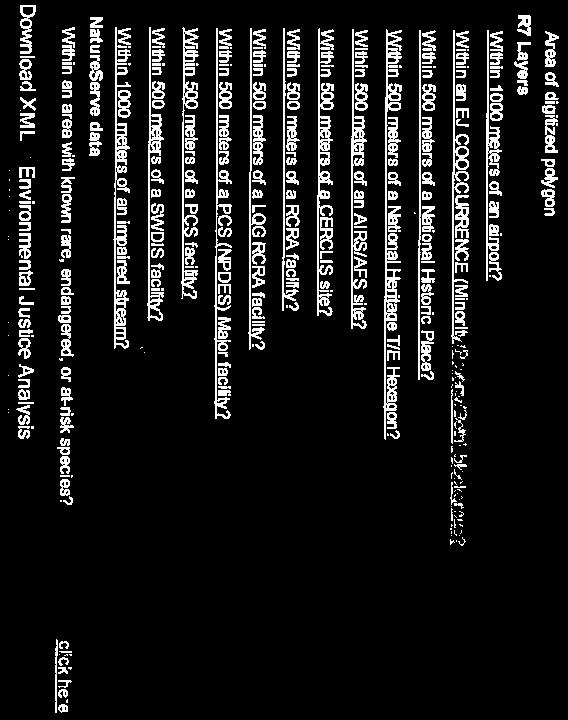


151
152 Missouri Federal Assistance Clearinghouse
153 Jeremiah W. (Jay) Nixon Governor February 15, 2011 State of Missouri OFFICE OF ADMINISTRATION Post Office Box 809 Jefferson City, Missouri Phone: (573) Fax: (573) Kelvin L. Simmons Commissioner David Full RS&H 369 Pine Street Suite 610 San Francisco, CA Dear Mr. Full: Subject Legal Name: RS&H Assistance CFDA: 0 Project Description: EA.: - Agency Coordination - Boone County,MO The Missouri Federal Assistance Clearinghouse, in cooperation with state and local agencies interested or possibly affected, has completed the review on the above project application. None of the agencies involved in the review had comments or recommendations to offer at this time. This concludes the Clearinghouse's review. A copy of this letter is to be attached to the application as evidence of compliance with the State Clearinghouse requirements. Please be advised that I am the contact for the Federal Funding Clearinghouse. You can send future requests to the following address: Sara VanderFeltz, Federal Funding Clearinghouse, 201 West Capitol, Room 125, and Jefferson City, Missouri Sincerely, Sara VanderFeltz Administrative Assistant cc:
154 Missouri Department of Conservation
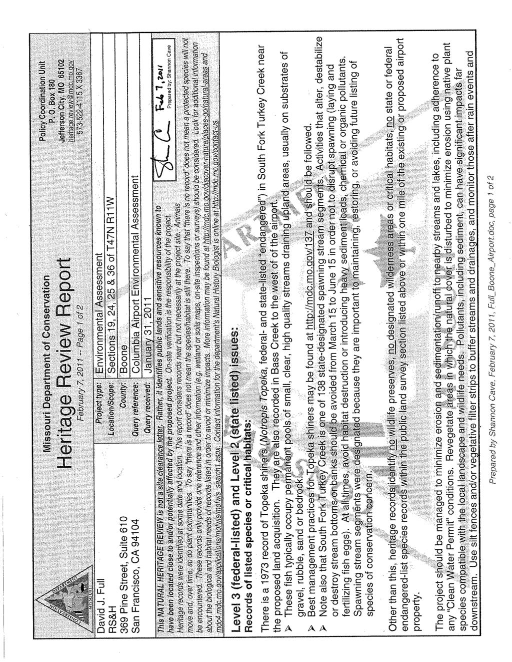
155
156 USDA and Natural Resource Conservation Service
157
158
159 Appendix B-1 Agencies Consulted During the Master Planning Process APPENDIX B-1 Agencies Consulted During the Master Planning Process Reynolds, Smith, and Hills Environmental Assessment B-1-1 January 2012
160
161
162
163
164
165
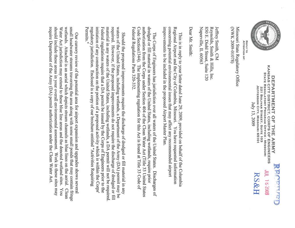
166
167
168
169
170
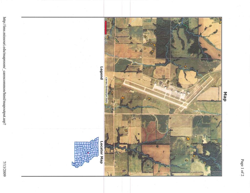
171
172
173
174
175
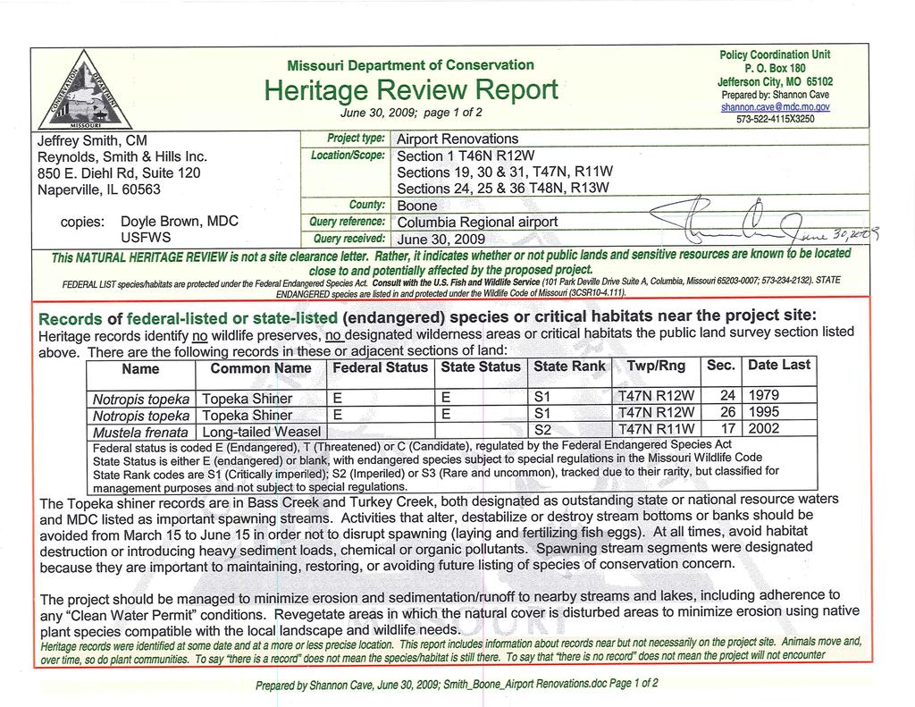
176
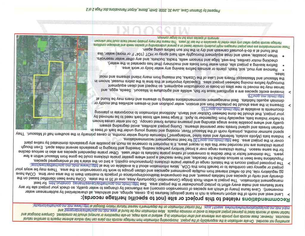
177
178 Master Plan Environmental Agency Coordination Summary Agency - Contacted Contact Person (Title) Agency (Address) Agency Response Received Agency Response Date Response Received From Agency Objection* 1 Missouri Department of Natural Resources Division of State Parks Planning and Development Mr. Chris Buckland Missouri Department of Natural Resources Division of State Parks Planning and Development 1659 E. Elm Street Jefferson City, MO Jul-09 Ms. Jane Lale, Director of Planning and Development None 2 Missouri State Program Manager U.S. Army Corp of Engineers Mr. Ward Lenz Missouri State Program Manager U.S. Army Corp of Engineers 221 Bolivar Street Suite 103 Jefferson City, MO Jul-09 Mr. James Ptacek, Regulatory Project Manager Conditional 3 Missouri Department of Conservation Policy and Coordination Unit Mr. Doyle Brown Missouri Dept of Conservation Department of Policy and Coordination 2901 W. Truman Blvd. Jefferson City, MO Jun-09 Mr. Doyle Brown, MDC Conditional 4 Missouri Department of Transportation MoDOT Transportation Planning Machelle Watkins, Transportation Planning Director MoDOT Missouri Department of Transportation Transportation Planning 2217 St. Mary s Blvd. Jefferson City, MO Jul-09 Mr. Michael Dusenburg, District Planning Manager Conditional T:\P\ Columbia Master Plan\Planning Material\Environmental\COU Environmental Agency Coordination List.xlsx 1 12/7/2009
179 Agency - Contacted Contact Person (Title) Agency (Address) Agency Response Received Agency Response Date Response Received From Agency Objection* 5 Missouri Department of Transportation Aviation Section Jason Knipp, Senior State Planner MoDOT Missouri Department of Transportation Aviation Section 2217 St. Mary s Blvd. Jefferson City, MO Jul-09 Mr. Jason Knipp, Conditional Senior State Planner 6 US Department of Agriculture, Natural Resource Conservation Service State Office Mr. John Baker Mr. Dwaine Gelnar Acting State Conservationist USDA, Natural Conservation Service State Office Parkade Center, Suite Business Loop 70 West Columbia, Missouri Aug-09 Mr. Scott Larsen Area Resource Soil Scientist Conditional 7 Missouri Department of Natural Resources Air Pollution Control Program Mr. James Kavanaugh Missouri Department of Natural Resources Air Pollution Control Program 1659 E. Elm Street Jefferson City, Missouri Jul-09 Mr. Steven Feeler, Compliance/Enforce ment Section Chief None 8 Missouri Department of Natural Resources State Historic Preservation Office Ms. Judy Deel Missouri Department of Natural Resources State Historic Preservation Office 1101 Riverside Drive Jefferson City, MO Jul-09 Mr. Mark Miles Director and Deputy, State Historic Preservation Officer Conditional *Denotes: 'None' - Agency has identified no impacts based on information provided. Coordination should be reassessed due to possible on site natural and/or policy changes. 'Conditional' - Subject to additional agency coordination, assessment, and/or evaluation. T:\P\ Columbia Master Plan\Planning Material\Environmental\COU Environmental Agency Coordination List.xlsx 2 12/7/2009
180 Appendix B-2 Tribal Coordination APPENDIX B-2 Tribal Coordination Reynolds, Smith, and Hills Environmental Assessment B-2-1 January 2012
181 Appendix B-2 Tribal Coordination On September 20, 2011, the FAA distributed Tribal coordination letters to the following Native American tribes: Osage Nation, Iowa Tribe of Oklahoma, Kaw Nation, Miami Tribe of Oklahoma, Omaha Tribe, and Yankton Sioux Tribe of South Dakota. In response to the FAA s Tribal coordination letters, the Osage Nation, Kaw Nation and Yankton Sioux Tribe of South Dakota requested either additional information or provided input for this EA. The Osage Nation requested to review the Cultural Resources Report developed for this EA. On October 26, 2011, the FAA (via ) sent the Osage Nation the Cultural Resource Investigations Phase I Survey (see Appendix F of this EA). The FAA also received letters dated October 28, 2011 from the Kaw Nation and Yankton Sioux Tribe of South Dakota. Each Native American Tribe requested to be contacted in the event that human remains were discovered or located during construction activities. To date, the following Native American tribes have not provided responses to the FAA s September 2011 Tribal coordination letter: Iowa Tribe of Oklahoma, Miami Tribe of Oklahoma, and Omaha Tribe. Reynolds, Smith, and Hills Environmental Assessment B-2-2 January 2012
182 U.S. Department of Transportation Central Region 901 Locust Federal Aviation Iowa, Kansas, Kansas City, Missouri Administration Missouri, Nebraska (816) September 20, 2011 Ms. Janice Rowe-Kurak Chairman Iowa Tribe of Oklahoma Route 1, Box 721 Perkins, OK Re: Environmental Assessment (EA) s Early Coordination ; Columbia, MO Dear Ms. Rowe-Kurak: An EA is being prepared for the City of Columbia for proposed development at the Columbia Regional Airport. The FAA is the lead federal agency for the NEPA document. Jim Johnson, FAA Central Region Airports Division Manager, will be making the final FAA decision on the EA. The FAA is offering the opportunity to provide input on the project. The airport is located 10 miles southeast of Columbia, MO at latitude 38 degrees, 49.1 minutes and longitude 92 degrees and 13.2 minutes. To assist in the analysis, we are enclosing a map showing the proposed development and a list of environmental categories with preliminary analysis. The development includes the following major projects: Extend Runway 31 by 1,849 feet; Remove 1,250 feet from Runway 13; Extend Runway 20 and parallel taxiway by 899 feet; Rehabilitate and reconstruct runways and taxiways; Acquire land for runway safety area improvements; Realign Rangeline Road and Highway H; Preliminary site development for terminal redevelopment; Expand apron and associated taxiway system; and Expand parking lot capacity.
183 To help in our preparation of the EA, we would appreciate your input, including any regulatory, compliance, or permitting requirements within thirty (30) days. If you have questions or require additional information, please contact me at or Sincerely, Glenn Helm, P.E. Environmental Specialist Enclosures
184 U.S. Department of Transportation Central Region 901 Locust Federal Aviation Iowa, Kansas, Kansas City, Missouri Administration Missouri, Nebraska (816) September 20, 2011 Ms. Crystal Douglas Historic Preservation Officer Kaw Nation P.O. Box 50 Kaw City, OK Re: Environmental Assessment (EA) s Early Coordination ; Columbia, MO Dear Ms. Crystal Douglas: An EA is being prepared for the City of Columbia for proposed development at the Columbia Regional Airport. The FAA is the lead federal agency for the NEPA document. Jim Johnson, FAA Central Region Airports Division Manager, will be making the final FAA decision on the EA. The FAA is offering the opportunity to provide input on the project. The airport is located 10 miles southeast of Columbia, MO at latitude 38 degrees, 49.1 minutes and longitude 92 degrees and 13.2 minutes. To assist in the analysis, we are enclosing a map showing the proposed development and a list of environmental categories with preliminary analysis. The development includes the following major projects: Extend Runway 31 by 1,849 feet; Remove 1,250 feet from Runway 13; Extend Runway 20 and parallel taxiway by 899 feet; Rehabilitate and reconstruct runways and taxiways; Acquire land for runway safety area improvements; Realign Rangeline Road and Highway H; Preliminary site development for terminal redevelopment; Expand apron and associated taxiway system; and Expand parking lot capacity.
185 To help in our preparation of the EA, we would appreciate your input, including any regulatory, compliance, or permitting requirements within thirty (30) days. If you have questions or require additional information, please contact me at or Sincerely, Glenn Helm, P.E. Environmental Specialist Enclosures
186 U.S. Department of Transportation Central Region 901 Locust Federal Aviation Iowa, Kansas, Kansas City, Missouri Administration Missouri, Nebraska (816) September 20, 2011 Mr. George Strack Tribal Historic Preservation Officer Miami Tribe of Oklahoma P.O. Box 1326 Miami, OK Re: Environmental Assessment (EA) s Early Coordination ; Columbia, MO Dear Mr. Strack: An EA is being prepared for the City of Columbia for proposed development at the Columbia Regional Airport. The FAA is the lead federal agency for the NEPA document. Jim Johnson, FAA Central Region Airports Division Manager, will be making the final FAA decision on the EA. The FAA is offering the opportunity to provide input on the project. The airport is located 10 miles southeast of Columbia, MO at latitude 38 degrees, 49.1 minutes and longitude 92 degrees and 13.2 minutes. To assist in the analysis, we are enclosing a map showing the proposed development and a list of environmental categories with preliminary analysis. The development includes the following major projects: Extend Runway 31 by 1,849 feet; Remove 1,250 feet from Runway 13; Extend Runway 20 and parallel taxiway by 899 feet; Rehabilitate and reconstruct runways and taxiways; Acquire land for runway safety area improvements; Realign Rangeline Road and Highway H; Preliminary site development for terminal redevelopment; Expand apron and associated taxiway system; and Expand parking lot capacity.
187 To help in our preparation of the EA, we would appreciate your input, including any regulatory, compliance, or permitting requirements within thirty (30) days. If you have questions or require additional information, please contact me at or Sincerely, Glenn Helm, P.E. Environmental Specialist Enclosures
188 U.S. Department of Transportation Central Region 901 Locust Federal Aviation Iowa, Kansas, Kansas City, Missouri Administration Missouri, Nebraska (816) September 20, 2011 Mr. Tony Provost Tribal Historic Preservation Officer Omaha Tribe P.O. Box 368 Macy, NE Re: Environmental Assessment (EA) s Early Coordination ; Columbia, MO Dear Mr. Provost: An EA is being prepared for the City of Columbia for proposed development at the Columbia Regional Airport. The FAA is the lead federal agency for the NEPA document. Jim Johnson, FAA Central Region Airports Division Manager, will be making the final FAA decision on the EA. The FAA is offering the opportunity to provide input on the project. The airport is located 10 miles southeast of Columbia, MO at latitude 38 degrees, 49.1 minutes and longitude 92 degrees and 13.2 minutes. To assist in the analysis, we are enclosing a map showing the proposed development and a list of environmental categories with preliminary analysis. The development includes the following major projects: Extend Runway 31 by 1,849 feet; Remove 1,250 feet from Runway 13; Extend Runway 20 and parallel taxiway by 899 feet; Rehabilitate and reconstruct runways and taxiways; Acquire land for runway safety area improvements; Realign Rangeline Road and Highway H; Preliminary site development for terminal redevelopment; Expand apron and associated taxiway system; and Expand parking lot capacity.
189 To help in our preparation of the EA, we would appreciate your input, including any regulatory, compliance, or permitting requirements within thirty (30) days. If you have questions or require additional information, please contact me at or Sincerely, Glenn Helm, P.E. Environmental Specialist Enclosures
190 U.S. Department of Transportation Central Region 901 Locust Federal Aviation Iowa, Kansas, Kansas City, Missouri Administration Missouri, Nebraska (816) September 20, 2011 Ms. Lana Gravatt Tribal Historic Preservation Officer Yankton Sioux Tribe of South Dakota P.O. Box 248 Marty, SD Re: Environmental Assessment (EA) s Early Coordination ; Columbia, MO Dear Ms. Gravatt: An EA is being prepared for the City of Columbia for proposed development at the Columbia Regional Airport. The FAA is the lead federal agency for the NEPA document. Jim Johnson, FAA Central Region Airports Division Manager, will be making the final FAA decision on the EA. The FAA is offering the opportunity to provide input on the project. The airport is located 10 miles southeast of Columbia, MO at latitude 38 degrees, 49.1 minutes and longitude 92 degrees and 13.2 minutes. To assist in the analysis, we are enclosing a map showing the proposed development and a list of environmental categories with preliminary analysis. The development includes the following major projects: Extend Runway 31 by 1,849 feet; Remove 1,250 feet from Runway 13; Extend Runway 20 and parallel taxiway by 899 feet; Rehabilitate and reconstruct runways and taxiways; Acquire land for runway safety area improvements; Realign Rangeline Road and Highway H; Preliminary site development for terminal redevelopment; Expand apron and associated taxiway system; and Expand parking lot capacity.
191 To help in our preparation of the EA, we would appreciate your input, including any regulatory, compliance, or permitting requirements within thirty (30) days. If you have questions or require additional information, please contact me at or Sincerely, Glenn Helm, P.E. Environmental Specialist Enclosures
192 U.S. Department of Transportation Central Region 901 Locust Federal Aviation Iowa, Kansas, Kansas City, Missouri Administration Missouri, Nebraska (816) September 20, 2011 Dr. Andrea A. Hunter Director, THPO Osage Nation P.O. Box 779 Pawhuska, Oklahoma Re: Environmental Assessment (EA) Early Coordination ; Columbia, MO Dear Dr. Hunter: An EA is being prepared for the City of Columbia for proposed development at the Columbia Regional Airport. The FAA is the lead federal agency for the NEPA document. Jim Johnson, FAA Central Region Airports Division Manager, will be making the final FAA decision on the EA. The FAA is offering the opportunity to provide input on the project. The airport is located 10 miles southeast of Columbia, MO at latitude 38 degrees, 49.1 minutes and longitude 92 degrees and 13.2 minutes. To assist in the analysis, we are enclosing a map showing the proposed development and a list of environmental categories with preliminary analysis. The development includes the following major projects: Extend Runway 31 by 1,849 feet; Remove 1,250 feet from Runway 13; Extend Runway 20 and parallel taxiway by 899 feet; Rehabilitate and reconstruct runways and taxiways; Acquire land for runway safety area improvements; Realign Rangeline Road and Highway H; Preliminary site development for terminal redevelopment; Expand apron and associated taxiway system; and Expand parking lot capacity.
193 To help in our preparation of the EA, we would appreciate your input, including any regulatory, compliance, or permitting requirements within thirty (30) days. If you have questions or require additional information, please contact me at or Sincerely, Glenn Helm, P.E. Environmental Specialist Enclosures
194 m m Runway Safety Area Enhancement, Runway Extensions, and Terminal Area Improvement Environmental Assessment To US63 Highway 'H' Runway End # 13 Removal/Relocation Highway Highway 'H' 'H' Crosswind Crosswind Runway Runway 13/31 13/31 Taxiway Taxiway 'B' 'B' Runway End # 20 Extension Apron Extension Parking Improvements m m Taxiway Taxiway 'A' A4 A5 Primary Primary Runway Runway 2/20 Runway End # 31 Extension Rangeline Road Runway End # 2 Source: Master Plan, RS&H Legend New Pavement Pavement Removal Airport Property Land Acquisition Reconstruction/Rehabilitation ³ Miles Figure 1 Project Components of the Proposed Action
195 Attachment A Environmental Assessment The environmental impact categories that will be evaluated in the EA are described in FAA Order B and include the following: ENVIRONMENTAL OVERVIEW Category Threshold In Airport Environ Air Quality Boone County is listed by the U.S. Environmental Protection Agency (EPA) as being in attainment for all air pollutants. No Coastal Resources Compatible Land Use Construction Impacts Section 4(f) Land Farmlands Fish, Wildlife, and Plants The State of Missouri has no coastal zone management programs in effect. Determination of compatible land use in the vicinity of the Airport will be required based on the identified traffic patterns and noise analysis completed as part of the EA. All construction related to future airport development projects will comply with guidelines set forth in FAA AC 150/ A, Standards for Specifying the Construction of Airports. Section 4(f) lands include historic sites and parks, recreation areas, and wildlife and waterfowl refuges. None of these types of lands are within the boundaries of the Airport. The Mark Twain National Forest is the closest, 1.5 miles east of the Airport. Land acquisition, a component of the Proposed Action would involve the acquisition of 85 acres of land to the northeast of the Airport. The land proposed for acquisition contains 85 acres of prime if drained soils. Form AD-1006 will be completed and sent to the NRCS. Several federally and state listed threatened (T) and endangered (E) species occur in Boone County. The federally listed species include: Gray bat (E), Indiana bat (E), Bald eagle (T), Pallid sturgeon (E), Running buffalo clover (E), and Topeka shiner (E). The state listed species include the: American Bittern (E), Peregrine falcon (E), Northern Harrier (E), Barn owl (E), Interior Least Tern (E), Flathead chub (E), Lake sturgeon (E), and the Plains spotted skunk (E). A habitat assessment will be completed to identify the possible presence of listed species. This data will be used in coordination efforts with the USFWS and the MDNR. No No Yes No Yes Yes
196 Floodplains Federal insurance rate maps indicate there are no 100- year floodplains in close proximity to existing Airport property. The introduction of additional impervious surfaces will be analyzed for potential impacts to floodplains and the drainage at the Airport. Hazardous Materials, Pollution Prevention, and Solid Waste Historical, Architectural, Archeological, and Cultural Resources Light Emissions and Visual Impacts Natural Resources and Energy Supply Noise Secondary (Induced) Socioeconomic, Environmental Justice, and Children s Environmental Health and Safety Risks Water Quality Wetlands Federal, state, and local regulatory agencies databases will be accessed to identify any contamination and hazardous materials in the vicinity of the Airport A Phase I Cultural Resources Survey was conducted in compliance with Section 106 of the National Historic Preservation Act. This report will be coordinated with the SHPO by the FAA. The nearest Registered Historic Property is located approximately 7.5 miles northwest of the Airport. The Proposed Action would involve the addition of airport lighting systems. The use of natural resources and energy will be evaluated in the EA and coordination with local utilities will occur as necessary. The extension of the airfield would alter existing noise contours. The RS&H Team will prepare noise contours showing the DNL contours of 60, 65, 70, and 75 db. Parts of the existing roadway surrounding the airport would be re-aligned as a component of the proposed Action. The proposed airport development will require land acquisition. It is necessary to evaluate the impacts of the land acquisition on the surrounding communities. A number of water bodies surround the Airport (specifically, Bass Creek and Fowler Creek). NWI data shows a few small ponds/depressions (PUBGh) east of Runway 2/20. The USGS quad sheet shows intermittent streams on and adjacent to Airport property. The Corps in their July letter on the Airport Master Plan Update also noted the presence of small headwater streams traversing the area. Wild and Scenic Rivers The Eleven Point River is located approximately 160 miles south of the Airport. No Yes Yes Yes Yes Yes Yes Yes Yes Yes No
197 o u.s. Department of Transportation Central Region 901 Locust Federal Aviation Iowa, Kansas, Kansas City, Missouri Administration Missouri, Nebraska (816) September 20, 2011 Ms. Crystal Douglas Historic Preservation Officer Kaw Nation P.O. Box 50 Kaw City, OK Re: Environmental Assessment (EA)..- Early Coord.ination ; Columbia, MO Dear Ms. Crystal Douglas: An EA is being prepared for the City of Columbia for proposed development at the Columbia Regional Airport. The FAA is the lead federal agency for the NEPA document. Jim Johnson, FAA Central Region Airports Division Manager, will be making the final FAA decision on the EA. The FAA is offering the opportunity to provide input on the project. The airport is located 10 miles southeast of Columbia, MO at latitude 38 degrees, 49.1 minutes and longitude 92 degrees and 13.2 minutes. To assist in the analysis, we are enclosing a map showing the proposed development and a list of environmental categories with preliminary analysis. The development includes the following major projects: Extend Runway 31 by 1,849 feet; Remove 1,250 feet from Runway 13; Extend Runway 20 and parallel taxiway by 899 feet; Rehabilitate and reconstruct runways and taxiways; Acquire land for runway safety area improvements; Realign Rangeline Road and Highway H; Preliminary site development for terminal redevelopment; Expand apron and associated taxiway system; and Expand parking lot capacity. NOV 1 loll
198 To help in our preparation of the EA, we would appreciate your input, including any regulatory, compliance, or permitting requirements within thirty (30) days. If you have questions or require additional information, please contact me at or Sincerely, Glenn Helm, P.E. Environmental Specialist Enclosures
199 FAA Central Region - Development - Boone County I Missouri Glenn Helm to: jmuskres 10/26/ :15 PM ACE-611, Planning Section James. Attached are Phase 1 Cultural Resource Surveys as requested in your October 4, 2011 letter to me. A second survey was done as the Area of Potential Effect was expanded. If you will also want hard copies, please reply via and I will get them to you. Thanks. I cau. Cultural Resource Inv. Phase I Survey Dec 2010.pdt cau Cultural Resource Inv. Phase I Survey' Aug 2011.pdf Glenn Helm, P.E. Environmental Specialist FAA, ACE-611 F Phone: Fax: glenn.helm@faa.gov Website:
200 TRIBAL HISTORIC PRESERVATION OFFICE Date: October 4, 2011 File: MO-I0 RE: FAA Central Region Development in Boone County, Missouri Central Region, FAA Glenn Helm 901 Locust Kansas City, MO Dear Mr. Helm, The Osage Nation Historic Preservation Office has received notification and accompanying information for the proposed project listed as FAA Central Region Development in Boone County, Missouri. The Osage Nation requests a copy of the Phase I cultural resources survey. In accordance with the National Historic Preservation Act, (NHPA) [16 U.S.C w-6] 1966, undertakings subject to the review process are referred to in S10 I (d)(6)(a), which clarifies that historic properties may have religious and cultural significance to Indian tribes. Additionally, Section 106 ofnhpa requires Federal agencies to consider the effects of their actions on historic properties (36 CFR Part 800) as does the National Environmental Policy Act (43 U.S.C and and 40 CFR (a) of 1969). The Osage Nation has a vital interest in protecting its historic and ancestral cultural resources. The Osage Nation anticipates reviewing and commenting on the planned Phase I cultural resources survey for the proposed FAA Central Region Development in Boone County, Missouri. Should you have any questions or need any additional information please feel free to contact me at the number listed below. Thank you for consulting with the Osage Nation on this matter. Archaeologist I OCT Grandview, Pawhuska, OK 74056, (918) , Fax (918)
201 Appendix C People Consulted APPENDIX C People Consulted and Public Involvement Environmental Assessment C-1 January 2012
202 Appendix C People Consulted CONSULTATION AND COORDINATION C.1 PEOPLE CONSULTATED The following persons were contacted for information to support the analysis within this EA: Michael Schupp, Missouri Department of Transportation, Boone County Area Engineer. Darren Campbell, Boone County, Chief Engineer. Scott Larson, Boone County, Area Soil Scientist. C.2 PUBLIC INVOLVEMENT APPROACH AND PROCESS This section contains information related to the public information process. Included is information used to notify federal, state and local agencies as well as the public and other interested parties. In addition, this section includes the locations of the EA document for public review and information associated with the public open house and workshop. Table C-1 ENVIRONMENTAL ASSESSMENT PUBLIC INVOLVEMENT PROCESS Date Outreach Details January 2011 Initial Agency Coordination See Section C.2.1 To be provided Public Open House and Workshop To be provided in Final EA C.2.1 EARLY AGENCY NOTIFICATION AND COORDINATION To initiate agency coordination a agency coordination letter was distributed to various federal, state and local agencies to collect input concerning potential environmental impacts associated with the Proposed Action. The coordination letters requested agency information relating to potential environmental categories described in Appendix A of FAA Order E. The initial agency coordination letter was distributed to the following agencies (see Appendix B, Agency Consulted): State Historic Preservation Office Missouri Department of Natural Resources 100 E. High Street Jefferson City, MO U.S. Army Corps of Engineers Kansas City District 221 Bolivar Street Suite 103 Jefferson City, MO U.S. Fish & Wildlife Service 101 Park DeVille Dr., Suite A Columbia, Missouri USDA, Natural Resource Conservation Service Parkade Center, Suite Business Loop 70 West Columbia, Missouri U.S. Environmental Protection Agency, Region 7 Regional Administrator 901 N. 5 th Street Environmental Assessment C-2 January 2012
203 Appendix C People Consulted Kansas City, KS Missouri Federal Assistance Clearinghouse Missouri State Capitol Building, Room 125 P.O. Box 809 Jefferson City, MO Missouri Department of Conservation Policy Coordination Unit P.O. Box 180 Jefferson City, MO Missouri Department of Natural Resources Jefferson State Office Building P.O. Box 176 Jefferson City, MO Missouri Department of Transportation Central District P.O. Box 718 Jefferson City, MO C.2.2 DRAFT EA NOTIFICATIONS AND DISTRIBUTION The Airport Sponsor has produced and distributed copies of this Draft EA to the agencies identified in Section C.2.1. The City of Columbia has also provided this Draft EA for public viewing at the following locations: 1130 S. Airport Drive Columbia, MO website: Southern Boone County Public Library 117 E. Broadway Ashland, MO Columbia Public Library 100 West Broadway Columbia, MO A Notice of Availability of the Draft EA has been published in the Columbia Daily Tribune announcing the public release of this document, establishing the means to provide comments and the timeframe that the comments will be accepted. C.3 PUBLIC OPEN HOUSE AND WORKSHOP To ensure that the public involvement process is well integrated into the overall decision-making and environmental process, the City of Columbia will coordinate a public meeting on the Draft EA. The City of Columbia will organize and provide presentation materials at a public open house that will be scheduled during the public review period of this Draft EA. Environmental Assessment C-3 January 2012
204 Appendix D Sponsor Land Use Assurance Letter APPENDIX D Sponsor Land Use Assurance Letter Environmental Assessment D-1 January 2012
205 Appendix E Aviation Forecasts APPENDIX E Aviation Forecasts Environmental Assessment E-1 January 2012
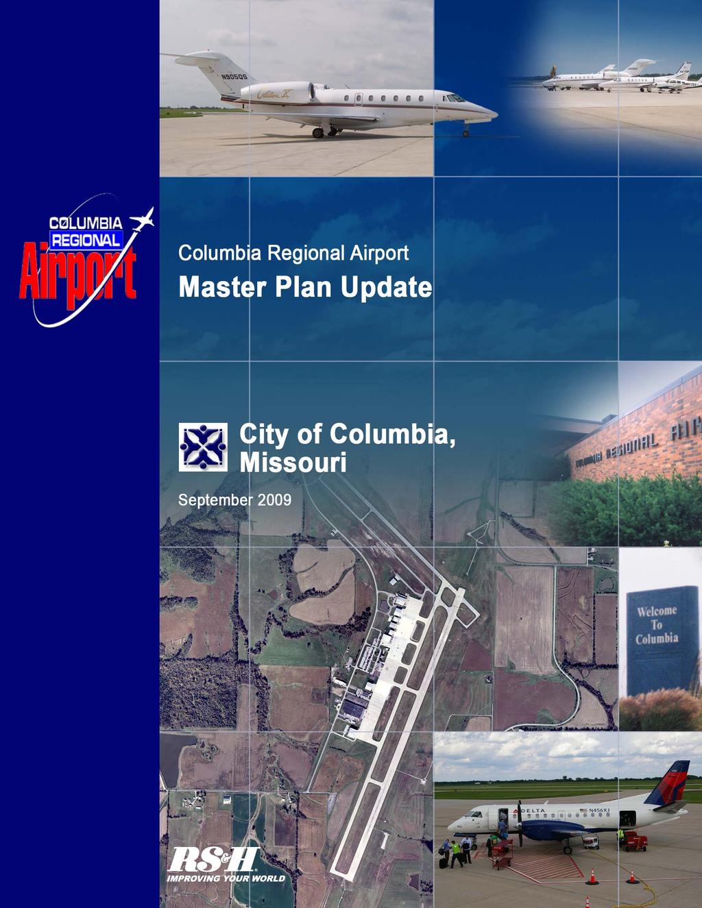
206
207 City of Columbia, Missouri Master Plan Update 2.11 SUMMARY OF FORECASTS Table 2-15 presents a summary listing of the aviation demand forecasts at the Airport. These projections are used in the next chapter of the master plan to assess the capacity of existing facilities and determine facility expansions or improvements needed to satisfy future activity levels. Table 2-15 FORECAST SUMMARY Planning Period Description Average Annual Growth ( ) ENPLANEMENTS Annual 11,521 12,004 12,511 13, % Peak Month 3,042 3,169 3,303 3,591 Average Day Peak Hour ANNUAL OPERATIONS Commercial Service Air Carrier % Commuter 2,891 3,000 3,112 3, % Subtotal 3,076 3,185 3,297 3,532 General Aviation Local 6,799 7,310 7,858 9, % Itinerant 18,669 20,094 21,268 23, % Subtotal 25,468 27,404 29,126 32,378 Military Local % Itinerant % Subtotal 1,211 1,204 1,197 1,184 Total Annual Operations 29,755 31,793 33,620 37, % PEAK OPERATIONS Total Operations 29,755 31,793 33,620 37, % Peak Month 3,243 3,465 3,665 4,043 Average Day Peak Hour BASED AIRCRAFT % Aviation Demand Forecast 2-30 Final
208 Appendix F Historic, Architectural and Archaeological Resources APPENDIX F Historic and Cultural Resources Environmental Assessment F-1 January 2012

209 AUGUST 2011ADDENDUM TO: Cultural Resource Investigations Phase I Survey Project Boone County, Missouri FAA Project Prepared By: Environmental Research Center of Missouri, Inc Moreau Drive Jefferson City, Missouri Phone: craigsturdevant@mchsi.com Principal Investigator: Craig Sturdevant Prepared for: City of Columbia and, Inc. December 2010 ERC Project No. 2808
210 ABSTRACT During December 2010 a Phase I survey was carried out for the proposed expansion project. Approximately 100 acres of land located on the northeast of the existing airport was included in the investigation. Subsequent to the December 2010 survey an additional 90 acres +/- was added to the project. The additional area was the subject of a Phase I cultural resources survey. There are no National Register of Historic Places (NRHP) properties located within the proposed project area; DNR GIS records indicate presence of no recorded archaeology sites within or near the project boundaries; and no Missouri DNR historic architectural sites are present within the project area. The field investigation was carried out under mixed surface visibility conditions in a grass, cultivated, and developed setting. Shovel testing was implemented following guidelines described in this report. Erosion cuts and stream cuts along with shovel testing allowed for a sample of subsurface soil matrix for evaluation of potential for presence/absence of buried cultural resources. The project area is located on an upland divide in a presettlement prairie area. Very few prehistoric archaeology sites have been reported in Missouri in similar settings. The first Phase I survey identified previously unrecorded 23BO2459 which consisted of a scatter of early 20 th century domestic and agricultural materials and is identified as a no longer extant farmstead. The site was determined not eligible for NRHP listing by the SHPO. No cultural resources were identified by the second Phase I cultural resources survey. On the basis of the negative findings regarding presence of possibly significant cultural resources, it is the recommendation of this Phase I cultural resources survey that the proposed airport project proceed as planned in terms of Section 106 compliance concerns. No significant cultural resources will be threatened by the proposed project actions.. 1
211 TABLE OF CONTENTS ABSTRACT 1 TABLE OF CONTENTS 2 LIST OF FIGURES & PHOTOGRAPHS 3 INTRODUCTION 4 Purpose of Study 4 Project Personnel and Schedule 5 The Project 5 INVESTIGATION METHODS 7 Introduction 7 Records and Literature Review 7 Field Procedures 8 Analysis Procedures 9 Statement of Findings and Recommendations 10 PROJECT SETTING 11 Environmental Setting 11 Cultural Setting 12 INVESTIGATION FINDINGS 18 Records and Literature Review 22 Field Investigation Findings 20 General Findings 21 RECOMMENDATIONS 23 BIBLIOGRAPHY 24 2
212 LIST OF FIGURES & PHOTOGRAPHS Figure 1. USGS Quadrangle Location of Project Area Surveyed & Cultural Resources 6 Figure 2. DNR Study Unit Location of Project 13 Figure 3. Aerial Photograph of Area Surveyed 22 Photograph 1. Soybean Field in Project Area 21 3
213 INTRODUCTION Purpose of Study In compliance with current environmental regulations and policies, Reynolds, Smith and Hills, Inc. entered into a contractual agreement with Environmental Research Center of Missouri, Inc. (ERC) to conduct a Phase I cultural resource survey of the proposed improvements project in Boone County, Missouri. The study followed the Missouri Department of Natural Resources (DNR) "Guidelines for Cultural Resource Contract Reports and Professional Qualifications" and is submitted in accordance with current environmental regulations and policies and in agreement with the study contract. The project actions included discussion of the project with Missouri Department of Natural Resources/Historic Preservation Program staff, a records and literature review, and an intensive pedestrian field investigation of the project area. The study methods used are described and the results of the findings of these actions are presented in terms of cultural resource descriptions, when present, and recommendations for cultural resource compliance in reference to the proposed project actions. The project area cultural and environmental settings are briefly described. Under state and federal legislation and policies outlined by the Antiquities Act of 1906, the Historic Sites Act of 1935, the National Historic Preservation Act (NHPA) of 1966 as amended, the National Environmental Policy Act of 1970, the 1986 Protection of Historic Properties and other regulations regarding specific activities such as strip mining, it is necessary to inventory archaeological and historical resources located within proposed project areas which may be threatened by federally regulated or funded actions and evaluate any disruptive effects these actions might have on resources that are present. Briefly, the National Historic Preservation Act requires that an area threatened by a federally funded and/or regulated project consider cultural resources which might be impacted by project related actions; the State Historic Preservation Officer (SHPO) and/or federal agency involved may request that a cultural resource survey be conducted prior to granting permission to proceed with the proposed project actions. If any cultural resources are identified, they are evaluated in terms of National Register of Historic Places (NRHP) eligibility criteria. Where NRHP eligible sites are found to occupy compliance project areas, consultation is initiated which may include the Advisory Council on Historic Preservation (Council), the SHPO, and the governmental agency involved in the project. If an eligible site cannot be avoided, a Memorandum of Agreement may be prepared which would stipulate specific compliance actions to be initiated prior to project actions. The project initiator, if not a federal agency, may be requested to concur. The present project is partially funded or regulated by a federal agency. As a result, cultural resource compliance has been implemented by a federal agency and Missouri SHPO and the present survey has been carried out in order to meet NHPA requirements. 4
214 Project Personnel and Schedule The present project was carried out during December Principal Investigator and report author is Craig Sturdevant. Sturdevant has a Master of Arts degree in Anthropology from the University of Iowa, Iowa City and meets state and federal requirements for Principal Investigator for cultural resource compliance projects. Chris Hansman, Ted Carskadan (ERC Research Associates), and Sturdevant were field technicians for the project. The Project The total proposed project area includes approximately 90 acres of land located on the east side of the existing. A detailed project plan and profile was not included in the scope of work and it was assumed that any cultural resources located within area surveyed would be threatened by project actions. The project is located in Sections 30 and 31, Township 47 North, Range 11 West, Boone County, Missouri (Figure 1). The present investigation has been carried out utilizing Phase I survey procedures as outlined in the methods section of this report and available standard procedures for determining presence/absence of buried resources. Findings and recommendations are made with the understanding that it sometimes may not be possible to identify all possibly significant resources within a project area, particularly where vegetation is extremely heavy or valley settings with deep alluvium. 5
215 6
216 INVESTIGATION METHODS Introduction The major goal of the this investigation was the inventory and evaluation of cultural resources within the designated project zone through the use of currently accepted Phase I survey techniques and records and literature review. It is important that sufficient data are collected to allow development of appropriate recommendations concerning the significance of the identified cultural resources in the project zone in terms of National Register of Historic Places (NRHP) eligibility criteria. The methods and techniques used during the present investigation allowed an intensity of coverage that should have identified all potentially significant cultural resources. Deeply buried sites and very low material density sites are possible to miss no matter how intensive the survey techniques. This study has been initiated in order to carry out federally mandated Section 106 compliance regulations. The scope of work placed emphasis upon identification of cultural resources within the project area along with recovery of sufficient data to allow the Missouri SHPO to make an informed determination of possible significance of those resources. The following section includes a discussion of the methods that have been employed in this study. These consist of a pre-field evaluation of pertinent literature and records from which the field survey techniques and site designation criteria are developed, an intensive pedestrian survey of the project area, an attempt to recover sufficient data for site designation and evaluation in terms of NRHP eligibility requirements, notation of locational information regarding site provenience and physiographic setting, post-field activates involving data analysis, and report preparation. The methods and techniques and justifications for interpretations are discussed below. Records & Literature Review A review of relevant publications and records prior to the field component of the study is important in establishing an understanding of the cultural sequence and types of cultural resources which might be expected to occur. The process begins with review of cultural resource management (CRM) reports that have been produced for the areas near the project zone. These reports are housed in the Missouri Department of Natural Resources State Historic Preservation Office (MoSHPO), Jefferson City, Missouri and are catalogued by county as well as author. The repository also includes historic - architecture site forms for the state, NRHP forms for Missouri, and correspondence regarding the proposed project. Archaeological Survey of Missouri (ASM) records located at the MoSHPO were also reviewed. The ASM files contain information on reported archaeological sites in Missouri that have been gathered for over 70 years which are catalogued by county and section, township, and range and UTM coordinates. The MoSHPO GIS data includes overlays illustrating recorded archaeology sites and areas that have been the subject of previous cultural resource surveys. Other resources 7
217 consulted that contain important data include the state library in Jefferson City, the State Archives in Jefferson City, local historic societies when available, and the State Historic Society in Columbia. Other archaeologists and architectural historians, particularly those employed by the state that are involved with Section 106 procedures, are consulted regarding their knowledge of significant cultural resources in a project area. Field Procedures The archaeological field component of the present study involved pedestrian coverage of the defined project area by ERC personnel. Transect width utilized ranged from 5 to 15 meters depending upon visibility and site potential based on terrain, streams, and other factors that have been shown to correlate with site presence/absence such as presettlement prairie or woodland setting. All vegetation-free zones are observed for presence of prehistoric cultural materials. Throughout most of Missouri, this can include lithic debitage (chert flakes and shatter), fire-cracked rock, pottery sherds and occasionally bone and shell fragments. Features such as fire hearths and burial tumuli may also be encountered. Where vegetation covers the surface for over 10 meters, shovel tests are implemented. This involves removal of around a 50 cm by 50 cm area of sod and then controlled removal of subsurface soil matrix to depths of up to 50 cm below surface. Soils are carefully observed to determine presence/absence of cultural evidence. Where soil conditions allow, soils are screened through a portable 1/4 inch screen. Shovel testing that does not include screening of matrix is implemented where larger numbers of shovel tests are necessary and surface visibility conditions are poor. In this instance, soil matrix is removed by shovel and carefully scraped with a trowel to look for prehistoric/early historic evidence. Where evidence of presence of an archaeological resource is defined, the location is noted on a U.S.G.S. quadrangle and a sketch map and description of the site area are field prepared. Where features or structures are encountered, photographs are taken. The field procedures incorporated in the pedestrian survey are directed toward two major goals: The first was the inventory of all possibly significant cultural resources within the project zone and the second the attempt to recover sufficient information to allow interpretation of NRHP eligibility of these sites by the MoSHPO. While subjective, ERC has developed a set of criteria for determining the presence of an archaeological resource, which are currently accepted by the SHPO as appropriate. These criteria are not presented as appropriate for all situations but as the general practice followed by ERC in making decisions regarding presence/absence of archaeological resources for cultural resource compliance purposes. One extreme would record a site where any evidence of cultural activity occurs. The other extreme would require a significant cultural resource to be present to result in recording a site. The present approach attempts to find a middle ground, which hopefully allows for further consideration for both the cultural resource and the proposed project action prior to threat to either. 8
218 An archaeology site is designated when evidence of prehistoric and/or early historic land use is present and at least one of the following specific criteria is met: A. A prehistoric feature is present B. Two or more artifacts are identified within a 10 by 10m or less area C. A shovel test recovers 2 or more artifacts. Where a site is identified and when the landowner grants permission, materials recovered by the field investigation are placed in field site number marked collection bags. If permission is not attained, materials are observed and potential diagnostics and tools measured, photographed and left in the field or given to the landowner when requested. When a permanent site number is assigned, retained materials are curated with the site designation. Where material density at a site is obviously high only a representative sample is retained. Historic architecture resources include structures and features. Where structures are present that are over 45 years old or exhibit some form of possible exceptional significance they are photographed and a description of architectural features is prepared along with preliminary evaluation of NRHP eligibility when located within a direct impact project zone. Historic structures are not recorded where it is obvious that the structures are less than 45 years old and not significant in any other respect. Where an area of potential effect (APE) has been established beyond the physical APE, architectural resources within this defined APE obviously 45 years or older are photographed and located on report maps. Analysis Procedures Significance of cultural resources is interpreted from National Register of Historic Place eligibility criteria that are listed below: "The quality of significance in American History, architecture, archaeology, and culture is present in districts, sites, buildings, structures, and objects that possess integrity of location, design, setting, materials, workmanship, feeling and association, and: A) that are associated with events that have made a significant contribution to the broad patterns of our history; or B) that are associated with the lives of persons significant in our past; or 9
219 C) that embody the distinctive characteristics of type, period, or method of construction, or that represent the work of a master, or that possess high artistic values, or that represent a significant distinguishing entity whose components may lack individual distinction; or D) that have yielded, or may be likely to yield, information important in prehistory or history: (36 CFR Part 60.6). Cultural resources that are identified during the Phase I survey are evaluated in terms of meeting one or more of the above criteria. In general, archaeological sites most often are evaluated with reference to D above. A statewide planning document was prepared by the DNR/HPP that allows minimal means for evaluation of potential significance of cultural resources (Weichman and Weston 1986). The statewide plan includes information regarding traditions, types of traditions expected, forms of data that may be potentially important, and research questions that can be incorporated in the interpretation of cultural resource significance where available. Generally, a cultural resource will be evaluated on the basis of types of materials recovered (uniqueness, affiliation, type), resource integrity (degree of disturbance), and material/feature density (density and quantity of artifacts and presence and number of potentially extant features such as hearths, house sites, and burial tumuli). Usually, if an archaeological site exhibits sub-plow zone integrity and produces diagnostic artifacts or features, the site is interpreted as significant in that it would very likely contain sufficient data to contribute to the understanding of the cultural history of the area and meet NRHP eligibility criterion D. The consultant makes recommendations regarding NRHP eligibility. The determination of eligibility process requires consultation with the SHPO and the federal agency involved in the project. Statement of Findings and Recommendations Where ERC locates a cultural resource within the designated project boundaries, recommendations of significance and justification are made to the MoSHPO and the federal agency involved. A decision regarding significance would be made at that level in terms of possible NRHP eligibility of the resource. Recommendations that may be made include not eligible for NRHP status, possibly eligible for NRHP status, or eligible for NRHP status. Where a recommendation of not eligible is accepted by the SHPO and federal agency a proposed compliance project can proceed as planned; a recommendation of possibly eligible results in agency request that the project be modified to avoid the resource or given further evaluation in order to establish NRHP eligibility; a recommendation of eligible results in a request to modify the project to avoid the cultural resource or proceed with the consultation process as outlined by 36 CFR Part 800: Protection of Historic Properties that governs the Section 106 review process established by the National Historic Preservation Act of 1966 as amended. 10
220 PROJECT SETTING Environmental Setting The project area lies on the border of the Dissected Till Plains to the north and Ozark Plateau on the south in Central Lowlands Province of North America. The bedrock in the area consists of Mississippian limestones covered with varying depths of clays and glacial drift as well as limestone residuum and colluvium and alluvium (cf. Branson 1944; Stout and Hoffman 1973). The project is located within a presettlement prairie zone (Kucera 1961; Schroeder 19891:7) in an upland divide between Cedar Creek on the east and Bonne Femme headwaters on the west. The area exhibited a wide variety of indigenous floral species in the past (Chapman 1975:12-16). Early surveyors list several species of oak, hickory, black walnut, hackberry, sycamore, elm, and elders in the bottoms along with open oak-hickory upland woodlands to the east, west, and south and grasses that would have included Big and Little Bluestem, Indian Grass, Switch Grass, Side-oats Grama, and pockets of Bluejoint and Canada Wild Rye in the project area (Allgood and Persinger 1979:60). Some species of animals present during the pioneer period have been extirpated from their former ranges since the Euro-American settlement of the area. These species include gray wolf, elk, and bison (Chapman 1975). The mountain lion and black bear occur rarely in the forested regions of the interior Ozark Highlands (Wood and McMillan 1976). More common species in the drainage basin include white-tailed deer, gray fox, red fox, coyote, raccoon, beaver, bobcat, mink, opossum, muskrat, spotted skunk, squirrels, rabbit, and woodchuck. It is probable that the project area exhibited typical prairie/woodland ecotonal populations in which a variety of large and small game was available in both woodland and prairie settings. The climate within the project area is midcontinental and experiences temperature extremes both seasonally and on a day-to-day basis. This area of Missouri is in the path of cold air moving down out of Canada, warm moist air coming up from the Gulf of Mexico, and dry air from the west. The mean annual precipitation in the area is around 40 inches which includes 12 to 17 inches of snow per year. The mean length of the growing season is around 187 days. The killing freezes generally begin between October 15 and 20 and end between April 15 and 20 (Chapman 1975). The project area exhibits few characteristics suggesting high potential for presence of intensive or extensive prehistoric occupation. The counties north of the Missouri river exhibit an ecotonal situation that included a relatively high percentage of presettlement prairie and lesser amount of presettlement woodland (Schroeder 1981). While Boone County was made up only of 16% presettlement prairie, the present project occupies the only expansive prairie zone in the county. Earlier studies have well 11
221 illustrated the finding that known prehistoric occupations in the region are almost entirely located within presettlement woodland zones with less than 3% of the known prehistoric sites found within presettlement prairie zones (cf. Sturdevant 1983). Another major consideration that appears to have entered into prehistoric site selection involved availability of cherts that were a primary raw material for much of the subsistence technology. Bedrock in the general area does include Missisippian age cherts that were utilized extensively by prehistoric occupants as raw material for tools. These cherts would not have been easily accessible in the project area. The project setting would have also lacked immediate availability of a consistent water supply necessary to support any intensive or extensive human habitation resulting in a low prehistoric site potential. Cultural Setting The project is located in the Central Missouri Drainage Basin (Figure 2). The occupation of Missouri by prehistoric populations has been generally established to include nine to ten traditions (cf. Chapman 1975; 1980). These traditions apply in varying degree to the entire state with some traditions often not accounted for in specific drainages. These traditions are incorporated in what is called the cultural sequence which is a major factor utilized in interpretation of cultural data, particularly regarding National Register of Historic Place (NRHP) significance. These traditions are listed below in the sequence provided by Chapman (1975; 1980). Paleo-Indian to 8000 B.C. Dalton 8000 to 7000 B.C. Early Archaic 7000 to 5000 B.C. Middle Archaic 5000 to 3000 B.C. Late Archaic 3000 to 1000 B.C. Early Woodland 1000 to 500 B.C. Middle Woodland 500 B.C. to A.D. 400 Late Woodland A.D. 400 to 900 Mississippian A.D. 900 to 1400 Paleo-Indian: With the exception of a possible earlier "Early Man" tradition, the Paleo-Indian is generally accepted as the earliest known occupation of Missouri. These specialized hunters lived in small nomadic bands or family groups and left some traces of their transitory settlement pattern in the forms of hunting camps, kill sites, quarry sites, and possibly small base camps (cf. Ford 1974:388). The major diagnostic materials associated with the occupation includes the Clovis and Folsom fluted spear/knife points. Most fluted point finds have been located along major river valleys such as the Missouri River although some have been recovered along streams such as the Moreau River. This has been suggested to indicate that these nomadic hunters and gatherers followed these streams in their movement through the Midwest area. Chapman indicates that his division of the Northeast and Northwest Prairie region at a point in Cooper and Howard counties above Boonville on the Missouri River separates the major occupation zones of the 12
222 Figure 2. DNR Study Unit/Drainage Basin Location of Project Paleo-Indian populations. That is, the steep bluffs below this point appear to have been more conducive to Paleo-Indian occupation than the more prairie related terrain above this point. Fluted points are generally more plentiful below this point toward St. Louis than above this point toward Kansas City (Chapman 1975:75). Chapman's review of Paleo-Indian diagnostics illustrates larger numbers of reported fluted points beginning in Howard County and continuing toward St. Louis with a small number reported from Callaway County (1975:67). Dalton: Chapman characterizes the Dalton period as a time of transition from Paleo-Indian big game hunting to the hunting-foraging subsistence strategy of the following Archaic period (1975:96). All known Dalton sites in Missouri are small camps 13
223 and all apparently represent short-term utilization. The basic Paleo-Indian tool kit was still in use during Dalton times although tools associated with plant food processing were added. Point types with long flutes have been replaced by types with basal thinning and or short flutes. The major diagnostic includes the Dalton Serrated and perhaps the Dalton adze. Distribution roughly parallels the Paleo-Indian. Early Archaic: By the Early Archaic the transition to a subsistence pattern based on foraging was well underway. Subsistence activities were broadened to exploit more ecological niches. Hunting and gathering continued as the major economic activities but emphasis was placed on aquatic resources and vegetal foods. Although nomadic wandering was being replaced by "a regular hunting-gathering range with specific base camp sites that were returned to at regular intervals" (Chapman 1975:135), the typical Early Archaic site continued to be a small hunting and or collecting camp. These are found in a variety of environmental settings throughout Missouri including upland ridges near small ephemeral streams, upland bluff edges, rock shelters, and the margins of high bottomland terraces. Diagnostics of Early Archaic include Graham Cave Notched that has been recovered in the general area (Chapman 1975). Hardin Barbed is also generally associated with Early Archaic occupation. Middle Archaic: The Middle Archaic was basically a continuation and expansion of a forager tradition begun in the Dalton and Early Archaic. A drying climate forced greater reliance upon collecting vegetal foods and small animals as opposed to wet environment subsistence. Sites continued to be small, exhibiting semi-nomadic or seasonal occupation with no specific topographic location associated (Chapman 1975:159). The tool kit continued to expand, depending upon the extraction activity in the specific niche. The drying climate was reflected in the marked tendency for Middle Archaic sites to be located almost exclusively in or very near bottomland settings (Chapman 1975). There are no complexes associated with the period in this general area. Collectors in the area often have Big Sandy forms in their collections. It is assumed that Middle Archaic was present but in an as yet poorly defined situation. Site forms for the drainage are inconclusive in terms of presence of Middle Archaic diagnostics. Late Archaic: The Late Archaic is somewhat better known than earlier traditions. This is a result of the greater population apparently represented by the Late Archaic which resulted in more expansive and numerous occupations. This period generally lacks the small dart point of the earlier traditions that suggests that hunting had become less important for subsistence. In addition, tool kit function appears to have expanded suggesting reliance on a much larger variety of potential foods requiring varied extraction and processing techniques. The Late Archaic began toward the climax of a warming trend that reached its height around 2000 B.C. (Cleland 1966), with a resultant diminishing of the faunal and floral forest species. The Late Archaic peoples had to adapt to new ecological niches with concomitant changes in subsistence related artifacts. Emphasis was probably placed on a method of procurement that could effectively exploit various types of resources which were available in reliable quantities at varying seasons. Using a central-based wandering settlement pattern in which the particular seasonal 14
224 resources available would determine the type and location of temporary camps radiating from more permanent occupation sites, Late Archaic settlement pattern appears to have been somewhat more restricted than previous foraging traditions. Diagnostic artifacts of this period include the Sedalia Lanceolate and Diggers, Clear Fork Gouge, Smith Basal Notch, Afton, Etley, Nebo Hill, Stone Square, as well as 3/4 groove granite axes. Evidence of the Sedalia complex are often found just over the crown of the slope of high ridges (Chapman 1975:200). Late Archaic occupations are one of the more commonly identified traditions in the drainage according to ASM records. Early Woodland: The Early Woodland period is identified by presence of Black Sand Incised pottery and is poorly represented throughout most of Missouri. In spite of intensive surveys in various areas of the state, only a few unquestionable Early Woodland sites have been identified and include Avondale, Renner, and Shields sites in the Kansas City area and a few in the northeast portion of the state. These and other possible Early Woodland sites are generally found in the major river valleys, particularly along the Missouri River. Middle Woodland: The Middle Woodland period occupation in northern Missouri is focused on three related regional centers: The Havana center in the Lower Illinois River Valley and adjacent Mississippi River valley in the northeast, the Kansas City Hopewell, and Big Bend centers. The latter two are on the Missouri River. Analyses of pottery from the three centers indicate there was an intrusion of people into the Big Bend and Kansas City areas from the Havana center to the east (Wedel 1943) although the initial intrusion appears to have been related to subsistence and/or political stress (Struever & Houart 1972) in the Havana center, contacts among the three centers was maintained throughout the Middle Woodland period (Chapman 1980). These continued contacts insured the Big Bend and Kansas City areas of a place in the Classic Middle Woodland's Hopewell Interaction Sphere. Evidence for a Middle Woodland occupation is very sparse outside of the areas noted. Some rock shelters and open habitation sites in the general area have produced Middle Woodland diagnostics and Chapman identified south Boone County as a major Middle Woodland center (1980). There has been no corroborating evidence through field investigations regarding the assertion by Chapman. In general, with the exception of the Big Bend and Kansas City Hopewell, Middle Woodland diagnostics usually are interpreted from lithics such as Snyders points with ceramics reflecting Hopewellian occupation lacking but for the centers. Late Woodland: The Late Woodland period exhibits the most numerous defined components within prehistoric sites in the general project area. The occupation in this portion of Missouri has sometimes been defined as a regression from the preceding traditions in that emphasis on horticulture developed earlier in the Woodland was supplanted by earlier hunting subsistence reliance. This pattern is seen in the increase in small temporary camps along with use of bow and arrow. Diagnostics include grit and limestone tempered pottery, arrow points, burial mounds, and shallow side notched points. Several Late Woodland sites have been identified in the county including both 15
225 open habitation sites and burial tumuli. A large number the archaeological sites identified in the general project area have exhibited Late Woodland diagnostics (Sturdevant 1978). Mississippian: The Early Mississippian period is not well documented in the general area of the project. Steed-Kisker, an Early Mississippi phase, is located in the Kansas City area while Cahokia and the St. Louis area represent a climax associated with Early Mississippian (Chapman 1980). Diagnostics for this period include small triangular arrow points and shell tempered ceramics. Where Early Mississippian experienced climax levels, temples and towns were part of the settlement pattern. In the immediate area only triangular points and an occasional shell tempered sherd have been reported. Early Mississippian Steed-Kisker people apparently abandoned the Kansas City area around A.D and around A.D the Oneota cultural tradition appeared suddenly in the Big Bend area near the junction of the Grand, Chariton, and Missouri rivers. It is speculated that Oneota developed in northern Missouri and Iowa and its formation was stimulated by developments at the Cahokia center. While the extent of Cahokia influences remains unknown, cultural developments of the period in that area have been connected to the cultural background and growth of the historic Siouanspeaking people (Griffin 1960). The most prominent Oneota village in the Big Bend area is the Utz site and it was there the Utz phase, which documents the Oneota culture of the area, was defined. The Utz phase, and the Oneota occupation, began at about A.D and lasted to the end of the Mississippian period (A.D. 1700) when Oneota blends into what is recognized as the Historic Missouri Indian tribe. Historic Period: During the period from 1730 to 1790, the Missouri tribe was being depleted by smallpox and its power was continually being tested by its enemies to the north. By the 1780's, the Missouri became heavily dependent on their allies the Osage for protection. In spite of this, the Sac and Fox conquered and dispersed the Missouri tribe in the 1790's. Those who were not killed joined the Osage, Kansas, and Oto tribes. The great smallpox epidemic of 1823 reduced their numbers to less than one hundred and Missouri as a distinct cultural entity became extinct. The last full-blood Missouri Indian died on the Oto reservation in 1907 (Chapman 1946:29). The lands encompassed by the project were but a small part of North American territory claimed by France until 1762 when it was transferred to Spain by secret treaty. Spain retroceded the land to France in 1801 and France ended up selling it to the U.S. in 1803 as the Louisiana Purchase. In 1812, congress created the Territory of Missouri and in 1821 Missouri was recognized as the twenty-first state (March 1963). In general, the post-1800 history of central Missouri reflects both the general patterns of agricultural developments in the Midwest and specific influences which shaped the region. The process of early settlement and the struggle to produce beyond a meager subsistence, the expansion of the agricultural and commercial activities and creation of a stable society, followed by an era in which regional concerns were shaped by state and national trends, are all recognized as part of the evolution of the Midwest. In the case of northern Missouri, an understanding of its Euro-American past requires recognition of the 16
226 influence of the settlers themselves and of the land which they occupied. The early settlers came primarily from the Upper South, especially Kentucky, Tennessee, and Virginia. Prior to the Civil War, first tobacco and then corn played an important role in the agricultural economy of the region. The first permanent settlers began entering the area in the early 1800's, a process that really began only after the acquisition of the Louisiana territory by the U.S. in Congress created the territory of Missouri in 1812 and nine years later recognized Missouri as the twenty-first state (Meyer 1963). The rapid development from uncharted wilderness to statehood stemmed directly from the massive westward movement of population during the early nineteenth century. Most of the settlers who came to mid-missouri were attracted to the land. The fertile soil, adequate rainfall, and a growing season that averaged six months a year made the region particularly well-suited for agriculture. A rich, friable loam predominated, with substantial stands of timber which provided building materials and generally reminded the immigrants of the lands which they had left behind. The background of the settlers made them receptive to cultivating a crop that would reproduce the agricultural patterns of their native states. Most of the early settlers came from the Upper South that included slave holding states. March (1967) suggests that within the slave belt through central Missouri, major crops included hemp and tobacco. These crops, particularly tobacco, demand intensive labor for productivity. Tobacco is generally favored as a cash crop in that it produced a greater value in proportion to bulk when compared to grain crops. In areas such as the project, transportation would have been a problem prior to the railways. Cash crops such as tobacco in areas that did not provide viable river transportation soon shifted to local consumption crops such as corn and wheat. While not well documented at present, it is apparent that agricultural pursuits were almost entirely geared toward corn and wheat by the time of the Civil War. It is further apparent that slave holding had begun to drop at a relatively high rate prior to the Civil War (Campbell 1874). The land and its location, then, became major shaping forces of the economic system of the area, altering the previous patterns established in the southeast and brought to the Midwest. The coming of the railroad in the 1850 s through the 1870 s opened the interior to greater trade and agricultural products have been the major source of livelihood in the general area since this time. 17
227 Records and Literature Review INVESTIGATION FINDINGS Boone County, Missouri currently contains 49 National Register of Historic Places (NRHP) properties. These include the following: BALLENGER BUILDING, South Ninth Street, Columbia BOND S CHAPEL METHODIST EPISCOPAL CHURCH, Hartsburg JOHN W. ( BLIND ) BOONE HOUSE, 4th Street between East Broadway and Walnut CENTRAL DAIRY BUILDING, East Broadway, Columbia ALBERT BISHOP CHANCE HOUSE AND GARDENS, Centralia CHATOL (CHANCE GUEST HOUSE), Centralia COCA-COLA BOTTLING CO. BUILDING, 10 Hitt Street, Columbia COLUMBIA CEMETERY, 30 East Broadway, Columbia COLUMBIA NATIONAL GUARD ARMORY, 701 East Ash St. Columbia FRED DOUGLAS SCHOOL, 310 North Road SANFORD F. CONLEY HOUSE, 602 Sanford Place, Columbia EAST CAMPUS NEIGHBORHOOD HISTORIC DISTRICT, Columbia DOWNTOWN COLUMBIA HISTORIC DISTRICT (2 parts) SAMUEL H. ELKINS AND ISABEL SMITH HOUSE, 315 North 10th Street, Columbia EIGHTH BROADWAY HISTORIC DISTRICT, Columbia FIRST CHRISTIAN CHURCH, Columbia FRANCIS QUADRANGLE HISTORIC DISTRICT, Columbia GORDON TRACT ARCHAEOLOGICAL SITE, Columbia 18
228 DAVID GORDON HOUSE & COLLINS LOG CABIN, 2100 East Broadway Columbia GREENWOOD, Columbia DAVID GUITAR HOUSE, Columbia SAMUEL E. HACKMAN BULDING, Hartsburg HAMILTON-BROWN SHOE FACTORY, 1123 Wilkes Blvd., Columbia WILLIAM B. HUNT HOUSE, 8939 West Terrapin Hills Road, Columbia KRESS BUILDING, 1025 East Broadway, Columbia MAPLEWOOD, Nifong & Ponderosa, Columbia McCAIN FURNITURE STORE, 916 East Walnut, Columbia KANSAS AND TEXAS RAILROAD DEPOT, Columbia MISSOURI STATE TEACHERS ASSOCIATION, Columbia MISSOURI THEATER, South 9th Street, Columbia MISSOURI UNITED METHODIST CHURCH, Columbia NORTH NINTH STREET HISTORIC DISTRICT, Columbia MOSES PAYNE HOUSE, Rocheport vicinity PIERCE PENNANT MOTOR HOTEL, Columbia ROCHEPORT HISTORIC DISTRICT, Rocheport ST. PAUL S A.M.E. CHURCH, 501 Park Street, Columbia SANBORN FIELD AND SOIL EROSION PLOTS, UMC, Columbia SECOND BAPTIST CHURCH, 407 East Broadway SECOND CHRISTIAN CHURCH, 401 North 5th Street, Columbia SENIOR HALL, Stephens Campus, Columbia 19
229 STEPHENS COLLEGE, SOUTH CAMPUS, 1200 East Broadway, Columbia JOHN AND ELIZABETH TAYLOR HOUSE, 716 West Broadway, Columbia TIGER HOTEL, Columbia VIRGINIA BUILDING, 111 South Ninth Street, Columbia WABASH RAILROAD STATION AND FREIGHT HOUSE, 126 North 10th Street, Columbia. WEST BROADWAY HISTORIC DISTRICT, West Broadway, Columbia WRIGHT BROTHERS MULE BARN, Hinkson Avenue, Columbia. No NRHP property is located within the project boundaries. No NRHP property will be directly or indirectly threatened by the proposed project actions. There are no previously recorded prehistoric archaeology sites within the same sections of land as the project although there are several located to the east along Cedar Creek and to the west in the Bonne Femme Creek valley (DNR GIS Archaeology Layer Boone County). The project area contains no recorded historic architecture or possibly significant historic events. Review of 19 th and 20 th century plat maps and 20 th century USGS topographic quadrangles found no evidence of structures within the proposed project area on the 1898 or 1917 plat maps. The 1967/1981 USGS topographic quadrangle illustrates no structures in the project area. The existing airport construction began in 1967 and contains no structures that would meet the general NRHP 50-year requirement. Field Investigation Findings The field investigation was carried out under a variety of surface visibility conditions ranging from 0 to 100% in a rural setting including a soybean and corn fields and grasses in a fallow field setting (Photograph 1; Figure 3). Shovel tests were utilized in order to interpret presence/absence of cultural resources as described in the methods section of this report. The presence of small stream banks, erosion cuts, and road cuts along with shovel tests allowed for a sample of subsurface soil matrix for interpretation of potential for presence/absence of buried cultural resources. The field investigation failed to identify the presence of any evidence of prehistoric occupation. The project area historic resources include a constructed pond, fences, no longer used Ridge Line Road, and utilities. None of these historic features 20

230 Photograph 1. Soybean Field in Project Area (view to southeast) meet the investigators historic site designation criteria as outlined in the methods section of this report.. General Findings The present Phase I investigation included approximately 90 acres of land on the east side of the existing. The area occupies an upland divide between Cedar Creek to the east and Bonne Femme headwaters to the west. The area exhibited no evidence of prehistoric occupation although it is probable that early populations utilized the area on a short term basis for extraction of subsistence species. The presettlement setting was prairie. As previously discussed, these areas in Missouri exhibit less than 3% of the recorded prehistoric sites in the northern half of the state where presettlement prairie ranged from around 15 to 80% of the total vegetation. The present findings support earlier hypotheses regarding presettlement vegetation and prehistoric land use (Sturdevant 1983). It is the finding of this Phase I cultural resources survey that the proposed project area does not contain significant cultural resources. It is also highly unlikely that buried significant cultural resources would be present given the setting and small sample of subsurface soil matrix available for profiling and observation along stream and road cuts. 21
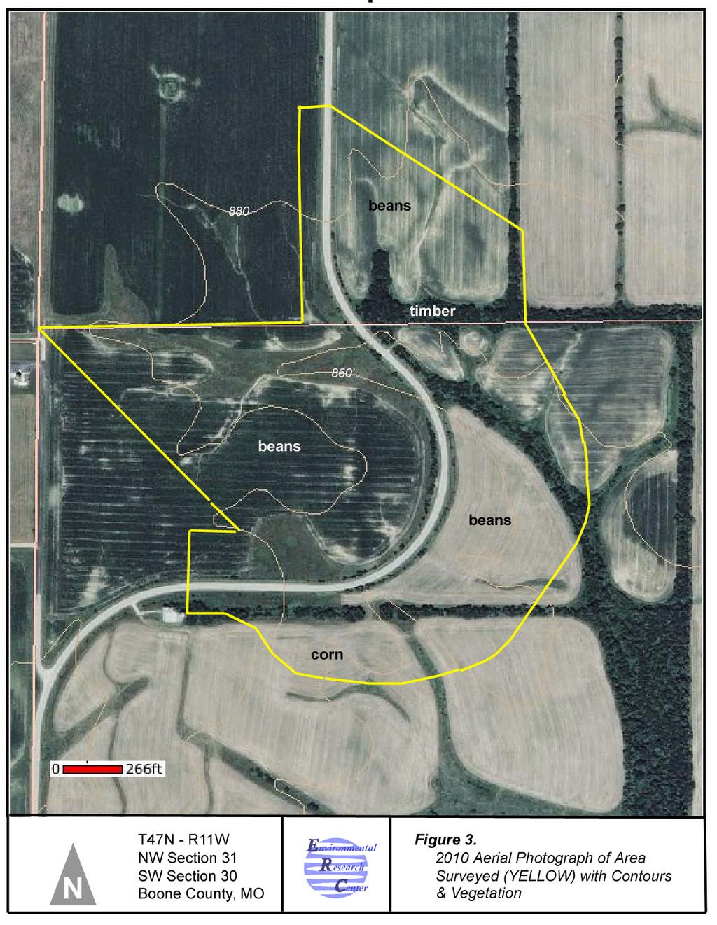
231 22
232 RECOMMENDATIONS During December 2010 a Phase I survey was carried out for the proposed expansion project. Approximately 100 acres of land located on the northeast of the existing airport was included in the investigation. Subsequent to the December 2010 survey an additional 90 acres +/- was added to the project. The additional area was the subject of a Phase I cultural resources survey. There are no National Register of Historic Places (NRHP) properties located within the proposed project area; DNR GIS records indicate presence of no recorded archaeology sites within or near the project boundaries; and no Missouri DNR historic architectural sites are present within the project area. The field investigation was carried out under mixed surface visibility conditions in a grass, cultivated, and developed setting. Shovel testing was implemented following guidelines described in this report. Erosion cuts and stream cuts along with shovel testing allowed for a sample of subsurface soil matrix for evaluation of potential for presence/absence of buried cultural resources. The project area is located on an upland divide in a presettlement prairie area. Very few prehistoric archaeology sites have been reported in Missouri in similar settings. The first Phase I survey identified previously unrecorded 23BO2459 which consisted of a scatter of early 20 th century domestic and agricultural materials and is identified as a no longer extant farmstead. The site was determined not eligible for NRHP listing by the SHPO. No cultural resources were identified by the second Phase I cultural resources survey. On the basis of the negative findings regarding presence of possibly significant cultural resources, it is the recommendation of this Phase I cultural resources survey that the proposed airport project proceed as planned in terms of Section 106 compliance concerns. No significant cultural resources will be threatened by the proposed project actions. 23
233 BIBLIOGRAPHY Allgood, F. P. and I. D. Persinger 1979 Missouri General Soil Map and Soil Association Descriptions. Soil Conservation Service. Columbia. Asch, D. I The Middle Woodland Population of the Lower Illinois River Valley: A Study in Paleodemographic Methods. Northwestern University Archaeological Program, Scientific Papers, 1. Baker, M Analysis of Refuse Pits 23CO156, Cole County, Missouri. M.A. Thesis. UMC. Anthropology Department. Boone County Land Assessment Book 1875 through State Archives. Branson, E. B The Geology of Missouri. University of Missouri Studies. Vol. 19, No. 3. Columbia. Broadhead, G. C Prehistoric Evidences in Missouri. Annual Report of the Smithsonian Institution for the Year Washington D.C. Campbell, R. A Gazetteer of Missouri. R.A. Campbell. St. Louis. Chapman, C. H The Archaeology of Missouri I. University of Missouri Press. Columbia The Archaeology of Missouri II. University of Missouri Press. Cleland, C. E The Focal-Diffuse Model: An Evolutional Perspective on the Prehistoric Cultural Adaptations of the Eastern U. S. Midcontinental Journal of Archaeology. 1:
234 Collier, J. E Geographic Regions of Missouri. Annals of the Association of American Geographers. 45 (4): Conard, H. L Encyclopedia of the History of Missouri. The Southern History Company. New York. Denny, S. G A Re-evaluation of the Boone Focus: A Late Woodland Manifestation in Central Missouri. M.A. Thesis, UMC. Edwards Brothers 1875 Historical Atlas of Boone County, Missouri. Edwards Brothers Philadelphia. Evans, D. R., E. G. Garrison, and D. J. Ives 1977 Cultural Resources Survey: Columbia, Missouri, Phase I Sewer Improvements. EPA. Fowkes, G Antiquities of Central and Southeastern Missouri. Smithsonian Institute, Bureau of American Ethnology Bulletin 37. Washington D.C. Grantham, L Cultural Resources Survey Long Branch Lake: Archaeology Resources. COE. Griffin, J. B Some Correlations of Climate and Cultural Change in Eastern North American Prehistory. Annals, New York Academy of Science. 95: Haas, D An Archaeological Survey of the Little Femme Osage River Hills Area and the Loutre River Valley. DNR. Howe, W. B. and J. W. Koenig 1963 The Stratigraphic Succession in Missouri. Geological Survey and Water Resources Series 3. Klippel, W. E An Archaeological Investigation of the Lower Osage River Valley in Missouri. M.A. Thesis, UMC. 25
235 Kay, M The Central Missouri Hopewell Subsistence - Settlement System. Missouri Archaeological Society, Research Series No. 15. March, D. D The History of Missouri. Lewis Historical Company. New York. Martin, T An Archaeological Survey in the Middle Drainage - Lamine River. DNR/HPP Grant. Jefferson City. Northup, B. B We are Not Yet Conquered: The History of the Northern Cherokee Nation of the Old Louisiana Territory. Turner Publ. Co. Paducah, Kentucky. Northwest Publishing Co Plat Map of Boone County, Missouri. Northwest Publishing Co. Philadelphia. O Brien, M Archaeological Testing of the Route 63, Boone County Project, Missouri. MoDOT. Ogle, G. A Standard Atlas of Boone County, Missouri. George A. Ogle & Co. Chicago. Raisz, I Physiographic Regions of the U.S. Map. Reeder, R. L., E. E. Voigt, and M. J. O'Brien 1983 Investigations in the Lower Perche - Hinkson Drainage. EPA. Rollins, J. S Land Entry Atlas of Boone County, Missouri State Archives. Schmits, L. J Archaeological Investigations at the Roddy Site (23BO966) and the Coates Sites (23BO965), Boone County, Missouri. EPA. 26
236 Schmits, L. et al Prehistory of the Lower Perche- Hinkson Drainage Central Missouri Archaeological Investigations at the Columbia Regional Wastewater treatment Facility. Shoemaker, F. C Missouri and Missourians. Lewis Publishing Company, Chicago. Stevens, W. B Missouri the Center State, Vol. II. S. J. Clarke Publishing, St. Louis. Struever, S. and G. I. Houart 1972 An Analysis of Hopewell Interaction Sphere: IN Social Exchange and Interaction. E. N. Wilmsen editor. University of Michigan, Museum of Anthropology, Anthropological Papers. No. 3. Sturdevant, C Cultural Resource Survey, Algoa Reformatory, Cole County, Missouri. DNR/HPP Phase III Data Recovery, 23CY499, Callaway County, Missouri. MoDOT Cultural Resource Investigations, Phase I Survey, Columbia Regional Airport Project, Boone County, Missouri. FAA. Wedel, M. M Archaeological Investigations in Platte and Clay Counties, Missouri. U. S. National Museum Bulletin, No Weichman, M. S. and D. Weston 1986 Master Plan for Archaeological Resource Protection in Missouri. DNR/HPP. Jefferson City. 27
237 Appendix G Biotic Resources APPENDIX G Biotic Resources Environmental Assessment G-1 January 2012
238 A Survey of Sensitive Species and Evaluation of Habitat Quality Relative to the Expansion of the, Missouri Submitted to: Nick Kozlik, RS&H Deer wood Park Boulevard South Jacksonville, FL by Dr. William J. Stark 600 Park Street Hays, KS August 23, 2011
239 Professional Assessment: The proposed modifications to the pose no significant threat to populations of Topeka Shiner, Running Buffalo Clover, Bald Eagle, Gray Bat or Indiana Bat. No individuals were detected during survey activities. The restrictive habitat requirements of the Gray Bat, Topeka Shiner, and Running Buffalo Clover do not occur in the project area or immediately adjacent. Habitat requirements for the Bald Eagle and Indiana Bat though arguably less restrictive nonetheless were not documented on or near the project area. Accordingly, in my best professional judgment there is no reasonable probability that this project will negatively impact any of the above mentioned sensitive species. Evidence to support this assessment follows in the summary materials below. Assessment Protocols: Topeka Shiner Surveys were conducted within a 200-m site comprised of 100-m reaches both upstream and downstream of the proposed impact, where logistics allowed. Within the survey reaches, fish were collected throughout the site using a 20 x 6-ft drag seine with 1/4-inch mesh netting. Fish collected in the seine were transferred to a bucket that was maintained with freshwater to minimize injuries and mortalities. All captured individuals were sequentially transferred to small, hand-held aquaria in groups of 10 to 15 individuals at one time. All individuals were identified to species, enumerated by species, and returned to the stream. Habitat was evaluated to provide prospective on the community of fishes observed. Accordingly, within each stream reach, water quality parameters were estimated using a YSI 85 multi-parameter meter and parameter specific chemical tests. Parameter estimates included; water and ambient temperatures, dissolved oxygen concentration, total phosphorus, nitrate nitrogen, hardness (CaCO 3 ), conductivity, and ph. Field notes documented the physical conditions of the stream channel and adjacent riparian conditions. In addition, GPS coordinates were recorded to allow spatial reference of survey sites. Photos were taken at all locations to document conditions and referenced by a unique field number in the photograph (Table 1). Bald Eagle, Gray Bat, and Indiana Bat Visual assessments of habitat quality were conducted at intervals along the public roads affected by the project, such that the focal areas of each habitat assessment overlapped fields of view. The focus of the assessments was to determine the abundance/presence of caves (Gray Bat), large mature trees that might be used as either roosting or perching locations (Bald eagle) or as maternity colonies (Indiana Bat). Winter surveys allowed the inspection of large areas for raptor nests and the presence of mature trees. The reduced vegetative cover helped ensure that subtle topography did not conceal the presence of caves or similar structures. Photographs indicating the field number were taken at each location and at a perspective that documented the local land use (Figures 1-9). Running Buffalo Clover
240 Potential habitat to conduct more focused surveys was identified during the visual habitat assessments described above. Any areas where there was an indication of significant native prairie, prairie and treelined fence rows, or substantial riparian vegetation were targeted for systematic visual searches. The search team included an additional, botanical expert to ensure accurate identifications, especially of congeneric species. The focused visual searches were planned to coincide with the flowering temporal period for Running Buffalo Clover. A list of representative flora elements both native and nonnative was recorded. Results Surveys were conducted December 29-30, 2010 and June 4, No target species were captured or observed. No caves or large storm drains were observed in the project area. Visual assessments and photographic documentation indicate that suitable habitat for Gray Bat in the project area does not exist. Likewise the quality of habitat for Bald Eagle and Indiana Bat is exceedingly poor. No large mature trees occurred with the project area. Most trees were relatively young and comprised of species indicative of early successional stages such as elm (Ulmus), ash (Fraxinus), hedge (Maclura), and hackberry (Celtis), few hardwoods (Quercus sp.), and most trees were restricted primarily to narrow fence-rows or riparian strips. No raptor nests were observed in the area in December 2010 or June We found no potential maternity trees having the requisite hollows or sheaths of loose bark require by maternity colonies of Indiana Bat. Fish were captured at three of four surveyed locations (Table 3), but no Topeka Shiners were observed. At Site 8 (Figure 6) the drainage was flowing in December 2010, but the seasonality of flow could not be determined. No fish were observed in December and revisiting this site in June 2011 confirmed the ephemeral nature of the drainage and that it was merely draining a portion of the Airport runway complex. Site 1 was the only other flowing drainage in the project area. Fish species encountered were indicative of ephemeral headwater habitats (Table 3). The channel was shallow in December 2010 and pool habitats were less than 0.5 m in depth. Groundwater support for flows seemed unlikely. Again the ephemeral nature was confirmed in June 2011 when we observed only a wetted channel and detected no fishes while walking the drainage banks. The remaining locations were sites off the project area but within the Bonne Femme drainage and collectively a total of 56 individuals and 7 species observed. These sites appeared to maintain permanent flows at least at Site 3, as judged by the fish diversity. Estimates of water quality parameters suggested that the water quality was well within the habitat preferences of the target organism (Table 2). However, there was little in the way of pool habitats and other pool adapted minnows were absent as well (Cyprinella, Luxillus, etc.). Visual assessments of vegetation in December 2010 indicated that the only areas that might harbor Running Buffalo Clover were in the pastures in the northeast-most portion of the project area and the adjacent riparian area at Site 1. In June 2011, a four person team arrived at this location to find that approximately 90 % of the pasture area had been treated with an effective herbicide (Figure 9). Only waterways and narrow strips along fence rows and a more heavily wooded drainage were untreated. Accordingly, we inspected these narrow habitats paying particular attention to congeneric species to verify identifications (Trifolium pretense and Trifolium repens). In addition, we surveyed the tree-
241 lined drainage at Site 1 (fish survey area) and we did not detect the target species in any of these habitats. Interpretation: Topeka shiner: No individuals were encountered. Habitat in the project area is ephemeral and lacks sufficient pool habitat to support populations of Topeka Shiners. Apparently, permanent flows adjacent to the project area also lacked sufficient pool macrohabitats. Focused surveys across numerous sites within the Bonne Femme basin by the Missouri Department of Conservation have not encountered Topeka Shiners since 1997 and the species is believed to be extirpated from the basin. (Missouri Department of Conservation, 2010). Bald Eagle: No individuals were observed. Habitat in the project area is not amenable to use by this species. There is a paucity of trees in the project area and no stands of large mature trees that would support the perching and roosting activities of birds of this size. No active or inactive raptor nests were observed. In addition, there is no large water body that would concentrate food resources (waterfowl or fish). There are much more attractive habitats several kilometers to the south along the Missouri River and Bald Eagles were observed perched in trees along the river in December The relatively distant juxtaposition of these higher quality habitats might further reduce the possibility of waif individuals using the project area. Gray Bat: No individuals were observed. Habitat in the project area is not amenable to use by this species. Gray Bats require caves or cave-like structures at all life stages. No caves of similar structures occur in the project area. Indiana Bat: No individuals were observed. Habitat in the project area is not amenable to use by this species. The Indiana Bat is not as restricted to caves as the Gray Bat. Pregnant females use mature trees with loose sheaths of bark in forest edge habitats as maternity colonies and roosts. Such habitats do not occur in the project area and no trees of sufficient age or bark condition were observed. Accordingly it is highly unlikely that the project area shelters Indiana Bats. Running Buffalo Clover: No individuals were observed. Habitat in the project area is not amenable to use by this species. Running Buffalo Clover occurs in edge habitats in and between riparian zones and prairies. These habitats are at best highly restricted in the project area and have been disturbed by the application of herbicide. The remaining areas lack open spaces at ground level and are overgrown with poison ivy (Toxicodendrons), choke cherry (Prunus), and coral berry (Symphoricarpos). In addition, an icidental conversation with the local landowner indicated that the two pastures having the best habitat on the project area were being rented to a seed company and being converted to intensive cultivation. It is highly unlikely that any elements of the native flora will persist. Literature Cited Missouri Department of Conservation The Ten Year Strategic Plan for the Recovery of the Topeka Shiner in Missouri. Columbia, MO.
242 Table 1. Site numbers used in the body of the report, field numbers used to idea locations during surveys, GPS coordinates, description of land use in adjacent areas, figure reference number for photographs documenting habitat and land use, and date of survey observations focused on the assessment of habitat for Bald Eagle, Indiana Bat, Topeka Shiner and Running Buffalo Clover in December 2010 and June Site # Field # GPS Coordinates Comments Figure # Date 1 RSH S Ephemeral stream at crossroads of HWY H and Rangeland Road. Land use to the north and east in grazed 1 12/30/10 pastures. Site of fish survey. 1 RSH S Locality the same as above except survey area is east side of 9 06/04/11 Rangeland Road. 2 RSH S Stream crossing on US HWY 63. Site of fish survey /30/10 3 RSH S Stream crossing on US HWY 63. Site of fish survey /30/10 4 RSH S Columbia Airport access road. Land use north and west of airport in 2 12/30/10 row crop. 5 RSH S Land use to the south in row crop and includes a row of hedge trees. 3 12/30/10 6 RSH S Land use to the east is in row crop; waterways having shrubby vegetation. To the north row crop 4 12/30/10 occurs on either side of HWY H. 7 RSH S Land use north, south, east and west in row crop with brushy 5 12/30/10 waterways. One fence row. 8 RSH S Ephemeral drainage from the airport. Land use is row crop on either side of the road. There are 6 & 7 12/30/10 two large fence rows but having no large mature trees. 9 RSH S Land use in row crop on either side of the road. Waterways are in grass and maintained. 8 12/30/10
243 Table 2. Estimates of temperature and water quality parameters at sites where fish surveys were conducted. Site numbers coincide with Table 1 ( NT = not detected.). Parameter Site 1 Site 2 Site 3 Ambient Temperature o F Water Temperature o C ph Conductivity us Dissolved Oxygen mg/l Hardness mg/l (CaCO 3 ) Nitrate mg/l 0.1 NT 0.1 Total Phosphorus mg/l NT NT NT Table 3. Species and numbers of individuals of fishes observed during exhaustive seining of 100-m stream-reaches in December Site numbers coincide with Table 1. Species Site 1 Site 2 Site 3 Creek Chub 1 2 Central Stoneroller Fathead Minnow 22 8 Bluntnose Minnow 1 Bluegill 2 Orangethroat Darter 2 23 Johnny Darter 5
244 Table 4. List of representative plant species observed during surveys for Running Buffalo Clover in the northeastern most portion of the project area, June Surveys were limited to areas near Site 1 because preliminary reconnaissance indicated this area as the only region in the project area that exhibited any native prairie flora elements other than intermittent occurrence along road-side ditches. Common Name red clover white clover black-eyed susan western yarrow daisy fleabane Baldwins ironweed goldenrod Deptford pink orchard grass foxglove beardtounge plantation narrow-leaf milkweed common milkweed blue-eyed grass cinquefoil prairie parsley broomsedge sedges bluestem smooth brom witchgrass Timothy grass bluegrass sp. chokecherry poison ivy coral berry Scientific name Trifolium pratense Trifolium repens Rudbeckia hirta Achillea millifolium Erigeron strigosus Vernonia baldwinii Solidago sp. Dianthus armeria Dactylis glomerata Penstemon digitalis Plantago sp. Asclepias stenophylla Asclepias syriaca Sysyrinchium angustifolium Potentilla sp. Polytania sp Andropogon virginicus Bromus inermis Leptoloma sp. Poa pratensis Poa sp. Prunus virginiana Toxicodendron radicans Symphoricarpos orbiculatus


245 Figure 1. Site 1, December 30, 2010, documenting the general habitat and land use at the project site near the northern intersection of HWY H and Rangeland Road. Upper photo faces to the north along the drainage from the Airport and HWY H. Lower photo is facing east across Rangeland Road.


246 Figure 2. Site 4, December 30, 2010, documenting the general habitat and land use at the project site near the intersection of HWY H and Airport Road. Photos provide views to the east side drainage area on Airport Road (upper) and north across HWY H (lower).


247 Figure 3. Site 5, December 30, 2010, documenting the general habitat and land use at the project site on HWY H. Photos provide views to the southwest (upper) and southeast (lower).


248 Figure 4. Site 6, December 30, 2010, documenting the general habitat and land use at the project site on HWY H. Photos provide views to the east (upper) and north (lower).

249 Figure 5. Site 7, December 30, 2010, documenting the general habitat and land use at the project site on Rangeland Road. Photos provide views to the west (upper) and east (lower).


250 Figure 6. Site 8, December 30, 2010, documenting the general habitat and land use at the project site on Rangeland Road. Photos provide views to the south (upper) and east (lower).


251 Figure 7. Site 8, December 30, 2010, documenting the general habitat and land use at the project site on Rangeland Road. Photos provide views to the southwest (upper) and northwest (lower).


252 Figure 8. Site 9, December 30, 2010, documenting the general habitat and land use at the project site on Rangeland Road. Photos provide views to the north (upper) and east (lower).

253 Figure 9. Photograph of Site 1 in June 2011, documenting the condition of the vegetation after the application of herbicide. The field of view is nearly identical to that of the lower photo in Figure 1. Only narrow stripes of vegetation near fence rows and waterways survived the application.
254 Appendix H Farmlands APPENDIX H Farmlands Environmental Assessment H-1 January 2012
255
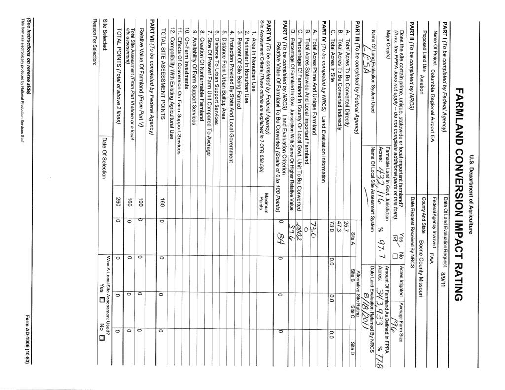
256
257 September 16, 2011 Scott Larsen Area Resource Soil Scientist USDA Natural Resources Conservation Service 6465 Highway 168, Suite B Palmyra, MO RE: Additional NRCS Alternatives Analysis to Comply with the Farmland Protection Policy Act Dear Mr. Larsen, Reynolds Smith and Hills, (RS&H) appreciates the Natural Resource Conservation Service s input on Parts II, IV and V of Form AD-1006 for the Proposed Action at (Airport). As shown in Attachment 1, RS&H has completed Parts VI and VII and calculated a total score of 164 points; resulting in the need for additional alternatives analysis. According to the NRCS correspondence sent to RS&H on August 18, 2011, if the total score is between points, two (2) alternative sites should be considered. Therefore, RS&H considered the following two alternatives for the proposed improvements to Runway 2/20 to avoid or minimize potential farmland impacts of the Proposed Action: Alternative 1: The Proposed Action with the exception of extending Runway 2/20 to the north and not acquiring 52 acres of prime farmlands. Alternative 2: The Proposed Action with the exception of shifting Runway 20 threshold 400 feet to the southwest and extending Runway 2/20 by 1,300 feet for a total of 7,400 feet in length. Attachment 2 describes the Additional NRCS Alternatives Analysis to Comply with the Farmland Protection Policy Act. This attachment describes the extensive alternatives analysis conducted as part of the Airport s Master Plan Update, further describes Alternatives 1 and 2, as well as an assessment of the potential operational impacts to the Airport and farmland soil impacts. If you would like to discuss this further, please do not hesitate to contact me at (415) or david.full@rsandh.com. Sincerely, David J. Full Vice President Aviation cc: David Alberts, RS&H Nick Kozlik, RS&H Project file
258 PART I (To be completed by Federal Agency) Name Of Project Proposed Land Use PART II (To be completed by NRCS) U.S. Department of Agriculture FARMLAND CONVERSION IMPACT RATING EA Aviation Date Of Land Evaluation Request Federal Agency Involved County And State Does the site contain prime, unique, statewide or local important farmland? (If no, the FPPA does not apply -- do not complete additional parts of this form). Date Request Received By NRCS Acres Irrigated Average Farm Size 196 Major Crop(s) Farmable Land In Govt. Jurisdiction Amount Of Farmland As Defined in FPPA Acres: 432,116 % 98 Acres: 343,933 % 78 Name Of Land Evaluation System Used Name Of Local Site Assessment System Date Land Evaluation Returned By NRCS LESA 8/18/11 PART III (To be completed by Federal Agency) A. Total Acres To Be Converted Directly B. Total Acres To Be Converted Indirectly C. Total Acres In Site PART IV (To be completed by NRCS) Land Evaluation Information A. Total Acres Prime And Unique Farmland B. Total Acres Statewide And Local Important Farmland C. Percentage Of Farmland In County Or Local Govt. Unit To Be Converted D. Percentage Of Farmland In Govt. Jurisdiction With Same Or Higher Relative Value PART V (To be completed by NRCS) Land Evaluation Criterion Relative Value Of Farmland To Be Converted (Scale of 0 to 100 Points) PART VI (To be completed by Federal Agency) Site Assessment Criteria (These criteria are explained in 7 CFR 658.5(b) 1. Area In Nonurban Use 2. Perimeter In Nonurban Use 3. Percent Of Site Being Farmed 4. Protection Provided By State And Local Government 5. Distance From Urban Builtup Area 6. Distance To Urban Support Services 7. Size Of Present Farm Unit Compared To Average 8. Creation Of Nonfarmable Farmland 9. Availability Of Farm Support Services 10. On-Farm Investments 11. Effects Of Conversion On Farm Support Services 12. Compatibility With Existing Agricultural Use Maximum Points TOTAL SITE ASSESSMENT POINTS 160 PART VII (To be completed by Federal Agency) Yes No Alternative Site Rating Site A Site B Site C Site D FAA 8/9/11 Boone County, Missouri Relative Value Of Farmland (From Part V) 100 Total Site Assessment (From Part VI above or a local site assessment) 160 TOTAL POINTS (Total of above 2 lines) 260 Site Selected: Reason For Selection: Date Of Selection Was A Local Site Assessment Used? Yes No 0 (See Instructions on reverse side) Form AD-1006 (10-83) This form was electronically produced by National Production Services Staff
259 Attachment 2 Additional NRCS Alternatives Analysis to Comply with the Farmland Protection Policy Act Environmental Assessment for Runway 2/20 and 13/31 Rehabilitation, Reconstruction and Extension, Land Acquisition for Runway 2 Departure RPZ, Roadway Realignments, and Other Airside and Landside Improvements Completion of the NRCS Form AD-1006 for the Proposed Action at resulted in a total score of 164 points. Although this value is considered an impact, it is not considered significant. As a result of this score and NRCS correspondence, two (2) alternative sites were considered to reduce the potential farmland impacts of the Proposed Action. Therefore, this attachment considers the following two alternatives for the proposed improvements to Runway 2/20: Alternative 1: The Proposed Action with the exception of extending Runway 2/20 to the north and not acquiring and converting 52 acres of prime farmlands. Alternative 2: The Proposed Action with the exception of shifting Runway 20 threshold 400 feet to the southwest and extending Runway 2/20 by 1,300 feet for a total of 7,400 feet in length. This attachment describes the extensive alternatives analysis conducted as part of the Airport s Master Plan Update, further describes Alternatives 1 and 2, as well as an assessment of the potential impacts to the Airport and farmlands. Measures that have been considered include either reducing the amount of protected farmland that the Proposed Action would convert or using farmland that has a relative lower value compared to the farmland affected as a result of the Proposed Action. MASTER P LAN UPDATE A LTERNATIVES During the development of the 2009 Airport Master Plan Update, an initial step to develop airfield alternatives was conducted to systematically identify and screen a range of possible solutions in accordance with the guidance provided by FAA Advisory Circular B Airport Master Plans. The Master Plan Update initially considered airfield configurations. Initial alternatives were narrowed by focusing on more feasible options to develop an airfield that met the goals and objectives of the Airport Sponsor (i.e., provide a safer and more efficient airport and continue supporting uninterrupted essential air service to the community). The initial alternatives were evaluated for airfield capacity and operational efficiency, best planning practices, environmental, costs and implementation/phasing. Then, through a collaborative process with the Federal Aviation Administration (FAA), the Missouri Department of Transportation (MoDOT), and Technical and Public Advisory Committees, the initial airfield alternatives were narrowed to candidate alternatives. Each of the Master Plan Update s candidate alternatives were further evaluated for possible implementation, fiscal, and environmental factors. The Master Plan Update s alternatives evaluation process narrowed the alternatives to the Proposed Action for the 2011 Environmental Assessment (EA). The Master Plan Update s candidate alternatives are being reevaluated for inclusion in the EA. The EA s alternatives analysis considers whether a candidate alternative could meet the Purpose and Need and then compares the potential impact of each alternative with respect to constructability (e.g., potential airspace impacts) and potential impacts on area residences (e.g., land acquisition and closer proximity of the airfield to area residences). Compared to the other candidate alternatives evaluated in the EA, the Proposed Action met the Purpose and Need criteria; would result in the fewest constructability impacts (no Part 77 impacts); and would not result in significant environmental issues.
260 Attachment 2 The Proposed Action was furthered assessed for potential environmental impacts (e.g., prime farmlands) in the EA. RS&H, in coordination with the NRCS, completed Form AD-1006 for the Proposed Action. The resulting score of 164 points created the need for two (2) additional alternatives to be considered by RS&H. Measures to reduce farmland impacts include either reducing the amount of off-airport farmland that the Proposed Action would convert (Alternative 1) or using farmland that has a potential relative lower value compared to the farmland affected as a result of the Proposed Action (Alternative 2). ALTERNATIVE 1 Alternative 1 includes all elements of the Proposed Action except for the 900-foot extension of Runway 2/20 to the northeast, the 52 acres of land acquisition to the northeast, and the relocation of Route H. Figure 1 presents the project elements of Alternative 1. P OTENTIAL O PERATIONAL AND F ARMLAND IMPACTS Implementation of Alternative 1 would not meet FAA safety standards due to the risk of aircraft incursion, nor meet the Purpose and Need of the Proposed Action. As shown in Figure 2, the intersecting runways at the Airport would continue to have operating conditions that do not resolve the issues identified in Figure 2. These unresolved issues could result in a runway incursion situation because Alternative 1 would require aircraft to taxi and hold short on the crosswind Runway 13/31 in order to depart Runway 20. Although the Air Traffic Control Tower (ATCT) personnel provides for separation of aircraft to mitigate the potential for intersection incursions, when services are not provided after hours, the risk increases, especially during nighttime or periods of low visibility. Aircraft departing on Runway 20 can takeoff from the point at which Taxiway B crosses Runway 20. This has three issues: 1) it reduces the runway available for takeoff distance (TODA) by 500 feet, 2) it is not the location on the runway in which arriving aircraft expect to see departing aircraft, and 3) it blocks Taxiway B. Alternative 1 also does not accommodate multiple departing and arriving traffic, particularly for taxiing operations associated with aircraft departing Runway 20. For aircraft departing Runway 20, the location at which aircraft proceed from Taxiway A to turn onto Runway 13/31 provides poor visibility for arriving Runway 31 traffic, particularly for high-wing aircraft. Alternative 1 also lacks a clear or designated runup area along Taxiway A. The intersecting runways are not in compliance with FAA design standards as described in the Airport Master Plan Update and a modification or deviation from FAA design standards is not anticipated. Alternative 1 would not require the acquisition of 52 acres of off-airport property to the northeast and would not require the relocation of Route H. When compared to the Proposed Action, implementation of Alternative 1 would result in a reduction of farmland impacts from 122 to 94 acres.
 SOURCE: RS&H, 2011 PREPARED BY: RS&H,")
261 Attachment 2 Figure 1 ALTERNATIVE 1 (site B) SOURCE: RS&H, 2011 PREPARED BY: RS&H, 2011
262 Attachment 2 Figure 2 R UNWAY INTER SECTION SOURCE: Master Plan Update, PREPARED BY: RS&H, 2009 The significant airfield operational impacts associated with Alternative 1 (i.e., potential runway incursions and reduced safety of the airfield) does not meet the Purpose and Need for the Proposed Action. Alternative 1 would reduce potential impact to area farmlands; however, this alternative would not increase the safety of the airfield and therefore is not a reasonable alternative to the Proposed Action. ALTERNATIVE 2 Alternative 2 includes all of the elements of the Proposed Action described in the EA including improvements to Runway 13/31, the taxiway connector, apron development, drainage improvements, etc. However, Alternative 2 would not construct the 900-foot extension of Runway 2/20 and the 900-foot extension of Taxiway A to the north. This alternative would shift Runway 20 threshold by 400 feet to the southwest and extend the runway pavement 1,300 feet to the southwest to achieve a final runway length of 7,400 feet. The project components of Alternative 2 are presented in Figure 3.
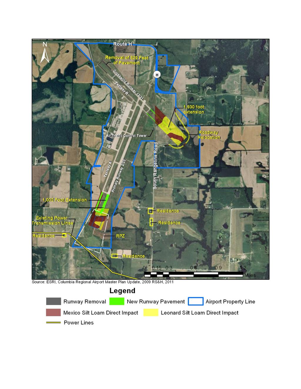
263
THIS PAGE INTENTIONALLY LEFT BLANK
 THIS PAGE INTENTIONALLY LEFT BLANK THIS PAGE INTENTIONALLY LEFT BLANK BURKE LAKEFRONT AIRPORT ENVIRONMENTAL ASSESSMENT FINAL TABLE OF CONTENTS PAGE CHAPTER ONE PROPOSED ACTION 1.1 Introduction...
FINAL ENVIRONMENTAL ASSESSMENT RUNWAY 5-23 REHABILITATION PROJECT MORRISTOWN MUNICIPAL AIRPORT
 FINAL ENVIRONMENTAL ASSESSMENT RUNWAY 5-23 REHABILITATION PROJECT MORRISTOWN MUNICIPAL AIRPORT TABLE OF CONTENTS EXECUTIVE SUMMARY ES-1 INTRODUCTION 1-1 1.1 Background 1-2 1.2 Proposed Action 1-2 1.3 Timeframe
Manhattan Regional Airport Draft Environmental Assessment. Table of Contents
 Table of Contents Page 1 PURPOSE AND NEED... 1-1 1.1 Background Information...1-1 1.2 Activity Forecasts...1-2 1.3 Purpose and Need...1-2 1.3.1 RSA and ROFA...1-3 1.3.2 Crosswind Runway...1-3 1.3.3 Parallel
CLT. Charlotte Douglas International Airport. Environmental Impact Statement Scoping Overview
 CLT Charlotte Douglas International Airport Environmental Impact Statement Scoping Overview What is the National Environmental Policy Act (NEPA)? Patrick Schneider NEPA is a federal statute that requires
Southern Ute Indian Tribe Coordination Kick-Off Meeting November 4, 2015
 Southern Ute Indian Tribe Coordination Kick-Off Meeting November 4, 2015 Awareness of the Master Plan Recommendations (Proposed Action) Understanding of the Environmental Assessment (EA) purpose and content
CLT. Charlotte Douglas International Airport. Environmental Impact Statement Scoping Overview
 CLT Charlotte Douglas International Airport Environmental Impact Statement Scoping Overview What is the National Environmental Policy Act (NEPA)? Patrick Schneider NEPA is a federal statute that requires
Federal Aviation Administration
 U.S. Department of Transportation Federal Aviation Administration DRAFT Environmental Impact Statement for Proposed Redevelopment and Extension of Runway 9R/27L March 30, 2007 Fort Lauderdale-Hollywood
October 19, 2017 Community Engagement Panel Meeting #4 Overview of Environmental Effects
 Lake Elmo Airport Environmental Assessment (EA)/ Environmental Assessment (EAW) Worksheet October 19, 2017 Community Engagement Panel Meeting #4 Overview of Environmental Effects Agenda Public Event #2
TIER 2 EIS SCOPING MEETING WELCOME TO THE FEDERAL AVIATION ADMINISTRATION SCOPING MEETING
 TIER 2 EIS SCOPING MEETING WELCOME TO THE FEDERAL AVIATION ADMINISTRATION SCOPING MEETING TIER 2 EIS OVERVIEW SOUTH SUBURBAN INAUGURAL AIRPORT ENVIRONMENTAL IMPACT STATEMENT The proposed, (SSA) will require
Draft Environmental Assessment Terminal B/C Redevelopment, Secure National Hall, and Related Improvements
 JUNE 2016 RONALD REAGAN WASHINGTON NATIONAL AIRPORT Draft Environmental Assessment Terminal B/C Redevelopment, Secure National Hall, and Related Improvements PREPARED BY: Ricondo & Associates, Inc. IN
Updates on FAA Order F. Agenda. Communicate FAA Order Updates. Educate attendees on the changes to FAA Order
 Updates on FAA Order 1050.1F Rhonda Solomon March 3, 2015 Airports Conference 2015 Agenda Communicate FAA Order 1050.1 Updates Educate attendees on the changes to FAA Order 1050.1 1 1 Overview of NEPA
KANSAS CITY AVIATION DEPARTMENT. Chapter Five AIRPORT PLANS
 KANSAS CITY AVIATION DEPARTMENT Chapter Five AIRPORT PLANS AIRPORT PLANs The alternatives discussed in the previous section were reviewed by the Federal Aviation Administration (FAA), Kansas City Aviation
Agency Scoping. May 31, :00 a.m. 1:00 p.m. Environmental Impact Statement Port Columbus International Airport
 Agency Scoping Meeting 10:00 a.m. 1:00 p.m. Environmental Impact Statement Port Columbus International Airport Presented to: CMH EIS Agencies By: FAA Consultant, Landrum & Brown Date: Agenda I. History,
EXECUTIVE SUMMARY ES.1 BACKGROUND ES.2 PURPOSE AND NEED FOR THE PROPOSED PROJECT
 EXECUTIVE SUMMARY ES.1 BACKGROUND The purpose of this Draft Environmental Report (DEIR) is the implementation of improvement projects at Charles M. Schulz Sonoma County Airport (the Airport). The improvement
SUMMARY S.1 ENVIRONMENTAL REVIEW PROCESS TUCSON INTERNATIONAL AIRPORT ENVIRONMENTAL IMPACT STATEMENT DRAFT
 SUMMARY The Federal Aviation Administration (FAA), as lead federal agency, along with the United States Air Force (USAF), and the National Guard Bureau (NGB) have prepared this Environmental Impact Statement
CHAPTER 8: ENVIRONMENTAL OVERVIEW
 CHAPTER 8: ENVIRONMENTAL OVERVIEW Introduction FAA Advisory Circular 150/5070-6B, Airport Master Plans identifies an environmental review as one of the elements of effective planning. The purpose behind
APE Area of Potential Effect. The area in which cultural resources could be affected by a proposed project.
 SECTION 9 Glossary of Terms AC - Advisory Circular ACHP Advisory Council on Historic Preservation AIP Airport Improvement Program. A federal program that provides grants-in-aid for certain types of airport
Acronyms and. Abbreviations
 Acronyms and Abbreviations Acronyms and Abbreviations AADT annual average daily traffic ACHP Advisory Council on Historic Preservation ADT average daily traffic ANC Advisory Neighborhood Commissions APE
Table of Contents. Chapter I Purpose and Need A. Summary of Purpose and Need... I-1 B. Clarification of Draft First Tier EIS...
 TOC-1 Table of Contents Summary Chapter I Purpose and Need A. Summary of Purpose and Need... I-1 B. Clarification of Draft First Tier EIS... I-2 Chapter II Strategies and Conceptual Corridors A. Summary
6 Other Considerations
 6 Other Considerations 6.1 Unavoidable Adverse Effects Under Alternatives 1, 2, and 3, there would be a change in the air emissions associated with replacing the Expeditionary VAQ EA-6B with the EA-18G
Washington Dulles International Airport EXECUTIVE SUMMARY
 EXECUTIVE SUMMARY The events of September 11, 2001 and the economic uncertainties facing commercial aviation have affected the timing of the Proposed Action. The Metropolitan Washington Airports Authority
Environmental Clearance and Next Year s Grant. Los Angeles Airport District Office. Presented by: Brenda Pérez George Buley David Cushing
 Environmental Clearance and Next Year s Grant Presented by: Los Angeles Airport District Office Brenda Pérez George Buley David Cushing ACA Conference - September 2017 Presentation Agenda Consideration
Chapter 7.0 Environmental Review
 Chapter 7.0 Environmental Review The purpose of this chapter is to conduct a general assessment of the environmental effects of the preferred alternatives described for all the projects in the 20-year
Chapter IV - Alternatives
 Chapter IV - Alternatives The purpose of this chapter is to identify and evaluate alternatives for the future development of T. F. Green Airport that address the needs identified in Chapter III, Demand/Capacity
Chapter 3 FEDERAL POLICIES SOUTH DAKOTA DRAINAGE MANUAL
 Chapter 3 FEDERAL POLICIES SOUTH DAKOTA DRAINAGE MANUAL October 2011 Table of Contents Section Page 3.1 ENVIRONMENTAL...3-1 3.2 HEALTH...3-3 3.3 HISTORIC AND ARCHEOLOGICAL PRESERVATION...3-4 3.4 LAND
9 OTHER CONSIDERATIONS REQUIRED BY NEPA
 9 OTHER CONSIDERATIONS REQUIRED BY NEPA 9.1 CONSISTENCY WITH OTHER FEDERAL, STATE, AND LOCAL LAWS, PLANS, POLICIES, AND REGULATIONS In accordance with 40 Code of Federal Regulations (CFR) section 1502.16(c),
CHAPTER 4 IDENTIFICATION AND EVALUATION OF ALTERNATIVES
 CHAPTER 4 IDENTIFICATION AND EVALUATION OF ALTERNATIVES Chapter 4, Identification and Evaluation of Alternatives presents the various alternatives considered to address the facility requirements presented
Final Environmental Assessment for the Long Term Airport Development at the Louis Armstrong New Orleans International Airport
 Final Environmental Assessment for the Long Term Airport Development at the Louis Armstrong New Orleans International Airport Prepared for the: The New Orleans Aviation Board (NOAB) and U.S. Department
Supplemental Draft Environmental Impact Statement
 Supplemental Draft Environmental Impact Statement 40 67 Highway 67 - I-40 West Pulaski County, Arkansas January, 2007 Federal Highway Administration Arkansas State Highway and Transportation Department
5.D.1 HISTORIC, ARCHITECTURAL, ARCHEOLOGICAL, AND CULTURAL RESOURCES
 5.D.1 HISTORIC, ARCHITECTURAL, ARCHEOLOGICAL, AND CULTURAL RESOURCES Section 106 of the National Historic Preservation Act (NHPA) of 1966, as amended (16 U.S.C. Section 470(f)) protects properties that
Environmental Considerations: Renewable and Conventional Power Plant Siting
 Environmental Considerations: Renewable and Conventional Power Plant Siting 2 Environmental Considerations Acronym Glossary BLM Bureau of Land Management CatEx Categorical Exclusion CAA Clean Air Act CEQ
Final Environmental Assessment Cuyahoga County Airport (CGF)
") Final Environmental Assessment Cuyahoga County Airport (CGF) Report prepared by May 6, 2015 Preface The National Environmental Policy Act (NEPA) of 1969 requires that federal agencies identify and consider
Final Environmental Assessment Cuyahoga County Airport (CGF) Report prepared by May 6, 2015 Preface The National Environmental Policy Act (NEPA) of 1969 requires that federal agencies identify and consider
Pullman-Moscow Regional Airport
 FINAL ENVIRONMENTAL ASSESSMENT Environmental Assessment to Comply with FAA Design Standards, Meet Runway Length Requirements, Improve All-Weather Reliability, and Terminal Improvements Pullman-Moscow Regional
SUMMARY S.1 ENVIRONMENTAL REVIEW PROCESS TUCSON INTERNATIONAL AIRPORT ENVIRONMENTAL IMPACT STATEMENT FINAL
 SUMMARY The Federal Aviation Administration (FAA), as lead federal agency, along with the United States Air Force (USAF), and the National Guard Bureau (NGB) have prepared this Environmental Impact Statement
Oklahoma Department of Transportation Environmental Programs Division Office Fax
 Oklahoma Department of Transportation Environmental Programs Division Office 521-3050 Fax 522-5193 Documented Categorical Exclusion (DCE) for I-40: Pavement Reconstruction and Added Lanes from the Douglas
Table of Contents. ES Executive Summary. 1.0 Introduction to the Project. 2.0 Alternatives Screened and Evaluated VOLUME 1. Page
 VOLUME 1 ES Executive Summary ES.1 Project Overview ES.2 Proposed Action ES.3 Other Alternatives Evaluated ES.4 Summary of Beneficial and Adverse Impacts of the Preferred Alternative ES.5 Other Government
Chapter 6.0 Preferred Alternative
 Chapter 6.0 PREFERRED ALTERNATIVE 6.1 Introduction The previous chapter presented the preliminary alternatives for BKV including options for extending Runway 9-27 to 8,000 feet and the continued expansion
FINDING OF NO SIGNIFICANT IMPACT (FONSI) FOR ENVIRONMENTAL ASSESSMENT (EA) OF MV-22 FACILITIES PROJECT RELOCATION
 FOR ENVIRONMENTAL ASSESSMENT (EA) OF MV-22 FACILITIES PROJECT RELOCATION") DEPARTMENT OF THE NAVY UNITED STATES MARINE CORPS FINDING OF NO SIGNIFICANT IMPACT (FONSI) FOR ENVIRONMENTAL ASSESSMENT (EA) OF Pursuant to the Council on Environmental Quality (CEQ) (Code of Federal Regulations
DEPARTMENT OF THE NAVY UNITED STATES MARINE CORPS FINDING OF NO SIGNIFICANT IMPACT (FONSI) FOR ENVIRONMENTAL ASSESSMENT (EA) OF Pursuant to the Council on Environmental Quality (CEQ) (Code of Federal Regulations
FINAL EXECUTIVE SUMMARY
 EXECUTIVE SUMMARY ES.1 ES.1.1 INTRODUCTION The Federal Aviation Administration (FAA) has prepared this Environmental Impact Statement (EIS) to analyze and disclose the potential environmental impacts resulting
Northwest State Route 138 Corridor Improvement Project
 Northwest State Route 138 Corridor Improvement Project Los Angeles County, CA DISTRICT 7- LA- 138 (PM 0.0/36.8); DISTRICT 7- LA- 05 (PM 79.5/83.1); DISTRICT 7- LA- 14 (PM 73.4/74.4) 265100/ 0700001816
Airport Master Plan Update June 14, 2017
 Airport Master Plan Update June 14, 2017 www.harveyfield.com The Master Plan is a 20-year plan to understand the needs of current and future users of the Airport. This is important to ensure that safe
Taylorsville-Murray Transit
 Taylorsville-Murray Transit Environmental Study Report April 2013 Prepared for Table of Contents Acronyms & Abbreviations... iv Executive Summary... ES 1 Chapter 1: Purpose and Need 1.1 Project Description...
CHAPTER 2 THE PROPOSED ACTION
 CHAPTER 2 THE PROPOSED ACTION 2.0 INTRODUCTION The proposed action(s) must ensure that the Afton Lincoln County Airport complies with minimum FAA and WYDOT design recommendations for a parallel taxiway
APPENDIX G LIST OF ABBREVIATIONS AND ACRONYMS
 APPENDIX G APPENDIX G - AA Alternatives Analysis 2-1 AADT average annual daily traffic 4-3 ACHP Advisory Council on Historic Preservation 3-27 ACL Atlantic Coast Line 3-37 ADA Americans with Disabilities
6.1 Introduction. 6.2 Consultation and Requirements Federal Endangered Species Act. Chapter 6 Consultation and Coordination
 Chapter 6 Consultation and Coordination 6.1 Introduction This chapter provides an overview of consultation, other requirements, and the scoping process and public involvement process for the proposed HCP/NCCP.
ACRONYMS. The following is a list of acronyms used in the EIS.
 The following is a list of acronyms used in the EIS. AANG AC ACHP ADG ADEQ ADOT AEDT AFP44 AGL AIP ALP AMARG ANCA APE APU AQCR ARFF ASA ASCE ASEP ASM ASNA AST ATC ATCT AvGas AVQ BA BAT BCT BMPs BO BOD
WELCOME TO THE FEDERAL AVIATION ADMINSTRATION SCOPING MEETING
 TIER 2 EIS MEETING December 3, 2003 WELCOME TO THE FEDERAL AVIATION ADMINSTRATION MEETING Slide 1 The Federal Aviation Administration would like to welcome you here and thank you for participating in today
SECTION 8 ENVIRONMENTAL OVERVIEW
 SECTION 8 ENVIRONMENTAL OVERVIEW The purpose of this environmental overview is to characterize the potential environmental impacts associated with the Preferred Development Plan. This overview is based
Dallas Love Field. Runway Decommissioning Environmental Assessment. City of Dallas, Texas, Department of Aviation RICONDO & ASSOCIATES, INC.
 Dallas Love Field Runway 18-36 Decommissioning Environmental Assessment PREPARED FOR: City of Dallas, Texas, Department of Aviation PREPARED BY: RICONDO & ASSOCIATES, INC. This Environmental Assessment
BOB HOPE AIRPORT REPLACEMENT TERMINAL PROJECT LOCATION BOB HOPE AIRPORT REPLACEMENT TERMINAL PROJECT DESCRIPTION
 EXHIBIT A-1 BOB HOPE AIRPORT REPLACEMENT TERMINAL PROJECT LOCATION The Burbank-Glendale-Pasadena Airport Authority (Authority) seeks to develop a 14-gate replacement passenger terminal building and related
Draft Supplemental Environmental Impact Statement
 Draft Supplemental Environmental Impact Statement December 2013 City of Seattle Department of Transportation 700 Fifth Avenue, Suite 3900 Seattle, WA 98124 TABLE OF CONTENTS Elliott Bay Seawall Project
ENVIRONMENTAL IMPACT STATEMENT (EIS)
") (EIS) FOR THE PROPOSED AIRFIELD SAFETY ENHANCEMENT PROJECT AND LAND TRANSACTIONS AT TUCSON INTERNATIONAL AIRPORT Scoping Meeting Package September 22, 2016 Tucson Executive Terminal (At the base of the
(EIS) FOR THE PROPOSED AIRFIELD SAFETY ENHANCEMENT PROJECT AND LAND TRANSACTIONS AT TUCSON INTERNATIONAL AIRPORT Scoping Meeting Package September 22, 2016 Tucson Executive Terminal (At the base of the
Public Workshop #9. October 11, 2016
 Public Workshop #9 October 11, 2016 Agenda Master Plan Status Preferred Alternative Environmental Considerations Vision 2040 Next Steps Master Plan Status Alternatives exploration and evaluation Environmental
Environmental Process at 10,000-foot Elevation
 at 10,000-foot Elevation Presented at: By: Sheri G. Lares, EPS Dakota-Minnesota ADO Date: October 25, 2017 1. How Did We Get Here? 2. What Exactly Is It? 3. Why Do We Have To Do It? 4. Can Just Anyone
Drainage Report. New Braunfels Municipal Airport. Master Plan Update 2005
 Drainage Report Master Plan Update 2005 General The Texas Department of Transportation (TxDOT), Aviation Division, retained the consulting engineering team of Parkhill, Smith & Cooper, Inc. (PSC), to prepare
ENVIRONMENTAL ASSESSMENT for Global Hawk Main Operating Base Beddown
 Final ENVIRONMENTAL ASSESSMENT for Global Hawk Main Operating Base Beddown United States Air Force Air Combat Command March 2001 ACRONYMS AND ABBREVIATIONS AB AFB AFI AGE AGL AICUZ APCD APZ AQMD AQCR ARTCC
FINAL ENVIRONMENTAL ASSESSMENT. and FINDING OF NO SIGNIFICANT IMPACT. Initiation of Turbojet Service. Friedman Memorial Airport. for the.
 FINAL ENVIRONMENTAL ASSESSMENT and FINDING OF NO SIGNIFICANT IMPACT for the Initiation of Turbojet Service for Friedman Memorial Airport Hailey, Idaho October 2012 Prepared for: U.S. Department of Transportation
Chapter 5.0 Alternatives Analysis
 Chapter 5.0 Alternatives Analysis The Master Plan process thus far has accumulated the baseline of existing airport data, presented the outlook for the future in terms of operational activity, and defined
vi Figures viii Summary S.1
 Contents Contents iii Tables vi Figures viii Summary S.1 Chapter 1: Purpose and Need Project History A.1 Project Description A.2 Project Purpose A.5 Transportation Need A.6 Highway Capacity and Congestion
actions and approvals by the Federal Aviation Administration ( FAA) and the Federal
 and the Federal") METROPOLITAN AIRPORTS COMMISSION In re MSP 2020 Improvements Final Environmental Assessment/Environmental Assessment Worksheet, Adequacy Determination, and Negative Declaration on the Need for an Environmental
METROPOLITAN AIRPORTS COMMISSION In re MSP 2020 Improvements Final Environmental Assessment/Environmental Assessment Worksheet, Adequacy Determination, and Negative Declaration on the Need for an Environmental
Raleigh Executive Jetport Master Plan Update SEPT 27, 2017
 Raleigh Executive Jetport Master Plan Update SEPT 27, 2017 Presentation Outline 1. Master Plan Purpose 2. Master Plan Process 3. Public Involvement Plan 4. Project Schedule Presentation Outline 1. Master
EVALUATION AND ACCEPTANCE OF APPLICANT PREPARED ENVIRONMENTAL INFORMATION DOCUMENT AND DRAFT FINDING OF NO SIGNIFICANT IMPACT (FONSI)
") EVALUATION AND ACCEPTANCE OF APPLICANT PREPARED ENVIRONMENTAL INFORMATION DOCUMENT AND DRAFT FINDING OF NO SIGNIFICANT IMPACT (FONSI) Wastewater Improvements Project City of Basalt Bingham County, Idaho
EVALUATION AND ACCEPTANCE OF APPLICANT PREPARED ENVIRONMENTAL INFORMATION DOCUMENT AND DRAFT FINDING OF NO SIGNIFICANT IMPACT (FONSI) Wastewater Improvements Project City of Basalt Bingham County, Idaho
6 Other Considerations Required by NEPA
 6 6.1 Consistency with Other Federal, State, and Local Laws, Plans, Policies, and Regulations In accordance with 40 Code of Federal Regulations section 1502.16(c), analysis of environmental consequences
COMBINED PUBLIC WORKSHOP/ PUBLIC HEARING
 COMBINED PUBLIC WORKSHOP/ PUBLIC HEARING Draft Environmental Assessment Five-Year Capital Improvement Program Punta Gorda Airport, Charlotte County, Florida March 2019 Project Overview The Charlotte County
Interstate 73 FEIS: I-95 to the Myrtle Beach Region Chapter 4. Public Involvement and Agency Coordination
 4-65 Interstate 73 FEIS: I-95 to the Myrtle Beach Region 4-66 Comment noted. The use of existing roadways was considered during alternative development (refer to Chapter 2, Section 2.1, page 2-1 and the
DEPARTMENT OF THE ARMY U.S. ARMY CORPS OF ENGINEERS MOBILE DISTRICT MONTGOMERY FIELD OFFICE 105 SOUTH TURNER BOULEVARD MONTGOMERY, ALABAMA 36114
 DEPARTMENT OF THE ARMY U.S. ARMY CORPS OF ENGINEERS MOBILE DISTRICT MONTGOMERY FIELD OFFICE 105 SOUTH TURNER BOULEVARD MONTGOMERY, ALABAMA 36114 CESAM-RD-N May 21, 2018 PUBLIC NOTICE NO. SAM-2006-01867-JAP
Categorical Exclusion (CE)
") Categorical Exclusion (CE) Project Information Project Name: Federal Project#: Project Number: 0029-002-135, D624, P101 Project Type: Construction UPC: 77383 Charge Number: Route Number: 29 Route Type:
Categorical Exclusion (CE) Project Information Project Name: Federal Project#: Project Number: 0029-002-135, D624, P101 Project Type: Construction UPC: 77383 Charge Number: Route Number: 29 Route Type:
Public Notice of Application for Permit
 US Army Corps of Engineers Alaska District ANCHORAGE Regulatory Division (1145) CEPOA-RD Post Office Box 6898 JBER, Alaska 99506-0898 Public Notice of Application for Permit PUBLIC NOTICE DATE: July 31,
FEDERAL HIGHWAY ADMINISTRATION RECORD OF DECISION FOR THE LYNNWOOD LINK EXTENSION
 FEDERAL HIGHWAY ADMINISTRATION RECORD OF DECISION FOR THE LYNNWOOD LINK EXTENSION AUGUST 2015 Table of Contents 1 Decision... 1 1.1 Project Description... 2 1.2 Basis for the FHWA Decision... 7 1.2.1
Chapter 2 Table of Contents 2.1 PROJECT DEVELOPMENT PROCESS
 Chapter 2 Table of Contents Section Page 2.1 PROJECT DEVELOPMENT PROCESS... 2.2 Activity No. 1: Planning... 2.2 Activity No. 2: Identification of Appropriate Level of NEPA Compliance....2.2 Activity No.
RUNWAY 4-22 MODIFICATIONS
 RONALD REAGAN WASHINGTON NATIONAL AIRPORT (DCA) RUNWAY 4-22 MODIFICATIONS ENVIRONMENTAL ASSESSMENT AND FEDERAL CONSISTENCY CERTIFICATION Prepared for: Metropolitan Washington Airports Authority One Aviation
5.0 PRELIMINARY ENVIRONMENTAL REVIEW
 5.0 PRELIMINARY ENVIRONMENTAL REVIEW 5.1 INTRODUCTION A preliminary environmental review was performed on the proposed freeway improvements that form Concept C, which encompasses the three freeway corridors
GENERAL INFORMATION ABOUT THIS DOCUMENT
 GENERAL INFORMATION ABOUT THIS DOCUMENT WHAT IS IN THIS DOCUMENT? This document is a Final Environmental Assessment (EA) for a new Airport Traffic Control Tower (ATCT) for the Phoenix-Mesa Gateway Airport
September US Army Corps of Engineers Savannah District South Atlantic Division
 ENVIRONMENTAL ASSESSMENT of Modifications to the RAW WATER STORAGE IMPOUNDMENT APPENDIX C: AGENCY COORDINATION SAVANNAH HARBOR EXPANSION PROJECT Chatham County, Georgia and Jasper County, South Carolina
An Overview and Comparison of the Tennessee Department of Transportation s Environmental Evaluation Process
 Introduction This document provides a brief overview of the policy and procedures that govern the environmental evaluation process that the Tennessee Department of Transportation (TDOT) must follow for
Chapter 5.0 Environmental Review
 Chapter 5.0 Environmental Review The purpose of this Chapter is to conduct a general assessment of the environmental effects of the preferred alternative and to define the potential extent of future environmental
Section 7 Environmental Constraints
 Section 7 Environmental Constraints i Yakima Valley Metropolitan and Regional Transportation Plan Public Comment DRAFT 1/27/2016 Environmental Constraints Analysis A programmatic-level review of potential
APPENDIX A. NEPA Assessment Checklist
 APPENDI A NEPA Assessment Checklist NEPA CHECKLIST DATE: January 12, 2009 PREPARER: Frederick Wells, RLA PIN and Project Title: Surplus Property Request Wilder Balter Partners Marketplace Town of Newburgh,
Airport Master Plan Update (AMPU) Phase 2. Scope of Work
 Phase 2. Scope of Work") BST AMPU Phase 2 Scope of Work Page 1 of 19 Belfast Municipal Airport Belfast, Maine Airport Master Plan Update (AMPU) Phase 2 Scope of Work The intent of this project is to update the 1999 Belfast Municipal
BST AMPU Phase 2 Scope of Work Page 1 of 19 Belfast Municipal Airport Belfast, Maine Airport Master Plan Update (AMPU) Phase 2 Scope of Work The intent of this project is to update the 1999 Belfast Municipal
Categorical Exclusion (CE)
") Categorical Exclusion (CE) Project Information Project Name: Rte 130 Bridge Replacement over Pedlar River Federal Project#: BR-005-3(116) Project Number: 0130-005-643, B650, C501, P101, R201 Project Type:
Categorical Exclusion (CE) Project Information Project Name: Rte 130 Bridge Replacement over Pedlar River Federal Project#: BR-005-3(116) Project Number: 0130-005-643, B650, C501, P101, R201 Project Type:
U.S. DEPARTMENT OF TRANSPORTATION FEDERAL AVIATION ADMINISTRATION Western Technical Operations Anchorage, Alaska
 U.S. DEPARTMENT OF TRANSPORTATION FEDERAL AVIATION ADMINISTRATION Western Technical Operations Anchorage, Alaska FINDING OF NO SIGNIFICANT IMPACT AND FINAL ENVIRONMENTAL ASSESSMENT RELOCATION OF THE AIRPORT
FINDING OF NO SIGNIFICANT IMPACT AND RECORD of DECISION
 DEPARTMENT OF TRANSPORTATION FEDERAL AVIATION ADMINISTRATION ORLANDO AIRPORTS DISTRICT OFFICE SOUTHERN REGION AIRPORTS DIVISION FINDING OF NO SIGNIFICANT IMPACT AND RECORD of DECISION AIRGLADES AIRPORT
DRAFT AIR QUALITY TECHNICAL MEMORANDUM
 AIR QUALITY TECHNICAL MEMORANDUM PROJECT DEVELOPMENT AND ENVIRONMENT STUDY STATE ROAD 60 GRADE SEPARATION OVER CSX RAILROAD Polk County, Florida Financial Project ID: 436559-1-22-01 Prepared for: Florida
RELATIONSHIP WITH FEDERAL LAWS AND REGULATIONS
 APPENDIX I: RELATIONSHIP WITH FEDERAL LAWS AND REGULATIONS A summary of the Federal laws, implementing regulations, and Executive Orders (EOs) applicable to the proposed actions is provided below. National
Appendix. Sample EA/EIS Scope of Work
 Appendix K Sample EA/EIS Scope of Work EA/EIS Sample Scope of Work The purpose of this Scope of Work (SOW) is to prepare an EA document pursuant to the National Environmental Policy Act (NEPA) to analyze
What s a NEPA? Modern Environmental Planning in the United States. Vanasse Hangen Brustlin, Inc.
 What s a NEPA? Modern Environmental Planning in the United States November 5, 2009 MIT Airport Planning Class Marla Engel, AICP Principal, Airports Planning Vanasse Hangen Brustlin, Inc. Modern Environmental
SUPPLEMENTAL ENVIRONMENTAL ASSESSMENT FOR THE TERMINAL REPLACEMENT PROJECT AT THE LOUIS ARMSTRONG NEW ORLEANS INTERNATIONAL AIRPORT
 TABLE OF CONTENTS SUPPLEMENTAL ENVIRONMENTAL ASSESSMENT FOR THE TERMINAL REPLACEMENT PROJECT AT THE LOUIS ARMSTRONG NEW ORLEANS INTERNATIONAL AIRPORT Chapter Page 1. INTRODUCTION 1-1 1.1 Overview of the
Defining & Completing the Planning Process
 Defining & Completing the Process How Sets the Stage for Project Development Presented to: By: Gina Mitchell, AICP Date: November 5, 2014 AirTAP: Airport Project Development Process - From Idea to Award
The existing land use surrounding North Perry Airport can be described as follows:
 7.1 INTRODUCTION This land use evaluation will accomplish the following: Identify existing and future land uses in the Airport environs; Document existing land use, future land use, and zoning around the
Final Supplemental Environmental Impact Statement
 Final Supplemental Environmental Impact Statement April 2014 City of Seattle Department of Transportation 700 Fifth Avenue, Suite 3900 Seattle, WA 98124 TABLE OF CONTENTS Elliott Bay Seawall Project TABLE
NOTICE OF OPPORTUNITY FOR PUBLIC COMMENT RELATED TO PASSENGER FACILITY CHARGE Posted June 21, 2018
 NOTICE OF OPPORTUNITY FOR PUBLIC COMMENT RELATED TO PASSENGER FACILITY CHARGE Posted June 21, 2018 The City of Atlanta is providing an opportunity for public comment until July 23, 2018 related to the
GUIDE FOR PREPARING THE ENVIRONMENTAL REPORT FOR WATER AND WASTE PROJECTS
 RUS Bulletin 1794A-602 December 1998 Version 1.0 GUIDE FOR PREPARING THE ENVIRONMENTAL REPORT FOR WATER AND WASTE PROJECTS ENGINEERING AND ENVIRONMENTAL STAFF RURAL UTILITIES SERVICE U.S. DEPARTMENT OF
August 8, 2017 Community Engagement Panel Meeting #3 Alternatives Evaluation Process & Identification of Preferred Alternatives
 Lake Elmo Airport Environmental Assessment (EA)/ Environmental Assessment (EAW) Worksheet August 8, 2017 Community Engagement Panel Meeting #3 Alternatives Evaluation Process & Identification of Preferred
Massachusetts Port Authority April 4, :00pm MEPA Scoping Meeting. Multi-Purpose Room 10 Mudge Way Bedford, MA 01730
 2012 L.G. Hanscom Field Environmental Status and Planning Report (ESPR) Scope Massachusetts Port Authority April 4, 2012 6:00pm MEPA Scoping Meeting Bedford Town Hall Multi-Purpose Room 10 Mudge Way Bedford,
Chester Bridge Environmental Assessment (EA) CAG Meeting #2. October 12, 2017
 CAG Meeting #2. October 12, 2017") Chester Bridge Environmental Assessment (EA) CAG Meeting #2 October 12, 2017 Agenda Introductions Purpose & Need review and Merger Approval Review of the Conceptual Alternatives Recap of the Public Meeting
Chester Bridge Environmental Assessment (EA) CAG Meeting #2 October 12, 2017 Agenda Introductions Purpose & Need review and Merger Approval Review of the Conceptual Alternatives Recap of the Public Meeting
Plymouth Municipal Airport Taxiway D and Master Plan Improvements
 DRAFT ENVIRONMENTAL ASSESSMENT Plymouth Municipal Airport Taxiway D and Master Plan Improvements Issued By: Federal Aviation Administration Prepared by: In Association with: DuBois & King, Inc. November
Runway Protection Zones: Incompatible Land Use Alternatives Analysis & Risk Assessment
 March 3rd, 2015 Runway Protection Zones: Incompatible Land Use Alternatives Analysis & Risk Assessment Matt Lee Vice President Landrum & Brown Cincinnati, OH Cody Meyer Consultant Landrum & Brown Cincinnati,
J O I N T P U B L I C N O T I C E
 J O I N T P U B L I C N O T I C E CHARLESTON DISTRICT, CORPS OF ENGINEERS 69A Hagood Avenue Charleston, South Carolina 29403-5107 and THE S.C. DEPARTMENT OF HEALTH AND ENVIRONMENTAL CONTROL Office of Environmental
Public Notice of Application for Permit
 US Army Corps of Engineers Alaska District ANCHORAGE Regulatory Division (1145) CEPOA-RD Post Office Box 6898 JBER, Alaska 99506-0898 Public Notice of Application for Permit PUBLIC NOTICE DATE: 06/02/2017
FINDING OF NO SIGNIFICANT IMPACT
 U.S. DEPARTMENT OF TRANSPORTATION FEDERAL AVIATION ADMINISTRATION WESTERN-PACIFIC REGION SAN FRANCISCO AIRPORTS DISTRICT OFFICE FINDING OF NO SIGNIFICANT IMPACT SAN FRANCISCO INTERNATIONAL AIRPORT RENTAL