Rainfall - runoff: Unit Hydrograph. Manuel Gómez Valentín E.T.S. Ing. Caminos, Canales y Puertos de Barcelona
|
|
|
- Morgan Roberts
- 6 years ago
- Views:
Transcription
1 Rainfall - runoff: Unit Hydrograph Manuel Gómez Valentín E.T.S. ng. Caminos, Canales y Puertos de Barcelona

2 Options in many commercial codes,, HMS and others HMS Menu Transform method, User specified, SCS, etc
3 Rainfall - runoff Different options Unit hydrograph (most popular) Lumped (global) model Hydrological response at the basin outlet from an effective rainfall, mm, duration D minutes, uniformly distributed all over the basin
4 UH Hipothesis Linear response Time invariant (rain event) Effective rainfall mm effective rainfall Unit hydrograph, duration d minutes Unit hydrograph, Duration t d Tb t Tiempo
5 Problems in the application Lack of real data to obtain it We need to use synthetic UH
6 The Basic Process Unit Hydrographs Necessary for a single basin Excess Precip. Model Excess Precip. Excess Precip. Basin Routing UHG Methods Runoff Hydrograph Runoff Hydrograph Stream and/or Reservoir Routing Downstream Hydrograph
7 Proposal of the HU Sherman - 93 Horton Wisler & Brater the hydrograph of surface runoff resulting from a relatively short, intense rain, called a unit storm Standardly used in most professional codes for rural basins
8 Unit Hydrograph Lingo Duration Lag Time Time of Concentration Rising Limb Recession Limb (falling limb) Peak Flow Time to Peak (rise time) Recession Curve Separation Base flow
9 Graphical Representation Duration Lag Time Time of Concentration Rising Limb Recession Limb (falling limb) Peak Flow Time to Peak (rise time) Recession Curve Separation Base flow Duration of excess precip. Lag time Base flow Time of concentration
10 How to get the UH Field data measurements (t), (t) Approach with synthetic unit hydrographs SCS (NRCS) Time - area curve (Clark, 945)
11 Unit Hydrograph Hydrological response at the basin outlet from an effective rainfall, mm, duration D minutes, uniformly distributed all over the basin Puntos capitales: -inch -mm of effective rainfall Uniformly distributed in space and time (duration D minutes) Different hydrographs for different durations
12 How to use the UH Graphical process Hyetograph defined with time steps d Use the unit hydrograph for duration d Addition of different sub-hydrographs
13 Matrix approach Prepare matrix P and U Direct operation u u u u u u u u How How to to use use the the UH UH
14 UH obtention We need field measurements Rainfall Runoff hydrograph at the basin outlet We measure the total rainfall (effective rainfall is estimated ) SOURCE OF UNCERTANTY Other problems (errors, spatial distrib.)
15 UH obtention Rules of Thumb : the storm should be fairly uniform in nature and the excess precipitation should be equally as uniform throughout the basin. This may require the initial conditions throughout the basin to be spatially similar. Second, the storm should be relatively constant in time, meaning that there should be no breaks or periods of no precipitation. Finally, the storm should produce at least an inch ( mm) of excess precipitation (the area under the hydrograph after correcting for baseflow).
16 Deriving a UHG from a Deriving a UHG from a Storm Flow (cfs) Precipitation (inches) Time (hrs.)
17 Derived Unit Hydrograph Total Hydrograph Surface Response 3.. Baseflow
18 UH obtention Measured (t), surface and groundwater response We want just the surface response Surface Response Baseflow
19 Separation of Baseflow... generally accepted that the inflection point on the recession limb of a hydrograph is the result of a change in the controlling physical processes of the excess precipitation flowing to the basin outlet. n this example, baseflow is considered to be a straight line connecting that point at which the hydrograph begins to rise rapidly and the inflection point on the recession side of the hydrograph. the inflection point may be found by plotting the hydrograph in semi-log fashion with flow being plotted on the log scale and noting the time at which the recession side fits a straight line.
20 Semi-log Plot Groundwater response, exponential Use log paper to determine the separation point Flow (cfs) Recession side of hydrograph becomes linear at approximately hour Time (hrs.)
21 Hydrograph & Baseflow Flow (cfs) Time (hrs.)
22 33 Separate Baseflow 5 5 Flow (cfs) Time (hrs.)
23 Separation of Baseflow f no significant contribution from groundwaters, use a horizontal straight line Constant base flow
24 UH UH from from field field data data Matrix approach u u u u PU
25 UH from field data Considering a matrix algebra, we can obtain the vector U, from vectos and matrix P PU PU P T PU P T U T T P P P
26 UH of D D from D minutes UH Sometimes you have UH for duration D, but you need the D UH duration Use of S-curve Just for real UH, not synthetic ones
27 S hydrograph 6. Consider a 5. very long, constant rain event Flow (cfs) Addition of UH, duration D ntensity /D mm/h.. Hydrological Time (hrs.) response?
28 S curve
29 UH of D D from D minutes UH From D minutes UH, establish S curve Move D minutes the S-curve Sustract both hydrographs Convert to unit rainfall, the obtained hydrograph ( mm rainfall)
30 Problems of the UH obtention Rain event selection Errors in rainfall or runoff measurements Non-uniform rain events Use of more than event to obtain UH Make an average of the UH Optimization methods to obtain the UH from several rain event at the same time
31 Average Several UHG s t is suggested that several unit hydrographs be derived and averaged. The unit hydrographs must be of the same duration in order to be properly averaged. t is often not sufficient to simply average the ordinates of the unit hydrographs in order to obtain the final unit hydrograph. A numerical average of several unit hydrographs which are different shapes may result in an unrepresentative unit hydrograph. t is often recommended to plot the unit hydrographs that are to be averaged. Then an average or representative unit hydrograph should be sketched or fitted to the plotted unit hydrographs. Finally, the average unit hydrograph must have a volume of mm of runoff for the basin.
32 Synthetic UHG s SCS Clark (Time-area method)
33 SCS SUH SCS proposal Simple Basin of regular shapes Single peak /peak SCS Dimensionless UHG Features Flow ratios Cum. Mass T/Tpeak
34 Triangular SHU D SCS Dimensionless UHG & Triangular Representation. Excess Precipitation T lag /peak.8.6 Point of nflection Flow ratios Cum. Mass Triangular T c.4.. T p. T b T/Tpeak
35 Dimensionless Ratios Discharge Ratios (q/q p ) Time Ratios (t/t p ) Mass Curve Ratios ( a /)
36 Triangular Representation D SCS Dimensionless UHG & Triangular Representation Tb.67 x T p. T lag Excess Precipitation = q q p T q p p T + r = T q T p T b r - T = +T p r p q x x A x = T p +T r.67 x p (T p +T T r p ) p The is the conversion used for delivering - inch of runoff (the area under the unit hydrograph) q p 484 A = T p /peak T c Point of nflection Flow ratios Cum. Mass Triangular. T p T b T/Tpeak from -square mile in -hour (36 seconds).
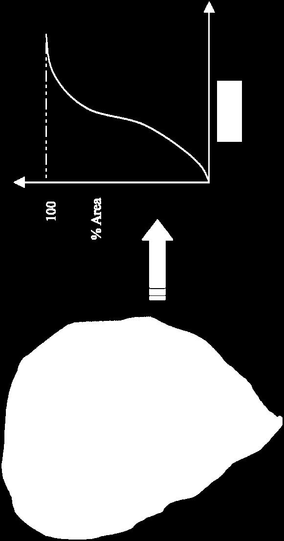
37 Duration & Timing? Again from the triangle T p = D + L L.6*T c L = Lag time T c D.7 T p D +.6 T c =T For estimation purposes should be around : p D.33 Tc To be used with SCS concept and expressions
38 Time of Concentration Regression Eqs. Segmental Approach
39 Time of Concentration n Spain, we use the Témez s formula Different concept for Tc than the SCS Modify expressions for SHU, SCS
40 A Regression Equation L 8. ( S ) 7. T lag 9(% Slope) 5. where : T lag = lag time in hours L = Length of the longest drainage path in feet S = (/CN) - (CN=curve number) %Slope = The average watershed slope in % T c.3( J L.76 ).5
41 Tc,, is it always the same? Tlag L 8. ( S ) 7. 9(% Slope) 5. T c.3( J L.76 ).5 Tc for SCS and Tc for other expressions are not the same T c for SCS, time to inflexion point of the UH Tc as time needed to exit the basin from the farthest point lag ' c T.6 T. 35 T c
42 Clark, synthetic UH Propossed by Clark Considering the basin shape, not just the total area Consider delays attributed to sub-surface runoff Need to be applied in non regular shape basins

43 Clark - Time-Area
44 Time-Area Synthetic UH, equal form as the time-area curve t can show more than one peak % % Area Time of conc. Time Time


45 Additional delay Presence of sub-surface runoff Runoff shows an additional delay, that can not be explained just for surface runoff
46 Reservoir model for the delay Conceptual model Assume that additional delay is equal to the produced by a water reservoir (UH Clark) ds dt K
47 Storage description General approach S K K Simplified to a linear reservoir model K has dimensions of time S K K n n K T
48 Mathematical description f K is contant in time K d dt We can solve the diff. Equation as: ( t ) t ( ) t K e K d
49 Practical Practical application application A finite difference scheme can be used From an initial condition, and from the values of the previous hydrograph we can proceed as: t K t K t K t
50 K values We need to estimate the K value Best approach, field data (, ) From correlations obtained in other Proposed K =.75 Tc
51 Basin application Basin 9 Km, Tc 8 hours K= 5.5 hours Time step, or hours
52 Basin geometry 8 7 socrones Area Accum. Area Accum Area # (km) (km ) Time (hrs) TOTAL
53 Time area curve Area (Km) ncremental Area (sqaure miles) Time ncrement (hrs) 5
54 Time accumulated area 9 8 Cumulative Area (sqaure miles) Watershed Boundary sochrone Time (hrs) 5
55 No time / area curve? TA i.44t i.5 for ( Ti.5) TA i.44( T ) i.5 for (.5 Ti.) U.S. Army Corps of Engineers (HEC 99) What about if the synthetic curve does not match the real one?
56 SUH, comments SUH is an approach to the real UH, could be good or not SHU Clark, problems to estimate K SHU SCS, one peak value, can only be applied to basins with regular shape You must make your choice according the basin characteristics
Runoff Hydrographs. The Unit Hydrograph Approach
 Runoff Hydrographs The Unit Hydrograph Approach Announcements HW#6 assigned Storm Water Hydrographs Graphically represent runoff rates vs. time Peak runoff rates Volume of runoff Measured hydrographs are
Module 3. Lecture 4: Introduction to unit hydrograph
 Lecture 4: Introduction to unit hydrograph (UH) The unit hydrograph is the unit pulse response function of a linear hydrologic system. First proposed by Sherman (1932), the unit hydrograph (originally
Engineering Hydrology. Class 16: Direct Runoff (DRO) and Unit Hydrographs
 and Unit Hydrographs") Engineering Hydrology Class 16: and s Topics and Goals: 1. Calculate volume of DRO from a hydrograph; 2. Complete all steps to develop a. Class 14: s? HG? Develop Ocean Class 14: s? HG? Develop Timing
Engineering Hydrology Class 16: and s Topics and Goals: 1. Calculate volume of DRO from a hydrograph; 2. Complete all steps to develop a. Class 14: s? HG? Develop Ocean Class 14: s? HG? Develop Timing
Module 3. Lecture 6: Synthetic unit hydrograph
 Lecture 6: Synthetic unit hydrograph Synthetic Unit Hydrograph In India, only a small number of streams are gauged (i.e., stream flows due to single and multiple storms, are measured) There are many drainage
Introduction to Hydrology, Part 2. Notes, Handouts
 Introduction to Hydrology, Part 2 Notes, Handouts Precipitation Much of hydrology deals with precipitation How much? How frequently/infrequently? What form? How quickly? Seasonal variation? Drought frequency?
CIVE22 BASIC HYDROLOGY Jorge A. Ramírez Homework No 7
 Hydrologic Science and Engineering Civil and Environmental Engineering Department Fort Collins, CO 80523-1372 (970) 491-7621 CIVE22 BASIC HYDROLOGY Jorge A. Ramírez Homework No 7 1. Obtain a Unit Hydrograph
Learning objectives. Upon successful completion of this lecture, the participants will be able to describe:
 Solomon Seyoum Learning objectives Upon successful completion of this lecture, the participants will be able to describe: The different approaches for estimating peak runoff for urban drainage network
Peak discharge computation
 Ia/P 4 Peak Dischage Method Graphical Peak Discharge Method This chapter presents the Graphical Peak Discharge method for computing peak discharge from rural and urban areas. The Graphical method was developed
What is runoff? Runoff. Runoff is often defined as the portion of rainfall, that runs over and under the soil surface toward the stream
 What is runoff? Runoff Runoff is often defined as the portion of rainfall, that runs over and under the soil surface toward the stream 1 COMPONENTS OF Runoff or STREAM FLOW 2 Cont. The types of runoff
ENGINEERING HYDROLOGY
 ENGINEERING HYDROLOGY Prof. Rajesh Bhagat Asst. Professor Civil Engineering Department Yeshwantrao Chavan College Of Engineering Nagpur B. E. (Civil Engg.) M. Tech. (Enviro. Engg.) GCOE, Amravati VNIT,
Autumn semester of Prof. Kim, Joong Hoon
 1 Autumn semester of 2010 Prof. Kim, Joong Hoon Water Resources Hydrosystems System Engineering Laboratory Laboratory 2 A. HEC (Hydrologic Engineering Center) 1 Established in the U.S. Army Corps of Engineers(USACE)
Introduction, HYDROGRAPHS
 HYDROGRAPHS Sequence of lecture Introduction Types of Hydrograph Components of Hydrograph Effective Rainfall Basin Lag or Time Lag Parts of Hydrograph Hydrograph Analysis Factors Affecting Hydrograph Shape
Runoff Processes. Daene C. McKinney
 CE 374 K Hydrology Runoff Processes Daene C. McKinney Watershed Watershed Area draining to a stream Streamflow generated by water entering surface channels Affected by Physical, vegetative, and climatic
1 n. Flow direction Raster DEM. Spatial analyst slope DEM (%) slope DEM / 100 (actual slope) Flow accumulation
 slope DEM / 100 (actual slope) Flow accumulation") 1 v= R S n 2/3 1/2 DEM Flow direction Raster Spatial analyst slope DEM (%) Flow accumulation slope DEM / 100 (actual slope) 0 = no cell contributing 215 = 215 cell contributing towards that cell sqrt (actual
1 v= R S n 2/3 1/2 DEM Flow direction Raster Spatial analyst slope DEM (%) Flow accumulation slope DEM / 100 (actual slope) 0 = no cell contributing 215 = 215 cell contributing towards that cell sqrt (actual
Development of a GIS Tool for Rainfall-Runoff Estimation
 Development of a GIS Tool for Rainfall-Runoff Estimation Ashraf M. Elmoustafa * M. E. Shalaby Ahmed A. Hassan A.H. El-Nahry Irrigation and Hydraulics Department, Ain Shams University, Egypt NARSS, Egypt
1. Stream Network. The most common approach to quantitatively describing stream networks was postulated by Strahler (1952).
.") 1. Stream Network The most common approach to quantitatively describing stream networks was postulated by Strahler (1952). First Order Streams streams with no tributaries. Second Order Streams begin at
1. Stream Network The most common approach to quantitatively describing stream networks was postulated by Strahler (1952). First Order Streams streams with no tributaries. Second Order Streams begin at
2
 1 2 3 4 5 6 The program is designed for surface water hydrology simulation. It includes components for representing precipitation, evaporation, and snowmelt; the atmospheric conditions over a watershed.
APPENDIX IV. APPROVED METHODS FOR QUANTIFYING HYDROLOGIC CONDITIONS OF CONCERN (NORTH ORANGE COUNTY)
") APPENDIX IV. APPROVED METHODS FOR QUANTIFYING HYDROLOGIC CONDITIONS OF CONCERN (NORTH ORANGE COUNTY) Hydromodification design criteria for the North Orange County permit area are based on the 2- yr, 24-hr
APPENDIX IV. APPROVED METHODS FOR QUANTIFYING HYDROLOGIC CONDITIONS OF CONCERN (NORTH ORANGE COUNTY) Hydromodification design criteria for the North Orange County permit area are based on the 2- yr, 24-hr
International Journal of Scientific & Engineering Research, Volume 5, Issue 7, July-2014 ISSN Sruthy Nattuvetty Manoharan
 ISSN 2229-5518 210 Sruthy Nattuvetty Manoharan Department of Civil Engineering Government Engineering College, Thrissur Thrissur, 680009 sruthy.n.m@gmail.com a spatially distributed excess rainfall. It
FAST WATER / SLOW WATER AN EVALUATION OF ESTIMATING TIME FOR STORMWATER RUNOFF
 FAST WATER / SLOW WATER AN EVALUATION OF ESTIMATING TIME FOR STORMWATER RUNOFF Factors Affecting Stormwater Runoff: Rainfall intensity % Impervious surfaces Watershed size Slope Soil type, soil compaction
SECTION III: WATERSHED TECHNICAL ANALYSIS
 Trout Creek Watershed Stormwater Management Plan SECTION III: WATERSHED TECHNICAL ANALYSIS A. Watershed Modeling An initial step this study of the Trout Creek watershed was the selection of a stormwater
Norman Maclean Snowmelt Flow rate Storm flows fs (c flow m a tre S
 Eventually, all things merge into one, and a river runs through it. Norman Maclean Understanding Streamflow ADEQ SW Short Course June 13, 213 Phoenix, AZ Hydrographs Discharge (Q) USGS flow data & plots
Introduction to HEC HMS. Daene C. McKinney
 CE 374 K Hydrology Introduction to HEC HMS Daene C. McKinney Hydrologic Engineering Center U.S. Army Corps ofengineers (USACE) Hydrologic Engineering Center (HEC) Formed 1964 to institutionalize the technical
5/25/2017. Overview. Flood Risk Study Components HYDROLOGIC MODEL (HEC-HMS) CALIBRATION FOR FLOOD RISK STUDIES. Hydraulics. Outcome or Impacts
 CALIBRATION FOR FLOOD RISK STUDIES. Hydraulics. Outcome or Impacts") HYDROLOGIC MODEL (HEC-HMS) CALIBRATION FOR FLOOD RISK STUDIES C. Landon Erickson, P.E.,CFM Water Resources Engineer USACE, Fort Worth District April 27 th, 2017 US Army Corps of Engineers Overview Flood
HYDROLOGIC MODEL (HEC-HMS) CALIBRATION FOR FLOOD RISK STUDIES C. Landon Erickson, P.E.,CFM Water Resources Engineer USACE, Fort Worth District April 27 th, 2017 US Army Corps of Engineers Overview Flood
MODULE 1 RUNOFF HYDROGRAPHS WORKSHEET 1. Precipitation
 Watershed MODULE 1 RUNOFF HYDROGRAPHS WORKSHEET 1 A watershed is an area of land thaaptures rainfall and other precipitation and funnels it to a lake or stream or wetland. The area within the watershed
Overview of NRCS (SCS) TR-20 By Dr. R.M. Ragan
 TR-20 By Dr. R.M. Ragan") Overview of NRCS (SCS) TR-20 By Dr. R.M. Ragan TR-20 is a computer program for the simulation of runoff occurring from a single storm event. The program develops flood hydrographs from runoff and routes
Overview of NRCS (SCS) TR-20 By Dr. R.M. Ragan TR-20 is a computer program for the simulation of runoff occurring from a single storm event. The program develops flood hydrographs from runoff and routes
SOUTHEAST TEXAS CONTINUING EDUCATION
 EXAM No. 118 FLOOD - RUNOFF ANALYSIS 1. Information gained from flood - runoff analysis includes which one: A. Stage, discharge, volume. B. Measure depth, volume. C. Velocity, depth, storm occurrence.
Drainage Analysis. Appendix E
 Drainage Analysis Appendix E The existing and proposed storm drainage systems have been modeled with Bentley CivilStorm V8 computer modeling software. The peak stormwater discharge was determined for
Hydrologic Calibration:
 Hydrologic Calibration: UPDATE OF EFFECTIVE HYDROLOGY FOR MARYS CREEK October 2010 Agenda Background Hydrologic model Calibrated rainfall Hydrologic calibration 100 year discharges, Existing Conditions
HYDROLOGIC MODELING CONSISTENCY AND SENSITIVITY TO WATERSHED SIZE
 HYDROLOGIC MODELING CONSISTENCY AND SENSITIVITY TO WATERSHED SIZE by James C.Y. Guo. Professor, Civil Engineering, U. Of Colorado at Denver, James.Guo@cudenver.edu.. And Eric Hsu, Project Engineer, Parson
To estimate the magnitude of a flood peak the following alternative methods available: 1. Rational method 2. Empirical method
 Methods for estimating flood To estimate the magnitude of a flood peak the following alternative methods available: 1. Rational method 2. Empirical method 3. Unit-hydrograph technique 4. Flood-frequency
San Luis Obispo Creek Watershed Hydrologic Model Inputs
 Jeff Werst San Luis Obispo County Department of Public Works 1050 Monterey Street San Luis Obispo CA 93408 December 14, 2007 Subject: San Luis Obispo Creek Watershed Hydrology and Hydraulic Model Dear
5/11/2007. WinTR-55 for Plan Reviewers Small Watershed Hydrology Hydrology Terms and Definitions
 WinTR-55 for Plan Reviewers Small Watershed Hydrology Hydrology Terms and Definitions 1 Course Outline Overview Review of Hydrology Terms and Definitions Modeling Single Sub-area Watersheds Multiple Sub-area
Engineering Hydrology Class 3
 Engineering Hydrology Class 3 Topics and Goals: I.Develop s (estimate precipitation) II.Develop simple constant intensity design storm III.Develop SCS design storm Ocean s Why do we want to derive the?
Introduction. Keywords: Oil Palm, hydrology, HEC-HMS, HEC-RAS. a * b*
 The Effect of Land Changes Towards in Sg. Pandan Perwira Bin Khusairi Rahman 1,a* and Kamarul Azlan bin Mohd Nasir 1,b 1 Faculty of Civil Engineering, Universiti Teknologi Malaysia, Malaysia a * wirakhusairirahman@gmail.com,
Hydrologic Study Report for Single Lot Detention Basin Analysis
 Hydrologic Study Report for Single Lot Detention Basin Analysis Prepared for: City of Vista, California August 18, 2006 Tory R. Walker, R.C.E. 45005 President W.O. 116-01 01/23/2007 Table of Contents Page
5/11/2007. WinTR-55 for Plan Reviews Small Watershed Hydrology Overview
 WinTR-55 for Plan Reviews Small Watershed Hydrology Overview 1 Overview Course Outline Historical Background Program Description Model Capabilities and Limitations This is the Overview portion of the training.
Hydrologic Engineering Center Hydrologic Modeling System (HEC-HMS) Sunil KUMAR Director, National Water Academy
 Sunil KUMAR Director, National Water Academy") Hydrologic Engineering Center Hydrologic Modeling System (HEC-HMS) Sunil KUMAR Director, National Water Academy 22 April 2015 NWA, Pune Exercise Objective: To determine hydrological Response of the given
Hydrologic Engineering Center Hydrologic Modeling System (HEC-HMS) Sunil KUMAR Director, National Water Academy 22 April 2015 NWA, Pune Exercise Objective: To determine hydrological Response of the given
INFLOW DESIGN FLOOD CONTROL SYSTEM PLAN 40 C.F.R. PART PLANT YATES ASH POND 3 (AP-3) GEORGIA POWER COMPANY
 GEORGIA POWER COMPANY") INFLOW DESIGN FLOOD CONTROL SYSTEM PLAN 40 C.F.R. PART 257.82 PLANT YATES ASH POND 3 (AP-3) GEORGIA POWER COMPANY EPA s Disposal of Coal Combustion Residuals from Electric Utilities Final Rule (40 C.F.R.
INFLOW DESIGN FLOOD CONTROL SYSTEM PLAN 40 C.F.R. PART 257.82 PLANT YATES ASH POND 3 (AP-3) GEORGIA POWER COMPANY EPA s Disposal of Coal Combustion Residuals from Electric Utilities Final Rule (40 C.F.R.
Synthesis of Unit Hydrographs for Texas Watersheds
 Synthesis of Unit Hydrographs for Texas Watersheds Theodore G. Cleveland, UH William H. Asquith, USGS David B. Thompson, R.O. Anderson Xing Fang, Auburn University July 17, 2007 Acknowledgements Research
Derivation of Unit Hydrograph (UH) Module Objectives. Unit Hydrograph. Assumptions in Unit Hydrograph theory. Derivation of Unit Hydrograph
 Module Objectives. Unit Hydrograph. Assumptions in Unit Hydrograph theory. Derivation of Unit Hydrograph") PRINT VERSION MODULE Derivation of Unit Hydrograph (UH) Module Objectives References Unit Hydrograph Assumptions in Unit Hydrograph theory Derivation of Unit Hydrograph Unit Hydrograph from a Hydrograph
PRINT VERSION MODULE Derivation of Unit Hydrograph (UH) Module Objectives References Unit Hydrograph Assumptions in Unit Hydrograph theory Derivation of Unit Hydrograph Unit Hydrograph from a Hydrograph
The Texas A&M University and U.S. Bureau of Reclamation Hydrologic Modeling Inventory (HMI) Questionnaire
 Questionnaire") The Texas A&M University and U.S. Bureau of Reclamation Hydrologic Modeling Inventory (HMI) Questionnaire May 4, 2010 Name of Model, Date, Version Number Dynamic Watershed Simulation Model (DWSM) 2002
The Texas A&M University and U.S. Bureau of Reclamation Hydrologic Modeling Inventory (HMI) Questionnaire May 4, 2010 Name of Model, Date, Version Number Dynamic Watershed Simulation Model (DWSM) 2002
Example 3. Elementary HEC-HMS Model. Purpose. Illustrate the steps to create a functioning precipitation-runoff model in HEC-HMS.
 Example 3 Elementary HEC-HMS Model Purpose Illustrate the steps to create a functioning precipitation-runoff model in HEC-HMS. The example is elementary in the sense that only a small set of HEC-HMS capabilities
Technical Memorandum
 Tucson Office 3031 West Ina Road Tucson, AZ 85741 Tel 520.297.7723 Fax 520.297.7724 www.tetratech.com Technical Memorandum To: Kathy Arnold From: Greg Hemmen, P.E. Company: Rosemont Copper Company Date:
Rainfall, Runoff and Peak Flows: Calibration of Hydrologic Design Methods for the Kansas City Area
 Rainfall, Runoff and Peak Flows: Calibration of Hydrologic Design Methods for the Kansas City Area Bruce McEnroe, Bryan Young, Ricardo Gamarra and Ryan Pohl Department of Civil, Environmental, and Architectural
Chapter H. Introduction to Surface Water Hydrology and Drainage for Engineering Purposes
 Chapter H. Introduction to Surface Water Hydrology and Drainage for Engineering Purposes As seen in Figure H.1, hydrology is a complex science that deals with the movement of water between various stages
IJSER. within the watershed during a specific period. It is constructed
 International Journal of Scientific & Engineering Research, Volume 5, Issue 7, July-014 ISSN 9-5518 306 within the watershed during a specific period. It is constructed I. INTRODUCTION In many instances,
Development of Runoff Depth Map for Alberta
 Development of Runoff Depth Map for Alberta Introduction Assessment of basin runoff potential is an important component of the Hydrotechnical Design Guidelines for highway projects interacting with streams.
Rational Method Hydrological Calculations with Excel COURSE CONTENT
 Rational Method Hydrological Calculations with Excel Harlan H. Bengtson, PhD, P.E. COURSE CONTENT 1. Introduction Calculation of peak storm water runoff rate from a drainage area is often done with the
Modeling the Hydrologic Impacts of Control Structures Utilizing LiDAR, ICPR, and GIS Technologies
 Modeling the Hydrologic Impacts of Control Structures Utilizing LiDAR, ICPR, and GIS Technologies Keanan Bell NorthStar June 12, 2015 Project began in 2010 as a Hydrology Assessment and Conceptual Restoration
INFLOW DESIGN FLOOD CONTROL SYSTEM PLAN PLANT BARRY ASH POND ALABAMA POWER COMPANY
 INFLOW DESIGN FLOOD CONTROL SYSTEM PLAN PLANT BARRY ASH POND ALABAMA POWER COMPANY Section 257.82 of EPA s regulations requires the owner or operator of an existing or new CCR surface impoundment or any
Cumulative Precipitation
 Problem 1: Hyetograph Construction (4 pts) Use the rainfall information below to construct both the cumulative (inch) and incremental (in/hr) hyetographs. Note: the incremental hyetograph must be formatted
UNIT HYDROGRAPH AND EFFECTIVE RAINFALL S INFLUENCE OVER THE STORM RUNOFF HYDROGRAPH
 UNIT HYDROGRAPH AND EFFECTIVE RAINFALL S INFLUENCE OVER THE STORM RUNOFF HYDROGRAPH INTRODUCTION Water is a common chemical substance essential for the existence of life and exhibits many notable and unique
DETENTION BASIN DESIGN USING RATIONAL HYDROGRAPHS
 DETENTION BASIN DESIGN USING RATIONAL HYDROGRAPHS By Thomas F. Smith, P.E., P.L.S. Bercek and Smith Engineering, Inc. www.bercekandsmith.com tfsmith2@bercekandsmith.com 1 Topics Covered: 2 1 Attributed
CLARK COUNTY REGIONAL FLOOD CONTROL DISTRICT HYDROLOGIC CRITERIA AND DRAINAGE DESIGN MANUAL
 CLARK COUNTY REGIONAL FLOOD CONTROL DISTRICT HYDROLOGIC CRITERIA AND DRAINAGE DESIGN MANUAL SECTION 600 STORM RUNOFF TABLE OF CONTENTS 601 INTRODUCTION 603 601.1 - Basin Characteristics 603 602 TIME OF
UPDATE OF ARC TP108 RUN-OFF CALCULATION GUIDELINE
 UPDATE OF ARC TP108 RUN-OFF CALCULATION GUIDELINE Bodo Hellberg, Stormwater Action Team, Auckland Regional Council Matthew Davis, Stormwater Action Team, Auckland Regional Council ABSTRACT This paper focuses
EXPLICIT FUNCTIONS FOR IMPLICIT RESERVOIR ROUTING
 Guo, James C.Y. (2004). Hydrology-Based Approach to Storm Water Detention Design Using New Routing Schemes, ASCE J. of Hydrologic Engineering, Vol 9, No. 4, July/August Guo, James C.Y. (2000). Storm Hydrographs
HYDROLOGY WORKSHEET 1 PRECIPITATION
 HYDROLOGY WORKSHEET 1 PRECIPITATION A watershed is an area of land that captures rainfall and other precipitation and funnels it to a lake or stream or wetland. The area within the watershed where the
CONTINUOUS RAINFALL-RUN OFF SIMULATION USING SMA ALGORITHM
 CONTINUOUS RAINFALL-RUN OFF SIMULATION USING SMA ALGORITHM INTRODUCTION Dr. R N Sankhua Director, NWA, CWC, Pune In this continuous rainfall-runoff simulation, we will perform a continuous or long-term
Reservoir on the Rio Boba
 Reservoir on the Rio Boba Michael J. Burns II Guillermo Bustamante J. James Peterson Executive Summary The National Institute of Water Resources in the Dominican Republic (INDRHI) plans to construct a
Physically-based Distributed Hydrologic Modeling
 Physically-based Distributed Hydrologic Modeling Goal of Phys.-based Distrib. Hydrologic Modeling To date we have learned about: Key forcings at land surface (precipitation/net radiation) Physical processes
DERIVATION AND CALIBRATION OF VOLUME-BASED RUNOFF COEFFICIENTS FOR DENVER AREA, COLORADO
 DERIVATION AND CALIBRATION OF VOLUME-BASED RUNOFF COEFFICIENTS FOR DENVER AREA, COLORADO Prepared by Dr. James C.Y. Guo, P.E., Professor and Director, Civil Engineering, U of Colorado Denver James.Guo@UCDenver.edu
SECTION IV WATERSHED TECHNICAL ANALYSIS
 A. Watershed Modeling SECTION IV WATERSHED TECHNICAL ANALYSIS An initial step in the preparation of this stormwater management plan was the selection of a stormwater simulation model to be utilized. It
ENGN.4010 ENGINEERING CAPSTONE DESIGN Watershed Analysis. CiA
 RATIONAL METHOD Q CiA Where: Q = Maximum Rate of Runoff (cfs) C = Runoff Coefficient i = Average Rainfall Intensity (in/hr) A = Drainage Area (in acres) RATIONAL METHOD Assumptions and Limitations: Watershed
THE RATIONAL METHOD FREQUENTLY USED, OFTEN MISUSED
 THE RATIONAL METHOD FREQUENTLY USED, OFTEN MISUSED Mark Pennington, Engineer, Pattle Delamore Partners Ltd, Tauranga ABSTRACT The Rational Method has been in use in some form or another at least since
RAINFALL-RUNOFF STUDY FOR SINGAPORE RIVER CATCHMENT
 10 th International Conference on Hydroinformatics HIC 2012, Hamburg, GERMANY RAINFALL-RUNOFF STUDY FOR SINGAPORE RIVER CATCHMENT CHI DUNG DOAN (1)(3), JIANDONG LIU (1), SHIE-YUI LIONG (1), ADRI VERWEY
DICKINSON BAYOU WATERSHED STEERING COMMITTEE FINAL MEMBER CRITERIA COMPARISON
 DICKINSON BAYOU WATERSHED STEERING COMMITTEE FINAL MEMBER CRITERIA COMPARISON May 25, 2006 INTRODUCTION The Dickinson Bayou Watershed covers approximately 95.5 square miles and stretches from western Brazoria
Event and Continuous Hydrological Modeling with HEC- HMS: A Review Study
 Event and Continuous Hydrological Modeling with HEC- HMS: A Review Study Sonu Duhan *, Mohit Kumar # * M.E (Water Resources Engineering) Civil Engineering Student, PEC University Of Technology, Chandigarh,
Figure 1: Overview of all AutoCAD generated cross-sections.
 RocScience Slope Stability Modeling Software RocScience s Slide is a program that was used to evaluate Odell Dam slope stability conditions. Slide is a 2D limit equilibrium slope stability program that
TABLE OF CONTENTS. 1.0 Background Watershed Description Hydrology - HEC-HMS Models Hydraulics - HEC-RAS Models...
 TABLE OF CONTENTS 1.0 Background... 1 2.0 Watershed Description... 1 3.0 Hydrology - HEC-HMS Models... 2 3.1 Hydrologic Approach... 2 3.2 Drainage Areas... 2 3.3 Curve Numbers... 2 3.4 Lag Times... 3 3.5
Comparison of Rational Formula Alternatives for Streamflow Generation for Small Ungauged Catchments
 ENGINEER - Vol. XXXXIV, No. 04, pp, [29-36], 2011 The Institution of Engineers, Sri Lanka Comparison of Rational Formula Alternatives for Streamflow Generation for Small Ungauged s W.M.D.Wijesinghe and
Section 2: Hydrology. Introduction. What is the Return Period? Intensity-Duration-Frequency Data. Generating a runoff hydrograph 85 Minutes
 Section 2: Hydrology Generating a runoff hydrograph 85 Minutes Press Space, PageDown, or Click to advance. Press PageUp to reverse. Esc to exit. Right-Click for other options. Copyright 2004 HydroCAD Software
HERPIC County Storm Drainage Manual
 HERPIC County Storm Drainage Manual C h r is t o p h e r B. B u r k e Research Assistant Highway Extension and Research Project for Indiana Counties Purdue University The HERPIC (Highway Extension and
Modclark Model: Improvement and Application
 IOSR Journal of Engineering (IOSRJEN) ISSN: 2250-3021 Volume 2, Issue 7(July 2012), PP 100-118 Modclark Model: Improvement and Application 1 Dr. Amartya Kumar Bhattacharya, 2 Dr.Bruce M. McEnroe, 3 Dr.Hongying
5/11/2007. WinTR-55 for Plan Reviewers Small Watershed Hydrology Intermediate WinTR-55 Training Modeling Multiple Sub-area Watersheds
 WinTR-55 for Plan Reviewers Small Watershed Hydrology Intermediate WinTR-55 Training Modeling Multiple Sub-area Watersheds 1 Course Outline Overview Review of Hydrology Terms Modeling Single Sub-area Watersheds
A GEOGRAPHIC INFORMATION SYSTEM BASED SPATIALLY DISTRIBUTED RAINFALL RUNOFF MODEL
 A GEOGRAPHIC INFORMATION SYSTEM BASED SPATIALLY DISTRIBUTED RAINFALL RUNOFF MODEL by Khalid Naseem Khan B.E. in Civil Engineering, University of Roorkee, 1998 Submitted to the Graduate Faculty of School
IMPROVED MODELING OF THE GREAT PEE DEE RIVER: DOCUMENTATION IN SUPPORT OF FEMA APPEAL. Horry County, South Carolina
 IMPROVED MODELING OF THE GREAT PEE DEE RIVER: DOCUMENTATION IN SUPPORT OF FEMA APPEAL Horry County, South Carolina July 15, 2016 CONTENTS 1 Introduction... 2 2 Hydrology... 3 3 HEC-RAS Model... 7 3.1 Cross
I(n)Kn. A Qp = (PRF) --- (8) tp Where A is the watershed area in square miles and PRF is the unit hydrograph peak rate factor.
Kn. A Qp = (PRF) --- (8) tp Where A is the watershed area in square miles and PRF is the unit hydrograph peak rate factor.") AN ALTERNATE APPROACH FOR ESTIMATING SCS UNIT HYDROGRAPH PEAK RATE FACTORS (PRFS) IN SOUTHWEST FLORIDA Himat Solanki Southwest Florida Water Management District 115 Corporation Way, Venice, Florida 34292
AN ALTERNATE APPROACH FOR ESTIMATING SCS UNIT HYDROGRAPH PEAK RATE FACTORS (PRFS) IN SOUTHWEST FLORIDA Himat Solanki Southwest Florida Water Management District 115 Corporation Way, Venice, Florida 34292
Computation of Hydrographs in Evros River Basin
 European Water 31: 33-42, 2010. 2010 E.W. Publications Computation of Hydrographs in Evros River Basin P. Angelidis 1, G. Mystakidis 2, S. Lalikidou 2, V. Hrissanthou 2 and N. Kotsovinos 3 Department of
ADDIS ABABA INSTITUTE OF TECHNOLOGY MASTER S THESIS RUNOFF ESTIMATION BY GIUH BASED CLARK AND NASH MODELS FOR SHAYA RIVER MULUGETA MUSSIE
 ADDIS ABABA INSTITUTE OF TECHNOLOGY MASTER S THESIS RUNOFF ESTIMATION BY GIUH BASED CLARK AND NASH MODELS FOR SHAYA RIVER By MULUGETA MUSSIE Thesis Advisor PROFESSOR Dr. P. SREENIVASULU June, 2013 i ADDIS
INFLOW DESIGN FLOOD CONTROL SYSTEM PLAN PLANT GASTON GYPSUM POND ALABAMA POWER COMPANY
 INFLOW DESIGN FLOOD CONTROL SYSTEM PLAN PLANT GASTON GYPSUM POND ALABAMA POWER COMPANY Section 257.82 of EPA s regulations requires the owner or operator of an existing or new CCR surface impoundment or
Analysis of Flood Routing
 Dhaka Univ. J. Sci. 6(): 69-73, 014 (July) Analysis of Flood Routing Md. Motaleb Hossain Department of Mathematics, Dhaka University, Dhaka 1000, Bangladesh (Received: 6 May 01; Accepted: 4 May 014) Abstract
NRCS Hydrology methodology review Minnesota NRCS recommendation MnDOT recommendation Using Atlas 14 with HydroCAD
 Dec, 2015 NRCS Hydrology methodology review Minnesota NRCS recommendation MnDOT recommendation Using Atlas 14 with HydroCAD NRCS - Natural Resource Conservation Service (formerly known as SCS Soil Conservation
Estimating the 100-year Peak Flow for Ungagged Middle Creek Watershed in Northern California, USA
 American Journal of Water Resources, 2014, Vol. 2, No. 4, 99-105 Available online at http://pubs.sciepub.com/ajwr/2/4/3 Science and Education Publishing DOI:10.12691/ajwr-2-4-3 Estimating the 100-year
Run-on and Run-off Control System Plan
 Run-on and Run-off Control System Plan For Compliance with the Coal Combustion Residuals Rule (40 CFR 257.81) Pawnee Station CCR Landfill Public Service Company of Colorado Denver, Colorado October 17,
Hydrological Modeling Report
 HYDRO EUROPE 2011 Hydrological Modeling Report Team 6 18.02.2011 Team members: Manuel GOMEZ (supervisor), Liza ASHTON, Thibault DESPLANQUES, Jens Harold DRASER, Panagiota GKAVAKOU, Kyung Tae LEE, Maxime
INFLOW DESIGN FLOOD CONTROL SYSTEM PLAN PLANT GREENE COUNTY ASH POND ALABMA POWER COMPANY
 INFLOW DESIGN FLOOD CONTROL SYSTEM PLAN PLANT GREENE COUNTY ASH POND ALABMA POWER COMPANY Section 257.82 of EPA s regulations requires the owner or operator of an existing or new CCR surface impoundment
TECHNICAL MEMORANDUM. SUBJECT: Determination of watershed historic peak flow rates as the basis for detention basin design
 TECHNICAL MEMORANDUM FROM: Ken MacKenzie and Ryan Taylor SUBJECT: Determination of watershed historic peak flow rates as the basis for detention basin design DATE: June 7, 2012 The purpose of this memorandum
HYDROLOGICAL IMPACTS OF URBANIZATION: WHITE ROCK CREEK, DALLAS TEXAS. Julie Anne Groening Vicars, B.A. Thesis Prepared for the Degree of
 HYDROLOGICAL IMPACTS OF URBANIZATION: WHITE ROCK CREEK, DALLAS TEXAS Julie Anne Groening Vicars, B.A. Thesis Prepared for the Degree of MASTER OF SCIENCE UNIVERSITY OF NORTH TEXAS December 25 APPROVED:
Modeling Infiltration BMPs
 Modeling Infiltration BMPs CAHILL ASSOCIATES Environmental Consultants West Chester, PA (610) 696-4150 www.thcahill.com Design Goals for Calculations 1. Mitigate Peak Rates 2-Year to 100-Year 2. No Volume
PARAMETERS FOR THE GREEN-AMPT LOSS-RATE FUNCTION FOR SELECT TEXAS WATERSHEDS. AMIT KARKI, B.E. A THESIS IN CIVIL ENGINEERING
 PARAMETERS FOR THE GREEN-AMPT LOSS-RATE FUNCTION FOR SELECT TEXAS WATERSHEDS. by AMIT KARKI, B.E. A THESIS IN CIVIL ENGINEERING Submitted to the Graduate Faculty of Texas Tech University in Partial Fulfillment
ABSTRACT UNCERTAINTY AND SENSITIVITY ANALYSES OF THE MUSKINGUM-CUNGE CHANNEL ROUTING MODEL. Stephen Scott Reid, Master of Science, 2008
 ABSTRACT Title of Thesis: UNCERTAINTY AND SENSITIVITY ANALYSES OF THE MUSKINGUM-CUNGE CHANNEL ROUTING MODEL Stephen Scott Reid, Master of Science, 2008 Thesis directed by: Professor Richard H. McCuen Department
INFLOW DESIGN FLOOD CONTROL SYSTEM PLAN 40 C.F.R. Part PLANT MCINTOSH ASH POND 1 GEORGIA POWER COMPANY
 INFLOW DESIGN FLOOD CONTROL SYSTEM PLAN 40 C.F.R. Part 257.82 PLANT MCINTOSH ASH POND 1 GEORGIA POWER COMPANY EPA s Disposal of Coal Combustion Residuals from Electric Utilities Final Rule (40 C.F.R. Part
Computation of excess stormflow at the basin scale. Prof. Pierluigi Claps. Dept. DIATI, Politecnico di Torino
 Computation of excess stormflow at the basin scale Prof. Pierluigi Claps Dept. DIATI, Politecnico di Torino Pierluigi.claps@polito.it losses include: interception, evapotranspiration, storage infiltration,
The Drainage Basin System
 The Drainage Basin System These icons indicate that teacher s notes or useful web addresses are available in the Notes Page. This icon indicates that the slide contains activities created in Flash. These
Chapter 1 Introduction
 Engineering Hydrology Chapter 1 Introduction 2016-2017 Hydrologic Cycle Hydrologic Cycle Processes Processes Precipitation Atmospheric water Evaporation Infiltration Surface Runoff Land Surface Soil water
Hydrologic Engineering Center. Training Course on. Hydrologic Modeling with HEC-HMS. Davis, CA. Course Description
 Hydrologic Engineering Center Training Course on Hydrologic Modeling with HEC-HMS Davis, CA Course Description The course provides an introduction to HEC-HMS for new users, focusing both on using the program
Stream hydrographs. Stream hydrographs. Baseflow. Graphs of river stage or discharge at a single location as a function of time
 Stream hydrographs Graphs of river stage or discharge at a single location as a function of time Hydrologic og budget Discharge: units? How is it measured? Show fluctuating water levels in response to
Rainfall Runoff analysis of wadis contributing to the Dead Sea
 Rainfall Runoff analysis of wadis contributing to the Dead Sea Salam Abu Hantash and Anan Jayyousi Introduction: Flow simulation in ungauged catchments is presently regarded as one of the most challenging
Hydrologic Engineering Center. Training Course on. Hydrologic Modeling with HEC-HMS April 2018 Davis, CA. Course Description
 Hydrologic Engineering Center Training Course on Hydrologic Modeling with HEC-HMS 23-27 April 2018 Davis, CA Course Description The course provides an introduction to HEC-HMS for new users, focusing both