The status of aquatic ecosystems in the Basin
|
|
|
- Matthew Blankenship
- 6 years ago
- Views:
Transcription

1 AQUATIC SPECIES AND HABITATS The status of aquatic ecosystems in the Basin is influenced by both natural and human processes. The geologic and geomorphic processes described earlier formed and continue to affect the Basin. In concert with the underlying physical environment, these processes establish the template and constrain the successional pathways for aquatic habitats and their associated communities. Similarly, natural fluctuations in the marine environment from variation in atmospheric and ocean circulation patterns influence the productivity of anadromous fish stocks and may temporarily mask changes in freshwater habitats. Aquatic analyses took place at the subbasin, watershed, and subwatershed level (figure 10). There are 164 subbasins in the project area, averaging just under 900,000 acres. The 2,562 watersheds average about 56,000 acres, while the 7,467 subwatersheds average about 19,000 acres. Results of survey information and tests of relations among habitat features, landscape features, and disturbance variables reinforce the evidence that streams within the assessment area have been significantly affected by human activities. Resources affected include both riparian vegetation and instream habitat. Water Quality The U.S. Environmental Protection Agency estimates overall water quality impairment within the Basin. This estimate appears to be modest in comparison to total length of streams within the assessment area (table 5). Because these estimates are based on existing and accessible data from local state and Federal monitoring programs, they likely do not reflect the actual extent and distribution of impairment. Most streams in the region are now fully or over-appropriated; irrigation is the primary off-stream use of water in the Basin. Riparian Areas Riparian vegetation is a critical component of aquatic ecosystem integrity. A Basin-wide analysis of riparian vegetation found significant changes, including a widespread decline in shrublands in the riparian zones. Shrublands predominantly shifted to forests and herblands through The integrity of riparian vegetation and its extent along rivers has been changed and fragmented throughout the Basin in response to forest conversion and streamside disturbance. 101
2 Figure 10 An example of hydrologic hierarchy from subwatersheds to subbasins. 102
3 Table 5 Water quality impaired waters reported by the states and the Environmental Protection Agency as miles of streams and rivers in the portions of states within the Interior Columbia Basin Ecosystem Management Project assessment area. Sediment/ siltation/ Total Any Temperature Nutrient turbidity Flow stream miles impairment impairment impairment impairment impairment Oregon (1994/96) 75,186 8,123 7, ,263 Forest Service 2,528 2, BLM Washington (305b) 49,150 3,962 2, No Data 2,551 Forest Service No Data 446 BLM No Data 16 Idaho (303d) 98,984 10,024 2,632 3,459 8,812 2,714 Forest Service 3, , BLM 1, , Montana (303d) 31,317 3,912 1,051 1,138 3,034 1,791 Forest Service 1, , BLM Wyoming (303d) 4, Forest Service BLM Nevada (303d) 6, Forest Service BLM TOTALS All States 266,257 26,266 14,017 4,922 12, Forest Service 1 7,515 3, ,976 1,431 BLM 2,142 1, , The Utah Department of Environmental Quality reports no impaired streams or rivers within the project area in Utah. succession or disturbance. Forests, woodlands, and herblands increased in area or stayed approximately the same. Cottonwood, aspen, and willow, typically riparian-associated species known to have significantly declined, are included in the forest class but are likely masked by the dominance of other species in this class. There was a significant decrease of these cover types in the Snake Headwaters and Columbia Plateau. Significant increases in woodlands attributed to shrubland conversion to juniper stands occurred in the Northern Great Basin, Blue Mountains, and Columbia Plateau. The integrity of riparian vegetation and its extent along rivers has been changed and 103
4 fragmented throughout the Basin in response to forest conversion and streamside disturbance. The sufficiency of interim riparian habitat conservation areas (RHCAs) to maintain ecological functions and prevent undesirable cumulative effects is a subject of both social and scientific debate. Interim RHCAs in the range of anadromous fishes and bull trout are prescribed at 300- foot-minimum widths for fish-bearing streams to maintain stream function and prevent sediment inputs from nonchannelized sources. A review of the literature indicates that this width is likely sufficient to provide for most riparian functions with a margin for error depending on the intensity and extent of activities within a RHCA. The likelihood of disturbance resulting in discernible instream effects increases as adjacent slopes become steeper. Thus, greater protective measures to protect or rehabilitate riparian function and structure on steeper slopes may be required to prevent or reduce in-stream effects. Taken in aggregate, management of stream and riparian systems on forestlands is more restrictive and ecologically more effective than management of riparian areas where agriculture and urban or industrial land uses are dominant. No state within the Basin has enacted an agricultural practices act explicitly protecting riparian vegetation. If the goal is to ensure survival of salmon and many native fishes in the long term, improved protection of riparian areas in agricultural lands is essential. Dams and Diversions Construction of dams and reservoirs and their complex effects on migration is an important threat to the persistence of salmon and steelhead trout within the Basin. Construction of large dams began about 1900, and has since greatly reduced the range of migrating fish. Today there are at least 1,239 large dams in the assessment area, each with storage capacity in excess of 62,000 cubic meters. The total, including small dams, could be several times larger. Most of the thousands of small dams in the Basin do not have fish passage facilities, yet the full extent to which these dams impede migration or affect spawning and rearing habitats of fishes has not been documented. Even with fish passage facilities, detrimental effects from dams occur as a result of direct mortality of juveniles in turbines and bypass systems and indirect mortality owing to physiological stress, increased susceptibility to predators, and the inability to find routes around dams and through slack water. Although much of the highest-quality habitat for these anadromous fish probably remains in the Central Idaho Mountains, no strong populations persist there largely due to passage mortality in migration corridors. These corridors provide a critical link maintaining the complex life histories of other species as well. For example, nonanadromous species that retain migratory life-history patterns such as bull, redband, Yellowstone cutthroat, and westslope cutthroat trout may move repeatedly between small rivers and headwater streams. Roads The effects associated with roads reach beyond their direct contribution to disruption of hydrologic function and increased sediment delivery to streams. Roads provide access, and the activities that accompany access magnify the negative effects on aquatic systems beyond those solely from roads themselves. Strong populations of fish are present in some roaded subwatersheds. This relationship between population status and roads requires more investigation to be fully understood. Increasing road density is correlated with declining aquatic habitat conditions and aquatic integrity and is associated with declines in the status of four non-anadromous salmonid species. 104

5 While roads pose many risks to ecosystem functioning, they provide benefits to humans through access for recreation and other land uses. Increasing road density is correlated with declining aquatic habitat conditions and aquatic integrity and is associated with declines in the status of four non-anadromous salmonid species. The discussion of the relation of roads to fishes often involves three themes: (1) the belief that roadbuilding practices have improved in the last decade to the point we should not worry about the effects of roads on aquatic systems; (2) the legacy of past road building is so vast and road maintenance budgets so low that the problems will be with us for a long time; and (3) the belief that the correlation of road density to fish habitat and fish population is not strong. An intensive review of the literature concludes that increases in sedimentation are unavoidable even using the most cautious roading methods. Roads combined with wildfires accentuate the risk from sedimentation. The amount of sedimentation or hydrologic alteration from roads that streams can tolerate before there is a negative response is not well known. It is not fully known whether building roads to reduce fire risk causes greater risk to aquatic systems than realizing the potential risk of fire. In addition, the ability of the Forest Service and BLM to conduct road maintenance has been sharply reduced because of declining budgets. This is resulting in progressive degradation of road drainage structures and a potential increase in erosion. Most problems are with older roads located in sensitive terrain and roads that have been essentially abandoned but are not adequately configured for long-term drainage. 105

6 Pools Along with the loss of riparian vegetation, human activities have combined to create major decreases in pool habitat. Pools provide many key functions, including rearing habitat for juvenile fish, resting places, overwintering areas, and refuges from floods, drought, and extreme temperatures. Pool frequency (large pools and all pools) is inversely correlated with road density and management intensity. The magnitude of decreases in deep pools is substantial and extensive across the Basin. Most unmanaged streams either have retained pools or have improved pool habitat during the last 55 to 60 years. A factor likely to be important in controlling pool frequency in the Basin is the abundance of instream wood. Wood effectively stabilizes channels, influences sediment routing, provides a major component of the instream organic matter, provides cover for fish and habitat for invertebrates, and increases overall channel complexity. Protecting sources of instream wood for streams is important: there is not much wood to begin with, it plays a critical role for pool formation and habitat conditions, and wood frequency is sensitive to management practices. Another important aspect of habitat quality that apparently is influenced by management is the amount of fine sediment (sediment less than 6 mm) on channel beds. Road density significantly affects surface fines and corroborates the link between forest management practices and channel sediment characteristics. The composition, distribution, and status of fishes within the Basin is very different than it was historically. Status and Distribution of Fishes A total of 142 fish taxa were reported within the Basin. Fishes were considered at three levels listed in order of increasing detail: (1) fish species assemblages, from which richness and diversity indices were calculated; (2) 38 taxa considered sensitive, threatened, endangered, or of special concern; and (3) key salmonids [bull, westslope cutthroat, Yellowstone cutthroat, and redband trout; steelhead trout; and ocean-type (age-0 migrant) and stream-type (age-1 migrant) chinook salmon]. This analysis was based on both a The bull trout is one of seven key salmonids in the Basin. 106

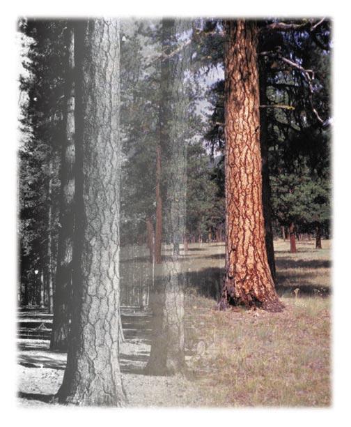
7 The Metolius River in central Oregon has clear, cold water flowing from springs that help create excellent habitat for Bull trout. summary of known distributions and the prediction of distributions and status for select species throughout the entire assessment area and was supported by information collected through more than 140 biologists working throughout the region. Aquatic habitat fragmentation (impassable obstructions including dams, temperature increases, and water diversion) and simplification (channelization, removal of woody debris, channel bed sedimentation, removal of riparian vegetation, and water flow regulation) have resulted in a loss of diversity within and among native fish populations. The composition, distribution, and status of fishes within the Basin is very different than it was historically. Some forms are extinct and many others, especially anadromous fish, are extirpated from large portions of their historical range. Although several of the key salmonids remain distributed through much of their historical ranges (notably the cutthroat trouts and interior redband trout), declines in abundance, the loss of important life histories, local extinctions, and fragmentation and isolation of high-quality habitats are apparent (maps 15 and 16). Wild chinook salmon and steelhead trout are approaching extirpation in a major part of the remaining distribution. With the exception of the Central Idaho Mountains, Snake Headwaters, and perhaps the Northern Cascades, most of the important areas for the key salmonids exist as patches of scattered watersheds. Many of these important watersheds are associated with high-elevation, steep, and more erosive landscapes. These may be more extreme or variable environments contributing to higher variability in the associated populations 107
8 Map 15 Historic key salmonid presence. 108
9 Map 16 Current key salmonid presence. 109
10 Map 17 Aquatic strongholds and low road densities. 110
11 and higher sensitivity to watershed disturbances. Even with no further habitat loss the fragmentation and isolation may place remaining populations at risk. Risks could be aggravated with further development. The distribution of steelhead trout, for example, has decreased from historical range and known or predicted strongholds are few and far between. Although less is known about the rare and sensitive fish taxa than the seven key salmonids, analyses of existing distribution and reviews of available literature provide insights about common threats and appropriate management needs. Many of these taxa occur in isolated areas of the Columbia River basin, in isolated subbasins of the Great Basin, or are restricted to the upper Klamath Basin. They typically occur in subbasins with only 1 or 2 native fish species present and in very restricted areas, often occupying 1 or 2 small habitat patches within subwatersheds (averaging 8,000 hectares in size). Consequently, broad- or midscale assessments that focus on high native species diversity may not adequately describe their distributions. Some 15 previous efforts to identify special emphasis watersheds for conservation of aquatic resources and ecosystem function in the Basin were examined to address whether habitat criteria or population presence and status are better indicators for such special fish emphasis watersheds. Fish population strength was evaluated to identify the best remaining habitats within the Basin by focusing on subwatersheds with designated strong populations of seven key salmonids. This approach has the distinct advantage of recognizing the biological building blocks necessary to maintain and rehabilitate fish populations in the Basin. More than 27 percent of FS- and BLM-administered lands in the Basin contain strongholds (40 percent of Forest Service and 4 percent of BLM). These subwatersheds contain large areas of unroaded land (map 17). Implications for Ecosystem Management Although much of the native ecosystem has been altered, core areas remain for rebuilding and maintaining functional native aquatic systems. Even though they are reduced in numbers and distributions, native trouts remain some of the most widely distributed taxa within the Basin. This suggests that although serious problems exist, particularly in the larger rivers and in the low-elevation agricultural and rangelands, the situation is somewhat better in the forested lands. Conditions remain best in areas that have experienced the least human-caused disturbance. Most of the areas exhibiting high-aquatic integrity fall within forested areas, with the exception of areas inherently high in native-species richness near the southern edge of the Basin. Although much of the native ecosystem has been altered, core areas remain for rebuilding and maintaining functional native aquatic systems. The largest areas of contiguous watersheds supporting strong populations of key salmonids are associated with the major river subbasins found in the Central Idaho Mountains, the Snake Headwaters and the Northern Cascades. Important but more restricted areas are also found in the Blue Mountains, Upper Clark Fork and the Northern Glaciated Mountains. Each of the key salmonids supported some known or predicted strong populations (table 6). The core for maintaining and restoring much of the biological diversity associated with fishes still exists. Conservation and restoration of important habitats for key salmonids could provide habitat for associated species and will sustain 111
12 Table 6 Historical and occupied range and habitat status for key salmonids within the Basin Assessment area. 1 Occupied Historical range range classed Strongholds Strongholds Depressed Sensitive to Species occupied as strong in wilderness on FS/BLM on FS/BLM FS/BLM uses... percent... Bulltrout Yes Westslope cutthroat Yes Yellowstone cutthroat Yes Redband Yes Steelhead Yes Stream-type chinook 28 < Yes Ocean-type minor chinook influence important processes that influence structure and function within these systems. Restoring or maintaining the integrity of migration corridors will be challenging. Restoration and management of watersheds only on Federal lands will not be sufficient; river corridors surrounded largely by private lands are a particularly important part of fish habitat networks. Connections and habitat provided by larger river systems are critical to maintenance of anadromous populations. Rehabilitation of depressed populations cannot rely on habitat improvement alone but requires a concerted effort to address causes of mortality in all life stages. These include freshwater spawning and rearing, juvenile migration, ocean survival, and adult migration. The introduction of non-native species and hatchery-propagated native species has influenced aquatic community composition. Containing non-natives will provide benefits that go beyond system integrity. Protection and maintenance of system integrity and functioning will require innovative approaches. Simple solutions such as setting aside small, scattered watersheds probably will not be adequate for the persistence of even current distributions and diversity. If maintenance or restoration of the integrity of aquatic ecosystems is an important goal, dramatic and decisive action is required to stop further alterations and restore areas that are degraded. If maintenance or restoration of the integrity of aquatic ecosystems is an important goal, dramatic and decisive action is required to stop further alterations and restore areas that are degraded. 112
13 While watershed protection is an effective management approach, evidence suggests that system integrity can be maintained in some intensively managed areas. It is unclear, however, whether intensively managed areas with high integrity are anomalies, regions where the effects on streams lag behind the changes on land, or are areas where intensive management and fish can coexist. Additional research will help to design management strategies to accomplish fish and habitat goals. The collective knowledge of status, distribution, and habitats for fishes is incomplete. Existing knowledge reflects the historical focus of fish management and research agencies on production and yield, recreational fishing opportunity, and high-profile species rather than on biotic integrity or species conservation. Sampling methodologies are poorly developed, inventories are incomplete, and reference standards are virtually non-existent. The development of consistent, reliable, large-scale species inventories will be critical for long-term management and evaluation of aquatic ecosystems. Field experiments can be developed to provide information on the spatial dimensions (that is, width, length, depth, space and continuity) of riparian buffer zones necessary to achieve single and multiple ecological and/or social objectives as well as how well they continue to function through time. Three types of studies can contribute to the evaluation of hydrologic and geomorphic disturbance effects. First, field surveys are needed to assess the effect of historical events such as fires and large floods. Second, intensive, opportunistic surveys could be undertaken during and following these rare events. Third, the resilience of riparian and aquatic ecosystems to changes in the magnitude and frequency of extreme events could be tested using human-caused events (such as regulating levels of dams, reservoirs, and irrigation withdrawal). 113
14 114
Stream Habitat Features. Executive Summary
 EXECUTIVE SUMMARY: BROAD-SCALE ASSESSMENT OF AQUATIC SPECIES AND HABITATS The Broad-Scale Assessment of Aquatic Species and Habitats addresses the aquatic resources within the Interior Columbia Basin Ecosystem
Scientific Literature Review of Forest Management Effects on Riparian Functions for Anadromous Salmonids
 Scientific Literature Review of Forest Management Effects on Riparian Functions for Anadromous Salmonids Presentation to: The California State Board of Forestry and Fire Protection Prepared by: Mike Liquori
The Science Behind Forest Riparian Protection in the Pacific Northwest States By George Ice, Summer 2004
 The Science Behind Forest Riparian Protection in the Pacific Northwest States By George Ice, Summer 2004 Riparian buffers, streamside management zones, and similar measures are essential parts of forest
Chehalis Basin Strategy Programmatic SEPA Draft EIS
 Chehalis Basin Strategy Programmatic SEPA Draft EIS History of Flooding I-5 closed in 1990, 1996, 2007, 2009 Five largest flood events occurred since 1986 2 History of Habitat Degradation Harvest has been
Tim Hayden, Yurok Tribe Natural Resources Division Mat Millenbach, Western Rivers Conservancy Sarah Beesley, Yurok Tribal Fisheries Program
 BLUE CREEK FOREST SANCTUARY: RESTORING OLD GROWTH FOREST ECOSYSTEM FUNCTION, PROTECTING SALMON, WILDLIFE, AND TRADITIONAL- LIFE WAYS AND CULTURE IN THE FACE OF CLIMATE CHANGE Tim Hayden, Yurok Tribe Natural
Western Strait Drainages. Watershed Summaries DRAINAGES EST WRIA 19 EST
 Page 31 WESTERN STRAIT DRAINAGES EST WRIA 19 WEST EST Snow, Bullman, Jansen & Olsen Creeks Sekiu River Hoko & Little Hoko Rivers Clallam River & Estuary Pysht River & Estuary Green Creek Jim & Joe Creeks
CNL(10)51. NASCO Guidelines for the Protection, Restoration and Enhancement of Atlantic salmon Habitat
51. NASCO Guidelines for the Protection, Restoration and Enhancement of Atlantic salmon Habitat") CNL(10)51 NASCO Guidelines for the Protection, Restoration and Enhancement of Atlantic salmon Habitat 1. Introduction Salmon habitat in freshwater has been greatly affected by various activities, both
CNL(10)51 NASCO Guidelines for the Protection, Restoration and Enhancement of Atlantic salmon Habitat 1. Introduction Salmon habitat in freshwater has been greatly affected by various activities, both
3 Baseline and Existing Conditions
 1 2 3 4 5 6 7 8 9 10 11 12 13 14 3 Baseline and Existing Conditions The effective date of the VSP legislation is July 22, 2011. This is also the date chosen by the legislature as the applicable baseline
Wildlife Conservation Strategy
 Wildlife Conservation Strategy Boise National Forest What is the Wildlife Conservation Strategy? The Boise National Forest is developing a Wildlife Conservation Strategy (WCS) in accordance with its Land
Inventory of Management Programs
 Appendix C Salmon Recovery Plan Inventory of s Table 1 Inventory of management programs, sponsors or agencies, area affected by the programs, goal of the programs, and a determination whether the program
Mike Liquori Principal, Sound Watershed.
 Mike Liquori Principal, Sound Watershed www.soundwatershed.com ~101 M acres 16.6 M ac of public and privately owned commercial timberland 9.3 M ac public ownerships 7.3 M ac privatelyowned timberland
Request for Proposal Scope Development Guide. Asotin County Geomorphic Assessment. and. Conceptual Restoration Plan
 Request for Proposal Scope Development Guide Asotin County Geomorphic Assessment and Conceptual Restoration Plan Asotin County Conservation District December 3, 2015 1 1.0 INTRODUCTION The Asotin County
Understanding and Restoring Natural Floodplain Function. Gary James CTUIR Fisheries Program Manager
 Understanding and Restoring Natural Floodplain Function Gary James Fisheries Program Manager Future of Our Salmon Technical Workshop on Healthy Floodplains Spokane, WA - August 16-18, 2016 Presentation
Funding Guidelines State Fiscal Year 2016
 State Fiscal Year 2016 Water Quality Financial Assistance Centennial Clean Water Program Clean Water Act Section 319 Program Stormwater Financial Assistance Program Washington State Water Pollution Control
HYDROLOGY, WATER USE, AND INFRASTRUCTURE
 HYDROLOGY, WATER USE, AND INFRASTRUCTURE Water resources in the Blue Mountains are valued for fisheries and other aquatic biota, recreation, municipal and residential use, vegetation, agriculture, and
SHORELINE INVENTORY AND RESTORATION PLANNING
 CHAPTER 3 SHORELINE INVENTORY AND RESTORATION PLANNING A. PURPOSE OF THE SHORELINE INVENTORY AND CHARACTERIZATION A first step in the comprehensive Master Program update process is development of a shoreline
GRAYS HARBOR ESTUARY MANAGEMENT UNIT GRAYS HARBOR ESTUARY
 GRAYS HARBOR ESTUARY MANAGEMENT UNIT GRAYS HARBOR ESTUARY Description: The Grays Harbor Estuary is a bar-built estuary that was formed by the combined processes of sedimentation and erosion caused by both
DECISION RECORD for the Rattlesnake Negotiated Timber Sale (Reference:
 DECISION RECORD for the Rattlesnake Negotiated Timber Sale (Reference: Bly Mtn. / Swan Lake / Rattlesnake Reservoir Forest Health and Woodland Treatments Environmental Assessment #OR014-99-6) Introduction
How Much Habitat Is Enough? How Much Disturbance is Too Much?
 How Much Habitat Is Enough? How Much Disturbance is Too Much? Jocelyn Sherwood Canadian Wildlife Service - Ontario January 27 th, 2017 Page 2 April 19, 2017 Page 3 April 19, 2017 Grasslands Forest Wetlands
How Much Habitat is Enough?
 How Much Habitat is Enough? Canadian Wildlife Service 2017 Third Edition Page 2 April 19, 2017 Grasslands Forest Wetlands Riparian & Watershed Page 3 April 19, 2017 Significant impairment in stream At
JUVENILE SALMON MIGRATION SECTION 5. blank page
 blank page FISH AND WILDLIFE PROGRAM 5-16 September 13, 1995 SECTION 5 JUVENILE SALMON MIGRATION temperature improvement measures contained in this program will have a substantial impact on the operations
Prioritizing restoration activities for salmonid habitat within a watershed
 Prioritizing restoration activities for salmonid habitat within a watershed Author: Lisa Lackey Co-author: Laurel Marcus Abstract Maacama Creek, a tributary of the Russian River has 45 miles of tributary
Assisted Migration Workshop - Case Study
 Assisted Migration Workshop - Case Study Species/populations involved: Banbury Springs Lanx Case study location: Thousand Springs, Idaho Actual or hypothetical: Actual Climate change projections for species:
Logo Department Name Agency Organization Organization Address Information Petersburg Ranger District P.O. Box 1328 Agriculture
 Logo Department Name Agency Organization Organization Address Information United States Forest Tongass National Forest Petersburg Ranger District Department of Service Alaska Region P.O. Box 1328 Agriculture
Watershed Health and Water Management in the Porcupine Hills
 Watershed Health and Water Management in the Porcupine Hills In Alberta, our quality of life is tied to healthy and sustainable water supplies for the environment, for our communities, and for our economic
Atlantic Salmon ESA Listing Workshop
 Atlantic Salmon ESA Listing Workshop MARCH 26, 2010 Declining numbers of adults ESA Listing Overview When and why was the listing? 2000 Downeast rivers listing Other rivers added in June 2009 Prompted
Science-Policy Workshop: Predation Portland, Oregon 9 August Robert J Naiman University of Washington and ISAB
 Science-Policy Workshop: Predation Portland, Oregon 9 August 2012 Robert J Naiman University of Washington and ISAB Review Objective & Approach Provide a fundamental understanding of aquatic food webs
White Paper No Global Climate Change and its Effects on the Columbia River Basin
 White Paper No. 3 1 Global Climate Change and its Effects on the Columbia River Basin 1 Introduction The purpose of this white paper is to describe possible impacts of climate change on the anadromous
3.28 RESEARCH NATURAL AREAS
 3.28 RESEARCH NATURAL AREAS Introduction Research Natural Areas (RNAs) are areas designated, in perpetuity, for non-manipulative research and educational purposes, as well as to help maintain ecological
Hydrobiological & Landscape Sciences
 Frissell & Raven Hydrobiological & Landscape Sciences Polson, MT USA Email: leakinmywaders@yahoo.com Web: www.researchgate.net/profile/christopher_frissell 27January 2017 MEMO FROM: Christopher A. Frissell,
3. Identification of problem or opportunity to be addressed
 1. Project Title Clearwater Creek Instream Habitat Restoration 2. Project Manager Adam Haspiel Mt. St. Helens National Volcanic Monument 42218 NE Yale Bridge Road Amboy, WA 98604 360-449-7833 360-449-7801
The F.O.R.C.E. The Future Of Redwood Creek Environment
 The F.O.R.C.E. The Future Of Redwood Creek Environment Robert Andersen Katelyn Csatari Achyuth Madabhushi Julie Swanson Overview Mission Statement Watershed Characterization Land and Water Use History
Post-Fire BAER Assessment Burned Area Emergency Response (BAER)
") November 2017 Post-Fire BAER Assessment Burned Area Emergency Response (BAER) Information Brief Diamond Creek Fire Values at Risk Matrix and Treatments CentralWashingtonFireRecovery.info EMERGENCY DETERMINATION
November 2017 Post-Fire BAER Assessment Burned Area Emergency Response (BAER) Information Brief Diamond Creek Fire Values at Risk Matrix and Treatments CentralWashingtonFireRecovery.info EMERGENCY DETERMINATION
PRE-PROPOSAL FORM Lewis River Aquatic Fund 2011
 PRE-PROPOSAL FORM Lewis River Aquatic Fund 2011 Form Intent: To provide a venue for an applicant to clearly indicate the technical basis and support for proposed project. Specifically the project s consistency
Central Strait Drainages DRAINAGES AST WRIA 19 AST
 Page 41 CENTRAL STRAIT DRAINAGES AST WRIA 19 EAST AST Deep Creek East Twin River E. Fork East Twin & Sadie Creek West Twin River Lake Crescent / Lyre River System Murdock Creek Field, Whiskey & Colville
Pacheco Reservoir Expansion
 California Water Commission Pacheco Reservoir Expansion Unique Opportunity for Fisheries Recovery, Flood Risk Reduction and Emergency Water Supply December 13, 2017 1 of 33 Project Partners Pacheco Pass
Projects must fall under one of the nine categories listed in Table 1.
 UNITED STATES DEPARTMENT OF COMMERCE National Oceanic and Atmospheric Administration NATIONAL MARINE FISHERIES SERVICE West Coast Region Snake Basin Office 800 Park Boulevard, Plaza IV, Suite 220 Boise,
Hydroecological tool: enhancements and results. enhancements and results. Marci Meixler. Project partners: Sponsored by:
 Hydroecological tool: Marci Meixler Sponsored by: Project partners: Motivation Great Lakes Charter Annex establish uniform, regional protections for Great Lakes waters ensure that authority over the Lake
RE: Fishery evaluation for South, Old Cow Creek Hydroelectric Facilities
 April 29th, 2008 Richard Ely, Davis Hydro 27264 Meadowbrook Drive Davis CA 95618 RE: Fishery evaluation for South, Old Cow Creek Hydroelectric Facilities On January 29 th, 2008 Cramer biologists Joseph
Stream Crossing Reconstruction on the Bog Dam Loop Road (FR15) Scoping Notice. Androscoggin Ranger District
 Scoping Notice. Androscoggin Ranger District") United States Department of Agriculture Forest Service White Mountain National Forest Stream Crossing Reconstruction on the Bog Dam Loop Road (FR15) Scoping Notice Androscoggin Ranger District Androscoggin
United States Department of Agriculture Forest Service White Mountain National Forest Stream Crossing Reconstruction on the Bog Dam Loop Road (FR15) Scoping Notice Androscoggin Ranger District Androscoggin
Kachess River Action #1: Upper Kachess River Habitat and Passage Projects
 Kachess River Action #1: Upper Kachess River Habitat and Passage Projects Action Type: Research / Recovery Life stage(s) affected: Juvenile rearing, pre/post spawning migrations Threat addressed: Altered
Restoration of Riparian Forests and Riparian Ecosystem Processes and Implications for Salmon Restoration. Katie Ross-Smith Jennifer Hammond
 Restoration of Riparian Forests and Riparian Ecosystem Processes and Implications for Salmon Restoration Katie Ross-Smith Jennifer Hammond Outline > Background California riparian communities Riparian
ECOSYSTEM HEALTH AND SALMON RESTORATION: A BROADER PERSPECTIVE
 Orr 1 ECOSYSTEM HEALTH AND SALMON RESTORATION: A BROADER PERSPECTIVE BRUCE K. ORR Stillwater Sciences, Berkeley, California, USA ABSTRACT An understanding of healthy, naturally functioning riverine and
Appendix 2. Summary of the U.S. Fish and Wildlife Service 2010 Warranted but Precluded Determination
 Appendix 2. Summary of the U.S. Fish and Wildlife Service 2010 Warranted but Precluded Determination This appendix contains a summary of the U.S. Fish and Wildlife Service (USFWS) 12-month findings for
18 Little White Salmon Subbasin
 18 Little White Salmon Subbasin Figure 18-1. Location of the Little White Salmon River Subbasin within the Lower Columbia River Basin. 18.1 Basin Overview The Little White Salmon Subbasin encompasses approximately
Meacham Creek Fish Habitat Enhancement: Application of the CTUIR River Vision
 Meacham Creek Fish Habitat Enhancement: Application of the CTUIR River Vision Future of Our Salmon A Vision of Restoration in the Columbia River Basin June 1, 2011 James Webster Confederated Tribes of
Session C7- Building on the $10 million/year H TAP program for culvert mitigation on national forest system lands
 University of Massachusetts - Amherst ScholarWorks@UMass Amherst International Conference on Engineering and Ecohydrology for Fish Passage International Conference on Engineering and Ecohydrology for Fish
Beverly. Produced in This report and associated map provide information about important sites for biodiversity conservation in your area.
 CONSERVING THE BIODIVERSITY OF MASSACHUSETTS IN A CHANGING WORLD Beverly Produced in 2012 This report and associated map provide information about important sites for biodiversity conservation in your
Yakima Tributary Access & Habitat Program Summary of Accomplishments Diversion 14 Fish Passage and Screening, 2003 Ahtanum Creek
 Yakima Tributary Access & Habitat Program Summary of Accomplishments Diversion 14 Fish Passage and Screening, 2003 Ahtanum Creek This early action project involved removing a fish passage barrier, screening
Resource Management Plans for Western Oregon
 Resource Management Plans for Western Oregon Bureau of Land Management Includes: Background, Timeline and NEPA Planning Steps, and the full text of the. The proposed action is to revise the current resource
B.C. Protected Areas Research Forum. Taking Nature s Pulse The Status of Biodiversity in British Columbia Putting Science into Action
 B.C. Protected Areas Research Forum Taking Nature s Pulse The Status of Biodiversity in British Columbia Putting Science into Action December 2, 2008 Who is Biodiversity BC? Ducks Unlimited Canada Environment
Ongoing and Completed Studies
 Attachment 2 Ongoing and Completed Studies 2014 Monitoring and Analysis Plan November 2013 Attachment 2 Ongoing and Completed Studies 1 Introduction In 2013, the small interdisciplinary study groups for
State of the Waters ~ Overview
 Chapter 1 Page 2 Background & Purpose State of the Waters ~ The waters of Clallam County are varied, in some cases provide abundant resources for fish, wildlife and humans. In others, their quality has
A modelling framework to predict relative effects of forest management strategies on coastal stream channel morphology and fish habitat
 A modelling framework to predict relative effects of forest management strategies on coastal stream channel morphology and fish habitat by FRANK STEFAN PETER HEINZELMANN A THESIS SUBMITTED IN PARTIAL FULFILLMENT
Linear Manmade Structures, Hydroscape Fragmentation, And Ecological Consequences
 Linear Manmade Structures, Hydroscape Fragmentation, And Ecological Consequences Quan Dong US Army Corps of Engineers Hydroscape (Dong 2009) Surface water dominates: patches and flux Spatially heterogeneity:
What is an ecosystem?
 What is an ecosystem? An ecosystem is generally defined as a community of organisms living in a particular environment and the physical elements in that environment with which they interact. (http://www.enviroliteracy.org/category.php/3.html)
No Net Loss of Ecological Function Guiding Questions and Summary Examples
 No Net Loss of Ecological Function Guiding Questions and Summary Examples Prepared by Jim Kramer, Carol MacIlroy, and Margaret Clancy 1 October 5, 2010 Introduction and Purpose Almost 40 years ago the
LAWSUIT TO PROTECT SALMON FROM PESTICIDES UNDER THE ENDANGERED SPECIES ACT
 LAWSUIT TO PROTECT SALMON FROM PESTICIDES UNDER THE ENDANGERED SPECIES ACT Background Information on Pesticides and Salmon Pesticides have profound effects on Northwest salmon and may be a serious factor
Steward and Associates 120 Avenue A, Suite D Snohomish, Washington Tel (360) / Fax (360)
 / Fax (360)") 1 INTRODUCTION This document provides an analysis of the Draft Washington State Forest Practices Habitat Conservation Plan (FPHCP) (Washington State Department of Natural Resources [WDNR] 2004) with the
1 INTRODUCTION This document provides an analysis of the Draft Washington State Forest Practices Habitat Conservation Plan (FPHCP) (Washington State Department of Natural Resources [WDNR] 2004) with the
Headwater Drainage Features
 Headwater Drainage Features Their Natural Functions and an Interim Guideline for their Evaluation, Classification and Management Susan Jorgenson (CVC) & Laura Del Giudice (TRCA) Urban development within
Wilderness, Wildlife, and Ecological Values of the Hyalite-Porcupine-Buffalo Horn Wilderness Study Area Executive Summary
 Wilderness, Wildlife, and Ecological Values of the Hyalite-Porcupine-Buffalo Horn Wilderness Study Area Executive Summary This 155-page report is a review of existing data and literature that were available
Prioritization Framework For Management Strategies in the Entiat Subbasin Plan
 Prioritization Framework For Management Strategies in the Entiat Subbasin Plan November, 2004 Co-Planners: Chelan County Yakama Nation Prepared by Introduction The purpose of this report is to provide
Kelly Burnett 1 Gordon Reeves 1 Dan Miller 2. Sharon Clarke 3 Kelly Christiansen 1 Ken Vance-Borland 3
 Kelly Burnett 1 Gordon Reeves 1 Dan Miller 2 Sharon Clarke 3 Kelly Christiansen 1 Ken Vance-Borland 3 PNW Research Station 1, Earth Systems Institute 2 & Oregon State University 3 Landscape Conditions
Pacific Northwest Region, Forest Service Basin-scale Restoration Prioritization Process
 Pacific Northwest Region, Forest Service Basin-scale Restoration Prioritization Process Pacific Northwest Region U.S.D.A. Forest Service Dave Heller, Regional Fish Program Leader Bruce McCammon, Regional
Assessing Habitat in Watersheds. Sabrina Drill UC Cooperative Extension Los Angeles and Ventura
 Assessing Habitat in Watersheds Sabrina Drill UC Cooperative Extension Los Angeles and Ventura sldrill@ucdavis.edu 323-260 260-3404 What is Habitat? The environment in which a plant and animal lives, and
Effects of habitat degradation on salmon and trout populations: Logging practices as a case study in the complexity of salmonid life cycles
 Effects of habitat degradation on salmon and trout populations: Logging practices as a case study in the complexity of salmonid life cycles Why worry about habitat? Factors responsible for risk in 214
Summary of the 1997 Fish Habitat Risk Assessment Panel
 United States Department of Agriculture Forest Service Tongass National Forest Forest Plan Interdisciplinary Team 8465 Old Dairy Road Juneau, Alaska 99801 (907) 586-8700 Reply To: RS-G-b Date: May 7, 1997
State Forests Salmon Protection Policy
 General File # 3-2-1-310 State Forests Salmon Protection Policy January 25, 2002 History, Purpose and Need In June 2000, the National Marine Fisheries Service (NMFS) adopted rules under Section 4(d) of
Support legislation that will protect the quantity of water in Lake Erie
 Specific Regional Priorities Each of Pennsylvania s major drainage basins has an array of individual characteristics that distinguish it from other regions of the state. These include diverse geographic
Endangered Species Act: Federal Nexus and Consultations on Floodplain Mapping. Skagit River flood1995, Allen Kam, NOAA
 Endangered Species Act: Federal Nexus and Consultations on Floodplain Mapping Skagit River flood1995, Allen Kam, NOAA Presentation Overview Endangered Species Act; Purpose and Requirements for Consultation
Queen Charlotte Islands Project
 Queen Charlotte Islands Project 1981 Introduction The Queen Charlotte Islands Fish-Forestry Interaction Program was an interdisciplinary study assessing the interactions between timber harvesting operations
Public Notice. Public Notice No. Date: April 8, 2016 CENAP-PL-E Comment Period Closes: May 9, 2016
 Public Notice Public Notice No. Date: April 8, 2016 CENAP-PL-E-16-02 Comment Period Closes: May 9, 2016 USACE Philadelphia District: http://www.nap.usace.army.mil COBBS CREEK FISH PASSAGE PROJECT SECTION
Decision Notice and Finding of No Significant Impact
 Decision Notice and Finding of No Significant Impact Indigo and Middle Fork Willamette Enhancement Project USDA Forest Service Middle Fork Ranger District Willamette National Forest Lane County, Oregon
Meacham Creek Restoration Project
 Meacham Creek Restoration Project Meacham Creek Restoration Project Umatilla National Forest Walla Walla Ranger District Michael Rassbach, District Ranger Public Scoping Document Proposal Summary The Walla
Fish Passage EXEMPTION Application
 OREGON DEPARTMENT OF FISH AND WILDLIFE Fish Passage EXEMPTION Application Use this form if a waiver has already been granted for the artificial obstruction for which an Exemption is being requested, fish
LIST OF TECHNICAL APPENDICES
 Idaho Power Company List of Technical Appendices LIST OF TECHNICAL APPENDICES Sediment and Geomorphology E.1-1 Sediment Transport, Supply, and Stability in the Hells Canyon Reach of the Snake River This
Coho Recovery Planning at the Population Scale
 Coho Recovery Planning at the Population Scale Water Quality Summit February 28, 2018 The Coho Business Plan Discuss efforts to plan for and inform recovery, highlighting the value of coordination. Why
Mohawk River Basin Research Initiative
 Mohawk River Basin Research Initiative 2014-2016 In 2009 the New York Ocean and Great Lakes Ecosystem Council issued a report entitled Our Waters, Our Communities, Our Futures which recommended an ecosystem-based
Hood River Watershed Group to sustain and improve the Hood River watershed through education, cooperation, and stewardship
 You are living in a watershed A watershed is the land area that drains to a particular lake, stream, or river. The Hood River watershed covers 339 square miles between Mt. Hood and the Columbia River.
2018 Snake River Salmon Recovery Board Project Application
 2018 Snake River Salmon Recovery Board Project Application Pre-Application Section (This section must also must be included as part of the Draft and Final Applications if you don t submit a pre-application).
Criteria for Identifying and Prioritizing Habitat Protection and Restoration Projects on the Lower Columbia River and Estuary*
 Criteria for Identifying and Prioritizing Habitat Protection and Restoration Projects on the Lower Columbia River and Estuary* Ecosystem Criteria 1) Habitat Connectivity (0-10 points) This criterion recognizes
Rogue Basin Ecological Integrity Assessment and Climate Change Management Interactions
 Rogue Basin Ecological Integrity Assessment and Climate Change Management Interactions Jimmy Kagan OSU PSU UO Ecological Integrity Measures (by area) Land management status Landscape features Habitat characteristics
Central Washington 2012 Wildfires Burned Area Emergency Response (BAER) Information Brief October 19, 2012 BAER Information: (208)
 Information Brief October 19, 2012 BAER Information: (208)") Okanogan-Wenatchee National Forest Central Washington 2012 Wildfires Burned Area Emergency Response (BAER) Information Brief October 19, 2012 BAER Information: (208) 398-3348 Fire Background WENATCHEE
Okanogan-Wenatchee National Forest Central Washington 2012 Wildfires Burned Area Emergency Response (BAER) Information Brief October 19, 2012 BAER Information: (208) 398-3348 Fire Background WENATCHEE
Managing Water Resources in Grand Teton National Park
 Managing Water Resources in Grand Teton National Park Susan E. O'Ney Resource Management Biologist Greater Yellowstone Network 1 Park Service Mission: The National Park Service Organic Act of 1916, defined
Hiram Li (USGS Oregon Cooperative Fish and Wildlife Research Unit),
,") Coldwater fishes and thermal refuges in hot water Christian Torgersen US Geological Survey, Forest and Rangeland Ecosystem Science Center, Cascadia Field Station, College of Forest Resources, University
Coldwater fishes and thermal refuges in hot water Christian Torgersen US Geological Survey, Forest and Rangeland Ecosystem Science Center, Cascadia Field Station, College of Forest Resources, University
PROJECT SCREENING MATRIX: A User s Guide
 Version 2.0 Page 1 of 7 November 9, 2010 PROJECT SCREENING MATRIX: A User s Guide BACKGROUND The Project Screening Matrix (Screening Matrix) is one of several tools that comprise the River Restoration
Influence of Land Use, and its Change, on Streams and Rivers
 Influence of Land Use, and its Change, on Streams and Rivers Ways in which land use alteration modifies streams. (from JD Allan 2004, Annu. Rev. Ecol., Evol. and Syst.) Dominant types of land use change:
An Evaluation of CRITFC-Coordinated Habitat Restoration Projects and Limiting Factors to Salmon and Steelhead in the Columbia Basin
 An Evaluation of CRITFC-Coordinated Habitat Restoration Projects and Limiting Factors to Salmon and Steelhead in the Columbia Basin David Graves, CRITFC December 2009 Introduction Several salmon and steelhead
Influence of Land Use, and its Change, on Streams and Rivers
 Influence of Land Use, and its Change, on Streams and Rivers Ways in which land use alteration modifies streams. (from JD Allan 2004, Annu. Rev. Ecol., Evol. and Syst.) Dominant types of land use change:
Project sponsors provided a brief presentation on their project(s), followed by comments from the Committee.
, followed by comments from the Committee.") WRIA 14 Salmon Habitat Recovery Committee Meeting April 17, 2014 Summary notes Project sponsors provided a brief presentation on their project(s), followed by comments from the Committee. Allyn Shoreline
WRIA 14 Salmon Habitat Recovery Committee Meeting April 17, 2014 Summary notes Project sponsors provided a brief presentation on their project(s), followed by comments from the Committee. Allyn Shoreline
California Rapid Assessment Method for Wetlands (CRAM) Buffer and Landscape Context Attribute
 Buffer and Landscape Context Attribute") California Rapid Assessment Method for Wetlands (CRAM) Buffer and Landscape Context Attribute Buffer and Landscape Context Attribute Presence and/or continuity of wetlands and riparian areas adjacent to
California Rapid Assessment Method for Wetlands (CRAM) Buffer and Landscape Context Attribute Buffer and Landscape Context Attribute Presence and/or continuity of wetlands and riparian areas adjacent to
1/16/2016. California Rapid Assessment Method for Wetlands (CRAM) Buffer and Landscape Context Attribute. Buffer and Landscape Context Attribute
 Buffer and Landscape Context Attribute. Buffer and Landscape Context Attribute") California Rapid Assessment Method for Wetlands (CRAM) Buffer and Landscape Context Attribute Buffer and Landscape Context Attribute Presence and/or continuity of wetlands and riparian areas adjacent to
California Rapid Assessment Method for Wetlands (CRAM) Buffer and Landscape Context Attribute Buffer and Landscape Context Attribute Presence and/or continuity of wetlands and riparian areas adjacent to
Flathead National Forest Assessment
 The following terms are defined in the 2012 Planning Rule ( 219.19 Definitions): Assessment. For the purposes of this subpart, an assessment is the identification and evaluation of existing information
7.0 WATER-BASED CONTROL MEASURES
 7.0 WATER-BASED CONTROL MEASURES 7.1 IDENTIFICATION AND DESCRIPTION OF CONTROL MEASURES Table 7-1 lists the water-based options being considered for implementation in the initial screening stage. Descriptions
Case Studies III: Skokomish River Ecosystem Restoration Washington State
 University of Massachusetts - Amherst ScholarWorks@UMass Amherst International Conference on Engineering and Ecohydrology for Fish Passage International Conference on Engineering and Ecohydrology for Fish
TAC CHARRETTE WORKBOOK Ecosystem Management and Sustainable Forestry Practices
 For Discussion Purposes TAC CHARRETTE WORKBOOK Ecosystem Management and Sustainable Forestry Practices NEW JERSEY HIGHLANDS COUNCIL March 28, 2006 1 Overview of RMP Goals and Structure NEW JERSEY HIGHLANDS
Links between riparian forest ecosystems and aquatic communities
 Links between riparian forest ecosystems and aquatic communities By Kate Knox INTRODUCTION The composition of riparian floral and faunal communities is strongly dependent upon the physical and chemical
Biological Opinion. Morse Brothers Habitat Restoration Project. Endangered Species Act - Section 7 Consultation
 Endangered Species Act - Section 7 Consultation Biological Opinion Morse Brothers Habitat Restoration Project Agency: Army Corps of Engineers, Portland District Consultation Conducted By: National Marine
DECISION MEMO. Crow Creek Hardened Crossing
 Page 1 of 5 DECISION MEMO USDA Forest Service Madison Ranger District Madison County T12S, R4W in Section 35 Background A perennial cattle crossing on Crow Creek in in the Gravelly Landscape in the Centennial
Chapter Four: Overview. Introduction to Environmental Geology, 5e. Case History: Endangered Trout. Ecology and Geology Linkage
 Chapter Four: Overview Introduction to Environmental Geology, 5e Chapter 4 Ecology and Geology Jennifer Barson Spokane Falls Community College Linkages between geology with ecology and relationships with