Flood design recipes vs. reality: Can predictions for ungauged basins be trusted? A perspective from Greece
|
|
|
- Phillip Ward
- 6 years ago
- Views:
Transcription
1 International conference: Advanced methods for flood estimation in a variable and changing environment University of Thessaly, Volos, October 2012 Flood design recipes vs. reality: Can predictions for ungauged basins be trusted? A perspective from Greece Andreas Efstratiadis 1, Antonis Koussis 2, Demetris Koutsoyiannis 1, Nikos Mamassis 1, and Spyros Lykoudis 2 (1) Department of Water Resources & Environmental Engineering, National Technical University of Athens (2) Institute of Environmental Research & Sustainable Development, National Observatory of Athens
2 Motivation: Floods, flood engineering and flood science Disasters caused by large floods increase worldwide as result of the changing environment (urbanization, deforestation) despite the development of better infrastructures, better forecasting systems and better management plans. Engineering practice vs. advances in hydrological sciences Many flood protection structures are still designed using simplistic rules-of-thumb and semi-empirical approaches; Most of engineering recipes were developed many decades ago but they have never been validated and adapted to local conditions; Although typical engineering knowledge is far behind scientific advances, too little attention is spent to mitigate this gap; Too little research funding is provided for practical issues in flood hydrology most of proposals are rejected as trivial. See relevant lecture by Koutsoyiannis (2012) titled Reconciling hydrology with engineering
3 Further motivation: The Greek case Greek basins exhibit significant peculiarities with regard to their hydroclimatic regime and geomorphology Semi-arid climate (Eastern Greece and Aegean islands) yet characterized by intense storms that generate flash floods; Highly fragmented geometry, formulation of numerous small and medium scale basins (typical areas 50 to 250 km 2 ), steep terrain; Domination of highly-permeable formations (~40% carbonate), surface and groundwater interactions, ephemeral flows. Greece lacks reliable flood data With few exceptions, Greek basins are ungauged; Even in gauged rivers, finely-resolved hydrometric data is of questionable accuracy (rating curves?) and hardly accessible; Greece lacks guidelines and specifications for flood studies; it also lacks know-how to respond to the advanced requirements of the 2007/60/EU Directive.
4 Flood design recipes vs. reality: The rational method (q = cia) The rational equation, proposed in 1850 by the Irish engineer T. J. Mulvany, is still the typical design tool in small ungauged basins and for urban drainage studies. Its implementation is based on the following recipe : Assign a statistical model to the rainfall maxima and implement idf analysis (preferably through the Gumbel model, which has an attractive analytical expression, easily handled in a spreadsheet); Compute the time of concentration of the basin from a literature formula (doesn't mater which) and set it equal to rainfall duration; Compute the corresponding critical rainfall intensity and reduce this value, using an areal reduction formula (never mind if this was developed for storms that are generated by typhoons); Select a runoff coefficient from a table with typical values (hoping to find a soil class that resembles your basin characteristics);
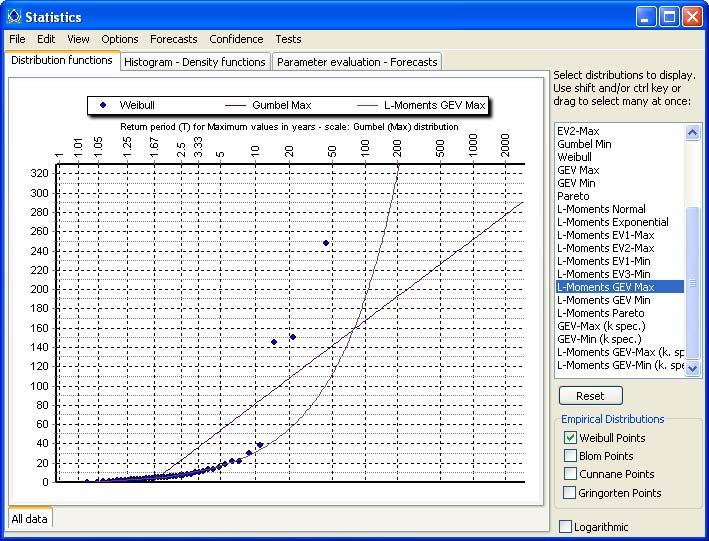
5 The rational method recipe vs. reality: (a) Selecting rational statistical models For return periods > 50 years, the widely-used Gumbel (EV1) distribution results to significantly lower values of the design rainfall than other extreme models, e.g. EV II. Statistical investigations using large samples worldwide prove that heavily-tailed distributions are in better agreement with the observed rainfall extremes (Papalexiou et al., 2012). Rescaled rainfall depth Return period, years Empirical EV2/Least squares EV2/Moments EV2/L-moments EV2/Max likelihood EV1/L-moments EV II models Gumbel model Gumbel reduced variate EV2 (more known as GEV) and EV1 (Gumbel) distributions fitted by several methods and comparison with the empirical distribution for a record of all 169 annual maximum rescaled daily rainfall series ( station years; chart reproduced by Koutsoyiannis, 2004)
6 The rational method recipe vs. reality: (b) The time of concentration paradox The time of concentration is key issue in flood modeling. The concept is unambiguous, since there exist different definitions for t c (at least eight, according to McCuen, 2009). There are numerous empirical formulas and computational procedures for t c, without reference to a specific definition. Theoretical evidence and experiments indicate that t c is not a constant, but decreases with flow (Grimaldi et al., 2012). Q depends on t c and vice versa: a puzzle for engineering hydrology! Recent article by Grimaldi et al. (2012), providing new insights in the concept of t c
7 The rational method recipe vs. reality: (c) Jumping from point to areal rainfall Areal reduction factors (ARF) are typically employed, which give the ratio between the areal and the corresponding point rainfall, for a specific basin area, duration and return period. This relationship has been also found to vary with return km period, weather type and 2 topography (e.g., Veneziano km 2 10 km 2 and Langousis, 2005). 30 km 2 In large basins, where the spatial variability of rainfall is significant at all time scales, the ARF approach overestimates the areal rainfall. Συντελεστής επιφανειακής αναγωγής, φ Areal reduction factor km km km km 2 1 h 2 h km 2 6 h km ιάρκεια, d (min) 12 h 24 h 2 d Nomograph derived from tabular values of ARF by NERC (1975; Koutsoyiannis, 2011) 5 d 10 d 25 d Duration (min)
8 The rational method recipe vs. reality: (d) The runoff coefficient Just a multiplier? The term runoff coefficient is widely used in hydrology to express which percentage of rainfall is transformed to runoff, and varies substantially with the aggregation scale. In the rational method, it is used as cut-off threshold to separate the effective from the total rainfall. In reality, it incorporates all uncertainties that are related with the antecedent soil moisture conditions, the temporal distribution of rainfall, etc. In this context, similarly to the time of concentration, it is not a characteristic parameter of the basin but a variable. A consistent application of the elementary rational method is far from trivial, while a number of open research questions exist regarding all its aspects!

9 Regional formulas: suitable for all regions? Empirical regional formulas for most of design parameters were developed by employing regression analysis to field data, gathered from experimental catchments. How many and how much representative are these basins? Was the data adequate for obtaining reliable statistical conclusions? How many thousands of flood studies have been elaborated worldwide, using the Kirpich (1940) formula?
10 Back to the beginning: data (especially, flows) (because there does not exist hydrology without hydrological data) Why flood flow measurements? Because the current engineering recipes should be evaluated and validated against local hydroclimatic and geomorphological conditions, before being applied in practice; Because it may be necessary to revise or even reconstruct from scratch, at least some of the popular recipes. Ok, but measurements are costly The quality and reliability of hydrological studies depends on data; The safety and cost of the flood-protection works depends on the quality and reliability of hydrological studies; Ok, but a lot of time is required to obtain long data samples Measurements can (and should) be extended in both time and space; As new data arrive, the recipes can (and should) be updated.
11 A perspective from Greece: The research project Deucalion * Full project title: Assessment of flood flows in Greece under conditions of hydroclimatic variability: Development of physically-established conceptual-probabilistic framework and computational tools Project info Duration: March 2011 March 2014 Budget: (public funding ) Commissioner: General Secretariat of Research & Technology Partnerships: (1) ETME Peppas & Collaborators S.A.; (2) Maheras Technical Office S.A., (3) National Technical University of Athens; (4) National Observatory of Athens (*) In Ancient Greek mythology, Deucalion ( ευκαλίων) is the Biblical equivalent of Noah. Deucalion, with the aid of his father Prometheus, was saved from a major deluge caused by Zeus, by building a chest. When the waters receded after nine days, he and his wife Pyrrha, were the one surviving pair of humans (source: Wikipedia).
12 Project outline & work packages WP1: Pilot basins & monitoring network Raw meteo & flow data Topographic & geographical data WP2: Data processing Hydrometeorological time series Basin & cross-section geometry, GIS Statistical analysis of intense storms IDF curves WP3: Flood modeling tools Stochastic analysis of rainfall Generation of synthetic data Event-based design (semi-empirical relationships & regional methods) WP5: Assessment of methods Back analysis of pilot flood studies at selected basins Technical & economic comparisons Continuous approaches, coupling hydrological and hydraulic models WP4: Flood forecasting Short-term weather prediction (rainfall ensembles) Flood forecast & risk assessment WP6: Technical specifications for flood studies Design criteria and methods Public debate & consultation


 Lousios (166.")
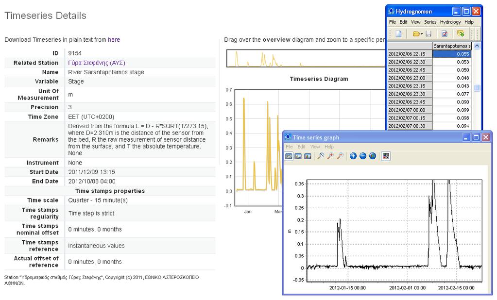
13 Pilot basins, monitoring network & data Development of 4 pilot basins, with 8 stage recording & 10 meteorological stations, and an open-source application, to visualize and provide online data ( Further data were obtained from Cyprus basins, with long and reliable records, and an experimental basin in Greece. Sarantapotamos (65.7 km 2 ) Lousios (166.3 km 2 ) Chalandri stream (5.2 km 2 ) Nedontas (52.3 km 2 )


14 Software & models Supervision & management of monitoring stations Hydrological modeling Statistical modeling Time series retrieval & processing
 Peak discharge (m 3 /s) 350 300 250 200 150 100 50 0 Observed peak flows Rational Giandotti Rational Kirpich Kirpich CE = - 3.45 Giandotti CE = 0.")

15 Research task 1: Evaluation of rational method & t c formulas in Cyprus Study basins Statistical analysis of annual flow maxima, reproduction of peaks with rational method, using the idf curve and standard runoff coefficients (Galiouna et al., 2011) Peak discharge (m 3 /s) Observed peak flows Rational Giandotti Rational Kirpich Kirpich CE = Giandotti CE = Proposed empirical formula CE = 0.80 Evaluation of alternative regional formulas for time of concentration Observed vs. simulated peak flows using the Giandotti & Kirpich methods (up), and the recommended empirical formula (down)
 & CN, SUH by the British Hydrological Institute Empirical parametric SUH, with a single parameter, related to peak")
")
16 Research task 2: Evaluation of SCS-CN & synthetic UH approach in Lykorema basin Time to peak t p = d/2 + b t c Base time t b = d + t c Typical values for a (initial abstraction ratio) & CN, SUH by the British Hydrological Institute Empirical parametric SUH, with a single parameter, related to peak time You are kindly invited to attend the presentation (Thursday, 16:50-17:10): Mathioudaki, M., A. Efstratiadis, & N. Mamassis, Investigation of hydrological design practices based on historical flood events in an experimental basin of Greece (Lykorema, Penteli) Hydrograph fitting against a, CN & b
17 Flood design recipes vs. reality Flood studies are much more than blind applications of recipes ; When studies are treated as recipes, they probably provide results far from reality (which cost a lot, in terms of money or risk); Can predictions for ungauged basins be trusted? It is impossible to answer, if predictions are not validated at the local scale; It is impossible to make validations, before employing extended, systematic and reliable measurements. A perspective from Greece Conclusions Ongoing research on flood modeling within Deukalion project already provided encouraging outcomes; Attempts are also made by other research institutions in Greece; The key challenge for academic hydrologists is to transfer their knowledge to the everyday engineering practice.
18 References Galiouna, E., A. Efstratiadis, N. Mamassis, and K. Aristeidou, Investigation of extreme flows in Cyprus: empirical formulas and regionalization approaches for peak flow estimation, EGU General Assembly 2011, Geophysical Research Abstracts, Vol. 13, Vienna, 2077, Grimaldi, S., A. Petroseli, F. Tauro, and M. Porfiri, Time of concentration: a paradox in modern hydrology, Hydrological Sciences Journal, 57(2), , Kirpich, Z.P., Time of concentration of small agricultural watersheds, Civil Engineering, 10(6), 362, Koutsoyiannis, D., Design of Urban Sewer Networks, Edition 4, 180 pages, National Technical University of Athens, Athens, 2011 (in Greek; Koutsoyiannis, D., Reconciling hydrology with engineering, IDRA 2012 XXXIII Conference of Hydraulics and Hydraulic Engineering, Opening lecture, Brescia, 2012 ( Koutsoyiannis, D., Statistics of extremes and estimation of extreme rainfall, 2, Empirical investigation of long rainfall records, Hydrological Sciences Journal, 49(4), , McCuen, R.H., Uncertainty analyses of watershed time parameters, Journal of Hydrologic Engineering, 14(5), , Mulvany, T.J., On the use of self registering rain and flow gauges, Proceedings Institute Civil Engineers, 4(2), 1 8, Papalexiou, S.M., D. Koutsoyiannis, and C. Makropoulos, How extreme is extreme? An assessment of daily rainfall distribution tails, Hydrology and Earth System Sciences Discussions, 9, , U.K. National Environmental Research Council, Flood Studies Report, Institute of Hydrology, Wallingford, Veneziano, D., and A. Langousis, The areal reduction factor: A multifractal analysis, Water Resources Research, 41, doi: /2004wr003765, 2005.
19 This presentation is available on-line at: Deucalion project web site: Contact info:
Review of existing simulation based flood frequency frameworks in Greece
 European Procedures for Flood Frequency Estimation FLOODFREQ COST ACTION ES0901 3 rd Management Committee Meeting, Prague, 28 29 October 2010 WG3: Use of rainfall runoff models for flood frequency estimation
Hydro-meteorological network for flood monitoring and modeling
 Hydro-meteorological network for flood monitoring and modeling Andreas Efstratiadis a *, Antonis D. Koussis b, Spyros Lykoudis b, Antonis Koukouvinos a, Antonis Christofides a, George Karavokiros a, Nikos
MODULE 1 RUNOFF HYDROGRAPHS WORKSHEET 1. Precipitation
 Watershed MODULE 1 RUNOFF HYDROGRAPHS WORKSHEET 1 A watershed is an area of land thaaptures rainfall and other precipitation and funnels it to a lake or stream or wetland. The area within the watershed
Stochastic simulation-optimization framework for energy cost assessment across the water supply system of Athens
 European Geosciences Union General Assembly Vienna, Austria, 8-13 April 2018 HS5.7/ERE3.8: Advances in modeling and control of environmental systems: from drainage and irrigation to hybrid energy generation
Computational issues in complex water-energy optimization problems: Time scales, parameterizations, objectives and algorithms
 European Geosciences Union General Assembly Vienna, Austria, 12-17 April 2015 Session ERE3.8/HS5.6: Harnessing the resources offered by sun, wind and water: control and optimization Computational issues
Presented by: Peter Spal, IBI Group. OECS Regional Engineering Workshop October 1, 2014
 Presented by: Peter Spal, IBI Group OECS Regional Engineering Workshop October 1, 2014 Presentation Topics Principles of Hydrology rational formula, unit hydrograph Modeling Methods SWMMHYMO Synthetic
SECTION IV WATERSHED TECHNICAL ANALYSIS
 A. Watershed Modeling SECTION IV WATERSHED TECHNICAL ANALYSIS An initial step in the preparation of this stormwater management plan was the selection of a stormwater simulation model to be utilized. It
Learning objectives. Upon successful completion of this lecture, the participants will be able to describe:
 Solomon Seyoum Learning objectives Upon successful completion of this lecture, the participants will be able to describe: The different approaches for estimating peak runoff for urban drainage network
Flash Flood Forecasting. WORLD METEOROLOGICAL ORGANIZATION COMMISSION FOR BASIC SYSTEMS SWFDP Steering group meeting Feb 2012
 Flash Flood Forecasting Contents 1. Background 2. Challenges 3. Opportunities 4. Way Forward 1. Background; Angola Burundi Congo Ethiopia Kenya Rwanda Tanzania Uganda River Flood 1 1 2 3 2 Flash floods
RAINFALL - RUNOFF MODELING IN AN EXPERIMENTAL WATERSHED IN GREECE
 Proceedings of the 14 th International Conference on Environmental Science and Technology Rhodes, Greece, 3-5 September 2015 RAINFALL - RUNOFF MODELING IN AN EXPERIMENTAL WATERSHED IN GREECE KOTSIFAKIS
Latest tools and methodologies for flood modeling
 Latest tools and methodologies for flood modeling Dr. Yuri Simonov Senior scientist, Hydrometcentre of Russia WMO Commission for Hydrology AWG member Floods - background Types of water-related natural
Hydrology and Water Resources Engineering
 Hydrology and Water Resources Engineering SUB GSttingen 214 868 613 K.C. Patra 't'v Mai Narosa Publishing House New Delhi Chennai Mumbai Calcutta CONTENTS Preface vii 1. Introduction 1 1.1 General 1 1.2
IJSER. within the watershed during a specific period. It is constructed
 International Journal of Scientific & Engineering Research, Volume 5, Issue 7, July-014 ISSN 9-5518 306 within the watershed during a specific period. It is constructed I. INTRODUCTION In many instances,
Hydrologic engineering Hydraulic engineering Environmental engineering Ecosystems engineering Water resources engineering
 Water Engineering Water Systems: Drainage, flood control, storage (dams), water supply, hydropower, diversion, river training, etc. Planning, design, operation and management of water systems; policy making;
What is runoff? Runoff. Runoff is often defined as the portion of rainfall, that runs over and under the soil surface toward the stream
 What is runoff? Runoff Runoff is often defined as the portion of rainfall, that runs over and under the soil surface toward the stream 1 COMPONENTS OF Runoff or STREAM FLOW 2 Cont. The types of runoff
GIS Applications in Water Resources Engineering
 King Fahd University of Petroleum & Minerals City & Regional Planning Department Introduction to Geographic Information Systems Term Paper Presentation GIS Applications in Water Resources Engineering Prepared
Distributed Hydrological Model For An Ungauged Subcatchment
 Distributed Hydrological Model For An Ungauged Subcatchment Dr. Krishna Mohan M Professor of Civil Engineering, Malla Reddy Engg College (Autonomous under JNTUH), Secunderabad Abstract Rainfall and runoff
Event and Continuous Hydrological Modeling with HEC- HMS: A Review Study
 Event and Continuous Hydrological Modeling with HEC- HMS: A Review Study Sonu Duhan *, Mohit Kumar # * M.E (Water Resources Engineering) Civil Engineering Student, PEC University Of Technology, Chandigarh,
Chapter 7 : Conclusions and recommendations
 Chapter 7 : Conclusions and recommendations 7.1 Conclusions The main goal of this research was to investigate the modelling and rainfall data requirements for the design of combined sewer systems and the
The necessity for large scale hybrid renewable energy systems
 EGU Leonardo Topical Conference Series on the Hydrological Cycle 2012 HYDROLOGY AND SOCIETY, 14 16 November 2012, Torino, Italy The necessity for large scale hybrid renewable energy systems Demetris Koutsoyiannis
Flood forecasting model based on geographical information system
 192 Remote Sensing and GIS for Hydrology and Water Resources (IAHS Publ. 368, 2015) (Proceedings RSHS14 and ICGRHWE14, Guangzhou, China, August 2014). Flood forecasting model based on geographical information
Module 3. Lecture 6: Synthetic unit hydrograph
 Lecture 6: Synthetic unit hydrograph Synthetic Unit Hydrograph In India, only a small number of streams are gauged (i.e., stream flows due to single and multiple storms, are measured) There are many drainage
Introduction. Keywords: Oil Palm, hydrology, HEC-HMS, HEC-RAS. a * b*
 The Effect of Land Changes Towards in Sg. Pandan Perwira Bin Khusairi Rahman 1,a* and Kamarul Azlan bin Mohd Nasir 1,b 1 Faculty of Civil Engineering, Universiti Teknologi Malaysia, Malaysia a * wirakhusairirahman@gmail.com,
Flood forecasting model based on geographical information system
 doi:10.5194/piahs-368-192-2015 192 Remote Sensing and GIS for Hydrology and Water Resources (IAHS Publ. 368, 2015) (Proceedings RSHS14 and ICGRHWE14, Guangzhou, China, August 2014). Flood forecasting model
Available online at ScienceDirect. Procedia Economics and Finance 18 ( 2014 )
") Available online at www.sciencedirect.com ScienceDirect Procedia Economics and Finance 18 ( 2014 ) 675 683 4th International Conference on Building Resilience, Building Resilience 2014, 8-10 September
Available online at www.sciencedirect.com ScienceDirect Procedia Economics and Finance 18 ( 2014 ) 675 683 4th International Conference on Building Resilience, Building Resilience 2014, 8-10 September
Radar-based flood forecasting: Quantifying hydrologic prediction uncertainty
 Severe Storms Prediction and Global Climate Impact on the Gulf Coast, Rice University, October 29 31, 2008 Radar-based flood forecasting: Quantifying hydrologic prediction uncertainty Baxter E. Vieux,
UNIT HYDROGRAPH AND EFFECTIVE RAINFALL S INFLUENCE OVER THE STORM RUNOFF HYDROGRAPH
 UNIT HYDROGRAPH AND EFFECTIVE RAINFALL S INFLUENCE OVER THE STORM RUNOFF HYDROGRAPH INTRODUCTION Water is a common chemical substance essential for the existence of life and exhibits many notable and unique
Runoff Hydrographs. The Unit Hydrograph Approach
 Runoff Hydrographs The Unit Hydrograph Approach Announcements HW#6 assigned Storm Water Hydrographs Graphically represent runoff rates vs. time Peak runoff rates Volume of runoff Measured hydrographs are
APPENDIX E APPENDIX E ESTIMATING RUNOFF FOR SMALL WATERSHEDS
 APPENDIX E ESTIMATING RUNOFF FOR SMALL WATERSHEDS March 18, 2003 This page left blank intentionally. March 18, 2003 TABLES Table E.1 Table E.2 Return Frequencies for Roadway Drainage Design Rational Method
APPENDIX E ESTIMATING RUNOFF FROM SMALL WATERSHEDS
 ESTIMATING RUNOFF FROM SMALL WATERSHEDS June 2011 THIS PAGE LEFT BLANK INTENTIONALLY. June 2011 TABLES Table E.1 Table E.2 Return Frequencies for Roadway Drainage Design Rational Method Values June 2011
IMPROVING FLOOD FORECAST SKILL USING REMOTE SENSING DATA
 IMPROVING FLOOD FORECAST SKILL USING REMOTE SENSING DATA Non-peer reviewed research proceedings from the Bushfire and Natural Hazards CRC & AFAC conference Sydney, 4 6 September 2017 Yuan Li, Stefania
INTERNATIONAL JOURNAL OF CIVIL ENGINEERING AND TECHNOLOGY (IJCIET)
") INTERNATIONAL JOURNAL OF CIVIL ENGINEERING AND TECHNOLOGY (IJCIET) International Journal of Civil Engineering and Technology (IJCIET), ISSN 0976 6308 ISSN 0976 6308 (Print) ISSN 0976 6316(Online) Volume
INTERNATIONAL JOURNAL OF CIVIL ENGINEERING AND TECHNOLOGY (IJCIET) International Journal of Civil Engineering and Technology (IJCIET), ISSN 0976 6308 ISSN 0976 6308 (Print) ISSN 0976 6316(Online) Volume
Introduction to Hydrology, Part 2. Notes, Handouts
 Introduction to Hydrology, Part 2 Notes, Handouts Precipitation Much of hydrology deals with precipitation How much? How frequently/infrequently? What form? How quickly? Seasonal variation? Drought frequency?
Flood Modeling, Prediction, and Mitigation
 Flood Modeling, Prediction, and Mitigation Zekâi Şen Flood Modeling, Prediction, and Mitigation 123 Zekâi Şen Faculty of Engineering and Natural Sciences, Department of Civil Engineering Istanbul Medipol
The water supply system of Athens: Management complexities and modelling challenges vs. low risk & cost decisions
 Lecture given in the context of TUM visiting activities Athens, 5 October 2016 The water supply system of Athens: Management complexities and modelling challenges vs. low risk & cost decisions Andreas
Development of a GIS Tool for Rainfall-Runoff Estimation
 Development of a GIS Tool for Rainfall-Runoff Estimation Ashraf M. Elmoustafa * M. E. Shalaby Ahmed A. Hassan A.H. El-Nahry Irrigation and Hydraulics Department, Ain Shams University, Egypt NARSS, Egypt
HYDROLOGIC MODELING FOR THE DETERMINATION OF DESIGN DISCHARGES IN UNGAUGED BASINS
 Global NEST Journal, Vol 7, No 3, pp 296-305, 2005 Copyright 2005 Global NEST Printed in Greece. All rights reserved HYDROLOGIC MODELING FOR THE DETERMINATION OF DESIGN DISCHARGES IN UNGAUGED BASINS Ε.Ι.
A simple model for low flow forecasting in Mediterranean streams
 European Water 57: 337-343, 2017. 2017 E.W. Publications A simple model for low flow forecasting in Mediterranean streams K. Risva 1, D. Nikolopoulos 2, A. Efstratiadis 2 and I. Nalbantis 1* 1 School of
SPATIAL-TEMPORAL ADJUSTMENTS OF TIME OF CONCENTRATION
 JOURNAL O LOOD ENGINEERING J E 1(1) January June 2009; pp. 21 28 SPATIAL-TEMPORAL ADJUSTMENTS OF TIME OF CONCENTRATION Kristin L. Gilroy & Richard H. McCuen Dept. of Civil and Environmental Engineering,
SOUTHEAST TEXAS CONTINUING EDUCATION
 EXAM No. 118 FLOOD - RUNOFF ANALYSIS 1. Information gained from flood - runoff analysis includes which one: A. Stage, discharge, volume. B. Measure depth, volume. C. Velocity, depth, storm occurrence.
A comparative study of the methods for estimating streamflow at ungauged sites
 22nd International Congress on Modelling and Simulation, Hobart, Tasmania, Australia, 3 to 8 December 2017 mssanz.org.au/modsim2017 A comparative study of the methods for estimating streamflow at ungauged
HYDROLOGY WORKSHEET 1 PRECIPITATION
 HYDROLOGY WORKSHEET 1 PRECIPITATION A watershed is an area of land that captures rainfall and other precipitation and funnels it to a lake or stream or wetland. The area within the watershed where the
Chapter 4 "Hydrology"
 Chapter 4 "Hydrology" Revised TxDOT Hydraulics Manual Jorge A. Millan, P.E., CFM TxDOT Design Division/Hydraulics 2012 Transportation Short Course October 17, 2012 Chapter 4 Sections 1 Hydrology s Role
PARAMETERS OF LOW FLOW AND DATA ON LOW FLOWS IN SELECTED IRISH RIVERS
 PARAMETERS OF LOW FLOW AND DATA ON LOW FLOWS IN SELECTED IRISH RIVERS, Senior Scientific Officer, Environmental Protection Agency SUMMARY Low flow conditions in Ireland are usually expressed in terms of
To estimate the magnitude of a flood peak the following alternative methods available: 1. Rational method 2. Empirical method
 Methods for estimating flood To estimate the magnitude of a flood peak the following alternative methods available: 1. Rational method 2. Empirical method 3. Unit-hydrograph technique 4. Flood-frequency
Distribution Restriction Statement Approved for public release; distribution is unlimited.
 CECW-EH-Y Regulation No. 1110-2-1464 Department of the Army U.S. Army Corps of Engineers Washington, DC 20314-1000 Engineering and Design HYDROLOGIC ANALYSIS OF WATERSHED RUNOFF Distribution Restriction
Use of IDF Curves Design of a roof drainage system
 Use of IDF Curves Design of a roof drainage system Your engineering firm is currently planning the construction of a residential apartment building in Davos, Switzerland. Your task is to design the roof
1. Stream Network. The most common approach to quantitatively describing stream networks was postulated by Strahler (1952).
.") 1. Stream Network The most common approach to quantitatively describing stream networks was postulated by Strahler (1952). First Order Streams streams with no tributaries. Second Order Streams begin at
1. Stream Network The most common approach to quantitatively describing stream networks was postulated by Strahler (1952). First Order Streams streams with no tributaries. Second Order Streams begin at
HYDROLOGIC MODELING CONSISTENCY AND SENSITIVITY TO WATERSHED SIZE
 HYDROLOGIC MODELING CONSISTENCY AND SENSITIVITY TO WATERSHED SIZE by James C.Y. Guo. Professor, Civil Engineering, U. Of Colorado at Denver, James.Guo@cudenver.edu.. And Eric Hsu, Project Engineer, Parson
HERPIC County Storm Drainage Manual
 HERPIC County Storm Drainage Manual C h r is t o p h e r B. B u r k e Research Assistant Highway Extension and Research Project for Indiana Counties Purdue University The HERPIC (Highway Extension and
CE 2031 WATER RESOURCES ENGINEERING L T P C
 CE 2031 WATER RESOURCES ENGINEERING L T P C 3 0 0 3 QUESTION BANK PART - A UNIT I GENERAL 1. Write short notes on Water Resources Survey. 2. How do you calculate Average Annual Runoff depth? 3. Write short
Simulation of water-energy fluxes through small-scale reservoir systems under limited data availability
 Available online at www.sciencedirect.com ScienceDirect Energy Procedia 125 (2017) 405 414 www.elsevier.com/locate/procedia European Geosciences Union General Assembly 2017, EGU Division Energy, Resources
DRAINAGE OF IRRIGATED LANDS
 CVE 471 WATER RESOURCES ENGINEERING DRAINAGE OF IRRIGATED LANDS Assist. Prof. Dr. Bertuğ Akıntuğ Civil Engineering Program Middle East Technical University Northern Cyprus Campus CVE 471 Water Resources
The Islamic University of Gaza- Civil Engineering Department Sanitary Engineering- ECIV 4325 L5. Storm water Management
 The Islamic University of Gaza- Civil Engineering Department Sanitary Engineering- ECIV 4325 L5. Storm water Management Husam Al-Najar Storm water management : Collection System Design principles The Objectives
Engineering Hydrology
 Engineering Hydrology Engineering Hydrology E. M. WILSON, PH.D., M.SC., F.I.C.E. Department of Civil Engineering University of Salford Macmillan Education E. M. Wilson 1969 Softcover reprint of the hardcover
Application the SWAT model for Extreme Urban Flash Floods in Seoul
 Application the SWAT model for Extreme Urban Flash Floods in Seoul 18 July 2013 International SWAT Conference, Toulouse, France Hyung Kyung Joh / Researcher / Weather Information Service Engine Division
HYDROLOGICAL SYSTEMS MODELING Vol. II - Dynamic-Stochastic Models of River Runoff Generation - A. N. Gelfan
 DYNAMIC-STOCHASTIC MODELS OF RIVER RUNOFF GENERATION A. N. Gelfan Water Problems Institute of Russian Academy of Sciences, Moscow, Russia Keywords: dynamic-stochastic model, watershed model, stochastic
Introduction, HYDROGRAPHS
 HYDROGRAPHS Sequence of lecture Introduction Types of Hydrograph Components of Hydrograph Effective Rainfall Basin Lag or Time Lag Parts of Hydrograph Hydrograph Analysis Factors Affecting Hydrograph Shape
1 n. Flow direction Raster DEM. Spatial analyst slope DEM (%) slope DEM / 100 (actual slope) Flow accumulation
 slope DEM / 100 (actual slope) Flow accumulation") 1 v= R S n 2/3 1/2 DEM Flow direction Raster Spatial analyst slope DEM (%) Flow accumulation slope DEM / 100 (actual slope) 0 = no cell contributing 215 = 215 cell contributing towards that cell sqrt (actual
1 v= R S n 2/3 1/2 DEM Flow direction Raster Spatial analyst slope DEM (%) Flow accumulation slope DEM / 100 (actual slope) 0 = no cell contributing 215 = 215 cell contributing towards that cell sqrt (actual
Estimation of Infiltration Parameter for Tehri Garhwal Catchment
 Estimation of Infiltration Parameter for Tehri Garhwal Catchment Ashish Bhatt 1 H L Yadav 2 Dilip Kumar 3 1 UG Student, Department of civil engineering, G B Pant Engineering College, Pauri, UK-246194 2,3
Yiwen Mei. Summary. Experience. Research Assistant at University of Connecticut
 Yiwen Mei metaphysical@live.cn Summary I am interested in any hydro-meteorological related research, especially on the hydrologic potential on satellite-based dataset. I have experiences on the evaluation
The Texas A&M University and U.S. Bureau of Reclamation Hydrologic Modeling Inventory (HMI) Questionnaire
 Questionnaire") The Texas A&M University and U.S. Bureau of Reclamation Hydrologic Modeling Inventory (HMI) Questionnaire May 4, 2010 Name of Model, Date, Version Number Dynamic Watershed Simulation Model (DWSM) 2002
The Texas A&M University and U.S. Bureau of Reclamation Hydrologic Modeling Inventory (HMI) Questionnaire May 4, 2010 Name of Model, Date, Version Number Dynamic Watershed Simulation Model (DWSM) 2002
Runoff and soil loss. (Quantification and modeling of watershed discharge and sediment yield) Kassa Tadele (Dr.Ing) Arba Minch University
 Kassa Tadele (Dr.Ing) Arba Minch University") Runoff and soil loss (Quantification and modeling of watershed discharge and sediment yield) Kassa Tadele (Dr.Ing) Arba Minch University Part I. Runoff Contents 1. Fundamental Concepts 2. Generation of
Runoff and soil loss (Quantification and modeling of watershed discharge and sediment yield) Kassa Tadele (Dr.Ing) Arba Minch University Part I. Runoff Contents 1. Fundamental Concepts 2. Generation of
THE QUANTIFICATION OF THE THRESHOLD LEVEL METHOD ON LOW FLOWS STUDIES
 Proceedings of the 14 th International Conference on Environmental Science and Technology Rhodes, Greece, 3-5 September 2015 THE QUANTIFICATION OF THE THRESHOLD LEVEL METHOD ON LOW FLOWS STUDIES SARAILIDIS
Module 2 Measurement and Processing of Hydrologic Data
 Module 2 Measurement and Processing of Hydrologic Data 2.1 Introduction 2.1.1 Methods of Collection of Hydrologic Data 2.2 Classification of Hydrologic Data 2.2.1 Time-Oriented Data 2.2.2 Space-Oriented
UPDATE OF ARC TP108 RUN-OFF CALCULATION GUIDELINE
 UPDATE OF ARC TP108 RUN-OFF CALCULATION GUIDELINE Bodo Hellberg, Stormwater Action Team, Auckland Regional Council Matthew Davis, Stormwater Action Team, Auckland Regional Council ABSTRACT This paper focuses
Module 3. Lecture 4: Introduction to unit hydrograph
 Lecture 4: Introduction to unit hydrograph (UH) The unit hydrograph is the unit pulse response function of a linear hydrologic system. First proposed by Sherman (1932), the unit hydrograph (originally
PERFORMANCE OF REPRESENTATIVE UNIT HYDROGRAPH DERIVED FROM DIFFERENT NUMBER OF CASES
 Civil Engineering Forum Volume XXI/2 - May 2012 PERFORMANCE OF REPRESENTATIVE UNIT HYDROGRAPH DERIVED FROM DIFFERENT NUMBER OF CASES Sri Harto Br Department of Civil and Environmental Engineering, Faculty
Impact Study of a check dam on Ground Water Recharge
 Impact Study of a check dam on Ground Water Recharge 1 P.Arun Raja, C. Dinesh, B.Jagadeesan 1,, UG Student, Department of Civil Engineering, Mamallan Institute of Technology, Kanchipuram, INDIA Abstract:
Rational Method Hydrological Calculations with Excel COURSE CONTENT
 Rational Method Hydrological Calculations with Excel Harlan H. Bengtson, PhD, P.E. COURSE CONTENT 1. Introduction Calculation of peak storm water runoff rate from a drainage area is often done with the
ENGN.4010 ENGINEERING CAPSTONE DESIGN Watershed Analysis. CiA
 RATIONAL METHOD Q CiA Where: Q = Maximum Rate of Runoff (cfs) C = Runoff Coefficient i = Average Rainfall Intensity (in/hr) A = Drainage Area (in acres) RATIONAL METHOD Assumptions and Limitations: Watershed
EXTREME RAINFALL DISTRIBUTION TAILS: EXPONENTIAL, SUBEXPONENTIAL OR HYPEREXPONENTIAL?
 European Geosciences Union General Assembly 2013 Vienna, Austria, 07 12 April 2013 Session: HS7.5/NP8.4 Hydroclimatic stochastics EXTREME RAINFALL DISTRIBUTION TAILS: EXPONENTIAL, SUBEXPONENTIAL OR HYPEREXPONENTIAL?
Ensemble flood forecasting based on ensemble precipitation forecasts and distributed hydrological model Hongjun Bao
 The 32nd Conference on Hydrology The 98th AMS annual meeting Ensemble flood forecasting based on ensemble precipitation forecasts and distributed hydrological model Hongjun Bao PH.D, Professor, Senior
1 Introduction 1.1 HYDROLOGIC MODELS
 1 Introduction Adequate scientific evidence (e.g., IPCC, 2007) exists now to show that the global climate is changing. The three prominent signals of climate change, namely, increase in global average
I(n)Kn. A Qp = (PRF) --- (8) tp Where A is the watershed area in square miles and PRF is the unit hydrograph peak rate factor.
Kn. A Qp = (PRF) --- (8) tp Where A is the watershed area in square miles and PRF is the unit hydrograph peak rate factor.") AN ALTERNATE APPROACH FOR ESTIMATING SCS UNIT HYDROGRAPH PEAK RATE FACTORS (PRFS) IN SOUTHWEST FLORIDA Himat Solanki Southwest Florida Water Management District 115 Corporation Way, Venice, Florida 34292
AN ALTERNATE APPROACH FOR ESTIMATING SCS UNIT HYDROGRAPH PEAK RATE FACTORS (PRFS) IN SOUTHWEST FLORIDA Himat Solanki Southwest Florida Water Management District 115 Corporation Way, Venice, Florida 34292
IBS Site Drainage: Senior Design Project
 IBS Site Drainage: Senior Design Project Len Wright, Ph.D., PE Lecturer, CEAE Wright.Len@gmail.com September 11, 2008 mwsw204i1.ppt/1 OUTLINE Motivation for Stormwater Management Quantity (both onsite,
2. Potential Extreme Peak Discharge in Texas
 2. Potential Extreme Peak Discharge in Texas This part of the work is focused on using GIS to apply the latest USGS peak discharge equations to create a 500m grid that stores the potential peak discharge
Stream hydrographs. Stream hydrographs. Baseflow. Graphs of river stage or discharge at a single location as a function of time
 Stream hydrographs Graphs of river stage or discharge at a single location as a function of time Hydrologic og budget Discharge: units? How is it measured? Show fluctuating water levels in response to
HS Hydrological Sciences (#EGU18HS) Orals Monday, 09 April
 Orals Monday, 09 April") HS Hydrological Sciences (#EGU18HS) Orals Monday, 09 April MO1, 08:30 10:00 HS1.4, Advances in Diagnostics, Sensitivity, and Uncertainty Analysis of Earth and Environmental Systems Models, 08:30 15:00,
HS Hydrological Sciences (#EGU18HS) Orals Monday, 09 April MO1, 08:30 10:00 HS1.4, Advances in Diagnostics, Sensitivity, and Uncertainty Analysis of Earth and Environmental Systems Models, 08:30 15:00,
Q = CiA. Objectives. Approach
 Date: February 5, 2018 To: John Mathews, Ohio EPA From: Justin Reinhart, Ohio EPA Jay Dorsey, Ohio State University Stormwater Management Program Re: Intensity-Duration Curve for Water Quality Flow Background
Rainfall, Runoff and Peak Flows: Calibration of Hydrologic Design Methods for the Kansas City Area
 Rainfall, Runoff and Peak Flows: Calibration of Hydrologic Design Methods for the Kansas City Area Bruce McEnroe, Bryan Young, Ricardo Gamarra and Ryan Pohl Department of Civil, Environmental, and Architectural
Sustainability Criteria for the Design of Stormwater Drainage Systems for the 21 st Century
 Sustainability Criteria for the Design of Stormwater Drainage Systems for the 21 st Century R. Kellagher 1 and H. Udale-Clarke 1 * 1 HR Wallingford Ltd., Howbery Park, Wallingford. Oxfordshire, OX10 8BA,
THE STUDY ON INTEGRATED URBAN DRAINAGE IMPROVEMENT FOR MELAKA AND SUNGAI PETANI IN MALAYSIA FINAL REPORT
 THE GOVERNMENT OF MALAYSIA PRIME MINISTER S DEPARTMENT ECONOMIC PLANNING UNIT THE STUDY ON INTEGRATED URBAN DRAINAGE IMPROVEMENT FOR MELAKA AND SUNGAI PETANI IN MALAYSIA FINAL REPORT VOL. 5: TECHNICAL
2.2.1 Statistical methods (Frequency Analysis)
") 2.' LITERATURE SURVEY 2.1 General Flood is considered as unusually high stage of the river. It is perhaps better described as that stage at which the stream channel gets filled and above which it overflows
2.' LITERATURE SURVEY 2.1 General Flood is considered as unusually high stage of the river. It is perhaps better described as that stage at which the stream channel gets filled and above which it overflows
Flood Inundation Mapping of Tadi River
 Flood Inundation Mapping of Tadi River CE 547 GIS in Water Resource Engineering Final Report Submitted By: Aayush Piya May 5, 2017 Contents 1 Motivation & Background... 3 2 Introduction... 3 3 Objective...
THE RATIONAL METHOD FREQUENTLY USED, OFTEN MISUSED
 THE RATIONAL METHOD FREQUENTLY USED, OFTEN MISUSED Mark Pennington, Engineer, Pattle Delamore Partners Ltd, Tauranga ABSTRACT The Rational Method has been in use in some form or another at least since
International Journal of Scientific & Engineering Research, Volume 5, Issue 7, July-2014 ISSN Sruthy Nattuvetty Manoharan
 ISSN 2229-5518 210 Sruthy Nattuvetty Manoharan Department of Civil Engineering Government Engineering College, Thrissur Thrissur, 680009 sruthy.n.m@gmail.com a spatially distributed excess rainfall. It
Comparison of Rational Formula Alternatives for Streamflow Generation for Small Ungauged Catchments
 ENGINEER - Vol. XXXXIV, No. 04, pp, [29-36], 2011 The Institution of Engineers, Sri Lanka Comparison of Rational Formula Alternatives for Streamflow Generation for Small Ungauged s W.M.D.Wijesinghe and
Suspended Sediment Discharges in Streams
 US Army Corps of Engineers Hydrologic Engineering Center Suspended Sediment Discharges in Streams April 1969 Approved for Public Release. Distribution Unlimited. TP-19 REPORT DOCUMENTATION PAGE Form Approved
ASSESSMENT OF DRAINAGE CAPACITY OF CHAKTAI AND RAJAKHALI KHAL IN CHITTAGONG CITY AND INUNDATION ADJACENT OF URBAN AREAS
 Proceedings of the 4 th International Conference on Civil Engineering for Sustainable Development (ICCESD 2018), 9~11 February 2018, KUET, Khulna, Bangladesh (ISBN-978-984-34-3502-6) ASSESSMENT OF DRAINAGE
Ungauged drainage basins: Investigation on the basin of Peneios River, Thessaly, Greece
 European Water 57: 163-169, 2017. 2017 E.W. Publications Ungauged drainage basins: Investigation on the basin of Peneios River, Thessaly, Greece V. Gourgoulios and I. Nalbantis * Centre for the Assessment
INTENSE STORM-RUNOFF ROUTING OF HATIRJHEEL-BEGUNBARI LAKE OF DHAKA CITY
 Proceedings of the 3 rd International Conference on Civil Engineering for Sustainable Development (ICCESD 2016), 12~14 February 2016, KUET, Khulna, Bangladesh (ISBN: 978-984-34-0265-3) INTENSE STORM-RUNOFF
On the use and misuse of semi distributed rainfall runoff models
 XXIV General Assembly of the International Union of Geodesy and Geophysics, Perugia, 2 13 July 2007 International Association of Hydrological Sciences Session HW2005: From measurements and calibration
Impacts of Rainfall Event Pattern and Land-Use Change on River Basin Hydrological Response: a Case in Malaysia
 International Proceedings of Chemical, Biological and Environmental Engineering, Vol. 93 (2016) DOI: 10.7763/IPCBEE. 2016. V93. 23 Impacts of Rainfall Event Pattern and Land-Use Change on River Basin Hydrological
Training Course Brochure Building Capacity in Rural & Urban Water Management
 Training Course Brochure 2015 Building Capacity in Rural & Urban Water Management Introduction The WastePro Academy seeks to encourage the use of desktop software applications in the water and environmental
Water Resources Engineering
 Subject Code 10B11CE 513 Subject Name Course Structure (L -T) 3-1 Course Credit 4 Water Resources Engineering Course objective: In we are working in the field of irrigation Engg. we should know how much
TAIZ MUNICIPAL DEVELOPMENT AND FLOOD PROTECTION PROJECT: Phase II HYDROLOGICAL ANALYSIS. 1) 47mm in 60 minutes on 20/2/98, and
 47mm in 60 minutes on 20/2/98, and") TAIZ MUNICIPAL DEVELOPMENT AND FLOOD PROTECTION PROJECT: Phase II HYDROLOGICAL ANALYSIS 1. Preamble. The hydrological analysis undertaken for this Phase II study of flood risk in Taiz differs from that
TAIZ MUNICIPAL DEVELOPMENT AND FLOOD PROTECTION PROJECT: Phase II HYDROLOGICAL ANALYSIS 1. Preamble. The hydrological analysis undertaken for this Phase II study of flood risk in Taiz differs from that
Simulation of Daily Streamflow
 US Army Corps of Engineers Hydrologic Engineering Center Simulation of Daily Streamflow April 1968 Approved for Public Release. Distribution Unlimited. TP-6 REPORT DOCUMENTATION PAGE Form Approved OMB
The Development of Hydrological Services
 The Development of Hydrological Services Bruce Stewart President of the WMO Commission for Hydrology Abstract The primary objective of any Hydrological Service (HS) is the management of water resources
Alberta Rainfall Runoff Response
 Alberta Rainfall Runoff Response Introduction The runoff response to a rainfall event is a function of many complex hydrologic processes. Some of the major factors in the rainfall-runoff process are basin