SECTION 2 CALDWELLL COUNTY CHARACTERISTICS
|
|
|
- Vanessa Cooper
- 6 years ago
- Views:
Transcription
1 SECTION 2 CALDWELLL COUNTY CHARACTERISTICS 2.1 City Limits and ETJ Boundaries The name Caldwell was given to the county in recognition of an Indian Fighter named Matthew Caldwell, who led a group of militia against the Comanches at Plum Creek in The county seat was named for Byrd Lockhart who owned the land over which the town of Lockhart would be established. Lockhart was incorporated in Luling, the other large city in Caldwell County, was incorporated in 1884 and is a significant center for railroads, cattle, cotton and oil. Martindale is an incorporated city within Caldwell County. Mustang Ridge, Niederwald, and Uhland are incorporated cities that straddle the Caldwell County line with either Hays or Travis Counties. Dale, Fentress, Lytton Springs, McMahan and Prairie Lea are some of the larger unincorporated communities in Caldwell County. Exhibit 2-1 illustrates the location of the cities and more populated communities in Caldwell County. There are numerous other settlements in the County that are recognized geographically and include Brownsboro, Delhi, Elm Grove, Joilet, Maxwell, McNeil, Mendoza, Pettytown, Reedville, Saint Johns Colony, Seawillow, Soda Springs, Stairtown, Taylorsville, Tilman and Watts. Major roadways that cross the county include United States (US) Highway 90 (east-west), US Highway 183 (north-south), SH 21, SH 80 and future SH 130 (northeast-southwest). Numerous other state and county roadways exist in the county that will provide easy connection to SH 130 and enable easy and fast travel to San Antonio, Austin and other destinations along the central Texas I-35 corridor. Klotz Associates Project No
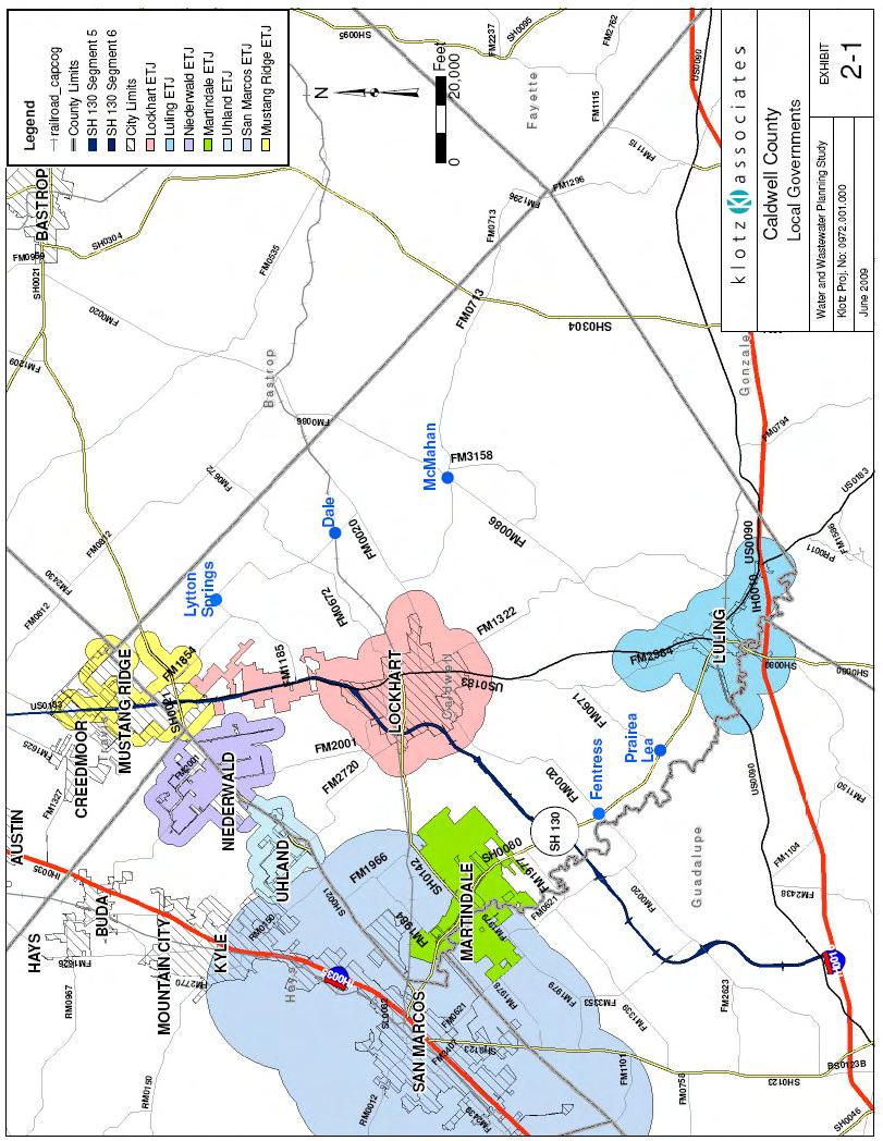
2 2-2
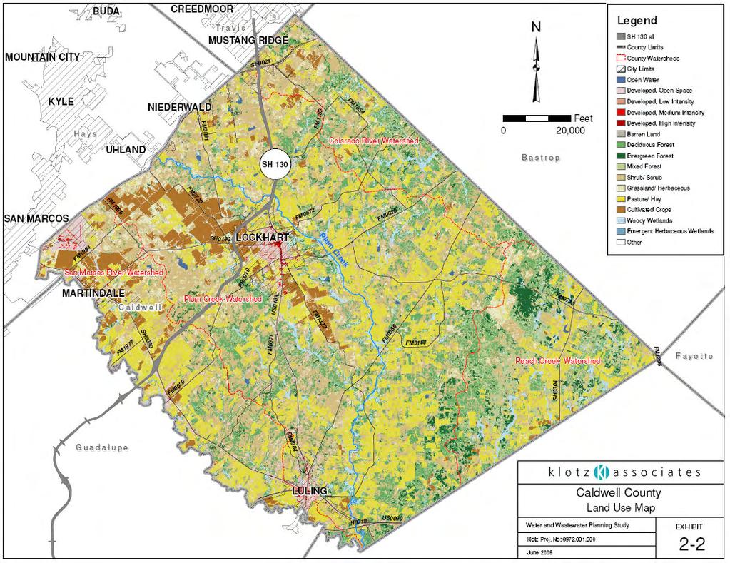
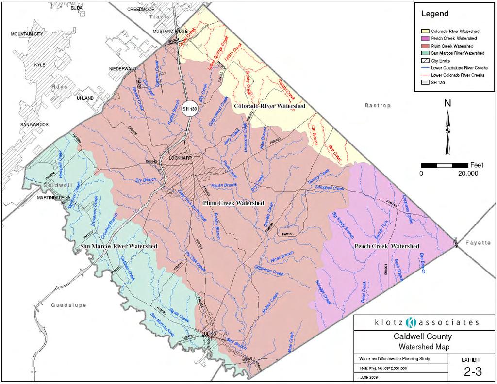
3 Construction for segments 5 and 6 of SH 130 is underway and completion is scheduled for the year Segment 5 will begin in Mustang Ridge and continue to north of Lockhart while Segment 6 will pick up at the southern end of Segment 5 and exit Caldwell County between Martindale and Fentress on the way to the intersection of SH 130 with I-10 near the City of Seguin in Guadalupe County. Approximately 40 miles of roadway will be constructed for these segments of SH 130. SH 130 will be a four lane divided highway. It will have direct connection to interchanges and provide ramps for access to non-toll lanes. SH 130 will be a toll road and it is anticipated that tolls may remain to fund maintenance and future local transportation projects. 2.2 Land Use Current land use within Caldwell County is illustrated by Exhibit 2-2 and was obtained from the United States Department of Agriculture (USDA). Land in Caldwell County is mostly undeveloped and is used as pastureland, grassland, forestland or cropland. The developed areas are primarily located along US Highway 183, SH 21 and SH 80. Current population density is greatest in the northwest and north central portions of the county because of the area s proximity to San Marcos, Austin and the I-35 corridor. The southern and southeast portions of the county, with the exception of Luling, remain largely rural in character in nature. The oil and gas industry has been an important part of the economy in Caldwell County but its footprint and impact on land use is relatively small. 2.3 Watersheds Land in Caldwell County drains primarily to the Guadalupe River Basin. Regional watersheds in the basin include the San Marcos Watershed, Plum Creek 2-3 Klotz Associates Project No
4 2-4
5 Watershed and Peach Creek Watershed. Exhibit 2-3 illustrates the major watershed boundaries in the county. A 58 square mile area in the northeastern corner of the county drains to the Colorado River Basin. The 58 square miles represents about 11 percent of the area of Caldwell County with the remaining 487 square miles draining to the Guadalupe River Basin. Plum Creek is the largest watershed in Caldwell County. Plum Creek rises in Hays County and enters Caldwell County near Niederwald. It then flows from north to south through the heart of Caldwell County and enters the San Marcos River at the Caldwell/Gonzales County line. At its mouth, Plum Creek has a drainage area of 397 square miles and a stream length of 52 river miles. Approximately 80 percent (319 square miles) of the Plum Creek Watershed is in Caldwell County. The 319 square miles of the Plum Creek Watershed in Caldwell County comprises about 59 percent of the total area within Caldwell County. Plum Creek is an important surface water feature in Caldwell County and the citizens of the county have a vested interest in protecting the character and health of this historic and highly-valued water course. The area within Caldwell County draining to the San Marcos River Watershed is 88 square miles or about 16 percent of the county. The San Marcos River flows south from the San Marcos city limits until it joins the Guadalupe River approximately 75 miles downstream near Gonzales, Texas. At its confluence with the Guadalupe River, the San Marcos River Basin has a total drainage area of 522 square miles. The San Marcos River is the western boundary of Caldwell County with a length along this boundary of 43 stream miles. The Peach Creek Watershed has a total drainage area of 480 square miles at its mouth with approximately 81 square miles (about 14 percent of the county) of the watershed in Caldwell County. Peach Creek joins the Guadalupe River near the community of Harmon in Gonzales County. Klotz Associates Project No
6 2-6
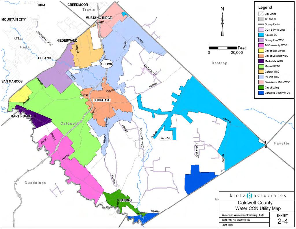
7 2.4 Certificates of Convenience and Necessity (CCN) In Caldwell County, there are twelve (12) water and four (4) wastewater utilities that hold a Certificate of Convenience and Necessity (CCN). A CCN is obtained by utilities for the purpose of defining a service area for municipal and public utility providers. A municipal utility defines a city, village or township and a public utility or water supply corporation (WSC) identifies a corporation or individual has ownership and responsibility Water CCN Utilities Caldwell County has twelve (12) water providers that serve portions of Caldwell County. Exhibit 2-4 outlines the areas within the CCN in Caldwell County that is held by the water service providers. The Texas Commission on Environmental Quality (TCEQ) provided the geographic information system (GIS) data through the Water Utility District (WUD) database. Luling and Lockhart are municipal utilities and the other providers are water supply corporations and special utility districts Wastewater CCN Utilities Wastewater utilities in the county are limited due to the largely rural land use in the county. Undeveloped areas rely on on-site sewage facilities (OSSF) for treatment and disposal of sewage. The TCEQ discharge permits that were identified are shown in Exhibit 2-5. Although Turner Crest Village LLC has obtained a wastewater discharge permit, the wastewater facilities have not been constructed. The intended service area is a large subdivision that will be developed based on demand for residential lots grows. Klotz Associates Project No
8 2-8
9 2-9
10 The City of Lockhart has two wastewater treatment plants that are operated and maintained by GBRA to serve the city residents. The facilities are located to the east of Lockhart. The City of Luling also has two municipal facilities each to serve the city. The facilities in Luling are located to the northeast and southwest of the city limits. 2.5 Climate The climate in Caldwell County is sub-tropical and humid. Low temperatures (40 degrees Fahrenheit (ºF)) occur in the months of January and December and high temperatures (95 ºF) occur in July and August. Average annual rainfall is approximately 37 inches per year and average the monthly precipitation varies from 1.8 inches in July to 4.4 inches in May. Table 2-1 presents the average temperatures, precipitation with record lows and highs as measured in the county at Lockhart, Texas. Graph 2-1 and Graph 2-2 graphically presents the information provided in the tables. TABLE 2-1 Lockhart, Texas Monthly Average Temperatures and Precipitation Average Average Average Record Record Month Mean High Low Precipitation High Low January 61 F 37 F F (1975) -3 F (1949) February 66 F 41 F F (1996) 4 F (1951) March 74 F 48 F F (1971) 17 F (2002) April 80 F 55 F F (1939) 26 F (1971) May 86 F 64 F F (1967) 40 F (1903) June 92 F 70 F F (1934) 50 F (1919) July 96 F 72 F F (1954) 58 F (1967) August 96 F 71 F F (1943) 56 F (1992) September 91 F 66 F F (2000) 41 F (1981) October 83 F 56 F F (1937) 26 F (1993) November 72 F 47 F F (1969) 19 F (1911) December 64 F 39 F F (1955) 4 F (1989) Klotz Associates Project No
11 GRAPH 2-1 Lockhart, Texas Monthly Average Temperatures Temperature (Farenheit) January February March April May June July August September October November December Month GRAPH 2-2 Lockhart, Texas Monthly Average Precipitation Precipitation January February March April May June July August September October November December Month Klotz Associates Project No
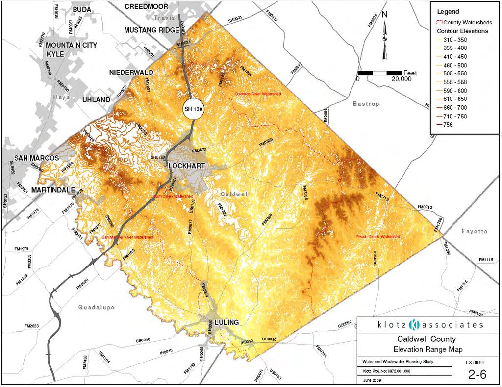
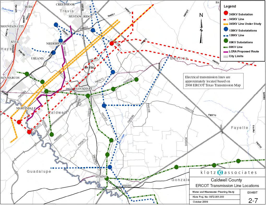
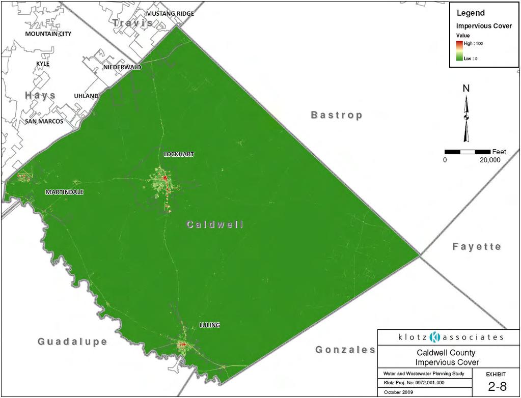
12 2.6 Topography The topography of Caldwell County is comprised of flat to rolling terrain with elevations ranging from 310 feet to approximately 750 feet above sea level. The highest elevations are in the northern part of the county and are in the range of 750 feet above mean sea level along the ridges that divide the San Marcos and Plum Creek watersheds. The lowest elevations are found in the southern portion of the county at the confluence of the San Marcos River and Plum Creek. The lowest elevation at the confluence is approximately 310 feet. Exhibit 2-6 illustrates elevation variances in the county. The elevation at Lockhart is about 515 feet and the elevation at Luling approximately 410 feet. 2.7 Transmission System The Transmission System in Caldwell County consist of a 345 KV transmission line with one Substation North of Lockhart, some138 KV transmission lines with 4 substations and several 69 KV transmission lines with 9 substations. Exhibit 2-7 illustrates the approximate line locations and identifies the northern area of the county with the most activity. The map was prepared using the ERCOT 2008 Texas Transmission Map. 2.8 Impervious Cover Impervious cover data obtained for Caldwell County indicates that the overall impervious cover percentage is approximately 0.6%. High impervious cover percentages are found in cities and near state roadways. Exhibit 2-8 illustrates impervious cover locations in the county. The red color in the map identifies the areas with a high value of impervious cover while the predominantly blue color symbolizes the most pervious areas. The impervious cover data was obtained from USGS spatial data. Klotz Associates Project No
13 2-13
14 2-14
15 2-15
CALDWELL COUNTY REGIONAL WATER AND WASTEWATER PLANNING STUDY
 CALDWELL COUNTY REGIONAL WATER AND WASTEWATER PLANNING STUDY Prepared for GUADALUPE-BLANCO RIVER AUTHORITY C O N S U L T I N G E N G I N E E R S 7 5 5 0 I H 1 0 W E S T, S U I T E 3 0 0 S A N A N T O N
SECTION 13 REGIONAL WASTEWATER PLANNING
 SECTION 13 REGIONAL WASTEWATER PLANNING 13.1 Introduction Regional wastewater planning is needed with the expected growth in Caldwell County. Evaluation of several options regarding collection treatment
SECTION 10 WATER QUALITY
 SECTION 10 WATER QUALITY 10.1 General Local ordinances in the Caldwell County political subdivisions regarding water quality and quantity issues are minimal. The county does not have authority to create,
3 PROJECT DESCRIPTION
 3.1 PROJECT OVERVIEW 3 PROJECT DESCRIPTION The Rocklin 60 project (proposed project) includes the subdivision of 56.9 acres of land, construction of 179 single-family, detached dwelling units, and installation
Peach Creek Watershed
 SH 304 Peach Creek Watershed Bastrop Peach Cree FM 713 Caldwell Peach Creek, Sandy Fork Copperas Creek 1803C Peach Creek Fayette FM 1054 US 90 Waelder US IH US 90 FM 1680 IH 10 Dry Run Gonzales SH 97 Peach
Gilleland Creek Intensive Bacteria Survey Addendum. March 18, 2010
 Gilleland Creek Intensive Bacteria Survey Addendum March 18, 21 Prepared by: Texas Stream Team Texas State University San Marcos PREPARED IN COOPERATION WITH THE TEXAS COMMISSION ON ENVIRONMENTAL QUALITY
Sandies Creek Watershed
 SH 97 Sandies Creek Watershed Gonzales De Witt FM 1116 Sandies Creek SH 72 FM 240 FM 466 Sandies Creek Karnes Smiley Elm Creek FM 108 US 87 SH 80 FM 1117 Guadalupe FM 1681 Wilson Nixon 13657 1803B 1803B
Water and Wastewater Impact Fee Analysis Capital Improvement Plan City of Lockhart February 2017
 TABLE OF CONTENTS 1.0 INTRODUCTION... 1 2.0 ANALYSIS OF WATER & WASTEWATER SYSTEMS... 1 2.1 Present Water Demands... 1 2.2 Water Supply... 3 2.3 Water Treatment Plant... 4 2.4 Storage, High-Service Pumps,
6. Pollutant Sources in
 6. Pollutant Sources in 45 6. Pollutant Sources in the Plum Creek Watershed The LDC analysis for Plum Creek indicates that both point and nonpoint sources contribute pollutants in the watershed. Identifying
Hammerhead Lease Prospect
 Hammerhead Lease Prospect CORPORATE OVERVIEW Reliance Oil and Gas, Inc. is an oil and gas drilling, operating and exploration company, incorporated under the laws of the State of Texas on July 1, 1985.
Sabine River Basin Big Sandy Creek Watershed Characterization Report 2015
 67. Big Sandy Big Sandy Creek at White Oak Road Station 16011 Sabine River Basin Big Sandy Creek Watershed Characterization Report 2015 Prepared in Cooperation with the Texas Commission on Environmental
EAST FORK SAN JACINTO RIVER - SEGMENT 1003
 EAST FORK SAN JACINTO RIVER - SEGMENT 1003 EAST FORK SAN JACINTO RIVER - SEGMENT 1003 LAND COVER BACTERIA Impairment Concern No Impairments or Concerns Perennial Stream Perennial Stream Segment Number:
Plum Creek Watershed Partnership Steering Committee Meeting. October 26, 2006 Lockhart, TX
 Plum Creek Watershed Partnership Steering Committee Meeting October 26, 2006 Lockhart, TX Texas Surface Water Quality Standards Charles Bayer Texas Commission on Environmental Quality Water Quality Assessment
Texas Groundwater Summit
 Guadalupe-Blanco River Authority Mid-Basin Water Supply Projects Texas Groundwater Summit James Lee Murphy, Esq. Executive Manager for Water Resources & Utility Operations Guadalupe-Blanco River Authority
N. IH-35 & HILLSIDE TERRACE (CR 133) BUDA, TEXAS /- ACRES IH-35 COMMERCIAL LAND FOR SALE. Sold. Site. Stonefield. LeadCommercial.
 BUDA, TEXAS /- ACRES IH-35 COMMERCIAL LAND FOR SALE. Sold. Site. Stonefield. LeadCommercial.") N. IH- & HILLSIDE TERRACE (CR 133) BUDA, TEXAS 1 +/- ACRES IH- COMMERCIAL LAND FOR SALE Sold Site Stonefield SUMMARY N. IH- & HILLSIDE TERRACE LOCATION The Horton Buda site has two tracts remaining totaling
N. IH- & HILLSIDE TERRACE (CR 133) BUDA, TEXAS 1 +/- ACRES IH- COMMERCIAL LAND FOR SALE Sold Site Stonefield SUMMARY N. IH- & HILLSIDE TERRACE LOCATION The Horton Buda site has two tracts remaining totaling
DEVELOPMENT REPORT UNION PACIFIC PROPERTY SAN ANTONO INTERMODAL YARD AREA
 DEVELOPMENT REPORT UNION PACIFIC PROPERTY SAN ANTONO INTERMODAL YARD AREA This report was prepared to present development information (Utility availability, Development Regulations, Flood Plain information,
Plum Creek. The Plum Creek Watershed. Your Water, Your Home. Watershed Partnership
 The Watershed Your Water, Your Home, Extension Water Quality Program Specialist I Mark McFarland, Professor and Extension Specialist Nikki Dictson, Extension Water Quality Program Specialist II Department
SAWS Role In Development of the Edwards Aquifer Recharge Zone
 SAWS Role In Development of the Edwards Aquifer Recharge Zone Presented by Annalisa Peace and Ron Green on behalf of the Greater Edwards Aquifer Alliance to the SAWS Board Development Task Force October
XI. Thornton Planning Area
 XI. A. OVERVIEW The covers 120 square miles in the northwest corner of San Joaquin County. It consists primarily of low-lying Delta islands, sloughs, and large farms. The town of Thornton, a small agriculturally-based
CITY OF SAN DIEGO COMMENTS ON THE SAFARI HIGHLANDS RANCH PROJECT (SUB ).
.") Attn: John Helmer 201 North Broadway Escondio, CA 92025 Submitted via email to: Jhelmer@escondido.org Subject: CITY OF SAN DIEGO COMMENTS ON THE SAFARI HIGHLANDS RANCH PROJECT (SUB 15-0019). The City of
Attn: John Helmer 201 North Broadway Escondio, CA 92025 Submitted via email to: Jhelmer@escondido.org Subject: CITY OF SAN DIEGO COMMENTS ON THE SAFARI HIGHLANDS RANCH PROJECT (SUB 15-0019). The City of
DROUGHT CONTINGENCY PLAN SUMMARY
 May 01, 2014 DROUGHT CONTINGENCY PLAN SUMMARY CANYON RESERVOIR Canyon Reservoir 8,200 surface acres -- Impounds 378,852 acre feet Conservation Pool Between 800 mean sea level (msl) and elevation of 909
2017 GROUNDWATER DISCHARGE AND USAGE
 2017 GROUNDWATER DISCHARGE AND USAGE 2018 2017 Groundwater Discharge and Usage Groundwater discharges from the Edwards Aquifer either as springflow or as pumping from wells. Comal and San Marcos springs,
EXECUTIVE SUMMARY DES PLAINES RIVER WATERSHED-BASED PLAN WHY A WATERSHED-BASED PLAN? WHAT IS A WATERSHED?
 Des Plaines River Watershed-Based Plan EXECUTIVE SUMMARY June 2018 EXECUTIVE SUMMARY DES PLAINES RIVER WATERSHED-BASED PLAN WHY A WATERSHED-BASED PLAN? Water is elemental to our lives. Plants and animals,
Texas State Highway 130 Proposed Routes
 Texas State Highway 130 Proposed Routes Submitted by: Mary Magnuson Tom Myatt April 12, 2000 Executive Decision Making Dr. Ernest Forman Table of Contents Executive Summary... 1 Background. 2 Alternatives.
Partnership Building Experiences
 Partnership Building Experiences in the Plum Creek Watershed Nikki Dictson Texas AgriLife Extension Service Improving Lives. Improving Texas. Watershed Protection Plan Pilot Project Texas AgriLife Extension
Appendix G Preliminary Hydrology Study
 Appendix G Preliminary Hydrology Study Preliminary Hydrology Study VESTING TTM 72608 Long Beach, CA Prepared for: The Long Beach Project, LLC 888 San Clemente, Suite 100 New Port Beach, CA May 28, 2014
Texas State Soil and Water Conservation Board Clean Water Act 319(h) Nonpoint Source Grant Program FY 2011 Workplan 11-07
 Nonpoint Source Grant Program FY 2011 Workplan 11-07") Page 1 of 14 Texas State Soil and Water Conservation Board Clean Water Act 319(h) Nonpoint Source Grant Program FY 2011 Workplan 11-07 SUMMARY PAGE Title of Project Coordinating Implementation of the Plum
Page 1 of 14 Texas State Soil and Water Conservation Board Clean Water Act 319(h) Nonpoint Source Grant Program FY 2011 Workplan 11-07 SUMMARY PAGE Title of Project Coordinating Implementation of the Plum
Introduction. Purpose
 Introduction This Master Plan update includes updating the text of the Utilities Section of the current Master Plan and adding a report concerning telecommunications. Each element examines the existing
EAST TORRANCE SOIL AND WATER CONSERVATION DISTRICT. LONG RANGE PLAN July 1, 2009 June 30, 2019
 EAST TORRANCE SOIL AND WATER CONSERVATION DISTRICT LONG RANGE PLAN July 1, 2009 June 30, 2019 INTRODUCTION The East Torrance Soil and Water Conservation District covers 1,142,028 acres of land in Torrance
Name of Project: Lake Dunlap and Wells Ranch Water Supply through Canyon Regional Water Authority
 Name of Project: Lake Dunlap and Wells Ranch Water Supply through Canyon Regional Water Authority Duration of Project: Lake Dunlap 1998-2038 / Wells Ranch: 2007-2047 Amount of Water Available Annually:
Geronimo and Alligator Creeks Watershed Steering Committee Meeting. February 9, 2010 GBRA River Annex Seguin, Texas
 Geronimo and Alligator Creeks Watershed Steering Committee Meeting February 9, 2010 GBRA River Annex Seguin, Texas Welcome and Introductions Debbie Magin Guadalupe Blanco River Authority Update on Additional
3.12 LAND USE AND PLANNING
 3.12 LAND USE AND PLANNING 3.12.1 INTRODUCTION This section describes the existing land uses in the project vicinity that could be affected by implementation of the Proposed Action and the alternatives.
DECEMBER P R O G R E S S R E P O R T
 DECEMBER 201 2 P R O G R E S S R E P O R T The My 35 Plan is a dynamic document and will continue to be re-evaluated and updated by the Committee as needed. The My 35 Plan contains the ideas and recommendations
Lubbock Outer Route Feasibility Study Report Executive Summary
 Lubbock Outer Route Feasibility Study Report Executive Summary Prepared for: Texas Department of Transportation Lubbock District Prepared by: MACTEC Engineering and Consulting, Inc. 6701 Aberdeen, Suite
Geronimo and Alligator Creeks Watershed Partnership Meeting. January 12, 2010
 Geronimo and Alligator Creeks Watershed Steering Committee Meeting February 9, 2010 GBRA River Annex Seguin, Texas Welcome and Introductions Debbie Magin Guadalupe Blanco River Authority Update on Additional
Table of Contents Part Title Page
 Table of Contents Part Title Page 1 System Information 1 2 Rate Structure 1 3 Conservation Goals 2 4 Implementation and Tracking 3 5 Conservation Measures 4 Appendix A Appendix B Appendix C Utility Profile
CITY OF ANGLETON MASTER DRAINAGE PLAN PHASE I EVALUATION & PRELIMINARY REPORT
 CITY OF ANGLETON MASTER DRAINAGE PLAN PHASE I EVALUATION & PRELIMINARY REPORT February 2008 Prepared by STOKES & ASSOCIATES, INC. 605 South Main Street, Suite 200 Henderson, Texas 75654 903-657-7558 TABLE
The Town of Chester Stormwater Mapping Report
 The Town of Chester Stormwater Mapping Report Prepared by the Warren County Soil & Water Conservation District December 2013 Table of Contents Introduction and Location 3 Stormwater Runoff 3 Assessment
Environmental Impact Statement; Lone Star Regional Rail Project Williamson, Travis, Bastrop, Hays, Caldwell, Comal, Guadalupe, and Bexar Counties, TX
 This document is scheduled to be published in the Federal Register on 10/06/2014 and available online at http://federalregister.gov/a/2014-23711, and on FDsys.gov [4910-22] DEPARTMENT OF TRANSPORTATION
SOUTH BRANCH SUBWATERSHED
 SOUTH BRANCH SOUTH BRANCH SUBWATERSHED The South Branch Subwatershed includes the South Branch drainage area plus all the drainage area along the main stream to the south from the mouth of Surrena Run
acquiring, managing, and disposing of federal lands and facilities;
 2.2.1 HYDROLOGY AND FLOODPLAIN This section discusses and analyzes the surface hydrology and water quality characteristics of the project. The information provided in this section is based on the Preliminary
Why Is The Hillsborough River Watershed Important? A Practice Timed Writing Exercise
 Why Is The Hillsborough River Watershed Important? A Practice Timed Writing Exercise Essential Question: Why is the Hillsborough River Watershed important? Objective: Students will write an expository
Section 14. Energy Pipeline Failures
 ntents Section 14. Energy Failures Why Failures Are a Threat...14-1 Hazard Profile...14-2 Location of Hazardous Areas...14-3 History of Failures...14-4 People and at Risk... 14-13 Potential s and Losses...
Review Zone Application for D&R Canal Commission Decision
 Review Zone Application for D&R Canal Commission Decision MEETING DATE: January 18, 2017 DRCC #: 16-3020C Latest Submission Received: January 10, 2016 Applicant: PVP Franklin, LLC 769 Northfield Avenue,
Plum Creek Watershed Partnership Meeting. Lockhart, Texas August 8, 2013
 Plum Creek Watershed Partnership Meeting Lockhart, Texas August 8, 2013 Watershed Coordinator Update Community Clean Up Events Plum Creek Watershed Feral Hog Projects Project Briefings Plum Creek Internship
Project Alignment Appendix A
 Project Alignment Appendix A Fargo Moorhead Metropolitan Area Flood Risk Management Project EA Document This page is intentionally left blank Project Alignment Appendix A Table of Contents 1 BACKGROUND...
Capturing Storm Water in Semi-arid Climate
 Capturing Storm Water in Semi-arid Climate REBEKA SULTANA, PHD CALIFORNIA STATE UNIVERSITY, LONG BEACH NATHANIEL SUMMERVILLE, PE CALIFORNIA STATE UNIVERSITY LONG BEACH (STUDENT PROJECT MANAGER) AND CH2M
NOTICE OF MEETING GUADALUPE-BLANCO RIVER AUTHORITY BOARD OF DIRECTORS
 NOTICE OF MEETING GUADALUPE-BLANCO RIVER AUTHORITY BOARD OF DIRECTORS In accordance with the provisions of the Texas Open Meetings Act, Chapter 551, Texas Government Code, the Guadalupe-Blanco River Authority
A Report on the Montgomery County s Existing and Possible Tree Canopy
 A Report on the Montgomery County s Existing and Why is Tree Canopy Important? Tree canopy (TC) is the layer of leaves, branches, and stems of trees that cover the ground when viewed from above. Tree canopy
Blanco River Watershed
 RM 1376 RM 484 FM 3353 RM 1631 RM 1376 Meier Creek RM 2721 GILLESPIE RR 1 Delaware Creek RM 1888 KENDALL Falls Creek Crabapple Creek RM 1320 Big Creek Cottonwood Creek 12668-G Koch Branch Schuetz Creek
SECTION 1 - TRANSPORTATION NETWORK SECTION 2 - SITE INFORMATION
 TABLE OF CONTENTS SECTION 1 - TRANSPORTATION NETWORK INTERSTATE AVAILABILITY (MAP): TEXAS INTERSTATE HIGHWAYS TEXAS SOUTH LOOP 9 PROJECT (AERIAL PHOTO): PROPOSED ROUTE (TXDOT MAJOR ROADWAY) TEXAS SOUTH
Review Zone Application for D&R Canal Commission Decision
 Review Zone Application for D&R Canal Commission Decision MEETING DATE: June 15, 2016 DRCC #: 15-4748 Phase I and II Latest Submission Received: May 4, 2016 Applicant: Kevin Hayes Country Club Meadows,
SAN BERNARD RIVER ABOVE TIDAL - SEGMENT 1302
 SAN BERNARD RIVER ABOVE TIDAL - SEGMENT 1302 SAN BERNARD RIVER ABOVE TIDAL - SEGMENT 1302 LAND COVER BACTERIA DISSOLVED OXYGEN NUTRIENTS Impairment Concern No Impairments or Concerns SAN BERNARD RIVER
Lower South Mayde Creek Flood Risk Reduction Effort. Jonathan St. Romain, P.E. Project Manager. March 21, 2018
 Lower South Mayde Creek Flood Risk Reduction Effort Jonathan St. Romain, P.E. Project Manager March 21, 2018 Overview 1. Overview of Harris County Flood Control District (HCFCD) 2. Current conditions 3.
Guadalupe River Basin Clean Rivers Program Steering Committee Annual Meeting. March 22, Minutes
 Guadalupe River Basin Clean Rivers Program Steering Committee Annual Meeting March 22, 2012 Minutes (Changes to 2013 Coordinated Monitoring Schedules to follow) The annual meeting of the Clean Rivers Program
4 EXISTING FACILITIES EVALUATION
 4 EXISTING FACILITIES EVALUATION The City is served by a combination of wastewater collection, conveyance, and treatment systems. The City owns and operates the collection system that collects wastewater
SACRAMENTO LOCAL AGENCY FORMATION COMMISSION 1112 I Street, Suite 100 Sacramento, California (916) April 1, 2015
 April 1, 2015") SACRAMENTO LOCAL AGENCY FORMATION COMMISSION 1112 I Street, Suite 100 Sacramento, California 95814 (916) 874-6458 April 1, 2015 Agenda Item No 12 TO: FROM: RE: Sacramento Local Agency Formation Commission
SACRAMENTO LOCAL AGENCY FORMATION COMMISSION 1112 I Street, Suite 100 Sacramento, California 95814 (916) 874-6458 April 1, 2015 Agenda Item No 12 TO: FROM: RE: Sacramento Local Agency Formation Commission
Plum Creek Watershed Protection Plan
 Plum Creek Watershed Protection Plan 1 Developed by THE PLUM CREEK WATERSHED PARTNERSHIP February 2008 Photos courtesy of Nikki Dictson, Texas AgriLife Extension Service JupiterImages Corporation USDA-NRCS
Transportation Facility Inventory
 CHAPTER 3 Transportation Element Section 3.1 Introduction Movement of people, goods, and services within and through the Town is an integral part of everyday life for the citizens of Hull. Decisions made
4.16 UTILITIES AND SERVICE SYSTEMS
 4.16 UTILITIES AND SERVICE SYSTEMS This section evaluates the effects of the proposed project with regard to utilities and service systems by identifying anticipated demand and existing and planned utility
Walker County Manufactured Home Rental Community Regulations Infrastructure Development Plan
 A. In accordance with Local Government Code Section 232.007, an Infrastructure Development Plan (IDP) is required for all manufactured home rental communities, as defined in Section A 1.0 E of these regulations,
SEWRPC Staff Memorandum
 SEWRPC Staff Memorandum EVALUATION OF PROPOSED STORMWATER QUANTITY MANAGEMENT FOR THE DES PLAINES RIVER WATERSHED PORTION OF THE PROPOSED FOXCONN DEVELOPMENT IN THE VILLAGE OF MOUNT PLEASANT June, 2018
Buffalo Creek Watershed-Based Plan EXECUTIVE SUMMARY
 Buffalo Creek Watershed-Based Plan EXECUTIVE SUMMARY Prepared for Buffalo Creek Clean Water Partnership By Cardno August 2015 What you will find inside this Executive Summary 1. Introduction 2. Purpose
PEARCE CREEK CONFINED DISPOSAL AREA MODIFICATION
 US Army Corps of Engineers Philadelphia District PEARCE CREEK CONFINED DISPOSAL AREA MODIFICATION CECIL COUNTY MARYLAND STORMWATER MANAGEMENT PLAN NARRATIVE INITIAL SUBMISSION JUNE 2014 1 PEARCE CREEK
Chapter 9: Vision Plan. Chapter 9. Vision Plan. Lake Loveland. Image 179 Credit: City of Loveland
 Chapter 9 Vision Plan Lake Loveland. Image 179 Credit: City of Loveland Chapter 9: Vision Plan A. Regionally Significant Corridor and Regional Bike Corridor Visions Corridor visioning seeks to develop
LOCATION HYDRAULICS REPORT. SR 60 GRADE SEPARATION AT CSX RAILROAD PROJECT DEVELOPMENT AND ENVIRONMENT STUDY Polk County, Florida
 LOCATION HYDRAULICS REPORT SR 60 GRADE SEPARATION AT CSX RAILROAD PROJECT DEVELOPMENT AND ENVIRONMENT STUDY Polk County, Florida Financial Project ID: 436559-1-22-01 Prepared for: FLORIDA DEPARTMENT OF
PROJECT SCOPE OF WORK CITY OF TOWN AND COUNTRY STORMWATER PROGRAM
 PROJECT SCOPE OF WORK CITY OF TOWN AND COUNTRY STORMWATER PROGRAM Project Name: Essex Point Subdivision/Sellenriek Retention Project ID Number: 2-A Problem: The watershed above the Essex Point Subdivision
PRELIMINARY DRAINAGE STUDY
 PRELIMINARY DRAINAGE STUDY For 34 th & J Residences 3402 J St. San Diego, CA 92102 A.P.N 545-250-08 Prepared By: Kenneth J. Discenza, P.E. Site Design Associates, Inc. 1016 Broadway, Suite A El Cajon,
2004 FEASIBILITY STUDY UPDATE
 Austin-San Antonio Intermunicipal Commuter Rail District 2004 FEASIBILITY STUDY UPDATE December 2004 EXECUTIVE SUMMARY INTRODUCTION Almost 3 million people in Central Texas, living and working between
CEDAR RUN WATERSHED ACT 167 STORMWATER MANAGEMENT PLAN FINAL REPORT
 CEDAR RUN WATERSHED ACT 167 STORMWATER MANAGEMENT PLAN FINAL REPORT I. PURPOSE OF THE REPORT The purpose of this report is to summarize the findings and recommendations of the Cedar Run Watershed Act 167
TABLE OF CONTENTS 4.17 UTILITIES AND SERVICE SYSTEMS...
 TABLE OF CONTENTS 4.17 UTILITIES AND SERVICE SYSTEMS... 4.17-1 4.17.0 Introduction... 4.17-1 4.17.1 Methodology... 4.17-2 4.17.2 Existing Conditions... 4.17-2 4.17.3 Impacts... 4.17-4 4.17.4 Applicant-Proposed
Air Quality Analysis Technical Memorandum
 Air Quality Analysis Technical Memorandum Segment 4: State Road 400 (SR 400)/Interstate 4 (I-4) from East of SR 15-600/US 17-92 (Seminole/Volusia County Line) to ½ Mile East of SR 472 Volusia County (79110),
SECTION 1.0 INTRODUCTION
 SECTION 1.0 INTRODUCTION SECTION 1.0 INTRODUCTION 1.1 INTRODUCTION This Environmental Assessment (EA) has been prepared for the U.S. Bureau of Indian Affairs (BIA) to support an application from the Lytton
Appendix F. To the. Guadalupe Blanco River Authority And Upper Guadalupe River Authority Clean Rivers Program FY
 Appendix F To the Guadalupe Blanco River Authority And Upper Guadalupe River Authority Clean Rivers Program FY 2002-03 Investigation of elevated sulfate concentrations in the Upper Blanco River Phase I
Municipal Stormwater Management Plan Prepared For The Borough of Cape May Point By Van Note-Harvey Associates VNH File No.
 Municipal Stormwater Management Plan Prepared For The Borough of Cape May Point By Van Note-Harvey Associates 2005 VNH File No. 35317-210-21 Table of Contents Introduction... 3 Goals... 3 Storm water Discussion...
HYDROLOGY STUDY PREPARED FOR: MARKHAM PERRIS LLC 302 WEST FIFTH STREET, SUITE 103 SAN PEDRO, CA (310) FOR THE PROJECT:
 FOR THE PROJECT:") HYDROLOGY STUDY PREPARED FOR: MARKHAM PERRIS LLC 302 WEST FIFTH STREET, SUITE 103 SAN PEDRO, CA 90731 (310) 241-2992 FOR THE PROJECT: PERRIS VALLEY COMMERCE CENTER BUILDING PERRIS, CALIFORNIA PROJECT NUMBER:
HYDROLOGY STUDY PREPARED FOR: MARKHAM PERRIS LLC 302 WEST FIFTH STREET, SUITE 103 SAN PEDRO, CA 90731 (310) 241-2992 FOR THE PROJECT: PERRIS VALLEY COMMERCE CENTER BUILDING PERRIS, CALIFORNIA PROJECT NUMBER:
City of Dade City AMEC Project No Dade City Stormwater Master Plan September 2012 Page 11
 Page 11 1.0 INTRODUCTION This report was prepared for the City of Dade City to provide an overview of the existing stormwater management challenges that the City faces. The report is intended to assist
Public Notice ISSUED: 11 February 2019 EXPIRES: 13 March 2019
 SPONSOR: Minnesota Board of Water and Soil Resources Public Notice ISSUED: 11 February 2019 EXPIRES: 13 March 2019 REFER TO: MVP-2019-0122-JTB SECTION: 404 - Clean Water Act 1. WETLAND COMPENSATORY MITIGATION
COMPREHENSIVE PLAN Executive Summary C ITY OF ENNIS, TEXAS
 COMPREHENSIVE PLAN 2000-2020 Executive Summary CITY OF ENNIS, TEXAS COMPREHENSIVE PLAN 2000 2020 EXECUTIVE SUMMARY! The Future Land Use Plan! Public Facilities Plan (Map) Table of Contents! Parks, Recreation
Background. Literature Review
 Ms. Joanna Helms Economic Development Director Town of Apex 73 Hunter Street P.O. Box 250 Apex, North Carolina 27502 October 23, 2015 Reference: Report of Wetland Determination Cash Perkins Site ECS Project
Water and Wastewater Facilities Land Use Assumptions Plan, Capital Improvements Plan, and Maximum Impact Fees Study. San Antonio Water System
 Carollo Engineers, Inc. 114785 Preston Rd., Ste. 950 Dallas, TX 75254 carollo.com Water and Wastewater Facilities Land Use Assumptions Plan, Capital Improvements Plan, and Maximum Impact Fees Study DRAFT
ELDERBERRY CUSA EXPANSION SUMMARY INFORMATION
 ELDERBERRY CUSA EXPANSION SUMMARY INFORMATION This information is provided to support the City of Madison s request to expand the Central Urban Service Area (CUSA) to include approximately 302.6 acres
SECTION III: WATERSHED TECHNICAL ANALYSIS
 Trout Creek Watershed Stormwater Management Plan SECTION III: WATERSHED TECHNICAL ANALYSIS A. Watershed Modeling An initial step this study of the Trout Creek watershed was the selection of a stormwater
SUPPLEMENTAL DRAFT ENVIRONMENTAL IMPACT STATEMENT NORTH BELT FREEWAY SUMMARY INTRODUCTION
 SUMMARY INTRODUCTION The Arkansas State Highway and Transportation Department (AHTD), in cooperation with the Federal Highway Administration (FHWA), is proposing a highway project located in northern Pulaski
INVESTIGATING WATERSHEDS
 NAME DATE PARTNER(S) INVESTIGATING WATERSHEDS Rainfall or any form of precipitation collects on lawns, streets, and fields and runs directly into streams or into storm drains (where it is piped to streams).
Plum Creek Watershed Partnership
 Plum Creek Watershed Partnership Program Updates 2015 Clean Rivers Program March 26, 2015 The Plum Creek Watershed 397 square mile drainage Tributary to the San Marcos River Plum Creek was placed on the
Texas Watch Volunteer Water Quality Monitoring Program 2006 Mary s Creek Data Summary
 Texas Watch Volunteer Water Quality Monitoring Program 26 Mary s Creek Data Summary Narrative Summary of Mary s Creek Mary s Creek is an unclassified, perennial stream flowing 6 miles southwest from Pearland,
Infrastructure. 7.1 Overview Goals, Objectives, and Policies A. Stormwater Management B. Sanitary Sewer System...
 Infrastructure 7 7 Infrastructure 7.1 Overview... 7-1 7.2 Goals, Objectives, and Policies..... 7-3 A. Stormwater Management..... 7-3 B. Sanitary Sewer System... 7-4 7.0 Infrastructure 7.1 OVERVIEW Priority
9.0 General Infrastructure Element
 9.0 PURPOSE The purpose of this element is to ensure adequate provision of public facilities and services required to meet the future needs of the University, including the following: a) Ensure provision
Chapter 2: Conditions in the Spring Lake Watershed related to Stormwater Pollution
 Chapter 2: Conditions in the Spring Lake Watershed related to Stormwater Pollution To identify the primary causes and consequences of stormwater discharges to Spring Lake and its adjoining waterbodies,
Ward Ling Texas A&M AgriLife Extension Service
 Ward Ling Texas A&M AgriLife Extension Service Geronimo and Alligator Creeks Watershed Watershed Overview 90% in agricultural production and shrinking Majority in livestock production, rest in row crop
YOUR GATEWAY TO GLOBAL DISTRIBUTION
 YOUR GATEWAY TO GLOBAL DISTRIBUTION INDUSTRIAL DEVELOPMENT SITE DLH PARCEL #44 9.954 GROSS ACRES DLH PARCEL #45 10.83 GROSS ACRES DLH PARCEL #47C 5.7+/- GROSS ACRES 4300 TELEPHONE ROAD DALLAS, TEXAS T
YOUR GATEWAY TO GLOBAL DISTRIBUTION
 YOUR GATEWAY TO GLOBAL DISTRIBUTION INDUSTRIAL DEVELOPMENT SITE DLH PARCEL #44 9.954 GROSS ACRES DLH PARCEL #45 10.83 GROSS ACRES DLH PARCEL #47C 5.7+/- GROSS ACRES 4300 TELEPHONE ROAD DALLAS, TEXAS T
LAKE COUNTY HYDROLOGY DESIGN STANDARDS
 LAKE COUNTY HYDROLOGY DESIGN STANDARDS Lake County Department of Public Works Water Resources Division 255 N. Forbes Street Lakeport, CA 95453 (707)263-2341 Adopted June 22, 1999 These Standards provide
Hill Country Alliance Presentation
 Hill Country Alliance Presentation September 24, 2015 Lone Star Regional Rail Strategic Considerations Lone Star Rail District Connectivity/Mobility Issues 1 Lone Star Regional Rail Strategic Considerations
Prior Lake Stormwater Management & Flood Mitigation Study
 Prior Lake Stormwater Management & Flood Mitigation Study Prepared for Prior Lake-Spring Lake Watershed District and the City of Prior Lake September, 2016 4300 MarketPointe Drive, Suite 200 Minneapolis,
Goose Creek Watershed Assessment Summary October 2003
 Goose Creek Watershed Assessment Summary October 2003 The Goose Creek Watershed The Goose Creek watershed is 385 square miles, covering nearly half of Loudoun County and one-quarter of Fauquier County
Land Use Assumptions Technical Memorandum
 San Antonio Water System Water and Wastewater Facilities Land Use Assumptions Plan, Capital Improvements Plan, and Maximum Impact Fees Study Land Use Assumptions Technical Memorandum November 2018 Contents
SOURCE WATER ASSESSMENT SUMMARY BROCHURE
 SOURCE WATER ASSESSMENT SUMMARY BROCHURE MILL CITY WATER DEPARTMENT PWS # 4100520 WHAT IS A SOURCE WATER ASSESSMENT? The Source Water Assessment was recently completed by the Department of Environmental
Appendix K Civil Engineering
 Appendix K Civil Engineering Fargo-Moorhead Metropolitan Area Flood Risk Management Final Feasibility Report and Environmental Impact Statement Prepared by: U.S. Army Corps of Engineers St. Paul District