Intersection of SAR imagery with medium resolution DEM for the estimation of regional water storage changes
|
|
|
- Sharyl Hopkins
- 6 years ago
- Views:
Transcription


, München,")
1 Intersection of SAR imagery with medium resolution DEM for the estimation of regional water storage changes Sonya Spiridonova 1, Karin Hedman 1, Florian Seitz 2 1 Earth Oriented Space Science and Technology (ESPACE), TU München, Germany 2 Deutsches Geodätisches Forschungsinstitut (DGFI), München, Germany October 11, 2012
 and November (drought).")

2 Background 2 Previous study (GRACE data analysis) in the Amazon basin: huge change of water storage within the continental hydrology between two extreme events in April ( flood of the century [State of the Climate]) and November (drought). How are such mass variations and related effects reflected in other contemporary observation systems (satellite altimetry, SAR/optical remote sensing, gauges, ) Potential and spatial/temporal consistency of observed changes of water mass and water surface extent caused by extreme weather situations Can these techniques be used to infer alternative estimates for mass variations that could be compared with GRACE?
3 Total water storage change from GRACE Analysis of 97 monthly GRACE solutions (August 2002 and March 2011) GFZ RL04 (degree/order =70), reduced by mean field over the entire period Treatment of mission-specific errors in the Level-2 data ( stripes due to satellite orbit characteristics and high-frequent aliasing of to non-modeled mass variations): - Reduction of correlated errors by a least squares polynomial filer - Filtering of noisy short wavelength components using an isotopic Gaussian filter with a half-width of 300km. 3
4 4 Total water storage change from GRACE
5 Total water storage change from GRACE 5 Change between the absolute maximum and the absolute minimum of the curve within only half a year

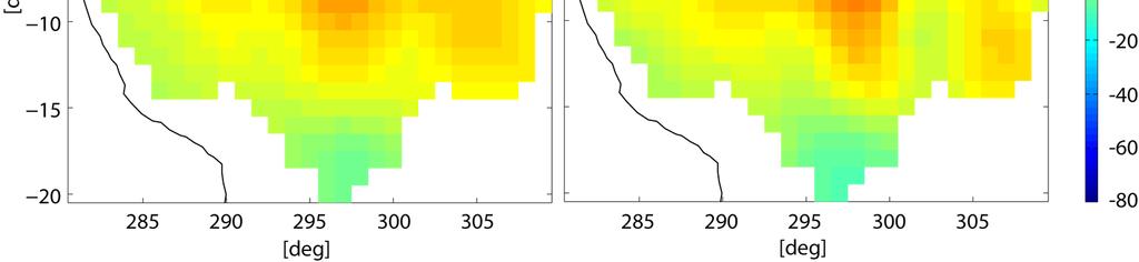
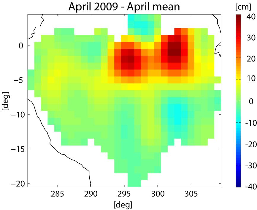
6 extreme conditions in GRACE April 2009 anomaly


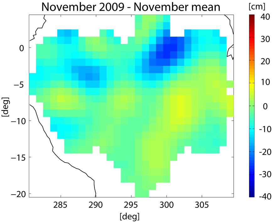
7 extreme conditions in GRACE Nov anomaly
8 2009 extreme conditions in GRACE 8 Dec Apr. 2009: heavy rainfall, 100% above normal in the north (Rio Negro) and the northeast Flood 2009: highest ever registered water levels of Rio Negro and Amazon Above average (2-3 C) temperatures from June 2009 in the North-East ENSO-related below average precipitation in the last three months of 2009

9 9 Observations of water levels Water level at Obidos Water level at Manacapuru
 onboard ALOS")
 Swath")
10 Observations of water surface extent 10 Phased Array type L-band Synthetic Aperture Radar (PALSAR) onboard ALOS L-band is especially useful in areas covered by vegetation ScanSAR wide beam mode (100 m spatial resolution) Swath width ~300 km
11 Observations of water surface extent 11 Flooded open water areas appear as dark areas Flooded areas with vegetation appear as bright areas (double bounce)

12 Observations of water surface extent 12 Flooded open water areas appear as dark areas Flooded areas with vegetation appear as bright areas (double bounce)


13 Observations of water surface extent S. Spiridonova et al. April 2009 Rough estimation of flooded area: Geodätische Woche 2012, Hannover 13 Total area of each image: ~ 12 Mio Pixel ~ km² Application of a simple threshold for dark and bright pixels based on image histogram. [Meyer, 2004; Hedman, 2010]


14 14 Observations of water surface extent April 2009 Black: areas under water [Meyer, 2004; Hedman, 2010]
15 Observations of water surface extent April 2009 Area covered by water: larger by about 12% in April 15 ALOS PALSAR images are a useful source of information for the detection of areas covered by water Periods of flood and drought are clearly distinguishable November 2009


16 Towards the assessment of water volume changes Estimation of water mass variations in the regime of surface water between extreme situations from volume changes: Geometrical intersection of surface water mask with a DEM Data from gauges and altimetry as vertical constraints ACE-2 DEM: Combination of SRTM data with satellite altimetry Horizontal resolution ~ 90 m 16


17 Step 1: Generation of the water mask Generate water mask, reduce speckle, extract the largest connected component, intersect the boundary with DEM using transformation polynomials. Speckle reduction Intersection Threshold Largest component River boundary [Hedman, 2012] 17

18 Step 2: Computation of water heights along the river boundary Derive the heights along the boundary, process for error reduction. Extract constant segments Errors in heights are caused by displacements of the river boundary w.r.t. the DEM Remove very short segments and then interpolate in gaps Interpolate heights in gaps 18


19 19 Water height differences (April November 2009) Longitude
20 Resume & Outlook Extreme events (e.g. floods, droughts) are clearly identifiable in the analysed data sets from GRACE, satellite altimetry, SAR and in-situ gauges Next step: Volume computation How do volume changes compare with GRACE mass variations? Problems and challenges: coarse horizontal resolution of SAR scenes and DEM (~90 m) large uncertainty of computed volume no bathymetry information available small flooded areas are even more difficult to intersect incorporation of information on water stages: altimetry, gauges comparability of GRACE and geometrical approach Multi-sensor data combinations are an important step towards the separation of integral geodetic signals 20
21 21 END
22 Total water storage change from GRACE GRACE accuracy: 1-2 cm EWH (~ km³) DDK1 / DDK3: Results from two versions of non-isotropically smoothed GFZ RL04 solutions [Kusche et al., 2007]. DDK1 smoothes over larger areas than DDK3. 22
23 Total water storage change from GRACE Worst drought since 40 years Record low water levels Dec Apr. 2009: heavy rainfall, 100% above normal in the north (Rio Negro) and the northeast Flood 2009: highest ever registered water levels of Rio Negro and Amazon severe damage and impact on humans and wildlife Above average (2-3 C) temperatures from June 2009 in the North-East ENSO-related below average precipitation in the last three months of
 Swath width ~300")
24 Observations of water surface extent 24 Phased Array type L-band Synthetic Aperture Radar (PALSAR) onboard ALOS L-band is especially useful in areas covered by vegetation ScanSAR wide beam mode (100 m spatial resolution) Swath width ~300 km
25 Approach SAR image data (high and low water levels) Extract water mask from SAR data Extract the largest connected component as the primary water body DEM Intersect water boundaries with DEM and extract boundary heights Altimetry data Interpolate water heights Estimation of water mass variations 25
Taikichiro Mori Memorial Research Grants Graduate Student Researcher Development Grant Report
 Taikichiro Mori Memorial Research Grants Graduate Student Researcher Development Grant Report February 2016 Research Project: Detection and delineation of water bodies using Synthetic Aperture Radar data
A new method to estimate rice crop production and outlook using Earth Observation satellite data
 A new method to estimate rice crop production and outlook using Earth Observation satellite data Toshio Okumura, Shin-ich Sobue, Nobuhiro Tomiyama RESTEC Kei Ohyoshi JAXA 17 Feb. 2014 Don Chan Palace,
Role of Remote Sensing in Flood Management
 Role of Remote Sensing in Flood Management Presented by: Victor Veiga (M.Sc Candidate) Supervisors: Dr. Quazi Hassan 1, and Dr. Jianxun He 2 1 Department of Geomatics Engineering, University of Calgary
Using multi-temporal ALOS PALSAR to investigate flood dynamics in semi-arid wetlands: Murray Darling Basin, Australia.
 Using multi-temporal ALOS PALSAR to investigate flood dynamics in semi-arid wetlands: Murray Darling Basin, Australia. Rachel Melrose, Anthony Milne Horizon Geoscience Consulting and University of New
Malawi Multi-purpose use of ALOS PALSAR-1 data. sarmap and Forest Research Institute of Malawi (FRIM)
") Malawi Multi-purpose use of ALOS PALSAR-1 data sarmap and Forest Research Institute of Malawi (FRIM) Objective The objective is to demonstrate, at country-level, the multi-purpose use of ALOS PALSAR-1
Malawi Multi-purpose use of ALOS PALSAR-1 data sarmap and Forest Research Institute of Malawi (FRIM) Objective The objective is to demonstrate, at country-level, the multi-purpose use of ALOS PALSAR-1
River Levels Derived with CryoSat-2 SAR Data Classification A Case Study in the Mekong River Basin
 remote sensing Article River Levels Derived with CryoSat-2 SAR Data Classification A Case Study in the Mekong River Basin Eva Boergens 1, * ID, Karina Nielsen 2 ID, Ole Baltazar Andersen 2, Denise Dettmering
FY24 28 JAXA. Big BCG
 RESTEC 26 1 31 2 FY24 28 JAXA 37 3 Big BCG 4 ( + + ) National Spatial Data Infrastructure Theme Maps (1/5,000, 1/10,000,1/25,000, 1/50,000) ( ) GIS ADB GSMaP Input Rain gage Improved Flood prediction model
River levels derived with CryoSat-2 SAR data classification - A case study in the Mekong River Basin
 Downloaded from orbit.dtu.dk on: Oct 17, 218 River levels derived with CryoSat-2 SAR data classification - A case study in the Mekong River Basin Boergens, Eva; Nielsen, Karina; Andersen, Ole Baltazar;
Big Data in Water: Opportunities and Challenges for Machine Learning
 2018 Water Resources Assembly and Research Symposium Headwaters Lecture Big Data in Water: Opportunities and Challenges for Machine Learning Vipin Kumar Department of Computer Science and Engineering University
the wheat fields is small, and as for fields of puddling and leveling in winter and other fields in similar, the difference is small. It is conclude t
 OBSERVATION OF JAPANESE PADDY RICE FIELDS USING MULTI TEMPORAL AND POLARIMETRIC PALSAR DATA PI No.365 Naoki ISHITSUKA 1, Genya SAITO 2, Fan YANG 3, Chinatsu YONEZAWA 4 and Shigeo OGAWA 5 1 National Institute
Product Delivery Report for K&C Phase 3. Francesco Holecz sarmap
 Product Delivery Report for K&C Phase 3 Francesco Holecz sarmap Science Team meeting #21 Phase 3 Result Presentations Kyoto Research Park, Kyoto, Japan, December 3-4, 2014 Project objectives The objective
Surface Water and Ocean Topography (SWOT) Mission. Lake Vector Products Tamlin Pavelsky and Jean-Francois Cretaux
 Mission. Lake Vector Products Tamlin Pavelsky and Jean-Francois Cretaux") Surface Water and Ocean Topography (SWOT) Mission Lake Vector Products Tamlin Pavelsky and Jean-Francois Cretaux SWOT Science Definition Team Meeting, July 7-9, 2015 Proposed Vector Data Products Pass-based
Surface Water and Ocean Topography (SWOT) Mission Lake Vector Products Tamlin Pavelsky and Jean-Francois Cretaux SWOT Science Definition Team Meeting, July 7-9, 2015 Proposed Vector Data Products Pass-based
FOREST AND FOREST CHANGE MAPPING WITH C- AND L-BAND SAR IN LIWALE, TANZANIA
 FOREST AND FOREST CHANGE MAPPING WITH C- AND L-BAND SAR IN LIWALE, TANZANIA J. Haarpaintner a, C. Davids a, H. Hindberg a, E. Zahabu b, R.E. Malimbwi b a Norut, P.O. Box 6434, Tromsø Science Park, N-9294
Improving flood inundation monitoring and modelling using remotely sensed data
 Improving flood inundation monitoring and modelling using remotely sensed data Article Accepted Version Mason, D., Garcia Pintado, J. and Dance, S. (2014) Improving flood inundation monitoring and modelling
3/1/18 USING RADAR FOR WETLAND MAPPING IMPORTANCE OF SOIL MOISTURE TRADITIONAL METHODS TO MEASURE SOIL MOISTURE. Feel method Electrical resistance
 3/1/18 USING RADAR FOR WETLAND MAPPING SOIL MOISTURE AND WETLAND CLASSIFICATION Slides modified from a presentation by Charlotte Gabrielsen for this class. Southeast Arizona: Winter wet period From C.
Integration of Alos PalSAR and LIDAR IceSAT data in a multistep approach for wide area biomass mapping
 Integration of Alos PalSAR and LIDAR IceSAT data in a multistep approach for wide area biomass mapping. Above Ground Biomass (carbon) mapping and monitoring: Importance Supporting UNFCC KP, REDD+, Monitoring
LAND AND WATER - EARTH OBSERVATION INFORMATICS FSP
 Earth Observation for Water Resources Management Arnold Dekker,Juan P Guerschman, Randall Donohue, Tom Van Niel, Luigi Renzullo,, Tim Malthus, Tim McVicar and Albert Van Dijk LAND AND WATER - EARTH OBSERVATION
RADAR for Biomass Mapping
 RADAR for Biomass Mapping Josef Kellndorfer Wayne Walker, Katie Kirsch, Greg Fiske The Woods Hole Research Center GOFC-GOLD Biomass Workshop Missoula, 15-June-2009 Outline Some Radar principles Measurements
Soil moisture (and vegetation?) remote sensing products in Oklahoma
 remote sensing products in Oklahoma") Soil moisture (and vegetation?) remote sensing products in Oklahoma Jason Patton Plant and Soil Sciences, Oklahoma State University Wednesday, November 12, 2014 Oklahoma Workshop on Remote Sensing Technology
Soil moisture (and vegetation?) remote sensing products in Oklahoma Jason Patton Plant and Soil Sciences, Oklahoma State University Wednesday, November 12, 2014 Oklahoma Workshop on Remote Sensing Technology
Soil & Climate Anne Verhoef
 Soil Research Centre Anne Verhoef December 12, 2014 University of Reading 2014 www.reading.ac.uk Overview Aim: Improve understanding of soil-plant-atmosphere feedbacks for sustainable soil services Selection
RICE PADDY MONITERRING USING RADARSAT DATA
 RICE PADDY MONITERRING USING RADARSAT DATA Naoki ISHITSUKA *, Genya SAITO *, Shigeo OGAWA **, Ayumi FUKUO* * National Institute for Agro-Environmental Sciences 3-1-3 Kannondai Tsukuba Ibaraki, 305-8604,
CHANGES ON FLOOD CHARACTERISTICS DUE TO LAND USE CHANGES IN A RIVER BASIN
 U.S.- Italy Research Workshop on the Hydrometeorology, Impacts, and Management of Extreme Floods Perugia (Italy), November 1995 CHANGES ON FLOOD CHARACTERISTICS DUE TO LAND USE CHANGES IN A RIVER BASIN
Amazon Wetlands Applications of JERS-1 SAR and ALOS PALSAR Datasets
 Amazon Wetlands Applications of JERS-1 SAR and ALOS PALSAR Datasets Laura Hess Institute for Computational Earth System Science University of California, Santa Barbara The Large-Scale Biosphere-Atmosphere
Expert Meeting on Crop Monitoring for Improved Food Security, 17 February 2014, Vientiane, Lao PDR. By: Scientific Context
 Satellite Based Crop Monitoring & Estimation System for Food Security Application in Bangladesh Expert Meeting on Crop Monitoring for Improved Food Security, 17 February 2014, Vientiane, Lao PDR By: Bangladesh
The NISAR Mission. Paul Siqueira Emerging Technologies and Methods in Earth Observation for Agriculture Monitoring College Park, 2018
 The NISAR Mission Paul Siqueira Emerging Technologies and Methods in Earth Observation for Agriculture Monitoring College Park, 2018 Flyer A one-page paper-flyer is available with more information NISAR
Identification of Crop Areas Using SPOT 5 Data
 Identification of Crop Areas Using SPOT 5 Data Cankut ORMECI 1,2, Ugur ALGANCI 2, Elif SERTEL 1,2 1 Istanbul Technical University, Geomatics Engineering Department, Maslak, Istanbul, Turkey, 34469 2 Istanbul
TerraSAR-X Applications Guide
 TerraSAR-X Applications Guide Extract: Change Detection and Monitoring: Forestry April 2015 Airbus Defence and Space Geo-Intelligence Programme Line Change Detection and Monitoring: Forestry Issue Anthropogenic
The Satellite Monitoring and the use of ScanSAR data as a complementary data to fast detection
 The Satellite Monitoring and the use of ScanSAR data as a complementary data to fast detection Humberto N. de Mesquita Jr. Head of Environmental Monitoring Center (CEMAM) Brazilian Institute for Environment
WP4000: Potential Secondary Products
 WP4000: Potential Secondary Products WP4100: Investigation of PSP for Rivers and Lakes (Starlab) WP4200: Investigation of PSP for Swell and Ocean/Atmosphere (Ifremer) WP4300: Investigation of PSP for Cryosphere
The Biomass mission How it works, what it measures? Thuy Le Toan, CESBIO, Toulouse, France & The Biomass Mission Advisory Group
 The Biomass mission How it works, what it measures? Thuy Le Toan, CESBIO, Toulouse, France & The Biomass Mission Advisory Group Why Synthetic Aperture Radars to observe the world forests? Transmit and
ESTIMATION OF THE RICE YIELD IN THE MEKONG DELTA USING SAR DUAL POLARISATION DATA
 ESTIMATION OF THE RICE YIELD IN THE MEKONG DELTA USING SAR DUAL POLARISATION DATA Nguyen Lam-Dao *a, Phung Hoang-Phi a, Juliane Huth b and Phung Cao-Van c a GIS and Remote Sensing Research Center, HCMC
USING SENTINEL-1 TOPS SAR AND SBAS FOR LAND SUBSIDENCE MONITORING IN HANOI, VIETNAM
 USING SENTINEL-1 TOPS SAR AND SBAS FOR LAND SUBSIDENCE MONITORING IN HANOI, VIETNAM Minh Nguyen, Chung-Pai Chang, Kuo-Hsin Tseng Center for Space and Remote Sensing Research, National Central University,
MONITORING OF CROP GROWTH AND SOIL MOISTURE RETRIEVAL USING NISAR DATA. HARI SHANKER SRIVASTAVA Indian Institute of Remote Sensing (IIRS),
,") NISAR Science Workshop 2015 Space Applications Centre MONITORING OF CROP GROWTH AND SOIL MOISTURE RETRIEVAL USING NISAR DATA HARI SHANKER SRIVASTAVA Indian Institute of Remote Sensing (IIRS), Indian Space
NISAR Science Workshop 2015 Space Applications Centre MONITORING OF CROP GROWTH AND SOIL MOISTURE RETRIEVAL USING NISAR DATA HARI SHANKER SRIVASTAVA Indian Institute of Remote Sensing (IIRS), Indian Space
Microwave Sensors Subgroup (MSSG) Report
 Report") Microwave Sensors Subgroup (MSSG) Report Xiaolong DONG MSSG Chair National Space Science Center, Chinese Academy of Sciences & National Remote Sensing Center of China (NSSC/CAS, NRSCC) Email: dongxiaolong@mirslab.cn
Microwave Sensors Subgroup (MSSG) Report Xiaolong DONG MSSG Chair National Space Science Center, Chinese Academy of Sciences & National Remote Sensing Center of China (NSSC/CAS, NRSCC) Email: dongxiaolong@mirslab.cn
Basic Concept of Early Warning System for Tropical Forest
 System for Monitoring of Tropical Forest Japan Pavilion, December 1, (13:00-14:00) Basic Concept of Early Warning System for Tropical Forest - Initiative for Improvement of Forest Governance by JICA/JAXA
Pasture Monitoring Using SAR with COSMO-SkyMed, ENVISAT ASAR, and ALOS PALSAR in Otway, Australia
 Remote Sens. 2013, 5, 3611-3636; doi:10.3390/rs5073611 Article OPEN ACCESS Remote Sensing ISSN 2072-4292 www.mdpi.com/journal/remotesensing Pasture Monitoring Using SAR with COSMO-SkyMed, ENVISAT ASAR,
PACRIM-2 Clear-fell Mapping Studies in New Zealand
 PACRIM-2 Clear-fell Mapping Studies in New Zealand D. Pairman, S.J. McNeill, D. McNab* and S.E. Belliss Landcare Research PO Box 69, Lincoln 8152, New Zealand. *Fletcher Challenge Forests. Email: pairmand@landcareresearch.co.nz
JAXA/Earth Observation Program for Water Resource Management
 JAXA/Earth Observation Program for Water Resource Management Chu Ishida Japan Aerospace Exploration Agency (JAXA) 2 nd Asian Water Cycle Symposium Tokyo January 9-10, 2007 Tropical Rainfall Measuring Mission
Geophysical Validation Needs of the Geostationary Air Quality (GeoAQ) Constellation GEMS + Sentinel-4 + TEMPO Linked together by LEO sensors
 Constellation GEMS + Sentinel-4 + TEMPO Linked together by LEO sensors") Geophysical Validation Needs of the Geostationary Air Quality (GeoAQ) Constellation GEMS + Sentinel-4 + TEMPO Linked together by LEO sensors Ben Veihelmann AC-VC co-chair Sentinel-4 and -5 Mission Scientist,
Geophysical Validation Needs of the Geostationary Air Quality (GeoAQ) Constellation GEMS + Sentinel-4 + TEMPO Linked together by LEO sensors Ben Veihelmann AC-VC co-chair Sentinel-4 and -5 Mission Scientist,
SPACE MONITORING of SPRING CROPS in KAZAKHSTAN
 SPACE MONITORING of SPRING CROPS in KAZAKHSTAN N. Muratova, U. Sultangazin, A. Terekhov Space Research Institute, Shevchenko str., 15, Almaty, 050010, Kazakhstan, E-mail: nmuratova@mail.ru Abstract The
Tennessee Technological University
 Understanding Surface Water Flow and Tennessee Storage Changes Technological using Satellites: Emerging Opportunities for Bangladesh Faisal Hossain Department of Civil and Environmental Engineering nological
UK NCEO work on Global Forest. SDCG-10: Reading, 7-9 September, 2016
 UK NCEO work on Global Forest SDCG-: Reading, 7- September, 26 Examples from NCEO-University of Leicester Pedro Rodriguez-Veiga, Heiko Balzter, Kevin Tansey, Ciaran Robb, Ana Maria Pacheco, Ramesh Ningthoujam
Hydrology Science and Applications from the Surface Water and Ocean Topography (SWOT) Mission
 Mission") Hydrology Science and Applications from the Surface Water and Ocean Topography (SWOT) Mission Tamlin M. Pavelsky Jean-Francois Cretaux Lakes, Climate, and Remote Sensing Workshop June 1-2, 2017 The Surface
Hydrology Science and Applications from the Surface Water and Ocean Topography (SWOT) Mission Tamlin M. Pavelsky Jean-Francois Cretaux Lakes, Climate, and Remote Sensing Workshop June 1-2, 2017 The Surface
Development of a Multiscale Monitoring and Health Assessment Framework for Effective Management of Levees and Flood-Control Infrastructure Systems
 Development of a Multiscale Monitoring and Health Assessment Framework for Effective Management of Levees and Flood-Control Infrastructure Systems M. Zeghal, T. Abdoun and B. Yazıcı Rensselaer Polytechnic
Sentinels for Agriculture Global, Operational, Open, Reliable
 Sentinels for Agriculture Global, Operational, Open, Reliable Benjamin Koetz European Space Agency Earth Observation Directorate ESA UNCLASSIFIED - For Official Use Sentinel-2B Launch Tonight, 7 th of
Science I EARTH EXPLORER 7 USER CONSULTATION MEETING. An Earth Explorer to observe forest biomass
 Science I EARTH EXPLORER 7 USER CONSULTATION MEETING An Earth Explorer to observe forest biomass Primary Mission Objectives 1. Reducing the major uncertainties in carbon fluxes linked to Land Use Change,
Combining SAR and Optical Imagery for Mapping Change Detection
 Combining SAR and Optical Imagery for Mapping Change Detection SCALABLE FLEXIBLE Flexible, Scalable Solutions Desktop Remote Sensing and Ortho-mosaicking Software Suite Workflow Automation High Volume
John Louie FABILA, Ma. Rosario Concepcion ANG, and Girlie DAVID, Philippines. Key words: flood hazard, risk management, climate change SUMMARY
 Assessing the Increase in Exposure to Flood Hazard of Critical River Systems Due to Climate Change by Integrating Predicted Change in Rainfall Scenarios Based on Global Circulation Models John Louie FABILA,
A NEW SAR CLASSIFICATION SCHEME FOR SEDIMENTS ON INTERTIDAL FLATS BASED ON MULTI-FREQUENCY POLARIMETRIC SAR IMAGERY
 A NEW SAR CLASSIFICATION SCHEME FOR SEDIMENTS ON INTERTIDAL FLATS BASED ON MULTI-FREQUENCY POLARIMETRIC SAR IMAGERY Wensheng Wang 1,2,3, Martin Gade 2* 1 Institute of Remote Sensing and Digital Earth,
Satellite Earth Observation
 Satellite Earth Observation Services for Ecosystem valuation Prof Nick Veck Head of the CEO s Office Satellite Applications Catapult 17 March 2017 Outline Introduction to Earth observation and ecosystem
WATER CYCLE VARIABLES
 WATER CYCLE VARIABLES ISSUE: THE PROPOSAL FOR A WORKSHOP FOR THE EVALUATION OF HIGH RESOLUTION GLOBAL PRECIPITATION PRODUCTS HAS NOT RECEIVED FULL FINANCIAL SUPPORT. CONCLUSION: THE ALTERNATIVES PROPOSED
Remote sensing as a tool to detect and quantify vegetation properties in tropical forest-savanna transitions Edward Mitchard (University of Edinburgh)
") Remote sensing as a tool to detect and quantify vegetation properties in tropical forest-savanna transitions Edward Mitchard (University of Edinburgh) Presentation to Geography EUBAP 10 th Oct 2008 Supervisor:
Remote sensing as a tool to detect and quantify vegetation properties in tropical forest-savanna transitions Edward Mitchard (University of Edinburgh) Presentation to Geography EUBAP 10 th Oct 2008 Supervisor:
Mapping Scotland with PALSAR: An Assessment of the Importance of L-Band Polarimetry
 Mapping Scotland with PALSAR: An Assessment of the Importance of L-Band Polarimetry Shane R. Cloude, AEL Consultants,Scotland, UK E-mail : aelc@mac.com Web :http://web.mac.com/aelc Iain H Woodhouse (2),
The Impact of Climate Change on Surface and Groundwater Resources and their Management. I Concepts, Observations, Modeling.
 The Impact of Climate Change on Surface and Groundwater Resources and their Management I Concepts, Observations, Modeling Manfred Koch Department of Geohydraulics and Engineering Hydrology, University
ASSIMILATION OF REMOTE SENSING- DERIVED FLOOD EXTENT AND SOIL MOISTURE DATA INTO COUPLED HYDROLOGICAL-HYDRAULIC MODELS
 Patrick Matgen Giovanni Corato Laura Giustarini Renaud Hostache Stefan Schlaffer ASSIMILATION OF REMOTE SENSING- DERIVED FLOOD EXTENT AND SOIL MOISTURE DATA INTO COUPLED HYDROLOGICAL-HYDRAULIC MODELS Purpose
REDDAF. Infosheet. Content. Objective and Concept. November 2012
 November 2012 REDDAF Infosheet Content Objective and Concept Objective and Concept 1 User Requirements 2 Methods Development 2 Service Development 5 Validation and Proof of Concept 6 Capacity Building/Training
Measuring streamflow from space: a choose your own adventure. Tamlin Pavelsky UNC Department of Geological Sciences
 Measuring streamflow from space: a choose your own adventure Tamlin Pavelsky UNC Department of Geological Sciences Why do we care about streamflow? Water resources Flood hazards Transportation Hydropower
Effects of land use change on the water resources of the Basoda basin using the SWAT model
 INDIAN INSTITUTE OF TECHNOLOGY ROORKEE Effects of land use change on the water resources of the Basoda basin using the SWAT model By Santosh S. Palmate* 1 (Ph.D. Student) Paul D. Wagner 2 (Postdoctoral
The NASA Soil Moisture Active Passive (SMAP) mission: Overview
 mission: Overview") The NASA Soil Moisture Active Passive (SMAP) mission: Overview The MIT Faculty has made this article openly available. Please share how this access benefits you. Your story matters. Citation As Published
The NASA Soil Moisture Active Passive (SMAP) mission: Overview The MIT Faculty has made this article openly available. Please share how this access benefits you. Your story matters. Citation As Published
Jo rg Haarpaintner Norut, N-9294 Tromsø, Norway
 Validation of SAR-based forest land cover and forest change maps and detectability of slash-and-burn activities in the Kwamouth region, Mai-Ndombe District, DRC. Jo rg Haarpaintner Norut, N-9294 Tromsø,
Effect of exceptional hydrological events of the Solimões River on the hydrology and physico chemistry of a floodplain lake Part 1: Hydrology
 Effect of exceptional hydrological events of the Solimões River on the hydrology and physico chemistry of a floodplain lake Part 1: Hydrology Bonnet, MP. 1, Lamback, B 2, Oliveira, E. 2, Boaventura, G.
Monitoring the Fluctuation of Lake Qinghai Using Multi-Source Remote Sensing Data
 Remote Sens. 2014, 6, 10457-10482; doi:10.3390/rs61110457 Article OPEN ACCESS remote sensing ISSN 2072-4292 www.mdpi.com/journal/remotesensing Monitoring the Fluctuation of Lake Qinghai Using Multi-Source
Crop Growth Monitor System with Coupling of AVHRR and VGT Data 1
 Crop Growth Monitor System with Coupling of AVHRR and VGT Data 1 Wu Bingfng and Liu Chenglin Remote Sensing for Agriculture and Environment Institute of Remote Sensing Application P.O. Box 9718, Beijing
MOSAICKING. Affiliation: European Commission DG Joint Research Centre. Method
 MOSAICKING Affiliation: European Commission DG Joint Research Centre Geocoding using: Method JAXA slant range 50 m HH+HV detected data + SCANSAR data SRTM, GTOPO elevation data JAXA orbital data Radiometric
Identification of Paddy Rice Areas Using SAR: Some Case Studies in Japan
 JARQ 52 (3), 197-204 (2018) https://www.jircas.go.jp Determination of Paddy Rice Planted Area Using SAR REVIEW Identification of Paddy Rice Areas Using SAR: Some Case Studies in Japan Naoki ISHITSUKA*
Risk management for Mining Industry
 Risk management for Mining Industry Esko Juuso Engineering University of Oulu Outline Mine processes and water Process & environment, laboratory & online Water balance weather, rainfall, snow, hydrological
Crop Monitoring for Food Security from Space
 San Diego, 18-22 February 2010 AAAS Annual Meeting 1 Crop Monitoring for Food Security from Space Felix Rembold Joint Research Centre (JRC) The European Commission s Research-Based Policy Support Organisation
THE GLOBAL WATER CYCLE THEME WITHIN THE INTEGRATED GLOBAL OBSERVING STRATEGY FRAMEWORK
 THE GLOBAL WATER CYCLE THEME WITHIN THE INTEGRATED GLOBAL OBSERVING STRATEGY FRAMEWORK RICK LAWFORD & JOSEF ASCHBACHER WATER FOR THE WORLD: SPACE SOLUTIONS FOR WATER MANAGEMENT SEPTEMBER 13, 2004 GRAZ,
Role and importance of Satellite data in the implementation of the COMIFAC Convergence Plan
 Plenary Meeting of the Congo Basin Forest Partnership (CBFP) Palais des Congrès, Yaoundé. Cameroon 11-12 November, 2009 Role and importance of Satellite data in the implementation of the COMIFAC Convergence
S3-A Land and Sea Ice Cyclic Performance Report. Cycle No. 34. Start date: 27/06/2018. End date: 20/08/2018
 PREPARATION AND OPERATIONS OF THE MISSION PERFORMANCE CENTRE (MPC) FOR THE COPERNICUS SENTINEL-3 MISSION Start date: 27/06/2018 End date: 20/08/2018 Ref. S3MPC.UCL.PR.34 Contract: 4000111836/14/I-LG Customer:
From Applied Research to Application - Remote Sensing Products for Waterway Management
 From Applied Research to Application - Remote Sensing Products for Waterway Management Herbert Brockmann H. Brockmann, PhoWo 2017, Stuttgart 1 Agenda Introduction Relevant products Selected potential applications
K&C Phase 3 Brief project essentials. Wide area forest monitoring of Insular SE Asia and Guiana Shield. Dirk Hoekman Wageningen University
 K&C Phase 3 Brief project essentials Wide area forest monitoring of Insular SE Asia and Guiana Shield Dirk Hoekman Wageningen University Science Team meeting #16 Phase 3 Kick-off JAXA TKSC/RESTEC HQ, Tsukuba/Tokyo,
Boini Narsimlu, A.K.Gosain and B.R.Chahar
 Boini Narsimlu, A.K.Gosain and B.R.Chahar The water resource of any river basin is basis for the economic growth and social development. High temporal and spatial variability in rainfall, prolonged dry
Issues include coverage gaps, delays, measurement continuity and consistency, data format and QC, political restrictions
 Satellite-based Estimates of Groundwater Depletion, Ph.D. Chief, Hydrological Sciences Laboratory NASA Goddard Space Flight Center Greenbelt, MD Groundwater Monitoring Inadequacy of Surface Observations
Water targets and indicators of the the SDGs Peter Koefoed Bjornsen Director of UNEP-DHI Partnership Centre on Water and Environment
 UNEP-DHI Water Webinar series Approaching the SDGs through Innovation in Water Management Water targets and indicators of the the SDGs Peter Koefoed Bjornsen Director of UNEP-DHI Partnership Centre on
JECAM Synthetic Aperture Radar (SAR) Cross Site Experiments. JECAM Meeting, October 2016, Ukraine
 Cross Site Experiments. JECAM Meeting, October 2016, Ukraine") JECAM Synthetic Aperture Radar (SAR) Cross Site Experiments JECAM Meeting, October 2016, Ukraine Recent (2016) Developments Preliminary roadmap for the JECAM SAR cross sites experiments presented at 2015
JECAM Synthetic Aperture Radar (SAR) Cross Site Experiments JECAM Meeting, October 2016, Ukraine Recent (2016) Developments Preliminary roadmap for the JECAM SAR cross sites experiments presented at 2015
NASA Assets that Support of the Water- Energy-Food Nexus
 NASA Assets that Support of the Water- Energy-Food Nexus Richard Lawford 4 th Regional WEF Nexus Workshop Hilton, Pietermaritzburg, South Africa November 21, 2016 Observation Strategy for the Water Cycle
User Awareness & Training: LAND. Tallinn, Estonia 9 th / 10 th April 2014 GAF AG
 User Awareness & Training: LAND Tallinn, Estonia 9 th / 10 th April 2014 GAF AG Day 2 - Contents LAND (1) General Introduction to EO and the COPERNICUS Sentinel Programme Overview of COPERNICUS/GMES LAND
Detecting deforestation with multitemporal L-band SAR imagery: a case study in western Brazilian Amazônia
 INT. J. REMOTE SENSING INPE eprint: sid.inpe.br/eprint@80/2006/12.08.13.17 v1 2006-12-09 2006, 1 8, PrEview article Detecting deforestation with multitemporal L-band SAR imagery: a case study in western
Use of multi-temporal PalSAR ScanSAR data for soil moisture retrieval
 Use of multi-temporal PalSAR ScanSAR data for soil moisture retrieval Francesco Mattia (1), Giuseppe Satalino (1), Anna Balenzano (1) and Michele Rinaldi () (1) Consiglio Nazionale delle Ricerche (CNR)
Recent Drought and Drought Prediction System Development in Korea
 IDI Introduction and Session Agenda Dr. Ali Chavoshian, IDI Secretariat, UNESCO/RCUWM-Tehran Recent Drought and Drought Prediction System Development in Korea Prof. Deg-Hyo, Bae, Sejong University, Seoul,
Remote Sensing of Mangrove Structure and Biomass
 Remote Sensing of Mangrove Structure and Biomass Temilola Fatoyinbo 1, Marc Simard 2 1 NASA Goddard Space Flight Center, Greenbelt, MD USA 2 NASA Jet Propulsion Laboratory, Pasadena, CA USA Introdution
JECAM and the Manitoba Super Site
 JECAM and the Manitoba Super Site GEO-DRI Drought Monitoring Workshop May 10 & 11, 2010 Grant Wiseman, M.Sc. AAFC, AESB, Winnipeg, Canada grant.wiseman@agr.gc.ca Joint Experiments on Crop Assessment and
Earth observations for water resource management: Current practice and examples
 Earth observations for water resource management: Current practice and examples NEW OPPORTUNITIES IN SATELLITE AND AIRBORNE REMOTE SENSING: Hydrological and Environmental Applications DTU Environment Lyngby
Towards an improved understanding of flood extremes
 Towards an improved understanding of flood extremes Prof Hannah Cloke Director of Hydrology, University of Reading FRIEND WATER Floods theme coordinator h.l.cloke@reading.ac.uk Newcastle, UK, 28 June 2012
AGRICULTURAL CROP MAPPING USING OPTICAL AND SAR MULTI- TEMPORAL SEASONAL DATA: A CASE STUDY IN LOMBARDY REGION, ITALY
 AGRICULTURAL CROP MAPPING USING OPTICAL AND SAR MULTI- TEMPORAL SEASONAL DATA: A CASE STUDY IN LOMBARDY REGION, ITALY G. Fontanelli, A. Crema, R. Azar, D. Stroppiana, P. Villa, M. Boschetti Institute for
Rice crop monitoring using EO data in the Mekong Delta, Vietnam
 The 10th GEOSS Asia-Pacific Symposium WG5: Agriculture and Food Security Hanoi, 18-20 th, Sep. 2017 Rice crop monitoring using EO data in the Mekong Delta, Vietnam Lam Dao Nguyen, Hoang Phi Phung, Dang
GIS Framework to Evaluate Impact of Climate Change on Water Resources
 GIS Framework to Evaluate Impact of Climate Change on Water Resources Dr. Nagraj S. Patil A. K. Gosain, Professor Civil Engineering Department I. I. T. Delhi Objectives of the Study To Develop portal to
Gazing at Grass: Estimating surface deformation over fast decorrelating pasture using InSAR
 Gazing at Grass: Estimating surface deformation over fast decorrelating pasture using InSAR Yu Morishita and Ramon Hanssen 1 60% below the highwater levels of the sea, river, and lakes: Flood risk is the
The Australian DataCube and Carbon Accounting
 The Australian DataCube and Carbon Accounting Alex Held November 2, 2015 LAND AND WATER The Australian National Carbon Accounting System uses Satellite Data to Detect Land Clearing and Regrowth As part
Recent increased frequency of drought events in Poyang Lake Basin, China: climate change or anthropogenic effects?
 Hydro-climatology: Variability and Change (Proceedings of symposium J-H02 held during IUGG2011 in Melbourne, Australia, July 2011) (IAHS Publ. 344, 2011). 99 Recent increased frequency of drought events
Extending the societal and economic benefits of Earth science research, information, and technology
 NASA WATER SCIENCE & APPLICATIONS NASA S APPLIED SCIENCES PROGRAM Steven Ambrose 1, Jared Entin 2, David Toll 3 and Ted Engman 4 1- Applied Sciences Program, NASA/HQ 2-TerrestrialHydrology Program & NASA
S3-A Land and Sea Ice Cyclic Performance Report. Cycle No. 29. Start date: 11/03/2017. End date: 07/04/2018
 PREPARATION AND OPERATIONS OF THE MISSION PERFORMANCE CENTRE (MPC) FOR THE COPERNICUS SENTINEL-3 MISSION Start date: 11/03/2017 End date: 07/04/2018 Ref. S3MPC.UCL.PR.29 Contract: 4000111836/14/I-LG Customer:
HYDRO-ECOLOGICAL MONITORING OF COASTAL MARSH USING HIGH TEMPORAL RESOLUTION SENTINEL-1 TIME SERIE
 HYDRO-ECOLOGICAL MONITORING OF COASTAL MARSH USING HIGH TEMPORAL RESOLUTION SENTINEL-1 TIME SERIE C.Cazals (a), S. Rapinel (b,c), P-L. Frison(a), A. Bonis(b), Mercier, Mallet, Corgne, J-P. Rudant(a) (a)
Collaboration of Space Research Institute NASU-SSAU with EC JRC on satellite monitoring for food security: background and prospects
 Collaboration of Space Research Institute NASU-SSAU with EC JRC on satellite monitoring for food security: background and prospects Prof. Nataliia Kussul 1 Space Research Institute NASU-SSAU, Ukraine Context
Satellite based inland and coastal water quality monitoring
 Satellite based inland and coastal water quality monitoring Harmonized transnational, long-term and near-real time space based solutions. Thomas Heege CEO EOMAP Germany Earth Observation & Mapping Inland
LARGE SCALE SOIL MOISTURE MODELLING
 Soil Moisture Workshop LARGE SCALE SOIL MOISTURE MODELLING Giuseppe Formetta, Vicky Bell, and Eleanor Blyth giufor@nerc.ac.uk Centre for Ecology and Hydrology, Wallingford, UK Wednesday 25 th January 2017
Impact of Climate Change on Water Resources of a Semi-arid Basin- Jordan
 Impact of Climate Change on Water Resources of a Semi-arid Basin- Jordan Prof. Fayez Abdulla Civil Engineering Department Jordan University of Science & Technology Presented at the Water in an Arid Land,
The application of texture measures to classifying the rain forest CHRIS OLIVER
 The application of texture measures to classifying the rain forest CHRIS OLIVER DERA, St Andrew s Road, Malvern, Worcs., WR14 3PS, UK. chris@sar.dera.gov.uk Abstract. This paper describes the application
ГЕОЛОГИЯ МЕСТОРОЖДЕНИЙ ПОЛЕЗНЫХ ИСКОПАЕМЫХ
 LE HUNG TRINH (Le Quy Don Technical University) APPLICATION OF REMOTE SENSING TECHNIQUE TO DETECT AND MAP IRON OXIDE, CLAY MINERALS, AND FERROUS MINERALS IN THAI NGUYEN PROVINCE (VIETNAM) This article