Rob; Sincerely, Brian Causton, President FMLA. Jim Russell, Vice President FMLA [67 Highland Crescent, Cambridge, ON, N1S 1M1]
|
|
|
- Simon Francis
- 6 years ago
- Views:
Transcription

 Fleischacker fly@stnhvn.ca 905-470-9940 Lake Steward Committee Brian Woods bwoods@interhop.net 705-454-2837 Chris Ostrovski ostrotpi@sympatico.")
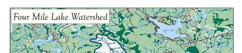
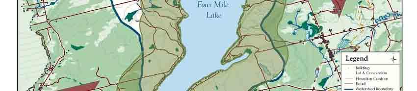
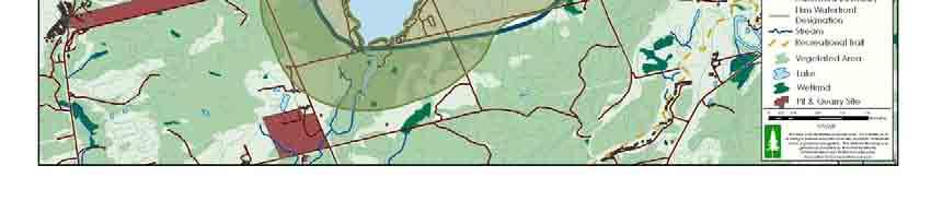
1 Attention: Mr. Rob Griffiths, Manager of Planning Development Services - Planning Division City of Kawartha Lakes 180 Kent St. W., Lindsay, ON, K9V 2Y6 September 6, 2006 Rob; DEDICATED TO THE PROTECTION AND PRESERVATION OF OUR LAKE President Brian Causton fourmiler@netscape.ca Vice-President James (Jim) Russell jimrussel@sympatico.ca Secretary / Treasurer Francis McQuaid fmcquaid@sympatico.ca Past President Robert (Bob) Fleischacker fly@stnhvn.ca Lake Steward Committee Brian Woods bwoods@interhop.net Chris Ostrovski ostrotpi@sympatico.ca Membership Mario Fortino mario.fortino@gmail.com (416) (705) Newsletter Rob Sylvester rsylvester@moneyconcepts.ca Director at Large Cliff Floyd cliff.floyd@sympatico.ca Please find attached a copy of the proposed Specific Lake Policies for Four Mile Lake. As we discussed previously, it is the desire of Four Mile Lake Association (FMLA) to have these included in the new official plan which is being adopted by the City of Kawartha Lakes. The Specific Lake Policies for Four Mile Lake have been developed following a review of the draft official plan and background material including the Michalski report (1986), the Environmental Report prepared by Bobby Briones and Erin Kelly (2001) and the Garter Lee Shoreline Environmental Studies in Support of OP Policies (August 2002). As you are aware, FMLA employed the expertise of Randy French (French Planning) in the development of these Policies. We have also attached 2 maps to be submitted in support of this policy; Four Mile Lake Surface Area Calculation; and the Four Mile Lake Watershed. The watershed map indicates the location of the proposed Waterfront Designation as described in the specific lake policies. These policies have been developed with a view to reflect the important values, issues and individual features of Four Mile Lake, and to protect the integrity and character of this shoreline residential community, and to preserve the environmental and social integrity of this very unique area of Kawartha Lakes. We would be pleased to arrange a suitable time to meet with you, Rob, to discuss our submission and clarify any questions or issues. We would appreciate your advice to us, when you have completed the revisions to the OP. I understand that you plan to complete your Final Draft of the OP in November, for presentation to Council in December. We have also attached a copy of a Report, prepared for FMLA by French Planning, as a general review of the City of Kawartha Lakes draft Official Plan (OP) dated June 22, As we discussed with you previously, we have attached, under separate cover these General Comments on the OP as they relate to Four Mile Lake and the Corben Creek Watershed. Once again, we are pleased to arrange an appropriate time to meet with you to discuss these General comments, confirm the intent of the Official Plan and its application to Four Mile Lake. Thank you for your continued attention to the issues and interests of Four Mile Lake, Rob. Please call me directly if you have any further information, or questions. Sincerely, Brian Causton, President FMLA Jim Russell, Vice President FMLA [67 Highland Crescent, Cambridge, ON, N1S 1M1]
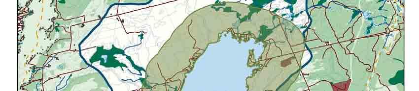
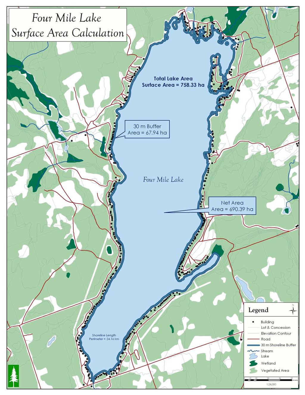
2 September 5, 2006 page 1 of 4 Four Mile Lake - Specific Lake Policy Four Mile Lake is a relatively shallow warm water lake (758 hectares) that is located in the sub watershed of Corben Creek. Four Mile Lake is a closed lake system that has no navigable access to or from the Trent River System or other lakes. The volume of water in Four Mile Lake has a very slow flushing rate of once in five years and this is directly influenced by its small drainage area. The current health of the lake and quality of life in the community is linked to the undeveloped rural character of the watershed. The lake is split by two significant geological land forms. The northern one-third of the lake is located on the Canadian Shield dominated by granite shorelines. The southern two thirds of the lake is located on the Carden plain, characterized with sedimentary limestone cliffs along the shoreline and consisting of unusual shale and other sedimentary rock formations located on an expansive plain dotted with scrub-like vegetation. The lakebed is primarily limestone, which provides a natural alkaline buffer to counter the damaging effects of acid rain. Four Mile Lake is a shoreline residential community that is at capacity for new recreational development and activities. The entire shoreline of Four Mile Lake has been heavily developed with over 450 single family residential dwellings. Existing dwellings have been constructed on lots with shoreline frontages of 30 m (100 ft) or less, and with shoreline setbacks of 15 m (50 ft). The frontage and area of the existing properties is, on average, less than half of the lot standards of the new official plan. There is no commercial or industrial development along the shoreline and the backlands are sparsely developed. According to past reports (Michalski, 1986, Briones/Kelly, 2001) about 2% of the shoreline remains undeveloped. There are only 2 significant portions of the lake that are undeveloped (i.e. north end and the bay on the southeast shore) and these areas must be preserved in their natural current state. The character and geology of the shorelines and surrounding watershed is unique and quite diverse and provide for a wide range fish and wildlife species and landscapes. However, it is recognized that this diversity is fragile and maybe threatened from any new development. The diversity of shoreline landforms includes limestone cliffs, exposed Canadian Shield, and wetlands. The diversity of the lake substrates include bedrock, limestone, gravel, sand and weedy areas. Due to this high diversity of landforms the watershed provides food, shelter and habitat for a wide variety of flora and fauna, including frogs, herons, loons and fish species, as well as several rare or endangered species such as black walnut trees, Butler's garter snake, Jefferson salamander, southern flying squirrel, and loggerhead shrike. Community members within the watershed and along the shoreline of Four Mile Lake enjoy good lake water quality and a high degree of peace, tranquility and privacy, and are concerned about the increased environmental and social stress to the lake due to any additional recreational development and activities. 1
3 September 5, 2006 page 2 of 4 Four Mile Lake is already over-saturated with recreational boating traffic. According to an analysis of the social carrying capacity of the lake based on 1 residential dwelling per 1.6 hectares of net surface area, the surface area of the lake can sustain a total of 431 residential dwellings. In addition, if we were to determine the total number of lots that the lake could sustain based on the official plans requirement of 60 m of lot frontage per residential lot for the entire shoreline length (24,160 m), the lake could only physically sustain 403 lots. Since there are already over 450 shoreline residential lots, Four Mile Lake is considered to be at capacity. For all of these reasons, Four Mile Lake is considered to be at-capacity for Residential Cluster and all commercial developments. In order to protect the integrity and character of this residential community, new shoreline and backlot residential development must occur in accordance with the following standards and new Residential Cluster or commercial development shall not permitted. The combined natural, social and physical values coupled with the relative segregation of the lake from other nearby bodies of water and lack of commercial/industrial development produces a residential lake community with a quality of life that is truly unique and worth preserving. 1. Four Mile Lake Objectives There is a strong community desire to maintain the unique status and the high quality of residential life on the lake. Some of the values that support this quality of life include: o good water quality, o safe living environment, o peaceful and quiet ambience, o unique Alvar areas and fish and wildlife habitat, o good fishing, and o the lack of commercial, industrial, and residential cluster and backlot development. The community of Four Mile Lake adopts the principles and objectives of the City of Kawartha Lakes Official Plan, and establishes the following objectives in order to protect and improve the health and diversity of the watershed, the lake and its shoreline areas: 1. To preserve the uniqueness of Four Mile Lake and its watershed. 2. To apply the Environment First principle when land use decisions are made and to err on the side of conservation when development and the environment are in conflict. Environment includes all natural, social and physical conditions. 3. To ensure that new or expanded development in the watershed does not alter the natural, social and physical elements that contribute to the uniqueness of the lake and the surrounding watershed. 2
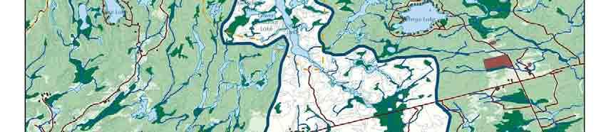
4 September 5, 2006 page 3 of 4 4. To maintain the current density of development and intensity of surface water activities on the lake. 2. Scope of Four Mile Lake Policies The scope of these policies applies to all lands with the Corben Creek Watershed and specifically to those lands within the waterfront designation as described and shown on the attached schedule. The Waterfront designation shall apply to all lands within 1 kilometre of the shoreline of Four Mile Lake. In addition, all development and major site alteration beyond the Four Mile Lake waterfront designation and within the subwatershed of Corben creek shall be consistent with the following policies, where applicable. 3. Specific Policies The following policies are intended to preserve the unique character of Four Mile Lake and are to be read in conjunction with entire CoKL Official Plan. In situations where the policies are in conflict, the more restrictive policies are to be applied. Four Mile Lake Waterfront Designation a) Permitted Uses: Single family residential dwellings, and accessory uses and structures Existing commercial, rural and industrial uses b) Specific Policies: 1. All new shoreline residential lots shall require a minimum lot frontage of 60 m on Four Mile Lake and a lot area of 0.4 hectares. No new residential infilling as per Policy will be permitted on smaller sized lots. New shoreline residential development shall only be in the form of single family dwellings on separate lots that directly front on Four Mile Lake. New residential cluster developments on the shoreline will not be permitted. 2. New single family residential dwellings will be permitted on backlots (i.e. lands with no lake frontage) on existing lots of record that have a minimum lot frontage of 60 m on a publicly maintained road and have a lot area of 0.4 ha. All development shall have a minimum setback from the road of 30 m. New backlots may not be created except to separate two existing residential dwellings. Residential cluster development on backlots with access to the lake through private or publicly owned lands will not be permitted. 3. New commercial, industrial or rural developments (e.g. resorts, marinas, trailer parks, golf courses, pits and quarries, agricultural operations etc.) or expansions to existing operations shall not be permitted. 3
5 September 5, 2006 page 4 of 4 4. Recreational trailers and vehicles may only be used on a temporary basis when a building permit for a main residential building has been issued. 5. Home industries are not a permitted use in the Waterfront Designation. Home occupations are a permitted use in the waterfront designation. New Bed and Breakfast operations may be considered provided they meet all requirements for home occupations and do not exceed 2 guest rooms per dwelling and are located on lots with a minimum lot frontage of 60 m of lot frontage and a minimum lot area of 0.4 ha. 6. Municipally owned waterfront lands should remain in public ownership and not be further improved to provide increased access to the lake. These publicly owned lands should not be used to provide primary lake access for new commercial, industrial, recreational or backlot/cluster development activities. Public lands that are currently used to gain access to the lake will be maintained in their current state with existing controls (e.g. the municipally operated gate at the access boat ramp on east-side Hillside Drive will be maintained as is according to Somerville by-law #95-20). Development within the Corben Creek Watershed The following policies apply to development and site alteration within the watershed: 7. No aggregate/quarrying development within 1000 m of Four Mile Lake. Aggregate/quarrying sites outside of this 1000 m area will require specific site rehabilitation and an Environmental Assessment Report (paid by the proponent) to ensure no direct or indirect impacts on Four Mile Lake s natural, social and physical character. Such a report will meet all government guidelines, and be prepared by a qualified 3 rd party. 8. Representatives from the Four Mile Lake Association will be included in any aggregate advisory committee to address proposals within the watershed of Corben Creek. 9. Public notice of any planning application (i.e. official plan amendment, zoning by-law amendment and minor variances) occurring within the watershed of Corben Creek will be sent to the Four Mile Lake Association. 4
6
7
Town of Huntsville Official Plan Section 9 Rural Area Page 104
 Section 9 Rural Area Page 104 9 RURAL AREA 9.1 Definition and Function Location Rural Settlements 9.1.1 The Rural Area includes those lands located outside any other land use designation identified in
Regional Watersheds Advisory Board. September 20, 2017
 Regional Watersheds Advisory Board September 20, 2017 Agenda Definitions Policy Framework (general overview) Watershed Planning Regulations (in detail) 2 Definitions Policy - A statement of intent Land
OFFICIAL PLAN. Office Consolidation
 OFFICIAL PLAN Office Consolidation As approved by the Ministry of Municipal Affairs and Housing (December 17, 2012) and Ontario Municipal Board (August 4, 2016) and As amended by Official Plan Amendments
Aggregate Extraction, Rehabilitation & Current Research in Ontario. Muskoka Watershed Council - March 20, 2015
 Aggregate Extraction, Rehabilitation & Current Research in Ontario Aggregates 101 Production Statistics Legislation Rehabilitation Current Research What the future holds Questions Geology of Aggregates
OFFICIAL PLAN FOR THE MUNICIPALITY OF MAGNETAWAN
 OFFICIAL PLAN FOR THE MUNICIPALITY OF MAGNETAWAN Prepared by July 24, 2002 May 16, 2005 and June 14, 2005 With Jim s Notes on Modifications Modifications provided by MMAH on May 10, 2005 and June 8, 2005
H ollow R iver. Stewardship Works! S ubwatershed. Grades. Land Water Wetlands Biodiversity. Not Stressed Not Stressed Not Stressed Vulnerable
 s H ollow R iver Land Water Wetlands Biodiversity S ubwatershed T he Hollow River Subwatershed is 40,863 hectares in size and lies predominantly in the Township of Algonquin Highlands in Haliburton County.
City of Mississauga Environmental Impact Studies Terms of Reference 2002
 City of Mississauga Environmental Impact Studies Terms of Reference 2002 1.0 INTRODUCTION To ensure in so far as possible, both private and public developments are consistent with Natural Heritage and
Sustainable Natural Environment Fish Habitat
 Town of Huntsville Official Plan Review - POLICY BACKGROUND PAPER Sustainable Natural Environment Fish Habitat BACKGROUND: Lakes, rivers, streams, ponds and many wetlands provide fish habitat. Intermittent
District of Muskoka Planning and Economic Development Department. Lake of Bays Association Executive Committee
 Date: November 10, 2017 To: From: C.C. District of Muskoka Planning and Economic Development Department Lake of Bays Association Executive Committee Lake of Bays Association Board of Directors Township
Strength. Performance. Passion. Paris Pit CAP. September 25, 2012
 Strength. Performance. Passion. Paris Pit CAP September 25, 2012 2012 Holcim 2012 (Canada) Holcim (Canada) Inc. Inc. Agenda Introductions Minutes from Last Meeting Dufferin Paris Pit - General Update Holcim
Minnesota s Alternative Shoreland Management Standards
 Minnesota s Shoreland Management Standards In summary, the Standards include, but are not limited to: Multiple shoreland lake classifications on a single lake, for example, a natural environment bay of
APC REPORT. TO: APC C Members File No: DP PL
 APC REPORT TO: APC C Members File No: DP725-137 PL20180000028 FROM: Erica Hartling Development Services Assistant Date: March 16, 2018 SUBJECT: Electoral Area C: Development Permit 725-137 SHORT SUMMARY:
IMPACT ON LAND. 1. Will there be an effect as a result of a physical change to project site? Yes No
 Part 2 Project s Can Be IMPACT ON LAND 1. Will there be an effect as a result of a physical change to project site? Any construction on slopes of 15% or greater (15-foot rise per 100 feet of length) or
Waterfront and Rural Background Policy Paper
 Waterfront and Rural Background Policy Paper Executive Summary In support of the preparation of the City s new Official Plan, this background report provides a review of the existing policy context for
Article II Definitions Section 200 Interpretation II Definitions II-1
 CHAPTER 27 ZONING TABLE OF CONTENTS Page Article I Introductory Provisions Section 100 Short Title I-1 101 Purpose I-1 102 Interpretation I-1 103 Scope I-1 104 Conflict I-2 105 Validity I-2 106 Repealer
Official Plans. Zoning By-laws. Site Plan Control Development Approvals and Agreements. Figure 28 Municipal Planning Tools
 Section 7 The purpose of this section is to identify known future growth areas in the Town of Huntsville and describe the municipal planning documents and regulations that apply to Lake Vernon in order
3.0 Natural Resource Management Policies. 3.4 Resource Extraction Policies
 3.0 Natural Resource Management Policies 3.4.1 Mineral Aggregates INTRODUCTION Oxford County is characterized by significant reserves of mineral aggregates, including bedrock-derived crushed stone and
Draft Official Plan presented to Committee of the Whole on November 24, 2017 Held an information session with local municipal staff and agency staff
 Draft Official Plan presented to Committee of the Whole on November 24, 2017 Held an information session with local municipal staff and agency staff at the beginning of November to highlight the proposed
Maine s Land Use Regulations and Erosion Control Techniques
 Maine s Land Use Regulations and Erosion Control Techniques Protecting Maine s Air, Land and Water Colin Clark 441-7419 colin.a.clark@maine.gov Tom Gilbert 441-8031 thomas.gilbert@maine.gov Jim Rodrigue
COMMUNITY INDUSTRIAL ZONE
 By-law Discussion Paper # 18 COMMUNITY INDUSTRIAL ZONE Meeting Date: November 22, 2001 Official Plan Intent To direct most industrial uses to the communities, unless they are more appropriate in another
Environmental Impact Statement for the Slave Falls Tramway Conversion Project
 Environmental Impact Statement for the Slave Falls Tramway Conversion Project Prepared for Submitted by 41844.101 March 2008 ENVIRONMENTAL IMPACT STATEMENT FOR THE SLAVE FALLS TRAMWAY CONVERSION PROJECT
ATTACHMENT 2A- Issues Tentatively Resolved Decisions from the Board of Supervisors Hearing on September 11, 2007
 1. Introduction (on pg 1-15) Add the following goal: A Community safe from climate change. Marin will be a leader in averting and adapting to aspects of climate change. 2. Biological Resources 2.A. Richardson
FULL ENVIRONMENTAL ASSESSMENT FORM (FEAF) PART 1 PROJECT INFORMATION
 PART 1 PROJECT INFORMATION") FULL ENVIRONMENTAL ASSESSMENT FORM (FEAF) PART 1 PROJECT INFORMATION (prepared by project sponsor/applicant) NOTE: This document is designed to assist in determining whether proposed action may have a
FULL ENVIRONMENTAL ASSESSMENT FORM (FEAF) PART 1 PROJECT INFORMATION (prepared by project sponsor/applicant) NOTE: This document is designed to assist in determining whether proposed action may have a
March 20, Mr. Steven Dodd, Executive Secretary Dorchester County Board of Zoning Appeals County Office Building P.O. Box 307 Cambridge, MD 21613
 March 20, 2008 Mr. Steven Dodd, Executive Secretary Dorchester County Board of Zoning Appeals County Office Building P.O. Box 307 Cambridge, MD 21613 RE: Dorchester County Board of Zoning Appeals Case
How Much Habitat is Enough?
 How Much Habitat is Enough? Canadian Wildlife Service 2017 Third Edition Page 2 April 19, 2017 Grasslands Forest Wetlands Riparian & Watershed Page 3 April 19, 2017 Significant impairment in stream At
6 January 12, 2011 Public Hearing APPLICANT & PROPERTY OWNER: ROBERT L. NELSON & BRENDA N. GRAY T/A WEST LANDING MARINA
 6 January 12, 2011 Public Hearing APPLICANT & PROPERTY OWNER: ROBERT L. NELSON & BRENDA N. GRAY T/A WEST LANDING MARINA STAFF PLANNER: Carolyn A.K. Smith REQUEST: Modification of Conditions of a Conditional
WQMP AMENDMENT REVIEW CHECKLIST
 State of New Jersey Highlands Water Protection and Planning Council 100 North Road (Route 513) Chester, New Jersey 07930-2322 (908) 879-6737 (908) 879-4205 (fax) www.highlands.state.nj.us WQMP AMENDMENT
B ig E ast R iver. Stewardship Works! S ubwatershed. Grades. Land Water Wetlands Biodiversity. Not Stressed Not Stressed Not Stressed Vulnerable
 s B ig E ast R iver Land Water Wetlands Biodiversity S ubwatershed T he Big East River Subwatershed is 64,699 hectares in area. Major lakes in the subwatershed include Bella Lake (3.45 km2) and Rebecca
Relevant Excerpts from Electoral Area C Official Community Plan Bylaw No. 725
 Relevant Excerpts from Electoral Area C Official Community Plan Bylaw No. 725 (See Bylaw No. 725 for all policies) Section 2.3 Shoreline Environment Section 3.7 Foreshore Water Section 12.2 Foreshore and
Whatcom County Code Chapter Critical Areas Regulations: Wetlands, Streams, and Wildlife
 Whatcom County Code Chapter 16.16 Critical Areas Regulations: Wetlands, Streams, and Wildlife August 20, 2014 Wayne Fitch Natural Resources Supervisor Erin Page Natural Resources Planner III CAO Basics
Request for Decision STAFF REPORT. Recommendation. Presented To: Planning Committee. Presented: Tuesday, Jan 11, 2011
 Request for Decision Application for Rezoning in order to permit a permanent waterfront residential use in a seasonal zone on Makada Lake, 110 Clark Road, Lively - Margaret & James Johnson Presented To:
September Environmental Impact Statement Eufaula Lake Visual Resources Assessment Technical Report
 September 2012 Environmental Impact Statement Eufaula Lake Visual Resources Assessment Technical Report Table of Contents Acronyms... v Chapter 1 Executive Summary... 1 1 1.1 Introduction... 1 1 1.2 Methods
STAFF REPORT WASHINGTON STATE PARKS AND RECREATION COMMISSION COVERED SHELTERS AND BIKE RACKS
 STAFF REPORT WASHINGTON STATE PARKS AND RECREATION COMMISSION COVERED SHELTERS AND BIKE RACKS TO: Douglas County Hearing Examiner FROM: Douglas County Land Services Staff RE: SP-2019-02 DATE: April 8,
Provincial Policy Statement 2014 Training Aid
 This job aid has been developed for education and training purposes as a high-level summary of the policy changes in the PPS 2014. It should not be relied upon as a substitute for specialized legal or
Agriculture and farm related businesses and industries are important economic generators for the local and regional community.
 SECTION 3: LAND USE POLICIES - AGRICULTURE Lands designated Agriculture are areas with highly valued soils in accordance with the CLI mapping and therefore have potential for agricultural production, areas
ELK RAPIDS TOWNSHIP WATER QUALITY ACTION PLAN
 ELK RAPIDS TOWNSHIP WATER QUALITY ACTION PLAN Elk-River-Chain-of-Lakes Gaps Analysis Project The Watershed Center Grand Traverse Bay Tip of the Mitt Watershed Council Michigan Department of Natural Resources
Shoreland Rules Revision Project Using GIS in North-Central Minnesota
 Shoreland Rules Revision Project Using GIS in North-Central Minnesota Andrew J. Williquett Department of Resource Analysis, Saint Mary s University of Minnesota, Minneapolis, MN 55404 Keywords: GIS, docks,
SECTION 3.322: NESKOWIN LOW DENSITY RESIDENTIAL ZONE (NeskR-1)
") SECTION 3.322: NESKOWIN LOW DENSITY RESIDENTIAL ZONE (NeskR-1) (1) PURPOSE: The purpose of the NeskR-1 zone is to designate areas for lowdensity single-family residential development and other, compatible,
SECTION 3.322: NESKOWIN LOW DENSITY RESIDENTIAL ZONE (NeskR-1) (1) PURPOSE: The purpose of the NeskR-1 zone is to designate areas for lowdensity single-family residential development and other, compatible,
SUBJECT: WASHINGTON DEPARTMENT OF FISH AND WILDLIFE COMMENTS ON THE CITY OF MOSES LAKE DRAFT SHORELINE MASTER PROGRAM
 State of Washington Department of Fish and Wildlife Mailing Address: 1550 Alder St. NW, Ephrata, WA 98823 Main Office Location: Natural Resources Building, 1111 Washington St. SE Olympia WA July 9, 2014
STATE ENVIRONMENTAL POLICY ACT DETERMINATION OF NONSIGNIFICANCE - REVISED
 n+ Skamania County Community Development Department Building/Fire Marshal Environmental Health Planning Skamania County Courthouse Annex Post Office Box 1009 Stevenson, Washington 98648 Phone: 509-427-3900
RS-1 District Schedule
 District Schedule 1 Intent The intent of this Schedule is generally to maintain the single-family residential character of the District, but also to permit conditionally one-family dwellings with secondary
RS-1 District Schedule
 District Schedule 1 Intent The intent of this Schedule is generally to maintain the single-family residential character of the District, but also to permit conditionally one-family dwellings with secondary
Plan Review Background Paper Background Paper Number: 19 Planning & Development Department Date: September 2015
 Plan Review Background Paper Background Paper Number: 19 Planning & Development Department Date: September 2015 Environment Background East Hants is fortunate to enjoy the benefits of many natural resources
Errata sheet for the Connecticut General Permits May 2, 2017
 Errata sheet for the Connecticut General Permits May 2, 2017 The Corps of Engineers, New England District, has compiled this list of corrections and clarifications for the Connecticut General Permits that
Natural Systems Planning Primer
 Natural Systems Planning Primer Lise.Guevremont@ottawa.ca Amy.Macpherson@ottawa.ca Land Use and Natural Systems Unit Planning and Growth Management November 2015 1 Welcome Policy Framework Development
CLEARWATER TOWNSHIP WATER QUALITY ACTION PLAN
 CLEARWATER TOWNSHIP WATER QUALITY ACTION PLAN Elk-River-Chain-of-Lakes Gaps Analysis Project The Watershed Center Grand Traverse Bay Michigan Department of Environmental Quality July 2011 Purpose The Grand
Name of Action: Name of Lead Agency: Name and Title of Responsible Officer in Lead Agency: Signature of Responsible Officer in Lead Agency:
 CITY OF ITHACA FULL ENVIRONMENTAL ASSESSMENT FORM (FEAF) Purpose: This Full Environmental Assessment Form (FEAF) is designed to help applicants and agencies determine, in an orderly manner, whether a project
Environmental Resource Inventories. What are ERIs? Significance of information How to use them
 Environmental Resource Inventories What are ERIs? Significance of information How to use them Environmental Resource Inventory - ERI Compiled by the environmental commission Information about the natural
SUSTAINABLE COMMUNITIES OFFICIAL PLAN Local priorities for a sustainable County
 SUSTAINABLE COMMUNITIES OFFICIAL PLAN Local priorities for a sustainable County Adopted June 27, 2012 Prepared by LANARK COUNTY Sustainable Communities Official Plan Adopted - June 27, 2012 TABLE OF CONTENTS
Kootenai County Building & Planning Department
 Kootenai County Building & Planning Department Site Disturbance Ordinance Amendment Proposal STAFF DRAFT 12 11-2-4: DEFINITIONS: MECHANICAL GROUND DISTURBANCE: The use of mechanized and/or mechanically
Public Notice. US Army Corps of Engineers Memphis District. NOTICE DATE: September 25, EXPIRATION DATE: October 25, 2018
 US Army Corps of Engineers Memphis District FILE NUMBER: MVM 2018-249 (RDM) Public Notice NOTICE DATE: September 25, 2018 Attn: Postmaster, Please Post Until EXPIRATION DATE: October 25, 2018 Public Notice
DRAFT - CLALLAM COUNTY SHORELINE MASTER PROGRAM (SMP)
") Planning Commission Review Draft August 2014 DRAFT - CLALLAM COUNTY SHORELINE MASTER PROGRAM (SMP) Note to Reviewers: The Clallam County Shoreline Master Program (SMP) was adopted in 1976, and last amended
Planning Commission Review Draft August 2014 DRAFT - CLALLAM COUNTY SHORELINE MASTER PROGRAM (SMP) Note to Reviewers: The Clallam County Shoreline Master Program (SMP) was adopted in 1976, and last amended
Town of Windham Land Use Ordinance Table of Contents
 Town of Windham Land Use Ordinance Table of Contents SECTION 100 GENERAL 101 Title... 1-1 102 Purpose... 1-1 103 Severability Clause... 1-1 104 Conflicts... 1-2 105 Conformance Required... 1-2 106 Rules
Town of Caledon Official Plan Chapter 5 Town Structure & Land Use Policies
 5.11 MINERAL RESOURCES The role of the Town of Caledon in the hierarchy of Provincial, Regional, and local aggregate resource planning, is to establish comprehensive mineral aggregate resource policies
ENVIRONMENT ACT TERMS OF REFERENCE NOVA SCOTIA DEPARTMENT OF TRANSPORTATION AND PUBLIC WORKS. Beaver Bank Bypass
 ENVIRONMENT ACT TERMS OF REFERENCE NOVA SCOTIA DEPARTMENT OF TRANSPORTATION AND PUBLIC WORKS Beaver Bank Bypass Highway 101 to the Beaver Bank Road Halifax County, NS NOVA SCOTIA DEPARTMENT OF THE ENVIRONMENT
APPLICATION NUMBER A REQUEST FOR
 APPLICATION NUMBER 5483 A REQUEST FOR USE AND PARKING SURFACE VARIANCES TO ALLOW A MARINE CONTRACTOR S STORAGE YARD WITH AGGREGATE PARKING AND LAY-DOWN YARD SURFACES IN AN R-1, SINGLE-FAMILY RESIDENTIAL
RS-5 District Schedule
 District Schedule 1 Intent The intent of this Schedule is generally to maintain the existing single-family residential character of the District by encouraging new development that is compatible with the
CHAPTER 7: SHORELINE DESIGNATIONS
 CHAPTER 7: SHORELINE S Introduction Shoreline Designations are intended to encourage uses and activities that will protect or enhance the present or desired character of a shoreline and allow appropriate
Preliminary Decision Memo 2017 BPA Utility Corridor Maintenance and Danger Tree Project
 Preliminary Decision Memo 2017 BPA Utility Corridor Maintenance and Danger Tree Project USDA Forest Service Crescent Ranger District, Deschutes National Forest Klamath County, Oregon The Crescent Ranger
ADDENDUM TO THE CITY OF LAKEPORT GENERAL PLAN EIR
 ADDENDUM TO THE CITY OF LAKEPORT GENERAL PLAN EIR OCTOBER 24, 2014 Prepared for: City of Lakeport Community Development Department 225 Park Street Lakeport, CA 95453 Prepared by: De Novo Planning Group
CHAPTER 8: ENVIRONMENTAL MANAGEMENT POLICIES
 TOWNSHIP OF WELLESLEY OFFICIAL PLAN page 74 of 133 CHAPTER 8: ENVIRONMENTAL MANAGEMENT POLICIES Jurisdiction over environmental matters is divided among different levels of government. Effective environmental
WATERSHED. Report Card Nottawasaga Valley
 Nottawasaga Valley WATERSHED Report Card 2013 The Nottawasaga Valley Conservation Authority has prepared this report card as a summary on the state of our forests, wetlands, surface water, and ground water
PRESENTED: March 27th th, 2007 FILE: Bylaw No FROM: Planning Department
 DISTRICT OF SQUAMISH REPORT TO: Council FOR: Regular PRESENTED: March 27th th, 2007 FILE: 2005-21 Bylaw No. 1873 FROM: Planning Department SUBJECT: Bylaw No. 1873 Logger s Lane Small Lot Residential Recommendation:
Chapter 516 Shoreland Districts
 Chapter 516 Shoreland Districts 516.01 Statutory Authorization The State of Minnesota in Minnesota Statutes, Chapter 103F, has defined shoreland areas and described limitations on uses and locations of
SUMMARY OF MAJOR POLICY IMPLEMENTATION TOPICS From 2016 COUNTY Comprehensive Plan
 SUMMARY OF MAJOR POLICY IMPLEMENTATION TOPICS From 2016 COUNTY Comprehensive Plan A checkmark means that implementing code amendments have been drafted or are in progress as of November 1, 2016. Evaluate
PLANNING RATIONALE MACLEOD III AND V QUARRIES
 PLANNING RATIONALE MACLEOD III AND V QUARRIES Project No.: OCP-16-0280 Prepared for: Cornwall Gravel Company Ltd. 390 Eleventh Street West Cornwall, Ontario K6J 3B2 Prepared by: McIntosh Perry Consulting
Errata sheet for the Connecticut General Permits March 26, 2019
 Errata sheet for the Connecticut General Permits March 26, 2019 The Corps of Engineers, New England District, has compiled this list of corrections and clarifications for the Connecticut General Permits
The Corporation of the City of Kawartha Lakes Minutes Planning Advisory Committee Meeting
 The Corporation of the City of Kawartha Lakes Minutes Planning Advisory Committee Meeting PC2018-09 Wednesday, 1:00 P.M. Victoria Room City Hall 26 Francis Street, Lindsay, Ontario K9V 5R8 Members: Mayor
Minimum Area 7. Minimum Width. 5 Acres 100 Ft None 6 None 6 None 6. 1 Acre 150 Ft 20 Ft 20 Ft 4 35 Ft. 1 Acre 100 Ft 20 Ft 20 Ft 4 35 Ft
 Table 4.0 Zoning District Lot Size Minimum Area 7 Minimum Width Setbacks Front Yard: Per Section 2.08 Waterfront: Per Shoreland Zoning Minimum Side Yard Minimum Rear Yard Maximum Building Height 6 Conservancy
COMMUNITY SUPPORT FOR ADOPTING WOODLAND CONSERVATION REGULATIONS EXAMPLE OF A WOODLAND CONSERVATION ORDINANCE STATEMENT OF PURPOSE:
 EXAMPLE OF A WOODLAND CONSERVATION ORDINANCE STATEMENT OF PURPOSE: To preserve wooded corridors that connect large tracts of forests to act as wildlife corridors, encouraging species diversity by providing
Sturgeon Lake Community Advisory Panel Meeting. Minutes. (Kawartha Lake Stewards Association) (City of Kawartha Lakes Agricultural Advisory Committee)
 (City of Kawartha Lakes Agricultural Advisory Committee)") Wednesday, November 10 th, 2010 10:00 a.m. 12:00 p.m. Kawartha Conservation Administrative Centre d d Sturgeon Lake Community Advisory Panel Meeting Minutes Date: November 10, 2010, 10:00 a.m. 12:00 p.m.
Wednesday, November 10 th, 2010 10:00 a.m. 12:00 p.m. Kawartha Conservation Administrative Centre d d Sturgeon Lake Community Advisory Panel Meeting Minutes Date: November 10, 2010, 10:00 a.m. 12:00 p.m.
Conservation. Our Natural Resources. Introduction. San Rafael s Habitats
 Conservation Our Natural Resources Introduction Conservation helps prevent the wasteful destruction and neglect of San Rafael's natural resources, particularly scarce resources. The City recognizes that
PLANNED UNIT DEVELOPMENT & PLANNING APPROVAL STAFF REPORT Date: February 7, 2013
 PLANNED UNIT DEVELOPMENT & PLANNING APPROVAL STAFF REPORT Date: February 7, 2013 NAME LOCATION MAWSS Shelton Beach Road East side of Shelton Beach Road Extension, 2/10± mile North of Moffett Road CITY
2014 Municipal Water Policy on Stormwater. Convention Policy Paper
 2014 Municipal Water on Stormwater Convention Paper Contents 1. Background... 3 Objective... 3 2. Statements... 4 Stormwater Management Guidelines for the Province of Alberta... 4 Municipal Government
Teri Camery, Senior Planner Community Development Department. Deletion of CBJ Code (a)(2 and 3), Eagle Nest Buffers
(2 and 3), Eagle Nest Buffers") DATE: August 1, 2017 TO: FROM: Planning Commission Teri Camery, Senior Planner Community Development Department FILE NO.: AME2016 0019 PROPOSAL: APPLICANT: LOCATION: Deletion of CBJ Code 49.70.310(a)(2
DATE: August 1, 2017 TO: FROM: Planning Commission Teri Camery, Senior Planner Community Development Department FILE NO.: AME2016 0019 PROPOSAL: APPLICANT: LOCATION: Deletion of CBJ Code 49.70.310(a)(2
a. The following regulations shall apply to all guest ranches:
 SECTION 15 GENERAL DEVELOPMENT STANDARDS 15.1 Guest Ranches. a. The following regulations shall apply to all guest ranches: (1) Individual guest ranch quarters shall not contain Kitchen or cooking facilities.
DEKALB COUNTY STORMWATER MANAGEMENT PLAN PHASE 2
 DEKALB COUNTY STORMWATER MANAGEMENT PLAN PHASE 2 Introduction DeKalb County, Illinois, located approximately 50 miles west of Lake Michigan, is rectangular in shape, with a north/south dimension of 36
The Corporation of the City of Kenora. By-law Number A By-law to Amend the Comprehensive Zoning By-Law Number , as amended
 The Corporation of the City of Kenora By-law Number 15-2012 A By-law to Amend the Comprehensive Zoning By-Law Number 160-2010, as amended Whereas the Council of the Corporation of the City of Kenora passed
Overview and key environmental issues
 Blue Mountains Draft Local Environmental Plan 2013 1 Information Sheet 4 Overview and key environmental issues Use this document in conjunction with Information Sheet 5: SUBMISSION WRITING GUIDE AND SUMMARY
STANDARDS TO ADDRESS THE ENVIRONMENTAL FACTORS
 94-412 SACO RIVER CORRIDOR COMMISSION Chapter 103: STANDARDS TO ADDRESS THE ENVIRONMENTAL FACTORS SUMMARY: All projects approved must show no unreasonable a) degradation of water and water quality, b)
Prepared For: Prepared By:
 NORTH BAY-MATTAWA CONSERVATION AUTHORITY WETLANDS POLICY DRAFT Prepared For: North Bay-Mattawa Conservation Authority 15 Janey Avenue North Bay ON P1C 1N1 Prepared By: Stantec Consulting Ltd. 49 Frederick
Public Notice. Navigation Section Notice Date: May 23, 2018 PO Box 3755 Expiration Date: June 21, 2018
 Public Notice Navigation Section Notice Date: May 23, 2018 PO Box 3755 Expiration Date: June 21, 2018 Seattle, WA 98124-3755 Reference: PMP-18-15 ATTN: John Pell (OD-TS-NS) or Joanne Gardiner (PMP-E) US
Carp Creek 2013 Summary Report
 Monitoring Activity in the Carp River Watershed In 2012, Mississippi Valley Conservation Authority (MVCA) worked with Friends of the Carp River (FCR) on a preliminary assessment of the Carp River. This
SEDs. Comments from Skokomish Tribe
 Contents SEDs... 1 Comments from Skokomish Tribe... 1 Comments on Lake Cushman... 2 Page 50 table 17.50.040-A, Shoreline stabilization... 3 Page 57 Section A #8, Monitoring... 3 Page 69 Section G #1, Archaeological
Model Riparian Buffer Ordinance.
 Model Riparian Buffer Ordinance. This is a sample riparian buffer ordinance written as an amendment to an existing zoning ordinance. This ordinance complies with the state minimum standards for river corridor
SUBURBAN RESIDENTIAL. QLDC PROPOSED DISTRICT PLAN [PART THREE] DECISIONS VERSION 7 lower density SUBURBAN residential
![SUBURBAN RESIDENTIAL. QLDC PROPOSED DISTRICT PLAN [PART THREE] DECISIONS VERSION 7 lower density SUBURBAN residential](/thumbs/79/80169357.jpg "SUBURBAN RESIDENTIAL. QLDC PROPOSED DISTRICT PLAN [PART THREE] DECISIONS VERSION 7 lower density SUBURBAN residential") 7 LOWER DENSITY SUBURBAN RESIDENTIAL 7.1 Zone Purpose The Lower Density Suburban Residential Zone is the largest residential zone in the District. The District Plan includes such zoning that is within
7 LOWER DENSITY SUBURBAN RESIDENTIAL 7.1 Zone Purpose The Lower Density Suburban Residential Zone is the largest residential zone in the District. The District Plan includes such zoning that is within
DESIGN SHEET Wastewater Treatment Plant. Mauritius. Design Sheet. Wastewater Treatment Plant. Revised 08 October Ministry of Housing and Lands
 Mauritius Design Sheet Wastewater Treatment Plant Revised 08 October 2014 Ministry of Housing and Lands Design Sheet Wastewater Treatment plant Ministry of Housing and Lands Contents: Page 1.0 Introduction
Principles of the Estero Bay Agency on Bay Management Revised May 13, 2002
 Principles of the Estero Bay Agency on Bay Management Revised May 13, 2002 The Estero Bay Agency on Bay Management (ABM) is a non-regulatory body whose directive is to make comments and recommendations
The Municipal Land Use Law, at N.J.S.A. 40:55D-89, includes the following statement relative to the periodic examination of a municipal Master Plan:
 2002 Periodic Reexamination Report of the Master Plan and Development Regulations for Lebanon Township, Hunterdon County, New Jersey May 16, 2002 (Adopted as revised on May 21, 2002) The Municipal Land
RT-10 and RT-10N Districts Schedule
 Districts Schedule 1 Intent The intent of this Schedule is to encourage development of multiple small houses and duplexes on large lots and assembled sites, while continuing to permit lower intensity development
CITY POLICY POLICY NUMBER: C531 REFERENCE: ADOPTED BY: City Council Council July 2007 SUPERSEDES: Policy C467
 CITY POLICY REFERENCE: ADOPTED BY: City Council Council 1995 07 25 17 July 2007 SUPERSEDES: Policy C467 PREPARED BY: Office of Natural Areas DATE: 5 June 2007 Policy Statement: Since Edmonton was settled
Shoreland Protection Innovative Model Ordinance
 Shoreland Protection Innovative Model Ordinance Southern New Hampshire Planning Commission September 14, 2007 Innovative Land Use Guide Training Presented By: Jack Munn, Senior Planner, SNHPC For Questions
CESAM-RD-N January 21, 2016 PUBLIC NOTICE NO. SAM JSC
 DEPARTMENT OF THE ARMY MOBILE DISTRICT, CORPS OF ENGINEERS MONTGOMERY FIELD OFFICE 605 MAPLE STREET BUIKDING 1429, ROOM 105 MAXWELL AIR FORCE BASE, ALABAMA 36112 PUBLIC NOTICE NO. JOINT PUBLIC NOTICE U.S.
Town of Sumner 2025 Comprehensive Plan
 2016 Update to: Planning Report 2025 Comprehensive Plan Jefferson County, Wisconsin October 2002 1 Page 1-4 Census Count Table 1-1 Population Trends 1970 2000; updated with 2010 Data # Change 1970 1980
CATEGORY a protection of the natural environment, its ecosystems and biodiversity.
 29. ENVIRONMENTAL DEVELOPMENT PERMIT AREA CATEGORY a protection of the natural environment, its ecosystems and biodiversity. The requirement to obtain an environmental development permit is cited in Section
Cannon River One Watershed, One Plan. POLICY COMMITTEE MEETING January 10, 2018 Rice County Government Center Faribault, MN
 Cannon River One, One Plan POLICY COMMITTEE MEETING January 10, 2018 Rice County Government Center Faribault, MN TASK Task 1. Aggregate Existing Physical & Spatial Data 1A. Create project maps 1B. Meeting
WELCOME. RM of Big River Official Community Plan & Zoning Bylaw. The purpose of this Open House is: What is a Zoning Bylaw? Background information:
 WELCOME The purpose of this Open House is: To present highlights of the draft versions of proposed new planning bylaws (Official Community Plan and Zoning Bylaw) for the Rural Municipality of Big River
APPENDIX A REVIEW OF NATURAL HERITAGE SYSTEM POLICIES AND MAPS
 APPENDIX A REVIEW OF NATURAL HERITAGE SYSTEM POLICIES AND MAPS MARCH 16, 2017 TABLE OF CONTENTS A1. NHS POLICY IN THE ROP... 3 A2. RNHS POLICY IN THE ROP... 3 A3. CONSTRAINTS TO DEVELOPMENT IN THE GREENBELT
9633 Marr Hwy, Brooklyn, MI 49230
 Lenawee County Gravel Pit 9633 Marr Hwy, Brooklyn, MI 49230 Listing ID: 29834763 Status: Active Property Type: Vacant Land For Sale Possible Uses: Agricultural, Residential (Single Family) Gross Land Area:
Decision Notice and Finding of No Significant Impact
 Decision Notice and Finding of No Significant Impact Gold Lake Bog Research Natural Area Boundary Adjustment and Nonsignificant Forest Plan Amendment #53 USDA Forest Service Middle Fork Ranger District,