Water Availability and Use in the Great Lakes Region
|
|
|
- Gavin Mathews
- 6 years ago
- Views:
Transcription

1 Water Availability and Use in the Great Lakes Region Howard W. Reeves, USGS Michigan Water Science Center Michigan Chapter Soil and Water Conservation Society Seminar A Matter of Balance: Energy, Water and Working Lands March 7, 2012
2 Hossain, Faisal; Niyogi, Dev; Adegoke, Jimmy; Kallos, George; and Pielke, Roger, 2011, Making sense of the water resources that will be available for future use: EOS, Transactions American Geophysical Union, v. 92, no. 17, pg. 144, doi: /2011EO170005

3 Based on observations Understand and account for uncertainty

4 Water use in the U.S. Hutson, S.S., Barber, N.L., Kenny, J.F., Linsey, K.S., Lumia, D.S., and Maupin, M.A., 2004, Estimated use of water in the United States in 2000: Reston, Va., U.S. Geological Survey Circular 1268, 46 p.

5 Hutson and others, 2004.

6 Hutson and others, 2004.

7 Maupin, M.A., and Barber, N.L., 2005, Estimated withdrawals from principal aquifers in the United States, 2000: U.S.Geological Survey Circular 1279, 46 p.

8 Maupin and Barber, 2005.

9 Regional Groundwater Availability Studies Status of groundwater resources for the nation Response of groundwater systems to development Potential response to future development and climate change
10 USGS Groundwater Resources Program regional groundwater availability studies (

11 Faunt, C.C. ed., 2009, Groundwater Availability of the Central Valley Aquifer: U.S. Geological Survey Professional Paper 1766, 225 p. Available at

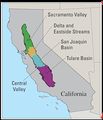
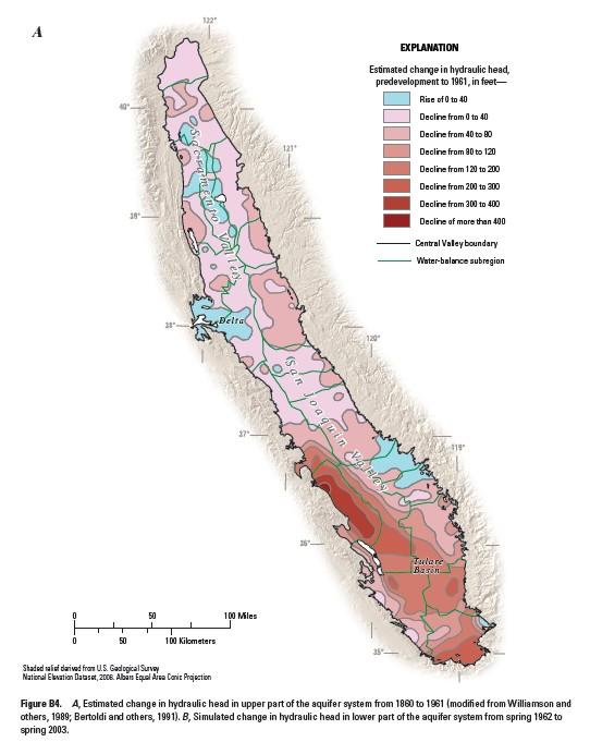
12 Faunt, Chapter B, 2009.

13 Clark, B.R., Hart, R.M., and Gurdak, J.J., 2011, Groundwater availability of the Mississippi embayment: U.S. Geological Survey Professional Paper 1785, 62 p.

14 Clark and others, 2011

15 Drawdown in Mississippi River Alluvial Aquifer in 2007 from Clark and others, 2011

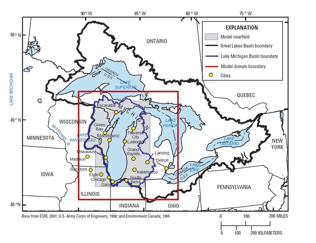
16 Water Availability and Use Great Lakes Basin Pilot Funded in 2005, five-year project Groundwater, surface water, water use Develop methods for national program Respond to Great Lakes issues including development of the Great Lakes Compact Image from NOAA, Great Lakes Environmental Research Laboratory, AVHRR satellite imagery, 1995


17 Overview Great Lakes water availability characterized by regional abundance with potential for local shortages.
18 Many Factors Affect Water Availability Water Quantity Water Works Infrastructure And Existing Water Use Water Quality Water Availability Economic Factors Ecology, Recreation, and Instream Use Water Law And Regulations

19 Surface Water Analysis What are current streamflows and how have they changed over time? How will new withdrawals affect streamflow?

20 Surface Water Analysis Streamgage data are not available everywhere Developed a new method to: Estimate streamflow for any stream Integrate water use and streamflow data Account for trends in time
21 Streamgage data Result of the new method
22 Water Use How much water is withdrawn and how much water is used in the Great Lakes Basin? How does use vary in time and space across the basin? Future water availability depends on groundwater, surface water, and current water use

23 Mills, P.C., and Sharpe, J.B., 2010, Estimated withdrawals and other elements of water use in the Great Lakes Basin of the United States in 2005: U.S. Geological Survey Scientific Investigations Report , 95 p.

24 Mills, P.C., and Sharpe, J.B., 2010.

25 Public-supply withdrawals 3,800 million gallons per day 17.7 million people Groundwater 12% Surface Water 88% Mills, P.C., and Sharpe, J.B., Self-supply domestic withdrawals 410 million gallons per day 5.2 million people Surface Water < 1% Groundwater 99%

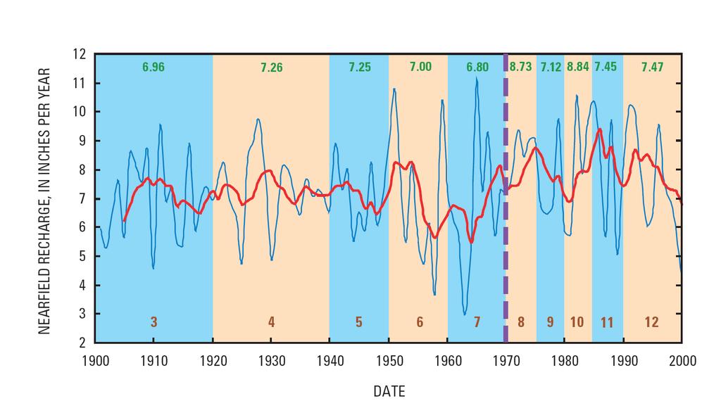
26 Mills, P.C., and Sharpe, J.B., 2010.

27 Groundwater availability How much groundwater is in storage? What are groundwater divides? How has development changed groundwater levels and availability? What are potential constraints limiting groundwater availability?

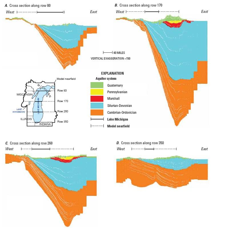
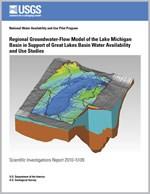
28 Groundwater flow model SEAWAT density dependent MODFLOW 20 layers ~ 2 million cells in 1 steadystate and 12 transient stress periods Heterogeneous properties
29

30 Water use, up to 1.1 billion gallons per day; 13,300 wells total across all stress periods (+ Milwaukee deep tunnel, 270 nodes) Buchwald, Luukkonen, and Rachol, USGS

31 Water use, up to 1.1 billion gallons per day; 13,300 wells total across all stress periods (+ Milwaukee deep tunnel, 270 nodes) Buchwald, Luukkonen, and Rachol, USGS
32

33 Recharge Westenbroek, S.M., Kelson, V.A., Dripps, W.R., Hunt, R.J., and Bradbury,K.R., 2009, SWB A modified Thornthwaite-Mather Soil-Water Balance code for estimating ground-water recharge: U.S. Geological Survey Techniques and Methods 6-A31, 65 p. Calibrated to be consistent with baseflow estimates
34
35

36 Properties of glacial deposits 3 model layers ~ 1200 ft thick Water well records and regional geological maps: (Arihood, USGS)

37 RESULTS. Water levels and drawdown Water budgets Sources of water to wells Indicators of sustainability Inset model
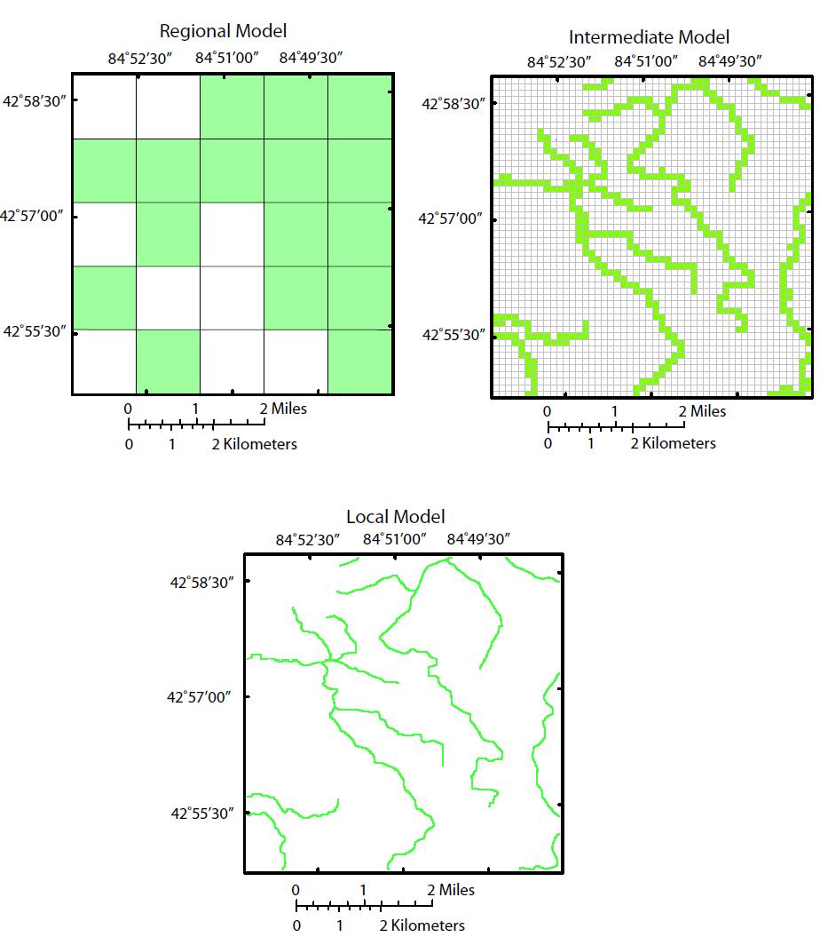
38 Water Budget by Stress Period for Lake Michigan Basin Flux, in million gallons per day 25, Stress Period ,000 15,000 Lateral Flow In (net) 10,000 Storage Source Surface Water In 5,000 Recharge In 0-5,000 Wells Out -10,000 Lake Michigan Out -15,000 Storage Sink Inland Lakes Out -20,000 Streams Out -25,000 P redev Water Budget Changes from Previous Stress Period for Lake Michigan Basin 1 10,000 Flux, in million gallons per day 8, Stress Period 6,000 Lateral Flow In (net) 4,000 Storage Source Surface Water In 2,000 Recharge In 0 Wells Out -2,000 Lake Michigan Out -4,000 Storage Sink -6,000 Inland Lakes Out -8,000 Streams Out P redev
39

40 Source of water to wells, 2005, shallow

41 Source of water to wells, 2005, deep

42 Water Table

43 St. Peter drawdown:
44 Indicators DEMAND TO SUPPLY RATI0 for a given area at given time= (Pumping Injection)t (Sum of natural inflows)t, no pumping BASEFLOW REDUCTION INDEX for a given area at given time= (Net Baseflowt Net Baseflowt, no pumping) (Net Baseflowt, no pumping) Where net baseflow = SWout - SWin x 100 Weiskel and others, 2007 Cherkauer, 2009 Great Lakes Pilot, 2010
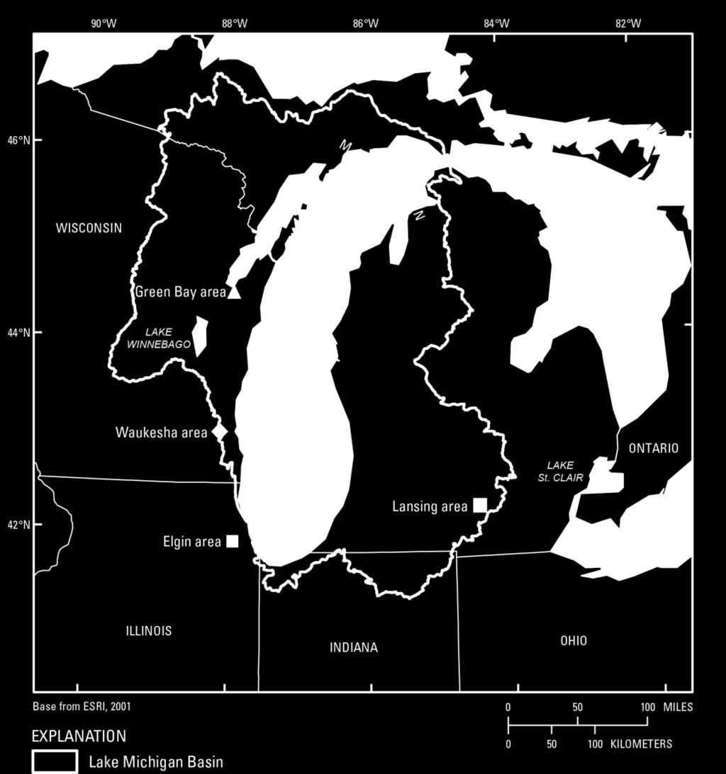
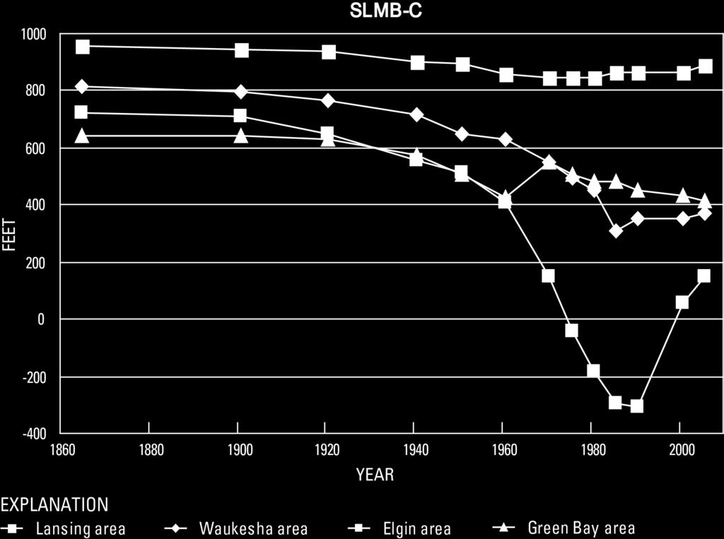
 Green Bay area in NE_WI (2 counties) Baseflow Reduction relative to natural flow: greater than")
45 Indicators for Focus Areas Demand relative to natural supply: big range Focus Areas Lansing area in SLP_MI (4 counties) Green Bay area in NE_WI (2 counties) Baseflow Reduction relative to natural flow: greater than 5%
 180962.6 102051 * 5000 x 5000 453.7 50600 500 x 500 21.6 118336 71.5 x 71.")
46 Ground-Water-Flow Model: Regional to Local Scales Scale Regional Intermediate Local Area (mi2) Cells per layer Cell size (ft) * 5000 x x x 71.5 * Smallest cells in non-uniform grid near field
47
")
48 (Hoard, 2010)
")
49 (Hoard, 2010)
50 Climate variability and change simulation Climate input from a downscaled atmosphere-ocean couple general circulation model (Hayoe and others, 2008) A1 fi scenario (high global greenhouse gas emission) AOGCM input to soil-water-balance model to estimate recharge Hayhoe, K., C. Wake, B. Anderson, X.-L. Liang, E. Maurer, J. Zhu, J. Bradbury, A. DeGaetano, A. Stoner and D. Wuebbles Regional Climate Change Projections for the Northeast USA: Mitigation and Adaptation Strategies for Global Change, Vol. 13, No. 5-6, p
51 (Hoard, 2010)
52 Relation to the Great Lakes Compact.. Strengthen the scientific basis for sound water management (Section 1.4) Role of groundwater (Section 1.4) Water use and development of the required cumulative impact assessment (Section 4.15).. Consider adaptive management principles and approaches recognizing, considering, and providing adjustments for the uncertainties in, and evolution of, science concerning the Basin s water resources, watersheds and ecosystems (Section 4.15)


53 Great Lakes Pilot Regional abundance does not mean water will always be available where and when it is needed. Regional study provides information that local stakeholders can build on to make decisions.
National Strategy for the Assessment of Water Availability and Use in the United States
 Philippine National Workshop Water Availability Enhancement (WAVE) Project March 1-4, 2011 National Strategy for the Assessment of Water Availability and Use in the United States Kevin F. Dennehy Reston,
Investigation of the Coastal Lowlands Aquifer System
 Investigation of the Coastal Lowlands Aquifer System Michael Bradley, Linzy Foster, and Brian Clark U.S. Geological Survey Alabama Water Resources Conference and Symposium Sept 7-9, 2016 The information
Context for Central Sands Water Use Trends and Impacts
 Context for Central Sands Water Use Trends and Impacts Wisconsin Food, Land, and Water meeting Wisconsin Rapids, WI November 10, 2016 Kenneth R. Bradbury Wisconsin Geological and Natural History Survey,
NOAA, Mantua (2010) NOAA (2010) Modified from McCabe et al., s Dust Bowl. 1950s drought
 NOAA (2010) Modified from McCabe et al., s Dust Bowl. 1950s drought") Interannual to Multidecadal Climate Variability Effects on Sustainable Groundwater for Agriculture Jason Gurdak, PhD Assistant Professor Department of Geosciences San Francisco State University High Plains
Interannual to Multidecadal Climate Variability Effects on Sustainable Groundwater for Agriculture Jason Gurdak, PhD Assistant Professor Department of Geosciences San Francisco State University High Plains
Steven M. Peterson, PG, J.S. Stanton, N.A. Houston, S.L. Qi, A.T. Flynn, and D.W. Ryter U.S. Department of the Interior U.S.
 The High Plains Groundwater Availability Study: Abundant Groundwater Doesn t Necessarily Mean Abundant Surface Water Steven M. Peterson, PG, J.S. Stanton, N.A. Houston, S.L. Qi, A.T. Flynn, and D.W. Ryter
Comments on a Need for Improved Data on Water Use
 Comments on a Need for Improved Data on Water Use Presentation at Roundtable on Science and Technology Sujoy Roy, Tetra Tech December 11, 2014 1 Overview Current status of national-scale water use reporting
Virtual Water Accounting: A New Framework for Managing Great Lakes Water Resources
 Virtual Water Accounting: A New Framework for Managing Great Lakes Water Resources Alex Mayer, Michigan Technological University Ben Ruddell, Arizona State University Stanley Mubako, University of Texas,
USGS Virginia Water Science Center: Scientific Support to the Virginia Department of Environmental Quality Groundwater Withdrawal Permitting Program
 USGS Virginia Water Science Center: Scientific Support to the Virginia Department of Environmental Quality Groundwater Withdrawal Permitting Program Reported and Estimated Withdrawals for Virginia Coastal
Characterizing Groundwater and Surface- Water Interactions in Selected Northeast Twin Cities Lakes
 Characterizing Groundwater and Surface- Water Interactions in Selected Northeast Twin Cities Lakes Chapter A: Statistical Analysis and Field Study Chapter B: Groundwater-Flow Simulation Perry M. Jones,
Predicting Groundwater Sustainability: What Tools, Models and Data are Available?
 Predicting Groundwater Sustainability: What Tools, Models and Data are Available? Ray Wuolo Barr Engineering Company Assessing Sustainability is All About: Predicting (or describing) how potentiometric
Streamflow Depletion by Pumping Wells and the Michigan Water- Withdrawal Assessment Process
 Streamflow Depletion by Pumping Wells and the Michigan Water- Withdrawal Assessment Process Howard W. Reeves, USGS Michigan-Ohio Water Science Center Water in the West, Groundwater Data Workshop Stanford
Role of NHD/NHDPlus for environmental-flow based legislation in Michigan and environmental-flow framework for the US Great Lakes Basin
 Role of NHD/NHDPlus for environmental-flow based legislation in Michigan and environmental-flow framework for the US Great Lakes Basin Howard W. Reeves, USGS Michigan-Ohio Water Science Center Paul W.
Western Groundwater: A Status Report and a Look Ahead
 Western Groundwater: A Status Report and a Look Ahead Dr. Leonard F. Konikow Scientist Emeritus, U.S. Geological Survey Reston, VA University of Colorado Getches-Wilkinson Center for Natural Resources,
Groundwater in the Santa Rosa Plain
 . Groundwater in the Santa Rosa Plain Marcus Trotta, PG, CHg Principal Hydrogeologist Sonoma County Water Agency Santa Rosa Plain Groundwater Sustainability Agency October 12, 2017 www.sonomacountywater.org
What s New in Groundwater at the USGS: Data, Tools, Assessments, and Integrated Modeling
 What s New in Groundwater at the USGS: Data, Tools, Assessments, and Integrated Modeling William L. Cunningham Senior Science Advisor for Groundwater Director, Earth Systems Processes Division U.S. Geological
Overview of Water Resources (Part 2): Groundwater in Sonoma Valley
: Groundwater in Sonoma Valley") . Overview of Water Resources (Part 2): Groundwater in Sonoma Valley Marcus Trotta, PG, CHg Principal Hydrogeologist Sonoma County Water Agency Sonoma Valley Groundwater Sustainability Agency October 23,
. Overview of Water Resources (Part 2): Groundwater in Sonoma Valley Marcus Trotta, PG, CHg Principal Hydrogeologist Sonoma County Water Agency Sonoma Valley Groundwater Sustainability Agency October 23,
Integrated Water Management Modeling Framework in Nebraska
 Integrated Water Management Modeling Framework in Nebraska Association of Western State Engineers Spring Workshop Salt Lake City, Utah June 9, 2015 Mahesh Pun, EIT Integrated Water Management Analyst Nebraska
groundwater/surface-water interactions Evan Christianson, PG Barr Engineering Company
 groundwater/surface-water interactions Evan Christianson, PG Barr Engineering Company Discussion of. Groundwater/Surface-Water Interactions Groundwater Recharge Impacts from Pumping Potential effect on
Using Your Computer for Water Withdrawal Planning and Groundwater Mapping
 Michigan s Water Withdrawal Assessment Tool An Overview Distinguished Senior Research Specialist Michigan State University Dept. of Geography And Institute of Water Research 1 / 29 Act 451 of 1994 (Natural
STRAWMAN OUTLINE March 21, 2008 ISWS/ISGS REPORT ON THE OPPORTUNITIES AND CHALLENGES OF MEETING WATER DEMAND IN NORTH-EAST ILLINOIS
 STRAWMAN OUTLINE March 21, 2008 ISWS/ISGS REPORT ON THE OPPORTUNITIES AND CHALLENGES OF MEETING WATER DEMAND IN NORTH-EAST ILLINOIS REPORT TO BE DELIVERED TO THE RWSPG BY SEPTEMBER 30, 2008 Table of Contents
Analysis and Simulation of Conjunctive Water Use for Agricultural Settings with the Farm Process for MODLFOW
 Analysis and Simulation of Conjunctive Water Use for Agricultural Settings with the Farm Process for MODLFOW Randy Hanson 1, and Wolfgang Schmid 2 1 U.S. Geological Survey 2 University of Arizona Resource
Groundwater Resources Program Regional Groundwater Evaluation
 Groundwater Resources Program Regional Groundwater Evaluation Appalachian Plateaus Aquifer System Kurt McCoy, David Nelms Mark Kozar Richard Yager David Ladd USGS Virginia Water Science Center USGS West
A Roadmap for the Scientific Assessment of Maryland s Coastal Plain Groundwater Resources
 A Roadmap for the Scientific Assessment of Maryland s Coastal Plain Groundwater Resources David W. Bolton Maryland Geological Survey Robert J. Shedlock U.S. Geological Survey James M. Gerhart U.S. Geological
Southeastern Wisconsin Regional Water Supply Planning Program Update. Focus on Alternative and Preliminary Recommended Plans
 Southeastern Wisconsin Regional Water Supply Planning Program Update Focus on Alternative and Preliminary Recommended Plans Milwaukee County Public Informational Meetings January 12, 13, & 14, 2009 #141727
NAWQA Cycle 3 Groundwater Studies in the Glacial Aquifer Paul Juckem, USGS-WiWSC Contributions from: Sandy Eberts, Ken Belitz, Daniel Feinstein, Mike
 NAWQA Cycle 3 Groundwater Studies in the Glacial Aquifer Paul Juckem, USGS-WiWSC Contributions from: Sandy Eberts, Ken Belitz, Daniel Feinstein, Mike Fienen, Leon Kauffman, Jim Tesoriero, Chris Shope,
Hydroinformatics to Assess Management Regimes: Using Directed Networks and a Groundwater Decision Support System to Span Science and Policy
 Hydroinformatics to Assess Management Regimes: Using Directed Networks and a Groundwater Decision Support System to Span Science and Policy Suzanne A. Pierce, John M. Sharp, Jr., Jenifer Wehner Department
Chippewa County Groundwater Study 3 rd Public outreach meeting
 Chippewa County Groundwater Study 3 rd Public outreach meeting Today s outline Brief review of hydrogeology (USGS) Brief overview of the groundwater study (WGNHS) Subsurface data collection and hydrostratigraphy
The DNR is charged with managing waters resources to assure an adequate and sustainable supply for multiple uses.
 The DNR is charged with managing waters resources to assure an adequate and sustainable supply for multiple uses. Minnesota Laws 2015, chapter 4, article 4, directed the Department of Natural Resources
MEMORANDUM. RAI Responses Related to East Lake Road Wellfield Drawdown Analysis, WUP No SDI Project No. PCF-180.
 SDI Environmental Services, Inc. 13911 N. Dale Mabry Hwy. Suite 201, Tampa, FL 33618; (813) 961-1935 MEMORANDUM TO: FROM: SUBJECT: Dave Slonena, P.G., Pinellas County Cathleen Beaudoin Jonas RAI Responses
Southeastern Wisconsin Regional Water Supply Planning Program Update. Focus on Alternative and Preliminary Recommended Plans
 Southeastern Wisconsin Regional Water Supply Planning Program Update Focus on Alternative and Preliminary Recommended Plans Waukesha County Public Informational Meeting January 20, 2009 #142063 Background
WATER RESOURCES SUSTAINABILITY AND HOW IT IS IMPLEMENTED IN THE STATE OF KANSAS, USA
 WATER RESOURCES SUSTAINABILITY AND HOW IT IS IMPLEMENTED IN THE STATE OF KANSAS, USA Marios Sophocleous Kansas Geological Survey The University of Kansas Lawrence, Kansas E-mail: marios@kgs.ku.edu SUSTAINABLE
1. Concept: A single groundwater flow system occurs throughout the central sands
 Groundwater quantity fundamentals in Wisconsin s central sands region Prepared for the Wisconsin Food, Land, and Water Project Groundwater Quantity Work Group, February, 2017, revised March 13, 2017 following
ALABAMA S FUTURE WITHOUT SUSTAINABLE WATER RESOURCES? NOT ON OUR WATCH. Marlon Cook
 ALABAMA S FUTURE WITHOUT SUSTAINABLE WATER RESOURCES? NOT ON OUR WATCH Marlon Cook Geological Survey of Alabama Groundwater Assessment Program Sustainable Water Resources Sustainable Yield: The water extraction
Georgia s Aquifers. USGS Fact Sheet
 Georgia s Aquifers USGS Fact Sheet 2006-3077 1 2005 Groundwater Use by Aquifer Withdrawal (mgd) 700 600 500 400 300 200 100 0 55.4% 17.5% 7.6% 6.0% 9.2% 4.3% 60% 50% 40% 30% 20% 10% 0% Percent of Withdrawal
Effect of Conjunctive Use of Water for Paddy Field Irrigation on Groundwater Budget in an Alluvial Fan ABSTRACT
 1 Effect of Conjunctive Use of Water for Paddy Field Irrigation on Groundwater Budget in an Alluvial Fan Ali M. Elhassan (1), A. Goto (2), M. Mizutani (2) (1) New Mexico Interstate Stream Commission, P.
Groundwater in the Eel River Valley: Responding to the New State Groundwater Legislation
 Groundwater in the Eel River Valley: Responding to the New State Groundwater Legislation Eel River Forum Riverwalk Lodge, Fortuna May 20, 2015 Public Works Department Hank Seemann, Deputy-Director Signed
Climate Change and Drought Scenarios for Water Supply Planning
 Climate Change and Drought Scenarios for Water Supply Planning Analyses of the sensitivity of water availability (surface water and groundwater) and water demand to climate change and drought will be conducted
A Wed-based Spatial Decision Support System for Potomac Basin Consumptive Water-use. Jan Ducnuigeen Advisor: Patrick Reed
 A Wed-based Spatial Decision Support System for Potomac Basin Consumptive Water-use Jan Ducnuigeen Advisor: Patrick Reed Background: The Potomac River & What is consumptive water use? Goals and Objectives:
Indicators of Hydrologic Stress in Massachusetts
 Indicators of Hydrologic Stress in Massachusetts Sara Brandt 1, Richard M. Vogel 2 and Stacey Archfield 3 1 Department of Civil and Environmental Engineering, Tufts University, Medford, MA, email: sara.brandt@tufts.edu,
Water for All, Now and Into the Future: Water Quantity in Wisconsin. A report by the Sierra Club-John Muir Chapter
 Water for All, Now and Into the Future: Water Quantity in Wisconsin A report by the Sierra Club-John Muir Chapter Table of Contents Background The Importance of Water Quantity Water Use in Wisconsin Excessive
USGS Water Quantity Studies in Nevada
 USGS Water Quantity Studies in Nevada Michael L. Strobel, Deputy Director Daniel Bright, Studies Chief, S. NV Nevada Water Science Center EXHIBIT F WATER RESOURCES Meeting Date: 10-13-05 Document consists
Optimal management of groundwater pumping of the cache critical groundwater area, Arkansas
 Appl Water Sci (2015) 5:209 219 DOI 10.1007/s13201-014-0173-y ORIGINAL ARTICLE Optimal management of groundwater pumping of the cache critical groundwater area, Arkansas Haveen Rashid Haydar Al-Shukri
Rockland County s Water Resources -Selected Findings from the USGS Study- Paul M. Heisig, Hydrologist New York USGS Water Science Center Troy, NY
 Rockland County s Water Resources -Selected Findings from the USGS Study- Paul M. Heisig, Hydrologist New York USGS Water Science Center Troy, NY Subject to Permits Water Sources Rockland County, NY -Lake
Associate Groundwater Resources Engineer Principal Hydrogeologist
 Project No.: 140369 March 2, 2016 Revised March 25, 2016 To: Cami Apfelbeck From: Peter Bannister, PE Timothy Flynn, LHG, CGWP Associate Groundwater Resources Engineer Principal Hydrogeologist pbannister@aspectconsulting.com
LAKE LABELLE DEWATERING MODEL. AUTHOR Gail Murray Doyle, P.G. September Murray Consultants, Inc 769 Skyview Dr Hayesville, NC
 LAKE LABELLE DEWATERING MODEL AUTHOR Gail Murray Doyle, P.G. September 2013 Murray Consultants, Inc 769 Skyview Dr Hayesville, NC 28904 828-389-2476 LAKE LABELLE DEWATERING MODEL INTRODUCTION Purpose The
Hydrology in Western Colorado: Planning for Resilience
 Hydrology in Western Colorado: Planning for Resilience 2016 Water Course February 18, 2016 Dr. Gigi A. Richard Director, Hutchins Water Center at CMU Professor, Geology Coordinator, Civil Engineering Partnership
DROUGHT IN ILLINOIS: IMPACTS TO WATER SUPPLY
 DROUGHT IN ILLINOIS: IMPACTS TO WATER SUPPLY 11 th Biennial Governor s Conference on the Management of the Illinois River System October 3, 2007 Peoria Derek Winstanley Chief Fresh water use in Illinois:
Irrigation modeling in Prairie Ronde Township, Kalamazoo County. SW Michigan Water Resources Council meeting May 15, 2012
 Irrigation modeling in Prairie Ronde Township, Kalamazoo County SW Michigan Water Resources Council meeting May 15, 2012 Development of a Groundwater Flow Model INFLOWS Areal recharge from precipitation
Municipal Groundwater Flow Modelling Study. Town of Torbay, NL
 Municipal Groundwater Flow Modelling Study Town of Torbay, NL October 19, 2015 Agenda 1 Purpose 2 What is a Groundwater Model 3 Approach 4 Conceptual Model & GW Flow Model Construction 5 Model Predictions
The Corning Primary Aquifer -One of 18. NYSDEC Primary Aquifers in New York
 The Corning Primary Aquifer -One of 18 NYSDEC Primary Aquifers in New York NYSDEC Primary and Principal Aquifers PRIMARY AQUIFERS (18) Highly productive aquifers presently being utilized by major municipal
Water Sustainability: Toward A Common Understanding Michigan Case Study
 Water Sustainability: Toward A Common Understanding Michigan Case Study November 2, 28 University of Minnesota, St. Paul Campus Howard W. Reeves, USGS Michigan Water Science Center U.S. Department of the
U.S. Geological Survey Streamflow data in Michigan Using the USGS NWIS database MDOT Bridge Scour Conference October 5, 2017
 U.S. Geological Survey Streamflow data in Michigan Using the USGS NWIS database MDOT Bridge Scour Conference October 5, 2017 Tom Weaver Eastern Hydrologic Data Chief Upper Midwest Water Science Center
Hydrology models (Hydrology)
") Table of Contents Biophysical...1/3 models: Hydrology...1/3 1 Introduction...1/3 2 Methodology...1/3 3 Process...1/3 4 Review...1/3 4.1 Evaluation results...1/3 4.2 Experiences...1/3 4.3 Combinations...2/3
Table of Contents Biophysical...1/3 models: Hydrology...1/3 1 Introduction...1/3 2 Methodology...1/3 3 Process...1/3 4 Review...1/3 4.1 Evaluation results...1/3 4.2 Experiences...1/3 4.3 Combinations...2/3
Vermont Groundwater Monitoring Network: A real-time tool for assessing climatic drought
 Vermont Groundwater Monitoring Network: A real-time tool for assessing climatic drought Richard Kiah, New England Water Science Center June 6, 2017 Lyndonville, VT June 7, 2017 Manchester, VT U.S. Department
DOE s Net-Zero Energy Commercial Building Initiative
 DOE s Net-Zero Energy Commercial Building Initiative Drury B. Crawley, Ph.D. U.S. Department of Energy Energy Efficiency and Renewable Energy Dallas, Texas October 5, 2009 Buildings: Largest Energy Consumer
Aquifer Characterization and Drought Assessment Ocheyedan River Alluvial Aquifer
 Aquifer Characterization and Drought Assessment Ocheyedan River Alluvial Aquifer Iowa Geological Survey Water Resources Investigation Report 10 Aquifer Characterization and Drought Assessment Ocheyedan
NGWA INFORMATION BRIEF
 Brackish Groundwater What is brackish water? Brackish water does not have an exact definition, but it is typically defined as distastefully salty but less saline than seawater (between 1,000 to 10,000
USGS Groundwater Resources Program Regional Groundwater Evaluations
 USGS Groundwater Resources Program Regional Groundwater Evaluations -- Northern Atlantic Coastal Plain Aquifer System -- John Masterson* New England Water Science Center Northborough, Massachusetts Delaware
Mapping Groundwater Recharge Rates Under Multiple Future Climate Scenarios in Southwest Michigan
 http://mi.water.usgs.gov/reports/images/cover_med01_4227.jpg Mapping Groundwater Recharge Rates Under Multiple Future Climate Scenarios in Southwest Michigan Glenn O Neil Institute of Water Research Michigan
How Groundwater Interacts with Lakes and Streams
 How Groundwater Interacts with Lakes and Streams Ken Bradbury Wisconsin Geological and Natural History Survey University of Wisconsin-Extension AGI Critical Issues Webinar July 13, 2015 Groundwater basics
Comparison of Surface- Groundwater Interaction Model Approaches to Establish Surface Water Protection Zones in Stanislaus County
 Comparison of Surface- Groundwater Interaction Model Approaches to Establish Surface Water Protection Zones in Stanislaus County Bob Abrams, Ph.D., PG, CHG, Jacobson James & Associates Mike Tietze, PG,
Dynamic groundwater-river interaction model for planning water allocation in a narrow valley aquifer system of the Upper Motueka catchment
 Dynamic groundwater-river interaction model for planning water allocation in a narrow valley aquifer system of the Upper Motueka catchment Timothy Hong t.hong@gns.cri.nz Gilles Minni g.minni@gns.cri.nz
Science supporting the Great Lakes Water Quality Agreement: Groundwater and Climate Change Information Needs and Gaps
 Science supporting the Great Lakes Water Quality Agreement: Groundwater and Climate Change Information Needs and Gaps Latornell Symposium November 19 2015 Great Lakes Water Quality Agreement Purpose: provide
Memorandum. Introduction. Carl Einberger Joe Morrice. Figures 1 through 7
 Memorandum TO: Michelle Halley, NWF DATE: October 9, 2007 FROM: Carl Einberger Joe Morrice PROJ. NO.: 9885.000 CC: Project File PROJ. NAME: National Wildlife Federation ATTACHMENTS: Tables 1 through 6
Is it time for us to go to fully integrated models for stream-aquifer management?
 Is it time for us to go to fully integrated models for stream-aquifer management? Tissa H. Illangasekare, PhD, PE, P.Hyd, BCEE,DWRE AMAX Distinguished Chair and Professor of Civil and Environmental Engineering
Purpose. Utilize groundwater modeling software to forecast the pumping drawdown in a regional aquifer for public drinking water supply
 MODFLOW Lab 19: Application of a Groundwater Flow Model to a Water Supply Problem An Introduction to MODFLOW and SURFER The problem posed in this lab was reported in Chapter 19 of "A Manual of Instructional
PUBLIC POLICY FORUM February 22, 2005
 SOUTHEASTERN WISCONSIN WATER SUPPLY ISSUES AND REGIONAL WATER SUPPLY PLANNING PROGRAM OVERVIEW Presentation for PUBLIC POLICY FORUM February 22, 2005 SOUTHEASTERN WISCONSIN WATER SUPPLY ISSUES AND REGIONAL
WATER SUPPLY ISSUES IN SOUTHEASTERN WISCONSIN: TECHNICAL AND POLICY NEEDS AND CHALLENGES
 WATER SUPPLY ISSUES IN SOUTHEASTERN WISCONSIN: TECHNICAL AND POLICY NEEDS AND CHALLENGES Presentation for Conference STRADDLING THE DIVIDE WATER SUPPLY PLANNING IN THE LAKE MICHIGAN REGION February 15-16,
Pilot area reference WP. Varde Pilot Area. + Varde: 14,000 inhabitants + Lerpøtvej Waterworks: 1,3 mill m3/year
 Pilot area reference WP Varde Pilot Area + Varde: 14,000 inhabitants + Lerpøtvej Waterworks: 1,3 mill m3/year Challenges - related to drinking water Organic content (brown water) in Miocene aquifers and
Bayesian Uncertainty Quantification in SPARROW Models Richard B. Alexander
 Bayesian Uncertainty Quantification in SPARROW Models Richard B. Alexander National Water Quality Assessment Project U.S. Geological Survey Reston, VA Chesapeake Bay STAC, Assessing Uncertainty Workshop,
Water Use in Minnesota
 Water Use in Minnesota Swackhamer, D.L. and Fairbairn, D. University of Minnesota Water Resources Center August 2010 Table of Contents A. Instream Uses... 3 B. Offstream Uses... 4 C. Total National, State,
A Time Series Approach to Instream Flow Mitigation Forecasting. Presented by Alan Keizur
 A Time Series Approach to Instream Flow Mitigation Forecasting Presented by Alan Keizur Agenda Brief background on project Brief overview of model Some results and application GoldSim highlights Introduction
Water Supply in Coastal Georgia Meeting Water Demand Using Alternative Water Sources to the Upper Floridan Aquifer
 Water Supply in Coastal Georgia Meeting Water Demand Using Alternative Water Sources to the Upper Floridan Aquifer John Clarke U.S. Geological Survey Georgia Water Science Center U.S. Department of the
USGS LAKE STUDIES CASE STUDY: SILVER LAKE (OCEANA COUNTY, MI) Angela Brennan, Hydrologist - US Geological Survey Upper Midwest Water Science Center,
 Angela Brennan, Hydrologist - US Geological Survey Upper Midwest Water Science Center,") USGS LAKE STUDIES CASE STUDY: SILVER LAKE (OCEANA COUNTY, MI) Angela Brennan, Hydrologist - US Geological Survey Upper Midwest Water Science Center, Lansing, MI October 18, 2017 USGS Inland lake studies
USGS LAKE STUDIES CASE STUDY: SILVER LAKE (OCEANA COUNTY, MI) Angela Brennan, Hydrologist - US Geological Survey Upper Midwest Water Science Center, Lansing, MI October 18, 2017 USGS Inland lake studies
Ottawa County Water Resources Study Phase 2
 Ottawa County Water Resources Study Phase 2 Overview David P. Lusch, Ph.D. Department of Geography and Institute of Water Research Michigan State University 1 / 24 Ottawa County Planning and Performance
USGS Hydrologic Monitoring and Research in the Barnegat Bay Watershed
 USGS Hydrologic Monitoring and Research in the Barnegat Bay Watershed New Jersey Department of Environmental Protection Technical Seminar for In-House Staff: The Science of Barnegat Bay July14, 2010 Robert
Perspectives on the Nation s Ground- Water Availability. William M. Alley Sioux Falls October 30, 2007
 Perspectives on the Nation s Ground- Water Availability William M. Alley Sioux Falls October 30, 2007 Principal Aquifers of the United States Source: Ground Water Atlas of the United States http://capp.water.usgs.gov/gwa/
GROUNDWATER AVAILABILITY MODELING OF THE WEST NISHNABOTNA AQUIFER IN IOWA. Iowa Geological Survey Water Resource Investigation Report 3
 GROUNDWATER AVAILABILITY MODELING OF THE WEST NISHNABOTNA AQUIFER IN IOWA Iowa Geological Survey Water Resource Investigation Report 3 Iowa Department of Natural Resources Patricia L. Boddy, Interim Director
Climate Change and Sea Level Rise
 Potential Effects of Sea-Level Rise on the Hydrologic System of Cape Cod, Massachusetts 3 rd Cape Coastal Conference, December 7, 2016 Continued release of anthropogenic greenhouse gases is resulting in
Temporal and Spatial Variability. Natural Groundwater Recharge
 Temporal and Spatial Variability of Natural Groundwater Recharge Weston Dripps Mary P. Anderson Kenneth W. Potter University of Wisconsin Water Resources Institute Groundwater Research Project September
Daniel R. Hadley, PG and Daniel B. Abrams, PhD
 Revisiting one of the largest aquifer tests in history: Implications for fault zone hydrogeology and the declining groundwater supply in Northeastern Illinois Daniel R. Hadley, PG and Daniel B. Abrams,
Simulating hydrologic and biologic response to land use and climate change
 Simulating hydrologic and biologic response to land use and climate change Trout Lake Black Earth Randy Hunt, John Walker, Jeff Steuer (and Steve Westenbroek) USGS WRD, Middleton, WI Coupled ground water
FREQUENTLY ASKED QUESTIONS GUELPH/GUELPH-ERAMOSA TIER 3 WATER BUDGET AND LOCAL AREA RISK ASSESSMENT STUDY
 FREQUENTLY ASKED QUESTIONS GUELPH/GUELPH-ERAMOSA TIER 3 WATER BUDGET AND LOCAL AREA RISK ASSESSMENT STUDY Contents Overview... 3 1. What is a Tier 3 Water Budget Study?... 3 2. How does a Tier 3 Water
RANCHO CALIFORNIA WATER DISTRICT GROUNDWATER WORKSHOP. Groundwater Production History and Outlook for the Temecula Valley Groundwater Basin
 RANCHO CALIFORNIA WATER DISTRICT GROUNDWATER WORKSHOP by: Dennis Williams July 22, 2014 1 Overview Geohydrology of the Rancho California Area RCWD Ground Water Management Plan Ground Water Management Tools
AN INTEGRATED GROUNDWATER RECHARGE AND FLOW MODEL TO PREDICT BASE FLOW
 AN INTEGRATED GROUNDWATER RECHARGE AND FLOW MODEL TO PREDICT BASE FLOW By XIAOJING NI A THESIS Submitted to Michigan State University in partial fulfillment of the requirements for the degree of Civil
Subject: Groundwater Model Update and Scope for Fiscal Year
 1814 Franklin St, Suite 501 Oakland, CA 94612 Mr. Ron Duncan General Manager, Soquel Creek Water District On behalf of Santa Cruz Mid County Groundwater Agency Executive Staff PO Box 1550 Capitola, CA
Christopher Fields, PhD Candidate Drs. Lynn Johnson and John Labadie Dept. Civil and Environmental Engineering Cooperative Institute for Research on
 Christopher Fields, PhD Candidate Drs. Lynn Johnson and John Labadie Dept. Civil and Environmental Engineering Cooperative Institute for Research on the Atmosphere Colorado State University 19 November
Kane County Water Resources Investigations: Simulation of Groundwater Flow in Kane County and Northeastern Illinois
 Kane County Water Resources Investigations: Simulation of Groundwater Flow in Kane County and Northeastern Illinois Scott C. Meyer, P.G. George S. Roadcap, Ph.D., P.G. Yu-Feng Lin, Ph.D. Douglas D. Walker,
DRAFT. APPENDIX F Groundwater Flow Model Proposed El Segundo Desalination Facility
 APPENDIX F Proposed El Segundo Desalination Facility Proposed El Segundo Desalination Facility 1. GROUNDWATER FLOW MODEL Based on review of offshore and onshore hydrogeologic data including the Summer
Regional Aquifer Recharge to Support San Pedro River Baseflows, Flood Flows and Groundwater
 Regional Aquifer Recharge to Support San Pedro River Baseflows, Flood Flows and Groundwater Brooke Bushman & Holly Richter, AZ Water Projects November 7, 2017 San Pedro River Tributary of the Colorado
Nitrate Tracking in the Lower Yakima Basin
 Nitrate Tracking in the Lower Yakima Basin Matt Bachmann, Ph.D. September 19 th, 2013 U.S. Department of the Interior U.S. Geological Survey GWMA objectives reduce nitrate concentrations in groundwater
Identifying domestic well locations and populations served in the contiguous United States
 Identifying domestic well locations and populations served in the contiguous United States Tyler Johnson & Kenneth Belitz USGS National Water Quality Program Background More than 44 million people in the
Development of Groundwater Model for GMA-12 Using a Participatory Framework for Data Collection and Model Calibration
 Generalized Flowchart of Proposed Project Activities Development of Groundwater Model for GMA-12 Using a Participatory Framework for Data Collection and Model Calibration Submitted to: Texas Water Development
February 7 th, Background
 February 7 th, 2014 Dr. Reagan Waskom, Director Colorado Water Institute E-102 Engineering Building Colorado State University Fort Collins, CO 80523-2033 This memo serves as a final assessment by the Independent
USGS National Assessment of Groundwater Quality and the Utility of State Groundwater Data Sandra M. Eberts & Ken Belitz U.S.
 USGS National Assessment of Groundwater Quality and the Utility of State Groundwater Data Sandra M. Eberts & Ken Belitz U.S. Geological Survey Groundwater Protection Council Annual Forum September 29,
Investigation of sustainable development potential for Ulubey Aquifer System, Turkey
 doi:10.5194/piahs-364-513-2014 Evolving Water Resources Systems: Understanding, Predicting and Managing Water Society Interactions Proceedings of ICWRS2014, Bologna, Italy, June 2014 (IAHS Publ. 364, 2014).
Assessing Effects of Intraborehole Flow in Deep Monitoring Wells on Estimates of Aquifer Salinity Profiles
 Assessing Effects of Intraborehole Flow in Deep Monitoring Wells on Estimates of Aquifer Salinity Profiles Problem and Research Objectives Regulation of groundwater withdrawals at some aquifer locations
6.0 USGS MODEL. 6.1 Background
 6.0 USGS MODEL 6.1 Background A groundwater flow model is a simplification of a real groundwater flow system. Real groundwater flow systems are complex, and they are often simplified with a model for the
While requirements to leave water in
 UNIVERSITIES COUNCIL ON WATER RESOURCES, ISSUE 127, PAGES 76-86, FEBRUARY 2004 Hydrologic Aspects of Water Sustainability and Their Relation to a National Assessment of Water Availability and Use Paul
Assessing Water Use and Availability Trends in New Hampshire
 Assessing Water Use and Availability Trends in New Hampshire Brandon Kernen, PG NH Department of Environmental Services (603) 271-0660/Brandon.Kernen@des.nh.gov Existing Groundwater Use and Availability