CHAPTER FIVE Runoff. Engineering Hydrology (ECIV 4323) Instructors: Dr. Yunes Mogheir Dr. Ramadan Al Khatib. Overland flow interflow
|
|
|
- Eleanor Little
- 6 years ago
- Views:
Transcription
1 Engineering Hydrology (ECIV 4323) CHAPTER FIVE Runoff Instructors: Dr. Yunes Mogheir Dr. Ramadan Al Khatib Overland flow interflow Base flow Saturated overland flow ١
2 ٢ 5.1 Introduction To Runoff
3 Runoff Parts - Runoff normally applies to flow over a surface - Overland flow: is the surface runoff from tracts of land (or sheet flow) before it reaches a defined channel. - Stream flow is used to describe the drainage after it reaches a defined channel Drainage basins, watersheds, sub-basins, catchments: Defined by the total area contributing to a specific point. This point varies with the objectives of the project. ٣
4 Stream Flow Components: -Direct precipitation on the channel (typically incorporated into total basin area) -Overland flow: when soil moisture storage and depression storage are filled excess rainfall generates overland flow. -Interflow: all rainfall that infiltrates does not reach saturated zone (ground water). Under certain conditions infiltrated moisture can travel through shallow soil horizons. Usually only significant for highly permeable soils. -Baseflow: contribution to stream flow from groundwater Overland flow interflow Saturated overland flow Base flow ٤
5 5.2 Hydrograph - Streamflow in terms of discharge vs time is represented by the hydrograph. - Hydrograph components thus become, 1. surface runoff 2. interflow 3. baseflow 4. direct precipitation - Direct Runoff: all moisture that reaches the stream channel without first entering zone of saturation (overland flow + interflow) ٥ - Streamflow = direct runoff + baseflow
6 5.3 Runoff characteristics of streams -Perennial Stream (Fig 5.2) A stream which always carries some flow. It is always fed from groundwater base flow. Even during dry seasons the water table will be above the bed of the stream. -An intermittent stream (Fig 5.3) Stream is fed from groundwater base only in the wet season. During the wet season the water table is above the stream bed. During dry seasons the water table drops to a level lower than that of the stream bed; and therefore the stream dries up. -An ephemeral steam (Fig 5.4) No contribution from groundwater (base flow) to the stream (most rivers in arid zones) ٦
7 ٧ Water Year In annual runoff studies it is advantageous to consider a water year beginning from the time when the precipitation exceeds the average evaporation losses.
8 ٨ Stream is always fed from groundwater base flow
9 ٩ Stream is fed from Groundwater base only in the wet season
 to the stream (most rivers in arid")
10 ١٠ No contribution from groundwater (base flow) to the stream (most rivers in arid zones)
11 5.5 Flow-Duration curve - Is a plot of discharge against the percentage of time the flow was equaled or exceeded (Discharge-Frequency curve) -Step of construction the curve Stream flow discharge is arranged in decreasing order. Use class interval if we have very large number of records (example 5.4) Use plotting position to compute the probability of equal or exceeded. ١١ -m= order number of discharge (class value) -N= number of data -P p = percentage probability -Plot the discharge Q against P p (Fig 5.6) -Or semi-log or log-log paper (Fig 5.8)
12 5.5 Flow-Duration curve - The flow duration curve represents the cumulative frequency distribution -The percentage probability of time that flow magnitude in average year is equal or greater -Example 5.4 Q 50 = 100 m 3 /s ١٢
13 Example 5.4 The daily flows of a river for three consecutive years are shown in the table below. For convenience the discharges are shown in class intervals and the number of days the flow belonged to the class is shown. Calculate the 50 and 75% dependable flows for the river ١٣
14 ١٤
15 ١٥
16 ١٦ Flow-Duration Curve for different river types
17 ١٧
18 5.6 Flow mass curve - The flow-mass curve is a plot of cumulative discharge against time plotted in sequential order -The flow-mass curve integral curve (summation curve) of the hydrograph - See figure 5.9 ١٨
19 Flow mass curve (Fig. 5.9) ١٩ Check the excel example in class web page for more details on this figure
20 Flow mass curve - Unit is volume million m 3 or m 3 /s day, cm over a catchment area -Slope of the mass curve =dv/dt =Q = flow rate -Average flow rate in the time between tm and tn -Slope of line AB is the average over whole period records ٢٠
21 Calculation of storage volume -Assume there is a reservoir on a stream where FM curve is shown in Fig 5.9 and it is full at the beginning of a dry period, i.e. when the inflow rate is less than the withdrawal (demand) rate, the storage (S) of the reservoir S maximum of V D V ( ) = S V D =demand volume (withdrawal) V S = supply volume (Inflow) The storage S is the maximum cumulative deficiency in any dry season. It is obtained as the maximum difference in the ordinate between mass curves of supply & demand. If there are two dry periods, the minimum storage volume required is the largest of S 1 and S 2 (Fig. 5.9) ٢١
22 Calculation of storage volume - i.e. The minimum storage volume required by a reservoir is the largest value of S Refer to Figure 5.9 CD is drawn tangential to the first part of curve Q d slope of CD is a constant rate of withdrawal from the reservoir The lowest capacity is reached at E where EF is tangential at E S 1 : the water volume needed as storage to meet the maximum demand (reservoir is full) S 2 : is for C D Then the minimum reservoir storage required is the largest storage S 2 >S 1 ٢٢
23 Example 5.5 The following table gives the mean monthly flows in a river during Calculate the minimum storage required to maintain a demand rate of 40 m 3 /s. Month Jan Feb Mar Apr May June July Aug Sept Oct Nov Dec Mean Flow (m 3 /s) ٢٣
24 example 5.5 ٢٤ The actual number of days in the month are used in calculating the monthly flow volume. Volumes are calculated in units of cumec. day (= m 3 )
25 ٢٥ Example 5.5
26 ٢٦ Refer to Example 5.5 Compute the monthly flow volume by using the actual days in each month Compute the accumulated volume in (cumec day) or in m 3. Plot the flow mass curve (accumulated flow volume and time) Draw a tangential line with slope of 40 m 3 /s Slope = y/x y=x(slope) y= 60.8 days x 40 =2432 cumec-day To draw the demand line, the number of days in a month can be taken as 30.4 days.
27 Calculation of storage volume Refer to Example 5.5 -Flow mass curve (Figure 5.10) -Draw parallel line to AB in the valley point A B -Vertical value S 1 is the storage required to maintain the demand -From figure m 3 /s.day -Solve Example 5.6 ٢٧
28 Example 5.6 Work out the example 5.5 through arithmetic calculation without the use of the mass curve Month Jan Feb Mar Apr May June July Aug Sept Oct Nov Dec Mean Flow (m 3 /s) ٢٨
29 ٢٩ Example 5.6
30 ٣٠ Calculation of maintainable demand - The storage volume is given. Your job is now to determine the maximum demand that can be maintained by this given storage volume. - Fig. 5.11: -Tangents are drawn from the ridges and valleys of the mass curves at various slopes (since we still don t know the demand!). -The demand line that requires just the given storage is the proper demand that can be sustained by the reservoir in that dry period. -Similar demand lines are drawn at other valleys. -The smallest of the various demand rates thus is the maximum solid demand that can be sustained by the given storage - Check points 1 & 2 of page 162
31 Variable demand -In practice the demand rate varies with time to meet various end uses (such as irrigation, power and water supply needs, etc.) -A mass curve of demand is prepared and superposed on the flow-mass curve. ٣١
32 Mass curve of Flow and Mass curve of Variable Demand ٣٢
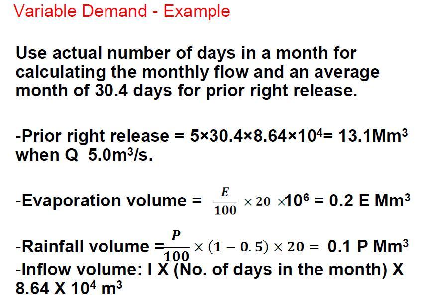
33 -In the analysis of problems related to reservoirs it is necessary to account for evaporation, leakage, and other losses from the reservoir. -These losses can either be included in demand rates or deducted from inflow rates. If you used the second method, the mass curve may have negative slopes at some points. -Solve Example 5.8 ٣٣
34 Example 5.8 -For a proposed reservoir the following data were calculated. The prior water rights required the release of natural flow or 5 m 3 /s, whichever is less. Assuming an average reservoir area of 20 km 2, estimate the storage required to meet these demands. (Assume the runoff coefficient of the area submerged by the reservoir = 0.5.) ٣٤
35 ٣٥
36 ٣٦
37 ٣٧ - HW is 5.6, 5.8, 5.10
Lecture 9A: Drainage Basins
 GEOG415 Lecture 9A: Drainage Basins 9-1 Drainage basin (watershed, catchment) -Drains surfacewater to a common outlet Drainage divide - how is it defined? Scale effects? - Represents a hydrologic cycle
Hydrological Modelling of Narmada basin in Central India using Soil and Water Assessment Tool (SWAT)
") Hydrological Modelling of Narmada basin in Central India using Soil and Water Assessment Tool (SWAT) T. Thomas, N. C. Ghosh, K. P. Sudheer National Institute of Hydrology, Roorkee (A Govt. of India Society
Hydrological Modelling of Narmada basin in Central India using Soil and Water Assessment Tool (SWAT) T. Thomas, N. C. Ghosh, K. P. Sudheer National Institute of Hydrology, Roorkee (A Govt. of India Society
Chapter 1 Introduction
 Engineering Hydrology Chapter 1 Introduction 2016-2017 Hydrologic Cycle Hydrologic Cycle Processes Processes Precipitation Atmospheric water Evaporation Infiltration Surface Runoff Land Surface Soil water
Sixth Semester B. E. (R)/ First Semester B. E. (PTDP) Civil Engineering Examination
/ First Semester B. E. (PTDP) Civil Engineering Examination") CAB/2KTF/EET 1221/1413 Sixth Semester B. E. (R)/ First Semester B. E. (PTDP) Civil Engineering Examination Course Code : CV 312 / CV 507 Course Name : Engineering Hydrology Time : 3 Hours ] [ Max. Marks
CAB/2KTF/EET 1221/1413 Sixth Semester B. E. (R)/ First Semester B. E. (PTDP) Civil Engineering Examination Course Code : CV 312 / CV 507 Course Name : Engineering Hydrology Time : 3 Hours ] [ Max. Marks
Overview of the Surface Hydrology of Hawai i Watersheds. Ali Fares Associate Professor of Hydrology NREM-CTAHR
 Overview of the Surface Hydrology of Hawai i Watersheds Ali Fares Associate Professor of Hydrology NREM-CTAHR 5/23/2008 Watershed Hydrology Lab 1 What is Hydrology? Hydrology is the water science that
DEVELOPMENT OF A HYDRO-GEOMORPHIC MODEL FOR THE LAGUNA CREEK WATERSHED
 DEVELOPMENT OF A HYDRO-GEOMORPHIC MODEL FOR THE LAGUNA CREEK WATERSHED Agenda Background Hydro-Geomorphic Modeling Methodology HEC-HMS Modeling How is the Model Used Background Proposition 50 Grant Funding
Module 3. Lecture 6: Synthetic unit hydrograph
 Lecture 6: Synthetic unit hydrograph Synthetic Unit Hydrograph In India, only a small number of streams are gauged (i.e., stream flows due to single and multiple storms, are measured) There are many drainage
Alpha College of Engineering. Fifth Semester B.E. Question Bank. Hydrology and irrigation engineering
 Alpha College of Engineering Fifth Semester B.E. Question Bank Hydrology and irrigation engineering UNIT 1: INTRODUCTION & PRECIPITATION 1.Explain in brief the different types of precipitation. 2.How do
Definitions 3/16/2010. GG22A: GEOSPHERE & HYDROSPHERE Hydrology
 GG22A: GEOSPHERE & HYDROSPHERE Hydrology Definitions Streamflow volume of water in a river passing a defined point over a specific time period = VxA discharge m 3 s -1 Runoff excess precipitation - precipitation
Introduction to Hydrology, Part 2. Notes, Handouts
 Introduction to Hydrology, Part 2 Notes, Handouts Precipitation Much of hydrology deals with precipitation How much? How frequently/infrequently? What form? How quickly? Seasonal variation? Drought frequency?
is the draw off from the reservoir f-g: similar to c-d To meet the demand rate of x cumec the departure S 2
 Chapter Two_part2 STORAGE, PONDAGE AND FLOW DURATION CURVES 10.1 RESERVOIR MASS CURVE AND STORAGE During high flows, water flowing in a river has to be stored so that a uniform supply of water can be assured,
RAINFALL RUN-OFF AND BASEFLOW ESTIMATION
 CHAPTER 2 RAINFALL RUN-OFF AND BASEFLOW ESTIMATION 2.1 Introduction The west coast of India receives abundant rainfall from the southwest monsoon. The Western Ghats escarpment (Sahyadri mountain range)
MODELLING STREAMFLOW TO SET AN ENVIRONMENTAL FLOW. A.M. De Girolamo*, A. Lo Porto IRSA, CNR, Bari, Italy
 MODELLING STREAMFLOW TO SET AN ENVIRONMENTAL FLOW A.M. De Girolamo*, A. Lo Porto Annamaria.degirolamo@ba.irsa.cnr.it IRSA, CNR, Bari, Italy Introduction Streamflow is a critical determinant of ecological
ICELANDIC RIVER / WASHOW BAY CREEK INTEGRATED WATERSHED MANAGEMENT PLAN STATE OF THE WATERSHED REPORT CONTRIBUTION SURFACE WATER HYDROLOGY REPORT
 ICELANDIC RIVER / WASHOW BAY CREEK INTEGRATED WATERSHED MANAGEMENT PLAN STATE OF THE WATERSHED REPORT CONTRIBUTION SURFACE WATER HYDROLOGY REPORT Disclaimer: The hydrologic conditions presented in this
ENGINEERING HYDROLOGY
 ENGINEERING HYDROLOGY Prof. Rajesh Bhagat Asst. Professor Civil Engineering Department Yeshwantrao Chavan College Of Engineering Nagpur B. E. (Civil Engg.) M. Tech. (Enviro. Engg.) GCOE, Amravati VNIT,
SNAMP water research. Topics covered
 SNAMP water research SNAMP water team UC Merced Topics covered Objectives, goals & overview What & why the water component of SNAMP Pre-treatment Observations Water Quality Water Quantity Modeling & Scenarios:
What is runoff? Runoff. Runoff is often defined as the portion of rainfall, that runs over and under the soil surface toward the stream
 What is runoff? Runoff Runoff is often defined as the portion of rainfall, that runs over and under the soil surface toward the stream 1 COMPONENTS OF Runoff or STREAM FLOW 2 Cont. The types of runoff
Flood Analysis: Hydrologic Principles & Analysis. Charles Yearwood. Drainage Unit, Ministry of Public Works Sept 2007
 Flood Analysis: Hydrologic Principles & Analysis. Charles Yearwood Drainage Unit, Ministry of Public Works Sept 2007 Research interest: Hydrologic data collection; Early warning systems; & Integrated flood
The Impact of Climate Change on a Humid, Equatorial Catchment in Uganda.
 The Impact of Climate Change on a Humid, Equatorial Catchment in Uganda. Lucinda Mileham, Dr Richard Taylor, Dr Martin Todd Department of Geography University College London Changing Climate Africa has
Continuous Simulation Example Problem
 Continuous Simulation Example Problem The following examples provided an introduction to the continuous simulation hydrograph in the PONDS 3.2 Refined Method software, with an emphasis on wetland hydroperiod
FISHER RIVER INTEGRATED WATERSHED MANAGEMENT PLAN STATE OF THE WATERSHED REPORT CONTRIBUTION SURFACE WATER HYDROLOGY REPORT
 FISHER RIVER INTEGRATED WATERSHED MANAGEMENT PLAN STATE OF THE WATERSHED REPORT CONTRIBUTION SURFACE WATER HYDROLOGY REPORT Disclaimer: The hydrologic conditions presented in this report are estimates
Impact of Climate Change on Water Resources of a Semi-arid Basin- Jordan
 Impact of Climate Change on Water Resources of a Semi-arid Basin- Jordan Prof. Fayez Abdulla Civil Engineering Department Jordan University of Science & Technology Presented at the Water in an Arid Land,
Review of the Hydrologic Cycle & Streamflow Generation
 Quantitative Elements of Physical Hydrology Review of the Hydrologic Cycle & Streamflow Generation (Review) Contact information: Jack Hermance Environmental Geophysics/Hydrology Department of Geological
Modélisation sur Enxoé - Lisbonne, 9-11 mars 2011
 Modélisation sur Enxoé - Lisbonne, 9-11 mars 211 1 Enxoé watershed Description Area : 6km2 River Length: 9km Altitude Range: 16 35m Annual Precipitation: 5mm Pressures: 5% NoIrrigAgriculture/Pasture; 35%
From the cornbeltto the north woods; understanding the response of Minnesota. Chris Lenhart Research Assistant Professor BBE Department
 From the cornbeltto the north woods; understanding the response of Minnesota watersheds to climate change Chris Lenhart Research Assistant Professor BBE Department 1. Background Differential response of
Comparison of Recharge Estimation Methods Used in Minnesota
 Comparison of Recharge Estimation Methods Used in Minnesota by Geoffrey Delin, Richard Healy, David Lorenz, and John Nimmo Minnesota Ground Water Association Spring Conference Methods for Solving Complex
CONTINUOUS RAINFALL-RUN OFF SIMULATION USING SMA ALGORITHM
 CONTINUOUS RAINFALL-RUN OFF SIMULATION USING SMA ALGORITHM INTRODUCTION Dr. R N Sankhua Director, NWA, CWC, Pune In this continuous rainfall-runoff simulation, we will perform a continuous or long-term
Hydrological And Water Quality Modeling For Alternative Scenarios In A Semi-arid Catchment
 Hydrological And Water Quality Modeling For Alternative Scenarios In A Semi-arid Catchment AZIZ ABOUABDILLAH, ANTONIO LO PORTO METIER Final Conference: Brussels, Belgium-4-6 November 2009 Outline Problem
CAEP Study Site: Cannonsville Reservoir Watershed
 Tammo Steenhuis, Zach Easton, Eric White, C. Shoemaker Joshua Woodbury and many others of the Soil and Water Laboratory, Farming Community and the Watershed Agriculture Program in Walton This project is
Proposed Project. Integrated Water Resources Management Using Remote Sensing Data in Upper Indus Basin
 Proposed Project Integrated Water Resources Management Using Remote Sensing Data in Upper Indus Basin Background Snowmelt contributes more than 6% of water resources of Upper Indus Basin Most of the moisture
Urbanization effects on the hydrology of the Atlanta area, Georgia (USA)
") 14/06/01 Impact of Human Activity on Groundwater Dynamics (Proceedings of a symposium held during the Sixth IAHS Scientific Assembly at Maastricht, The Netherlands, July 2001). IAHS Publ. no. 269, 2001.
14/06/01 Impact of Human Activity on Groundwater Dynamics (Proceedings of a symposium held during the Sixth IAHS Scientific Assembly at Maastricht, The Netherlands, July 2001). IAHS Publ. no. 269, 2001.
Unit 2: Geomorphologic and Hydrologic Characteristics of Watersheds. ENVS 435: Watershed Management INSTR.: Dr. R.M. Bajracharya
 Unit 2: Geomorphologic and Hydrologic Characteristics of Watersheds ENVS 435: Watershed Management INSTR.: Dr. R.M. Bajracharya Watersheds are hydro-geologic units Water flow and cycling are basic and
EVALUATION OF HYDROLOGIC AND WATER RESOURCES RESPONSE TO METEOROLOGICAL DROUGHT IN THESSALY, GREECE
 EVALUATION OF HYDROLOGIC AND WATER RESOURCES RESPONSE TO METEOROLOGICAL DROUGHT IN THESSALY, GREECE A. LOUKAS*, AND L. VASILIADES Laboratory of Hydrology and Water Systems Analysis,, Volos, Greece *E-mail:
River Channel Characteristics
 River Channel Characteristics Storages and Transfers in Drainage Basins Precipitation Evapotranspiration SURFACE STORAGE INTERCEPTION STORAGE CHANNEL STORAGE Soil Moisture Storage Aeration Zone Storage
Introduction. Welcome to the Belgium Study Abroad Program. Courses:
 Introduction Welcome to the Belgium Study Abroad Program Courses: AGSM 335: Soil and Water Management BAEN 460: Principals of Environmental Hydrology BAEN 460 / AGSM 335 Combined lecture and HW sessions
EFFECTS OF WATERSHED TOPOGRAPHY, SOILS, LAND USE, AND CLIMATE ON BASEFLOW HYDROLOGY IN HUMID REGIONS: A REVIEW
 PROGRESS IN PHYSICAL GEOGRAPHY EFFECTS OF WATERSHED TOPOGRAPHY, SOILS, LAND USE, AND CLIMATE ON BASEFLOW HYDROLOGY IN HUMID REGIONS: A REVIEW KATIE PRICE 2011 Presented by: Jordan Martin Article Overview
URBAN FLOODING: HEC-HMS
 1.0 Introduction URBAN FLOODING: HEC-HMS -Sunil Kumar, Director, NWA All major ancient civilisations were developed in the river valleys because river served as source of water, food, transportation and
Wetland Water Balance Linking hydrogeological processes to ecological effect
 Wetland Water Balance Linking hydrogeological processes to ecological effect Don Ross & David Gasca Outline Background Wetland-scale processes Water balance approach Hydrogeological inputs & ecological
Introduction, HYDROGRAPHS
 HYDROGRAPHS Sequence of lecture Introduction Types of Hydrograph Components of Hydrograph Effective Rainfall Basin Lag or Time Lag Parts of Hydrograph Hydrograph Analysis Factors Affecting Hydrograph Shape
AGENDA DATE: November 14, 2018
 ALAMEDA COUNTY FLOOD CONTROL AND WATER CONSERVATION DISTRICT, ZONE 7 100 NORTH CANYONS PARKWAY, LIVERMORE, CA 94551 PHONE (925) 454-5000 FAX (925) 454-5727 ORIGINATING SECTION: INTEGRATED PLANNING CONTACT:
Coupling of MODFLOW and WATFLOOD in hydrological modelling of a small watershed
 294 Weather Radar Information and Distributed Hydrological Modelling (Proceedings of symposium HS03 held during IUGG2003 at Sapporo, July 2003). IAHS Publ. no. 282. 2003. Coupling of MODFLOW and WATFLOOD
Linking Soil Water and Groundwater Models to Investigate Salinity Management Options
 Linking Soil Water and Groundwater s to Investigate Salinity Management Options Carl C. Daamen a and Greg P. Hoxley a a Sinclair Kight Merz, P.O.Box 25, Malvern, VIC 3162, Australia. Abstract: Salinisation
Hamid R. Solaymani. A.K.Gosain
 Motivation An integrated management plan is required to prevent the negative impacts of climate change on social- economic and environment aspects Each of these segments is expected to be strongly impacted
M.L. Kavvas, Z. Q. Chen, M. Anderson, L. Liang, N. Ohara Hydrologic Research Laboratory, Civil and Environmental Engineering, UC Davis
 Assessment of the Restoration Activities on Water Balance and Water Quality at Last Chance Creek Watershed Using Watershed Environmental Hydrology (WEHY) Model M.L. Kavvas, Z. Q. Chen, M. Anderson, L.
Reservoir on the Rio Boba
 Reservoir on the Rio Boba Michael J. Burns II Guillermo Bustamante J. James Peterson Executive Summary The National Institute of Water Resources in the Dominican Republic (INDRHI) plans to construct a
Analysis of Vermillion River Stream Flow Data (Dakota and Scott Counties, Minnesota)
") ST. ANTHONY FALLS LABORATORY Engineering, Environmental and Geophysical Fluid Dynamics Project Report No. 54 Analysis of Vermillion River Stream Flow Data (Dakota and Scott Counties, Minnesota) by William
ST. ANTHONY FALLS LABORATORY Engineering, Environmental and Geophysical Fluid Dynamics Project Report No. 54 Analysis of Vermillion River Stream Flow Data (Dakota and Scott Counties, Minnesota) by William
Hydrology Overview of Lake Taupo and the Waikato River as it relates to the Waikato Hydro Scheme (WHS) (Ohakuri Site Visit)
 (Ohakuri Site Visit)") Hydrology Overview of Lake Taupo and the Waikato River as it relates to the Waikato Hydro Scheme (WHS) (Ohakuri Site Visit) Lake Taupo From 1905 to 1941 Lake Taupo was an unmanaged natural Lake. With the
Hydrology Overview of Lake Taupo and the Waikato River as it relates to the Waikato Hydro Scheme (WHS) (Ohakuri Site Visit) Lake Taupo From 1905 to 1941 Lake Taupo was an unmanaged natural Lake. With the
July, International SWAT Conference & Workshops
 Analysis of the impact of water conservation measures on the hydrological response of a medium-sized watershed July, 212 212 International SWAT Conference & Workshops ANALYSIS OF THE IMPACT OF WATER CONSERVATION
An Investigation into the 2012 drought on Apalachicola River. Steve Leitman, Bill Pine and Greg Kiker
 An Investigation into the 2012 drought on Apalachicola River Steve Leitman, Bill Pine and Greg Kiker Apalachicola-Chattahoochee-Flint (ACF) River basin 20,400 sq. mi. One of the most actively disputed
WATER RESOURCE ENNG.(NCE-702)
") Assignment: I (Unit 1) 1. Describe the concept of hydrologic cycle with the help of a neat sketch. What are the different components ofthe hydrologic cycle? What do you mean by hydrologic system? 2. A
Assignment: I (Unit 1) 1. Describe the concept of hydrologic cycle with the help of a neat sketch. What are the different components ofthe hydrologic cycle? What do you mean by hydrologic system? 2. A
SEES 503 SUSTAINABLE WATER RESOURCES. Floods. Instructor. Assist. Prof. Dr. Bertuğ Akıntuğ
 SEES 503 SUSTAINABLE WATER RESOURCES Floods Instructor Assist. Prof. Dr. Bertuğ Akıntuğ Civil Engineering Program Middle East Technical University Northern Cyprus Campus SEES 503 Sustainable Water Resources
IMPACT OF LAND USE/COVER CHANGES ON STREAMFLOW:
 IMPACT OF LAND USE/COVER CHANGES ON STREAMFLOW: THE CASE OF HARE RIVER WATERSHED, ETHIOPIA Kassa Tadele and Gerd Foerch University of Siegen July 06, 2007 Presentation outline 1. Introduction Study area
Methods of Streamflow Analysis
 4 Methods of Streamflow Analysis CHAPTER 4 Streamflow Measurements Danielle M. Andrews Department of Crop and Soil Sciences, The Pennsylvania State University I. INTRODUCTION Perennial carries water all
RESERVOIR HYDROLOGIC ROUTING FOR WATER BALANCE OF AL-BURULLUS WETLAND, EGYPT
 RESERVOIR HYDROLOGIC ROUTING FOR WATER BALANCE OF AL-BURULLUS WETLAND, EGYPT Ibrahim Abdelmagid El-Shinnawy Associate Prof., Environment and Climate Research Institute (ECRI) National Water Research Center
A modelling framework to project future climate change impacts on streamflow variability and extremes in the West River, China
 44 Evolving Water Resources Systems: Understanding, Predicting and Managing Water Society Interactions Proceedings of ICWRS2014, Bologna, Italy, June 2014 (IAHS Publ. 364, 2014). A modelling framework
PEACE RIVER MANASOTA REGIONAL WATER SUPPLY AUTHORITY BOARD OF DIRECTORS MEETING December 5, 2018 ROUTINE STATUS REPORTS ITEM 1
 PEACE RIVER MANASOTA REGIONAL WATER SUPPLY AUTHORITY BOARD OF DIRECTORS MEETING December 5, 218 ROUTINE STATUS REPORTS ITEM 1 Hydrologic Conditions Report MEMORANDUM Project: Hydrologic Conditions Report
Modelling of hydrological processes for estimating impacts of man's interventions
 Hydrology of Warm Humid Regions (Proceedings of the Yokohama Symposium, July 1993). IAHS Publ. no. 216, 1993. 231 Modelling of hydrological processes for estimating impacts of man's interventions TAKESHI
LOWER INTERLAKE BASIN - HYDROLOGY
 LOWER INTERLAKE BASIN - HYDROLOGY Disclaimer: The hydrologic conditions presented in this report are intended for watershed planning only and should not be used for licensing or design purposes. Utilization
Hydrology and Water Management. Dr. Mujahid Khan, UET Peshawar
 Hydrology and Water Management Dr. Mujahid Khan, UET Peshawar Course Outline Hydrologic Cycle and its Processes Water Balance Approach Estimation and Analysis of Precipitation Data Infiltration and Runoff
Water Resources Engineering
 Subject Code 10B11CE 513 Subject Name Course Structure (L -T) 3-1 Course Credit 4 Water Resources Engineering Course objective: In we are working in the field of irrigation Engg. we should know how much
Texas A & M University and U.S. Bureau of Reclamation Hydrologic Modeling Inventory Model Description Form
 Texas A & M University and U.S. Bureau of Reclamation Hydrologic Modeling Inventory Model Description Form JUNE 18, 1999 Name of Model: MIKE 11 RR (Rainfall Runoff) Model Type: The MIKE 11 RR model is
Agricultural Production Forecasting Using Planning Distribution Model (PDM):A Case Study of the Nam Oon Project
:A Case Study of the Nam Oon Project") Kasetsart J. (Nat. Sci.) 35 : 344-353 (2001) Agricultural Production Forecasting Using Planning Distribution Model (PDM):A Case Study of the Nam Oon Project Preeyaphorn Kosa and Kobkiat Pongput ABSTRACT
Kasetsart J. (Nat. Sci.) 35 : 344-353 (2001) Agricultural Production Forecasting Using Planning Distribution Model (PDM):A Case Study of the Nam Oon Project Preeyaphorn Kosa and Kobkiat Pongput ABSTRACT
Establishing Environmental Flows for California Streams. Eric Stein Southern California Coastal Water Research Project
 Establishing Environmental Flows for California Streams Eric Stein Southern California Coastal Water Research Project What Do We Know About the Status of Flows Statewide? First comprehensive study recently
Background Information on the. Peace River Basin
 Background Information on the Peace River Basin Resource Conservation & Development Department August 24 Background Physiography The Peace River drainage basin occupies large parts of Polk, Hardee, DeSoto,
Welcome to the MWON Advanced Webinar Series
 Welcome to the MWON Advanced Webinar Series Today s presentation: The Importance of Forests to Streams and Groundwater You will need to have speakers attached to your computer to hear the presenter. You
Application of a Basin Scale Hydrological Model for Characterizing flow and Drought Trend
 Application of a Basin Scale Hydrological Model for Characterizing flow and Drought Trend 20 July 2012 International SWAT conference, Delhi INDIA TIPAPORN HOMDEE 1 Ph.D candidate Prof. KOBKIAT PONGPUT
Solutions towards hydrological challenges in Africa in support of hydropower developments Ms. Catherine Blersch, Civil Engineer, Aurecon, South
 Solutions towards hydrological challenges in Africa in support of hydropower developments Ms. Catherine Blersch, Civil Engineer, Aurecon, South Africa Dr Verno Jonker, Civil Engineer, Aurecon, South Africa
I/I Analysis & Water Balance Modelling. Presented by Paul Edwards
 I/I Analysis & Water Balance Modelling Presented by Paul Edwards Contents Background Wet Weather Model Calibration Inflow / Infiltration Assessment Flow Containment Options Water Balance Model 20 Year
APPENDIX E APPENDIX E ESTIMATING RUNOFF FOR SMALL WATERSHEDS
 APPENDIX E ESTIMATING RUNOFF FOR SMALL WATERSHEDS March 18, 2003 This page left blank intentionally. March 18, 2003 TABLES Table E.1 Table E.2 Return Frequencies for Roadway Drainage Design Rational Method
Illinois in Drought. June 19, 2012, Updated June 21, 2012
 June 19,, Updated June 21, Illinois in Drought The ISWS now considers central and southern Illinois to be fully in drought based on several impacts including the early season onset of reservoir drawdown
Hydrologic Cycle. Water Availabilty. Surface Water. Groundwater
 Hydrologic Cycle Hydrologic ydoogccyce cycle Surface Water Groundwater Water Availabilty 1 Hydrologic Cycle Constant movement of water above, on, and, below the earth s surface (Heath) Endless circulation
Water Supply Board Briefing. Water Operations Department March 22, 2016
 Water Supply Board Briefing Water Operations Department March 22, 2016 Water Supply Briefing California Water Supply District Water Supply Water Supply Projections Water Supply Schedule 2 California Water
1. Stream Network. The most common approach to quantitatively describing stream networks was postulated by Strahler (1952).
.") 1. Stream Network The most common approach to quantitatively describing stream networks was postulated by Strahler (1952). First Order Streams streams with no tributaries. Second Order Streams begin at
1. Stream Network The most common approach to quantitatively describing stream networks was postulated by Strahler (1952). First Order Streams streams with no tributaries. Second Order Streams begin at
APPENDIX E ESTIMATING RUNOFF FROM SMALL WATERSHEDS
 ESTIMATING RUNOFF FROM SMALL WATERSHEDS June 2011 THIS PAGE LEFT BLANK INTENTIONALLY. June 2011 TABLES Table E.1 Table E.2 Return Frequencies for Roadway Drainage Design Rational Method Values June 2011
EXTREME EVENTS AFFECTING WATER RESOURCES IN THE HOPE RIVER WATERSHED IN JAMAICA: USE OF WETSPRO FOR BASEFLOW SEPARATION AND ITS LONG TERM TREND
 EXTREME EVENTS AFFECTING WATER RESOURCES IN THE HOPE RIVER WATERSHED IN JAMAICA: USE OF WETSPRO FOR BASEFLOW SEPARATION AND ITS LONG TERM TREND A.Mandal 1, P.Donk 2, J.Sidial 1 and M.Curtis 1 1. Department
CENTRAL ASSINIBOINE INTEGRATED WATERSHED MANAGEMENT PLAN SURFACE WATER HYDROLOGY REPORT
 CENTRAL ASSINIBOINE INTEGRATED WATERSHED MANAGEMENT PLAN SURFACE WATER HYDROLOGY REPORT Planning Area Boundary: The Central Assiniboine planning area covers the reach of the Assiniboine River from just
Assessing the impact of climate change on the hydroperiod of two Natura 2000 sites in Northern Greece
 INTERNATIONAL CONFERENCE AdaptToClimate Assessing the impact of climate change on the hydroperiod of two Natura 2000 sites in Northern Greece Ch. Doulgeris 1, D. Papadimos 1 and J. Kapsomenakis 2 1 The
6.0 Runoff. 6.1 Introduction. 6.2 Flood Control Design Runoff
 October 2003, Revised February 2005 Chapter 6.0, Runoff Page 1 6.1 Introduction 6.0 Runoff The timing, peak rates of discharge, and volume of stormwater runoff are the primary considerations in the design
July 31, 2012
 www.knightpiesold.com July 31, 212 Mr. Scott Jones Vice President Engineering Taseko Mines Limited 15th Floor, 14 West Georgia Street Vancouver, BC V6E 4H8 File No.:VA11-266/25-A.1 Cont. No.:VA12-743 Dear
Assessment of impacts of climate change on runoff: River Nzoia catchment, Kenya. Githui F. W, Bauwens W. and Mutua F.
 Assessment of impacts of climate change on runoff: River Nzoia catchment, Kenya by Githui F. W, Bauwens W. and Mutua F. Objective To investigate the impact of climate change on runoff of Nzoia river catchment
Numerical Integration of River Flow Data
 Numerical Integration of River Flow Data CVEN 3 9 1 Introduction River streamflow data contain important information both about stormwater runoff and groundwater baseflow. Stormwater runoff generally consists
M.L. Kavvas, Z. Q. Chen, M. Anderson, L. Liang, N. Ohara Hydrologic Research Laboratory, Civil and Environmental Engineering, UC Davis
 Assessment of the Restoration Activities on Water Balance and Water Quality at Last Chance Creek Watershed Using Watershed Environmental Hydrology (WEHY) Model M.L. Kavvas, Z. Q. Chen, M. Anderson, L.
2
 1 2 3 4 5 6 The program is designed for surface water hydrology simulation. It includes components for representing precipitation, evaporation, and snowmelt; the atmospheric conditions over a watershed.
RUNOFF VOLUMES FOR ANNUAL OPERATING PLAN STUDIES
 RUNOFF VOLUMES FOR ANNUAL OPERATING PLAN STUDIES Table of Contents Page GENERAL...1 BASIN ANNUAL RUNOFF VOLUMES...1 DISTRIBUTION OF RUNOFF BY REACH...2 DISTRIBUTION OF RUNOFF BY MONTH...4 DETERMINATION
Hydrologic cycle, runoff process
 Hydrologic cycle, runoff process Motivation of hydrological modelling What happens at the catchment and in the stream when it rains? How does the increased/decreased runoff affect (not only) the landowners
Stream Hydrology. Watershed 8/29/13. Area that contributes water to a point on a stream Scale is user-defined Other names: Catchment Drainage basin
 Stream Hydrology Watershed Area that contributes water to a point on a stream Scale is user-defined Other names: Catchment Drainage basin http://warnercnr.colostate.edu/geo/front_range/poudre.php# 1 Basics
Rainwater Harvesting
 Rainwater Harvesting A strategy for water conservation, stormwater management and sustainable development in the City of Tucson Ann Audrey, Environmental Projects Coordinator Tucson Office of Conservation
CIVE22 BASIC HYDROLOGY Jorge A. Ramírez Homework No 7
 Hydrologic Science and Engineering Civil and Environmental Engineering Department Fort Collins, CO 80523-1372 (970) 491-7621 CIVE22 BASIC HYDROLOGY Jorge A. Ramírez Homework No 7 1. Obtain a Unit Hydrograph
Hydrologic Analysis of a Watershed-Scale Rainwater Harvesting Program. Thomas Walsh, MS, PhD Candidate University of Utah
 Hydrologic Analysis of a -Scale Rainwater Harvesting Program Thomas Walsh, MS, PhD Candidate University of Utah 1. Hydrologic analysis of watershed-scale RWH networks targeting stormwater runoff volumes,
SURFACE WATER WITHDRAWALS & LOW FLOW PROTECTION POLICY MICHAEL COLLEGE, P.E. SUSQUEHANNA RIVER BASIN COMMISSION
 SURFACE WATER WITHDRAWALS & LOW FLOW PROTECTION POLICY MICHAEL COLLEGE, P.E. SUSQUEHANNA RIVER BASIN COMMISSION SCENARIOS Direct withdrawal from surface water (SW): PA MOU w/padep NY MOU w/nysdec MD No
WASA Quiz Review. Chapter 2
 WASA Quiz Review Chapter 2 Question#1 What is surface runoff? part of the water cycle that flows over land as surface water instead of being absorbed into groundwater or evaporating Question #2 What are
Water Supply Reallocation Workshop
 Water Supply Reallocation Workshop Determining Yield and Storage Requirement June 2, 2009 Tulsa, OK James Hathorn, Jr Redistribution of Water The function of a reservoir system is to redistribute the natural
Gwydir Operations Plan. August 2018
 ` Gwydir Operations Plan August 2018 1 Contents 1. Highlights... 3 2. Dam storage... 4 2.1 Copeton Dam storage... 4 3. Supplementary access... 4 3.1 Commentary... 4 3.2 Explanation... 4 4. Water availability...
The Drainage Basin System
 The Drainage Basin System These icons indicate that teacher s notes or useful web addresses are available in the Notes Page. This icon indicates that the slide contains activities created in Flash. These
GIS Applications in Water Resources Engineering
 King Fahd University of Petroleum & Minerals City & Regional Planning Department Introduction to Geographic Information Systems Term Paper Presentation GIS Applications in Water Resources Engineering Prepared
P - R P ET ± S P P P - R = Criss
 P - R P P - R = ET ± S P P Criss Criss Class A Evaporation pan watershed USGS WATER PROFILE!!!Vadose Zone (Unsaturated Zone; Zone of Aeration) Solid, Liquid & Gas Phases!!! Soil Water!!! Intermediate Zone:!!!!!Thin
Course Title: Hydrology, Irrigation and Flood Management Course Code: CE 4163 Credit: 3
 Course Title: Hydrology, Irrigation and Flood Management Course Code: CE 4163 Credit: 3 Reference Books 1. Hydrology by H.M. Raghunath 2. A Text Book of Hydrology - P. Jaya Rami Reddy 3. Engineering Hydrology
Learning objectives. Upon successful completion of this lecture, the participants will be able to describe:
 Solomon Seyoum Learning objectives Upon successful completion of this lecture, the participants will be able to describe: The different approaches for estimating peak runoff for urban drainage network
CE 2031 WATER RESOURCES ENGINEERING L T P C
 CE 2031 WATER RESOURCES ENGINEERING L T P C 3 0 0 3 QUESTION BANK PART - A UNIT I GENERAL 1. Write short notes on Water Resources Survey. 2. How do you calculate Average Annual Runoff depth? 3. Write short
Chapter 3 Physical Factors Affecting Runoff
 Chapter 3 Physical Factors Affecting Runoff Copyright 2003 David G Tarboton, Utah State University CHAPTER 3: PHYSICAL FACTORS AFFECTING RUNOFF The general climatic regime controls the total volume of