2013 WATER RESOURCES SERVICE RELIABILITY REPORT AND. El Dorado Irrigation District 2890 Mosquito Road Placerville, California 95667
|
|
|
- Kelly Norton
- 6 years ago
- Views:
Transcription

1 2013 WATER RESOURCES AND SERVICE RELIABILITY REPORT El Dorado Irrigation District 2890 Mosquito Road Placerville, California Presented to the EID Board of Directors August 12, 2013
2 TABLE OF CONTENTS 1 EXECUTIVE SUMMARY SUMMARY OF WATER METER AVAILABILITY El Dorado Hills Supply Area Western / Eastern Supply Area Calculation of Water Meter Availability METHODOLOGY EID Policies and Regulations Pertaining to EDU Allocations SYSTEM FIRM YIELD ANALYSIS Water Rights Permit Rediversion of Existing Water Rights to Folsom Reservoir Fazio Water Supply (Public Law ) Infrastructure Based Yield TOTAL POTENTIAL DEMAND Average Demand by User Category Active Demand Active Accounts Active Meters Latent Demand Inactive Accounts Uninstalled Meters Other System Demand Authorized Uses Potable Water Supplement to Recycled System COMMITMENTS El Dorado Hills Supply Area Assessment District No Buy-ins to AD Monte Vista Parcels Weber Dam Advanced Funding Agreement Wetsel-Oviatt Agreement and Subsequent Amendment Carson Creek Agreement Western / Eastern Supply Area Apple Mountain Bell Ranch i
3 7 RECYCLED WATER SYSTEM Supply and Demand Summary Supply Demand Projected Recycled Water Supply and Demand GLOSSARY Terms and Definitions ii
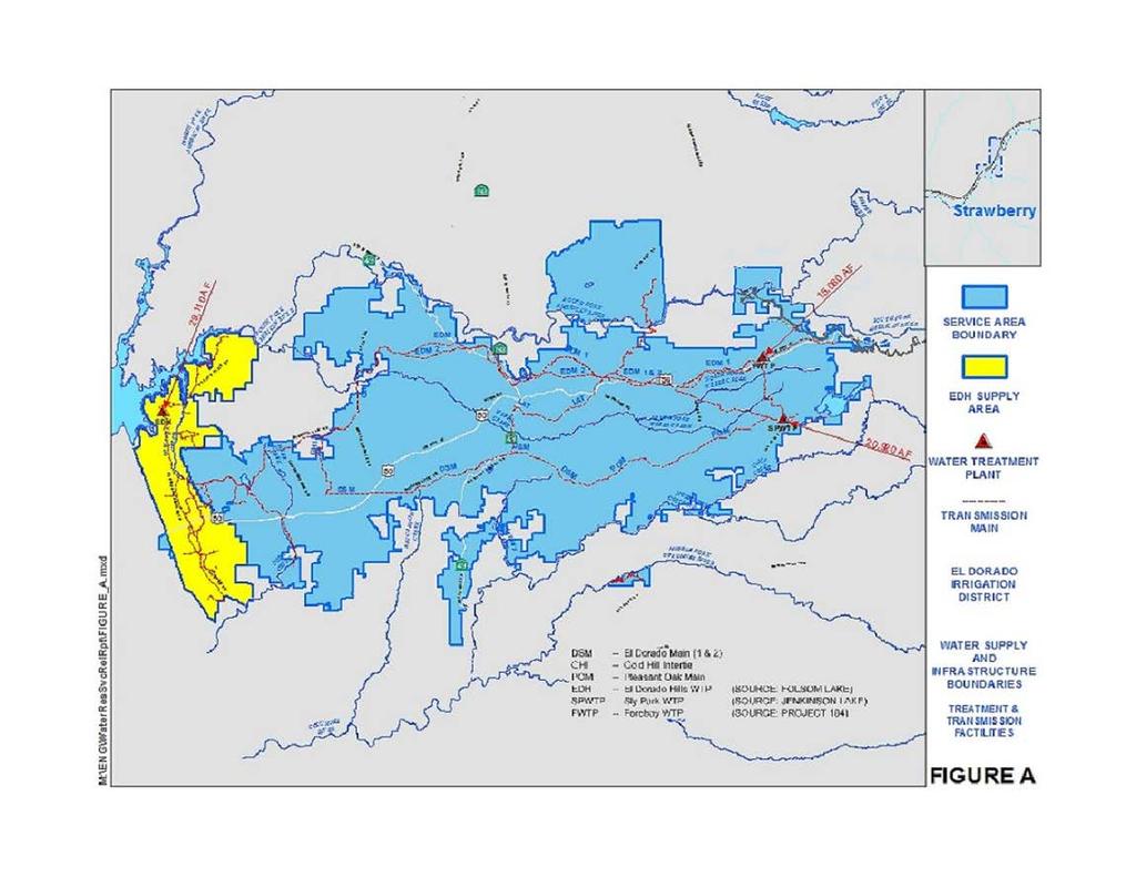
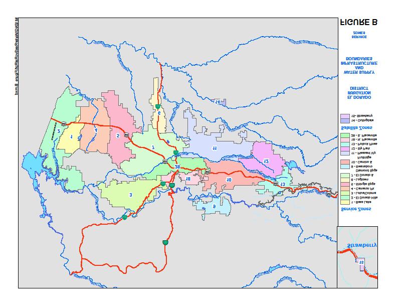
4 LIST OF TABLES TABLE 1 Water Meter Availability... 4 TABLE 2 System Firm Yield... 5 TABLE 3 Infrastructure Based Yield... 6 TABLE 4A Projected Demand, El Dorado Hills Supply Area... 7 TABLE 4B Projected Demand, Western/Eastern Supply Area... 8 TABLE 5 Active Demand, El Dorado Hills Supply Area... 9 TABLE 6 Latent Demand, El Dorado Hills Supply Area TABLE 7 Active Demand, Western/Eastern Supply Area TABLE 8A Western Latent Demand TABLE 8B Eastern Latent Demand TABLE 9 Other System Demand TABLE 10 Status of Commitments, El Dorado Hills Supply Area TABLE 11 Status of Commitments, Western/Eastern Supply Area TABLE 12 Active Demand, Recycled Water System TABLE 13 Latent Demand, Recycled Water System TABLE 14 Recycled Water Supply and Demand Summary TABLE 15 Projected Recycled Water Supply / Demand LIST OF FIGURES FIGURE A Water Supply and Infrastructure Boundaries... 2 FIGURE B Service Zones FIGURE C Recycled Water System APPENDICES APPENDIX A El Dorado Hills Historical Trends APPENDIX B Western Region Historical Trends APPENDIX C Eastern Region Historical Trends iii
5 This page intentionally left blank iv
6 1 EXECUTIVE SUMMARY The Water Resources and Service Reliability Report is updated annually to determine current water supply and water meter availability within the El Dorado Irrigation District (EID or District). Board Policy 5010, Water Supply Management, states that the District will not issue any new water meters if there is insufficient water supply. Administrative Regulation 5010, Water Availability and Commitments, outlines the responsibilities for annual reporting, shortages, and new meter restrictions. This policy and regulation provide the means to ensure that meter sales do not exceed water supply and infrastructure capacity. To determine the amount of water that will be available in the coming year for new meter sales, the District uses the firm yield of the water supply sources minus the total potential demand for all uses of this water. The District s overall system firm yield is approximately 63,500 acre-feet. For purposes of calculating meter availability for the District, two water supply areas have been identified, one that primarily receives water pumped from Folsom Reservoir, and one that receives water by gravity flow from the eastern supply sources Project 184 and Jenkinson Lake. The supply areas are divided into the El Dorado Hills supply area and the Western/Eastern supply area. The available supply in El Dorado Hills is currently restricted by infrastructure, which includes the capacity of the El Dorado Hills Water Treatment Plant and other conveyance facilities; whereas the supply in the Western/Eastern area is not restricted by infrastructure. The demands of the District have been divided into three regions: 1) El Dorado Hills; 2) Western Region, which includes the communities of Bass Lake, Cameron Park, Shingle Springs, Logtown, El Dorado and Diamond Springs; and 3) Eastern Region, which includes Pleasant Valley, Sly Park, Pollock Pines, Camino, Placerville, and Lotus/Coloma. Water customers in each region are then further sub-divided into user categories depending upon the type of use for the water, such as residential or commercial, turf or agricultural irrigation, or municipal delivery to the City of Placerville. A projected unit demand methodology was developed for the 2011 Report for all user categories in each demand region, and has been held constant through the 2013 Report. A new unit demand calculation will be included in next year s 2014 Report. ES-1
7 The following table reflects the current water meter availability for the District WATER METER AVAILABILITY EL DORADO HILLS SUPPLY AREA WESTERN/EASTERN SUPPLY AREA Water supply = 15,163 AF Water Supply = 36,000 AF Total Potential Demand = 11,554 AF Unallocated Water Supply = 3,609 AF Water Meter Availability = 4,687 EDUs Total Potential Demand = 34,955 AF Unallocated Water Supply = 1,045 AF Water Meter Availability = 1,935 EDUs This report also includes recycled water data, which is a valuable water resource for the District. The 2012 recycled water supply and demand data are presented, along with a projection of the 2013 recycled water supply and anticipated demands for either dry year or normal/wet year conditions. ES-2
8 2 SUMMARY OF WATER METER AVAILABILITY The water meter availability for EID is tracked within two distinct water supply areas; the El Dorado Hills supply area and the Western/Eastern supply area, which are illustrated in Figure A. The unallocated water supply is calculated as annual acre-feet (AF), and then converted to equivalent dwelling units (EDUs). 1 Table 1 summarizes the respective water meter availability for these two water supply areas. The subsequent Tables 2 through 9 are used to calculate the system firm yield and potential demand for both areas in order to determine the water meter availability. 2.1 El Dorado Hills Supply Area The available supply in the El Dorado Hills supply area is currently restricted by infrastructure, which includes the capacity of the El Dorado Hills Water Treatment Plant and other conveyance facilities. The water supply for the El Dorado Hills supply area is provided in Table 2. The active demand is provided in Table 5. Latent demand is shown in Tables 6, while other system demand is shown in Table 9. The resulting unallocated water supply for the year is provided in Table 1. To convert the available water supply to meter availability, an average unit demand was calculated based on actual historical demands. This per EDU demand was based on the average demands of single-family residential dwellings over a 10 year period between , with the high and low values removed to account for annual demand fluctuations. A new unit demand will be calculated for the 2014 Report. In each supply area, there are several contractual commitments that have been established. These commitments are further described in Section 6, Commitments. The District s system of water supply and infrastructure is adequate to serve these commitments in addition to a general pool of meter availability. 1 An EDU corresponds to a single-family residential dwelling served by a 3/4-inch water meter. Larger water meters, such as those for commercial applications, require additional EDUs. 1
9 2
10 2.2 Western / Eastern Supply Area The available supply in the Western / Eastern supply area is not restricted by infrastructure. The water supply for the Western / Eastern supply area is provided in Table 2. The active demand is provided in Table 7. Latent demand is shown in Tables 8A and 8B, while other system demand is shown in Table 9. The resulting unallocated water supply for the year is provided in Table 1. To convert the available water supply to meter availability, an average unit demand was calculated based on actual historical demands. This per EDU demand was based on the average demands of single-family residential dwellings over a 10 year period between , with the high and low values removed to account for annual demand fluctuations. A new unit demand will be calculated for the 2014 Report. The District also has contractual commitments within the Western/Eastern supply area from existing water supplies; these commitments are provided in Section 6, Commitments. The District s system of water supply and infrastructure is adequate to serve these commitments in addition to a general pool of meter availability. 2.3 Calculation of Water Meter Availability The following Tables 1 through 9 describe the system firm yield and calculate the potential demands of the two supply areas. Water meter availability is the difference between the available water supply and the total potential demand for each respective area. Total potential demand is the sum of active demand, latent demand, and other system demand. The active and latent demands have been determined using the average unit demands for each user category, multiplied by the number of active and latent accounts as of December 31 st of the previous year. The other system demand uses a fixed 13% loss rate applied to the infrastructure and supply yields, along with a 5-year historical average of recycled supplementation and other authorized uses. 3
11 TABLE 1 WATER METER AVAILABILITY EL DORADO HILLS SUPPLY AREA Infrastructure Based Yield from Folsom Reservoir (Table 3) 15,163 Acre-Feet Calculated Potential Demand Active Demand (Table 5) 8,602 Latent Demand (Table 6) 430 Other System Demand (Table 9) 2,522 Total Potential Demand 11,554 Acre-Feet 2013 Unallocated Water Supply 3,609 Acre-Feet Supply minus Total Potential Demand Conversion to Equivalent Dwelling Units (EDUs) 0.77 Acre-Feet Average EDU demand from 10-year historical per EDU data for single-family residential dwellings in the El Dorado Hills Supply Area. (Table 4A and Appendix Table A) 2013 Water Meter Availability 4,687 EDUs [1] [1] These EDUs are subject to the El Dorado Hills Contractual Commitments described in Section 6 and summarized in Table 10. WESTERN / EASTERN SUPPLY AREA Supply Based Yield of Eastern Sources (Table 2) 36,000 Acre-Feet Calculated Potential Demand Active Demand (Table 7) 28,090 Latent Demand (Tables 8A and 8B) 140 Other System Demand (Table 9) 6,725 Total Potential Demand 34,955 Acre-Feet 2013 Unallocated Water Supply 1,045 Acre-Feet Supply minus Total Potential Demand Conversion to Equivalent Dwelling Units (EDUs) 0.54 Acre-Feet Average EDU demand from 10-year historical data per EDU for single-family residential dwellings in the Western / Eastern Supply Area. (Table 4B, and Appendix Tables B and C) 2013 Water Meter Availability 1,935 EDUs [1] [1] These EDUs are subject to the Western / Eastern Contractual Commitments described in Section 6 and summarized in Table 11. 4
12 TABLE 2 SYSTEM FIRM YIELD El Dorado Hills and Western / Eastern Supply Areas OVERALL SYSTEM FIRM YIELD EID's System Firm Yield -No Infrastructure Restrictions- Determined using the OASIS Model [1] 63,500 Acre-Feet Supply from Folsom Reservoir EL DORADO HILLS SUPPLY AREA -No Infrastructure Restrictions- 29,110 Acre-Feet [2] El Dorado Hills Infrastructure Capacity and the Gold Hill Intertie 15,163 Acre-Feet [3] -Infrastructure Based Yield- WESTERN / EASTERN SUPPLY AREA Supply from Eastern Sources -No Infrastructure Restrictions- 36,000 Acre-Feet [4] Commercial [1] The OASIS Model is a computer software package developed by HydroLogics, Inc. to model hydrologic conditions in conjunction with certain input parameters. The OASIS Model determines the firm yield of the integrated system, which includes Project 184, Jenkinson Lake, Folsom USBR contracts, Permit and ditch/weber Reservoir water rights. The overall system firm yield determined by the OASIS Model is for planning level purposes. [2] The supply for the El Dorado Hills Area consists of 7,550 AF from the USBR Folsom Contract, 17,000 AF from Permit 21112, and 4,560 AF from ditch/weber water rights. The supply would be reduced in dry-years to approximately 25,660 AF to account for USBR cutbacks and reduced supply from the ditch/weber water rights. [3] The El Dorado Hills infrastructure capacity considers the capacity of the EDHWTP, the eastern transmission system, and the Gold Hill Intertie as determined in Table 3. [4] The supply for the Western / Eastern Supply Area consists of 15,080 AF from Project 184; and 20,920 AF from Jenkinson Lake. During a critical dry year, the annual supply from Jenkinson Lake would be reduced pursuant to Board Policy
13 TABLE 3 INFRASTRUCTURE BASED YIELD El Dorado Hills Supply Area EL DORADO HILLS WATER TREATMENT PLANT (EDHWTP) CAPACITY Calculation of Annual Acre-Feet Year Maximum Day WTP Capacity in MGD [1] Maximum Day Peaking Factor Calculated Average Day WTP Capacity in MGD Calculated Annual Acre-Feet ,563 GOLD HILL INTERTIE (GHI) CAPACITY Calculation of Annual Acre-Feet Year Available Maximum Day Capacity in GPM Maximum Day Peaking Factor Calculated Average Day Capacity in GPM Calculated Annual Acre-Feet TOTAL INFRASTRUCTURE BASED YIELD in Acre-Feet 15,163 6
14 User Categories EL DORADO HILLS SUPPLY AREA TABLE 4A PROJECTED 2013 DEMAND PER SERVICE El Dorado Hills Supply Area In Acre-Feet Demand per Service or Unit for the Previous 3-Years Average Unit Demand from 10-Year [1] Historical Trend Commercial Domestic Irrigation Multi-Family Residential (Units) Recreational Turf Services Single-Family Dual Potable Single-Family Residential Small Farm Irrigation SERVICE ZONES WITHIN SUPPLY AREA (Zone #): El Dorado Hills (02) [1] Refer to Appendix Table A for the historical data used to calculate the Average Unit Demands. 7
15 TABLE 4B PROJECTED 2013 DEMAND PER SERVICE Western / Eastern Supply Area In Acre-Feet User Categories Demand per Service or Unit for the Previous 3-Years Average Unit Demand from 10-Year [1] Historical Trend WESTERN REGION Agricultural Metered Irrigation Commercial Ditches Domestic Irrigation Multi-Family Residential (Units) Recreational Turf Services Single-Family Dual Potable Single-Family Residential Small Farm Irrigation EASTERN REGION Agricultural Metered Irrigation Commercial Ditches Domestic Irrigation Multi-Family Residential (Units) Municipal (City of Placerville) Recreational Turf Services Single-Family Residential Small Farm Irrigation SERVICE ZONES WITHIN SUPPLY AREA (Zone #): Western Region Bass Lake (01), Cameron Park (04), Shingle Springs (05), Logtown (06), Diamond Springs/El Dorado (07) Eastern Region Lotus/Coloma (03), Swansboro (09), Camino (10), Pleasant Valley (11), Sly Park (12), Pollock Pines (13), North Placerville (18), South Placerville (28) [1] Refer to Appendix Tables B and C for the historical data used to calculate the Average Unit Demands. 8
16 TABLE 5 ACTIVE DEMAND El Dorado Hills Supply Area ACTIVE DEMAND Average Demand from 2012 Services or Calculated Active Active Account Categories Historical Data AF per Service or Unit [1] Units Demand in AF Commercial ,427 Domestic Irrigation Mulit-Family Residential (Units) , Recreational Turf Services Single-Family Dual Potable , Single-Family Residential ,907 6,088 Small Farm Irrigation Calculated Active Acre-Feet 8,602 EL DORADO HILLS - ACTIVE DEMAND in Acre-Feet 8,602 [1] Refer to Appendix Table A for the historical data used to calculate the Average Unit Demands. 9
17 TABLE 6 LATENT DEMAND El Dorado Hills Supply Area INACTIVE ACCOUNTS Inactive Account Categories Average Demand from Historical Data AF per Service or Unit [1] 2012 Inactive Services or Units Calculated Inactive Demand in AF Single-Family Residential Single-Family Dual Potable Subtotal Inactive Acre-Feet 4 UNINSTALLED ACCOUNTS Uninstalled Meter Categories Average Demand from Historical Data AF per Service or Unit [1] 2012 Uninstalled Services or Units Calculated Uninstalled Demand in AF Commercial Single-Family Dual Potable Multi-Family Residential Single-Family Residential Subtotal Uninstalled Acre-Feet 426 Calculated Inactive and Uninstalled Acre-Feet 430 EL DORADO HILLS - LATENT DEMAND in Acre-Feet 430 [1] Refer to Appendix Table A for the historical data used to calculate the Average Unit Demands. 10
18 TABLE 7 ACTIVE DEMAND Western / Eastern Supply Area WESTERN ACTIVE DEMAND User Categories for Active Accounts Average Demand from Historical Data AF per Service or Unit [1] 2012 Services or Units Calculated Active Demand in AF Agricultural Metered Irrigation Commercial ,188 Ditches Domestic Irrigation ,122 Mulit-Family Residential (Units) , Recreational Turf Services Single-Family Dual Potable , Single-Family Residential ,589 8,289 Small Farm Irrigation Calculated WESTERN Active Acre-Feet 13,798 EASTERN ACTIVE DEMAND User Categories for Active Accounts Average Demand from Historical Data AF per Service or Unit [1] 2012 Services or Units Calculated Active Demand in AF Agricultural Metered Irrigation ,507 Commercial Ditches Domestic Irrigation Mulit-Family Residential (Units) , Municipal (City of Placerville) ,140 Recreational Turf Services Single-Family Residential ,451 4,064 Small Farm Irrigation Calculated EASTERN Active Acre-Feet 14,292 WESTERN / EASTERN - ACTIVE DEMAND in Acre-Feet 28,090 [1] Refer to Appendix Tables B and C for the historical data used to calculate the Average Unit Demands. 11
19 TABLE 8A WESTERN LATENT DEMAND Western / Eastern Supply Area WESTERN INACTIVE ACCOUNTS Inactive Account Categories Average Demand from Historical Data AF per Service or Unit [1] 2012 Services or Units Calculated Inactive Demand in AF Commercial Ditches Single-Family Dual Potable Single-Family Residential Subtotal WESTERN Inactive Acre-Feet 34 WESTERN UNINSTALLED ACCOUNTS Uninstalled Meter Categories Average Demand from Historical Data AF per Service or Unit [1] 2012 Uninstalled Services or Units Calculated Uninstalled Demand in AF Commercial Mulit-Family Residential (Units) Single-Family Dual Potable Single-Family Residential Subtotal WESTERN Uninstalled Acre-Feet 0 Calculated Inactive and Uninstalled Acre-Feet 34 WESTERN / EASTERN - LATENT DEMAND in Acre-Feet 34 [1] Refer to Appendix Tables B and C for the historical data used to calculate the Average Unit Demands. 12
20 TABLE 8B EASTERN LATENT DEMAND Western / Eastern Supply Area EASTERN INACTIVE ACCOUNTS Inactive Account Categories Average Demand from Historical Data AF per Service or Unit [1] 2012 Inactive Services or Units Calculated Inactive Demand in AF Agricultural Metered Irrigation Commercial Ditches Mulit-Family Residential (Units) Recreational Turf Services Single-Family Residential Subtotal EASTERN Inactive Acre-Feet 106 EASTERN UNINSTALLED ACCOUNTS Uninstalled Meter Categories Average Demand from Historical Data AF per Service or Unit [1] 2012 Uninstalled Services or Units Calculated Uninstalled Demand in AF Agricultural Metered Irrigation Commercial Single-Family Residential Subtotal EASTERN Uninstalled Acre-Feet 0 Calculated Inactive and Uninstalled Acre-Feet 106 EASTERN - LATENT DEMAND in Acre-Feet 106 [1] Refer to Appendix Tables B and C for the historical data used to calculate the Average Unit Demands. 13
21 TABLE 9 OTHER SYSTEM DEMAND El Dorado Hills and Western / Eastern Supply Areas In Acre-Feet OVERALL DISTRICT Overall System Firm Yield Historical Real and Apparent Losses (13%) [1] 5-Year Average Other Authorized Uses [2] 5-Year Average Recycled System Supplement Estimated Other System Demands 63,500 8,300 2, ,895 OVERALL - OTHER SYSTEM DEMAND in Acre-Feet 10,895 EL DORADO HILLS SUPPLY AREA El Dorado Hills Infrastructure Restricted Yield Historical Real and Apparent Losses (13%) [1] 5-Year Average Other Authorized Uses [2] 5-Year Average Recycled System Supplement Calculated Other System Demands 15,163 1, ,522 EL DORADO HILLS - OTHER SYSTEM DEMAND in Acre-Feet 2,522 WESTERN / EASTERN SUPPLY AREA Western / Eastern Supply Based Yield Historical Real and Apparent Losses (13%) [1] 5-Year Average Other Authorized Uses [2] 5-Year Average Recycled System Supplement Calculated Other System Demands 36,000 4,680 1, ,725 WESTERN / EASTERN - OTHER SYSTEM DEMAND in Acre-Feet 6,725 [1] The estimated real and apparent losses of 13% have been applied to the infrastructure and supply based yields for each supply area. [2] The other authorized uses have been distributed between the Western/Eastern and El Dorado Hills supply areas. 14
22 3 METHODOLOGY EL DORADO IRRIGATION DISTRICT The District has developed a method of reporting two numbers that are relevant to the availability of water supply: 1) a supply based yield; and 2) an infrastructure based yield. The supply based yield establishes water availability based on the hydrology of water rights, permits, and contracts that include Jenkinson Lake, Project 184, Permit 21112, and USBR Folsom contracts; while the infrastructure based yield establishes water availability based on the maximum day constraints of infrastructure. In a supply area such as El Dorado Hills, in which infrastructure like the water treatment plant capacity rather than water supply is the limiting factor in delivering water, the infrastructure based yield will be used to determine EDU availability. The meter sales in that supply area are limited to that which the infrastructure is currently capable of delivering on the maximum demand day of the year. The method used in this report distinguishes the EDU availability for El Dorado Hills versus the remainder of the District, while at the same time ensuring that EDU allocations overall do not outpace either infrastructure capacity or available water supplies. The OASIS modeling software was used to perform the firm yield modeling, based on historic hydrology. The model determines a supply based firm yield, which assumes that no infrastructure restrictions exist. This assumption provides the benefit of reporting a consistent firm yield number year after year, which only changes when additional supplies are added to the system. This number also gives the Board and the public a sense of the District s potential to deliver additional water as needed infrastructure projects are completed. It is also used to calculate meter availability in areas where water supply, rather than infrastructure, is the limiting factor. A separate calculation of infrastructure capacity was used to determine an infrastructure-based yield for the El Dorado Hills supply area. This calculation is accomplished by using the capacity of the El Dorado Hills Water Treatment Plant, plus a calculated capacity of the Gold Hill Intertie. This method compares maximum day demands against treatment and transmission capacities to determine meter availability for infrastructure-restricted areas such as El Dorado Hills. With the addition of 17,000 AF of Permit water and 4,560 AF from the Ditch/Weber water rights to the District s supplies, water availability from Folsom Reservoir is restricted by the El Dorado Hills water treatment plant capacity. In other words, there is more water supply available from Folsom Reservoir than this infrastructure can treat on a maximum day basis. By contrast, the District s Western/Eastern supply area is restricted by available supplies, not infrastructure. Infrastructure capacity exists to treat and deliver the annual allotment of Project 184 of 15,080 AF, and the approximate annual yield of Jenkinson Lake of 21,000 AF. Therefore, to fully account for these differing conditions within the District, the water supply yield has been divided into the following two supply areas: 15
23 1) El Dorado Hills supply area This area receives both water pumped from Folsom Lake combined with water provided by gravity flow from the Gold Hill Intertie (GHI). 2) Western/Eastern supply area This area includes the remaining higher elevation areas of the District that currently receive gravity water supply from the District s eastern sources - Project 184 and Jenkinson Lake. These two supply areas are shown in Figure A. This method provides an accurate way to analyze water availability that matches the capability and configuration of the District s water system. 3.1 EID Policies and Regulations Pertaining to EDU Allocations The District is governed by both Board Policies and Administrative Regulations that were developed in Board Policy 5010 Water Supply Management states that the District will not issue any new water meters if there is insufficient water supply. Administrative Regulation 5010 Water Availability and Commitments outlines the responsibilities for annual reporting, shortages, and new meter restrictions. This policy and regulation provide a means to ensure that meter sales do not exceed supply or infrastructure capacity. Board Policy 9020 Establishing New Service and Administrative Regulation 9021 Eligibility for New Service outline the process an applicant must comply with in order to purchase a water meter. As part of the application process for a project, an applicant must request a Facility Improvement Letter (FIL) from the District, which describes the existing system and any improvements that will be needed in order to receive service. For more complicated projects, the applicant must have a licensed engineer prepare a Facility Plan Report (FPR) for District review and approval. The FIL and FPR both assess the adequacy of the water system to provide service to the applicant and thereby identify the necessary improvements that must be constructed prior to the issuance of water meters. These facility improvements range from distribution facilities that must be funded and constructed by the developer, to District financed capital improvement projects such as transmission mains and storage tanks. The applicant can receive service only when the required facilities are completed and accepted by the District. These regulations and service procurement procedures, coupled with the guidelines in this report of meter availability, provide a solid basis to ensure that both adequate supply and infrastructure are in place to serve existing and new connections throughout the District. 16
24 4 SYSTEM FIRM YIELD ANALYSIS Table 2 summarizes the overall system firm yield of 63,500 AF as calculated by the OASIS computer model. This number represents an overall water demand that cannot be exceeded until new supplies are added. The overall system firm yield is then broken down into the two supply areas to calculate meter availability. The Folsom Reservoir supply is 29,110 AF, which includes the water service contract with the United States Bureau of Reclamation (USBR) for 7,550 AF, 17,000 AF Permit water rights, and a 4,560 AF Warren Act contract for the Ditch/Weber Reservoir water rights. The Western/Eastern supply is 36,000 AF, consisting of 15,080 AF from Project 184 and approximately 20,920 AF from Sly Park s Jenkinson Lake. 4.1 Water Rights Permit The State Water Resources Control Board (SWRCB) issued Water Right Permit to the District 1 on October 16, The District originally submitted an application for a multiple-year Warren Act Contract 2 (WAC) with the USBR for 11,000 AF of the 17,000 AF water right. The contract was then amended to 17,000 AF after the County General Plan was adopted. Prior to signing the previously negotiated 40-year Warren Act contract, the USBR must prepare an Environmental Assessment (EA) and make a Finding of No Significant Impact (FONSI) under the provisions of the National Environmental Policy Act (NEPA). The District is currently working with USBR to initiate formal consultation with National Oceanic and Atmospheric Administration (NOAA) fisheries under the Endangered Species Act. Over the last year staff has continued to coordinate with USBR staff to finalize the Permit Long-Term Warren Act Contract. The District s goal is to execute a contract in Rediversion of Existing Water Rights to Folsom Reservoir In the 1990s, the District began an initiative to convert ditch customers to the treated, piped system whenever feasible. The goal was to minimize the use of ditches in favor of the more efficient, less costly piped system. Over time, the District succeeded in removing all customers from the Summerfield Ditch, Gold Hill Ditch, and Farmers Free Ditch. Under California's water rights system, however, the District could maintain the water rights associated with these ditches only if it made a new beneficial use of the water supplies within five years of ceasing ditch operations. The District met this requirement by executing a series of one-year Warren Act Contracts with USBR. (The 1 The El Dorado Irrigation District and the El Dorado County Water Agency jointly submitted the application for diversion and consumptive use of the 17,000 acre-feet of water from FERC Project The execution of a Warren Act Contract, either single or multiple year, is required before a federal facility such as Folsom Reservoir can be used to store non-federal water. 17
25 Warren Act is a federal law that authorizes USBR to contract with others to use excess capacity in federal facilities to store or convey water belonging to others.) Under those one-year contracts, the District allowed the water formerly turned into these ditches to pass downstream to Folsom Reservoir, where the District withdrew it to supply service zones in the EI Dorado Hills area. In May 2004, the District moved to make this arrangement permanent by submitting an application for a long-term Warren Act Contract. Specifically, the District sought to introduce into Folsom Reservoir the waters of Slab Creek that were previously diverted into the Summerfield Ditch, the waters of Hangtown Creek that were previously diverted into the Gold Hill Ditch, and the waters of Weber Creek - both natural flows and stored releases from Weber Reservoir - that were previously diverted or re-diverted into the Farmers Free Ditch. The creek diversions are under rights that pre-date the Water Commission Act of 1914 and as such, are not under the jurisdiction of the State Water Resources Control Board (SWRCB). In contrast, the right to store water in Weber Reservoir is under license issued by the SWRCB, and therefore SWRCB approval was required to change the point of rediversion, place of use, and purposes of use to match the new operations. The District applied for this SWRCB approval in November 2004, and the SWRCB issued a revised water rights license to accommodate the new operations in October Meanwhile, the District and USBR negotiated language for the long-term contract and continued to execute successive one-year contracts. The District also completed the project's environmental review under California Environmental Quality Act (CEQA) in June USBR obtained federal Endangered Species Act clearances from the United States Fish and Wildlife Service in late 2009, and from the National Marine Fisheries Service in USBR also completed its environmental assessment under the National Environmental Policy Act (NEPA) in late 2009, and issued a NEPA Finding of No Significant Impact concurrent with approval of the contract. During much of this time, USBR's progress was slowed or halted by its involvement in numerous still-pending Endangered Species Act and NEPA lawsuits challenging USBR's operation of the Central Valley Project (of which Folsom Reservoir is a part). The long-term Warren Act Contract has a term of 40 years. The maximum contract amount is 4,560 acre-feet per year. This total reflects the best estimate of the yields of these various water rights in a normal water year, based upon limited actual data and computer modeling. The contract total also assumes a 15% conveyance loss between the former points of diversion and Folsom Reservoir. The actual total yield will vary from year to year, based on hydrologic conditions, but the amount taken in any year will be determined by the amount of water the District introduces into the reservoir. Unlike CVP contracts, this contract has no USBR-controlled shortage provisions. The assumed 15% conveyance loss can later be adjusted by mutual agreement, based on operational data, without amending the contract. The water is to be used for municipal and industrial (M&I) purposes in the EI Dorado Hills area. 18
26 4.3 Fazio Water Supply (Public Law ) On behalf of EID and Georgetown Divide Public Utility District (GDPUD), the El Dorado County Water Agency (EDCWA) is pursuing a water supply service contract with USBR. Public Law transferred unallocated Central Valley Project (CVP) supply to local water purveyors, allocating 15,000 acre-feet to El Dorado County. Under this new contract, up to 15,000 acre-feet of CVP M&I water would be made available for diversion from Folsom Reservoir, or from an exchange on the American River upstream from Folsom Reservoir between GDPUD and Placer County Water Agency. EDCWA would make this new CVP water available to EID and GDPUD for use within their respective service areas. P.L does not specify how much of the 15,000 acrefeet would be allocated to each district, however it has been tentatively assumed that the new CVP allocation would be split equally between EID and GDPUD. For EID, water would be diverted from the Folsom Lake intake and delivered to the El Dorado Hills and Cameron Park service areas. A Draft EIS/EIR was prepared by USBR and the EDCWA, and went out for public review and comment in EDCWA approved the Final EIR in January This final document is a CEQA-only Final EIR (but not a Final EIS). Because EDCWA was in a position to finalize the EIR portion of the draft joint document before USBR was in a position to finalize the EIS portion, EDCWA chose to prepare a CEQA only Final EIR in support of its decision to enter into a water supply contract with USBR, recognizing that USBR must prepare its own NEPA-only Final EIS before USBR can take action entering into such a contract with EDCWA. USBR has not yet completed its NEPA and Endangered Species Act (ESA) obligations due to ongoing Delta endangered species litigation related to its operation of the Central Valley Project. EDCWA continues explore with USBR alternatives to completing NEPA and ESA requirements so that a Record of Decision can be issued and a contract executed. When EDCWA and USBR ultimately execute a contract, the EDCWA would then execute subcontracts with EID and GDPUD. 4.4 Infrastructure Based Yield As previously noted, the El Dorado Hills supply area based yield is restricted by infrastructure. Significant improvements have been made to the El Dorado Hills water system infrastructure to support a capacity of 26 mgd. Based on this infrastructure capacity in combination with the capacity of the GHI, the total water supply for El Dorado Hills supply area has been calculated in the amount of 15,163 AF. This calculation is shown in Table 3, which uses the maximum day peaking factor of 2.0 from the District s design standards, along with the infrastructure capacity of the EDHWTP and GHI. 19
27 5 TOTAL POTENTIAL DEMAND The total potential demand has been calculated for each class of service using historical demands to determine an average unit demand. The highest and lowest annual demands from a 10 year period were excluded from the average. These values are held constant for a three-year period, including the 2013 Report, to avoid large EDU changes caused by annual demand fluctuations. A new unit demand calculation will be completed for next year s 2014 Report to account for more recent demand data. 5.1 Average Demand by User Category Tables 4A and 4B summarize the average demand per active meter for each user category over the last three years for the two designated supply areas of El Dorado Hills and Western/Eastern. The tables also show the average unit demand for each category. The user categories include: single-family and multi-family residential, single-family dual plumbed dwellings (potable), small farm irrigation, agricultural metered irrigation, ditches, recreational turf services, domestic irrigation, commercial/industrial, and municipal water sales to the City of Placerville. 5.2 Active Demand Table 5 summarizes the active demand for the El Dorado Hills supply area, and Table 7 the active demand for the Western/Eastern supply area. The active accounts, or dwelling units for multi-family, have been multiplied by the average unit demand for each user category from Tables 4A and 4B, respectively Active Accounts This category includes water meters that are installed in the ground, have an active billing status, and are charged a minimum bi-monthly billing regardless of recorded water use during the prior year. Pursuant to Article 3, Section of the California State Water Code, the Board of Directors adopted a policy on September 23, 1987 that requires all metered accounts to be billed from the date the water meter is installed. Therefore, any meters installed after 1987, or any meters that have changed ownership since 1987, are considered to be active accounts and are included in this category Active Meters Tables 4A and 4B summarize the average demand per service for the previous 3 years. Table 4A reports the average demand per service for the El Dorado Hills supply area; and Table 4B reports the average demand per service for the Western/Eastern supply area. In the case of multi-family residential, the projected unit demand is calculated per dwelling unit rather than per service to better represent the unit demands. 20
28 5.3 Latent Demand Table 6 summarizes the latent demand for the El Dorado Hills supply area, and Tables 8A and 8B summarize the latent demand for the Western/Eastern supply area. The latter area has been further separated into the Western and Eastern demand regions in order to more accurately calculate unit demands. Table 4B lists the individual service zones for these demand regions, and Figure B illustrates the service zones. The inactive accounts and uninstalled meters have been multiplied by the projected unit demand from the historical data for each user category from Tables 4A and 4B Inactive Accounts This category includes water meters that are installed in the ground but idle as of December 31 st of the previous year. This category also includes water meters purchased prior to 1987 that were then allowed to remain idle, and have had no changes in ownership or recorded water use since Uninstalled Meters This category includes water meters that have been purchased to serve a parcel of land, but have not yet been installed nor has an account been set up for minimum billing purposes. This category also includes those meters purchased under the Crawford Allocation during the declared Water Emergency in 1990, which are not required to be installed until needed. 5.4 Other System Demand Table 9 summarizes the other system demand for the El Dorado Hills supply area and the Western/Eastern supply area. The other system demand includes real losses of water into the ground due to leaks and breaks, apparent or paper losses such as meter inaccuracies, supplementation of potable water to the recycled system, and other authorized uses of water such as operational flushing or environmental flows. A fixed 13% rate for real and apparent losses has been applied to the available water supply, both infrastructure and supply based yields. This percentage of loss has been fairly consistent over the past 10 years, independent of annual diversions. Real and apparent losses are a major component of the calculation to determine the District s Other System Demand. Minor components include supplementation to the recycled system and other authorized uses. Five years of historical data are now available for these demands which allows for a 5-year average to be calculated in order to minimize yearly variations. 21
29 5.4.1 Authorized Uses The majority of authorized uses include potable water that is metered and billed to EID customers, and raw water that is both metered and unmetered, but billed to EID customers. Both of these categories are classified as revenue water and include not only the metered residential, commercial, and irrigation customers, but also private fire service connections and construction meters. In addition, EID receives assessments from Improvement District No. 97 metered raw water releases to Clear Creek for aesthetics flow maintenance; and the Knolls Reservoir Assessment District metered potable water releases for reservoir level maintenance. Authorized use of water also includes EID operational uses that are classified as nonrevenue water because they are unbilled, but include both metered and unmetered uses. Examples of non-revenue water would include water quality and operational flushing, reservoir operational overflows, water meter testing, and the flushing and cleaning of sewage lift stations and the sewage collection system Potable Water Supplement to Recycled System Potable water has been used to supplement the recycled water system since 2002 and is also included to calculate the District s Other System Demand in Table 9. Recycled water is used for residential and commercial landscape and turf irrigation. Several recycled water storage tanks and the Bass Lake pump station are the primary receiving points for supplemental potable water. With the closing of the Executive Golf Course, recycled water supplementation at the Highway 50 vault has been eliminated. It is usually necessary to make releases to these receiving points during the summertime but during peak demand periods. The potable water system will continue to supplement the recycled system unless and until additional recycled supply is available to meet recycled water demand. Refer to Section 7, Recycled Water System, for information regarding the recycled water supply and demand, plus projections of available supply and demand. 6 COMMITMENTS The District has several contractual commitments for water supply in both the El Dorado Hills and Western/Eastern supply areas. Below is a description of each of these commitments, along with their impact upon the District s existing and future water supplies. The methodology used in allocating EDUs under the board policies and administrative regulations ensures that the required infrastructure is built prior to the purchase of meters for the remaining commitments. Refer to Section 3.1, EID Policies and Regulations Pertaining to EDU Allocations, for a description of this governance. 22
30 6.1 El Dorado Hills Supply Area The contractual commitments for the El Dorado Hills supply area is provided in Table Assessment District No. 3 In May of 1985, Assessment District No. 3 (AD3) was formed as a means to finance expansions and improvements to the El Dorado Hills water and sewer systems and related facilities. 1 The ultimate capacity of AD3 was based on 9,074 annual AF of water supply because of the likelihood that EID would be able to contract for additional water supplies beyond the current (1985) contracted amount of 7,550 AF. Using 600 gallons per dwelling unit per day or 0.67 AF/year, 2 the 9,074 AF was estimated to support 13,543 dwelling units or the equivalent. 3 At the time AD3 was formed, EID was estimated to be serving or committed to serve 2,563 EDUs. Consequently, there was additional water capacity for approximately 10,980 EDUs Buy-ins to AD3 Subsequent buy-ins to AD3 were then allowed for both water and sewer service for parcels that were not participants in the original formation. In October of 1989, however, the District Board of Directors adopted Resolution No that revoked the ability of parcels to buy into AD3 for water service, until such time as the District determined that additional water supply was available to land already within the current boundaries of AD Monte Vista Parcels In April of 1994, the District Board of Directors took action to grandfather the existing parcels within the Monte Vista area into AD3 when this area was connected to the El Dorado Hills water system by a pipeline extension. This area had previously been served directly from Folsom Reservoir through a small water treatment plant. Water quality issues required EID to either upgrade the treatment plant or connect the Monte Vista water system to the El Dorado Hills system. The pipeline extension was the preferred solution and the connection was made Weber Dam Advanced Funding Agreement In December of 2000, the District entered into an Advanced Funding Agreement (AFA) 1 Tax Free Municipal Bonds, El Dorado Irrigation District, El Dorado County, California, Assessment District No. 3, Phase Two, Final Offering Statement dated May 30, From a 1981 EID water system analysis of El Dorado Hills. 3 The formation of AD3 was based on dwelling units, also known as equivalent dwelling units (EDUs). An EDU corresponds to a single-family residential dwelling served by a 3/4-inch water meter. Larger water meters, such as those for commercial applications, required additional EDUs. 23
31 with Serrano Associates LLC, Russell-Promontory LLC (AKT Development), El Dorado Hills Investors LTD, and Lennar Renaissance Inc., known in the agreement as the Interested Parties. These investors were willing to provide advanced funding of $4,000,000 to the District to reconstruct Weber Dam in exchange for the guarantee of 540 AF of water supply from existing District supplies. The water supply was to be used solely for and upon those properties owned by the Interested Parties, located within AD3, and that were annexed to EID on or before the effective date of the AFA. The District also made available under this agreement an additional 140 AF of existing water supply for individual parcels known as the Benefited Parties. These specific parcels were entitled to purchase water connections for their properties on a first-come, firstserved basis, consistent with District policies, procedures, and regulations. The Board approved a new agreement in February 2011 that provides a 10-year extension of the Interested Parties commitments Wetsel-Oviatt Agreement and Subsequent Amendment In September of 2003, the District entered into a Settlement Agreement with Wetsel- Oviatt, Inc., (Wetsel) which established a pool of 1,900 AF/yr of water supply available solely to Wetsel from new water sources, of which not less than 1,600 AF/yr would be potable water and the remainder would be recycled water. The new water supplies were defined as any water supply that increased the systemwide firm yield above 43,280 AF/yr; and the available water supplies to the El Dorado Hills region above 10,976 AF/yr. The new water supplies included Water Rights Permit for 17,000 AF/yr; the District s share of the prospective water service contract for 15,000 AF/yr contemplated by Public Law (Fazio Water); and the permanent transfer in point of diversion to Folsom Reservoir of the water rights associated with the District s Farmer s Free Ditch, Gold Hill Ditch, Summerfield Ditch, and Weber Reservoir. The new water supply that has been added to the system-wide firm yield found in Table 2 includes the 17,000 AF/yr from Permit and the Ditch/Weber water rights. With the expansion of the EDHWTP to 26 mgd, the new supplies made available from Folsom, taking into account infrastructure restrictions total 14,563 AF/yr. The incremental new water supply made available above 10,976 AF/yr is therefore 3,587 AF/yr. The agreement also states that for so long as the cumulative total of new water supplies is less than 3,800 AF/yr, then 50% shall be dedicated to the Wetsel pool and 50% shall become part of EID s generally available supplies. Accordingly, 1,794 AF/yr has been established for the Wetsel pool, consisting of 1,494 AF/yr of potable water and 300 AF/yr of recycled water. Therefore, the cumulative total potable water dedicated to the Wetsel pool is 1,494 AF. 24
32 2010 Amendment In 2010, The District and Sierra Pacific Industries (successor in interest to Wetsel- Oviatt) executed an amendment to the Wetsel-Oviatt Settlement Agreement. The amendment releases three-fourths of this contractual commitment, or 1,120 AF, through December 31, EID has established a pool of 1,494 acre-feet of potable water pursuant to the original Wetsel-Oviatt agreement. During the term of the amendment, SPI shall be eligible to purchase service connections for only 25% of the amount of potable water supplies in the pool established by EID, or 374 acre-feet Carson Creek Agreement In December of 2007, the District entered into an agreement with AKT Carson Creek Investors, LLC for provision of services and advance partial purchase of Facility Capacity Charges (FCCs). Under the agreement, AKT Carson Creek Investors, LLC made an advance deposit of $4,337,500 against future FCC liability. In exchange, the District provided assurance of future water, recycled water, and wastewater service for up to 1,250 dual-plumbed residential units. The agreement benefited the District financially by smoothing the dramatic fluctuation in FCC revenues the District would otherwise experience. The agreement benefited the developer of the property by making the property eligible to purchase service, as available, on a par with the beneficiaries of other contractual commitments. 25
33 TABLE 10 STATUS OF COMMITMENTS El Dorado Hills Supply Area EQUIVALENT DWELLING UNITS (EDUs) Type of Commitment Zone Original Commitments EDUs Sold or Expired Remainder of Commitments Zone 1 and/or 2 [1] Considered in the Formation of AD3 Existing Dwelling Units - 2,563 1, 2 13,543 12,177 1,366 New Dwelling Units - 10,980 Buy-ins Allowed to AD Monte Vista Parcels Advanced Funding Agreement 1, 2 1, Zone Total Potable Commitment Current Potable commitment (AF) Reduced per amendment (AF) Wetsel-Oviatt Agreement [2] [3] 2 1,737 1, EDU commitment 485 Zone Dual-plumbed homes Dual Plumbed Unit Demand Ratio EDU commitment Carson Creek Agreement [4] 2 1,250 1 EDU = 2.5 homes 500 TOTAL EDU COMMITMENTS 2,690 EL DORADO HILLS COMMITMENTS in EDUs 2,690 [1] Zone 2 is the El Dorado Hills Service Zone. Zone 1 is the Bass Lake Service Zone. [2] This commitment is conditional upon certain augmentations to the District's water supply. With increases in supply to EDH, 1,494 AF of potable water has been assigned to this pool. [3] Per Amendment 1 to the Wetsel-Oviatt Settlement Agreement, dated March 12, 2010, 75% of the water supply has been released through December 31, [4] This agreement secured 1,250 dual-plumbed residential units for the Carson Creek property. 26
34 6.2 Western / Eastern Supply Area The total contractual commitments for the Western/Eastern supply area is provided in Table Apple Mountain In April of 2001, the District entered into a Water Service Agreement with Apple Mountain, LP for property known as the Apple Mountain Golf Course. The District committed to provide up to 270 AF/yr of water for golf course irrigation and non-potable uses. The annual amount is further restricted with no more than 240 AF between May 15 and October 15; and no more than 60 AF in each of the months of July and August. The golf course's highest annual use was 197 Acre-Feet and is included as an Agricultural Metered Irrigation account, therefore approximately 73 Acre-Feet remain to be committed. The Average Unit Demand projection of 0.42 AF/YR for the Eastern Region (Table 4B) has been used to make the conversion. (73/0.42 = 174 EDUs) Bell Ranch In June of 2002, the District entered into a Settlement Agreement with Bell Ranch Properties, LTD in order to acquire approximately 4.83 acres of Bell Ranch Property for the purpose of constructing the Bass Lake water storage tanks. The Bass Lake Tanks project is part of the District s distribution system for potable water that serves portions of the Cameron Park and Bass Lake areas. In exchange for the 4.83 acres of land, the District guaranteed, from existing supplies, 113 water and sewer connections, subject to terms and conditions, annexation of Bell Ranch property, and payment of all Facility Connection Charges (FCCs) and fees in effect at the time application for service is made. 27
35 TABLE 11 STATUS OF COMMITMENTS Western / Eastern Supply Area COMMITMENTS - EQUIVALENT DWELLING UNITS (EDUs) Type of Commitment Zone Original Commitments EDUs Sold Remainder of Commitments Bell Ranch Settlement Agreement Sub-Total 113 Zone Original Commitment (AF) Highest Amount Used (AF) Remaining Commitment (AF) Converted to EDUs Apple Mountain Water Service Agreement TOTAL COMMITMENTS in EDUs 283 WESTERN / EASTERN COMMITMENTS in EDUs
36 29
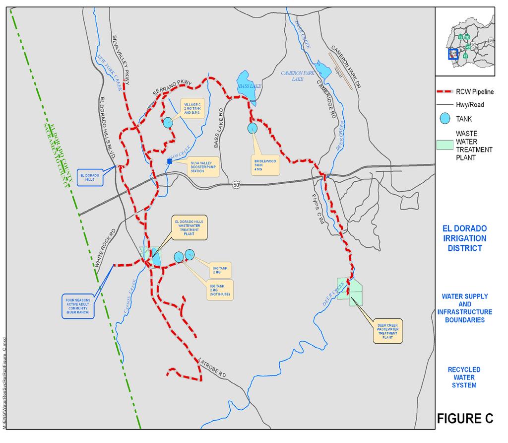
37 7 RECYCLED WATER SYSTEM A summary of the recycled water supply for the District has been included in the water supply and demand reporting since The following sections document the current and projected recycled water supply and demand data for the District. 7.1 Supply and Demand Summary The total recycled water supply includes supply from the El Dorado Hills Wastewater Treatment Plant (EDHWWTP), the Deer Creek Wastewater Treatment Plant (DCWWTP), and direct potable supplementation to the recycled system. Refer to Table Supply The supply to the recycled water system is dependent upon wastewater treatment plant influent flow and storage. The sources of recycled supply include: 1) the EDHWWTP influent and storage; 2) the DCWWTP influent; and 3) points of direct potable water supplementation, including Bass Lake. The WWTP sources provide supply through facilities that were built in accordance with the Water Reclamation Master Plan. The location of these facilities is illustrated in Figure C Demand The demand for recycled water is based upon the actual usage of active meters as of December 31 st of the previous year. The total potential demand includes the active demand (Table 12), plus a calculated demand for inactive accounts and uninstalled recycled water meters (Table 13). 7.2 Projected Recycled Water Supply and Demand The deficit of recycled water demand will be met by potable water supplementation until additional recycled water supply is available. Table 15 contains a summary of the projected supply and demand. 30
38 TABLE ACTIVE DEMAND Recycled Water System ACTIVE DEMANDS Active Account Categories 2012 Active Services 2012 Demand in Acre-Feet Acre-Feet per service Commercial / Industrial Recycled [1] Recreational Turf Recycled [2] Single-Family Dual Recycled 3,918 1, TOTALS 4,077 2, [1] The Commercial / Industrial Recycled accounts include outside irrigation of commercial landscaping and street medians. [2] The Recreational Turf Recycled accounts serve publicly or privately owned property that may accommodate organized recreational activities, and for which the primary use of the recycled water is for turf irrigation and associated landscaping (i.e. parks, ball fields, and school turf). 31
39 TABLE LATENT DEMAND Recycled Water System INACTIVE ACCOUNTS Inactive Account Categories 2012 Demand Acre-Feet per Account 2012 Inactive Accounts Calculated Inactive Demand in Acre-Feet Commercial / Industrial Recycled Single-Family Dual Recycled Subtotal Inactive Acre-Feet 0 UNINSTALLED METERS Uninstalled Meter Categories 2012 Demand Acre-Feet per Meter 2012 Uninstalled Meters Calculated Uninstalled Demand in Acre-Feet Commercial / Industrial Recycled Single-Family Dual Recycled Subtotal Uninstalled Acre-Feet 212 Calculated Inactive and Uninstalled Acre-Feet 212 RECYCLED WATER SYSTEM - LATENT DEMAND in Acre-Feet
40 TABLE SUPPLY and DEMAND SUMMARY Recycled Water System In Acre-Feet 2012 SUPPLY Wastewater Treatment Plant Supply [1] Reservoir Storage Supply El Dorado Hills Deer Creek El Dorado Hills [2] Bass Lake [3] Direct Potable Supplementation to Recycled System [4] TOTAL SUPPLY 1, , DEMAND ACTIVE DEMAND LATENT DEMAND Authorized Metered and Billed Authorized Unbilled Uses [5] TOTAL Inactive Uninstalled TOTAL 2, , REAL AND APPARENT LOSSES Total 2012 Supply Total 2012 Active Demand 2012 Real and Apparent Losses 3,000 2,994 6 [1] Data from actual total 2012 readings from WWTP plants. [2] The 224 acre-feet (73 MG) of storage is the revised reservoir capacity, with the actual supply used from storage being included in the El Dorado Hills Wastewater Treatment Plant supply of 1,521 acre-feet. [3] Actual raw water supply that was pumped out of Bass Lake Reservoir into the recycled water system. 700 AF available. [4] Direct supplementation includes potable water supplied in 2012 to the 940, Bridlewood, and Village C recycled water storage tanks, and to the Serrano Golf Course. [5] Operational changes in late plant water now is pumped internally prior to effluent flow meter. Not a recorded demand. 33
41 TABLE 15 PROJECTED 2013 SUPPLY and DEMAND Recycled Water System In Acre-Feet SUPPLY PROJECTIONS FOR 2013 SUPPLY YEAR Treatment Plant Supply Reservoir Storage Supply El Dorado Hills Deer Creek El Dorado Hills [3] Bass Lake [4] TOTAL SUPPLY 2013 Projected Supply [1] 1, ,415 DEMAND PROJECTIONS FOR 2013 TYPE OF DEMAND YEAR Filter Backwash Water WWTP Irrigation & Operational [6] Uses Delivered to Distribution System TOTAL DEMAND [5] Projected 2013 Normal/Wet Year [2A] ,899 3,040 Projected 2013 Dry Year [2B] ,450 3,618 [1] Data from actual total 2012 readings from WWTP plants, plus 0.5% for growth in WWTP supply. [2A] [2B] Source for the 2013 projected demands is the annual water balance prepared by District engineering staff. [3] The 224 acre-feet (73 mg) of storage is the revised capacity for the reservoir at the El Dorado Hills Wastewater Treatment Plant. It is an internal supply and included in the EDHWWTP Totals [4] Bass Lake has 700 acre-feet of storage reserved for emergency use and therefore is not considered in total projected supply. [5] The demand that cannot currently be met by recycled water will be met by supplementation from the potable water system. [6] Operational Change in All Operational water taken off system prior to recycled water effluent meter. 34
42 35
2016 WATER RESOURCES SERVICE RELIABILITY REPORT AND. El Dorado Irrigation District 2890 Mosquito Road Placerville, California 95667
 2016 WATER RESOURCES AND SERVICE RELIABILITY REPORT El Dorado Irrigation District 2890 Mosquito Road Placerville, California 95667 Presented to the EID Board of Directors September 12, 2016 This page intentionally
EXISTING EID WATER SUPPLY SOURCES
 EXISTING EID WATER SUPPLY SOURCES FOLSOM RESERVOIR Folsom Reservoir is located at the west end of El Dorado County, at the confluence of the North and South Forks of the American River. EID treats water
Update to Facility Capacity Charges Methodology and Schedule. A study for El Dorado Irrigation District. prepared by. Bartle Wells Associates
 APPENDIX A Update to Facility Capacity Charges Methodology and Schedule A study for El Dorado Irrigation District prepared by Bartle Wells Associates Principal Consultants Doug Dove, President Catherine
Integrated Water Resources Master Plan
 Integrated Water Resources Master Plan El Dorado Irrigation District March 31, 2013 Robert H. Ellis NO. 24676 EXP. 12/31/13 Holly Kennedy NO. 74682 EXP. 12/31/13 Prepared under the responsible charge of
El Dorado Water & Power Authority. El Dorado Water Reliability Project
 El Dorado Water & Power Authority 1 WELCOME El Dorado Water Reliability Project EIR SCOPING MEETING El Dorado Water & Power Authority is implementing the El Dorado Water Reliability Project as a component
EL DORADO COUNTY GENERAL PLAN PUBLIC SERVICES AND UTILITIES ELEMENT PRINCIPLE INTRODUCTION RELATIONSHIP TO OTHER ELEMENTS
 EL DORADO COUNTY GENERAL PLAN PUBLIC SERVICES AND UTILITIES ELEMENT PRINCIPLE The Plan must identify the types of governmental services which are necessary to meet residents needs and provide a fiscally
3 RELATED PLANS, AGREEMENTS, AND POLICIES
 3 RELATED PLANS, AGREEMENTS, AND POLICIES The District s process of water delivery to its customers has been developed over many years in the context of various agreements, plans, and policies that address
Engineer s Report. Santa Clara Valley Water District California Aqueduct Reverse Flow Project Project No
 17 Santa Clara Valley Water District California Aqueduct Reverse Flow Project Project No. 60061007-6810 Engineer s Report February 2015 Water Utility Capital Division This page intentionally left blank.
City of Roseville General Plan 2035, as amended June 2016 (City of Roseville 2016a)
") 4.7 WATER SUPPLY 4.7.1 INTRODUCTION This section evaluates potential impacts associated with demand for water supply associated with implementation of the VillaSport Athletic Club and Spa Project (proposed
4.7 WATER SUPPLY 4.7.1 INTRODUCTION This section evaluates potential impacts associated with demand for water supply associated with implementation of the VillaSport Athletic Club and Spa Project (proposed
Water and Power Policy Group
 Water and Power Policy Group Retrospective Analysis of Changed Central Valley Project and State Water Project Conditions Due to Changes in Delta Regulations January 213 Retrospective Analysis January 213
20. UTILITIES AND SERVICE SYSTEMS
 June 28, 2018 Page 20-1 20. UTILITIES AND SERVICE SYSTEMS This EIR chapter describes existing conditions for and distribution, collection and, and solid waste disposal and recycling in the planning area.
Raw water sources, facilities, and infrastructure
 WATER AND WASTEWATER SERVICES IN STEAMBOAT SPRINGS Prepared by Jay Gallagher, General Manager Mt. Werner Water and Sanitation District (February, 2015) Raw water sources, facilities, and infrastructure
BAWSCA-EBMUD Short-Term Pilot Water Transfer Plan. September 2013
 BAWSCA-EBMUD Short-Term Pilot Water Transfer Plan BAWSCA-EBMUD Short-Term Pilot Water Transfer Plan Executive Summary Prepared by: Bay Area Water Supply and Conservation Agency East Bay Municipal Utility
Amendment to EBMUD Retirement System Ordinance (No. 40) - Section 21 First Reading. Board of Directors March 10, 2015
 - Section 21 First Reading. Board of Directors March 10, 2015") Amendment to EBMUD Retirement System Ordinance (No. 40) - Section 21 First Reading Board of Directors March 10, 2015 Updates to Ordinance No. 40 Section 21 provides for an optional modification of a member
Amendment to EBMUD Retirement System Ordinance (No. 40) - Section 21 First Reading Board of Directors March 10, 2015 Updates to Ordinance No. 40 Section 21 provides for an optional modification of a member
CHAPTER 2 Water Demands
 CHAPTER 2 Water Demands This chapter provides an overview of the City s water service area and describes the City s historical annual water use. Subsequent sections of this chapter examine projected water
EID declares Stage 2 drought emergency
 Friday, February 7, 2014 PLACERVILLE, CALIFORNIA 99 CENTS EID declares Stage 2 drought emergency JENKINSON LAKE at Sly Park is 64 percent of capacity as of Feb. 6. Had EID not imported water from the El
El Dorado Irrigation District. Integrated Water Resources Master Plan
 El Dorado Irrigation District Integrated Water Resources Master Plan July 2013 El Dorado Irrigation District July 31, 2013 Holly Kennedy NO. 74682 EXP. 12/31/13 Prepared under the responsible charge of
Contents 8/31/2017 DRAFT REGIONAL IMPACT FEE FACILITIES PLAN & ANALYSIS
 Contents Executive Summary... 2 Introduction... 2 Impact Fee Facilities Plan and Impact Fee Analysis... 2 Level of Service... 2 Excess Capacity Used by New Development... 3 Building Facilities for New
4.n. 07/12/2007. Wayne M. Fowler, Sr. Local Government Analyst
 4.n. 07/12/2007 TO: FROM: SUBJECT: Local Agency Formation Commission Wayne M. Fowler, Sr. Local Government Analyst LAFCO 2007-13-4 MINOR SPHERE OF INFLUENCE AMENDMENT (addition) TO THE CITY OF BLYTHE AND
APPENDIX E PROJECT EVALUATION SUMMARY TABLE
 APPENDIX E PROJECT EVALUATION SUMMARY TABLE This page left blank intentionally. Table of Contents E.1 INTRODUCTION... E-1 E.2 SURFACE WATER STORAGE SWRP COMPONENT EVALUATION SUMMARY... E-7 E.3 WATERSHED
CHAPTER 3 Water Supply
 CHAPTER 3 3.1 WATER SUPPLY OVERVIEW This chapter describes the sources of water available to the City and MID. The chapter includes a description of each water source, including limitations, water quality
3. Water Rights Inventory
 3. Water Rights Inventory 3.1 Current Water Rights Portfolio The City s water supply is derived from the Big Thompson River pursuant to water rights for the native supply and contracts for transmountain
4.21 WASTEWATER DISPOSAL
 4.21 WASTEWATER DISPOSAL 1. SUMMARY The proposed project includes a wastewater reclamation plant (WRP), which would be owned and operated by the City of Santa Clarita and recycle up to 395,411 gallons
MOUNTAIN HOUSE SPECIFIC PLAN II
 CHAPTER TWELVE: POTABLE WATER 12.1 INTRODUCTION 12.1 12.2 POTABLE WATER SUPPLY 12.1 12.3 POTABLE WATER DEMAND 12.2 12.4 WATER CONSERVATION 12.7 12.5 BBID SERVICE TO INTERIM AGRICULTURAL OPERATIONS 12.8
4 PLANNING DATA AND WATER DEMAND FORECASTING
 4 PLANNING DATA AND WATER DEMAND FORECASTING This chapter discusses the planning data and water demand forecast information used to assess the current and future capabilities of the District s water system.
APPENDIX A NOTICE OF PREPARATION/ NOTICE OF INTENT. Proposed Lower Yuba River Accord June 2007 Draft EIR/EIS
 APPENDIX A NOTICE OF PREPARATION/ NOTICE OF INTENT Proposed Lower Yuba River Accord June 2007 Draft EIR/EIS Proposed Lower Yuba River Accord June 2007 Draft EIR/EIS Interested Parties NOTICE OF PREPARATION
MOUNTAIN HOUSE MASTER PLAN CHAPTER THIRTEEN WASTEWATER TREATMENT AND COLLECTION SYSTEM
 CHAPTER THIRTEEN WASTEWATER TREATMENT AND COLLECTION SYSTEM CHAPTER THIRTEEN: WASTEWATER TREATMENT AND COLLECTION SYSTEM 13.1 INTRODUCTION 13.1 13.2 ASSUMPTIONS 13.1 13.3 WASTEWATER GENERATION 13.1 13.4
CITY OF PRESCOTT WATER MANAGEMENT POLICY
 CITY OF PRESCOTT WATER MANAGEMENT POLICY 2005-2010 APPROVED BY PRESCOTT CITY COUNCIL OCTOBER 25, 2005 RESOLUTION #3712 AMENDMENT #1 MARCH 27, 2007 RESOLUTION #3807 INTRODUCTION AND BACKGROUND The City
4.16 UTILITIES AND SERVICE SYSTEMS
 4.16 UTILITIES AND SERVICE SYSTEMS This section evaluates the effects of the proposed project with regard to utilities and service systems by identifying anticipated demand and existing and planned utility
6.13 Utilities and Service Systems
 6.13 6.13.1 Introduction This section describes impacts for utilities and service systems that would result from construction and operation of the CEQA Alternatives. 6.13.2 Regulatory Setting There are
SECTION 5.15 Wastewater
 SECTION 5.15 Wastewater 5.15 WASTEWATER This section addresses the impacts of the proposed project on wastewater conveyance and treatment facilities. The analysis identifies the service area the project
Administrative Final 1
 1 For the (ARWA), we appreciate the opportunity to comment on the final environmental impact report/environmental impact statement (FEIR/EIS) for the California WaterFix project. These agencies rely, in
WASTEWATER INTRODUCTION ENVIRONMENTAL SETTING
 3.14.4 WASTEWATER INTRODUCTION This section of the Draft EIR describes the wastewater disposal conditions in the area surrounding the project site. The analysis focuses on potential impacts to wastewater
Section V: Water Accounting and Water Supply Reliability
 Section V: Water Accounting and Water Reliability A. Quantifying the Water Supplier s Water Supplies 1. Agricultural Water Supplier Water Quantities Table 41 shows typical water diversions from the CA
Section V: Water Accounting and Water Supply Reliability
 Section V: Accounting and Supply Reliability A. Quantifying the Supplier s Supplies 1. Agricultural Supplier Quantities Table 38 shows typical water diversions from the CA Aqueduct during the representative
SACRAMENTO LOCAL AGENCY FORMATION COMMISSION 1112 I Street, Suite #100 Sacramento, California (916) August 3, 2005
 August 3, 2005") SACRAMENTO LOCAL AGENCY FORMATION COMMISSION 1112 I Street, Suite #100 Sacramento, California 95814 (916) 874-6458 August 3, 2005 TO: FROM: RE: Sacramento Local Agency Formation Commission Peter Brundage,
SACRAMENTO LOCAL AGENCY FORMATION COMMISSION 1112 I Street, Suite #100 Sacramento, California 95814 (916) 874-6458 August 3, 2005 TO: FROM: RE: Sacramento Local Agency Formation Commission Peter Brundage,
CITY OF ROSEBURG LONG-RANGE WATER SUPPLY PLAN
 FILE COpy CITY OF ROSEBURG LONG-RANGE WATER SUPPLY PLAN Project No. 06WA23 July 2009 In Association With: LONG-RANGE WATER SUPPLY PLAN FOR CITY OF ROSEBURG, OREGON JULY 2009 Expires 613012010 Prepared
Hollister Urban Area Water and Wastewater Master Plan Update
 Hollister Urban Area Water and Wastewater Master Plan Update City of Hollister, San Benito County Water District, and Sunnyslope County Water District June 2017 Robert H. Ellis NO. 24679 EXP. 12/31/17
APPENDIX C 2012 RECYCLED WATER FEASIBILITY STUDY PUBLIC COMMENT RESPONSES
 APPENDIX C 2012 RECYCLED WATER FEASIBILITY STUDY PUBLIC COMMENT RESPONSES Prepared by: Dennis Delzeit, P.E., Project Manager Reviewed by: Tom Falk, P.E., Dudek Date: April 26, 2012 1. Can the treated effluent
MUNICIPAL AND INDUSTRIAL WATER SHORTAGE POLICY CENTRAL VALLEY PROJECT, CALIFORNIA Environmental Assessment
 MUNICIPAL AND INDUSTRIAL WATER SHORTAGE POLICY CENTRAL VALLEY PROJECT, CALIFORNIA Environmental Assessment October 2005 Table of Contents Items Page CHAPTER 1 PURPOSE AND NEED Introduction...1-1 Background
WATER AND WASTEWATER RATE STUDY
 WATER AND WASTEWATER RATE STUDY B&V PROJECT NO. 176244.0100 PREPARED FOR Camrosa Water District MARCH 20, 2013 Black & Veatch Holding Company 2011. All rights reserved. Camrosa Water District WATER AND
CHAPTER TWELVE: POTABLE WATER
 CHAPTER TWELVE: POTABLE WATER 12.1 Introduction This chapter summarizes Master Plan provisions related to the potable water system and states the plan description and implementation measures for Specific
FLORIDA STATE UNIVERSITY MASTER PLAN 9 General Infrastructure
 GENERAL INFRASTRUCTURE ELEMENT NOTE: Unless otherwise noted, the goals, objectives and policies contained in this element shall guide development of the Main Campus and Southwest Campus in Tallahassee
Committee on Water. Desalination as a Water Source
 Committee on Water Committee on Water Desalination as a Water Source Water Supply Reliability for San Diego County NARUC Summer Policy Summit July 17, 2017 Bob Yamada Director of Water Resources San Diego
Section Water Supply Element
 3.3.2. Water 4-2-12 Section 3.3.2. Water Supply Element Pursuant to Sections 163.3167, 163.3177, and 163.318 Florida Statutes and Chapter 9J-5.011(2) of the Florida Administrative Code. Background Discussion
Yale Hydroelectric Project FERC Project No APPLICATION FOR NEW LICENSE FOR MAJOR PROJECT Volume I
 APPLICATION FOR NEW LICENSE FOR MAJOR PROJECT Volume I Executive Summary Initial Statement Exhibit A - Description of the Project Exhibit B - Project Operation and Resource Utilization Exhibit C - Construction
EL DORADO COUNTY REGIONAL FIRE PROTECTION STANDARD
 EL DORADO COUNTY REGIONAL FIRE PROTECTION STANDARD Fire Water Supply without a Purveyor Residential & Commercial STANDARD #D-003 EFFECTIVE 01-04-2016 1. PURPOSE 1.1. The California Fire Code (CFC) requires
Overview of Local Facilities. Integrated Resource Planning Advisory Committee
 Overview of Local Facilities Integrated Resource Planning Advisory Committee City of Henderson Utility Services System Overview 2 CITY OF HENDERSON Department of Utility Services The Department of Utility
Subject: Notice of Preparation of a Draft Environmental Impact Report for the El Dorado Water Reliability Project
 4330 Golden Center Drive, Suite C Placerville, CA 95667 Tel 530.621.5392 Fax 530.672.6721 https://www.edcgov.us/waterandpower/index.html December 22, 2017 Subject: of a Draft Environmental Impact Report
Los Vaqueros Reservoir Expansion Investigation Update on Draft Feasibility Report and State Funding Application
 Los Vaqueros Reservoir Expansion Investigation Update on Draft Feasibility Report and State Funding Application February 22, 2018 Los Vaqueros Reservoir Off-stream storage facility currently served by
Meeting Agenda. 6:00 P.M. Welcome and Introductions Dan Corcoran, EID Environmental Manager
 Meeting Agenda 6:00 P.M. Welcome and Introductions Dan Corcoran, EID Environmental Manager 6:05 P.M. How to get involved in the process What to expect from this evening s meeting Kristin Schaeffer, EID
Chapter 8 National Economic Development and Locally Preferred Alternative
 Chapter 8 National Economic Development and Locally Preferred Alternative Determination of Feasibility This chapter considers the feasibility of the NED Plan and the Locally Preferred Alternative. As indicated
Section V: Water Accounting and Water Supply Reliability
 Section V: Accounting and Supply Reliability A. Quantifying the Supplier s Supplies 1. Agricultural Supplier Quantities Table 46 illustrate the District s water. The District routinely transfers and/or
CONTRA COSTA LOCAL AGENCY FORMATION COMMISSION EXECUTIVE OFFICER'S REPORT July 12, 2017 (Agenda)
") CONTRA COSTA LOCAL AGENCY FORMATION COMMISSION EXECUTIVE OFFICER'S REPORT July 12, 2017 (Agenda) LAFCO 14-01 APPLICANT ACREAGE & LOCATION PURPOSE Sphere of Influence Amendment Contra Costa Water District
CONTRA COSTA LOCAL AGENCY FORMATION COMMISSION EXECUTIVE OFFICER'S REPORT July 12, 2017 (Agenda) LAFCO 14-01 APPLICANT ACREAGE & LOCATION PURPOSE Sphere of Influence Amendment Contra Costa Water District
The Path to 2060: Dallas Water Plan Update Reuse Partnership with North Texas Municipal Water District
 The Path to 2060: Dallas Water Plan Update Reuse Partnership with North Texas Municipal Water District The State s 16 Regional Planning areas are identified by the letters A to P. Dallas is in Region C.
Analysis of Proposed Water Sale Agreement Between Sabine River Authority, State of Louisiana and Toledo Bend Partners, LP
 Analysis of Proposed Water Sale Agreement Between Sabine River Authority, State of Louisiana and Toledo Bend Partners, LP Pursuant to La. R.S. 38:2325(16), the Sabine River Authority of Louisiana ( SRA-LA
Agenda Item #4 Attachment C Page 1 of 6
 PLAN OF SERVICE LA CANADA SUBDIVION ANNEXATION TO THE EL DORADO IRRIGATION DISTRICT, Page 1 of 6 LAFCO PROJECT N 2010-02> Z08-0001/ PD08-0003/ TM08-1463 EI Dorado County Project Name: Project Assessor
Volume 1 Executive Summary
 2013 Cheyenne Water and Wastewater Master Plans Final November 27, 2013 Prepared for: City of Cheyenne Board of Public Utilities 2416 Snyder Ave. Cheyenne, WY 82001 Prepared by: HDR Engineering AMEC Earth
2015 Urban Water Management Plan. Adopted: June 14, 2016
 2015 Urban Water Management Plan Adopted: June 14, 2016 This page intentionally left blank City of Folsom 2015 Urban Water Management Plan Final June 2016 Prepared by: [This page intentionally left blank]
Project Name: St. Johns River/Taylor Creek Reservoir
 Project Name: St. Johns River/Taylor Creek Reservoir Project Location: Osceola and Orange counties Project Number: 126 Project Type: Surface Water Description of project: The proposed St. Johns River/Taylor
3. PUBLIC FACILITIES ELEMENT
 3. PUBLIC FACILITIES ELEMENT A. Purpose This Element is intended to identify essential public facilities, buildings, and services and to describe policies and programs that will ensure that the existing
CONTENTS LIST OF TABLES LIST OF FIGURES
 CONTENTS 1.0 PURPOSE OF ACTION AND NEED FOR POWER... 1-1 1.1 PURPOSE OF THE ACTION... 1-1 1.2 NEED FOR PROJECTS... 1-3 1.2.1 PacifiCorp Operations... 1-3 1.2.2 Cowlitz PUD Operations... 1-5 1.2.3 Regional
C I R P A C P R E S E N T A T I O N B Y R O N T H O M P S O N J U N E 1 6,
 WATER UPDATE C I R P A C P R E S E N T A T I O N B Y R O N T H O M P S O N J U N E 1 6, 2 0 1 6 W A T E R S U P P L Y, C O N S E R V A T I O N A N D D E V E L O P M E N T CURRENT WATER CONDITIONS 102%*
9 CEQA Alternatives. Alternatives
 9 CEQA Alternatives 9 CEQA Alternatives CHAPTER 9 CEQA Alternatives Sections Tables 9.1 Introduction 9.2 Alternatives Analysis 9.3 Comparison of Alternatives to the Proposed WSIP 9.4 Alternatives Identification
CHAPTER SEVEN: UTILITIES
 CHAPTER SEVEN: UTILITIES 7.1 Introduction The Water Works Board of the City of Auburn (AWWB) is the primary potable water service provider for the City of Auburn (City) and Auburn University. There are
CITY OF VACAVILLE URBAN WATER SHORTAGE CONTINGENCY PLAN FINAL
 CITY OF VACAVILLE URBAN WATER SHORTAGE CONTINGENCY PLAN FINAL AN AMENDMENT TO THE URBAN WATER MANAGEMENT PLAN ADOPTED JANUARY 1991 REVISED AUGUST 214 Prepared by: City of Vacaville Utilities Department
Option 11. Divert Water from Miocene and Hendricks Canal to Supply the Ridge
 Integrated Water Resources Plan Option 11 Divert Water from Miocene and Hendricks Canal to Supply the Ridge This option would use water from the Miocene Canal and/or Hendricks Canal for municipal supplies
EL PASO COUNTY WATER REPORT
 EL PASO COUNTY WATER AUTHORITY EL PASO COUNTY WATER REPORT DRAFT Executive Summary The El Paso County Water Authority (EPCWA) has prepared this Water Report to assist in evaluating how water demands of
Springfield Supplemental Water Supply Project Supplemental Environmental Impact Statement
 The purpose of this Supplemental Environmental Impact Statement is to evaluate new and significant information within the project area, evaluate all appropriate and reasonable alternatives, assess the
Subject: Technical Memorandum Number 2 Noxious Weed Surveys
 Planning and Resource Management for Our Communities and the Environment 2 April 2002 Scott E. Shewbridge Senior Engineer - Hydroelectric El Dorado Irrigation District 2890 Mosquito Road Placerville, California
Table of Contents. 3.1 Source Capacity Analysis
 Table of Contents 3.1 Source Capacity Analysis... 3-1 3.1.1. Design Criteria... 3-1 3.1.2. Source Capacity Evaluation... 3-1 3.1.2.1 Plateau Zone... 3-1 3.1.2.2 Cascade View Zone... 3-4 3.2 Storage Capacity
4.15 UTILITIES AND SERVICE SYSTEMS
 4.15 UTILITIES AND SERVICE SYSTEMS This section analyzes potential impacts to utility and service systems, including water supply and associated conveyance infrastructure, wastewater conveyance and treatment
Case Study: Camp Far West Reservoir Spill as an indicator of water supply availability in the Bear River system for Centennial Reservoir
 Bear River Awakening Project Camp Far West/Centennial Dam Case Study page 1 of 9 Case Study: Camp Far West Reservoir Spill as an indicator of water supply availability in the Bear River system for Centennial
Assessment. Appendix I: Water Supply Assessment
 I Appendix I: Water Supply Assessment Please see the next page. CITY OF SAN LUIS OBISPO ASSESSMENT OF WATER SUPPLY Water Code 10910 et seq. To: City of San Luis Obispo 990 Palm Street San Luis Obispo,
Description of Water Systems
 Description of Water Systems 1 WATER SYSTEM OWNERSHIP AND MANAGEMENT The City is a Washington State municipal corporation that owns and operates a Group A community water system within the boundaries of
FELT, MONSON & CULICHIA, LLC Attorneys at Law 319 North Weber Street, Colorado Springs, CO 80903
 James G. Felt FELT, MONSON & CULICHIA, LLC Attorneys at Law 319 North Weber Street, Colorado Springs, CO 80903 Email: iwc@fmcwater.com Steven T. Monson Telephone: 719-471 -1212 James W. Culichia Fax: 719-471
Municipal Service Review
 Redway Community Services District Municipal Service Review July 2008 Prepared by: For the District Sphere of Influence Report TABLE OF CONTENTS Page Local Agency Formation Commission Authority... 1 Agency
LAFCO ANNEXATION TO JURUPA COMMUNITY SERVICES DISTRICT (TTM RIVERBEND)
") 4.a. 4/17/2014 TO: FROM: Local Agency Formation Commission Adriana Romo, Local Government Analyst II SUBJECT: LAFCO 2013-10-2 ANNEXATION TO JURUPA COMMUNITY SERVICES DISTRICT (TTM 36391-RIVERBEND) PRIOR
4.a. 4/17/2014 TO: FROM: Local Agency Formation Commission Adriana Romo, Local Government Analyst II SUBJECT: LAFCO 2013-10-2 ANNEXATION TO JURUPA COMMUNITY SERVICES DISTRICT (TTM 36391-RIVERBEND) PRIOR
Supplemental Supply Option: Desalination DEEP WATER DESAL PROJECT
 Supplemental Supply Option: Desalination DEEP WATER DESAL PROJECT CONCEPT: The Deep Water Desalination (DWD) Project would consist of a Desalination Facility at the Moss Landing Area and co-located with
Overview of Truckee Meadows Water Resources
 Overview of Truckee Meadows Water Resources SB487 Legislative Committee February 25, 2008 EXHIBIT D WESTERN WATER Document consists of 21 pages. Entire Exhibit provided. Meeting Date: 2-25-08 Total Water
4.2 Step 2 Profile of Water Demands and Historical Demand Management
 4.2 Step 2 Profile of Water Demands and Historical Demand Management Step 2 involves an overview of the historical water demand trends as well as the influence of historical water demand management on
Chapter NONPOTABLE WATER DISTRIBUTION SYSTEM
 13.05.010 Chapter 13.05 NONPOTABLE WATER DISTRIBUTION SYSTEM Sections: 13.05.010 Findings, purpose and intent. 13.05.020 Nonpotable water policy. 13.05.030 Definitions. 13.05.040 Administration. 13.05.050
Staff contact: Mr. Bob Holden, Principal Engineer Phone: (831) Fax: (831)
 Fax: (831)") SUPPLEMENT TO THE MAY 2013 NOTICE OF PREPARATION FOR THE MONTEREY PENINSULA GROUNDWATER REPLENISHMENT (PURE WATER MONTEREY) PROJECT ENVIRONMENTAL IMPACT REPORT TO: Agencies, Interested Parties, and Members
SUPPLEMENT TO THE MAY 2013 NOTICE OF PREPARATION FOR THE MONTEREY PENINSULA GROUNDWATER REPLENISHMENT (PURE WATER MONTEREY) PROJECT ENVIRONMENTAL IMPACT REPORT TO: Agencies, Interested Parties, and Members
Cypress Waters: TIF Plan and MOU Amendments, Related Service Plan/Development Agreements and Boundary Adjustments
 Cypress Waters: TIF Plan and MOU Amendments, Related Service Plan/Development Agreements and Boundary Adjustments Economic Development Committee June 1, 2015 Purpose Update status of Cypress Waters project
Marina Coast Water District: A California Special District STATE OF THE DISTRICT
 Marina Coast Water District: A California Special District STATE OF THE DISTRICT DIRECTORS Dr. THOMAS P. MOORE President JAN SHRINER Vice President HOWARD GUSTAFSON WILLIAM Y. LEE PETER LE Interim General
Start-up of a Secondary Water Supply Company. and First Phase Design of a Regional System
 Start-up of a Secondary Water Supply Company and First Phase Design of a Regional System by Stephen W. Smith and Amy L. Johnson Abstract. Highland Ditch Company formed the Highland Secondary Water Company
Planada Community Services District Municipal Service Review
 Final Report Planada Community Services District Municipal Service Review Prepared for: Merced County Local Agency Formation Commission Prepared by: April 2015 As Approved by LAFCO April 15, 2015 EPS #141037
ADOPT A RESOLUTION OF THE CITY COUNCIL IN SUPPORT OF THE CALIFORNIA WATERFIX AND CALIFORNIA ECO RESTORE
 ADOPT A RESOLUTION OF THE CITY COUNCIL IN SUPPORT OF THE CALIFORNIA WATERFIX AND CALIFORNIA ECO RESTORE Presented by Gary Takara City Council September 18, 2017 Agenda Item 12 Recommendations Find that
MSR No , SOI Update No : Municipal Service Review and Sphere of Influence Update for the Rock Creek Water District
 EXECUTIVE OFFICER S AGENDA REPORT JUNE 26, 2013 TO: FROM: SUBJECT: LAFCO Commissioners Sara Lytle-Pinhey, Assistant Executive Officer MSR No. 13-02, SOI Update No. 2013-02: Municipal Service Review and
Chapter 6 Population Forecast and Projections of Water Demand, Peak Day Requirements and Wastewater Flow
 Chapter 6 Population Forecast and Projections of Water Demand, Peak Day Requirements and Wastewater Flow Purpose and Scope This chapter uses the Washoe County Consensus Population Forecast (Washoe County,
DRAFT MEMORANDUM OF UNDERSTANDING BETWEEN THE SAN FRANCISCO PUBLIC UTILITIES COMMISSION AND THE SAN FRANCISCO RECREATION AND PARK DEPARTMENT
 DRAFT MEMORANDUM OF UNDERSTANDING BETWEEN THE SAN FRANCISCO PUBLIC UTILITIES COMMISSION AND THE SAN FRANCISCO RECREATION AND PARK DEPARTMENT FOR THE APPLICATION AND MANAGEMENT OF WATER USE EFFICIENCY PROGRAMS
Planning Committee February 10, 2015
 Leland Reservoir Replacement Planning Committee February 10, 2015 Open-Cut Reservoir Projects Permanently out of service Completed Next five years (FY2016-20) Construction beyond FY2020 LELAND RESERVOIR
SANTA CRUZ LOCAL AGENCY FORMATION COMMISSION SPHERES OF INFLUENCE POLICIES AND GUIDELINES
 SANTA CRUZ LOCAL AGENCY FORMATION COMMISSION SPHERES OF INFLUENCE POLICIES AND GUIDELINES I. Legislative Authority Amended by Resolution No. 2011-1; February 2, 2011 The Knox-Nisbet Act of 1963 (former
Appendix J Sewer and Water Master Plan Study
 Appendices Appendix J Sewer and Water Master Plan Study Heritage Fields Project 2012 GPA/ZC Draft Second Supplemental EIR City of Irvine H-1 Appendices This page intentionally left blank. July 2012 H-2
WHEREAS, the Board has previously so adopted a wastewater supply system comprehensive plan, and
 LAKEHAVEN WATER AND SEWER DISTRICT King County, Washington Resolution No. 2017-1283 A RESOLUTION of the Board of Commissioners of the Lakehaven Water and Sewer District, King County, Washington, adopting
Subsequent to these early efforts, the complexities associated with potable water provision have increased significantly.
 10.1 INTRODUCTION The reliable supply, treatment and distribution of potable water is vital to the health, safety and welfare of urban areas. The citizens and officials of the have long been involved with
CHAPTER 2 TECHNICAL APPROACH 2 TECHNICAL APPROACH
 CHAPTER 2 TECHNICAL APPROACH 2 TECHNICAL APPROACH The approach used in the update of the County of Hawaii WUDP was documented in the Project Description, as required by the Framework. The Project Description
FINAL - MAY 2016 CITY OF ROSEVILLE Urban Water Management Plan
 FINAL - MAY 2016 CITY OF ROSEVILLE 2015 Urban Water Management Plan (THIS PAGE LEFT BLANK INTENTIONALLY) Final 2015 Urban Water Management Plan Prepared for The City of Roseville May 2016 415-12-15-26
PUBLIC HEARING Agenda Item No. : 9d CC Mtg. : 03/28/2006
 PUBLIC HEARING Agenda Item No. : 9d CC Mtg. : 03/28/2006 DATE : March 21, 2006 TO : FROM : Mayor and City Council Members Utilities Department SUBJECT : RESOLUTION NO. 7753 - A RESOLUTION ADOPTING THE
Recycled Water Intertie Study. Final Report
 Recycled Water Intertie Study Final Report Prepared by: In Association with: John Robinson Consulting, Inc. March 2015 This page intentionally left blank. Page 1 of 176 Table of Contents Executive Summary...