Issues include coverage gaps, delays, measurement continuity and consistency, data format and QC, political restrictions
|
|
|
- Edith Ramsey
- 6 years ago
- Views:
Transcription


1 Satellite-based Estimates of Groundwater Depletion, Ph.D. Chief, Hydrological Sciences Laboratory NASA Goddard Space Flight Center Greenbelt, MD
2 Groundwater Monitoring


3 Inadequacy of Surface Observations Global Telecommunication System meteorological stations. Air temperature, precipitation, solar radiation, wind speed, and humidity only. Eight countries make groundwater data publicly available through the Global Groundwater Monitoring Network. River flow observations from the Global Runoff Data Centre. Lighter circles indicate greater latency in the data record. USGS Groundwater Climate Response Network. Issues include coverage gaps, delays, measurement continuity and consistency, data format and QC, political restrictions
4 NASA Earth Science Missions Current & Planned Highly relevant to hydrology

5 Gravity Recovery and Climate Experiment (GRACE) Soil Moisture Snow, Ice, Rainfall Radiation Vegetation Snow Aqua: MODIS, AMSR-E, etc. Traditional radiation-based remote sensing technologies cannot sense water below the first few centimeters of the snowcanopy-soil column


6 Gravity Recovery and Climate Experiment (GRACE) Soil Moisture Snow, Ice, Rainfall Radiation Vegetation Snow Aqua: MODIS, AMSR-E, etc. GRACE GRACE is unique in its ability to monitor water at all levels, down to the deepest aquifer
7 Gravity Recovery and Climate Experiment (GRACE) Two identical satellites flying in tandem, near-polar orbit, ~200 km apart, 500 km initial altitude Distance between satellites tracked by K-band microwave ranging system Launched 17 March 2002


8 Terrestrial Water Storage Variations Water Storage, mm Snow Water Equivalent 450 Top 2mSoil Moisture Deep SM and Groundwater Updated from Rodell and Famiglietti, WRR, 2001 Jan-8 83 Jan-8 84 Jan-8 85 Jan-8 86 Jan-8 87 Jan-8 88 Jan-8 89 Jan-9 90 Jan-9 91 Jan-9 92 Jan-9 93 Jan-9 94 Jan-9 95 Jan-9 96 Jan-9 97 Jan-9 98 Jan-9 99 Jan-0 00 Jan-0 01 Jan-0 02 Jan-0 03 Jan-0 04 Jan-0 05 Top: 23 year time series es of snow, soil moisture, and groundwater storage in Illinois, USA (right) TWS variations are dominated by: Soil moisture in temperate regions; Snow in polar and alpine regions; Surface water in wetlands.
9 GRACE Terrestrial Water Storage Anomalies, Top: Monthly terrestrial water storage anomalies (equivalent height of water in cm), derived from GRACE CSR RL05 data with 300 km smoothing (unscaled), available from (Landerer and Swenson, Wat. Resour. Res.,, 2012). Bottom: Same as top, with seasonal cycle removed.
. Based on land hydrology product from GRACE Tellus (CSR RL05).")
10 Emerging Trends in Terrestrial Water Storage from GRACE cm/yr Trends in GRACE derived terrestrial water storage, Best fit linear rate of change of TWS (cm/yr). Based on land hydrology product from GRACE Tellus (CSR RL05). Which apparent trends are real and likely to continue?


 Equivalent height")

 Terrestrial Water")

11 Exploitation of Water Resources Percentage of Irrigated Area Net Consumptive Use of Ground and Surface Waters, Source: FAO and University of Frankfurt Döll et al. (2011) Equivalent height of water (mm/yr) Groundwater Depletion Rate (ca. 2000) Terrestrial Water Storage Trends from GRACE Wada et al. (2010) Equivalent height of water (mm/yr) Equivalent height of water (cm/yr)


 estimate of 17.7 ±4.")
12 Groundwater Depletion in Northern India Water Sto orage Anomaly (cm) Total Terrestrial Water Soil Water Groundwater Groundwater Trend -30 Apr-02 Apr-03 Apr-04 Apr-05 Apr-06 Apr-07 Apr-08 Apr-09 Apr-10 Apr-11 Apr-12 Apr-13 Apr-14 Date GW = TWS SM SWE Groundwater continues to be depleted in the Indian states of Rajasthan, Punjab, and Haryana by about 16.0 km 3 /yr, reduced slightly from our previous ( ) estimate of 17.7 ±4.5 km 3 /yr (Rodell, Velicogna, and Famiglietti, 2009).

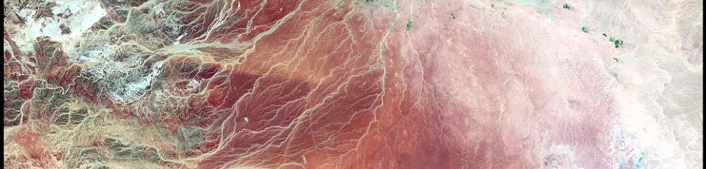
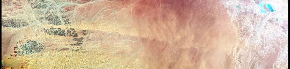
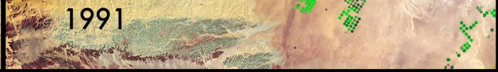
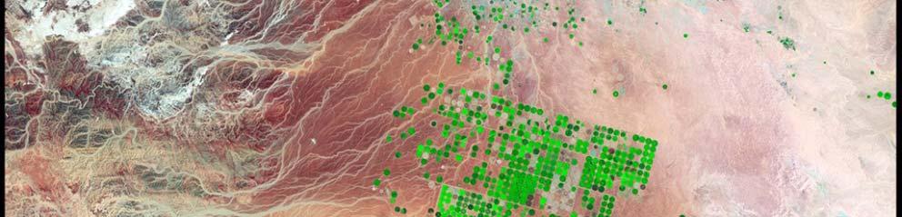
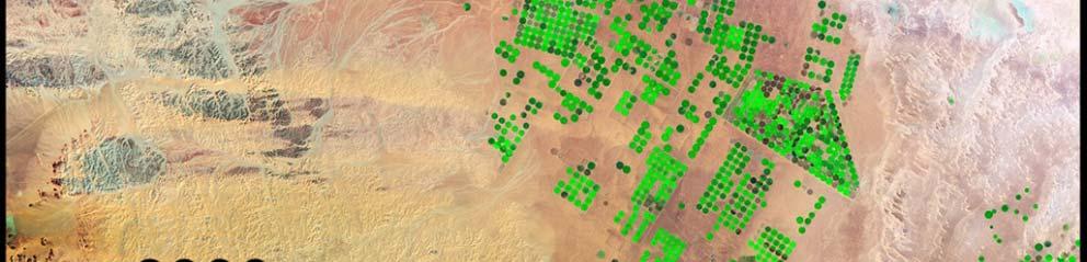
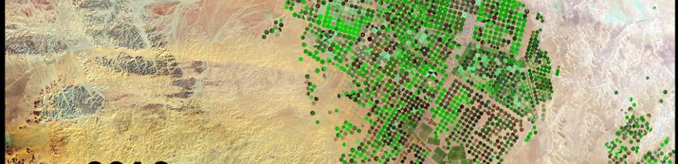
13 Growth of Irrigation in Saudi Arabia Rate of change of water storage (cm/yr) Landsat images prepared by Aries Keck, NASA/GSFC


14 Groundwater Depletion in Saudi Arabia Water Storag ge Anomaly (cm m) Total Terrestrial Water Soil Water Groundwater Groundwater Trend -10 Mar-03 Mar-04 Mar-05 Mar-06 Mar-07 Mar-08 Mar-09 Mar-10 Mar-11 Mar-12 Date Preliminary estimate of groundwater depletion rate: 2.6 km 3 /yr. This includes the impact of a persistent drought in the region, as indicated by the soil water time series.
 10 8 6 4 2 0-2")


15 Groundwater Depletion in the North China Plain Water Storage Anom maly (cm) Total Terrestrial Water Soil Water Groundwater Groundwater Trend -10 Mar-03 Mar-04 Mar-05 Mar-06 Mar-07 Mar-08 Mar-09 Mar-10 Mar-1 1 Mar-12 Date Preliminary estimate of groundwater depletion rate: 4.9 km 3 /yr. Estimate likely would increase if properly scaled to account for leakage.


16 Emerging Trends in Global Freshwater Storage Trends in terrestrial water storage (cm/yr), including groundwater, soil l k d i b d b GRACE d i water, lakes, snow, and ice, as observed by GRACE during Alaska s glaciers have been melting at 84 km 3 /yr Greenland s ice sheet has been thinning at a rate of 142 km 3 /yr Russian droughts in 2010 and 2012 Groundwater is being depleted across northern India at rate of about 54 km 3 /yr due to pumping for irrigation Drought gave way to flooding in the Missouri River basin in 2011 Recent droughts in the southern U.S. Recovery from drought in the Amazon 2010 Chile earthquake and drought in southern Argentina Patagonian glacier melt The western Antarctic ice sheet has been thinning at a rate of 65 km 3 /yr Overexploitation of freshwater resources in the North China Plain Return to normal after wet years in early 2000s Drought recovery and flooding Depletion of water resources in Middle East, exacerbated by drought Return to normal in the Okavango Delta after drought ended in 2007 GRACE observes changes in water storage caused by natural variability, climate change, and human activities such as groundwater pumping
17 Land Surface Models (LSMs) LSMs solve for the interaction of energy, momentum, and mass between the surface and the atmosphere in each model element (grid cell) at each discrete time-step (~15 min) GRID SUBGRID HETEROGENEITY NEEDLELEAF TREES: 25% SHRUBS: 10% BARE SOIL: 15% GRASSLAND: 50% SURFACE VEGETATION ATMOSPHERE TRANSFER SCHEME Input - Output = Storage Change P + G in (Q + ET + G out) ) = ΔS R n -G = L e + H System of physical equations: Surface energy conservation equation Surface water conservation equation Soil water flow: Richards equation Evaporation: Penman-Monteith equation etc.
 surface pressure Summary of Output Fields: soil moisture in each")
18 Input Parameters: vegetation class vegetation greenness/lai soil type elevation LSM Input and Output Fields Required Forcing Fields: total precipitation convective precipitation downward shortwave radiation downward longwave radiation near surface air temperature near surface specific humidity near surface wind speed (U & V) surface pressure Summary of Output Fields: soil moisture in each layer snow water equivalent soil temperature in each layer surface and subsurface runoff evaporation transpiration latent, sensible, and ground heat fluxes snowmelt snowfall and rainfall net shortwave and longwave radiation

 for June 2007.")


19 GRACE Data Assimilation for Drought Monitoring GRACE terrestrial water storage anomalies (cm equivalent height of water) for June New process integrates data from GRACE and other satellites to produce timely information on wetness conditions at all levels in the soil column, including groundwater. For current maps and more info, see unl U.S. Drought Monitor product for 26 July Surface Soil Moisture Root Zone Soil Moisture Groundwater Drought indicators from GRACE data assimilation (wetness percentiles relative to the period 1948-present) for 26 June 2007.
20 Indicators of Drought Based on GRACE Data Assimilation
21 Summary and Future Prospects Due to the incompleteness of ground-based d observations, space-based observation of global freshwater resources is critical. NASA s GRACE satellite mission is unique in its ability to monitor all forms of water at all depths, including groundwater. Emerging trends in terrestrial water storage observed by GRACE during can be categorized as natural variations, climate change impacts, or direct consequences of human activities, particularly irrigation. The value of GRACE and other satellite data for applications such as drought monitoring can be enhanced by combining them within a land surface model. The GRACE Follow-On mission is scheduled to launch in August 2017.
22 Data, Visualization, Educational Materials t / / d ti / - GRACE educational materials -GRACE data, images, and animations - Soil Moisture Active Passive Mission - Tropical Rainfall Measurement Mission - Global Precipitation Measurement Mission - Satellite based monitoring of lake and reservoir levels - Giovanni Earth science data visualization tool National Drought Mitigation Center - NASA/GSFC Water Resources Applications Projects water html - Feature on Indian groundwater depletion detected by GRACE
Chief, Hydrological Sciences Laboratory NASA Goddard Space Flight Center
 Detection of Extreme Events with GRACE and Data Assimilation, Ph.D. Chief, Hydrological Sciences Laboratory NASA Goddard Space Flight Center Gravity Recovery and Climate Experiment (GRACE) Soil Moisture
Monitoring Terrestrial Hydrology with GRACE Satellites
 Monitoring Terrestrial Hydrology with GRACE Satellites Alys Thomas University of California, Irvine USA International Workshop on Small Satellite and Sensor Technology for Disaster Management April 2,
21 st Century Water Security and Implications for Animal Agriculture
 21 st Century Water Security and Implications for Animal Agriculture Cumulative freshwater losses in California (left), the Middle East (center) and NW India (right) from GRACE, 2002-2014 Famiglietti,
Global Evaluation of Apparent Trends in Terrestrial Water Storage Observed by GRACE
 Global Evaluation of Apparent Trends in Terrestrial Water Storage Observed by GRACE Matt Rodell*, Jay Famiglietti, David Wiese, J.T. Reager, Hiroko Beaudoinga, Felix Landerer, and Min-Hui Lo *Hydrological
supplies over half of the drinking water in the United States supplies over 60% of the water used for irrigation in the United States
 Groundwater accounts for 96% of unfrozen freshwater globally...is the major source of water for over 2 billion people globally supplies roughly 45% of water for irrigation globally supplies over half of
Water Resilience to Climate Change and Human Development
 Institute for Risk and Disaster Reduction Water Resilience to Climate Change and Human Development Mohammad Shamsudduha ( Shams ) PhD in Hydrogeology (UCL) Research Fellow (UCL IRDR) m.shamsudduha@ucl.ac.uk
NASA Assets that Support of the Water- Energy-Food Nexus
 NASA Assets that Support of the Water- Energy-Food Nexus Richard Lawford 4 th Regional WEF Nexus Workshop Hilton, Pietermaritzburg, South Africa November 21, 2016 Observation Strategy for the Water Cycle
An Overview of JULES. Christina Bakopoulou
 An Overview of JULES Christina Bakopoulou JULES, MOSES AND TRIFFID JULES (Joint UK Land Environment Simulator) is a new land surface model Joint initiative: NERC through the CEH, CLASSIC, QUEST and the
Effects of Land Use On Climate and Water Resources: Application of a Land Surface Model for Land Use Management
 Effects of Land Use On Climate and Water Resources: Application of a Land Surface Model for Land Use Management Gordon Bonan, PI National Center for Atmospheric Research Boulder, Colorado Personnel Supported:
NASA International Water Activities Towards Water Security
 National Aeronautics & NASA International Water Activities Towards Water Security David Toll Hydrological Sciences NASA/GSFC NASA Water Resources Support Bradley Doorn NASA Manager Nancy Searby NASA Capacity
The Water Cycle and Water Insecurity
 The Water Cycle and Water Insecurity EQ1: What are the processes operating within the hydrological cycle from global to local scale? 6 & 8 markers = AO1. 12 & 20 markers = AO1 and AO2 larger weighting
Measuring and Monitoring a Lack of Resilience, and Informing Resilience Operations
 Measuring and Monitoring a Lack of Resilience, and Informing Resilience Operations Using existing, often emergency-oriented tools and data, in a slightly different manner, to measure long-standing, underlying,
Mapping the Blue Marble: NASA Research to Improve Monitoring and Forecasting of Water Resources
 Mapping the Blue Marble: NASA Research to Improve Monitoring and Forecasting of Water Resources John Bolten Associate Program Manager NASA Applied Sciences Program Water Resources john.bolten@nasa.gov
Drought monitoring and prediction using NOAH land surface model and GRACE satellite observation
 Drought monitoring and prediction using NOAH land surface model and GRACE satellite observation Xiaodong Zhang, Jiexia Wu Department of Earth System Science and Policy University of North Dakota Drought:
Land Modeling II - Biogeochemistry: Ecosystem Modeling and Land Use Dr. Peter Lawrence
 Land Modeling II - Biogeochemistry: Ecosystem Modeling and Land Use Dr. Peter Lawrence Project Scientist Terrestrial Science Section Climate and Global Dynamics Division (With thanks to TSS and IAM groups
Extending the societal and economic benefits of Earth science research, information, and technology
 NASA WATER SCIENCE & APPLICATIONS NASA S APPLIED SCIENCES PROGRAM Steven Ambrose 1, Jared Entin 2, David Toll 3 and Ted Engman 4 1- Applied Sciences Program, NASA/HQ 2-TerrestrialHydrology Program & NASA
Proposed Project. Integrated Water Resources Management Using Remote Sensing Data in Upper Indus Basin
 Proposed Project Integrated Water Resources Management Using Remote Sensing Data in Upper Indus Basin Background Snowmelt contributes more than 6% of water resources of Upper Indus Basin Most of the moisture
NASA s Contribution to Water Research, Applications, and Capacity Building in Africa
 NASA s Contribution to Water Research, Applications, and Capacity Building in Africa Nancy D. Searby 1, David Toll 2, Rick Lawford 3, 1 NASA HQ Earth Sciences Division Applied Sciences Program 2 NASA GSFC
Hydrological Feedbacks in Tropical African Wetlands
 Hydrological Feedbacks in Tropical African Wetlands Simon Dadson University of Oxford (simon.dadson@ouce.ox.ac.uk) Key challenges Linking across scales: can we predict the hydrological response to climate
HEARING ON PERSPECTIVES ON CALIFORNIA WATER SUPPLY: CHALLENGES AND OPPORTUNITIES
 WRITTEN TESTIMONY OF DR. JAMES S. FAMIGLIETTI DIRECTOR, UC CENTER FOR HYDROLOGIC MODELING PROFESSOR OF EARTH SYSTEM SCIENCE PROFESSOR OF CIVIL AND ENVIRONMENTAL ENGINEERING UNIVERSITY OF CALIFORNIA, IRVINE
INTEGRATING ENHANCED GRACE TERRESTRIAL WATER STORAGE DATA INTO THE U.S. AND NORTH AMERICAN DROUGHT MONITORS INTRODUCTION
 INTEGRATING ENHANCED GRACE TERRESTRIAL WATER STORAGE DATA INTO THE U.S. AND NORTH AMERICAN DROUGHT MONITORS Rasmus Houborg, Physical Scientist NASA Goddard Space Flight Center (GSFC), Greenbelt, MD 20771
The Hydrosphere: Lecture 7: Evapotranspiration. Paul R. Houser,27 March 2012, Page 1
 The Hydrosphere: Lecture 7: Evapotranspiration Paul R. Houser,27 March 2012, Page 1 Evapotranspiration evapotranspiration summarizes all processes that return liquid water back into water vapor evaporation
International LCLUC Regional Science Meeting in Central Asia
 International LCLUC Regional Science Meeting in Central Asia September 23, 2013 Samarkand, Uzbekistan NASA Astronaut picture from ISS Tashkent, Uzbekistan November 11-13, 2013 Shahid Habib, D.Sc., PE Chief,
Sustainability and Climate Change: What Everyone Should Know
 University of Colorado, Boulder CU Scholar Science Boot Camp for Librarians West University Libraries Spring 5-1-2013 Sustainability and Climate Change: What Everyone Should Know Jim White University of
Southern Sierra Headwaters Tour
 Southern Sierra Headwaters Tour Introduction The headwaters of the Sierra Nevada support the needs of California s diverse downstream communities, economies, and environments. On this tour and in our research,
CHAPTER ONE : INTRODUCTION
 CHAPTER ONE : INTRODUCTION WHAT IS THE HYDROLOGY? The Hydrology means the science of water. It is the science that deals with the occurrence, circulation and distribution of water of the earth and earth
Water Science and the Environment HWRS 201
 Water Science and the Environment HWRS 201 Dr. Mr. Ghasemian 2015 Office hours and contact information Office hours MWF - or by appointment Starting Harshbarger 3 Contact 621- r @.arizona.edu D2L site
Modelling the spatial variability of the snowcover and the surface energy fluxes at TVC. S. Endrizzi, P. Marsh, and S. Pohl
 Modelling the spatial variability of the snowcover and the surface energy fluxes at TVC S. Endrizzi, P. Marsh, and S. Pohl Purpose of Study Study the effects of topography and land cover on snow cover
Adaption to climate change: New technologies for water management and impact assessment
 Adaption to climate change: New technologies for water management and impact assessment Wim Bastiaanssen Director WaterWatch (NL) Professor at Delft University of Technology (NL) Some selected problems
Global Groundwater Withdrawal
 Global Groundwater Withdrawal Large withdrawals in North India, Western US, Middle East, Spain Global total ~630 km 3 More than 90% is used for irrigation Reported: Wada et al., 010 (IGRAC) Results agree
Climate change impacts on water resources in the Upper Po basin
 limate change impacts on water resources in the Upper Po basin Giovanni Ravazzani, Marco Mancini, hiara orbari, Alessandro eppi, Laura Boscarello, Giulia Ercolani Department of ivil and Environmental Engineering
Evaporation from a temperate closed-basin lake and its impact on present, past, and future water level
 Evaporation from a temperate closed-basin lake and its impact on present, past, and future water level Ke Xiao, Tim Griffis, John Baker, Paul Bolstad, Matt Erickson, Xuhui Lee, Jeff Wood, Cheng Hu Presenter:
Storage Change = P - R - E = SWE + SMS + GWS
 Integrating surface and space-based gravity observations in hydrologic studies (Extended Abstract) Clark R. Wilson, Jianli Chen, John A Sharp, Bridget Scanlon, Honqiu Wu, Liang Yang The University of Texas
Lecture 15: Flood Mitigation and Forecast Modeling
 Lecture 15: Flood Mitigation and Forecast Modeling Key Questions 1. What is a 100-year flood inundation map? 2. What is a levee and a setback levee? 3. How are land acquisition, insurance, emergency response
M.L. Kavvas, Z. Q. Chen, M. Anderson, L. Liang, N. Ohara Hydrologic Research Laboratory, Civil and Environmental Engineering, UC Davis
 Assessment of the Restoration Activities on Water Balance and Water Quality at Last Chance Creek Watershed Using Watershed Environmental Hydrology (WEHY) Model M.L. Kavvas, Z. Q. Chen, M. Anderson, L.
Lecture 1: Hydrologic cycle
 1-1 GEOG415 Lecture 1: Hydrologic cycle Hydrologic cycle is ultimately driven by solar radiation, which evaporates water from the ocean and lift it up in the atmosphere. Dunne & Leopold, 1978, Fig. 1-1
DEPARTMENT OF GEOGRAPHY POST GRADUATE GOVT. COLLEGE FOR GIRLS.SECTOR-11 CHANDIGARH CLASS-B.A.II PAPER-A RESOURCES AND ENVIRONMENT: WORLD PATTERNS
 DEPARTMENT OF GEOGRAPHY POST GRADUATE GOVT. COLLEGE FOR GIRLS.SECTOR-11 CHANDIGARH CLASS-B.A.II PAPER-A RESOURCES AND ENVIRONMENT: WORLD PATTERNS Hydrological cycle The sun, which drives the water cycle,
American Geophysical Union Meeting H34D.
 Using NASA Products of the Water Cycle for Improved Water Resources Management Brad Doorn (NASA/HQ), David Toll (NASA/GSFC), Rick Lawford (UMBC), and E. Engman (SAIC) 15 December 2010 American Geophysical
WATER AND THE HYDROLOGIC CYCLE
 WATER AND THE HYDROLOGIC CYCLE Summary Water is essential for the support of life and can be considered as a fundamental environmental good. Water is needed to support human habitation, grow crops and
Projection of the Impact of Climate Change on the Surface Energy and Water Balance in the Seyhan River Basin Turkey
 Projection of the Impact of Climate Change on the Surface Energy and Water Balance in the Seyhan River Basin Turkey Kenji TANAKA 1, Yoichi FUJIHARA 2 and Toshiharu KOJIRI 3 1 WRRC, DPRI, Kyoto University,
Orange County Sustainability Collabora2ve Panel 1 Imported Water Resources Groundwater Deple5on Impacts of Climate Change
 Orange County Sustainability Collabora2ve Panel 1 Imported Water Resources Groundwater Deple5on Impacts of Climate Change Stephanie Castle 11/10/2014 What is GRACE? Gravity Recovery and Climate Experiment:
ESTIMATION OF IRRIGATION WATER SUPPLY FROM NONLOCAL WATER SOURCES IN GLOBAL HYDROLOGICAL MODEL
 ESTIMATION OF IRRIGATION WATER SUPPLY FROM NONLOCAL WATER SOURCES IN GLOBAL HYDROLOGICAL MODEL S. Kitamura 1, S. Yoshikawa 2, and S. Kanae 3 11 Tokyo Institute of Technology, kitamura.s.ag@m.titech.ac.jp:
LARGE SCALE SOIL MOISTURE MODELLING
 Soil Moisture Workshop LARGE SCALE SOIL MOISTURE MODELLING Giuseppe Formetta, Vicky Bell, and Eleanor Blyth giufor@nerc.ac.uk Centre for Ecology and Hydrology, Wallingford, UK Wednesday 25 th January 2017
Hydrologic Modeling with the Distributed-Hydrology- Soils- Vegetation Model (DHSVM)
") Hydrologic Modeling with the Distributed-Hydrology- Soils- Vegetation Model (DHSVM) DHSVM was developed by researchers at the University of Washington and the Pacific Northwest National Lab 200 Simulated
Hydrologic Modeling with the Distributed-Hydrology- Soils- Vegetation Model (DHSVM) DHSVM was developed by researchers at the University of Washington and the Pacific Northwest National Lab 200 Simulated
Assessment of Groundwater Resources in the South Platte Basin, CO
 Assessment of Groundwater Resources in the South Platte Basin, CO Christopher J. Ruybal, Terri S. Hogue, John E. McCray Civil and Environmental Engineering, Colorado School of Mines, 1500 Illinois Street,
Earth s Water Reservoirs
 Earth s Water Reservoirs Introduction What do you think of when you hear the word reservoir? Living in Utah, most of us will think of a man made lake that stores needed water. Many of us have been swimming,
Representing the Integrated Water Cycle in Community Earth System Model
 Representing the Integrated Water Cycle in Community Earth System Model Hong-Yi Li, L. Ruby Leung, Maoyi Huang, Nathalie Voisin, Teklu Tesfa, Mohamad Hejazi, and Lu Liu Pacific Northwest National Laboratory
M.L. Kavvas, Z. Q. Chen, M. Anderson, L. Liang, N. Ohara Hydrologic Research Laboratory, Civil and Environmental Engineering, UC Davis
 Assessment of the Restoration Activities on Water Balance and Water Quality at Last Chance Creek Watershed Using Watershed Environmental Hydrology (WEHY) Model M.L. Kavvas, Z. Q. Chen, M. Anderson, L.
Texas Soil Observation Network: TxSON Linking Soil Moisture to Water Resources in the Texas Hill Country. Todd Caldwell
 Texas Soil Observation Network: TxSON Linking Soil Moisture to Water Resources in the Texas Hill Country Todd Caldwell Michael Young and Bridget Scanlon CAHMDA/DAFOH 10 September 2014, Austin, TX Soil
Water Science and the Environment
 Water Science and the Environment HWRS 201 Dr. Zreda Mr. Ghasemian Fall 2015 Surface Evaporation: Overview Evaporation is a process that transfers energy from the Earth s surface to the atmosphere. Some
Planning Beyond the Supply/Demand Gap: Water Supply Vulnerabilities in New Mexico Presented by NM Universities Working Group on Drought
 Planning Beyond the Supply/Demand Gap: Water Supply Vulnerabilities in New Mexico Presented by NM Universities Working Group on Drought 1 Janie Chermak, David Gutzler, Peggy Johnson, J. Phillip King, Lee
The Noah-MP Land Surface Model. Michael Barlage Research Applications Laboratory National Center for Atmospheric Research
 The Noah-MP Land Surface Model Michael Barlage Research Applications Laboratory National Center for Atmospheric Research 1 2 Conceptual Land Surface Processes Precipitation Transpiration Canopy Water Evaporation
Agronomy 406 World Climates
 Agronomy 406 World Climates February 13, 2018 Hydrologic cycle. Team 4 Climate News presentation this Thursday. Review: METED module, Understanding the Hydrologic Cycle Active review session for the midterm
The Noah-MP Land Surface Model
 The Noah-MP Land Surface Model Michael Barlage Research Applications Laboratory National Center for Atmospheric Research 1 Land Surface Models: Summary Land surface models have long been used as stand-alone
Remote Sensing of Water Resources
 Remote Sensing of Water Resources National Disaster Management Institute Yoomi Hur Climate Change Hydrologic Cycle Hydrologic Indices Soil Moisture Evaportranspiration Drought Conclusions 3 The water cycle
A Roadmap for Future Satellite Gravity Missions
 A Roadmap for Future Satellite Gravity Missions - The Graz Workshop (- The Roadmap) - Why time-variable gravity? - The Declaration - Hope and Long-Term Perspective Hans-Peter Plag1, Roland Pail2, Michael
Mountain hydrology of the semi-arid western U.S.: Research needs, opportunities & challenges
 Mountain hydrology of the semi-arid western U.S.: Research needs, opportunities & challenges Roger Bales 1, Jeff Dozier 2, Noah Molotch 3, Tom Painter 3, Bob Rice 1 1 UC Merced. 2 UC Santa Barbara, 3 U
USDA-NRCS, Portland, Oregon
 Hydrologic Simulation Modeling for Streamflow Forecasting and Evaluation of Land and Water Management Practices in the Sprague River, Upper Klamath Basin, Oregon, USA David Garen John Risley Jolyne Lea
1 THE USGS MODULAR MODELING SYSTEM MODEL OF THE UPPER COSUMNES RIVER
 1 THE USGS MODULAR MODELING SYSTEM MODEL OF THE UPPER COSUMNES RIVER 1.1 Introduction The Hydrologic Model of the Upper Cosumnes River Basin (HMCRB) under the USGS Modular Modeling System (MMS) uses a
Country proposal - SRI LANKA
 Country proposal - SRI LANKA P. M. Jayatilaka Banda Department of Meteorology, Nihal Rupasinghe Central Engineering Consultancy Bureau and S. B. Weerakoon University of Peradeniya, Sri Lanka Asia Water
Enhancement of water storage estimates using GRACE data assimilation with particle filter framework
 22nd International Congress on Modelling and Simulation, Hobart, Tasmania, Australia, 3 to 8 December 2017 mssanz.org.au/modsim2017 Enhancement of water storage estimates using GRACE data assimilation
Ensuring Water in a Changing World
 Ensuring Water in a Changing World Climate Change & The Global Water Cycle: Recent Regional Experiences Soroosh Sorooshian Center for Hydrometeorology and Remote Sensing University of California Irvine
Title: WP6 (Hydrological Service)
") Title: WP6 (Hydrological Service) Ben Gouweleeuw (GFZ) EGSIEM General Assembly U Bern Jan 18-19.2017 WP6: Hydrological Service Other activities & outlook of last meeting Revise and re-submit paper on evaluation
Title: WP6 (Hydrological Service) Ben Gouweleeuw (GFZ) EGSIEM General Assembly U Bern Jan 18-19.2017 WP6: Hydrological Service Other activities & outlook of last meeting Revise and re-submit paper on evaluation
Uncertainty in hydrologic impacts of climate change: A California case study
 Uncertainty in hydrologic impacts of climate change: A California case study Ed Maurer Civil Engineering Dept. Santa Clara University Photos from USGS Motivating Questions What are potential impacts of
Seasonal Variation of Total Terrestrial Water Storage in Major River Basins
 http://hydro.iis.u-tokyo.ac.jp/ 1 Seasonal Variation of Total Terrestrial Water Storage in Major River Basins T Oki, P. Yeh, K Yoshimura, H Kim, Y Shen, N D Thanh, S Seto, and S Kanae Institute of Industrial
Drought Indices in North America. Richard R. Heim Jr.
 Drought Indices in North America Richard R. Heim Jr. NOAA/NESDIS/ Asheville, North Carolina, USA Inter-Regional Workshop on Indices and Early Warning Systems for Drought WMO/NDMC/NOAA/UNCCD/USDA Lincoln,
ABCC Program: Status and Progress
 ABCC Program: Status and Progress Huadong Guo ABCC Program Team September 23, 2010 Ottawa, Canada Outline Global Change Challenge Why ABCC? Research Framework Current Progress Future Perspective 1. Global
The Impact of Wetland Drainage on the Hydrology of a Northern Prairie Watershed
 John Pomeroy, Xing Fang, Stacey Dumanski, Kevin Shook, Cherie Westbrook, Xulin Guo, Tom Brown, Adam Minke, Centre for Hydrology, University of Saskatchewan, Saskatoon, Canada The Impact of Wetland Drainage
Systems at risk: Climate change and water for agriculture
 Systems at risk: Climate change and water for agriculture Jean-Marc Faurès Land and Water Division FAO-WB Workshop on Climate Change Adaptation in Agriculture in East Asia and the Pacific FAO, Rome, May
4 EVAPORATION AND TRANSPIRATION
 4 EVAPORATION AND TRANSPIRATION Evaporation, the transfer of water from the basin surface to the atmosphere, is the main term facing rainfall input in the water balance equation. It is therefore an important
Zhe Zhang 1, Yanping Li 1, Michael Barlage 2, Fei Chen 2. University of Saskatchewan 2. National Center for Atmospheric Research
 Zhe Zhang 1, Yanping Li 1, Michael Barlage 2, Fei Chen 2 1 University of Saskatchewan 2 National Center for Atmospheric Research Wetlands in Prairie Pothole Region Large area in the center of North America
Prairie Hydrology. If weather variability increases, this could degrade the viability of many aspects of ecosystems, human activities and economy
 Prairie Hydrology John Pomeroy, Xing Fang, Robert Armstrong, Tom Brown, Kevin Shook Centre for Hydrology, University of Saskatchewan, Saskatoon, Canada Climate Change for the Prairies? Highly variable
Continental-scale water resources modeling
 Continental-scale water resources modeling Ingjerd Haddeland and Thomas Skaugen (University of Oslo/Norwegian Water Resources and Energy Directorate) Dennis P. Lettenmaier (University of Washington) Outline
Estimating Groundwater Recharge within Wisconsin s Central Sands
 Estimating Groundwater Recharge within Wisconsin s Central Sands Adam Freihoefer and Robert Smail Wisconsin Department of Natural Resources [study objective] Identify a defensible approach to quantify
Ecosystems on land are grouped into biomes primarily based on the plant communities within them.
 Section 2: Ecosystems on land are grouped into biomes primarily based on the plant communities within them. K What I Know W What I Want to Find Out L What I Learned Essential Questions How is latitude
Physically-based Distributed Hydrologic Modeling
 Physically-based Distributed Hydrologic Modeling Goal of Phys.-based Distrib. Hydrologic Modeling To date we have learned about: Key forcings at land surface (precipitation/net radiation) Physical processes
BAEN 673 / February 18, 2016 Hydrologic Processes
 BAEN 673 / February 18, 2016 Hydrologic Processes Assignment: HW#7 Next class lecture in AEPM 104 Today s topics SWAT exercise #2 The SWAT model review paper Hydrologic processes The Hydrologic Processes
Water balance in soil
 Technische Universität München Water balance Water balance in soil Arno Rein Infiltration = + precipitation P evapotranspiration ET surface runoff Summer course Modeling of Plant Uptake, DTU Wednesday,
Human Impact on the Environment: Part I
 Human Impact on the Environment: Part I The late Alan Gregg pointed out that human population growth within the ecosystem was closely analogous to the growth of malignant tumor cells, that man was acting
A Case Study on Integrated Urban Water Modelling using Aquacycle NTUA, 2007
 A Case Study on Integrated Urban Water Modelling using Aquacycle NTUA, 2007 Contents Motivation Input Data Requirements Case Study - Greater Athens Area Model calibration and validation Formulation and
Modeling Long Term Soil Moisture and Evapotranspiration Dynamics in a Temperate Grassland in Inner Mongolia, China
 Modeling Long Term Soil Moisture and Evapotranspiration Dynamics in a Temperate Grassland in Inner Mongolia, China Lu Hao 1, Ge Sun 2, Yongqiang Liu 2, Guangsheng Zhou 3 and Lizhe Yang 1 1. IceMe, Nanjing
Assimilation of satellite observations into hydrological forecasting An Australian perspective
 Assimilation of satellite observations into hydrological forecasting An Australian perspective Albert van Dijk Australian National University, CSIRO Land and Water, Canberra Thanks to: Luigi Renzullo,
LAND AND WATER - EARTH OBSERVATION INFORMATICS FSP
 Earth Observation for Water Resources Management Arnold Dekker,Juan P Guerschman, Randall Donohue, Tom Van Niel, Luigi Renzullo,, Tim Malthus, Tim McVicar and Albert Van Dijk LAND AND WATER - EARTH OBSERVATION
Groundwater Depletion Is Detected From Space By FELICITY BARRINGER
 Reprints This copy is for your personal, noncommercial use only. You can order presentation-ready copies for distribution to your colleagues, clients or customers here or use the "Reprints" tool that appears
Terrestrial Water Cycle and Climate Change: Linkages and Feedbacks
 Terrestrial Water Cycle and Climate Change: Linkages and Feedbacks The Atmosphere External Forcing Internal Adjustment The Ice Result The Continents The Oceans Climate System Terrestrial Water Cycle and
3/1/18 USING RADAR FOR WETLAND MAPPING IMPORTANCE OF SOIL MOISTURE TRADITIONAL METHODS TO MEASURE SOIL MOISTURE. Feel method Electrical resistance
 3/1/18 USING RADAR FOR WETLAND MAPPING SOIL MOISTURE AND WETLAND CLASSIFICATION Slides modified from a presentation by Charlotte Gabrielsen for this class. Southeast Arizona: Winter wet period From C.
CONTROL OF WETLAND HYDROLOGY BY BIOTIC PROCESSES
 HANDOUT # 2 (For 10/6 and 10/8 2004) ESP 155 Wetland Ecology, Fall 2004 Hydrology WETLAND HYDROLOGY Basic terms & concepts - most important determinant for establishing and maintenance of specific types
Inputs. Outputs. Component/store. Section of a system where material or energy is held. Something that enters the system (material or energy)
") .. Inputs Something that enters the system (material or energy) Outputs Something that leaves the system (material or energy) Component/store Section of a system where material or energy is held Transfer/flow
.. Inputs Something that enters the system (material or energy) Outputs Something that leaves the system (material or energy) Component/store Section of a system where material or energy is held Transfer/flow
Graham Jewitt School of Bioresources Engineering and Environmental Hydrology University of KwaZulu-Natal
 Graham Jewitt School of Bioresources Engineering and Environmental Hydrology University of KwaZulu-Natal A massive land- grabbing scramble in Africa as foreign companies - some with foreign aid money support
The Hydrologic Cycle. October 7, 2010
 The Hydrologic Cycle October 7, 2010 Why do we care about the hydrologic cycle? The amount of water that flows through the hydrologic cycle each year is equal to about a 1 m depth of water averaged over
The Western States Water Mission CUAHSI Hydroinformatics meeting 16 July 2015
 Jet Propulsion Laboratory, California Institute of Technology The Western States Water Mission CUAHSI Hydroinformatics meeting 16 July 2015 Water Cycle and Freshwater Availability Next Challenge : Adding
Characterising the Surface Hydrology of Prairie Droughts
 QdroD QdfoD Qdro Qdfo SunMax C:\ Program Files\ CRHM\ Qsi global CalcHr t rh ea u p ppt Qso Qn Qln SunAct form_data calcsun Qsi hru_t hru_rh hru_ea hru_u hru_p hru_rain hru_snow hru_sunact hru_tmax hru_tmin
The Hydrological Cycle. Hydrological Cycle. Definition of Terms. Soils and Water, Spring Lecture 7, The Hydrological Cycle 1
 The Hydrological Cycle Water vapor helps warm up the earth Evaporation+Transpiration Chemical Spill Runoff To Oceans Water potential, atmosphere Hydrological Cycle Transpiration, T Atmospheric pool Interception
Projection of the Impact of Climate Change on the Surface Energy and Water Balance in the Seyhan River Basin Turkey
 Projection of the Impact of Climate Change on the Surface Energy and Water Balance in the Seyhan River Basin Turkey Kenji TANAKA 1, Yoichi FUJIHARA 2 and Toshiharu KOJIRI 3 1 WRRC, DPRI, Kyoto University,
Groundwater in the Mekong Region Transboundary Aquifers
 Groundwater in the Mekong Region Transboundary Aquifers Felix Seebacher, PhD Information and Knowledge Management Programme Mekong River Commission Secretariat International Conference on Cooperation for
Global Water Cycle. Evaporation : evaporation of seawater leaves the salts behind, thereby salinity
 Hydrologic Cycle o Hydrologic Cycle : a model for where water is stored on Earth & how it moves from one place to another The hydrologic cycle is powered by the sun Understanding how water travels between
SNAMP water research. Topics covered
 SNAMP water research SNAMP water team UC Merced Topics covered Objectives, goals & overview What & why the water component of SNAMP Pre-treatment Observations Water Quality Water Quantity Modeling & Scenarios:
PART IV WATER QUANTITY MONITORING, TECHNOLOGICAL ADVANCES AND CONCLUSIONS
 PART IV WATER QUANTITY MONITORING, TECHNOLOGICAL ADVANCES AND CONCLUSIONS 17.1 INTRODUCTION CHAPTER 17 Water Quantity Monitoring The Okanagan Study has revealed the need for an improved monitoring system
EVALUATION OF HYDROLOGIC AND WATER RESOURCES RESPONSE TO METEOROLOGICAL DROUGHT IN THESSALY, GREECE
 EVALUATION OF HYDROLOGIC AND WATER RESOURCES RESPONSE TO METEOROLOGICAL DROUGHT IN THESSALY, GREECE A. LOUKAS*, AND L. VASILIADES Laboratory of Hydrology and Water Systems Analysis,, Volos, Greece *E-mail:
Global and Planetary Change
 Global and Planetary Change 106 (2013) 20 30 Contents lists available at SciVerse ScienceDirect Global and Planetary Change journal homepage: www.elsevier.com/locate/gloplacha Large-scale variations of