A Summary Guide to the. Rifle River WATERSHED MANAGEMENT PLAN. Know Your Watershed Protect Its Resources
|
|
|
- Kerrie Phillips
- 6 years ago
- Views:
Transcription

1 A Summary Guide to the Rifle River WATERSHED MANAGEMENT PLAN Know Your Watershed Protect Its Resources
2 Table of Contents The Watershed... 3 The Management Plan... 4 Designated and Desired Uses... 5 Sources and Causes of Pollution... 6 Prioritizing Conservation Activities... 7 The Action Plan... 8 Accomplishments Best Management Practices Partnerships Get Involved... 15


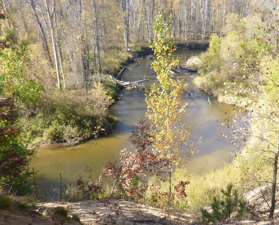
3 Rifle River Watershed Quick Facts Land Area (mi 2 ) Mainstem Rifle River (mi) Total stream miles Communities (2010 population) West Branch...2,139 Rose City Omer Land Cover/Use: Forested... 48% Agriculture... 21% Wetland... 11% Developed... 3% Other... 17% 10 Miles What is a watershed? The Rifle River the highest quality tributary to Saginaw Bay flows undammed for 60 miles through the forests and farmlands of Ogemaw and Arenac counties. The Rifle River Watershed is an excellent setting for year-round outdoor recreation and is home to a rich community of fish and wildlife. The 4,449-acre Rifle River State Recreation Area offers a variety of outdoor activities and most streams in the watershed hold trout. Many of the watershed's streams are designated by the Michigan DNR as Natural Rivers, including the entire main stem of the Rifle River upstream from Omer. The healthy natural resources of the Rifle River Watershed provide clean water, support food production and attract tourists from all over the region providing strength and resiliency to local economies and serving as a source of pride for residents. This Watershed Management Plan will help ensure the continued protection of these important assets. A watershed is an area of land that contains a common set of streams, rivers and lakes that all drain into a larger waterbody. Every place is a part of a watershed. Because water and land features are closely interconnected, any effort to protect water quality must address both the water features and the surrounding land areas. Watershed boundaries are defined by physical features of the landscape and can be subdivided. For example, the Prior Creek Watershed lies within the Rifle River Watershed, which is itself a part of the Lake Huron Watershed. 3

4 Rifle River Watershed Management Plan This summary guide highlights the major goals and objectives, plan of action and roles and responsibilities that are detailed in the Rifle River Watershed Management Plan. The full Rifle River Watershed Management Plan includes the following: A review of the geophysical and socioeconomic characteristics of the watershed A detailed summary of all historical monitoring sites and an overview of watershed condition The methodology and results of recent inventories of road/stream crossings, streambank erosion sites, agricultural land stewardship practices, invasive plant species, urban stormwater and other natural resource concerns throughout the watershed A description of how inventory data is being used to prioritize sites for conservation projects A prioritized summary table of all known and suspected sources and causes of pollution Strategies for addressing each source and cause of pollution and other resource concerns A detailed 10-year action plan that identifies measures necessary for protecting Desired Uses and Designated Uses within the Rifle River Watershed An information and education strategy that outlines the importance of increasing public participation in watershed management and restoration activities A monitoring strategy for evaluating both the technical effectiveness of restoration projects and the rate of progress in implementing action steps outlined in the management plan Useful contact information for organizations actively working in the Rifle River Watershed Mission Statement To provide leadership for a holistic approach to the conservation, restoration and enhancement of the unique land and water resources of the watershed to provide for greater health and resilience for those resources essential to the strength of the local community. Technical Committee The Rifle River Watershed Technical Committee (RRWTC) was formed in 2012 to provide technical guidance on restoration projects and the development of the watershed management plan. The RRWTC consists of resource professionals from state and federal agencies, nonprofit organizations like Huron Pines, local community leaders and members of the public. If you would like to attend the next RRWTC 4 meeting or want more information about the conservation effort please contact Huron Pines at (989) or visit
 pollution through the development of assessment reports, adoption of management programs to control NPS pollution and implementation of those")

5 About Clean Water Act Section 319 Congress enacted Section 319 of the Clean Water Act in 1987, establishing a national program to control pollution. Section 319 helps states address nonpoint source (NPS) pollution through the development of assessment reports, adoption of management programs to control NPS pollution and implementation of those management programs. U.S. EPA awards grants to states to assist them in implementing NPS management programs. The full Rifle River Watershed Management Plan has been approved by U.S. EPA and is eligible for Section 319 implementation funds. Goals for Supporting Designated and Desired Uses All water bodies in the state of Michigan are required to meet minimum Water Quality Standards and support a legally defined set of Designated Uses, including diverse uses such as agriculture, coldwater fisheries and partial body contact recreation. The plan also supports Desired Uses for the watershed, which were defined through opinion surveys of watershed residents and input from project partners. To support the Designated Uses and Desired Uses of the Rifle River Watershed, the management plan seeks to achieve five primary goals: Goal #1: Reduce and eliminate water quality impairments to support and protect Designated Uses. Goal #2: Enhance, preserve and protect critical wildlife habitat areas and wetlands. Goal #3: Promote and support Desired Uses of the Rifle River Watershed. Goal #4: Enhance and protect the watershed by promoting stewardship, education and the responsible use of the Rifle River Watershed and its resources. Goal #5: Develop a sustainable strategy for implementing the Watershed Management Plan. Linking Community and Environment Clean water and healthy forests are critical elements to our outdoor recreation and tourismbased economy and to our sense of community pride. Find out what Huron Pines and partners are doing to strengthen the link between community and natural resource assets through the Rifle River Prosperity Network project at or by calling (989)


6 Pollutant Sources and Causes In order to effectively reduce nonpoint source pollution in the watershed the sources and causes of major contributing pollutants must be identified and quantified. Pollutant sources were determined from input by the Rifle River Watershed Technical Committee and based on recent resource inventories completed by Huron Pines. A table of known and suspected pollutant sources and quantification of total pollutant loading estimates are included in the full management plan. Did you know? Sediment is the number one pollutant in the Rifle River Watershed. While erosion is a natural process, excess sediment inputs to streams and lakes due to the way we use the land can smother important aquatic habitat, such as gravel used by spawning fish and aquatic insects. Sediment enters surface waterways from various sources, including: 1 2 1) Runoff and erosion at road/stream crossings 2) Stormwater runoff in urban areas 3) Streambank erosion, especially at river bends 4) Livestock access to stream channels and runoff associated with other agricultural practices 6 3 4


7 Prioritizing Projects Comprehensive resource inventory data, a thorough understanding of natural resource issues and a strong network of resource professionals and watershed residents allow project partners to effectively select highimpact conservation projects and ensure that resources are used efficiently. Potential project sites are objectively ranked based on quantitative data such as estimated annual pollutant loadings or fish passability index values. The initial list of identified priority sites is further refined by analyzing and comparing the geographic and socioeconomic context of each site. In the full Rifle River Watershed Management Plan maps and prioritization methods are included for each type of resource concern. 7
 lists the objectives related to Goal #1, which is to reduce and eliminate water quality impairments to support and protect Designated Uses.")
8 The Action Plan The Rifle River Watershed Management Plan does more than just identify pollutant sources and other natural resource concerns it also provides a detailed strategy for addressing those issues. The table on the opposite page (page 9) lists the objectives related to Goal #1, which is to reduce and eliminate water quality impairments to support and protect Designated Uses. Objectives for goals #2, #3, #4 and #5 are also included in Chapter 6 of the full Watershed Management Plan. On-the-Ground Impact Sediment (tons/yr) Nitrogen (lbs/yr) Phosphorus (lbs/yr) Estimated annual pollutant load (current) 15,495 30,814 13,832 Expected annual pollutant load reduction through planned work 6,659 11,211 5,571 Expected % of current pollutant load addressed through the plan 43% 36% 40% In addition to addressing nonpoint source pollution, completing the Action Plan objectives will reconnect aquatic habitat, restore wetland areas, reduce the impact of invasive species and engage local residents and businesses in the overall effort to protect and promote the natural resources of the watershed. 8

9 See Chapter 5 and Chapter 6 of the full Rifle River Watershed Management Plan definitions and for additional information. 9


10 Rose City Highlights 15 miles of upstream aquatic habitat reconnected Sediment load reduced by an estimated 850 tons/year 5,000 feet of streambank erosion measures installed Legend West Branch Stormwater management projects completed in West Branch and Rose City Over 300 acres improved through implementation of agricultural lands projects and treatment of invasive species Omer 10


11 Restoration Accomplishments In addition to the partnership building, community engagement, inventory data collection and development of the Rifle River Watershed Management Plan a lot of restoration work has already been completed. The map on the opposite page depicts on-the-ground projects completed by Huron Pines since Other project partners have substantially increased the impact of this conservation effort through completion of many additional projects throughout the watershed. Project Photos: Before and After An undersized culvert at the Fritz Road crossing of Fritz Creek was replaced with a larger elliptical culvert in Targeting severe streambank erosion sites on the Rifle River helps to reduce inputs of sediment and other pollutants. 11 An oil and grit separator unit was installed in Rose City in 2014 to capture pollutants from urban stormwater runoff.


12 Best Management Practices Best Management Practices (BMPs) have been and will continue to be used to implement all restoration projects conducted in fulfillment of the Rifle River Watershed Management Plan. BMPs are techniques that are up-to-date, tested and generally agreed upon by resource professionals. Examples of BMPs being used in the Rifle River Watershed include the following: Undersized, Perched and Misaligned Road/Stream Crossings Install larger structures that do not impede passage of aquatic wildlife Align structures to better match natural path of stream flow Harden road surfaces near crossings to reduce sediment runoff Manage stormwater in road ditches with vegetation or rock riprap Streambank Erosion Anchor rows of trees along the toe of eroding slopes to stabilize streambanks Plant native vegetation to stabilize soil and enhance riparian habitat Physically reshape the slope with equipment to a more gradual profile Improve river access sites through terraces, step stones, et cetera Invasive Species Use an Early Detection-Rapid Response approach to catch problems early Apply targeted treatment to priority invasive species at appropriate times Educate public to prevent spread and increase participation in treatment projects Clean/disinfect waders, construction equipment and watercraft between sites Stormwater Retrofit existing storm sewer drains with stormwater treatment units Install native plant rain gardens to intercept stormwater runoff Plan and retrofit our urban landscapes to reduce impervious surfaces Improve education, street sweeping and waste disposal programs Agricultural Lands Install fencing to reduce livestock access to stream channels Plant cover crops to keep soil and nutrients on farm fields Implement nutrient management programs Maintain native vegetation buffers along surface waterways Restoration Committee 12 The Rifle River Restoration Committee (RRRC) is a group of local volunteers, business owners and resource professionals with a shared interest in protecting the Rifle River through completion of a variety of on-the-ground and outreach projects. The RRRC welcomes members of the public to participate in planning meetings and restoration events. Please visit rifleriver.org for more information.


13 A Resource Worth Protecting The Rifle River State Recreation Area contains 4,449 acres of unbroken forest, picturesque lakes and the headwaters of the Rifle River. Black bear, loons, white-tailed deer and many other mammals, birds, reptiles, amphibians, fish and invertebrates live in the recreation area. Miles of hiking, biking and ski trails, campground facilities, superb river recreation, scenic vistas and quiet places to relax can also found there. Anglers visit the Rifle River from all over the region to cast for trout and to participate in the famous sucker fishing tradition centered around Omer. The Rifle River also supports smallmouth bass, brown trout, steelhead, salmon and a variety of other fish and aquatic organisms. Successful protection of these resources will require careful management of the lands that drain into the Rifle River Watershed. 13


14 Project Partners Huron Pines Ann Arbor Chapter of Trout Unlimited William B Mershon Chapter of Trout Unlimited Arenac, Iosco and Ogemaw County Road Commissions Arenac Conservation District; Ogemaw Conservation District Michigan Department of Natural Resources Michigan Department of Environmental Quality U.S. Department of Agriculture - NRCS U.S. Fish and Wildlife Service U.S. Environmental Protection Agency Rifle River Restoration Committee Saginaw Bay RC&D Saginaw Basin Land Conservancy HeadWaters Land Conservancy Local Community Leaders, Business Owners and Individuals The Power of Partnership Conservation is a collective effort and when we work together we can do so much more. Coordination among partners also helps ensure that resources are being used efficiently and that the most effective methods are used for restoration projects. The photo below was taken at a streambank erosion control volunteer event led by Huron Pines on August 10, Huron Pines managed this project, the landowner agreed to enter a cost-share agreement to complete the project, community volunteers contributed their labor, local business provided discounted supplies, permits were reviewed by and approved by MDEQ and MDNR, and project funding was provided by the National Fish and Wildlife Foundation Sustain Our Great Lakes program, the US EPA Great Lakes Restoration Initiative and contributions from the William B. Mershon and Ann Arbor chapters of Trout Unlimited. 14


15 Get Involved! There are many ways you can help protect water quality and wildlife habitat and strengthen your community. Below are some suggested opportunities for getting involved in the conservation effort. Practice Good Land Stewardship Minimize use of lawn fertilizers and pesticides and manage the stormwater runoff from your property Maintain a natural vegetation buffer along your streambank Respect other people and our natural environment when participating in outdoor recreation activities Participate Review the full management plan and share your thoughts Attend a watershed planning meeting and voice your opinions Sign up for a free Huron Pines site visit and/or cost-share program to better manage your property for water quality and wildlife Volunteer at a restoration project or river clean-up event Donate Contributions from local businesses and individuals help groups like Huron Pines leverage federal dollars for restoration projects Consider donating equipment or supplies for a volunteer event Become a Huron Pines member Visit for more information Share Your Enthusiasm A shared understanding of collective goals and values is crucial to the success of any watershed management plan. Sharing your appreciation of our natural resources with friends and neighbors, encouraging youth to enjoy the outdoors and spreading the word about these opportunities will help ensure that future generations can enjoy the same high quality resources and recreational opportunities that the Rifle River Watershed provides today. Consider reviewing the full plan to learn 15 more about this conservation effort and how you can help.


")

16 Huron Pines Conserving the Forests, Lakes and Streams of Northeast Michigan 4241 Old US 27 South, Suite 2 Gaylord, Michigan (989) Major support for development and implementation of the plan has been provided by:
Ocqueoc River Watershed Management Plan update October 2008
 Ocqueoc River Watershed Management Plan update October 2008 By: Charlie Lyon, Chair-Habitat Restoration and Protection Committee, County Drain Commissioner, ex-officio member of the Commission. Re: The
Grand Traverse Bay Watershed Protection Plan:
 Grand Traverse Bay Watershed Protection Plan: An Overview Sarah U Ren Program Director The Watershed Center 231-935-1514, suren@gtbay.org The Grand Traverse Bay Watershed 973 square miles Bay Volume =
Primer introduction to watershed management Plan Process highlight the major steps of plan development Project types look at some examples of common
 1 Primer introduction to watershed management Plan Process highlight the major steps of plan development Project types look at some examples of common projects Plan Organization how to read the plan Next
Grand Traverse Bay Watershed Protection Plan:
 Grand Traverse Bay Watershed Protection Plan: An Overview Sarah U Ren Program Director The Watershed Center 231-935-1514, suren@gtbay.org What is a Watershed? A watershed is an area of land that captures
CHAPTER 4 WATERSHED PLAN GOALS & OBJECTIVES
 4.0 Introduction CHAPTER 4 WATERSHED PLAN GOALS & OBJECTIVES After the watershed analysis had been completed, the next step in the planning process followed by the group was to come up with goals and objectives
Reservoir age, increasing human population,
 B-6249 02/12 Eagle Mountain Watershed Management Brent Clayton, Justin Mechell, David Waidler and Clint Wolfe* Reservoir age, increasing human population, and changing land uses have prompted the development
Lake Creek Watershed Management Plan Public Meeting. Arrowhead Lake May 3, :00 PM
 Lake Creek Watershed Management Plan Public Meeting Arrowhead Lake May 3, 2018 6:00 PM Agenda I. Welcome and Introductions II. III. IV. Watershed Basics Overview of Lake Creek Watershed Elements of a Successful
C. Staffing Needs Approximately 150 staff days TSA #3 staff time will also be utilized.
 2017 Annual Plan I. Introduction The purpose of this annual plan is to detail work items that will be completed in 2017. The annual plan will provide a tool for SWCD staff and supervisors to evaluate program
Chapter 5 Goals and Objectives of the Watershed
 Chapter 5 Goals and Objectives of the Watershed 5.1 Goals for the Watershed 5.2 Objectives for the Watershed Goals 5.2.1 Water Quality Impairments 5.2.2 Preserving and Protecting Designated Areas 5.2.3
How is Water Quality Affected by Land Use?
 Watershed Connections Lesson Les4 3 How is Water Quality Affected by Land Use? Overview What are the benefits of a healthy watershed? What are examples of land uses? What types of pollution can come from
CLEARWATER TOWNSHIP WATER QUALITY ACTION PLAN
 CLEARWATER TOWNSHIP WATER QUALITY ACTION PLAN Elk-River-Chain-of-Lakes Gaps Analysis Project The Watershed Center Grand Traverse Bay Michigan Department of Environmental Quality July 2011 Purpose The Grand
Breakout Session III- Aquatic Organism Barrier Removal and its Significance to the Great Lakes Basin. Samuel Prentice, Huron Pines June 12th, 2014
 Breakout Session III- Aquatic Organism Barrier Removal and its Significance to the Great Lakes Basin Samuel Prentice, Huron Pines June 12th, 2014 Presentation Outline I. Barriers-What s the big deal?
Enhancing Habitat for Early Successional Species
 Enhancing Habitat for Early Successional Species NFWF CONTACT Amanda Bassow Director, Eastern Partnership Office amanda.bassow@nfwf.org 202-595-2476 and its operating companies Connecticut Light & Power,
DC STORMWATER PLAN CONSOLIDATED TOTAL MAXIMUM DAILY LOAD (TDML) IMPLEMENTATION PLAN
 IMPLEMENTATION PLAN") DC STORMWATER PLAN CONSOLIDATED TOTAL MAXIMUM DAILY LOAD (TDML) IMPLEMENTATION PLAN CONTENTS Introduction 1 The Challenge 5 The Solution 7 Tracking Progress 11 What can you do? 15 INTRODUCTION The DC Stormwater
DC STORMWATER PLAN CONSOLIDATED TOTAL MAXIMUM DAILY LOAD (TDML) IMPLEMENTATION PLAN CONTENTS Introduction 1 The Challenge 5 The Solution 7 Tracking Progress 11 What can you do? 15 INTRODUCTION The DC Stormwater
SHORELINE INVENTORY AND RESTORATION PLANNING
 CHAPTER 3 SHORELINE INVENTORY AND RESTORATION PLANNING A. PURPOSE OF THE SHORELINE INVENTORY AND CHARACTERIZATION A first step in the comprehensive Master Program update process is development of a shoreline
Maitland Valley WATERSHED
 Maitland Valley WATERSHED Report Card 2018 Maitland Conservation has prepared this report card as a summary of the state of your forests, wetlands, and water resources. WHERE ARE WE? We are one of 36 Conservation
2017 Agricultural Water Quality Workshop
 2017 Agricultural Water Quality Workshop Focus Area Lower Lewis and Clark Clatsop SWCD has identified this area as one that needs much improvement This does not mean we can t do projects in other areas
Watershed master planning, City of Griffin, Georgia, USA
 Water Resources Management VII 3 Watershed master planning, City of Griffin, Georgia, USA J. K. Kaplan & B. J. Watson Tetra Tech, Water Resources Group, Atlanta, Georgia, USA Abstract Tetra Tech has assisted
Cannon River One Watershed, One Plan. POLICY COMMITTEE MEETING January 10, 2018 Rice County Government Center Faribault, MN
 Cannon River One, One Plan POLICY COMMITTEE MEETING January 10, 2018 Rice County Government Center Faribault, MN TASK Task 1. Aggregate Existing Physical & Spatial Data 1A. Create project maps 1B. Meeting
St. Joseph River Watershed 319 Project Technical Subcommittee November 3, 2003 Meeting Summary DRAFT
 St. Joseph River Watershed 319 Project Technical Subcommittee November 3, 2003 Meeting Summary DRAFT Attendees Sandra Nordmark, FOTSJR Steve Blumer, USGS Water Resources Division Todd Kesselring, Elkhart
CBP Implementation Plan
 York County Conservation District CBP Implementation Plan March 2014 York County Conservation District 118 Pleasant Acres Road York, PA 17402 Phone: (717) 840-7430 www.yorkccd.org 1 Table of Contents Introduction
BANKS TOWNSHIP WATER QUALITY ACTION PLAN
 BANKS TOWNSHIP WATER QUALITY ACTION PLAN Elk-River-Chain-of-Lakes Gaps Analysis Project The Watershed Center Grand Traverse Bay Tip of the Mitt Watershed Council Michigan Department of Natural Resources
ELK RAPIDS TOWNSHIP WATER QUALITY ACTION PLAN
 ELK RAPIDS TOWNSHIP WATER QUALITY ACTION PLAN Elk-River-Chain-of-Lakes Gaps Analysis Project The Watershed Center Grand Traverse Bay Tip of the Mitt Watershed Council Michigan Department of Natural Resources
National Fish & Wildlife Foundation Delaware River Restoration Fund 2015 Award Descriptions
 National Fish & Wildlife Foundation Delaware River Restoration Fund 2015 Award Descriptions Sands Creek Restoration Project- West Branch of the Upper Delaware River (Innovation) $99,954 Jenkintown Creek
WATERSHED. Maitland Valley. Report Card 201
 Maitland Valley WATERSHED Report Card 201 The Maitland Valley Conservation Authority has prepared this report card as a summary on the state of our forests, wetlands, surface water, and ground water resources.
FieldDoc.io User Guide For 2016 NFWF Chesapeake Bay Stewardship Fund Applicants
 FieldDoc.io User Guide For 2016 NFWF Chesapeake Bay Stewardship Fund Applicants This guide provides step-by-step instructions for the use of FieldDoc.io to estimate nutrient and sediment load reductions
MIDDLE GRAND RIVER WATERSHED MANAGEMENT PLAN
 MIDDLE GRAND RIVER WATERSHED MANAGEMENT PLAN Michigan Department of Environmental Quality tracking code: #2010-0012 Prepared by: Rachael Loucks Watershed Coordinator Eaton Conservation District 551 Courthouse
DAKOTA COUNTY SOIL AND WATER CONSERVATION DISTRICT COMPREHENSIVE PLAN
 DAKOTA COUNTY SOIL AND WATER CONSERVATION DISTRICT COMPREHENSIVE PLAN 2011-2015 4100 220 th Street West, Suite 102 Farmington, MN 55024 651-480-7777 www.dakotacountyswcd.org I. INTRODUCTION A. Purpose
Wisconsin Wastewater Operators Association. Protecting Our Water Resources: The Future Bill Hafs - NEW Water 10/2014
 Wisconsin Wastewater Operators Association Protecting Our Water Resources: The Future Bill Hafs - NEW Water 10/2014 The Fox River Contributes 1/3 of All Nutrients to Lake Michigan APRIL 15, 2011 Photo
STORMWATER MANAGEMENT DIVISION
 STORMWATER MANAGEMENT DIVISION Western Branch Restoration Plan Public Meeting January 28, 2019 Welcome from Jerry Maldonado Purpose of Meeting Review why watershed restoration plans are needed in Prince
orking Trees for Water Quality
 W Agroforestry orking Trees for Water Quality Working Trees: a partner in watershed management. Agroforestry helps to protect water quality while achieving both landowner and community objectives. Water
WATERSHEDS. City Council Workshop August 21, 2018
 WATERSHEDS City Council Workshop August 21, 2018 Watersheds City of Ames was a founding member of the 28E Agreement that established the Squaw Creek Watershed Management Authority in 2012 Reduce Riverine
HARPETH RIVER/JONES CREEK WATERSHED-BASED PLAN
 HARPETH RIVER/JONES CREEK WATERSHED-BASED PLAN Harpeth River Watershed Association PO Box 1127 Franklin, TN 37065 March 2007 Table of Contents Page 1. Identification of Causes and Sources 1 1.1. Unnamed
Bear Creek/Bear Lake Upper Watershed Information and Education Plan
 Bear Creek/Bear Lake Upper Watershed Information and Education Plan Addressing Stormwater Pollution Prevention and the Muskegon Lake Area of Concern Eutrophication Beneficial Use Impairment (BUI) 2010
Sustain Our Great Lakes 2018 Grant Slate
 Sustain Our Great Lakes 2018 Grant Slate NFWF CONTACTS Aislinn Gauchay Program Director, Great Lakes aislinn.gauchay@nfwf.org 612-564-7284 Traci Giefer Program Manager, Great Lakes traci.giefer@nfwf.org
Northern Chain of Lakes
 Northern Chain of Lakes Presented by Pat Conrad and Joe Pallardy on behalf of the Brown s Creek Watershed District Board of Managers w a t e r I e c o l o g y I c o m m u n i t y Lake by Lake Analysis
EXECUTIVE SUMMARY DES PLAINES RIVER WATERSHED-BASED PLAN WHY A WATERSHED-BASED PLAN? WHAT IS A WATERSHED?
 Des Plaines River Watershed-Based Plan EXECUTIVE SUMMARY June 2018 EXECUTIVE SUMMARY DES PLAINES RIVER WATERSHED-BASED PLAN WHY A WATERSHED-BASED PLAN? Water is elemental to our lives. Plants and animals,
High peaks of the Rocky Mountains form the backbone of North America.
 Tip of the Mitt Watershed Council is dedicated to protecting lakes, streams, wetlands, and groundwater using respected advocacy, innovative education, technically sound water quality monitoring, thorough
[] The Red Cedar River and its Streams (Fall 2001)
![[] The Red Cedar River and its Streams (Fall 2001)](/thumbs/81/84582489.jpg "[] The Red Cedar River and its Streams (Fall 2001)") [] The Red Cedar River and its Streams (Fall 2001) This is an opportunity for you to provide information for local water resource planning. Your input will help planners make informed water quality decisions.
[] The Red Cedar River and its Streams (Fall 2001) This is an opportunity for you to provide information for local water resource planning. Your input will help planners make informed water quality decisions.
STRATEGIC PLAN Jug Bay Wetlands Sanctuary STRATEGIC PLAN
 2015-2020 Jug Bay Wetlands Sanctuary STRATEGIC PLAN 0 JUG BAY WETLANDS SANCTUARY http://www.jugbay.org/ 1 INTRODUCTION Natural habitats at local, state, national and international levels are threatened
Phase III Watershed Implementation Plans
 Phase III Watershed Implementation Plans Including programmatic outcomes in your planning to provide co-benefits for your community and reduce pollution Rachel Felver Chesapeake Bay Program Director of
Boardman River Townships Project EAST BAY TOWNSHIP. WATER QUALITY ACTION PLAN Fall 2009
 Boardman River Townships Project EAST BAY TOWNSHIP WATER QUALITY ACTION PLAN Fall 2009 Partners: The Watershed Center Grand Traverse Bay Northwestern Michigan College - Great Lakes Water Studies Institute
Water Quality Stewardship Plan (WaQSP)
") Salt Lake Countywide Water Quality Stewardship Plan (WaQSP) Natalie Rees Salt Lake County Flood Control & Engineering Division 2008 Watershed Symposium COUNTY RESPONSIBILITY AND AUTHORITY Salt Lake County
Salt Lake Countywide Water Quality Stewardship Plan (WaQSP) Natalie Rees Salt Lake County Flood Control & Engineering Division 2008 Watershed Symposium COUNTY RESPONSIBILITY AND AUTHORITY Salt Lake County
Full Proposal Due Date: Thursday, September 27, 2018 by 11:59 PM Eastern Time
 2018 REQUEST FOR PROPOSALS Full Proposal Due Date: Thursday, September 27, 2018 by 11:59 PM Eastern Time OVERVIEW The National Fish and Wildlife Foundation (NFWF) is soliciting proposals to conserve and
Surface Water Management
 Surface Water Management Figure 7: Examples of Nonpoint Source Pollution The water quality leaving the metropolitan area is as good as the water quality entering the metropolitan area, and in compliance
Community Assistance Planning Report No. 330 A RESTORATION PLAN FOR THE OAK CREEK WATERSHED. Chapter 1 INTRODUCTION
 #239219 CAPR-330 (Oak Creek Watershed) Chapter 1 - Text 300-4010 MGH/LKH/JEB/mid 8/28/18, 9/6/18, 9/10/18 Community Assistance Planning Report No. 330 A RESTORATION PLAN FOR THE OAK CREEK WATERSHED Chapter
LaPorte County Soil and Water Conservation District Business Plan
 LaPorte County Soil and Water Conservation District Business Plan 2011-15 LaPorte County Soil and Water Conservation District Business Plan 2011-2015 Who We Are: What We Do: Who We Serve: Our Mission:
Introducing Act 64 - the Vermont Clean Water Act - and Vermont s Clean Water Goals
 Introducing Act 64 - the Vermont Clean Water Act - and Vermont s Clean Water Goals Marli Rupe, DEC Clean Water Initiative Program Asst. Manager February 22, 2016 Clean Waters are a Critical Community Asset
Capacity Building Through the Watershed Approach
 Capacity Building Through the Watershed Approach Mississippi Department of Environmental Quality (MDEQ) and US Environmental Protection Agency, Region 4 (USEPA, R4) MDEQ Process 1. Develop water quality
CHESAPEAKE BAY COMPREHENSIVE WATER RESOURCES AND RESTORATION PLAN. Habitat GIT Meeting 9 May 2017
 CHESAPEAKE BAY COMPREHENSIVE WATER RESOURCES AND 255 255 255 237 237 237 0 0 0 217 217 217 163 163 163 200 200 200 131 132 122 239 65 53 80 119 27 RESTORATION PLAN 110 135 120 252 174.59 112 92 56 62 102
OUR MISSION: To preserve, protect, and restore Delaware s Inland Bays the water that flows into them and the watershed around them.
 OUR MISSION: To preserve, protect, and restore Delaware s Inland Bays the water that flows into them and the watershed around them. OUR In 1988, the Delaware Inland Bays were declared an estuary of national
Outcomes. Kelly Karll-SEMCOG Margaret Barondess - MDOT
 Eco-Logical: I-75 Corridor I-75 Conservation Transportation Action Planning in to Monroe Achieve County: Multiple Stormwater Environmental Considerations Outcomes Kelly Karll-SEMCOG Karll@semcog.org Margaret
Goose Creek Watershed Assessment Summary October 2003
 Goose Creek Watershed Assessment Summary October 2003 The Goose Creek Watershed The Goose Creek watershed is 385 square miles, covering nearly half of Loudoun County and one-quarter of Fauquier County
Squaw Creek Watershed Management Plan 12/16/2014
 Appendix 2: Listening Input Listening sessions were held throughout the watershed to notify residents about the planning process, to introduce the topic of watershed management, and to solicit input. s
FieldDoc.org User Guide For 2017 NFWF Chesapeake Bay Stewardship Fund Applicants. Background 2. Step 1: Register for a FieldDoc account 3
 FieldDoc.org User Guide For 2017 NFWF Chesapeake Bay Stewardship Fund Applicants Table of Contents (click to go to page) Background 2 Step 1: Register for a FieldDoc account 3 Step 2: Create the Project
Blue Lake Stormwater Retrofit Analysis
 P a g e 1 Blue Lake Stormwater Retrofit Analysis Prepared by: Isanti Soil and Water Conservation District And Sherburne Soil and Water Conservation District P a g e 4 Executive Summary Blue Lake and its
Habitat Grant Projects Clinton River Watershed
 Habitat Grant Projects Clinton River Watershed L Y N N E S E Y M O U R E N V I R O N M E N T A L E N G I N E E R O F F I C E O F T H E M A C O M B C O U N T Y P U B L I C W O R K S C O M M I S S I O N
FieldDoc.org User Guide - for 2018 NFWF Chesapeake Bay Stewardship Fund Applicants -
 FieldDoc.org User Guide - for 2018 NFWF Chesapeake Bay Stewardship Fund Applicants - Table of Contents (click to go to page) Background 2 Step 1: Register for a FieldDoc account 3 Step 2: Create the Project
VILLAGE OF BELLAIRE WATER QUALITY ACTION PLAN
 VILLAGE OF BELLAIRE WATER QUALITY ACTION PLAN Elk-River-Chain-of-Lakes Gaps Analysis Project The Watershed Center Grand Traverse Bay Tip of the Mitt Watershed Council Michigan Department of Natural Resources
Rifle River Prosperity Network
 Rifle River Prosperity Network April 2016 Rifle River Prosperity Network Design Team Agreement Rifle River Prosperity Network Design Team (Design Team) Background: The Rifle River Watershed is rich in
MCWD Mid-Year Highlights. Key Highlights
 MCWD 2015 Mid-Year Highlights Late August evening on Lake Harriet by Stan Waldhauser The Minnehaha Creek Watershed District (MCWD) is a local unit of government responsible for managing and protecting
Stormwater Management - Basic Overview for Municipal Employees
 Stormwater Management - Basic Overview for Municipal Employees October 13 th, 2011 Scott D. Cook Environmental Program Specialist 2 NYSDEC - Region 7 Syracuse Division of Water 315-426-7502 sdcook@gw.dec.state.ny.us
Developing Interim Milestones & Criteria to Measure Progress. Thomas E. Davenport
 Developing Interim Milestones & Criteria to Measure Progress Thomas E. Davenport davenport.thomas@epa.gov We Cannot Solve The Problems That We Have Created With The Same Thinking That Created Them --Albert
INDIAN CREEK WATERSHED PLAN EXECUTIVE SUMMARY
 INDIAN CREEK WATERSHED PLAN EXECUTIVE SUMMARY The Indian Creek Watershed covers a 38 square mile area in southern Lake County, Illinois that drains 24,116 acres before discharging into the Des Plaines
C O M P R E H E N S I V E P R O T E C T I O N & R E S T O R AT I O N P L A N. f or th e
 C O M P R E H E N S I V E P R O T E C T I O N & R E S T O R AT I O N P L A N f or th e R O S S B A R NE T T R E SERV O I R WATERS HED, MI S S I S S I P P I E X E C U T I V E S U M M A R Y O C T O B E R
Maintaining Riparian Areas and Wetlands
 Maintaining Riparian Areas and Wetlands Riparian areas are the lands along the banks of our rivers, lakes, and tidal waters. Many riparian areas not only border surface waters, but they are often adjacent
FY2018 REQUEST FOR PROPOSALS Reservoir Fisheries Habitat Partnership. Deadline for Proposal Submission: August 15, 2017
 FY2018 REQUEST FOR PROPOSALS Reservoir Fisheries Habitat Partnership Deadline for Proposal Submission: August 15, 2017 Introduction: The Reservoir Fisheries Habitat Partnership (RFHP) is pleased to request
Porter County Soil & Water Conservation District Five Year Strategic Plan
 Porter County Soil & Water Conservation District Five Year Strategic Plan 2017-2021 This long range strategic plan has been developed to guide the Porter County Soil and Water Conservation District s programs
Don t Mow. Let it Grow!
 Don t Mow. Let it Grow! The Science Behind the Need for Riparian Buffer Protection. Chelsea Walker, WCD Watershed Specialist chelsea@wcdpa.com 724-837-5271 What is a Riparian Buffer? A riparian buffer
INTRODUCTION TO HOBBY FARMING AND WATER QUALITY
 SECTION ONE INTRODUCTION TO HOBBY FARMING AND WATER QUALITY This is a handbook for owners of Hobby Farms - small scale farms operated primarily as a residential lifestyle - to provide their owners with
TORCH LAKE TOWNSHIP WATER QUALITY ACTION PLAN
 TORCH LAKE TOWNSHIP WATER QUALITY ACTION PLAN Elk-River-Chain-of-Lakes Gaps Analysis Project The Watershed Center Grand Traverse Bay Tip of the Mitt Watershed Council Michigan Department of Natural Resources
ANCR INDIVIDUAL RESPONSES SUMMARY: 2/11/04 WATER RESOURCES GOALS AND OBJECTIVES
 ANCR INDIVIDUAL RESPONSES SUMMARY: 2/11/04 WATER RESOURCES GOALS AND OBJECTIVES Goal 1: Protect the health and safety of the Dane County population. a. Prevent development that may have an adverse effect
City of Albany, Oregon. Willamette Basin TMDL Implementation Plan
 City of Albany, Oregon Willamette Basin TMDL Implementation Plan July 1, 2013 - June 30, 2018 TABLE OF CONTENTS BACKGROUND... 1 LOCATION IN THE WATERSHED... 1 SCOPE AND SUMMARY OF TMDL IMPLEMENTATION PLAN...
Quittapahilla Creek Watershed Implementation Plan
 Quittapahilla Creek Watershed Implementation Plan Introduction Founded in 1997, the Quittapahilla Creek Watershed Association has been working with landowners, private organizations and public agencies
CROSBY BROOK RESTORATION STUDY BRATTLEBORO, VT
 Key Stakeholders: CROSBY BROOK RESTORATION STUDY BRATTLEBORO, VT Funded By: VT Dept. of Environmental Conservation VT Agency of Transportation (VTrans) Town of Brattleboro NEWEA Spring Meeting Omni Mt.
Red Rock Lake: A Path Forward
 University of Minnesota Morris Digital Well University of Minnesota Morris Digital Well Center for Small Towns 6-2016 Red Rock Lake: A Path Forward Colette Millard Student - University of Minnesota, Morris
Green Infrastructure: A Guide to Asset Mapping in the Rappahannock-Rapidan Region. Rappahannock-Rapidan Regional Commission December 2015
 Green Infrastructure: A Guide to Asset Mapping in the Rappahannock-Rapidan Region Rappahannock-Rapidan Regional Commission December 2015 What Is Green Infrastructure? Green infrastructure is an interconnected
Shell Rock River Watershed: Water Plans
 Shell Rock River Watershed: Water Plans The Shell Rock River Watershed encompasses Freeborn County. Each county has developed a 10-year rotating comprehensive local water management plan (LWMP) in order
Sustainable Recreation
 Sustainable Recreation Sustainable Recreation An enjoyable way to be healthy, spiritual, and contribute to economic development while conserving resources for future generations. Sustainable Recreation
POLICY FOR NATURAL RESOURCE MANAGEMENT AREAS
 POLICY FOR NATURAL RESOURCE MANAGEMENT AREAS I. POLICY STATEMENT Auburn University's (the University's) "Policy for Natural Resource Management Areas" implements the Campus Master Plan Land Use Element
OurFuture. Protecting. March Ontario Provincial Plans and Conservation Authorities
 Protecting OurFuture Ontario Provincial Plans and Conservation Authorities March 2015 Greenbelt Plan I Niagara Escarpment Plan I Growth Plan for the Greater Golden Horseshoe I Oak Ridges Moraine Conservation
awetlands aprairie aforests ahabitat for Fish, Game & Wildlife
 Rec. H1 priority land habitats pp. 63-67 Priority areas identified in integrated mapping assessing critical land habitat and threats to habitat pp.33-63 o Mapping is scalable for use in localized areas
Project Activity Description Water Plan Category Primary Activity Resource of Concern Priority. known)
") Board of Water and Soil s Water of Concern Targeting Projects and Activities (A) (B) (C) (D) (E) (F) (G) (H) (I) (J) (K) Conventional Subwatershed: 12- Water Quality Water Quality Scale of Activity Watershed:
Board of Water and Soil s Water of Concern Targeting Projects and Activities (A) (B) (C) (D) (E) (F) (G) (H) (I) (J) (K) Conventional Subwatershed: 12- Water Quality Water Quality Scale of Activity Watershed:
JUNE 20, Collaborative Initiatives: Restoring watersheds and large landscapes across boundaries through State and Federal partnerships
 TESTIMONY of LESLIE WELDON DEPUTY CHIEF, NATIONAL FOREST SYSTEM UNITED STATES DEPARTMENT OF AGRICULTURE FOREST SERVICE BEFORE THE SENATE COMMITTEE ON ENERGY AND NATURAL RESOURCES SUBCOMMITTEE ON PUBLIC
Municipal Stormwater Management Plan Prepared For The Borough of Cape May Point By Van Note-Harvey Associates VNH File No.
 Municipal Stormwater Management Plan Prepared For The Borough of Cape May Point By Van Note-Harvey Associates 2005 VNH File No. 35317-210-21 Table of Contents Introduction... 3 Goals... 3 Storm water Discussion...
Albemarle Resource Conservation and Development Council. Examples of Projects in Land and Water Conservation
 Examples of Projects in Land and Water Conservation The Albemarle RC&D Council partners with local governments, state and federal agencies, schools and other non-profit groups in 10 counties around the
MILTON TOWNSHIP WATER QUALITY ACTION PLAN
 MILTON TOWNSHIP WATER QUALITY ACTION PLAN Elk-River-Chain-of-Lakes Gaps Analysis Project The Watershed Center Grand Traverse Bay Tip of the Mitt Watershed Council Michigan Department of Natural Resources
Crow Wing Soil and Water Conservation District Annual Plan
 Crow Wing Soil and Water Conservation District 2007 Annual Plan 1 I. INTRODUCTION The Crow Wing SWCD Supervisors and Staff with the aid of the U.S. Department of Agriculture, are developing this plan to
FY Biennial Budget Request Mille Lacs SWCD
 FY 18-19 Biennial Budget Request Mille Lacs SWCD Total Requested Biennial State Contribution: $1,075,818.00 BBR ID BBR16-0773 Total Leveraged Funds $200,000.00 Submitted Date 4/14/2016 Total Resource Project
Conservation District Business Plan Steuben County Soil and Water Conservation District
 Conservation District Business Plan Steuben County Soil and Water Conservation District I find the great thing in this world is not so much where we stand as in what direction we are moving Oliver Wendell
BIG ROCHE A CRI LAKE CHARACTERISTICS
 BIG ROCHE A CRI LAKE CHARACTERISTICS Lake Description Big Roche Cri Lake is located in north central Adams County and has a surface area of 205 acres, a shoreline length of 6.1 mile, a volume of 6,993
Strawberry River Watershed 2003 Annual Nonpoint Source Pollution Management Report
 Strawberry River Watershed Summary of Water Quality in the Strawberry Watershed: The Strawberry River, a tributary of the Black River, is located in the Ozark Highland Ecoregion in north central Arkansas.
Natural Shoreline Landscapes on Michigan Inland Lakes
 Natural Shoreline Landscapes on Michigan Inland Lakes Excerpts from Chapters 2 and 3 Session topics Characteristics of natural and altered shorelines Lakes, shorelines, habitat and water quality Considerations
Stormwater Management and Water Quality Restoration Efforts in Montgomery County Green Stormwater Infrastructure Design, Costs, & Funding
 Stormwater Management and Water Quality Restoration Efforts in Montgomery County Green Stormwater Infrastructure Design, Costs, & Funding Susan Harris Watershed Evaluations Delaware River Watershed Initiative
OVERVIEW 2016 FIVE STAR & URBAN WATERS GRANT PROGRAM. January 7, 2016 NIRPC EMPC Meeting
 OVERVIEW 2016 FIVE STAR & URBAN WATERS GRANT PROGRAM January 7, 2016 NIRPC EMPC Meeting Program Overview Nationwide grant program to support on-the-ground, community-based conservation, outreach and education/training
The Purpose and Scope of this Guidance
 Introduction The nation s aquatic resources are among its most valuable assets. While environmental protection programs in the United States have successfully improved water quality during the past 25
CHESAPEAKE BAY COMPREHENSIVE WATER RESOURCES AND RESTORATION PLAN - UPDATE. Update to Chesapeake Bay Program STAR January 25, 2018
 CHESAPEAKE BAY COMPREHENSIVE WATER RESOURCES AND RESTORATION 255 255 255 237 237 237 0 0 0 217 217 217 163 163 163 200 200 200 PLAN - UPDATE 131 132 122 239 65 53 80 119 27 110 135 120 252 174.59 112 92
VIDEO: Riparian Forest Buffers: The Link Between Land & Water
 VIDEO: Riparian Forest Buffers: The Link Between Land & Water Introduction to Riparian Buffers Adapted from: Riparian Forest Buffers: The Link Between Land & Water. Maryland Cooperative Extension. Wye
Basics of Watershed Planning
 Basics of Watershed Planning Watershed Area of land that catches all the flow of water Julia Kirkwood Water Resources Division Nonpoint Source Program kirkwoodj@michigan.gov *1987 - Clean Water Act Section
Sustainable Water Resource Practices
 Sustainable Water Resource Practices This section is related to and shoudl be read in conjunction with the Land Use Element, and Conservation Element. Implementing sustainable water resource practices