Pacific Northwest Region, Forest Service Basin-scale Restoration Prioritization Process
|
|
|
- Piers Hines
- 6 years ago
- Views:
Transcription
1 Pacific Northwest Region, Forest Service Basin-scale Restoration Prioritization Process Pacific Northwest Region U.S.D.A. Forest Service Dave Heller, Regional Fish Program Leader Bruce McCammon, Regional Hydrologist Jeff Uebel, Regional Habitat Biologist June 2002
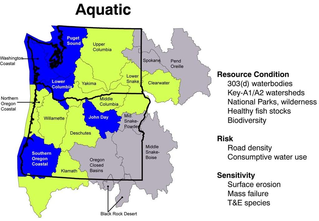
2 I. General Background A prioritization process to identify geographic emphasis areas for restoration work has been developed by the Pacific Northwest Region, Forest Service. It provides an ecological basis for priority setting. The Regional process consists of three modules displaying priorities for aquatic, terrestrial and community/social environments. The modules are designed to operate independently or be combined to produce an integrated priority ranking for basins. These modules have been initially applied at the basin scale (3 rd level hydrologic unit or HUC), to provide information for broad-scale strategic planning. It is anticipated that the general approach and criteria used in the modules will be used at other spatial scales (4 th, 5 th and even 6 th field HUC s) as a basis for developing a consistent, nested strategy for restoration work at all levels in the Pacific NW Region. Increasingly more detailed local data would be used as watershed size decreases. Basic concepts guiding development of the three modules has emphasized analysis of whole basins (not just Federal lands), as well as rating areas in the best relative condition as the highest priority for restoration. II. Aquatic Module Approach The aquatic module considers resource condition, watershed sensitivity, and management-related risk factors in establishing priorities. It addresses ecological needs of at-risk fish stocks, watershed condition and water quality. The underlying approach in developing the model is to utilize quantitative information, using the best data consistently available across the two-state area (Oregon and Washington). The model utilizes the same general methodology developed in the interagency (IIT) Interim Watershed Restoration Strategy, for Biological Opinions in the PACFISH/INFISH areas (May 2000). Please refer to this document for details on derivation of the model. It is included as Appendix A. This Regional model incorporates additional variables for reflecting water quality improvement needs. It also uses some different information than was used in the IIT Restoration Strategy analysis, in an effort to utilize uniform data sets available for the entire two-state area. III. Model Development and Framework The model construction incorporates three primary categories for analysis: 1) Aquatic Resource Condition; 2) Watershed Sensitivity; and 3) Management Intensity. The paradigm of risk reduction in the best basins 1
3 first drives the weighting of the model components from 4 for aquatic resource condition to 1 for watershed integrity. These weights were assigned based on the modelers belief of their relative importance. The model is intended to select for basins with a higher proportion of watersheds in a fully functioning or functioning at risk condition. Among basins with similar condition ratings, the most sensitive are rated highest for treatment, and then among similar groupings, the basins with the greatest amount of risk factors are rated highest. Each of the categories is represented by a series of criteria/indicators. These are both physical and biological for each of the categories. Basins are scored for each indicator and the indicator ratings are ranked to normalize. In an Excel spreadsheet, each indicator ranking is then weighted by multiplying it s relative importance within the category by the reliability of the data high-3, medium 2, and low-1. This results in a possible range of weights for each indicator, ranging from 1-9. The weighted indicator scores within each category for each basin are summed and averaged to produce a weighted average score for the category. The weighted average score for each category is then multiplied by the category weight. The scores for each of the categories are then totaled for each basin. The general logic track followed for model development follows (refer also to Table I): 1. Aquatic Resource Condition: With a weighting of 4, this category is weighted as the most important category in the model. It represents basin condition under existing management regimes. It also infers the potential for detectable response in resources of concern (fish populations, water quality, etc.) to restoration work. It is intended to select for basins with the highest proportion of sub basins/watersheds in functioning or functioning at risk condition. The category uses both physical and biological criteria/indicators. Physical Indicators o Current condition/potential for response: Water quality impaired stream segments o Future status: Land-use (amount of protected/reserved lands) Biological Indicators o General condition: Native biodiversity o Condition/potential for response: Healthy fish stocks 2
4 2. Basin Sensitivity: This category has a weighting of 2. It characterizes the inherent relative sensitivity of the watershed to disturbance using selected risk factors (see #3 below). Physical Indicators o Surface erosion risk o Mass failure risk Biological Indicator o Federally Listed T& E species 3. Management Intensity: This category measures the degree of human impact on the landscape, and is a measure of potential to affect significant change in resource conditions through restoration work. Human-caused disturbance such as road building and consumptive water use are considered risk factors. This is the lowest weighted category and is intended to help sort basins after each basins condition and sensitivity are factored together. o Terrestrial/Watershed Indicator- Road density o Aquatic Indicator (channel condition)- Consumptive water use TABLE I: Aquatic Model Construction 1. Aquatic Resource Condition Indicator Score-> Rank (1-9) X Indicator Weight*= Weighted Rank 303d segments _3 Key watershed % _9 Wild/Parks % _9 Healthy Stocks _6 Biodiversity _6 Condition Category = Sum Indicator Weighted Ranks X 4 (Category Score Sum of Indicator Weights (33) Weight*) 2. Basin Sensitivity Indicator Score->Rank (1-9) X Indicator Weight*= Weighted Rank Surf. Erosion risk _4 Mass failure risk _4 T&E species _3 Sensitivity Category= Sum Indicator Weighted Ranks X 2 (Category Score Sum of Indicator Weights (11) Weight*) 3
5 3. Management Intensity (Risk) Indicator Score->Rank (1-9) X Indicator Weight*=Weighted Rank Road Density 3 Water Use 3 Risk Category = Sum Indicator Weighted Ranks X 1 (Category Score Sum of Indicator Weights (6) Weight*) Total Basin Score = Condition+Sensitivity+Risk Scores *Weighting assignment: Category Weighting- relative importance based on restoration philosophy Indicator Weighting- importance in category times the reliability of the data IV. Criteria description/derivation An attempt was made to use the most robust, ecologically representative, and direct measure for each indicator. In many cases, it was difficult to find complete data sets derived in a consistent fashion that covered both states for preferred indicators. Therefore a different, less directly related indicator was sometimes used. Indicators utilized include: Water Quality/Physical Criteria 1. Number of currently listed 303(d) segments in the basin. 303(d) listed segments identify those water-bodies that are currently not meeting water quality standards and, therefore, are not providing for beneficial uses. Data was taken from an EPA source. No attempt to validate the listings was made. The data is for total number of segments and does not represent miles of impaired segments. 2. Irrigation water use Measures water withdrawal without return flow to streams in million gallons/day water use values were taken from published USGS data. 3. Surface erosion risk Potential for surface erosion was estimated for each basin. A professional panel was convened to qualitatively assign a Very High, High, Moderate, or Low rating to each of 4
6 Omernick s eco-regions (level IV). A GIS query was made to intersect the basin and eco-region maps with a resultant data table showing acres of each eco-region in each basin. A final rating for each basin was determined based on the relative real extent of each erosion class within a basin. 4. Mass failure risk Derived in the same fashion as Surface Erosion, above. 5. Road density Percent of basin with transportation network greater than or equal to 2 miles per sq. mile. A moving windows approach was applied to a GIS layer that contains transportation maps for all ownerships in both Oregon and Washington. The result of the analysis is a tabulation of acres of density classes by ownership by basin. The table, in concert with the spatial arrangement of the densities, provides a good representation of the variability of roads within each basin. Ownership was ignored in the model input. The total area for road networks with density greater than or equal to 2 miles per square mile was totaled for use in the model. Land-use Condition Indicators Two general classes of land-uses were identified as likely to maintain or improve watershed conditions over time: 1. Wilderness and National parks Highly protected lands with relatively limited current and future amounts of human caused disturbance. The percent of each basin s acreage in these lands was calculated. 2. Key Watersheds These are high quality and readily restorable watersheds with high biological fish recovery and/or water quality values. They are the focus areas for protection and restoration efforts on FS and BLM lands. The percent of each basin s acreage allocated to Key watersheds (Northwest Forest Plan, Tier I/Tier II) and/or A1/A2 watersheds (ICBEMP) was calculated. Biological/Fish criteria The three biological criteria utilized include: 5
7 1. Healthy stocks number/status of healthy anadromous fish stocks. Some agencies and interest groups have proposed these stocks as a logical focal point for protection/restoration efforts. The rationale for this index recognizes healthy stocks as indicators of functional habitats. They also infer a relative lack of other significant impacts acting on the populations, which suggests good potential for response from further habitat restoration. The number of species represented by a healthy stock in each basin was taken from Huntington, et al. (1994), Healthy Native Stocks of Anadromous Salmonids in the Pacific Northwest and California. Basins shown with a Healthy Level 1 stock (greater than 2/3 potential productivity for the river system) were given two points; basins with only a Healthy Level 2 stock (10-66% of potential productivity) were given one point. Points for each species were summed to give a total basin score. No attempt was made to verify the information from the source document. (There is no comprehensive information on relative status of resident fish populations available for the two-state area.) 2. Threatened and Endangered Species- number of federal threatened and endangered fish species in each basin. Each listed species is given one point. These are totaled for each basin. Distribution of fish species listed as Endangered or Threatened (or proposed for listing) were taken from Listing Status Maps (see The rationale for the criterion is to reflect the relative risk for loss of fish species, as well as to recognize potential benefits from restoration work to help recover listed species. 3. Biodiversity- number/basin of native salmonid plus rare endemic non-salmonid fish species. Each native salmonid species and each Regionally listed sensitive non-salmonid species was given one point and totaled for each basin. Due to the current lack of consistent, complete information on aquatic biodiversity in the watersheds across Oregon and Washington, the modeling effort utilized two of the more complete data sets available: The number of native salmonid species in each basin and the Pacific NW Region FS Sensitive Species list (which incorporates species listed by both States and Natural Heritage 6
8 V. Sensitivity Testing databases). It was assumed that the diversity of these native species still present in these basins could function as an indicator of aquatic community status, and also reflect the additive benefits for watershed restoration to multiple species. Sources for data were StreamNet GIS maps, USFWS Distinct Population Segment maps, and NOAA Coastal Listing Status Map (see Efforts are underway in both Oregon and Washington to compile general aquatic biodiversity information. When this is available, the model can be updated with more representative criteria. In initial tests of early versions of the model, weighting of the indicators differed from that shown above. Weighting was adjusted for several indicators to provide better balance within the model. Computing weighted average scores for each category also helped to balance the indicators. Subsequent sensitivity testing has shown that results from the present version of the model do not change significantly with small changes to weighting in any of the indicators or categories. VII. Results Values for the indicators in each basin, and the resulting total model scores are displayed in Table II. The basin total scores are shown in Table III. Basins ranking 30 or more were rated as having high ecological priority for restoration. These basins include: Puget Sound, Lower Columbia, Washington Coastal, Southern Oregon Coastal, Northern Oregon Coast, Lower Snake and John Day. Basins ranking were rated moderate, and include Willamette, Klamath, Upper Columbia, Northern California Coastal, Deschutes, Middle Columbia, Clearwater, and Yakima. Basins ranking 22 and below rated low, including Pend Oreille, Middle Snake-Powder, Spokane, Oregon Closed Basins, Middle Snake-Boise, Upper Sacramento and Black Rock Basin. 7
9 TABLE II: Basin Criteria and Category Scores Resource Condition Basin Name 303(d) key WS NP/wild healthy stk biodivers. Wtd. Rank Black Rock Basin Pend Oreille Spokane Upper Columbia Yakima Middle Snake-Boise Middle Snake-Powder Lower Snake Clearwater Middle Columbia John Day Deschutes Lower Columbia Willamette Washington Coastal Northern Oregon Coastal Southern Oregon Coastal Puget Sound Oregon Closed Basins Northern California Coastal Klamath Upper Sacramento importance data reliability criteria wt Risk Basin Name roads water use Black Rock Basin Pend Oreille Spokane Upper Columbia Yakima Middle Snake-Boise Middle Snake-Powder Lower Snake Clearwater Middle Columbia John Day
10 Deschutes Lower Columbia Willamette Washington Coastal Northern Oregon Coastal Southern Oregon Coastal Puget Sound Oregon Closed Basins Northern California Coastal Klamath Upper Sacramento importance 1 1 data reliability 3 3 criteria wt Sensitivity Basin Name sfc eros. mass fail T&E Black Rock Basin Pend Oreille Spokane Upper Columbia Yakima Middle Snake-Boise Middle Snake-Powder Lower Snake Clearwater Middle Columbia John Day Deschutes Lower Columbia Willamette Washington Coastal Northern Oregon Coastal Southern Oregon Coastal Puget Sound Oregon Closed Basins Northern California Coastal Klamath Upper Sacramento importance data reliability criteria wt
11 TABLE III: Total Basin Scores, Aquatic Restoration Priority Model Cond. Risk Sens. total Black Rock Basin Pend Oreille Spokane Upper Columbia Yakima Middle Snake-Boise Middle Snake-Powder Lower Snake Clearwater Middle Columbia John Day Deschutes Lower Columbia Willamette Washington Coastal Northern Oregon Coastal Southern Oregon Coastal Puget Sound Oregon Closed Basins Northern California Coastal Klamath Upper Sacramento
12 Northern California Coastal Klamath Upper Sacramento Yakima Middle Snake-Boise Middle Snake-Powder Lower Snake Clearwater Middle Columbia John Day Deschutes Lower Columbia Willamette Washington Coastal Northern Oregon Coastal Southern Oregon Coastal Puget Sound Oregon Closed Basins Upper Columbia Table IV. TOTAL BASIN SCORES, Aquatic Restoration Priority Model 11 Spokane Black Rock Basin Pend Oreille
13 12
ENVIRONMENTAL CONSIDERATIONS FOR EVALUATING INTERBASIN WATER TRANSFERS IN GEORGIA
 ENVIRONMENTAL CONSIDERATIONS FOR EVALUATING INTERBASIN WATER TRANSFERS IN GEORGIA Nolton G. Johnson, Steven R. Layman, and Cristin C. Krachon AUTHORS: Geosyntec Consultants, 1255 Roberts Blvd NW, Suite
Effectiveness Monitoring Gap Analysis and Prioritization. Jennifer O Neal - Project Manager Tetra Tech EC, Inc.
 Effectiveness Monitoring Gap Analysis and Prioritization Jennifer O Neal - Project Manager Tetra Tech EC, Inc. Overview Project Background Project Approach Methods Results Recommendations Summary Additional
Facts About Pesticides, Salmon, and the Endangered Species Act
 Facts About Pesticides, Salmon, and the Endangered Species Act Background Information on Pesticides and Salmon Pesticides have profound effects on Northwest salmon and may be a serious factor in their
Tim Hayden, Yurok Tribe Natural Resources Division Mat Millenbach, Western Rivers Conservancy Sarah Beesley, Yurok Tribal Fisheries Program
 BLUE CREEK FOREST SANCTUARY: RESTORING OLD GROWTH FOREST ECOSYSTEM FUNCTION, PROTECTING SALMON, WILDLIFE, AND TRADITIONAL- LIFE WAYS AND CULTURE IN THE FACE OF CLIMATE CHANGE Tim Hayden, Yurok Tribe Natural
CALFED Ecosystem Restoration Program (ERP)
") CALFED Ecosystem Restoration Program (ERP) The goal of the Ecosystem Restoration Program is to improve and increase aquatic and terrestrial habitats and improve ecological functions in the Bay-Delta to
CALFED Ecosystem Restoration Program (ERP) The goal of the Ecosystem Restoration Program is to improve and increase aquatic and terrestrial habitats and improve ecological functions in the Bay-Delta to
LAWSUIT TO PROTECT SALMON FROM PESTICIDES UNDER THE ENDANGERED SPECIES ACT
 LAWSUIT TO PROTECT SALMON FROM PESTICIDES UNDER THE ENDANGERED SPECIES ACT Background Information on Pesticides and Salmon Pesticides have profound effects on Northwest salmon and may be a serious factor
Examines condition of nearshore habitats in Oakland Bay and Hammersley Inlet and identifies priority areas for conservation and restoration that will
 1 Examines condition of nearshore habitats in Oakland Bay and Hammersley Inlet and identifies priority areas for conservation and restoration that will support the recovery of salmonids. Assessment geared
Little River Watershed Restoration Project. Mark Powell, Consultant Natural Resources Management
 Little River Watershed Restoration Project Mark Powell, Consultant Natural Resources Management Lessons Learned Strong partnerships RC&D, Soil and Water, 2 counties, Albemarle Commission, Universities,
Modeling the Effects of Agricultural Conservation Practices on Water Quality in the Pacific Northwest Basin
 Modeling the Effects of Agricultural Conservation Practices on Water Quality in the Pacific Northwest Basin Presenter: R. Srinivasan, Professor, Texas A&M C. Santhi and CEAP National Assessment Team Texas
National Marine Fisheries Service ESA/MSA Restoration Project Consultations. Oregon State Habitat Office Oregon Coast Branch Roseburg, Oregon
 National Marine Fisheries Service ESA/MSA Restoration Project Consultations Ken Phippen Jeff Young Oregon State Habitat Office Oregon Coast Branch Roseburg, Oregon NMFS Consultation Authorities Endangered
Forest Plan Amendment to Remove the Layng Creek Municipal Watershed Management Plan
 United States Department of Agriculture Forest Service Forest Plan Amendment to Remove the Layng Creek Municipal Watershed Management Plan Draft Decision Memo Umpqua National Forest Cottage Grove Ranger
NetMap Community Digital Watersheds & Shared Analysis Tools
 NetMap Community Digital Watersheds & Shared Analysis Tools Earth Systems Institute U. S. Forest Service, Pacific Northwest Experiment Station & Collaborating Agencies The NetMap Project Collaborators:
DECISION RECORD for the Rattlesnake Negotiated Timber Sale (Reference:
 DECISION RECORD for the Rattlesnake Negotiated Timber Sale (Reference: Bly Mtn. / Swan Lake / Rattlesnake Reservoir Forest Health and Woodland Treatments Environmental Assessment #OR014-99-6) Introduction
The status of aquatic ecosystems in the Basin
 AQUATIC SPECIES AND HABITATS The status of aquatic ecosystems in the Basin is influenced by both natural and human processes. The geologic and geomorphic processes described earlier formed and continue
EXHIBIT B. Service Areas. Aquatic Resource Service Area. Vernal Pool Service Area. Service Area Narrative
 EXHIBIT B Service Areas Aquatic Resource Service Area Vernal Pool Service Area Service Area Narrative Exhibit B Service Area Narrative The ILF Program Area is defined as the jurisdictional limits of the
Agency Organization Organization Address Information. Name United States Department of Agriculture
 Logo Department Name United States Department of Agriculture Agency Organization Organization Address Information Forest Service Pacific Northwest Region 1220 SW Third Avenue (97204) P.O. Box 3623 Portland,
CHESAPEAKE BAY COMPREHENSIVE WATER RESOURCES AND RESTORATION PLAN. Habitat GIT Meeting 9 May 2017
 CHESAPEAKE BAY COMPREHENSIVE WATER RESOURCES AND 255 255 255 237 237 237 0 0 0 217 217 217 163 163 163 200 200 200 131 132 122 239 65 53 80 119 27 RESTORATION PLAN 110 135 120 252 174.59 112 92 56 62 102
Results for the Puget Sound
 Northwest Forest Plan -The First 15 Years (1994-2008) Watershed Condition Status and Trend Results for the Puget Sound Steve Lanigan, Sean Gordon, Peter Eldred, Stephanie Miller July, 2013 The Northwest
Wildlife Habitat Restoration and Improvements FY 2007 Project
 United States Department of Agriculture Forest Service Pacific Northwest Region Wildlife Habitat Restoration and Improvements FY 2007 Project Umpqua National Forest Diamond Lake Ranger District April 2008
Endangered Species Act: Federal Nexus and Consultations on Floodplain Mapping. Skagit River flood1995, Allen Kam, NOAA
 Endangered Species Act: Federal Nexus and Consultations on Floodplain Mapping Skagit River flood1995, Allen Kam, NOAA Presentation Overview Endangered Species Act; Purpose and Requirements for Consultation
Meacham Creek Restoration Project
 Meacham Creek Restoration Project Meacham Creek Restoration Project Umatilla National Forest Walla Walla Ranger District Michael Rassbach, District Ranger Public Scoping Document Proposal Summary The Walla
Watershed Approach to Recovering Urban Streams: Developing and Implementing a Watershed Management Plan STEVE HITCH, PE CITY OF REDMOND
 Watershed Approach to Recovering Urban Streams: Developing and Implementing a Watershed Management Plan STEVE HITCH, PE CITY OF REDMOND 1 Puget Sound Salmon 2 Puget Sound Salmon Healthy aquatic habitat
Riparian Forest Buffer Restoration Targeting
 Riparian Forest Buffer Restoration Targeting for the York River Watershed By Anne Newsom, Carl Hershner, and Dan Schatt Introduction A little over three hundred years ago, more than ninety-five percent
LIVING LANDS Helping Land Trusts Conserve Biodiversity
 LIVING LANDS Helping Land Trusts Conserve Biodiversity Habitat Restoration: Information for Land Trusts What is Habitat Restoration? Habitat restoration is defined as the process of assisting the recovery
Protecting & Restoring Local Waters and the Chesapeake Bay
 Protecting & Restoring Local Waters and the Chesapeake Bay Restore America s Estuaries National Conference Gregory Barranco Chesapeake Bay Program Office November 2010 The Chesapeake Bay and Watershed
Critical Areas Ordinance
 Public Review Draft //7 Public Review Draft //7 4 5 6 Kitsap County Code Title 9 Critical Areas Ordinance 7 8 9 0 Underline / Strike out Version 9.800 Appendices 4 5 6 7 8 9 0 4 5 Public Review Draft //7
Federal Guide for Watershed Analysis
 Federal Guide for Watershed Analysis Revised August 1995 Version 2.2 For copies of this document, please contact: Regional Ecosystem Office P.O. Box 3623 Portland, Oregon 97208-3623 Portland, Oregon This
Pacific Lamprey Conservation Initiative- Focus on Willamette Subregion
 Pacific Lamprey Conservation Initiative- Focus on Willamette Subregion Christina Luzier and Howard Schaller Columbia River Fisheries Program Office US Fish & Wildlife Service Global Distribution Historically
Further information of project proposals is available on the World Wide Web at:
 United States Department of Agriculture Forest Service Newport/Sullivan Lake Ranger Districts 315 North Warren Newport, WA 99156 509-447-7300 FAX: 509-447-7301 File Code: 1950 Date: February 7, 2014 Dear
APPENDIX B EFFECTS TO PHYSICAL AND BIOLOGICAL ENVIRONMENT
 APPENDIX B EFFECTS TO PHYSICAL AND BIOLOGICAL ENVIRONMENT Botany No known proposed, endangered, threatened, and sensitive vascular plant, bryophyte, lichen and fungi (PETS) species are present within the
Resource Management Plans for Western Oregon
 Resource Management Plans for Western Oregon Bureau of Land Management Includes: Background, Timeline and NEPA Planning Steps, and the full text of the. The proposed action is to revise the current resource
FINDING COMMON THREADS FOR RESTORING THE COLUMBIA RIVER ECOSYSTEM THROUGH SALMON AND STEELHEAD RECOVERY
 FINDING COMMON THREADS FOR RESTORING THE COLUMBIA RIVER ECOSYSTEM THROUGH SALMON AND STEELHEAD RECOVERY National Conference on Ecosystem Restoration July 29, 2013 Elizabeth Holmes Gaar NOAA Fisheries,
Decision Notice and Finding of No Significant Impact
 Decision Notice and Finding of No Significant Impact Indigo and Middle Fork Willamette Enhancement Project USDA Forest Service Middle Fork Ranger District Willamette National Forest Lane County, Oregon
Summary of the 1997 Fish Habitat Risk Assessment Panel
 United States Department of Agriculture Forest Service Tongass National Forest Forest Plan Interdisciplinary Team 8465 Old Dairy Road Juneau, Alaska 99801 (907) 586-8700 Reply To: RS-G-b Date: May 7, 1997
A GIS Tool Prioritizing Dams for Removal within the State of North Carolina Kat Hoenke Southeast Aquatic Resources Partnership (SARP)
") A GIS Tool Prioritizing Dams for Removal within the State of North Carolina Kat Hoenke Southeast Aquatic Resources Partnership (SARP) Cape Fear River Partnership Meeting May 15-16, 2014 Project Background
A GIS Tool Prioritizing Dams for Removal within the State of North Carolina Kat Hoenke Southeast Aquatic Resources Partnership (SARP) Cape Fear River Partnership Meeting May 15-16, 2014 Project Background
Forest Plan Monitoring Program Frequently Asked Questions
 U.S. Forest Service Pacific Southwest Region June 2016 Forest Plan Monitoring Program Frequently Asked Questions What is the forest plan monitoring program? The monitoring program is one of three phases
Climate Change Adaptation: Moving From Plans to Action on the South Fork Nooksack River, WA
 Climate Change Adaptation: Moving From Plans to Action on the South Fork Nooksack River, WA Presentation to: River Restoration Northwest Symposium 2017 Skamania Lodge, WA February 6-9, 2017 Oliver J. Grah
CLEAN WATER ACT SECTION 303(d) (TMDLs) The detail for TMDL activities from 1998 through 2002 appears as Table 2
 (TMDLs) The detail for TMDL activities from 1998 through 2002 appears as Table 2") 1 CLEAN WATER ACT SECTION 303(d) (TMDLs) Section 303(d) of the Clean Water Act requires biennial listing of waterbodies not meeting water quality standards and prioritization of those waterbodies for waste
1 CLEAN WATER ACT SECTION 303(d) (TMDLs) Section 303(d) of the Clean Water Act requires biennial listing of waterbodies not meeting water quality standards and prioritization of those waterbodies for waste
Habitat Coverage Targets for the Lower Columbia River - How Much is Enough?
 Habitat Coverage Targets for the Lower Columbia River - How Much is Enough? Catherine Corbett November 2013 Ecosystem-Based Management (EBM) Requires these conditions (UNEP 2006): holistic vision/plan
Impacts of 2015 Drought on Streamflow in the Columbia River Basin
 Impacts of 2015 Drought on Streamflow in the Columbia River Basin Chris Konrad US Geological Survey Tacoma, WA May 11, 2016 1 Overview of USGS Investigation Western US had low snowpack, warm temperatures,
INTERIOR S PLAN FOR A COORDINATED, SCIENCE-BASED RESPONSE TO CLIMATE CHANGE IMPACTS ON OUR LAND, WATER, and WILDLIFE RESOURCES
 U.S. Department of the Interior INTERIOR S PLAN FOR A COORDINATED, SCIENCE-BASED RESPONSE TO CLIMATE CHANGE IMPACTS ON OUR LAND, WATER, and WILDLIFE RESOURCES SUMMARY Climate change is driving rapid and
New Hampshire s Wildlife Habitat Conditions
 CHAPTER THREE New Hampshire s Wildlife Habitat Conditions Abstract Wildlife habitat condition was assessed for all 27 habitat types. NHFG developed a methodology to assess the relative ecological condition
DRINKING WATER PROVIDERS PARTNERSHIP
 DRINKING WATER PROVIDERS PARTNERSHIP 2017 Request for Proposals (RFP) V. November 15, 2016 Proposal Deadline is 17 January 2017 at 5:00PM Pacific Time Award announcements will be made in March 2017 Download
Appendix B Stream Database
 Appendix B Stream Database This product was financed through a grant from the Ohio Environmental Protection Agency and the United States Environmental Protection Agency with funds from Section 604B of
Wildlife Conservation Strategy
 Wildlife Conservation Strategy Boise National Forest What is the Wildlife Conservation Strategy? The Boise National Forest is developing a Wildlife Conservation Strategy (WCS) in accordance with its Land
Building a Strong Tribal Partnership with the Nooksack Indian Tribe for Climate Resilience and Salmon Recovery in the South Fork Nooksack River, WA
 Building a Strong Tribal Partnership with the Nooksack Indian Tribe for Climate Resilience and Salmon Recovery in the South Fork Nooksack River, WA Presentation to: Future of Our Salmon Workshop 2016 Spokane,
FACT SHEET: BLM, USFS Greater Sage-Grouse Conservation Effort
 EMBARGOED UNTIL SEPTEMBER 22, 2015 @ 12:00PM ET FACT SHEET: BLM, USFS Greater Sage-Grouse Conservation Effort Overview Effective conservation of the greater sage-grouse and its habitat requires a collaborative,
Applying Ecosystem Services to Collaborative Forest Management Elk River Public Meeting
 Applying Ecosystem Services to Collaborative Forest Management Elk River Public Meeting Nikola Smith Ecologist and Ecosystem Services Specialist U.S. Forest Service Port Orford City Hall February 2, 2017
July 28, OVERVIEW: Lower Clearwater Exchange Project (Idaho)
") Bruce A. Measure Chair Montana Rhonda Whiting Montana W. Bill Booth Idaho James A. Yost Idaho Joan M. Dukes Vice-Chair Oregon Bill Bradbury Oregon Tom Karier Washington Phil Rockefeller Washington July
Bruce A. Measure Chair Montana Rhonda Whiting Montana W. Bill Booth Idaho James A. Yost Idaho Joan M. Dukes Vice-Chair Oregon Bill Bradbury Oregon Tom Karier Washington Phil Rockefeller Washington July
Tim Walls, Snohomish County Public Works
 Tim Walls, Snohomish County Public Works Collaborators: Janne Kaje, King County Krista Bartz, NOAA Northwest Fisheries Science Center Abby Hook, Tulalip Tribes Basic basin facts why unique? Why salmon
Columbia River Basin Monitoring, Evaluation, Research, and Reporting (MERR) Plan
 Plan") Columbia River Basin Monitoring, Evaluation, Research, and Reporting (MERR) Plan Council document 2010-4 Executive Summary This Monitoring, Evaluation, Research and Reporting Plan (MERR Plan) ensures the
Columbia River Basin Monitoring, Evaluation, Research, and Reporting (MERR) Plan Council document 2010-4 Executive Summary This Monitoring, Evaluation, Research and Reporting Plan (MERR Plan) ensures the
Watershed Analysis for Mendocino Redwood Company s Ownership in the Gualala River Watershed
 Watershed Analysis for Mendocino Redwood Company s Ownership in the Gualala River Watershed INTRODUCTION This report presents the results of a watershed analysis performed by Mendocino Redwood Company
Adapting to Climate Change in Western National Forests
 Adapting to Climate Change in Western National Forests David L. Peterson 1, Jessica E. Halofsky 2, Natalie Little 3 ¹USDA Forest Service, Pacific Northwest Research Station ²University of Washington, School
Hydrology. Section C. Introduction
 Section C Hydrology Introduction This section provides the available hydrologic data for the and some analysis of the bed mobility in response reaches of the WAU. The does not receive any significant snow
February 4, Erik Merrill, ISAB Coordinator; Jim Ruff, ISAB Ex Officio; and Laura Robinson, Program Implementation and Liaison Specialist
 Bill Bradbury Chair Oregon Henry Lorenzen Oregon W. Bill Booth Idaho James A. Yost Idaho Jennifer Anders Vice Chair Montana Pat Smith Montana Tom Karier Washington Phil Rockefeller Washington February
GREAT BASIN ENVIRONMENTAL PROGRAM
 GREAT BASIN ENVIRONMENTAL PROGRAM A Multi-state Partnership to Improve Land Health and Ecosystem Productivity NEVADA UTAH IDAHO OREGON CALIFORNIA Summary FOCUS: INVASIVE PLANT SPECIES Wildfires Water Resources
Cedar River Watershed Habitat Conservation Plan
 Cedar River Watershed Habitat Conservation Plan Briefing for the WRIA 8 Salmon Recovery Council November 21, 2013 Cyndy Holtz Seattle Public Utilities cyndy.holtz@seattle.gov What is an HCP? Habitat Conservation
I. INTRODUCTION PURPOSE BASIN DESCRIPTION WATER RESOURCES DEVELOPMENT TYPES OF RESERVOIR PROJECTS ANNUAL REGULATION CYCLE
 I. INTRODUCTION PURPOSE BASIN DESCRIPTION WATER RESOURCES DEVELOPMENT TYPES OF RESERVOIR PROJECTS ANNUAL REGULATION CYCLE A. PURPOSE This document reports on the activities of concerned governmental agencies
Prioritizing Local Action. Strengthening the Resilience of the Taunton River Watershed
 Prioritizing Local Action Strengthening the Resilience of the Taunton River Watershed No Really, We re Here to Help 6/12/14 Healthy and Resilient Taunton Watershed Project EPA s Healthy Watershed Program
Implementation of a Tiered Aquatic Life Use Framework for Minnesota Streams
 Implementation of a Tiered Aquatic Life Use Framework for Minnesota Streams June 13, 2012 New Text wq-ppt3-02 Minnesota Pollution Control Agency St. Paul, MN Stream Diversity in Minnesota Forest Mixed
Climate Change Adaptation: Great Lakes region examples
 Climate Change Adaptation: Great Lakes region examples Kimberly Hall kimberly_hall@tnc.org Credits: IPCC 2007, Photos Photography Plus, Julie Craves Mark Godfrey October 21, 2010 Freshwater Future CC Workshop,
The GRAIP model is a product of work we have been doing on roads for a number of years in Oregon and Idaho. We have had help with the GIS tools from
 The GRAIP model is a product of work we have been doing on roads for a number of years in Oregon and Idaho. We have had help with the GIS tools from Dave and Ajay at Utah State. The Boise NF contributed
1:24K Fish Habitat Distribution Development Project. Data Format Outlines and Data Compilation Protocols
 1:24K Fish Habitat Distribution Development Project Data Format Outlines and Data Compilation Protocols Information Workshop, Salem, Oregon May 8, 2001 Fish Habitat Distribution Data Outline A. Data description:
Watershed Condition Status and Trend
 Northwest Forest Plan The First 15 Years (1994 2008) Watershed Condition Status and Trend Steven H. Lanigan, Sean N. Gordon, Peter Eldred, Mark Isley, Steve Wilcox, Chris Moyer, and Heidi Andersen General
CHESAPEAKE BAY COMPREHENSIVE WATER RESOURCES AND RESTORATION PLAN - UPDATE. Update to Chesapeake Bay Program STAR January 25, 2018
 CHESAPEAKE BAY COMPREHENSIVE WATER RESOURCES AND RESTORATION 255 255 255 237 237 237 0 0 0 217 217 217 163 163 163 200 200 200 PLAN - UPDATE 131 132 122 239 65 53 80 119 27 110 135 120 252 174.59 112 92
Forest Stewardship Spatial Analysis Project Illinois Methodology March, 2007
 Forest Stewardship Spatial Analysis Project Illinois Methodology March, 2007 Project Summary Administered by the U.S. Forest Service and implemented by State forestry agencies, the Forest Stewardship Program
Watershed Health Assessment Framework. Watershed Report Card:
 Watershed Health Assessment Framework "Managing for System Health" Watershed Report Card: People and Places: Watershed Population: 2 census - 1, 21 census - 1,7 Largest Cities - Population: Blackduck -
THINKING LIKE A WATERSHED. Using a Watershed Approach to Improve Wetland and Stream Restoration Outcomes
 THINKING LIKE A WATERSHED Using a Watershed Approach to Improve Wetland and Stream Restoration Outcomes Project Overview: The Watershed Approach to Compensatory Mitigation Site selection should follow
Chapter Three: Discussion and Conclusion. 3.1 Introduction/Overview. 3.2 Countywide Stream Assessment
 3.1 Introduction/Overview The objective of this study was to develop a stream prioritization tool that evaluates stream reaches in terms of the potential water quality improvements that could be achieved
Acres 32% 35% Not Suitable. Impervious. Possible UTC. Vegetation. Existing UTC
 Acres A Report on Washington, D.C. s Urban Tree Canopy Why is Tree Canopy Important? Urban tree canopy (UTC) is the layer of leaves, branches, and stems of trees that cover the ground when viewed from
ENVIRONMENTAL ASSESSMENT
 ENVIRONMENTAL ASSESSMENT, FINDING OF NO SIGNIFICANT IMPACT, and DECISION RECORD 1 ENVIRONMENTAL ASSESSMENT EA Number: OR-080-05-10 BLM Office: Marys Peak Resource Area, Salem District Office 1717 Fabry
PLANT AND ANIMAL DIVERSITY
 by the planning rule team as of. These ideas are for discussion purposes and do not What we want to achieve PLANT AND ANIMAL DIVERSITY The Forest Service is committed to protecting species and sustaining
April 5th Meeting Agenda
 Pend Oreille County Voluntary Stewardship Program April 5th Meeting Agenda Welcome and Meeting Overview Follow up from last Work Group meeting Review details in Sections 2 and 3 prepared since last meeting
TAC CHARRETTE WORKBOOK Ecosystem Management and Sustainable Forestry Practices
 For Discussion Purposes TAC CHARRETTE WORKBOOK Ecosystem Management and Sustainable Forestry Practices NEW JERSEY HIGHLANDS COUNCIL March 28, 2006 1 Overview of RMP Goals and Structure NEW JERSEY HIGHLANDS
November 16, SUBJECT: Council s Regional Hydropower Potential Scoping Study
 Bill Bradbury Chair Oregon Henry Lorenzen Oregon W. Bill Booth Idaho James A. Yost Idaho Jennifer Anders Vice Chair Montana Pat Smith Montana Tom Karier Washington Phil Rockefeller Washington November
Funding Guidelines State Fiscal Year 2016
 State Fiscal Year 2016 Water Quality Financial Assistance Centennial Clean Water Program Clean Water Act Section 319 Program Stormwater Financial Assistance Program Washington State Water Pollution Control
Staff summary of Issues & Recommendations Protected Areas
 Staff summary of Issues & Recommendations Protected Areas *Preliminary draft, please refer to full recommendations for complete review 10/29/2013 10:06 AM 2009 Fish and Wildlfe Program Section Section
Relationship to E Flows
 Relationship to E Flows Riparian Areas Influences groundwater/surface water relationships Provides filters to improve water quality Provides habitat for diverse flora and fauna Relationship to E Flows
NATIONAL STREAM AND AQUATIC ECOLOGY CENTER
 NATIONAL STREAM AND AQUATIC ECOLOGY CENTER The National Stream and Aquatic Ecology Center is a technology transfer unit of the National Forest System (NFS) Watershed, Fish, Wildlife, Air and Rare Plants
Nehalem River Watershed Assessment 1
 Nehalem River Watershed Assessment 1 1.0 Introduction Purpose Watershed assessment is a process for evaluating how well a watershed is working. The purpose of this assessment was to determine how natural
Final Decision Memo. Murphy Meadow Restoration Project. USDA Forest Service Willamette National Forest McKenzie River Ranger District
 Final Decision Memo Murphy Meadow Restoration Project USDA Forest Service Willamette National Forest McKenzie River Ranger District T19S, R5E, Sec. 23, 24. Lane County Oregon BACKGROUND The Murphy Meadow
Central Washington 2012 Wildfires Burned Area Emergency Response (BAER) Information Brief October 19, 2012 BAER Information: (208)
 Information Brief October 19, 2012 BAER Information: (208)") Okanogan-Wenatchee National Forest Central Washington 2012 Wildfires Burned Area Emergency Response (BAER) Information Brief October 19, 2012 BAER Information: (208) 398-3348 Fire Background WENATCHEE
Okanogan-Wenatchee National Forest Central Washington 2012 Wildfires Burned Area Emergency Response (BAER) Information Brief October 19, 2012 BAER Information: (208) 398-3348 Fire Background WENATCHEE
Appendix K. Project Opportunity Scoring Worksheet and Web Map References
 Appendix K Project Opportunity Scoring Worksheet and Web Map References Project Opportunity Scoring Sheet ARB SWRP Project Opportunity Matrix and Scoring Worksheet Project Name (Enter Title of Your Choice)
DECISION MEMO. Griz Thin (Stand )
") Background DECISION MEMO Griz Thin (Stand 507089) USDA Forest Service Siuslaw National Forest Central Coast Ranger District Lane County, Oregon Township 16 South, Range 10 West, Sections 6 and 7 The Cummins-Tenmile
Background DECISION MEMO Griz Thin (Stand 507089) USDA Forest Service Siuslaw National Forest Central Coast Ranger District Lane County, Oregon Township 16 South, Range 10 West, Sections 6 and 7 The Cummins-Tenmile
Criteria for Identifying and Prioritizing Habitat Protection and Restoration Projects on the Lower Columbia River and Estuary*
 Criteria for Identifying and Prioritizing Habitat Protection and Restoration Projects on the Lower Columbia River and Estuary* Ecosystem Criteria 1) Habitat Connectivity (0-10 points) This criterion recognizes
River restoration in US and Europe: Interviews with two of our conference keynote speakers
 River restoration in US and Europe: Interviews with two of our conference keynote speakers Dr. Phil Roni and Dr. Stan Gregory were interviewed during the REFORM Final Conference and shared their views
MUCKLESHOOT INDIAN TRIBE Fisheries Division nd Avenue SE Auburn, Washington
 MUCKLESHOOT INDIAN TRIBE Fisheries Division 39015-172 nd Avenue SE Auburn, Washington 98092-9763 Phone: (253) 939-3311 Fax: (253) 931-0752 Scott Sissons Pierce County Planning and Land Services 2401 South
Management Perspectives: Kate Day and Caty Clifton. Blue Mountains Adaptation Workshop, April 23, 2014 La Grande, OR
 Management Perspectives: Kate Day and Caty Clifton Blue Mountains Adaptation Workshop, April 23, 2014 La Grande, OR Top Down Flow sensitivity VIC peak and low flow model projections (Wenger et al) Bottom
Vegetation treatment projects for
 Burning Questions for Managers: Fuels Management Practices in Riparian Areas Riparian Management Services LLC Kristen E. Meyer, Kathleen A. Dwire, Patricia A. Champ, Sandra E. Ryan, Gregg M. Riegel, and
BEFORE THE OREGON ENVIRONMENTAL QUALITY COMMISSION
 BEFORE THE OREGON ENVIRONMENTAL QUALITY COMMISSION I. Introduction Petition to Initiate Rulemaking and Take Other Actions to Protect Existing and Designated Uses of Fish and Wildlife From Point and Nonpoint
Wildlife Conservation Society Climate Adaptation Fund 2014 Restoring Oak Resilience at the Table Rocks, Rogue River Basin, Oregon FACT SHEET
 Wildlife Conservation Society Climate Adaptation Fund 2014 Restoring Oak Resilience at the Table Rocks, Rogue River Basin, Oregon FACT SHEET Project Overview Oak ecosystems in the Pacific Northwest exist
Peter H. Singleton John F. Lehmkuhl. USDA Forest Service Pacific Northwest Research Station Wenatchee Forestry Sciences Lab
 Peter H. Singleton John F. Lehmkuhl USDA Forest Service Pacific Northwest Research Station Wenatchee Forestry Sciences Lab Talk Overview: Wildlife community associated with MMC Considerations for wildlife
Management of Natural and Environmental Resources for Sustainable Agricultural Development. Regional Diversity & Change over the Pacific Northwest
 Management of Natural and Environmental Resources for Sustainable Agricultural Development Regional Diversity & Change over the Pacific Northwest (Maritime, Rangeland, Riparian, Desert, and Forest) By
Request for Proposal Scope Development Guide. Asotin County Geomorphic Assessment. and. Conceptual Restoration Plan
 Request for Proposal Scope Development Guide Asotin County Geomorphic Assessment and Conceptual Restoration Plan Asotin County Conservation District December 3, 2015 1 1.0 INTRODUCTION The Asotin County
Landscape Analysis for Forest Conservation Planning. June 2005, Toronto FPAC/ WWF Technology Transfer Workshop
 Landscape Analysis for Forest Conservation Planning June 2005, Toronto FPAC/ WWF Technology Transfer Workshop Presentation Overview WWF overview Forest statistics the case for forest conservation Market
Multiple wildfires over the last 15 years have created a large need for reforestation. The. Pike National Forest
 Pike National Forest SOUTH PLATTE RANGER DISTRICT, COLORADO April 2018 planting timeline 25,000 trees funded by Enterprise Continued support for reforestation efforts that rely on partnership dollars to
1792/5400 (OR-120) Umpqua River Sawyer Rapids EA OR Purdy Creek DM OR120-TS Dear Citizen:
 Umpqua River Sawyer Rapids EA OR Purdy Creek DM OR120-TS Dear Citizen:") United States Department of the Interior BUREAU OF LAND MANAGEMENT COOS BAY DISTRICT OFFICE 1300 AIRPORT LANE, NORTH BEND, OR 97459 Web Address: http://www.blm.gov/or/districts/coosbay E-mail: OR_CoosBay_Mail@
United States Department of the Interior BUREAU OF LAND MANAGEMENT COOS BAY DISTRICT OFFICE 1300 AIRPORT LANE, NORTH BEND, OR 97459 Web Address: http://www.blm.gov/or/districts/coosbay E-mail: OR_CoosBay_Mail@
Session C7- Building on the $10 million/year H TAP program for culvert mitigation on national forest system lands
 University of Massachusetts - Amherst ScholarWorks@UMass Amherst International Conference on Engineering and Ecohydrology for Fish Passage International Conference on Engineering and Ecohydrology for Fish
Science Plan. Executive Summary. Introduction
 Science Plan Executive Summary This Science Plan will establish and define the focus of the Peninsular Florida Landscape Conservation Cooperative (PFLCC) science investments. The data and products derived
Prioritization Framework For Management Strategies in the Entiat Subbasin Plan
 Prioritization Framework For Management Strategies in the Entiat Subbasin Plan November, 2004 Co-Planners: Chelan County Yakama Nation Prepared by Introduction The purpose of this report is to provide