IDT Discussions on HRM Expansion Compiled on April 10, 2014
|
|
|
- Prudence Jefferson
- 6 years ago
- Views:
Transcription
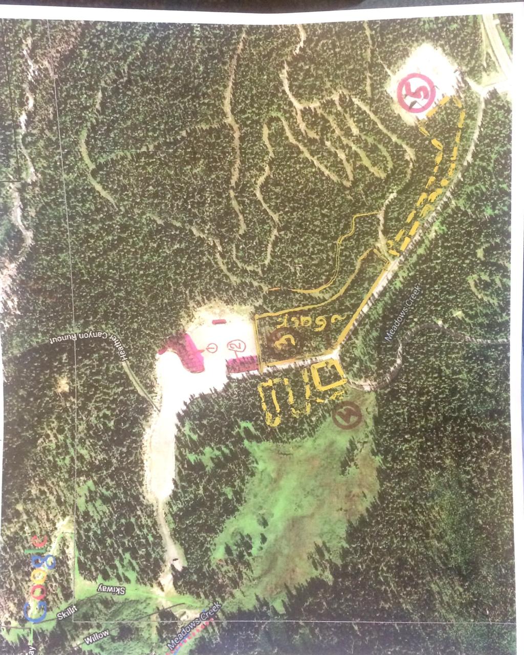
1 IDT Discussions on HRM Expansion Compiled on April 10, 2014 IDT identified that Alternative 4 would fully address the cross-country skiing issues that were raised. The alternative locations suggested in the scoping comments were proposed so as not to impact the Hanel and Little loops (9/21/2011 IDT notes). Three locations were considered, including an expansion of the Hood River Meadows (HRM) Parking Lot First preference would be to build out the existing HRM parking lot. The new parking lot could be 8-acres, plus storm water management and snow removal, in the existing plantations. This first preference is the same general location of Joe s proposal (see Map 1). After field work had been completed, the IDT discussed the alternatives again to minimize the impacts to cross-country skiing on 11/9/2011: HRM Parking Lot Expansion Alternative: Perhaps we could analyze this alternative in detail if dropping Alternative 4 (Bear Grass Loop Alternative). However, the drain field potentially would have to be moved or the new parking lot would have be located outside the drain field area. The drain fields are located on the eastside of the parking lot, outside the current proposal (see attached Map 2). Monitoring wells are co-located with the drain field. This alternative was concerned, but eliminated from detailed study. EIS section states: This alternative would build out the existing Hood River Meadows (HRM) parking lot to improve parking capacity, rather than constructing a separate parking lot. The parking lot could be expanded into the existing plantations. This alternative would minimize the new disturbance because it would utilize the snow storage and storm water management associated with the existing parking lot. The existing parking lot is 8.0 acres, plus an additional 4.2 acres for snow storage and storm water management. The parking lot has a capacity of 976 vehicles (122 vehicles per acre). This alternative was proposed by both the interdisciplinary team as well as members of the public during the scoping period that was conducted in August Field reviews and discussions with MHM revealed that the area proposed for the parking lot include a septic drainage field, consisting of three or four drain lines that are snaked through the trees. This septic system services the current Nordic skier services building septic tank. Moving the drainage field to accommodate this alternative would be cost prohibitive, and would result in additional acres of disturbance because the drainage field would have to be relocated. As such, this alternative is not reasonably feasible or viable and was not considered in detail. In reviewing Joe s proposal, issues were raised related to wildlife, cultural resources, recreation, and aquatics. The primary resource concern is related to northern spotted owls. 1
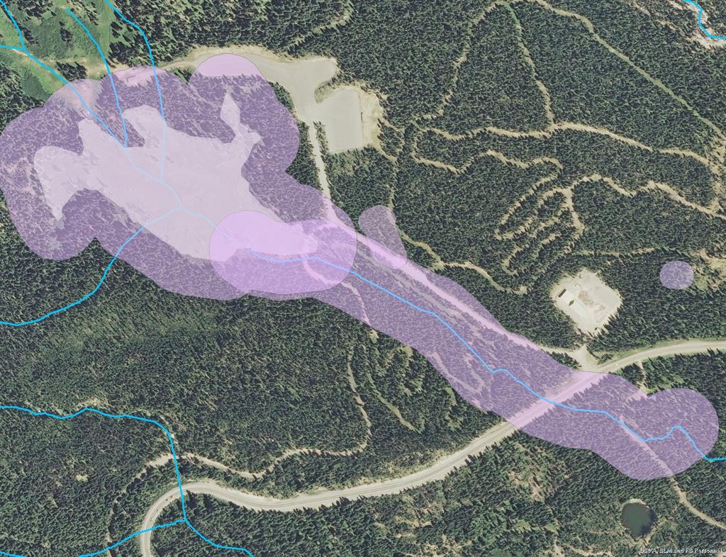
2 HRM Expansion Consideration 2 The entirety of proposed parking areas 1 and 2 are within the nest patch and disruption distance. Parts of 3 and 4 are also within the nest patch and disruption distance (see attached Map 3). When consultation for this project was completed, the Responsible Official made a conscious decision to remain outside the disruption distance, and not work inside the nest patch. Removing habitat within the nest patch is not consistent with either the Northern Spotted Owl Recovery Plan nor the Northwest Forest Plan. Other identified resource concerns in Parts 3 and 4 include the following: Parts 3 and 4 overlap with the Riparian Reserve for Meadows Creek (see attached Map 4). Part 3 overlaps with a small section of the Umbrella Falls hiking trail which would need to be re-located (see attached Map 2). Part 4 is immediately adjacent to a large wet meadow that is unique habitat for the Forest. The parking proposal would likely degrade this complex of wetlands. Also, this area likely is habitat for Survey and Manage and/or sensitive species. Part 4 is not ideal in such close proximity to the large meadow for big game thermal, calving/fawning habitat, and security habitat for our MIS species. Part 4 includes a high density of huckleberry plants, which are located on ceded lands and culturally significant to the Confederated Tribes of Warm Springs. Additional government-to-government consultation would be required. Part 4 includes the stormwater management system for the HRM parking lot (see attached Map 5). This would need to re-sized to accommodate additional parking or would need to be re-located. Part 5 of the proposal is adjacent to and includes the ODOT maintenance yard. The expansion of the ODOT maintenance yard was considered, but eliminated from detailed study. EIS section states: This alternative would utilize the ODOT maintenance yard as additional parking, rather than constructing the new Twilight Parking Lot. The maintenance yard could be expanded to allow for some additional parking and/or provide for storm water maintenance and snow storage. The ODOT maintenance yard would be relocated to a different location outside MHM Permit Area. One commenter suggested it move to the east side of Highway 35 further North, but still within a few miles of the current location in the center of the recreation zone. This alternative was formally proposed during the notice and comment period that was conducted in May The special use permit includes the operations and maintenance associated with a sandshed and two maintenance buildings to be used for winter sanding. The permit also
3 HRM Expansion Consideration 3 includes 0.1 mile of access road to the site from old Highway 35 (Forest Service Road 3545). The facility is closed to public access during the winter from November 1 through May 1 for public safety reasons. The use at this site was established in 1967 via special use permit. The original purpose of the permit was the construction of sand shed and maintenance of facilities needed to facilitate winter maintenance for Highway 35 and road to Hood River Meadows ski area. The purpose of the permit has not changed since its inception. The maintenance yard is approximately three acres located at T3S, R9E, Section 11. Two other special uses permit overlap with the ODOT maintenance yard. First, the Oregon Nordic Club has a special use permit administered by the Teacup Chapter for a storage shed located in the maintenance yard. Also, the Mt. Hood Meadows Ski Resort Permit Area overlaps with part of the maintenance yard. In order to implement this alternative, the use at this site as ODOT maintenance yard would need to be terminated. ODOT has made no indications that this site is no longer needed for winter operations. Similarly, the Oregon Nordic Club special use permit would need to be terminated at this site and they have made no indications that this site is no longer needed. Also, the MHM permit area boundary would have to be expanded to include the entire ODOT maintenance yard as well as the surrounding area needed for proper storm water management and snow removal associated with parking lots in order to implement this alternative. Terminating special use permits does not meet the purpose and need for action for this project. The primary purpose of this project is to serve the design capacity for parking, including area for snow storage, and maintenance facilities that was conceptually approved while minimizing environmental impacts from parking lot construction and maintenance, as was outlined in the Master Plan in 1997 (see Section 1-3). Also, relocating these uses to other areas of the Forest and/or expanding the MHM permit area to accommodate the parking lot is outside the geographic scope of the project. The geographic scope of the project includes the Mt. Hood Meadows Ski Resort permit area and access road to the permit area (see Section 1-3). As such this alternative is outside the scope of this project and was not considered in detail.
4
5 Legend Existing Umbrella Falls Trail Hrm_Parking_Lot_Drain_Field_ Miles Project Location Map - Twilight and Sunrise Improvements Mt. Hood Meadows Hood River Ranger District, Mt. Hood National Forest T3S, R9E, Sections 10 and 11
6 Hood River Meadows Parking Lot Highway 35 Legend Stream_LLID Consultation_action_area Chainsaw_65yds_disruption
7

8 Hood River Meadows Parking Lot Stormwater Management 2004 Monitoring Season HRM Parking Lot Concrete Ditch Sand Filter Meadows Creek
Mt. Hood Meadows 2013 Maintenance Projects Categorical Exclusion Checklist Mt. Hood National Forest May 14, 2012
 Mt. Hood Meadows 2013 Maintenance Projects Categorical Exclusion Checklist Mt. Hood National Forest May 14, 2012 Project Description Project Name: 2013 Mt. Hood Maintenance Projects Description of Project
Chapter 4 - Consultation and Coordination
 Chapter 4 - Consultation and Coordination Chapter 4-1 Mt. Hood Meadows Parking Improvements EIS Chapter 4-2 4.0. Consultation and Coordination Chapter 4 - Consultation and Coordination This chapter provides
DECISION MEMO OREGON DEPARTMENT OF TRANSPORTATION (ODOT) SAND SHED CINDER PIT EXPLORATION PROJECT
 SAND SHED CINDER PIT EXPLORATION PROJECT") DECISION MEMO OREGON DEPARTMENT OF TRANSPORTATION (ODOT) SAND SHED CINDER PIT EXPLORATION PROJECT USDA Forest Service Bend/Fort Rock Ranger District, Deschutes National Forest Deschutes County, Oregon
DECISION MEMO OREGON DEPARTMENT OF TRANSPORTATION (ODOT) SAND SHED CINDER PIT EXPLORATION PROJECT USDA Forest Service Bend/Fort Rock Ranger District, Deschutes National Forest Deschutes County, Oregon
DECISION MEMO Mt. Hood Meadows Ski Resort 2013 Maintenance Projects May 2013
 DECISION MEMO Mt. Hood Meadows Ski Resort 2013 Maintenance Projects May 2013 USDA Forest Service, Mt. Hood National Forest Hood River Ranger District Hood River County, Oregon In January 1997, the Forest
Juncrock Timber Sale Draft Environmental Impact Statement. Appendix G Soils
 Juncrock Timber Sale Draft Environmental Impact Statement Appendix G Soils Soil Condition Monitoring on the Barlow Ranger District of the Mt. Hood National Forest 1999 The Barlow Ranger District conducts
LAND USE ALLOCATIONS AND MANAGEMENT GOALS for POLALLIE-COOPER PLANNING AREA. Mt. Hood Land and Resource Management Plan (Forest Plan)
") LAND USE ALLOCATIONS AND MANAGEMENT GOALS for POLALLIE-COOPER PLANNING AREA Mt. Hood Land and Resource Management Plan (Forest Plan) Primary Land Use Allocations within Planning Area: B2-Scenic Viewshed
LAND USE ALLOCATIONS AND MANAGEMENT GOALS for POLALLIE-COOPER PLANNING AREA Mt. Hood Land and Resource Management Plan (Forest Plan) Primary Land Use Allocations within Planning Area: B2-Scenic Viewshed
Umpqua National Forest
 United States Department of Agriculture Forest Service Umpqua National Forest Tiller Ranger District 27812 Tiller Trail Highway Tiller, Oregon 97484 (541) 825-3100 Fax 825-3110 Dear Interested Citizen,
Wildlife Habitat Restoration and Improvements FY 2007 Project
 United States Department of Agriculture Forest Service Pacific Northwest Region Wildlife Habitat Restoration and Improvements FY 2007 Project Umpqua National Forest Diamond Lake Ranger District April 2008
ELK RAPIDS TOWNSHIP WATER QUALITY ACTION PLAN
 ELK RAPIDS TOWNSHIP WATER QUALITY ACTION PLAN Elk-River-Chain-of-Lakes Gaps Analysis Project The Watershed Center Grand Traverse Bay Tip of the Mitt Watershed Council Michigan Department of Natural Resources
DECISION NOTICE FINDING OF NO SIGNIFICANT IMPACT (FONSI)
") DECISION NOTICE AND FINDING OF NO SIGNIFICANT IMPACT (FONSI) FOR CASA LOMA RECREATION RESIDENCE PERMIT RENEWAL U.S. FOREST SERVICE CIBOLA NATIONAL FOREST SANDIA RANGER DISTRICT BERNALILLO COUNTY, NEW MEXICO
DECISION NOTICE AND FINDING OF NO SIGNIFICANT IMPACT (FONSI) FOR CASA LOMA RECREATION RESIDENCE PERMIT RENEWAL U.S. FOREST SERVICE CIBOLA NATIONAL FOREST SANDIA RANGER DISTRICT BERNALILLO COUNTY, NEW MEXICO
DECISION MEMO Robinhood Creek Helicopter Log Deck June, 2008
 DECISION MEMO Robinhood Creek Helicopter Log Deck June, 2008 USDA Forest Service, Mt. Hood National Forest Hood River Ranger District Hood River County, Oregon Flooding in the fall of 2006 caused significant
Decision Notice and Finding of No Significant Impact
 Decision Notice and Finding of No Significant Impact Gold Lake Bog Research Natural Area Boundary Adjustment and Nonsignificant Forest Plan Amendment #53 USDA Forest Service Middle Fork Ranger District,
TORCH LAKE TOWNSHIP WATER QUALITY ACTION PLAN
 TORCH LAKE TOWNSHIP WATER QUALITY ACTION PLAN Elk-River-Chain-of-Lakes Gaps Analysis Project The Watershed Center Grand Traverse Bay Tip of the Mitt Watershed Council Michigan Department of Natural Resources
DECISION NOTICE FOR THE. Fremont-Winema National Forests Motorized Travel Management Project AND. Fremont National Forest Plan Amendment 36 AND
 DECISION NOTICE FINDING OF NO SIGNIFICANT IMPACT, AND FINDING OF NON-SIGNIFICANT LAND AND RESOURCE MANAGEMENT PLAN AMENDMENTS FOR THE Fremont-Winema National Forests Motorized Travel Management Project
DECISION RECORD for the Rattlesnake Negotiated Timber Sale (Reference:
 DECISION RECORD for the Rattlesnake Negotiated Timber Sale (Reference: Bly Mtn. / Swan Lake / Rattlesnake Reservoir Forest Health and Woodland Treatments Environmental Assessment #OR014-99-6) Introduction
BIG ROCHE A CRI LAKE CHARACTERISTICS
 BIG ROCHE A CRI LAKE CHARACTERISTICS Lake Description Big Roche Cri Lake is located in north central Adams County and has a surface area of 205 acres, a shoreline length of 6.1 mile, a volume of 6,993
BANKS TOWNSHIP WATER QUALITY ACTION PLAN
 BANKS TOWNSHIP WATER QUALITY ACTION PLAN Elk-River-Chain-of-Lakes Gaps Analysis Project The Watershed Center Grand Traverse Bay Tip of the Mitt Watershed Council Michigan Department of Natural Resources
Proposed Action for Motorized Travel Management on the North Kaibab Ranger District
 United States Department of Agriculture Forest Service Proposed Action for Motorized Travel Management on the North Kaibab Ranger District Kaibab National Forest March 2010 The U.S. Department of Agriculture
Mount Shasta Nordic Center Special Use Authorization Re-issuance
 United States Department of Agriculture Forest Service Shasta-Trinity National Forest Headquarters 3644 Avtech Parkway Redding, CA 96002 (530) 226-2500 (530) 226-2490- TDD http://www.fs.usda.gov/stnf File
SHASTA-MCCLOUD MANAGEMENT UNIT OVER SNOW VEHICLE TRAIL GROOMING AND SNOWMOBILE FACILITY MAINTENANCE PROPOSAL
 DRAFT DECISION MEMO SHASTA-MCCLOUD MANAGEMENT UNIT OVER SNOW VEHICLE TRAIL GROOMING AND SNOWMOBILE FACILITY MAINTENANCE PROPOSAL U.S. FOREST SERVICE TOWNSHIP 40, 41, 42 AND 43 NORTH, RANGE 1, 2, 3 WEST,
Willamette National Forest McKenzie River Ranger District
 United States Department of Agriculture Forest Service Willamette National Forest McKenzie River Ranger District 57600 McKenzie HWY McKenzie Bridge, OR 97413 File Code: 1950 Date: October 8, 2008 To Interested
Recreation Report Kimball Hill Stands Management Gold Beach Ranger District, Rogue River-Siskiyou National Forest Date: April 27, 2016
 Kimball Hill Stands Management Gold Beach Ranger District, Rogue River-Siskiyou National Forest /s/ Date: April 27, 2016 Lorelei Haukness, Resource Specialist Rogue River-Siskiyou National Forest In accordance
Primer introduction to watershed management Plan Process highlight the major steps of plan development Project types look at some examples of common
 1 Primer introduction to watershed management Plan Process highlight the major steps of plan development Project types look at some examples of common projects Plan Organization how to read the plan Next
FINDING OF NO SIGNIFICANT IMPACT OWL CREEK GRAVEL PIT EXPANSION U.S. FOREST SERVICE
 FINDING OF NO SIGNIFICANT IMPACT OWL CREEK GRAVEL PIT EXPANSION U.S. FOREST SERVICE OURAY RANGER DISTRICT OURAY COUNTY, COLORADO BACKGROUND The Owl Creek Gravel Pit, also known as the Spruce Ridge Pit,
Acres within Planning Area. Total Acres Burned
 Calf-Copeland Project Description Figure 1: Dead sugar pine in the Calf-Copeland planning area. Sugar pine grow best in open conditions. In the absence of fire disturbance, high densities of Douglas-fir
Decision Memo Hungry Creek Watershed Road Maintenance and Stony Quarry Development Project
 Decision Memo Hungry Creek Watershed Road Maintenance and Stony Quarry Development Project USDA Forest Service Mount Hough and Beckwourth Ranger Districts Plumas County, CA Background We, (the USDA Forest
The Galton Project Kootenai National Forest. The Galton Project
 Introduction The Galton Project The Fortine Ranger District of the Kootenai National Forest is in the early stages of developing a project entitled Galton, named for the mountain range dominating the eastern
DECISION MEMO Knebal Springs Super Connector Trail Construction May 2013
 DECISION MEMO Knebal Springs Super Connector Trail Construction May 2013 USDA Forest Service, Mt. Hood National Forest Barlow Ranger District Wasco County, Oregon The Knebal Spring Trail System connects
CLEARWATER TOWNSHIP WATER QUALITY ACTION PLAN
 CLEARWATER TOWNSHIP WATER QUALITY ACTION PLAN Elk-River-Chain-of-Lakes Gaps Analysis Project The Watershed Center Grand Traverse Bay Michigan Department of Environmental Quality July 2011 Purpose The Grand
File Code: 1950 Date: March 22, 2011
 United States Department of Agriculture Forest Service Mt. Hood National Forest Barlow Ranger District 780 NE Court Street Dufur, OR 97021 541-467-2291 FAX 541-467-2271 File Code: 1950 Date: March 22,
Mill Creek Watershed Collaborative Working Group Participants. Mill Creek Watershed Collaborative Working Group Meeting Minutes August 26, 2010
 September 20, 2010 MEMORANDUM TO: FROM: SUBJECT: Mill Creek Watershed Collaborative Working Group Participants Mike Hernandez Mill Creek Watershed Collaborative Working Group Meeting Minutes August 26,
The Marsh Project: An Ecosystem Services Approach to NEPA Project Planning
 The Marsh Project: An Ecosystem Services Approach to NEPA Project Planning Photo Credit: Carina Rosterolla, Crescent RD US Forest Service, Deschutes NF, Crescent Ranger District Presenter: Tim Foley, Project
Boardman River Townships Project EAST BAY TOWNSHIP. WATER QUALITY ACTION PLAN Fall 2009
 Boardman River Townships Project EAST BAY TOWNSHIP WATER QUALITY ACTION PLAN Fall 2009 Partners: The Watershed Center Grand Traverse Bay Northwestern Michigan College - Great Lakes Water Studies Institute
Forestry Establishment and Wildlife Conservation Programs and Assistance
 The Upper Big Blue NRD Forestry Department: Forestry Establishment and Wildlife Conservation Programs and Assistance District Forestry Under the NRD s seedling sales program, tree and shrub stock is provided
Phase II: Proposed (regulated) Impervious in disturbed area (ac) Long Lake Existing Impervious in disturbed area (ac)
 Impervious in disturbed area (ac) Long Lake Existing Impervious in disturbed area (ac)") Permit Application No.: 17-181 Rules: Erosion Control, Wetland Protection, and Waterbody Crossings & Structures Applicant: Hennepin County Received: 4/27/17 Project: CSAH 112 Phase II Complete: 9/5/17
Permit Application No.: 17-181 Rules: Erosion Control, Wetland Protection, and Waterbody Crossings & Structures Applicant: Hennepin County Received: 4/27/17 Project: CSAH 112 Phase II Complete: 9/5/17
Appendix C. Consistency With Eastside Screens. Salvage Recovery Project
 Consistency With Eastside Screens Salvage Recovery Project APPENDIX C Consistency of Forest Vegetation Proposed Actions With Eastside Screens (Forest Plan amendment #11) CHANGES BETWEEN DRAFT EIS AND FINAL
STATE ENVIRONMENTAL POLICY ACT MITIGATED DETERMINATION OF NONSIGNIFICANCE
 n+ Skamania County Community Development Department Building/Fire Marshal Environmental Health Planning Skamania County Courthouse Annex Post Office Box 1009 Stevenson, Washington 98648 Phone: 509-427-3900
Decision Memo. Delta A Septic Repair (#33)
") Decision Memo Delta A Septic Repair (#33) USDA Forest Service Willamette National Forest McKenzie River Ranger District T16S, R5E, Section 16 Lane County, OR Proposed Action The McKenzie River Ranger District
Decision Memo Delta A Septic Repair (#33) USDA Forest Service Willamette National Forest McKenzie River Ranger District T16S, R5E, Section 16 Lane County, OR Proposed Action The McKenzie River Ranger District
CROSBY BROOK RESTORATION STUDY BRATTLEBORO, VT
 Key Stakeholders: CROSBY BROOK RESTORATION STUDY BRATTLEBORO, VT Funded By: VT Dept. of Environmental Conservation VT Agency of Transportation (VTrans) Town of Brattleboro NEWEA Spring Meeting Omni Mt.
Appendix J. Forest Plan Amendments. Salvage Recovery Project
 Forest Plan Amendments Salvage Recovery Project APPENDIX J Lynx and Old Growth Forest Plan Amendments CHANGES BETWEEN DRAFT EIS AND FINAL EIS Changes in Appendix J between the Draft and Final EIS include:
MILTON TOWNSHIP WATER QUALITY ACTION PLAN
 MILTON TOWNSHIP WATER QUALITY ACTION PLAN Elk-River-Chain-of-Lakes Gaps Analysis Project The Watershed Center Grand Traverse Bay Tip of the Mitt Watershed Council Michigan Department of Natural Resources
Forest Plan Amendment to Remove the Layng Creek Municipal Watershed Management Plan
 United States Department of Agriculture Forest Service Forest Plan Amendment to Remove the Layng Creek Municipal Watershed Management Plan Draft Decision Memo Umpqua National Forest Cottage Grove Ranger
ENVIRONMENTAL ASSESSMENT
 ENVIRONMENTAL ASSESSMENT, FINDING OF NO SIGNIFICANT IMPACT, and DECISION RECORD 1 ENVIRONMENTAL ASSESSMENT EA Number: OR-080-05-10 BLM Office: Marys Peak Resource Area, Salem District Office 1717 Fabry
2012 Flood Repair Projects
 2012 Flood Repair Projects Okanogan-Wenatchee National Forest Naches Ranger District 10237 U.S. Highway 12 Naches, WA 98937 (509) 653-1401 Cle Elum Ranger District 803 W. 2nd Street Cle Elum, WA 98922
FLORIDA ATLANTIC UNIVERSITY
 Supporting Data The purpose of the Element is to ensure the conservation, protection, and wise use of all natural ecosystems and natural resources on the University campus and in the context area. 1. Inventory
VILLAGE OF BELLAIRE WATER QUALITY ACTION PLAN
 VILLAGE OF BELLAIRE WATER QUALITY ACTION PLAN Elk-River-Chain-of-Lakes Gaps Analysis Project The Watershed Center Grand Traverse Bay Tip of the Mitt Watershed Council Michigan Department of Natural Resources
The Cool Soda Experience
 The Cool Soda Experience Karen Bennett Johan Hogervorst Anita Leach Nikola Smith The Sweet Home Community of Interest The Sweet Home Ranger District Interdisciplinary Team Regional NFS and Research staff
Final Decision Memo. Murphy Meadow Restoration Project. USDA Forest Service Willamette National Forest McKenzie River Ranger District
 Final Decision Memo Murphy Meadow Restoration Project USDA Forest Service Willamette National Forest McKenzie River Ranger District T19S, R5E, Sec. 23, 24. Lane County Oregon BACKGROUND The Murphy Meadow
Tenmile and Priest Pass Restoration Project Scoping Notice
 Introduction Tenmile and Priest Pass Restoration Project Scoping Notice USDA Forest Service Helena National Forest Helena Ranger District Lewis and Clark County, Montana The Helena Ranger District of the
Introduction. Background
 Introduction Snow Forest Day Use Recreation Area Project Mountaintop Ranger District, San Bernardino National Forest San Bernardino County, California October 9, 2009 The Mountaintop Ranger District, San
Southern Idaho National Forests:
 Southern Idaho National Forests: Boise National Forest: http://www.fs.fed.us/r4/boise/ 1249 S. Vinnell Way Boise, ID 83709 (208) 373-4100 The Boise National Forest has designated routes in two of the five
Ridgeline Energy SUP Anemometer Towers & SODAR Project Project Proposal & Public Scoping
 Ridgeline Energy SUP Anemometer Towers & SODAR Project Project Proposal & Public Scoping The Silver Lake and Paisley District Ranger of the Fremont-Winema National Forests is proposing to issue a special
PEACE RIVER MANASOTA REGIONAL WATER SUPPLY AUTHORITY Orange Hammock Ranch Conservation Fact Sheet
 PEACE RIVER MANASOTA REGIONAL WATER SUPPLY AUTHORITY Orange Hammock Ranch Conservation Fact Sheet Authority s Regional Water Supply Infrastructure The RV Griffin Reserve (RVG) property is owned by the
Appendix F. Contributions from Others
 Contributions from Others 1. Proposed Project (scoping) Comment Summary and Forest Service Responses Reference to the preliminary analysis (PA) is included in the response column, where applicable. Table
File Code: 1950 Date: November 17, 2015
 Logo Department Name Agency Organization Organization Address Information United States Forest Deschutes National Forest 63095 Deschutes Market Road Department of Service Bend/Fort Rock Ranger District
Forest Glen Recreation Residence Tract Septic Tank Replacement Proposed Action 05/04/2010
 Forest Glen Recreation Residence Tract Septic Tank Replacement Proposed Action 05/04/2010 Background The South Fork Management Unit of the Shasta-Trinity National Forest has one recreation residence tract
Hood River Watershed Group to sustain and improve the Hood River watershed through education, cooperation, and stewardship
 You are living in a watershed A watershed is the land area that drains to a particular lake, stream, or river. The Hood River watershed covers 339 square miles between Mt. Hood and the Columbia River.
Commercial Firewood Project. McCall and New Meadows Ranger Districts Payette National Forest
 1 Commercial Firewood Project McCall and New Meadows Ranger Districts Payette National Forest PROPOSED ACTION The proposal would harvest approximately 47 acres of trees in the Upper Elkhorn Creek drainage,
1792/5400 (OR-120) Umpqua River Sawyer Rapids EA OR Purdy Creek DM OR120-TS Dear Citizen:
 Umpqua River Sawyer Rapids EA OR Purdy Creek DM OR120-TS Dear Citizen:") United States Department of the Interior BUREAU OF LAND MANAGEMENT COOS BAY DISTRICT OFFICE 1300 AIRPORT LANE, NORTH BEND, OR 97459 Web Address: http://www.blm.gov/or/districts/coosbay E-mail: OR_CoosBay_Mail@
United States Department of the Interior BUREAU OF LAND MANAGEMENT COOS BAY DISTRICT OFFICE 1300 AIRPORT LANE, NORTH BEND, OR 97459 Web Address: http://www.blm.gov/or/districts/coosbay E-mail: OR_CoosBay_Mail@
Laguna Water System Improvement Environmental Assessment (EA)
") Laguna Water System Improvement Environmental Assessment (EA) USDA Forest Service San Diego County, California 1. Background The Mount Laguna water system presently serves over eight recreation sites,
Laguna Water System Improvement Environmental Assessment (EA) USDA Forest Service San Diego County, California 1. Background The Mount Laguna water system presently serves over eight recreation sites,
Why we re against the SHELLEY S FIELDS development plan
 Why we re against the SHELLEY S FIELDS development plan BACKGROUND In late 2004, developer Randy Shelley and a representative of the Hereford Zone Recreation Council unveiled a development plan known as
DECISION MEMO. Vipond Water Development
 Page 1 of 5 DECISION MEMO USDA Forest Service Wise River Ranger District Beaverhead County T2S, R10W, Sections 12, 13, 14, &18 Background This project is located in the Pioneer Landscape, East Face Management
Public Notice ISSUED: April 5, 2019 EXPIRES: May 6, 2019
 APPLICANT: Aitkin County Highway Department Public Notice ISSUED: April 5, 2019 EXPIRES: May 6, 2019 REFER TO: MVP-2019-00387-EJI SECTION: 404 - Clean Water Act 1. APPLICATION FOR PERMIT TO discharge fill
BLM Office: Lakeview District, Klamath Falls Resource Area Phone #:
 Decision Memorandum on Action and for Application of: Categorical Exclusion 516 DM2, Appendix 1, 1.12 Hazardous Fuel Reduction (PLAN CONFORMANCE AND CATEGORICAL EXCLUSION DETERMINATION) CX Log #: CX-04-17
POLICY FOR NATURAL RESOURCE MANAGEMENT AREAS
 POLICY FOR NATURAL RESOURCE MANAGEMENT AREAS I. POLICY STATEMENT Auburn University's (the University's) "Policy for Natural Resource Management Areas" implements the Campus Master Plan Land Use Element
SECTION 10: WETLANDS PROTECTION
 SECTION 10: WETLANDS PROTECTION 10-1 INTENT AND PURPOSE A. Intent 1. The City finds that wetlands serve a variety of beneficial functions. Wetlands maintain water quality, reduce flooding and erosion,
Draft Decision Memo OHV Trails 22 and 42 Reroute Project
 Draft Decision Memo OHV Trails 22 and 42 Reroute Project USDA Forest Service McKenzie River Ranger District Willamette National Forest Linn County, OR T13S, R7E, Sections 25 and 34 Willamette Meridian
RE: Request for public comments on a proposal to construct Cattle Watering Systems
 United States Department of Agriculture Forest Service Midewin National Tallgrass Prairie 30239 South State Route 53 Wilmington, IL 60481 (815) 423-6370.. File Code: 1950 Date: January 14, 2009 Dear Friends
DETAILED IMPACT ANALYSIS OF MARMOT BASIN LONG RANGE PLAN
 2.0 JURISDICTION Parks Canada s decisions about the acceptability of proposals presented in the LRP are guided by a number of regulatory instruments and policies, the most relevant of which are described
Collaborative Opportunities to Restore Wetland Functions in an Urbanized Setting: Moses Creek Restoration Case Study
 Collaborative Opportunities to Restore Wetland Functions in an Urbanized Setting: Moses Creek Restoration Case Study Presented to: SER 2013 World Conference Madison, WI 2013 Award Winner Presented by:
Santa Ana Hazardous Fuels Reduction Project Design Criteria
 Santa Ana Hazardous Fuels Reduction Project Design Criteria Front Country Ranger District, San Bernardino National Forest San Bernardino County, California September 16, 2010 DESIGN CRITERIA Various measures
Green Thunder Regeneration and Commercial Thinning Harvest FINDING OF NO SIGNIFICANT IMPACT (FONSI)
") U.S. Department of Interior Bureau of Land Management Roseburg District, Oregon Green Thunder Regeneration and Commercial Thinning Harvest FINDING OF NO SIGNIFICANT IMPACT (FONSI) The Swiftwater Field
U.S. Department of Interior Bureau of Land Management Roseburg District, Oregon Green Thunder Regeneration and Commercial Thinning Harvest FINDING OF NO SIGNIFICANT IMPACT (FONSI) The Swiftwater Field
WO AMENDMENT EFFECTIVE DATE: 10/21/2008 DURATION: This amendment is effective until superseded or removed.
 WO AMENDMENT 2409.19-2008-7 EFFECTIVE DATE: 10/21/2008 DURATION: This amendment is effective until superseded or removed. 2409.19_60 Page 1 of 3 FSH 2409.19 - RENEWABLE RESOURCES HANDBOOK CHAPTER 60 -
Resource Management Plans for Western Oregon
 Resource Management Plans for Western Oregon Bureau of Land Management Includes: Background, Timeline and NEPA Planning Steps, and the full text of the. The proposed action is to revise the current resource
Preliminary Decision Memo Recreation Residence Septic Repairs
 Preliminary Decision Memo 2014 Recreation Residence Septic Repairs USDA Forest Service McKenzie River Ranger District Willamette National Forest Lane County, Oregon T. 16 S., R. 5 E, Section 16 Willamette
Shasta-Trinity National Forest Shasta McCloud Management Unit. McCloud Ranger Station
 United States Department of Agriculture Forest Service Shasta-Trinity National Forest Shasta McCloud Management Unit McCloud Ranger Station P.O. Box 1620 McCloud, CA 96057 (530) 964-2184 (530) 964-2692
SCRCA SECTION 28 WETLAND POLICY
 April 21, 2016 SCRCA SECTION 28 WETLAND POLICY SCRCA Policies and Procedures of Administration of Section 28 Regulations Wetland Policies Definitions section (Source: Section 28 CA Act) Development means:
Dear Interested Party:
 United States Department of Agriculture Forest Service Beaverhead-Deerlodge National Forest 420 Barrett Street Dillon, MT 59725 406 683-3900 File Code: 1950 Date: June 7, 2011 Dear Interested Party: Thank
NEPA 101 AN INTRODUCTION TO THE NATIONAL ENVIRONMENTAL POLICY ACT FOR CITIZENS, USER GROUPS, NON-PROFITS, AND BUSINESSES. Naches Ranger District
 NEPA 101 AN INTRODUCTION TO THE NATIONAL ENVIRONMENTAL POLICY ACT FOR CITIZENS, USER GROUPS, NON-PROFITS, AND BUSINESSES 2012 Naches Ranger District Why Understand NEPA? Exercise your right as a citizen
OUTREACH NOTICE DETAIL/VACANCY
 OUTREACH NOTICE DETAIL/VACANCY Clackamas River Ranger District Mt. Hood National Forest R6- Pacific Northwest Region Administrative Support Assistant Outreach Notice Notice valid through 04/30/2018 The
PROJECT INFORMATION Moosalamoo National Recreation Area Campground Timber Management Project
 PROJECT INFORMATION Moosalamoo National Recreation Area Campground Timber Management Project The USDA Forest Service (USFS) is initiating an environmental analysis process for the proposed Moosalamoo National
Preliminary Decision Memo 2015 Recreation Residence Projects Odell Lake
 2015 Recreation Residence Projects Odell Lake USDA Forest Service Crescent Ranger District, Deschutes National Forest Klamath County, Oregon Background The Crescent Ranger District maintains 66 recreation
State of Florida Department of Community Affairs Areas of Critical State Concern Implementation Status Report Apalachicola Bay Area
 State of Florida Department of Community Affairs Areas of Critical State Concern Implementation Status Report Apalachicola Bay Area Thaddeus L. Cohen, AIA Secretary November 2006 CONTENTS Part 1 - Summary
OUTREACH NOTICE ABOUT THE JOB
 OUTREACH NOTICE Supervisory Forester / FSR Position (TMA) GS 0460 11 Council or New Meadows, ID The Payette National Forest is seeking candidates to fill one GS 0460 11 Supevisory Forester / FSR position
Public Information Centre No. 2 June 15, :00 8:00 pm. Valley Park Community Centre (GYM B) 970 Paramount Drive Stoney Creek
 970 Paramount Drive Stoney Creek") Public Information Centre No. 2 June 15, 2017 6:00 8:00 pm Valley Park Community Centre (GYM B) 970 Paramount Drive Stoney Creek Please complete the sign-in sheet and review display materials. The project
Public Information Centre No. 2 June 15, 2017 6:00 8:00 pm Valley Park Community Centre (GYM B) 970 Paramount Drive Stoney Creek Please complete the sign-in sheet and review display materials. The project
Meacham Creek Restoration Project
 Meacham Creek Restoration Project Meacham Creek Restoration Project Umatilla National Forest Walla Walla Ranger District Michael Rassbach, District Ranger Public Scoping Document Proposal Summary The Walla
CHAPTER 5. NPDES PHASE II EVALUATION
 CHAPTER 5. NPDES PHASE II EVALUATION A Stormwater Management Program for Medford was developed and submitted to the DEQ to meet requirements of the NPDES Phase II program. Phase II regulations require
Cass County Soil Erosion & Sedimentation Control Program
 Cass County Soil Erosion & Sedimentation Control Program Both residents and visitors of Cass County enjoy the beauty of over 250 lakes and ponds, along with numerous streams, creeks, and wetlands that
The Wyoming Wildlife Advocates also value the Caribou-Targhee National
 May 20, 2016 Jay Pence District Ranger USDA Forest Service Caribou-Targhee National Forest P.O. Box 777 Driggs, ID 83422 Re: Comments on the proposed Southern Valley Recreation Project, submitted to the
Environmental Assessment for Road Diobsud Road Repairs
 United States Department of Agriculture Forest Service Pacific Northwest Region Environmental Assessment for Road Diobsud Road Repairs Contents Chapter 1 purpose of and need for action... 3 Introduction...
Travel Management Final Rule Proposed Changes
 Travel Management Final Rule Proposed Changes 212.1 Definitions: Off-Highway Vehicle (OHV): Any motorized vehicle that drives on National Forest System Lands, including cars, trucks, motor homes, motorcycles
Sequoia National Forest, California; Summit Fuels Reduction and Forest Health. Notice of intent to prepare an environmental impact statement.
 This document is scheduled to be published in the Federal Register on 09/16/2015 and available online at http://federalregister.gov/a/2015-23236, and on FDsys.gov [3410-11-P] DEPARTMENT OF AGRICULTURE
Decision Notice and Finding of No Significant Impact
 Decision Notice and Finding of No Significant Impact Indigo and Middle Fork Willamette Enhancement Project USDA Forest Service Middle Fork Ranger District Willamette National Forest Lane County, Oregon
DECISION MEMO. West Fork Blacktail Deer Creek Hardened Crossing
 Page 1 of 6 Background DECISION MEMO USDA Forest Service Madison Ranger District Madison County T12S, R4W, Section 30 The project is in the Gravelly Landscape, Snowcrest Recommended Wilderness Management
Riparian Buffer Requirements. Department of Environmental Protection Bureau of Watershed Management
 102.14 - Riparian Buffer Requirements Department of Environmental Protection Bureau of Watershed Management 102.2 Scope and Purpose BMPs to protect, maintain, and restore water quality and existing designated
Storrie and Rich Fire Area Watershed Improvement and Forest Road 26N67 Re-alignment Project
 Notice of Proposed Action Opportunity to Provide Scoping Comments Storrie and Rich Fire Area Watershed Improvement and Forest Road 26N67 Re-alignment Project Mt. Hough Ranger District Plumas National Forest
Moonlight Aquatic Organism Passage Project
 Notice of Proposed Action Moonlight Aquatic Organism Passage Project Mt. Hough Ranger District Plumas National Forest Plumas County, California Figure 1. Hungry 1 aquatic organism passage outlet showing
FREQUENTLY ASKED QUESTIONS
 WETLAND INVENTORY AND PRIME WETLAND DESIGNATION FREQUENTLY ASKED QUESTIONS 1. Why was a Wetland Inventory conducted? The Master Plan adopted by the Town in 2005 mandated that the Grantham Conservation
Municipal Stormwater Management Plan Prepared For The Borough of Cape May Point By Van Note-Harvey Associates VNH File No.
 Municipal Stormwater Management Plan Prepared For The Borough of Cape May Point By Van Note-Harvey Associates 2005 VNH File No. 35317-210-21 Table of Contents Introduction... 3 Goals... 3 Storm water Discussion...
5. OTHER CEQA CONSIDERATIONS
 5. OTHER CEQA CONSIDERATIONS Cumulative Impacts CEQA requires the analysis of impacts due to cumulative development that would occur independent of, but during the same timeframe as, the project under