H IGHWAY 7 W IDENING :
|
|
|
- Rodney Ferguson
- 6 years ago
- Views:
Transcription

1 H IGHWAY 7 W IDENING : H I G H W A Y 290 O U A C H I T A R I V E R B R I D G E AHTD Job Environmental Assessment U.S. Department of Transportation Federal Highway Administration A PR I L Arkansas State Highway & Transportation Department
2
3 HWY OUACHITA RIVER BRIDGE F.A.P. Number STP-0026(27) Environmental Assessment Submitted pursuant to: The National Environmental Policy Act (NEPA) 42 U.S.C. 4322(2)(c) and 23 C.F.R. 771 Randal Looney Environmental Specialist Federal Highway Administration Submitted by: FEDERAL HIGHWAY ADMINISTRATION and ARKANSAS STATE HIGHWAY AND TRANSPORTATION DEPARTMENT Date of Approval U.S. Department of Transportation Federal Highway Administration The following people may be contacted for additional information concerning this document: Randal Looney FHWA 700 W. Capitol, Room 3130 Little Rock, AR (501) John Fleming AHTD P.O. Box 2261 Little Rock, AR (501) In compliance with the National Environmental Policy Act, this Environmental Assessment (EA) describes the plan to widen Highway 7 south of the City of Hot Springs, from Highway 290 to the Ouachita River bridge. The analysis did not identify any significant adverse environmental impacts, and identifies Alternative 1 as the Preferred Alternative. Comments should be directed to: Mail: Environmental - Public Involvement AHTD P.O. Box 2261 Little Rock, AR info@ahtd.ar.gov This EA is also available for review online at: Arkansas State Highway and Transportation Department

4 Title VI The Arkansas State Highway and Transportation Department (AHTD) ensures full compliance with Title VI of the Civil Rights Act of 1964 by prohibiting discrimination against any person on the basis of race, color, national origin or sex in the provision of benefits and services resulting from its federally assisted programs and activities. The AHTD public involvement process did not exclude any individuals due to income, race, color, religion, national origin, sex, age, or disability. For questions regarding the AHTD's Title VI Program, you may contact the Department s EEO/DBE Section Head (ADA/504/Title VI Coordinator) at (501) (Voice/TTY 711), or at the following address: EEO_DBE_Section_Head@ahtd.ar.gov. Americans with Disabilities Act (ADA) Information Materials can be provided in alternative formats: large print, Braille, or audiotape for people with disabilities by contacting AHTD s EEO/DBE Section Head (ADA/504/Title VI Coordinator) at (501) (Voice/TTY 711), or at the following address: EEO_DBE_Section_Head@ahtd.ar.gov. Persons who are deaf or hard of hearing may contact the AHTD through the Arkansas Relay Service at A federal agency may publish a notice in the Federal Register, pursuant to 23 USC 139(l), indicating that one or more federal agencies have taken final action on permits, licenses, or approvals for a transportation project. If such notice is published, claims seeking judicial review of those federal agency actions will be barred unless such claims are filed within 180 days after the date of publication of the notice, or within such shorter time period as is specified in the federal laws pursuant to which judicial review of the federal agency action is allowed. If no notice is published, then the periods of time that otherwise are provided by the federal laws governing such claims will apply.
5 Table of Contents i TABLE OF CONTENTS CHAPTERS Chapter 1 PURPOSE & NEED What is the Highway 7 widening project? What are the existing conditions on Highway 7? How is the project area changing? Why does Highway 7 need to be widened? What is the purpose of this project? What is the purpose of this Environmental Assessment? Who is leading this project?... 7 Chapter 2 ALTERNATIVE DEVELOPMENT What are the project limits and how were they chosen? What alternatives were evaluated in this EA? How has the public been involved? How have tribal governments been involved? Which of these alternatives will be considered? Chapter 3 PROJECT EFFECTS How would the project affect traffic and safety? How much would the proposed project cost? How would economic conditions in the Lake Hamilton community and surrounding areas be affected? How would the project affect properties in the area? How would the project affect cultural resources? Would noise levels change? Would utilities be affected? How would the project affect views? Would any hazardous materials be created or affected? How would water resources, such as streams, be affected? Would the project cause flooding in surrounding areas?... 18
6 ii Highway 7 Widening EA 3.12 Would any wetlands be impacted by the project? Would any protected species be impacted by the project? How would the project affect other natural resources? What are indirect and cumulative effects, and does the project have any? Chapter 4 RECOMMENDATIONS What are the results of this EA? Is the NEPA process finished? REFERENCE PAGES Acronyms APPENDICES Appendix A: Level of Service Descriptions Appendix B: Public Involvement Meeting Synopsis Appendix C: Conceptual Stage Relocation Study Appendix D: Cultural Resources Information Appendix E: Traffic Noise Report FIGURES 1 Hot Springs Area Average Daily Traffic Counts Project Area Alternative 1 Typical Cross Section TABLES 1 Average Daily Traffic Counts Alternative 1 Land Use Impacts Alternative Impact Comparison... 21
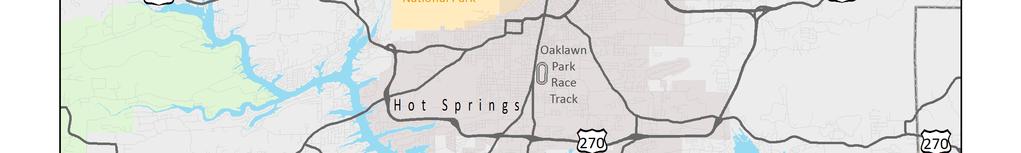
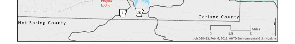
7 Purpose & Need 1 Chapter 1 Purpose & Need What s in Chapter 1? Chapter 1 explains the purpose of the project, why improvements to Highway 7 are needed, and who is leading the project. 1.1 What is the Highway 7 widening project? The Arkansas State Highway and Transportation Department (AHTD) is proposing to widen Highway 7 south of the City of Hot Springs, from Highway 290 north to the Ouachita River/Lake Hamilton. 1.2 What are the existing conditions on Highway 7? State of Arkansas Highway 7 begins at the Louisiana State Line near the City of El Dorado, and ends north of the City of Harrison near the Missouri State Line. It connects the southern coastal plain of Arkansas to the Ouachita Mountains, DeGray Lake Resort State Park, Hot Springs National Park, the Arkansas River Valley, the Ozark Mountains, and the Buffalo National River. As a State Scenic Byway, Highway 7 is utilized by travelers wishing to experience the scenic values of the byway and the features found along the route. Hot Springs Area In the Hot Springs area, Highway 7 provides access to Lake Hamilton (created by the damming of the Ouachita River), Oaklawn Park Race Track, Hot Springs National Park, the City of Fountain Lake, and the main entrance of Hot Springs Village. Highway 7 is one of only three highways that cross Lake Hamilton. Due to tourists accessing Lake Hamilton, Lake Ouachita, and the Ouachita River, as well as logging operations in both the Ouachita and Ozark-St. Francis National Forests, recreational vehicles and heavy trucks routinely utilize Highway 7. Highway 7 connections in the Hot Springs area can be seen in Figure 1. What does it mean when a highway is designated a State Scenic Byway? State Scenic Byways are highway corridors with unique scenic, geological, cultural, recreational, or other special characteristics. A State Scenic Byway designation means that the highway will be promoted for tourism and managed in a way that is compatible with the highway s unique qualities. The State Scenic Byway designation does not preclude any highway improvements, but does mean that visual intrusions such as off-premise advertising (e.g., billboards, signage, etc.) and salvage yards are restricted.


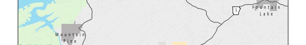
8 2 Highway 7 Widening EA Hot Springs Area Figure 1
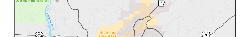
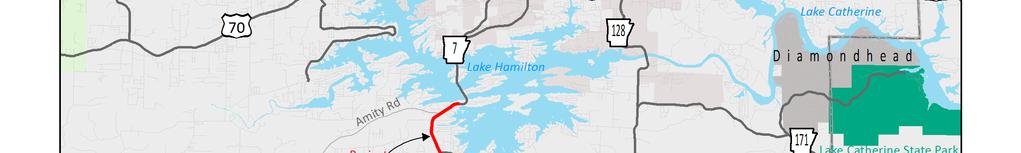
9 Purpose & Need 3 Project Area Highway 7 in the project area, from Highway 290 north to the Ouachita River/Lake Hamilton, is classified as a principal arterial and consists of two 11-foot wide travel lanes with 1-foot wide or 2-foot wide open shoulders, depending on the location. The posted speed limit is 45 mph. There are over 60 access points within the 1.67 mile section of Highway 7, primarily due to commercial driveways. Highway 7 in the project area can be seen in Figure 2. The traffic volumes on Highway 7 in the project area vary greatly because of heavy seasonal use by tourists going to the popular features and businesses along the highway. Table 1 and Figure 3 show the average daily traffic counts on Highway 7, south of the project area. What is a principal arterial? Urban principal arterials, such as Highway 7 in the project area, carry high volumes of traffic entering and leaving the urban area or connecting business districts and outlying residential areas. They also provide connections for rural arterials and connectors at the urban boundary. Table 1 Average Daily Traffic Counts Year Count Date Average Daily Traffic (vehicles per day) 2002 W ednesday, January 9 10,000* 2003 Monday, January 13 10,100* 2004 Monday, January 12 11,200* 2005 Monday, January 10 10,400* 2006 Tuesday, Sept em ber 12 7, Tuesday, October 2 7, Tuesday, Sept em ber 23 10,000 Average Daily Traffic Counts Vehicles Per Day 12, , 000 8,000 6,000 4,000 Peak 2002 Count* Off-peak 2006 Count 2009 Tuesday, Sept em ber 8 6,600 2, Monday, Septem ber 20 6, Monday, October 3 6, Monday, October 1 6,300 0 Figure Friday, Septem ber 16 6,000 *Count taken during Oaklawn racing season (peak)

10 4 H i gh wa y 7 W id en in g E A Project Area Figure 3
11 Purpose & Need 5 As seen in Table 1, traffic during peak travel months can include as many as 3,000 to 4,000 more vehicles per day than off-peak months on Highway 7 in and around the project area. Traffic is typically highest during the Oaklawn Park racing season (January through April) and during summer months when warm weather encourages vacationers and water sport enthusiasts to access the resorts, vacation homes, and access points on Lake Hamilton, Lake Ouachita, Lake Catherine, and the Ouachita River. Peak travel times during the day are also influenced by tourist and recreational traffic. Tourist and recreational traffic peaks occur within the project area near mid-day and past the typical evening peak traffic and rarely coincide with commuter and school traffic. Highway 290, at the southern end of the proposed project, is functionally classified as a major collector and provides access around the east side of Lake Hamilton through a connection to Highway 128 (Carpenter Dam Road). This is the only connection around Lake Hamilton east of Highway 7 in Garland County. Amity Road, which intersects Highway 7 near the midpoint of the proposed project at a signalized intersection, is also functionally classified as a major collector. 1.3 How is the project area changing? Although traffic volumes in the study area have grown only modestly in recent years (Table 1), there is a potential for traffic volumes to increase more rapidly in the future due to development. Garland County continues to grow, and while the City of Hot Springs is relatively land-locked, the Lake Hamilton area still has developable land in and around the project area. Because there are only two other routes that cross Lake Hamilton, there are few corridor options for future commercial development to expand south. The Hot Springs 2010 Comprehensive Plan includes the project area as a commercial development corridor. What is a major collector? Rural collectors, such as Amity Road and Highway 290 in the project area, generally serve travel within counties and of shorter distances than arterials such as Highway 7. Major collectors are distinguished from minor collectors by their links to business and industrial districts, major cities, such as the City of Hot Springs, or roads of higher classifications, such as Highway 7. The potential for future development along Highway 7 has also lead the proposed project to be included in the Tri-Lakes Metropolitan Planning Organization s (MPO) 2035 Long Range Transportation Plan and recommended by the MPO for inclusion in the Statewide Transportation Improvement Program.
12 6 Highway 7 Widening EA 1.4 Why does Highway 7 need to be widened? Traffic Flow In the United States, state highway agencies have categorized traffic flow with a qualitative measure called Level of Service (LOS). LOS is calculated for existing traffic volumes and forecasted in the future 20 years to ensure that state highway agencies are taking into account future growth. The LOS calculation results in one of six levels of service (A through F), described in Appendix A. Highway 7 from Highway 290 to Amity Road currently operates at LOS E during peak travel months and LOS D during off-peak months. If traffic growth continues, this section would operate at LOS E year-round by LOS E is considered unacceptable, as it is the point where traffic demand is approaching the capacity of the highway. LOS D is considered an acceptable LOS for urban areas. Highway 7 from Amity Road to the Ouachita River bridge has higher traffic volumes and currently operates at LOS E year-round. This section would continue to operate at LOS E over the 20-year study period. Safety Crash data from , the most recent years available, showed crash rates that were above the statewide average each year. The majority of the crashes were rear end collisions, with 50% of all crashes north of Amity Road and 67% of all crashes south of Amity Road consisting of rear end collisions. This type of collision occurs most frequently in urban settings with higher traffic volumes and traffic making left turns from the travel lanes (as opposed to a designated left turn lane), resulting in dangerous stop-and-go traffic movements. Bicyclists & Pedestrians In the project area, Highway 7 currently has no accommodations for bicycles or pedestrians, with shoulders that are less than three feet wide. Bicyclists are forced to use the single travel lane, while pedestrians use the narrow shoulder or walk off of the roadway. LOS can be calculated for bicycle traffic using factors affecting bicycle safety and travel. Bicyclists using Highway 7 in the project area currently experience LOS E over the entire study segment, which is considered unacceptable. The proposed project is consistent with the City of Hot Springs Master Plan recommendations for bike lanes around Lake Hamilton on Highway 7 and Highway 290. What does LOS take into account? The LOS calculator uses road and traffic conditions that affect traffic flow, such as: peak-hour traffic volume free-flow speed (how quickly free-flowing traffic would travel) shoulder and lane width percent of the daily traffic that consists of trucks, buses, or recreational vehicles passing opportunities number of traffic signals density of access points (intersections & driveways) terrain type of highway (commuter & long-distance routes with higher speeds or scenic & recreational routes with slower speeds) What are crash rates? Crash rates are based on the number of crashes per million vehicle miles traveled. For example, over the 3 year period, Highway 7 north of Amity Road had an average of 16.3 crashes per year, an average traffic volume of 15,800 vehicles per day, and is 0.74 mile long. This translated to a crash rate, per million vehicle miles, of These rates are compared to a statewide average crash rate, also per million vehicle miles, for similar highways. In this case, the statewide average crash rate for two-lane undivided urban highways, per million vehicle miles, was 2.8.
13 Purpose & Need What is the purpose of this project? The purpose of this project is to address the current and forecasted traffic flow issues as well as vehicle, bicycle, and pedestrian safety concerns. 1.6 What is the purpose of this Environmental Assessment? This Environmental Assessment (EA) is being prepared to: Evaluate the environmental effects of widening Highway 7. Inform and receive feedback from the public and decision makers about the environmental effects of the project. Determine whether effects are significant and require an Environmental Impact Statement or if the project effects can be sufficiently documented through an EA and Finding of No Significant Impacts (FONSI). 1.7 Who is leading this project? This project is being led by a partnership between the Federal Highway Administration (FHWA) and the Arkansas State Highway and Transportation Department (AHTD). The FHWA is involved because it is funding a portion of the project and has the primary responsibility for the content and accuracy of this National Environmental Policy Act (NEPA) document. What are significant impacts? NEPA regulations do not provide specific thresholds to determine if project impacts are considered significant, but they do discuss the process that should be used to evaluate impacts. Consideration is given both to context, where the significance of impacts varies with the setting of the proposed action, and intensity, the severity of the impacts. The project is also being funded through state funds allocated to the AHTD. The AHTD is responsible for administering and maintaining the state highway system, which includes Highway 7. For these reasons, the AHTD is a co-lead agency with the FHWA.
14 8 Highway 7 Widening EA Chapter 2 ALTERNATIVE DEVELOPMENT What s in Chapter 2? Chapter 2 identifies the project limits and briefly describes the alternatives evaluated in this EA. 2.1 What are the project limits and how were they chosen? The proposed project begins at Highway 290 and extends north to the Highway 7 bridge over the Ouachita River. The northern end of the project meets up with already widened portions of Highway 7, while Highway 290 at the southern end provides a logical end to the project. Highway 290 is a major collector providing a connection to Highway 128 (Carpenter Dam Road) around Lake Hamilton to the eastern side of the City of Hot Springs. Highway 290 to the Ouachita River bridge is also currently the extent of the more developed, urban section of Highway 7 south of the City of Hot Springs. South of Highway 290, Highway 7 takes on a much more rural aspect, and as such, would likely involve different design standards than the urban setting found throughout the proposed project area. 2.2 What alternatives were evaluated in this EA? Five alternatives were considered for this project: the No Action Alternative and four build alternatives. No Action Alternative The No Action Alternative would provide only routine maintenance for Highway 7 in the project area. By taking no action other than routine maintenance, the No Action Alternative would not address the current and forecasted traffic flow and safety concerns, which would increase as traffic volumes and commercial and residential development in the corridor increase. Why would you consider an alternative that does nothing? The National Environmental Policy Act (NEPA) requires decision makers to consider a no action alternative in all NEPA studies. This alternative usually does not meet the project s purpose and need, but is used to compare the beneficial and adverse impacts of action alternatives and determine their significance.
15 Alternative Development 9 Alternative 1 Alternative 1 would widen Highway 7 on the existing alignment to four travel lanes with a continuous, two-way, left turn lane and bicycle lanes and sidewalks on both sides of the highway. This alternative would improve Highway 7 in the project area to LOS C, which is acceptable, over the 20-year study period. The improved LOS and left turn lane should correct the stop-and-go traffic movements and reduce crash rates, particularly the rear end collisions which are prevalent in the project area. Alternative 2 Alternative 2 would widen Highway 7 on the existing alignment with the addition of a continuous, two-way, left turn lane and bicycle lanes and sidewalks on both sides of the highway, but would not add any travel lanes. With this alternative, Highway 7 would continue to operate at LOS E, which is unacceptable, between Amity Road and the Ouachita River bridge over the 20-year study period, although safety would be improved by removing left-turning vehicles from the travel lanes. The LOS between Highway 290 and Amity Road would likely improve to LOS D year-round, which is acceptable in urban areas, but would likely operate at LOS E again by 2035 during peak months. If additional development occurs along the corridor and traffic increases more than recent trends, by 2035 the LOS will likely drop to LOS E for off-peak months as well. Alternative 3 Alternative 3, a hybrid of the first two build alternatives, would widen Highway 7 on the existing alignment with the addition of a continuous, two-way, left turn lane and bicycle lanes and sidewalks on both sides of the highway. Two additional travel lanes would be added from Amity Road to the Ouachita River bridge, where traffic volumes are higher and the LOS is worse, but from Highway 290 to Amity Road would remain at only two total travel lanes. With Alternative 3, safety would be improved within the project area, along with the other enhancements. The LOS would remain acceptable from Amity Road to the Ouachita River bridge over the 20- year study period and would improve the LOS between Highway 290 and Amity Road during off-peak months, but by 2035, the LOS
16 10 Highway 7 Widening EA between Highway 290 and Amity Road would likely operate at LOS E during peak months. If additional development occurs along the corridor and traffic increases more than recent trends, by 2035 the LOS will likely drop to LOS E for off-peak months as well. Alternative 4 Alternative 4 would have the same mix of cross section as Alternative 3, but would have open shoulders south of Amity Road instead of bicycle lanes, sidewalks, and curb-and-gutter. This alternative provides a viable option for bicycles and pedestrians to be out of the travel lanes on a paved surface, while reducing the future cost of conversion of the segment to an urban cross section with curband-gutter, bicycle lanes, and sidewalks. Safety would be improved for vehicles with Alternative 4 with the addition of the continuous center left turn lane. Open shoulders can provide safe accommodations for bicycles and pedestrians; however, they may not have the same level of comfort as they would with bicycle lanes and sidewalks. Alternative 4 would have the same LOS as Alternative 3, with acceptable current and forecasted LOS north of Amity, but unacceptable forecasted peak LOS south of Amity. 2.3 How has the public been involved? A public involvement meeting was held on April 18, 2013, at the Lake Hamilton Baptist Church located at the intersection of Highway 7 and Highway 290. Two separate designs of Alternative 1 were shown to the public: one widening along the existing highway equally on both sides of the road, and the other shifting to one side or the other to avoid as many residential and commercial relocations as possible. The meeting was attended by 85 people, with 50 comment forms and one letter received. A majority (42) of the commenters indicated that they believed that Highway 7 needed to be widened in the project area, but many believed that their personal property would be adversely affected with either of the proposed designs of Alternative 1; however, 22 commenters preferred the minimization design while only seven preferred the design going down the middle of the existing alignment. As the design down the middle of the existing alignment would have likely resulted in as many as relocations, it was not considered a reasonable or prudent design, and the minimization alignment was retained for Alternative 1.
17 Alternative Development 11 As a result of the comments received about adverse property impacts, Alternatives 2, 3, and 4 were developed to examine the impacts and functionality of different project designs and footprints. The public involvement meeting synopsis can be found in Appendix B. 2.4 How have tribal governments been involved? Section 106 of the National Historic Preservation Act requires federal agencies to consult with tribes where projects could affect tribal areas with historical or cultural significance. The FHWA initiated coordination with the tribes with an active cultural interest in the area during the scoping process for this project. The tribes contacted included the Quapaw Tribe of Oklahoma and the Caddo Nation. The Tribal Historic Preservation Officers were given the opportunity to comment on the proposed project. No objections to the proposed project were received. 2.5 Which of these alternatives will be considered? All five alternatives considered in this chapter are feasible and able to be constructed. The No Action Alternative does not meet the project s purpose and need of improving current and forecasted traffic flow and correcting vehicle, bicycle, and pedestrian safety concerns; however, the No Action Alternative will be considered in this Environmental Assessment as a baseline comparison of impacts against the build alternative. What does it mean for an alternative to be feasible and prudent? NEPA defines feasible alternatives as those that can be built using current construction practices, while a prudent alternative is one that is reasonable, or makes sense. For example, alternatives that are not prudent may not meet the project s purpose and need, have severe operational or safety problems, unacceptable impacts, or cause severe community disruption. Although Alternatives 2, 3, and 4 improve safety with the addition of a center turn lane and with bicycle lanes and sidewalks (for Alternatives 2 and 3), they do not improve the forecasted LOS to acceptable levels for all or part of Highway 7 in the project area. Alternatives 2, 3, and 4 were dropped from further consideration as they do not meet the project s purpose and need and are therefore not considered prudent alternatives. They will not be discussed further in this EA. The minimization alignment and design developed for Alternative 1 meets the project s purpose and need while lowering the levels of impacts to the community; therefore, Alternative 1 will be the only build alternative considered in the remainder of this EA. Figure 4 shows the typical cross section of Alternative 1.
18 12 Highway 7 Widening EA Alternative 1 Typical Cross Section Figure 4
19 Project Effects 13 Chapter 3 PROJECT EFFECTS What s in Chapter 3? Chapter 3 identifies permanent and construction impacts that are expected as a result of the proposed project. Only elements that would be affected by the project are discussed. The impact areas discussed in Chapter 3 are summarized in Table 3, found at the end of the chapter. 3.1 How would the project affect traffic and safety? How would traffic patterns and volumes on Highway 7 and intersecting roads change with the project? Normal traffic patterns would not change with the construction of either Alternative 1 or the No Action Alternative. Widening Highway 7 with Alternative 1 may result in land use changes as development extends south, but forecasted traffic growth considers future growth in the project area. Crash rates would also be reduced with the additional travel lanes and continuous center left turn lane, lessening the likelihood of traffic disruptions due to collisions. The No Action Alternative would result in increasingly congested traffic flows and higher crash rates as traffic volumes increase over the 20-year study period, and the LOS would remain at unacceptable levels. How would the project affect safety? Alternative 1 would result in improved roadway safety with the additional travel lanes and a continuous, two-way left turn lane. Bicyclist and pedestrian safety will also be greatly improved with the addition of bicycle lanes and sidewalks on both sides of Highway 7. The No Action Alternative would not address any of the safety hazards or reduce the crash rates. Bicyclists and pedestrians would also have no improvements in safety, and actually encounter more dangerous conditions as traffic volumes increase on Highway 7 over the 20-year study period.
20 14 Highway 7 Widening EA How much traffic congestion would be caused by construction? While Highway 7 traffic would likely experience minor delays during the construction of Alternative 1, traffic would be maintained in both directions during construction. Because Alternative 1 involves constructing additional lanes on Highway 7, traffic can more easily be shifted to either side of the highway throughout construction. The No Action Alternative would not involve any highway construction. 3.2 How much would the proposed project cost? Using 2015 dollars, Alternative 1 is estimated to have $8 million in construction costs, $5.2 million in acquisition costs, $625,000 in business relocation costs, and $1.0 million in utility relocation costs. The total project cost is estimated to be $14.8 million. The No Action Alternative would not result in any construction and would only involve routine maintenance costs. 3.3 How would economic conditions in the Lake Hamilton community and surrounding areas be affected? Development along the route through the project area is primarily small businesses north of Amity Road, with a mix of residential and commercial south of Amity Road. Alternative 1 would require the relocation of 11 businesses, one non-profit organization, and three landlord businesses. The relocation of these businesses would negatively affect the local economy in the project area due to permanent and/or temporary loss of jobs and income, but would not negatively affect the overall economic conditions of the local community or the City of Hot Springs. A conceptual stage relocation study, found in Appendix C, determined that suitable locations could be found to relocate all 15 businesses. Alternative 1 would benefit the local economy by making the area more attractive to commercial development with safer, less congested travel and improved access for bicycles and pedestrians. What is a relocation? Relocations occur when a residence, business, or nonprofit is impacted severely enough by a proposed project that they cannot continue to live or do business at their current location. This is usually due to the proposed right of way limits requiring acquisition of a structure (house or business), taking most of a business s parking, or severing access to the property. The No Action Alternative would not have any direct negative impacts on local businesses or economic conditions, but would also not alleviate the existing and forecasted traffic flow and safety concerns, hindering the potential for development in the project area.
21 Project Effects How would the project affect properties in the area? Land cover in the immediate project area was historically mixed oakpine forest, but old-growth vegetation was removed through logging, then clearing for pasture, and finally for development. Lake Hamilton was created by the Arkansas Power and Light Company in 1932 when the Carpenter Dam was constructed on the Ouachita River to generate electricity. The 7,460 acre lake in close proximity to Hot Springs is one of Arkansas s most popular recreational and residential lakes, which has encouraged residential development along the lake and commercial development along the Highway 7 corridor. The land uses affected by Alternative 1 can be found in Table 2. Development is anticipated to occur through the proposed project corridor and surrounding areas, regardless of the implementation of this project, and would result in cumulative land use impacts outside of the direct land use conversions outlined above. Indirect impacts as a result of the proposed project include the additional utility right of way required for existing utilities that have to be relocated. Table 2 Alternative 1 Land Use Impacts Land Use Type Acres Com m ercial 3.4 W ooded 2.9 Pasture/Field 1.7 Residential 1.1 Vacant 0.5 Total 9.6 The No Action Alternative would not result in any right of way acquisition or relocations, and would not encourage any additional development in or around the project area. No indirect or cumulative impacts would be expected with the No Action Alternative Cost estimates, a conceptual stage relocation study, and an available housing inventory are provided in Appendix C. The right of way acreage and number of relocations identified in the conceptual stage relocation study for each alternative can be found in Table 3. Relocation assistance would be provided to all property and business owners relocated as a result of this project. Right of way acreages and relocation counts are based on the latest design plans, but are subject to change as a result of comments received at the Location and Design Public Hearing. 3.5 How would the project affect cultural resources? Section 106 of the National Historic Preservation Act requires agencies to consider the effects of Federal actions to historic properties. In compliance with Section 106 requirements, AHTD cultural resource specialists consult with the State Historic Preservation Officer (SHPO) and Native American tribes. What is a historic property? Cultural resources include elements of the built environment (buildings, structures, or objects) or evidence of past human activity (archeological sites). Those that are listed on or eligible for inclusion in the National Register of Historic Places (NRHP) are defined as historic properties.
22 16 Highway 7 Widening EA Preliminary checks with the Arkansas Archeological Survey and Arkansas Historic Preservation Program, as well as early maps of the project area, were checked for records of known archeological sites or historic structures. A cultural resources specialist also performed a survey of the project area to check for historic structures and completed an archeological survey of the areas that would be impacted by Alternative 1. From these records checks, field observations, and surveys, it has been determined that Alternative 1 and the No Action Alternative do not impact known historic properties and have a very low likelihood of impacting undiscovered cultural resources. Additional information about the cultural resources studies and SHPO clearance can be found in Appendix D. 3.6 Would noise levels change? Noise modeling indicates that a minor increase in noise levels will occur along the existing route from the projected traffic volume increase during the planning period. Three sensitive receptors will be impacted by noise for the No Action Alternative due to future traffic volume increases. Ten sensitive receptors will be impacted by noise for Alternative 1 due to the increase in traffic volumes and the design that brings the highway closer to some receptors. A noise barrier would be ineffective because of the gaps needed along the route for driveways and streets. Construction noise on Alternative 1 would be temporary and relatively minor. The traffic noise report detailing the methods used and the results of the noise study can be found in Appendix E. 3.7 Would utilities be affected? Impacts to utilities in the project area will be avoided and minimized as much as possible. Several utilities, including television, gas, electricity, sewer, telephone, and water, would need to be relocated to accommodate widening Highway 7 with Alternative 1, but significant impacts to area residents and business owners are not anticipated. Alternative 1 is estimated to have $1.02 million in utility relocation costs, which are included in the right of way cost estimates in Table 3. The No Action Alternative would not affect any utilities. What is noise? Sound is anything we hear, while noise is unwanted or undesirable sound. Traffic noise is a combination of the noises produced by vehicle engines, exhaust, and tires. What are sensitive noise receptors? Residences are considered sensitive noise receptors along with businesses that have a special sensitivity to noise, such as schools, churches, libraries, and parks.
23 Project Effects How would the project affect views? The viewshed from Highway 7 in the project area is largely residential and commercial development, tree-lined overhead utilities, and old fields. Trap Mountain is a positive visible resource for southbound traffic on a section of Highway 7 south of Amity Road. Lake Hamilton is a positive visible resource for travelers near the north end of the project, especially northbound traffic. The immediate project area does not currently contribute to the positive scenic aspect of Highway 7, although users of the road may be traveling the Highway 7 corridor to experience its scenic qualities. Construction of Alternative 1 would have no predictable impact on the viewshed other than unavoidable temporary negative visual impacts on the view of the highway during construction. 3.9 Would any hazardous materials be created or affected? A visual assessment and database search were performed to determine if any hazardous materials were located in the project area. Three underground storage tanks (USTs) were identified at an old fuel station in the southwestern corner of Highway 7 and Amity Road. Design plans indicate that the building and canopy would be impacted under Alternative 1. Because the pumps and fuel lines would be impacted, the USTs must be removed by an Arkansas Department of Environmental Quality (ADEQ) licensed contractor qualified for UST removal operations. What is a viewshed? A viewshed is simply the area that is visible from a specific location. The viewshed could be from the point of view from a vehicle, pedestrians, bicyclists, or even river users. What are hazardous materials? A hazardous material is any item or chemical that can cause harm to people, plants, or animals when released into the environment. The No Action Alternative would not impact any hazardous materials sites. Neither of the alternatives would involve the creation of hazardous materials. If hazardous materials are identified, observed or accidentally uncovered by any AHTD personnel, contracting company(s), or state regulating agency, it would be the AHTD s responsibility to determine the type, size and extent of contamination. The AHTD would identify the type of contaminant, develop a remediation plan and coordinate disposal methods to be employed for the particular type of contamination. All remediation work would be conducted in conformance with the ADEQ, Environmental Protection Agency (EPA), and Occupational Safety and Health Administration (OSHA) regulations.
24 18 Highway 7 Widening EA An asbestos survey by a certified asbestos inspector will be conducted on each building identified for demolition. If the survey detects the presence of any asbestos-containing materials, plans will be developed for the safe removal of these materials prior to demolition. All asbestos abatement work will be conducted in accordance with ADEQ, EPA, and OSHA asbestos abatement regulations How would water resources, such as streams, be affected? Two box culverts would have to be lengthened to accommodate the wider proposed cross section of Alternative 1, and would require the relocation of approximately 156 linear feet of an unnamed ephemeral stream. The results would be an impact to less than 0.1 acre of Waters of the United States. The construction of the proposed project should be allowed under the terms of a Nationwide Permit 14 for Linear Transportation Projects as defined in Federal Register 77(34) The AHTD will obtain all waterway and stormwater permits before construction begins. The No Action Alternative would not affect any water resources Would the project cause flooding in surrounding areas? The project was reviewed to identify any encroachments into special flood hazard areas, also known at the 100-year floodplain, as shown on the Flood Insurance Rate Maps issued by the Federal Emergency Management Agency. No areas of special flood hazard were identified within the project area. No direct, indirect, or cumulative impacts to floodplains are expected as a result of this project Would any wetlands be impacted by the project? There were no jurisdictional wetlands identified within the project area Would any protected species be impacted by the project? A records check of the Arkansas Natural Heritage Commission (ANHC) database of sensitive species indicated that no tracked species are known to occur within the project area. The ANHC tracks federally designated threatened or endangered species, as well as those that are considered sensitive species within Arkansas. What is an ephemeral stream? Ephemeral streams hold water only during and immediately after rain events. What is a floodplain? Floodplains are land areas that become covered by water in a flood event. 100-year floodplains are areas that would be covered by a flood event that has a 1% chance of occurring (or being exceeded) each year, also known as a 100-year flood. This is the floodplain commonly used for insurance and regulatory purposes. What is a wetland? Wetlands are areas typically inundated or saturated by surface or groundwater to the extent that they can support vegetation adapted for life in wet soil conditions.
25 Project Effects 19 Historic and current records have identified six federally listed freshwater mussel species and one listed species of aquatic plant from within the Ouachita River. All potential suitable habitat for these species in the project area was lost a result of the damming of the Ouachita River. All streams within the project area are tributaries to Lake Hamilton; therefore, any potential secondary and or cumulative effects related to increases in sedimentation and urban runoff will be diluted in Lake Hamilton and Lake Catherine How would the project affect other natural resources? The project is located within the Ouachita Mountains Ecoregion. The Ouachita Mountains are characterized by tilted, folded, and fractured layers of shale, sandstone, chert, and novaculite. The softer shales, cherts, and impure sandstones are more susceptible to erosion and have formed most of the basins, valleys floors, and lower hills, while the harder novaculites and pure sandstones form the mountains, ridges, and peaks. What is the difference between threatened and endangered species? An endangered species is one that is in danger of extinction throughout all or a significant portion of its range. Endangered species receive the highest level of protection. A threatened species is one that is likely to become endangered in the near future. threatened species. The landforms in the project area generally consist of rugged mountains with steeply sloping parallel ridges divided by narrow to wide valleys, although in the immediate project area, the Ouachita River basin is rolling to relatively flat. Soils in the project area consist of shallow to moderately deep, gently sloping to steep, well drained, gravelly soils Neither the No Action Alternative nor Alternative 1 would disturb any landforms or geological features, as the project area has been previously disturbed for logging, pasture, and the current commercial and residential developments What are indirect and cumulative effects, and does the project have any? Indirect Effects An indirect effect is a reasonably foreseeable effect that may be caused by a project but would occur in the future or outside of the project area. Widening Highway 7 could induce additional development south of the City of Hot Springs, but this area is currently experiencing growth which is likely to continue under either Alternative 1 or the No Action Alternative. The No Action Alternative involves no work other than regular maintenance and would not result in any indirect effects other
26 20 Highway 7 Widening EA than worsening traffic flow and safety concerns as traffic volumes increase over the 20-year planning period. Neither Alternative 1 nor the No Action Alternative are expected to result in adverse indirect impacts on any natural, cultural, social, or economic resources. Cumulative Effects Cumulative effects result from the total effects of a proposed project, when added to other past, present, and reasonably foreseeable future projects or actions. Cumulative effects are studied so that the public, decision-makers, and project proponents take time to consider the big picture effects a project could have on the community and environment. The AHTD does not have any other programmed jobs in the Lake Hamilton community that would impact businesses or result in additional impacts to the local economy. AHTD Job is programmed to improve Highway 7 from the Garland County Line to Highway 290. The density of commercial and residential development declines south of Highway 290. AHTD Job is also unlikely to contribute cumulatively to impacts on the local economy. No other reasonably foreseeable public or private projects are known to be in development in the project area. Neither Alternative 1 nor the No Action Alternative are expected to cumulatively contribute to any adverse impacts on any natural, cultural, social, or economic resources.
27 Recommendations 21 Chapter 4 Recommendations What s in Chapter 4? Chapter 4 contains the results and conclusions of this Environmental Assessment. 4.1 What are the results of this EA? The environmental analysis of the proposed project did not identify any significant impacts to the natural and social environment as a result of the No Action Alternative or Alternative 1. A summary of the impacts of these alternatives can be found in Table 3. Alternative 1, on the minimization alignment, has been identified as the Preferred Alternative, because it meets the project s purpose and need and minimizes impacts. Table 3 Alternative Impact Comparison Alternative Total Project Cost (2015 dollars) Construction Cost (2015 dollars) Right of Way Cost* (2015 dollars) Right of Way (acres) Relocations Noise Receptors Impacted Stream Impacts (linear feet) No Action Alternative m illion 8 m illion 6.8 m illion *Right of way cost includes right of way acquisition costs, business, non-profit, and landlord relocation costs, and utility relocation costs. 4.2 Is the NEPA process finished? After this EA is signed by the FHWA and approved for public dissemination, a Location and Design Public Hearing will be offered. After a review of comments received from citizens, public officials, and public agencies, a FONSI document will be prepared by the AHTD and submitted to the FHWA. Approval of the FONSI by the FHWA will identify the Selected Alternative and conclude the NEPA process.
28 22 Highway 7 Widening EA Reference Page Acronyms ADEQ AHTD ANHC EA EPA FHWA FONSI LOS MPO NEPA OSHA SHPO Arkansas Department of Environmental Quality Arkansas State Highway and Transportation Department Arkansas Natural Heritage Commission Environmental Assessment Environmental Protection Agency Federal Highway Administration Finding of No Significant Impacts Level of Service Metropolitan Planning Organization National Environmental Policy Act Occupational Safety and Health Administration State Historic Preservation Officer
29 Appendix A LEVEL OF SERVICE DESCRIPTIONS
30
31 Appendix A: LOS Descriptions A-1 Level of Service Descriptions Two-lane Highway (Vehicles) LOS A At LOS A, motorists experience high operating speeds and little difficulty in passing. A small amount of platooning would be expected. Drivers should be able to maintain operating speeds close or equal to the free-flow speed (FFS) of the facility. LOS B At LOS B, passing demand and passing capacity are balanced. Platooning becomes noticeable. It becomes difficult to maintain FFS operation, but the speed reduction is still relatively small. LOS C At LOS C, most vehicles are traveling in platoons. Speeds are noticeably reduced on all three classes of highway. LOS D At LOS D, platooning increases significantly. Passing demand is high but passing capacity approaches zero. A high percentage of vehicles are now traveling in platoons, and percent time-spent-following (PTSF) is quite noticeable. The fall-off from FFS is now significant. LOS E At LOS E, demand is approaching capacity. Passing is virtually impossible, and PTSF is more than 80%. Speeds are seriously reduced. Speed is less than two-thirds the FFS. The lower limit of this LOS represents capacity. LOS F LOS F exists whenever demand flow in one or both directions exceeds the capacity of the segment. Operating conditions are unstable, and heavy congestion exists on all two-lane highways.
32 A-2 Highway 7 Widening EA Two-lane Highway (Bicycle) Bicycle LOS is based on a bicycle LOS score model. The models uses variables determined from research that related to bicyclists comfort and perceived exposure while riding on highways, such as separation from traffic, motorized traffic volumes and speeds, heavy vehicle percentage, pavement quality, and on-highway parking. Higher vehicle volumes, a greater proportion of trucks and buses, and higher vehicle speeds all act to decrease a bicyclist s perceived comfort and traffic exposure. Striped bicycle lanes or roadway shoulders add to the perceived sense of traffic separation and improve the LOS. Pavement quality affects bicyclists ride comfort. The presence of on-highway parking negatively affects bicycle LOS because bicyclists tend to leave a buffer between themselves and parked vehicles, resulting in less separation between them and moving vehicles. The bicycle LOS score on two-lane highways in based, in order of importance, on the following five variables: Average effective width of the outside through lane Motorized vehicle volumes Motorized vehicle speeds Heavy vehicle (truck) volumes Pavement condition
33 Appendix B PUBLIC INVOLVEMENT MEETING SYNOPSIS
34
35 Appendix B: PI Meeting Synopsis B-1
36 B -2 H igh wa y 7 W id en i n g E A
37 Appendix B: PI Meeting Synopsis B-3
38 B-4 Highway 7 Widening EA
39 Appendix B: PI Meeting Synopsis B-5

40 B-6 Highway 7 Widening EA
41 Appendix C CONCEPTUAL STAGE RELOCATION STATEMENT
42
43 Appendix C: Conceptual Stage Relocation Statement C-1 General Statement of Relocation Procedure Persons displaced as a direct result of acquisition for the subject project will be eligible for relocation assistance in accordance with Public Law , and the Uniform Relocation Assistance Act of The Relocation Program provides advisory assistance and payments to minimize the adverse impact and hardship of displacement upon such persons. It is AHTD policy that adequate replacement housing will be made available, built if necessary, before any person is required to move from their residence. All replacement housing must be fair housing and offered to all affected persons regardless of race, color, religion, sex, or national origin. No lawful occupant shall be required to move without receiving a minimum of 90 days advance written notice. All displaced residential occupants are eligible for replacement housing payments and reimbursement of actual reasonable moving costs. Replacement housing payment are made to qualified owners and tenants, while moving expense payments are made to all who are required to move their property from the proposed right of way or from a property which is being acquired for a project. Businesses, farms, and nonprofit organizations are also eligible for reestablishment payments, not to exceed $10, Reestablishment payments are made in addition to Moving Expense payments. A business, farm, or nonprofit organization may be eligible for a fixed payment in lieu of the moving costs and reestablishment costs if relocation cannot be accomplished without a substantial loss of existing patronage. The fixed payment will be computed in accordance with the Code of Federal Regulations and cannot exceed $20, If the displacee is not satisfied with the amounts offered as relocation payments, they will be provided a form to assist in filing a formal appeal. A hearing will be arranged at a time and place convenient for the displacee and the case will be promptly and carefully reviewed. Relocation services will be provided until all persons are relocated or their relocation eligibility expires. The Relocation Office will have listings of available commercial properties. Information is also maintained concerning other Federal and State Programs offering assistance to displaced persons. Based on an on-site inspection and aerial photographs, it is estimated that the project could cause the following displacements and costs: Alternative 1 11 Businesses $250,000 1 Non-profit Organization $15,000 3 Landlord Businesses $30,000 5 Personal Property Owners $11,000 Services $55,080 Total $361,080
44 C-2 Highway 7 Widening EA The general characteristics of the displacees to be relocated are listed on the Conceptual Stage Inventory Record forms in the back of this report. The general characteristics have been determined by a visual inspection of the potential displacees by a Relocation Coordinator. The Relocation Coordinator utilizes past experiences and knowledge in making this determination. In the project area, 35 commercial properties are currently for sale and 30 commercial properties are for lease. A breakdown of the properties is as follows: Commercial Properties For Sale Number of Units Commercial Properties For Lease Number of Units $0 - $50,000 0 $50,001 - $100,000 4 $100,001 - $150,000 2 $150,001 - $200,000 5 $200,001 - $300,000 3 $300,001 - $500, $500,001 - $750,000 6 $750,001 - $2,000,000 3 Total sf* sf sf - 1,000 sf 4 1,001 sf - 2,000 sf 8 2,001 sf - 3,000 sf 7 3,001 sf - 5,000 sf 8 5,001 sf - 7,000 sf 1 7,001 sf - 10,000 sf 0 10,001 sf - 25,000 sf 1 Total 30 *sf = square feet The businesses and non-profit organization affected by the project may not be able to relocate in the immediate area of their displacement, resulting in termination of the operation; however, in order to assist the displaced businesses and non-profit organization in relocating, the AHTD will explore all possible sources of funding or other resources that may be available to the businesses and non-profit organization. Sources that will be considered include State and Local entities, the Department of Housing and Urban Development, the Economic Development Administration, the Small Business Administration, and other federal agencies. Emphasis will be given in providing relocation advisory services to the business. Appropriate measures will be taken to ensure that each entity displaced is fully aware of their benefits, entitlements, courses of action that are open to it, and any special provisions designed to encourage business and nonprofit organizations to relocate within the same community.
45 Appendix C: Conceptual Stage Relocation Statement C-3 Conceptual Stage Relocation Inventory Alternative 1 Type Relocation Number Large Family Households Disabled Person Households Minority Households Elderly Households Low Income Households Employees Affected (Range) Residential Owners Residential Tenants Businesses Partiallydisplaced Businesses Landlord Businesses Non-profit Organizations Personal Properties 5 Total
46 C-4 Highway 7 Widening EA
47 Appendix D CULTURAL RESOURCES INFORMATION
48
49 Appendix D: Cultural Resources Information D-1 Cultural Resources Information Cultural resources include elements of the built environment (buildings, structures, or objects) or evidence of past human activity (archeological sites). Those that are listed, or eligible for inclusion, in the National Register of Historic Places (NRHP) are defined as historic properties (36 CFR (l)). Impacts to historic properties are avoided, minimized, or mitigated through a variety of methods that vary depending on the nature of the property. Those that are not eligible for inclusion in the NRHP do not require protection. The cultural resources survey consisted of a review of appropriate records and a visual survey of the proposed alternatives by an AHTD staff archeologist. The survey was conducted in order to identify any obvious archeological sites or historic properties that might be affected by the project and to see if any of the alternatives were located within areas having a high probability for the occurrence of undiscovered cultural resources. In accordance with federal regulations (36 CFR 800.4a through 800.6) regarding the identification and treatment of historic properties, the Federal Highway Administration (FHWA) has initiated consultation regarding the project with the Quapaw Tribe of Oklahoma and the Caddo Nation. Consultation will remain open throughout the duration of the project. A variety of records were checked to determine if previously documented cultural resources were known in the project area. These include the archeological site files kept by the Arkansas Archeological Survey (AAS) in Fayetteville and the historic structure database kept by the Arkansas Historic Preservation Program (AHPP) in Little Rock. Several early maps were also reviewed to gather information regarding early historic settlement in the project area. The windshield survey consisted of driving to as many public access points as possible to determine if any unrecorded historic structures were present. A review of the AAS site files revealed no sites within the proposed alternatives. Site 3GA116 is located south of the project area. The site consisted of a lithic scatter and abandoned domestic structure. The construction of a trailer park in this location has destroyed the site. Several sites are recorded outside of the project area around Lake Hamilton. A review of the AHPP historic structure file shows no known historic structures within or near the project area. A Request for Technical Assistance was submitted to the State Historic Preservation Officer (SHPO) on existing structures that appeared to be at least 50 years old. Of the 13 structures submitted, SHPO found none eligible for inclusion in the NRHP. No new cultural resources were identified during the windshield survey. Several early maps were reviewed to gather information regarding early historic settlement in the project area. These included copies of the 1841 and 1845 General Land Office (GLO) maps for Township 3 South, Range 20 West and Township 4 South, Range 20 West, and the 1936 Garland County Highway Map. The 1841 GLO map showed no cultural indicators such as fields, houses, or
50 D-2 Highway 7 Widening EA roads. The 1845 GLO map showed a field in the far eastern part of Section 1, Township 4 South, Range 20 West. This field is now covered by Lake Hamilton. The 1936 Garland County Highway map showed Highway 7 in the same location. Several structures are shown along the highway. Alternative 1 was also plotted on the most recent Hot Springs South topographic quadrangle map in order to preview existing landforms for areas considered to have a high probability for Native American and historic settlements. An analysis of the Hot Springs South topographic quadrangle map shows that Alternative 1 crosses mainly hills and depressions. A Phase I archeological survey has already been conducted for the project and no new archeological sites were found. An AHTD Project Identification Form was submitted to the SHPO, and a no adverse effect finding by SHPO has been issued for this project, as seen on the following page. No cultural resources will be impacted by Alternative 1.
51 Appendix D: Cultural Resources Information D-3
52 D-4 Highway 7 Widening EA
53 Appendix E NOISE REPORT
54
55 Appendix E: Traffic Noise Report E-1 Traffic Noise Report Introduction This report documents the results of a noise analysis performed as part of the Environmental Assessment for AHTD Job The project is approximately 1.47 miles long and consists primarily of widening Highway 7 to four travel lanes with a center median and bike lanes. The primary purposes of the analysis were to identify any noise impacts created by the project and to evaluate the feasibility and reasonableness of providing noise abatement to mitigate those impacts. Noise Evaluation This study has been prepared in accordance with the FHWA noise standards, Procedures for Abatement of Highway Traffic and Construction Noise, 23 CFR 772 [1], and the Arkansas Highway and Transportation Department s Policy on Highway Traffic Noise Abatement [2] and includes the following tasks: Identification of noise sensitive land uses; Determination of future sound levels with and without the project; Determination of traffic noise impacts; Evaluation of noise abatement for areas determined to be impacted by the project; Discussion of construction noise; and, Information for local officials. Each of these analysis steps is discussed below following a discussion of AHTD s criteria for determining noise impacts. Traffic Noise Terminology Traffic noise levels are expressed in terms of the hourly, A-weighted equivalent sound level in decibels (dba). A sound level represents the level of the rapid air pressure fluctuations caused by sources such as traffic that are heard as noise. A decibel is a unit that relates the sound pressure of a noise to the faintest sound the young human ear can hear. The A-weighting refers to the amplification or attenuation of the different frequencies of the sound (subjectively, the pitch) to correspond to the way the human ear hears these frequencies. Generally, when the sound level exceeds the mid-60 dba range, outdoor conversation in normal tones at a distance of three feet becomes difficult. Figure 1 shows some typical indoor and outdoor sound levels.

56 E-2 Highway 7 Widening EA A 9-10 db increase in sound level is typically judged by the listener to be twice as loud as the original sound while a 9-10 db reduction is judged to be half as loud. Doubling the number of sources (i.e. vehicles) will increase the hourly equivalent sound level by approximately 3 db, which is usually the smallest change in hourly equivalent A-weighted traffic noise levels that people can detect without specifically listening for the change. Figure 1 Because most environmental noise fluctuates from moment to moment, it is standard practice to condense data into a single level called the equivalent sound level (Leq). The Leq is a steady sound level that would contain the same amount of sound energy as the actual time-varying sound evaluated over the same time-period. The Leq averages the louder and quieter moments, but gives much more weight to the louder moments in the averaging. For traffic noise assessment purposes, Leq is typically evaluated over the worst one-hour period and is defined as Leq (1h). The term insertion loss (IL) is generally used to describe the reduction in Leq (1h) at a location after a noise barrier is constructed. For example, if the Leq (1h) at a residence before a barrier is constructed is 75 dba and the Leq (1h) after a barrier constructed is 65 dba, then the insertion loss would be 10 db. Noise Abatement Criteria (NAC) Noise impacts are determined by comparing future project sound levels: (1) to a set of Noise Abatement Criteria (NAC) for a particular land use category, and (2) to existing sound levels. The FHWA noise standards (contained in 23 CFR 772) and AHTD s noise policy state that traffic noise impacts require consideration of abatement when worst-hour equivalent sound levels approach or exceed the NAC listed in Table 1. AHTD s noise policy defines approach as one decibel below the NAC. The FHWA noise standards and AHTD s noise policy also define impacts to occur if there is a substantial increase in design year equivalent sound levels above the existing equivalent sound levels. Substantial is defined by AHTD as an increase of 10 or more dba as shown in Table 2.
57 Appendix E: Traffic Noise Report E-3 Table 1 Noise Abatement Criteria Activity Category Activity Critieria 1 Leq dba Evaluation Location Activity Description A 57 Exterior Lands on which serenity and quiet are of extraordinary significance and serve an important public need where the preservation of those qualities is essential if the area is to continue to serve its intended purpose. B 2 67 Exterior Residential C 2 67 Exterior D 52 Interior E 2 72 Exterior F Active sport areas, amphitheaters, auditoriums, campgrounds, cemeteries, day care centers, hospitals, libraries, medical facilities, parks, picnic areas, places of worship, playgrounds, public meeting rooms, public or nonprofit institutional structures, radio stations, recording studios, recreation areas, Section 4(f) sites 4, schools, television studios, trails, and trail crossings. Auditoriums, day care centers, hospitals, libraries, medical facilities, places of worship, public meeting rooms, public or nonprofit institutional structures, radio studios, recording studios, schools, and television studios. Hotels, motels, offices, restaurants/bars, and other developed lands, properties or activities not included in A-D, or F. Agriculture, airports, bus yards, emergency services, industrial, logging, maintenance facilities, manufacturing, mining, rail yards, retail facilities, shipyards, utilities, (water resources, water treatment, electrical), and warehousing. G 3 Undeveloped lands that are not "permitted". 1. The Leq dba Activity Criteria values are for impact determination only, and are not design standards for noise abat ement. 2. Includes undeveloped lands that have been permitted for this Activity Category. 3. Indicates no building permits on or before the date of public knowledge. 4. Section 4(f) property means publicly owned land of a public park, recreation area, or wildlif e and waterf owl refuge of national, state, or local significance, or land of a historic site of national, state, or local significance, as initially defined in S ection 4(f) of the Depart ment of Transportation Act of 1966 and addressed in 23 CFR 774, Parks, Recreation Areas, Wildlife and Waterfowl Ref uges, and Historic Sites. Table 2 Noise Level Increase Categories Table 3 Noise Study Area Increase in Existing Noise Level (dba) Subjective Descriptor Description of Noise Study Area Activity Categories NAC (dba) 0-5 Minor 6-9 Moderate Residences, churches, restaurants, and hotels within 500 feet of the centerline of Highway 7 B, C, E and G 67 and or more Substantial
58 E-4 Highway 7 Widening EA Identification of Noise Sensitive Land Uses Review of available electronic mapping revealed one area with noise sensitive land uses that may be impacted by the proposed project. This area is called a noise study area and is described in Table 3. Noise impacts will be identified and noise abatement will be considered if design year sound levels at the Category B and C land uses are 66 dba or higher or if design year sound levels at the Category E land uses are 71 dba or higher. There are tracts of Activity Category G undeveloped lands in the project area. These undeveloped lands are not noise-sensitive and have not been included in the noise analysis; however, noise impacts could occur in the future if noise-sensitive land uses are constructed near Highway 7. A discussion of future sound levels and the need for noise compatible land use planning is provided later in this report. Determination of Existing Sound Levels Noise modeling of existing conditions was completed using the FHWA Traffic Noise Model (TNM 2.5) computer program, existing and proposed roadway cross sections, existing traffic data, and projected traffic data for the design year of The program calculated existing worst hour sound levels for the noise-sensitive land uses in the project area. Traffic data provided by AHTD were used for the noise analysis. These volumes indicate 15% total trucks on Highway 7. The existing posted speed of 45 mph was modeled. The locations of modeled receivers are shown in Figure 2. Three sensitive noise receptors are currently impacted. Determination of Future Sound Levels Sound levels for the No Action Alternative were modeled using the FHWA Traffic Noise Model (TNM 2.5) computer program. The program calculated design hour equivalent sound levels for the design years of 2014 and Design year 2034 traffic volumes on Highway 7 are predicted to be approximately 30% higher than existing volumes. As a result, existing sound levels were increased by 1 to 3 db at design year for the No Action Alternative and 1 to 6 db for Alternative 1. All modeled receivers in the No Action Alternative are shown in Figure 2.

59 Appendix E: Traffic Noise Report E-5
HIGHWAY 71 CORRIDOR IMPROVEMENT STUDY BELLA VISTA BYPASS MISSOURI STATE LINE BENTON COUNTY
 HIGHWAY 71 CORRIDOR IMPROVEMENT STUDY BELLA VISTA BYPASS MISSOURI STATE LINE BENTON COUNTY DRAFT December 2017 Highway 71 Corridor Improvement Study Bella Vista Bypass to Missouri State Line BENTON COUNTY
U.S. Department of Transportation Federal Highway Administration. Arkansas State Highway & Transportation Department
 AHTD Job 061390 CROOKED CREEK CHANNEL IMPROVEMENTS E n vironment al Assessm ent U.S. Department of Transportation Federal Highway Administration Arkansas State Highway & Transportation Department JUNE
4 COMMITMENTS 4.1 LAND USE AND LAND COVER
 4 COMMITMENTS Each Affected Environment and Environmental Consequences Subsection contains commitments specific to the impact area being assessed. This section contains a summary of the commitments that
5. Other Environmental Consequences
 5. Other Environmental Consequences 5.1 Unavoidable Adverse Impacts Impacts to the following environmental resources were evaluated for Alternative D, the preferred alternative, to determine if they would
Environmental Assessment
 United States Department of Agriculture Forest Service May 2009 Environmental Assessment Powder River Campground Decommissioning Powder River Ranger District, Bighorn National Forest Johnson and Washakie
Northwest State Route 138 Corridor Improvement Project
 Northwest State Route 138 Corridor Improvement Project Los Angeles County, CA DISTRICT 7- LA- 138 (PM 0.0/36.8); DISTRICT 7- LA- 05 (PM 79.5/83.1); DISTRICT 7- LA- 14 (PM 73.4/74.4) 265100/ 0700001816
WELCOME IL 47. Community Advisory Group Meeting #5 Waubonsee Community College Wednesday, May 31, 2017
 WELCOME IL 47 Community Advisory Group Meeting #5 Waubonsee Community College Wednesday, May 31, 2017 MEETING PURPOSE MEETING AGENDA 1. Welcome/Introduction 2. Review Previous Public Involvement 3. Process/Schedule
Downtown Estes Loop Project Frequently Asked Questions
 May 15 th, 2015 Project Status 1) Has Alternative 1 already been selected? Is it a done deal? Response: The NEPA process will proceed with environmental analysis of both the No Action and Alternative 1.
Chester Bridge Environmental Assessment (EA) CAG Meeting #2. October 12, 2017
 CAG Meeting #2. October 12, 2017") Chester Bridge Environmental Assessment (EA) CAG Meeting #2 October 12, 2017 Agenda Introductions Purpose & Need review and Merger Approval Review of the Conceptual Alternatives Recap of the Public Meeting
Chester Bridge Environmental Assessment (EA) CAG Meeting #2 October 12, 2017 Agenda Introductions Purpose & Need review and Merger Approval Review of the Conceptual Alternatives Recap of the Public Meeting
5.0 PRELIMINARY ENVIRONMENTAL REVIEW
 5.0 PRELIMINARY ENVIRONMENTAL REVIEW 5.1 INTRODUCTION A preliminary environmental review was performed on the proposed freeway improvements that form Concept C, which encompasses the three freeway corridors
Grottoes. Transportation Plan. Transportation Planning Division. Virginia Department of Transportation
 2020 Transportation Plan Developed by the Transportation Planning Division of the Virginia Department of Transportation in cooperation with the U.S. Department of Transportation, Federal Highway Administration
vi Figures viii Summary S.1
 Contents Contents iii Tables vi Figures viii Summary S.1 Chapter 1: Purpose and Need Project History A.1 Project Description A.2 Project Purpose A.5 Transportation Need A.6 Highway Capacity and Congestion
Transportation Facility Inventory
 CHAPTER 3 Transportation Element Section 3.1 Introduction Movement of people, goods, and services within and through the Town is an integral part of everyday life for the citizens of Hull. Decisions made
Final Air Quality Report
 Florida Department of Transportation - District VII County Line Road (C.R. 578) Project Development and Environment Study From U.S. 19 (S.R. 55) to U.S. 41 (S.R. 45) Work Program Item Segment Number: 257298
12 Evaluation of Alternatives
 12 Evaluation of Alternatives This chapter evaluates the effectiveness of the No-Build Alternative and the proposed METRO Blue Line Light Rail Transit (BLRT) Extension project based on the information
DIVISION I TRAFFIC IMPACT STUDY GUIDELINES ENGINEERING STANDARDS
 CITY OF ALBANY DEPARTMENT OF PUBLIC WORKS DIVISION I TRAFFIC IMPACT STUDY GUIDELINES ENGINEERING STANDARDS Prepared By PUBLIC WORKS DEPARTMENT ALBANY, OREGON 97321 Telephone: (541) 917-7676 TABLE OF CONTENTS
EXECUTIVE SUMMARY RIVER VALLEY INTERMODAL FACILITIES FINAL ENVIRONMENTAL IMPACT STATEMENT ES-1
 ES.1 INTRODUCTION This Final Environmental Impact Statement (FEIS) for the River Valley Intermodal Facilities (RVIF) in the Arkansas River Valley (ARV) has been written in accordance with the National
Welcome. Public Meeting. August 2, :00 to 7:00 p.m. Presentation 6:00 to 6:30 p.m.
 Welcome Public Meeting August 2, 2017 5:00 to 7:00 p.m. Presentation 6:00 to 6:30 p.m. www.glenwoodsouthbridge.net Welcome to the South Bridge Environmental Assessment Public Meeting Why Are We Here Tonight?
Chapter 5 Transportation Draft
 Chapter 5 Transportation Draft Discussion Similar to the other elements in the Comprehensive Plan, the transportation element impacts the quality of life, economic development and public safety of the
NOISE REPORT ADDENDUM July 2003
 Coalfields Expressway Section A Buchanan County, Virginia NOISE REPORT ADDENDUM July 2003 Current VDOT Project Number: 0121-013-101, PE101 Former VDOT Project Number: R000-961-101, PE101 Noise Study Addendum
DRAFT AIR QUALITY TECHNICAL MEMORANDUM
 AIR QUALITY TECHNICAL MEMORANDUM PROJECT DEVELOPMENT AND ENVIRONMENT STUDY STATE ROAD 60 GRADE SEPARATION OVER CSX RAILROAD Polk County, Florida Financial Project ID: 436559-1-22-01 Prepared for: Florida
M D 355 [FR E D E R IC K R O A D] OVER
![M D 355 [FR E D E R IC K R O A D] OVER](/thumbs/79/79553721.jpg "M D 355 [FR E D E R IC K R O A D] OVER") M D 355 [FR E D E R IC K R O A D] OVER LITTLE BENNETT CREEK MAINTENANCE OF TRAFFIC ALTERNATIVE ANA LYSIS Prepared by: INTRODUCTION The purpose of this report is to present the results of traffic analyses
M D 355 [FR E D E R IC K R O A D] OVER LITTLE BENNETT CREEK MAINTENANCE OF TRAFFIC ALTERNATIVE ANA LYSIS Prepared by: INTRODUCTION The purpose of this report is to present the results of traffic analyses
I-4 Beyond the Ultimate Project Development & Environment (PD&E) Reevaluation Study FROM WEST OF SR 528 (BEACHLINE EXPRESSWAY)
 Reevaluation Study FROM WEST OF SR 528 (BEACHLINE EXPRESSWAY)") I-4 Beyond the Ultimate Project Development & Environment (PD&E) Reevaluation Study FROM WEST OF SR 528 (BEACHLINE EXPRESSWAY) TO WEST OF SR 435 (KIRKMAN ROAD) ORANGE COUNTY, FLORIDA Financial Project
I-4 Beyond the Ultimate Project Development & Environment (PD&E) Reevaluation Study FROM WEST OF SR 528 (BEACHLINE EXPRESSWAY) TO WEST OF SR 435 (KIRKMAN ROAD) ORANGE COUNTY, FLORIDA Financial Project
Table Table 7.2 Potential Environmental Impacts and Mitigation Measures
 7.2 Natural Environment/Environmental Planning Executive Summary/Key Points The Environmental Consultation and Mitigation Plan establishes: o A process for consultation with environmental resource agencies
D R A F T. SECTION 4(f) EVALUATION. INTERSTATE 73 From I-95 to the Myrtle Beach Region
 EVALUATION. INTERSTATE 73 From I-95 to the Myrtle Beach Region") D R A F T SECTION 4(f) EVALUATION INTERSTATE 73 From I-95 to the Myrtle Beach Region INTRODUCTION Section 4(f) of the Department of Transportation Act of 1966, 49 USC 303 requires that prior to the use
D R A F T SECTION 4(f) EVALUATION INTERSTATE 73 From I-95 to the Myrtle Beach Region INTRODUCTION Section 4(f) of the Department of Transportation Act of 1966, 49 USC 303 requires that prior to the use
Project Prioritization for Urban and Rural Projects TEAM CONFERENCE March 7, 2018
 Project Prioritization for Urban and Rural Projects 2018 TEAM CONFERENCE March 7, 2018 Challenge Limited funding for transportation improvements requires strategic selection of projects to ensure resource
U.S. ARMY CORPS OF ENGINEERS BUILDING STRONG LOS ANGELES DISTRICT
 PUBLIC NOTICE U.S. ARMY CORPS OF ENGINEERS BUILDING STRONG LOS ANGELES DISTRICT APPLICATION FOR PERMIT Deer Valley Road, El Mirage Road to 109 th Avenue Public Notice/Application No.: SPL-2010-00884-AP
Project Information. Pursuant to Section 404 of the Clean Water Act (33 U.S. Code 1344), notice is hereby given that
, notice is hereby given that") US ARMY Corps Of Engineers Little Rock District JOINT PUBLIC NOTICE CORPS OF ENGINEERS STATE OF ARKANSAS Application Number: 2014-00083-1 Date: December 22, 2014 Comments Due: January 16, 2015 TO WHOM
US ARMY Corps Of Engineers Little Rock District JOINT PUBLIC NOTICE CORPS OF ENGINEERS STATE OF ARKANSAS Application Number: 2014-00083-1 Date: December 22, 2014 Comments Due: January 16, 2015 TO WHOM
CHAPTER 3 SCOPE SUMMARY
 CHAPTER 3 SCOPE SUMMARY GENERAL The SDDOT is an active member of AASHTO to share common national design standards for the state highway system. The AASHTO Task Force on Geometric Design has completed the
LOCATION HYDRAULIC REPORT
 Draft LOCATION HYDRAULIC REPORT Florida Department of Transportation District One US 41 at Fruitville Road (CR 780) Intersection Improvements - PD&E STUDY Sarasota County, Florida Financial Project ID
Environmental Impact Statement for the Green Line to the Airport Project. ACTION: Notice of Intent to Prepare an Environmental Impact Statement (EIS).
.") This document is scheduled to be published in the Federal Register on 11/18/2015 and available online at http://federalregister.gov/a/2015-29418, and on FDsys.gov DEPARTMENT OF TRANSPORTATION Federal Transit
This document is scheduled to be published in the Federal Register on 11/18/2015 and available online at http://federalregister.gov/a/2015-29418, and on FDsys.gov DEPARTMENT OF TRANSPORTATION Federal Transit
Chapter 10 Natural Environment
 Chapter 10 Natural Environment Existing Conditions The Natural Environment Element addresses the protection, conservation, preservation, and restoration of the natural resources the Bayview Ridge Subarea,
Project Initiation Form
 Meeting Date: The Project Initiation Form should be completed in conjunction with the Level 2 Screening Form. Process Leads and/or Planners should complete the Project Initiation Form to document coordination
PUBLIC NOTICE. Section 404 of the Clean Water Act (33 U.S.C. 1344) Section 10 of the Rivers and Harbors Act of 1899 (33 U.S.C.
 Section 10 of the Rivers and Harbors Act of 1899 (33 U.S.C.") US Army Corps Of Engineers Wilmington District PUBLIC NOTICE Issue Date: June 17, 2014 Comment Deadline: July 17, 2014 Corps Action ID#: SAW-2009-00655 NC DOT TIP: R-4903 The Wilmington District, Corps
US Army Corps Of Engineers Wilmington District PUBLIC NOTICE Issue Date: June 17, 2014 Comment Deadline: July 17, 2014 Corps Action ID#: SAW-2009-00655 NC DOT TIP: R-4903 The Wilmington District, Corps
PROCEDURES FOR NEW OR REVISED FREEWAY ACCESS IN ARKANSAS
 PROCEDURES FOR NEW OR REVISED FREEWAY ACCESS IN ARKANSAS June 2011 PROCEDURES FOR NEW OR REVISED FREEWAY ACCESS IN ARKANSAS June 2011 Prepared by: Arkansas State Highway and Transportation Department
CHAPTER 8 TRANSPORTATION ELEMENT
 CHAPTER 8 TRANSPORTATION ELEMENT Section 8.01 Purpose: The purpose of this Chapter (element) is to establish the desired and projected transportation system within Niceville and to plan for future motorized
Categorical Exclusion (CE)
") Categorical Exclusion (CE) Project Information Project Name: Federal Project#: Project Number: 0029-002-135, D624, P101 Project Type: Construction UPC: 77383 Charge Number: Route Number: 29 Route Type:
Categorical Exclusion (CE) Project Information Project Name: Federal Project#: Project Number: 0029-002-135, D624, P101 Project Type: Construction UPC: 77383 Charge Number: Route Number: 29 Route Type:
SUMMARY S.1 PROJECT DESCRIPTION AND LOCATION S.2 PURPOSE AND NEED
 S SUMMARY S.1 PROJECT DESCRIPTION AND LOCATION The Virginia Department of Transportation (VDOT), in cooperation with the Federal Highway Administration (FHWA), is studying alternatives to meet transportation
Chapter 5 - Transportation
 Chapter 5 - Transportation Discussion Similar to the other elements in the Comprehensive Plan, the transportation element impacts the quality of life, economic development and public safety of the residents
ARKANSAS DEPARTMENT OF TRANSPORTATION INTER OFFICE MEMORANDUM
 ARKANSAS DEPARTMENT OF TRANSPORTATION INTER OFFICE MEMORANDUM September 15, 2017 TO: Master Files FROM: John Fleming, Division Head, Environmental Division SUBJECT: Job Number 110643 FAP Number NHPP-0054(23)
State Route 8 Bridge Replacement Project
 OPEN HOUSE PUBLIC INVOLVEMENT MEETING Celebration Church 688 Dan Street, Akron, Ohio Tuesday, July 14, 2015 5:00 PM to 7:00 PM State Route 8 Bridge Replacement Project Existing Bridge Future Bridges: Steel
GUIDE FOR THE PREPARATION OF TRAFFIC IMPACT STUDIES
 GUIDE FOR THE PREPARATION OF TRAFFIC IMPACT STUDIES Adopted by Town Council on November 25, 2008 Prepared By: HNTB Engineering Department Planning Department TABLE OF CONTENTS I. INTRODUCTION... 1 II.
South Boston. Transportation Plan. Transportation Planning Division. Virginia Department of Transportation
 2020 Transportation Plan Developed by the Transportation Planning Division of the Virginia Department of Transportation in cooperation with the U.S. Department of Transportation, Federal Highway Administration
THE COMMONWEALTH OF MASSACHUSETTS NON-NHS BRIDGE R&R POLICY
 THE COMMONWEALTH OF MASSACHUSETTS Number: P-92-010 Date: 10-08-92 - ) HIGHWAY DEPARTMENT FROM: NON-NHS BRIDGE R&R POLICY The purpose of this Engineering Directive is to formally notify Department Personnel
ARKANSAS STATE HIGHWAY AND TRANSPORTATION DEPARTMENT
 ARKANSAS STATE HIGHWAY AND TRANSPORTATION DEPARTMENT Scott E. Bennett Director Telephone (501) 569-2000 Voice/TTY 711 P.O. Bo 2261 Little Rock, Arkansas 72203-2261 Telefa (501) 569-2400 www.arkansashighways.com
Categorical Exclusion Programmatic Agreement Between the Federal Highway Administration And the Indiana Department of Transportation
 Categorical Exclusion Programmatic Agreement Between the Federal Highway Administration And the Indiana Department of Transportation Introduction The Indiana Department of Transportation (INDOT) and the
4.11 TRAFFIC AND CIRCULATION
 4.11 4.11.1 ENVIRONMENTAL SETTING EXISTING TRAFFIC CONDITIONS Hyampom Road is the only all-weather access to the community of Hyampom, thereby making it the only school bus and mail route. It is also a
181 State Road 415, New Smyrna Beach. Railey Harding & Allen, P.A. Barcelo Developments, Inc. Scott Ashley, AICP, Planning Manager
 GROWTH AND RESOURCE MANAGEMENT DEPARTMENT PLANNING AND DEVELOPMENT SERVICES DIVISION CURRENT PLANNING ACTIVITY 123 W. Indiana Avenue, Room 202, DeLand, FL 32720 (386) 943-7059 PUBLIC HEARING: CASE NO:
Summary. Preliminary Alternative Development and Screening. DEIS July 23, 2018
 What is the Carolina Crossroads Project? The South Carolina Department of Transportation (SCDOT), in cooperation with the Federal Highway Administration (FHWA), is proposing to upgrade and redesign a key
An Overview and Comparison of the Tennessee Department of Transportation s Environmental Evaluation Process
 Introduction This document provides a brief overview of the policy and procedures that govern the environmental evaluation process that the Tennessee Department of Transportation (TDOT) must follow for
PROJECT INFORMATION Warren Falls Parking Lot Expansion Project
 PROJECT INFORMATION Warren Falls Parking Lot Expansion Project The USDA Forest Service (USFS) has initiated an environmental analysis process for the proposed Warren Falls Parking Lot Expansion Project
Introduction. Background
 Introduction Snow Forest Day Use Recreation Area Project Mountaintop Ranger District, San Bernardino National Forest San Bernardino County, California October 9, 2009 The Mountaintop Ranger District, San
Charlottesville Albemarle MPO:
 Charlottesville Albemarle MPO: Applying The Eco-Logical Approach To Small MPOs September 21, 2015 Charlottesville Albemarle Metropolitan Planning Organization (CAMPO) and The Thomas Jefferson Planning
FEDERAL HIGHWAY ADMINISTRATION RECORD OF DECISION FOR THE LYNNWOOD LINK EXTENSION
 FEDERAL HIGHWAY ADMINISTRATION RECORD OF DECISION FOR THE LYNNWOOD LINK EXTENSION AUGUST 2015 Table of Contents 1 Decision... 1 1.1 Project Description... 2 1.2 Basis for the FHWA Decision... 7 1.2.1
Section 7 Environmental Constraints
 Section 7 Environmental Constraints i Yakima Valley Metropolitan and Regional Transportation Plan Public Comment DRAFT 1/27/2016 Environmental Constraints Analysis A programmatic-level review of potential
DECISION MEMO Clay Butte Radio Repeater Relocation Project
 Background DECISION MEMO Clay Butte Radio Repeater Relocation Project USDA FOREST SERVICE Rocky Mountain Region (R2) Shoshone National Forest Park County, Wyoming The Shoshone National Forest, Clarks Fork
Indirect and Cumulative Effects
 Chapter 21: Indirect and Cumulative Effects 21-1 INTRODUCTION The federal Council on Environmental Quality s (CEQ) regulations implementing the procedural provisions of the National Environmental Policy
Warren Wagon Road Improvement Project McCall Ranger District, Payette National Forest Project Description
 Warren Wagon Road Improvement Project McCall Ranger District, Payette National Forest Project Description Introduction The analysis of the Warren Wagon Road Improvement Project is tiered to the 2003 Environmental
Oklahoma Department of Transportation Environmental Programs Division Office Fax
 Oklahoma Department of Transportation Environmental Programs Division Office 521-3050 Fax 522-5193 Documented Categorical Exclusion (DCE) for I-40: Pavement Reconstruction and Added Lanes from the Douglas
Supplemental Draft Environmental Impact Statement
 Supplemental Draft Environmental Impact Statement 40 67 Highway 67 - I-40 West Pulaski County, Arkansas January, 2007 Federal Highway Administration Arkansas State Highway and Transportation Department
Federal Highway Administration FINDING OF NO SIGNIFICANT IMPACT Interstate Highway 45 and Loop 197 Direct Connector Galveston County, Texas
 Federal Highway Administration FINDING OF NO SIGNIFICANT IMPACT Interstate Highway 45 and Loop 197 Direct Connector Galveston County, Texas Introduction The Federal Highway Administration (FHWA) has determined,
St. Francis Drive through the City of Santa Fe Corridor Study
 VIII. ENGINEERING AND ENVIRONMENTAL EVALUATION INTERSECTION IMPROVEMENTS SOUTHERN For the southern end of the corridor, traffic volumes are expected to increase over existing levels. The Phase A Report
Pole Creek Timber Salvage Project Specialist Report. Transportation. Introduction. Regulatory Framework / Management Direction
 Pole Creek Timber Salvage Project Specialist Report Transportation Donald Walker P.E. June 13, 2013 Introduction This report describes the effects to the transportation system from the Pole Creek Timber
Final Air Quality Report
 Florida Department of TRANSPORTATION Final Air Quality Report PD&E Study From East of Babcock Street (SR 507) to US 1 Brevard County, Florida Financial Project ID: 430136-1-22-01 ETDM Project Number: 13026
INFORMATION REQUIRED FOR PROBABLE CATEGORICAL EXCLUSION (SECTION (d))
)") Grant Applicant: Proposed Project: Date: August 03, 2010 Northern Virginia Transportation Commission, Arlington County Government, and Washington Metropolitan Area Transit Authority Crystal City/Potomac
Grant Applicant: Proposed Project: Date: August 03, 2010 Northern Virginia Transportation Commission, Arlington County Government, and Washington Metropolitan Area Transit Authority Crystal City/Potomac
Decision Memo Starkey Elk Handling Facility Water System Improvements
 Decision Memo Starkey Elk Handling Facility Water System Improvements USDA Forest Service Wallowa-Whitman National Forest La Grande Ranger District Union County, Oregon I. DECISION TO BE IMPLEMENTED A.
Lynnwood Link Extension 2013 Draft EIS Comments and Responses. Page 945
 I-441-001 Thank you for your comments about the importance of the Latvian Center to the Latvian community. Following the Draft EIS, the Sound Transit Board directed Sound Transit to develop a Preferred
2. Guiding Principles, Objectives, and Policies
 2. Guiding Principles, Objectives, and Policies INTRODUCTION The guiding principles for the 2040 MTP Update establish the vision and key focus areas for this planning effort. They combine the guidance
CHAPTER 5. City of Greensburg Comprehensive Plan. Introduction. Transportation Goals & Objectives
 CHAPTER 5 TRANSPORTATION Introduction The transportation system forms the backbone of the community. I-74 provides the community with connections to larger metropolitan areas such as Indianapolis and Cincinnati.
ARKANSAS STATE HIGHWAY AND TRANSPORTATION DEPARTMENT INTER OFFICE MEMORANDUM
 ARKANSAS STATE HIGHWAY AND TRANSPORTATION DEPARTMENT INTER OFFICE MEMORANDUM May 17, 2017 TO: Master Files FROM: John Fleming, Division Head, Environmental Division SUBJECT: AHTD Job Number 110620 FAP
MOSLEY STREET URBANIZATION TH
 Public Information Centre 1 (PIC 1) MOSLEY STREET URBANIZATION TH 45 BEACHWOOD ROAD TO STREET Class Environmental Assessment November 29, 2016 Welcome 2 This Public Information Centre will: establish channels
APPENDIX A. NEPA Assessment Checklist
 APPENDI A NEPA Assessment Checklist NEPA CHECKLIST DATE: January 12, 2009 PREPARER: Frederick Wells, RLA PIN and Project Title: Surplus Property Request Wilder Balter Partners Marketplace Town of Newburgh,
Welcome and thank you for spending time with us today to talk about the 75 th Street Corridor Improvement Project.
 1 Welcome and thank you for spending time with us today to talk about the 75 th Street Corridor Improvement Project. 2 During this public meeting, we will explain the 75 th Street Corridor Improvement
Trails Permitting Process
 Appendix H: Trail Permitting Process A PPENDIX H: T RAIL P ERMITTING P ROCESS Trails Permitting Process The permitting process is a critical component in the successful development of a trail network.
Transportation and Utilities
 4 Section 4 Transportation and Utilities 4.0 Introduction Transportation and utility systems are essential to accommodate and support development proposed in the Future Land Use Map. The following pages
Appendix D Functional Classification Criteria and Characteristics, and MnDOT Access Guidance
 Appendix D Functional Classification Criteria and Characteristics, and MnDOT Access Guidance Functional classification identifies the role a highway or street plays in the transportation system. Some highways
Woodlake General Plan Draft Environmental Impact Report
 5.0 UNAVOIDABLE ADVERSE ENVIRONMENTAL EFFECTS The following potential adverse environmental effects appear to be unavoidable if the Woodlake General Plan is implemented, even if certain mitigation measures
Welcome to the Public Information Centre. Red Hill Business Park South Transportation Master Plan Addendum. June 25, :00 p.m. to 8:00 p.m.
 Welcome Welcome to the Transportation Master Plan Addendum June 25, 2012 6:00 p.m. to 8:00 p.m. Please sign-in Background In 2006 the City of Hamilton completed the North Glanbrook Industrial Business
Chapter 2: Alternatives
 Chapter 2: Alternatives Introduction An Environmental Impact Statement (EIS) is a procedural document. In other words, the environmental planning process follows a logical sequence of development. Subsequent
RESOLUTION NO:
 RESOLUTION NO: 11-031 A RESOLUTION OF THE CITY COUNCIL OF THE CITY OF PASO ROBLES CERTIFYING THE FINAL ENVIRONMENTAL IMPACT REPORT FOR THE 2011 CIRCULATION ELEMENT OF THE GENERAL PLAN AND ADOPTING FINDINGS,
5. OTHER CEQA CONSIDERATIONS
 5. OTHER CEQA CONSIDERATIONS Cumulative Impacts CEQA requires the analysis of impacts due to cumulative development that would occur independent of, but during the same timeframe as, the project under
GEOMETRIC DESIGN CRITERIA for Non-freeway Resurfacing, Restoration, and Rehabilitation Projects
 GEOMETRIC DESIGN CRITERIA for Non-freeway Resurfacing, Restoration, and Rehabilitation Projects SEPTEMBER 1989 Arkansas State Highway and Transportation Department GEOMETRIC DESIGN CRITERIA for Non-freeway
TRANSPORTATION RELATIONSHIP TO OTHER ELEMENTS OF THE PLAN AND COUNTY REGULATIONS VISION FOR TRANSPORTATION PLANNING ROAD NETWORK SECTION 7
 TRANSPORTATION Like many growing western counties, Douglas County focuses on one of the most integral elements in land-use planning: transportation. The primary purpose of a transportation network is to
Washington Dulles International Airport EXECUTIVE SUMMARY
 EXECUTIVE SUMMARY The events of September 11, 2001 and the economic uncertainties facing commercial aviation have affected the timing of the Proposed Action. The Metropolitan Washington Airports Authority
CLA /10.54, PID Project Description:
 Project Description: The proposed project will consist of widening IR 70 to three lanes from Enon Road (SLM 06.75) to the US 68 interchange ramps (SLM 10.55). IR 70 is a component of the Strategic Highway
HIGHWAY 412 EXECUTIVEXECUTIVE SUMMARYUMMARY FINAL ENVIRONMENTAL IMPACT STATEMENT. Benton and Washington Counties. October 2005
 EXECUTIVEXECUTIVE SUMMARYUMMARY FINAL ENVIRONMENTAL IMPACT STATEMENT SPRINGDALE NORTHERN BYPASS HIGHWAY 412 Benton and Washington Counties October 2005 Federal Highway Administration Arkansas State Highway
Appendix D: Functional Classification Criteria and Characteristics, and MnDOT Access Guidance
 APPENDICES Appendix D: Functional Classification Criteria and Characteristics, and MnDOT Access Guidance D.1 Functional classification identifies the role a highway or street plays in the transportation
Appendix O Level of Service Standard and Measurements
 July 8, 2016 Appendix O. Appendix O Standard and Measurements Definition Level of service (LOS) is a mechanism used to determine how well a transportation facility is operating from a traveler s perspective.
Interstate 73 FEIS: I-95 to the Myrtle Beach Region Chapter 4. Public Involvement and Agency Coordination
 4-65 Interstate 73 FEIS: I-95 to the Myrtle Beach Region 4-66 Comment noted. The use of existing roadways was considered during alternative development (refer to Chapter 2, Section 2.1, page 2-1 and the
PROGRAMMATIC AGREEMENT
 PROGRAMMATIC AGREEMENT CATEGORICAL EXCLUSION APPROVALS NEW HAMPSHIRE DEPARTMENT OF TRANSPORTATION & FEDERAL HIGHWAY ADMINISTRATION FEBRUARY 2000 PREAMBLE This Agreement establishes the procedures of the
SECTION 5 Environmental Commitments
 0 0 0 SECTION Environmental Commitments During the design and implementation of the Preferred Alternative, MoDOT is committed to obtaining necessary permits and performing other actions that would minimize
Appendix O Congestion Management Program REGIONAL TRANSPORTATION PLAN/SUSTAINABLE COMMUNITIES STRATEGY
 Appendix O Congestion Management Program REGIONAL TRANSPORTATION PLAN/SUSTAINABLE COMMUNITIES STRATEGY 2014 REGIONAL CONGESTION MANAGEMENT PROGRAM 2014 RTP/SCS APPENDIX O SAN JOAQUIN COUNCIL OF GOVERNMENTS
COON CREEK WATERSHED DISTRICT PERMIT REVIEW. Spring Lake Park Schools Westwood Middle School st Avenue NE, Spring Lake Park, MN 55432
 PAN 16-112, Westwood Middle School, Page 1 of 6 COON CREEK WATERSHED DISTRICT PERMIT REVIEW MEETING DATE: August 22, 2016 AGENDA NUMBER: 10 FILE NUMBER: 16-112 ITEM: Westwood Middle School RECOMMENDATION:
DECISION MEMO OREGON DEPARTMENT OF TRANSPORTATION (ODOT) SAND SHED CINDER PIT EXPLORATION PROJECT
 SAND SHED CINDER PIT EXPLORATION PROJECT") DECISION MEMO OREGON DEPARTMENT OF TRANSPORTATION (ODOT) SAND SHED CINDER PIT EXPLORATION PROJECT USDA Forest Service Bend/Fort Rock Ranger District, Deschutes National Forest Deschutes County, Oregon
DECISION MEMO OREGON DEPARTMENT OF TRANSPORTATION (ODOT) SAND SHED CINDER PIT EXPLORATION PROJECT USDA Forest Service Bend/Fort Rock Ranger District, Deschutes National Forest Deschutes County, Oregon
11 Joint Development Regulatory Context and Methodology
 11 Joint Development This chapter describes the long-term direct and potential indirect impacts, and short-term direct and potential indirect impacts, of the proposed METRO Blue Line Light Rail Transit
Willmar Wye Public Open House #4 and Public Hearing
 Willmar Wye Public Open House #4 and Public Hearing February 23, 2017 www.dot.state.mn.us/d8/willmarwye Agenda Time Topic 5:00 pm Open House Opportunity for the public to ask questions of project staff
Preliminary Drainage Study: Town of Hillsboro Pedestrian & Traffic Safety Project Traffic Calming Project UPC# 70587
 Preliminary Drainage Study: Town of Hillsboro Pedestrian & Traffic Safety Project Traffic Calming Project UPC# 70587 Introduction: The intent of this study was to perform a preliminary drainage study of
Lubbock Outer Route Feasibility Study Report Executive Summary
 Lubbock Outer Route Feasibility Study Report Executive Summary Prepared for: Texas Department of Transportation Lubbock District Prepared by: MACTEC Engineering and Consulting, Inc. 6701 Aberdeen, Suite
Public Meeting. US Highways 18 & 281 and SD Highway 50 From Douglas County Line to SD46 Charles Mix County
 Public Meeting US Highways 18 & 281 and SD Highway 50 From Douglas County Line to SD46 Charles Mix County Cary Cleland Road Design Engineering Supervisor January 17, 2017 Project Limits US18/US281 US281
Proposed Action: In response to resource specialist concerns raised during internal scoping, the following restrictions will apply:
 DECISION MEMO USDA Forest Service Inyan Kara Riders Motorcycle Enduro Event Rocky Mountain Region Thunder Basin National Grassland Medicine Bow-Routt National Forests Douglas Ranger District April 2011