HEC-RAS 2D Modeling in Support of Ascension Parish Levee Certification
|
|
|
- Kelly Harmon
- 6 years ago
- Views:
Transcription

1 HEC-RAS 2D Modeling in Support of Ascension Parish Levee Certification OFMA 2017 Annual Conference September 19, 2017 Presented by: Jeff Doudrick, PE, ENV SP Project Manager HNTB Corporation
2 Agenda Project Description and Objectives Path to LAMP Benefit Determination Modeling Approach August 2016 Flood Calibration and Results Path Forward Discussion 2

3 3 Project Location

4 4 Study Area Focus
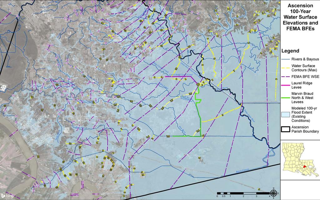
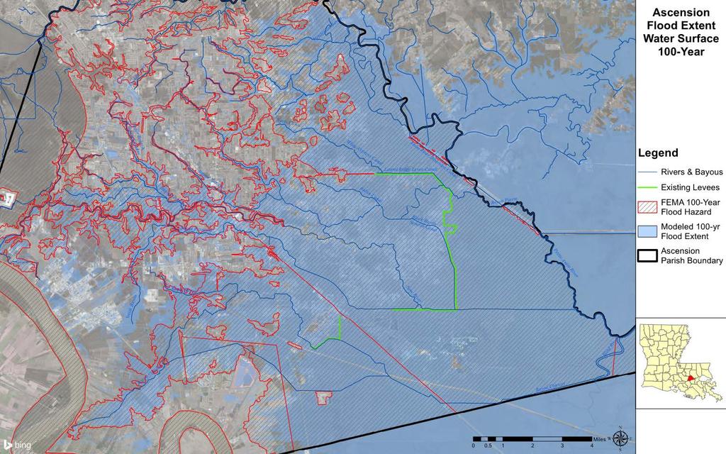
5 Project Objectives Evaluate steps to certify and accredit the existing levee system associated with the Marvin Braud Pump Station Marvin Braud North Marvin Braud West Laurel Ridge Reduce flood risk Reduce flood insurance rates Improve Community Rating System (CRS) rating 5

6 6 FEMA LAMP
7 Collaboration Continuous, collaborative communication with key stakeholders 7 Meetings & Technical Work-Shops with FEMA Region VI, FEMA LOMR, DOTD, and Parish Formal and informal meetings/communications with USACE and CPRA Peer-review available reports and studies Not re-inventing the wheel Incorporated available relevant data & information 7
 Levee & Pump Station Inspection Levee & Channel Surveys Geotechnical Field Data Collection &")
8 Path to LAMP Determination Interior influenced by Exterior Recommended 2D Model Recommended Coincident Event Analysis 471,640 = 89.3 miles of survey completed Program Implementation Plan H&H Modeling, FEMA LAMP ( Sensitivity Analyses ) Levee & Pump Station Inspection Levee & Channel Surveys Geotechnical Field Data Collection & Analyses Hydrologic & Hydraulic Modeling Data Collection & Develop Plan Recommended LAMP Overall rating of the Marvin Braud Levee System - Unacceptable MB Pump Station Requires updated O&M Manual & updated Operations Procedures Five 80-ft soil borings 8

9 9 Hydrologic & Hydraulic Modeling- Approach
 Decided on")
10 Model Formulation: HEC-RAS v5.0 with 2-D Interior Drainage System Modeling Started with current effective FEMA hydraulic model (1-D) Decided on HEC-RAS 2-D to better represent the interconnected flow of the bayous and canals 10
 Backwater impact at Highway 22 Expanded 1-D Modeling to include reach")
11 Model Formulation: HEC-RAS v5.0 with 2-D Exterior River Modeling Started with update of current effective FEMA hydraulic model (1-D) Backwater impact at Highway 22 Expanded 1-D Modeling to include reach from Diversion to Maurepas 1-D Modeling produced artificially high WSEL at downstream end Decided on full 2-D model for exterior and interior 11
 to provide the best representation of overflow from the Amite River into the interior of the levee system AMITE RIVER")
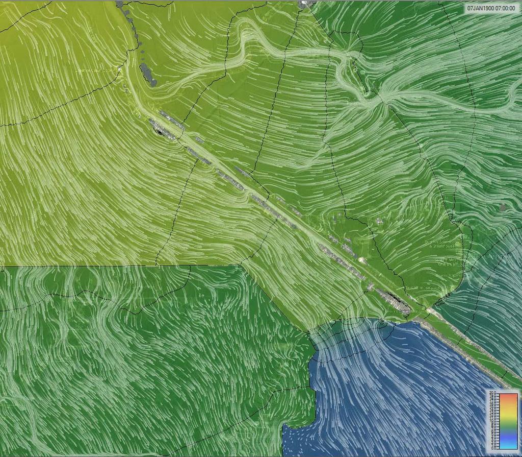
12 Initial Model Development Combined Interior-Exterior Model (~ 400 sq. miles) to provide the best representation of overflow from the Amite River into the interior of the levee system AMITE RIVER SPANISH LAKE INTERIOR LAKE MAUREPAS EXTERIOR MB PUMP STATION 12

13 Initial Model Development, 2D Grid SPANISH LAKE 13

14 Initial Model Development, Surface SPANISH LAKE 14

15 Initial Model Development, Roughness SPANISH LAKE 15


16 16 August 2016 Historic Flood

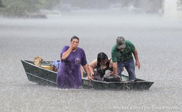
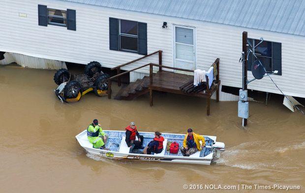
17 August 2016 Historic Flood Largest flood of record Somewhere between a 100yr and 500yr event Nearly 1/3 of homes within Ascension Parish flooded Happened in the middle of building our model Lots of data collected for model calibration 17
18 18 August 2016 Historic Flood

19 2-D Model Calibration: Aug 2016 Event PORT VINCENT SPANISH LAKE INTERIOR LAKE MAUREPAS EXTERIOR 19
20 2-D Model Calibration: Aug 2016 Event 18.0 RAINFALL 18.0 PORT VINCENT Cumulative Rainfall Depth (in) /6 8/8 8/10 8/12 8/14 8/16 8/18 8/20 8/22 8/24 Cumulative Rainfall (in) RAINFALL RAINFALL RUNOFF Cumulative Rainfall Runoff (in) (SERC SCS CN Method) Stage (ft) AMITE /11 8/13 8/15 8/17 8/19 8/21 8/23 8/25 USGS Stream Gage LAKE MAUREPAS 8.0 MB PUMP STATION Stage (ft) BLIND RIVER AMITE Stage (ft) EXTERIOR INTERIOR /11 8/13 8/15 8/17 8/19 8/21 8/23 8/25 USGS Stream Gage USGS Stream Gage /11 8/13 8/15 8/17 8/19 8/21 8/23 8/ USGS Stream Gage , DS USGS Stream Gage , US 20
21 2-D Model Calibration: Aug 2016 Event 10.0 BLACK BAYOU DS 12.0 BLACK BAYOU US GAGE MODEL 10.0 GAGE Stage (ft) Stage (ft) 6.0 MODEL /11 8/13 8/15 8/17 8/19 8/21 8/23 8/25 USGS Stream Gage HEC-RAS WSE 0.0 8/11 8/13 8/15 8/17 8/19 8/21 8/23 8/25 USGS Stream Gage HEC-RAS WSE 14.0 GRAND GOUDINE 9.0 BAYOU FRANCOIS Stage (ft) MODEL GAGE Stage (ft) MODEL GAGE /11 8/13 8/15 8/17 8/19 8/21 8/23 8/ /11 8/13 8/15 8/17 8/19 8/21 8/23 8/25 USGS Stream Gage HEC-RAS WSE USGS Stream Gage HEC-RAS WSE 21

22 22 2-D Model Calibration: Aug 2016 Event
23 Coincident Event Analysis Questions: What is the 100-year interior event? What is the source of flooding for a 100 year event? Analysis: USACE EM (used as guidance) Over 100 Possible Model Runs Using Different Frequency Event Combinations 27 Critical Combinations Used for Analysis 23
24 Coincident Event Analysis, Flooding Sources AMITE RIVER SPANISH LAKE INTERIOR LAKE MAUREPAS EXTERIOR MB PUMP STATION 24

25 25 Coincident Event Analysis - Precipitation
 10 8 6 4 2 LAKE MAUREPAS PORT VINCENT 0 8/25/2012 0:00 9/1/2012 0:00 9/8/2012 0:00 9/15/2012 0:00")
26 Coincident Event Analysis, Storm Surge 14 Tropical Storm Allison Gage Data Gage Height (ft) LAKE MAUREPAS PORT VINCENT 0 6/2/2001 6/9/2001 6/16/2001 6/23/2001 6/30/2001 Date Amite River at Hwy 22 Near Maurepas Amite River at Port Vincent Hurricane Isaac Gage Data Gage Height (ft) LAKE MAUREPAS PORT VINCENT 0 8/25/2012 0:00 9/1/2012 0:00 9/8/2012 0:00 9/15/2012 0:00 9/22/2012 0:00 Date/Time Amite River at Port Vincent Amite River at Hwy 22 Near Maurepas 26
27 27 Preliminary Mapping
28 28 Preliminary Mapping
29 29 Preliminary Mapping
30 Path Forward to Levee Certification Address Existing Levee Deficiencies Refine HEC-RAS 2D model to include other areas of interest Evaluate projects that could enhance level of protection Full certification Engineering and Design Re-Mapping 30
")
31 Model Improvements Added Colyell Creek Basin Broke out Henderson Bayou Additional survey Added more bridges and culverts Focused on Exterior (flow, wetland n-values) 31

32 32 Next Steps
33 Discussion
Hydrologic Calibration:
 Hydrologic Calibration: UPDATE OF EFFECTIVE HYDROLOGY FOR MARYS CREEK October 2010 Agenda Background Hydrologic model Calibrated rainfall Hydrologic calibration 100 year discharges, Existing Conditions
GENERAL OVERVIEW MEETING JANUARY 10, 2019
 Upper Barataria Basin Coastal Storm Risk Management and The Amite River and Tributaries-Comprehensive Study East of the Mississippi River, Louisiana Feasibility Studies GENERAL OVERVIEW MEETING JANUARY
What to Expect When You re Expecting A LOMR. Mark Seidelmann, PE, GISP ASFPM 2015, Atlanta Georgia
 What to Expect When You re Expecting A LOMR Mark Seidelmann, PE, GISP ASFPM 2015, Atlanta Georgia Thursday, June 4 th, 2015 Agenda 1 Why File a Letter Of Map Revision (LOMR)? 2 Basic Requirements and Common
Project Summary: - Hydrologic Models. - LiDAR Based - 10 Synthetic Events - No Historic Events - 100yr Runoff is Largest - Assumes Even Rainfall
 Project Summary: - Hydrologic Models Phase 2 Underway Nearly Completed (Park/Pembina EOY) - LiDAR Based - 10 Synthetic Events - No Historic Events - 100yr Runoff is Largest - Assumes Even Rainfall Phase
Title Advanced Hydraulic Modeling to Support Emergency Action Plans
 Title Advanced Hydraulic Modeling to Support Emergency Action Plans Abstract Freese and Nichols, Inc. (FNI) developed an Emergency Action Plan (EAP) for a Levee Improvement District (LID) located in a
Hydrologic, Hydraulic, and Ecological Modeling Issues and Implementation for the Blind River Fresh Water Diversion Project
 Hydrologic, Hydraulic, and Ecological Modeling Issues and Implementation for the Blind River Fresh Water Diversion Project Restore America s Estuary Conference November 16, 2010 Michael Morgan, P.E. CFM
IAFSM 2010 Annual Conference. City of Rockford Keith Creek Greenway Flood Mitigation Project
 IAFSM 2010 Annual Conference City of Rockford Keith Creek Greenway Flood Mitigation Project March 10, 2010 Introduction Problem Overview 1890 s Building of homes along Keith Creek 1920 s Home construction
WEST SHORE LAKE PONTCHARTRAIN HURRICANE AND STORM DAMAGE RISK REDUCTION STUDY FINAL INTEGRATED FEASIBILITY REPORT AND ENVIRONMENTAL IMPACT STATEMENT
 WEST SHORE LAKE PONTCHARTRAIN HURRICANE AND STORM DAMAGE RISK REDUCTION STUDY FINAL INTEGRATED FEASIBILITY REPORT AND ENVIRONMENTAL IMPACT STATEMENT PLAN FORMULATION APPENDIX E Contents Introduction...
Modeling a Complex Hydraulic Environment Using a 1-D Approach Supplemented with Simple 2-D Principles Manas Borah Ed Dickson June 5, 2014
 ASFPM 2014 Annual Conference Modeling a Complex Hydraulic Environment Using a 1-D Approach Supplemented with Simple 2-D Principles Manas Borah Ed Dickson June 5, 2014 Agenda Overview and Background Hydrology
Alternatives for Willow Creek Flood Mitigation Study
 Alternatives for Willow Creek Flood Mitigation Study Presented by: Anil Tangirala, PE, CFM, ENV SP ms consultants, inc. June 22, 2016 Presentation Overview Introduction Project Background Willow Creek
By Roger Churchwell San Joaquin Area Flood Control Agency.
 By Roger Churchwell San Joaquin Area Flood Control Agency www.sjafca.com Urban flood control facilities have preformed over the last 59 years Locally we are at the bottom of the bathtub Nearly 500,000
SECTION III: WATERSHED TECHNICAL ANALYSIS
 Trout Creek Watershed Stormwater Management Plan SECTION III: WATERSHED TECHNICAL ANALYSIS A. Watershed Modeling An initial step this study of the Trout Creek watershed was the selection of a stormwater
IMPROVED MODELING OF THE GREAT PEE DEE RIVER: DOCUMENTATION IN SUPPORT OF FEMA APPEAL. Horry County, South Carolina
 IMPROVED MODELING OF THE GREAT PEE DEE RIVER: DOCUMENTATION IN SUPPORT OF FEMA APPEAL Horry County, South Carolina July 15, 2016 CONTENTS 1 Introduction... 2 2 Hydrology... 3 3 HEC-RAS Model... 7 3.1 Cross
CALCASIEU PARISH ENGLISH BAYOU BASIN STORMWATER MASTER PLAN. NTB Associates, Inc. Solving Tomorrow's Problems Today...
 CALCASIEU PARISH ENGLISH BAYOU BASIN STORMWATER MASTER PLAN Prepared by: Solving Tomorrow's Problems Today... PROJECT TEAM Calcasieu Parish Division of Engineering & Public Works URS Corporation Prime
San Luis Obispo Creek Watershed Hydrologic Model Inputs
 Jeff Werst San Luis Obispo County Department of Public Works 1050 Monterey Street San Luis Obispo CA 93408 December 14, 2007 Subject: San Luis Obispo Creek Watershed Hydrology and Hydraulic Model Dear
PA of NY&NJ - TETERBORO AIRPORT RUNWAY 6-24 Engineered Material Arresting System (EMAS) UNSTEADY-STATE FLOODPLAIN ANALYSIS
 UNSTEADY-STATE FLOODPLAIN ANALYSIS") 1 NEW JERSEY ASSOCIATION FOR FLOODPLAIN MANAGEMENT PRESENTATION FOR THE 10 TH ANNUAL CONFERENCE PA of NY&NJ - TETERBORO AIRPORT RUNWAY 6-24 Engineered Material Arresting System (EMAS) UNSTEADY-STATE FLOODPLAIN
1 NEW JERSEY ASSOCIATION FOR FLOODPLAIN MANAGEMENT PRESENTATION FOR THE 10 TH ANNUAL CONFERENCE PA of NY&NJ - TETERBORO AIRPORT RUNWAY 6-24 Engineered Material Arresting System (EMAS) UNSTEADY-STATE FLOODPLAIN
Analyzing Flood Risk from the I&M Canal s Non-Levee Embankments A Modified Application of FEMA s Natural Valley Procedure
 Analyzing Flood Risk from the I&M Canal s Non-Levee Embankments A Modified Application of FEMA s Natural Valley Procedure Tiffany Coleman, PE Senior Project Engineer Stantec/STARR September 10, 2015 How
WEST SHORE LAKE PONTCHARTRAIN HURRICANE AND STORM DAMAGE RISK REDUCTION STUDY INTEGRATED DRAFT FEASIBILITY REPORT AND ENVIRONMENTAL IMPACT STATEMENT
 WEST SHORE LAKE PONTCHARTRAIN HURRICANE AND STORM DAMAGE RISK REDUCTION STUDY INTEGRATED DRAFT FEASIBILITY REPORT AND ENVIRONMENTAL IMPACT STATEMENT PLAN FORMULATION APPENDIX E 1 Contents Introduction...
City of Katy Flood Protection Study (Meeting 3 of 3) October 23, 2017
 October 23, 2017") City of Katy Flood Protection Study (Meeting 3 of 3) October 23, 2017 Phasing of Meetings April Meeting May Meeting October Review of Tax Day Storm Event and Immediate Actions Taken By City Review of Coordination
City of Katy Flood Protection Study (Meeting 3 of 3) October 23, 2017 Phasing of Meetings April Meeting May Meeting October Review of Tax Day Storm Event and Immediate Actions Taken By City Review of Coordination
Louisiana Watershed Resiliency Study (LaWRS) Shona Gibson February 27, 2017
 Shona Gibson February 27, 2017") Louisiana Watershed Resiliency Study (LaWRS) Shona Gibson February 27, 2017 1 Background In response to flood events in 2016, watershed analysis and planning became a priority for state and local leaders
Louisiana Watershed Resiliency Study (LaWRS) Shona Gibson February 27, 2017 1 Background In response to flood events in 2016, watershed analysis and planning became a priority for state and local leaders
Sabine Pass to Galveston Bay, Texas Coastal Storm Damage Reduction and Ecosystem Restoration Project. An Update
 Sabine Pass to Galveston Bay, Texas Coastal Storm Damage Reduction and Ecosystem Restoration Project An Update Sharon Manzella Tirpak Project Manager 25 September 2013 US Army Corps of Engineers Study
P R O G R E S S R E P O R T P R O G R E S S R E P O R T R E S T O R A T I O N
 THE R E S T O R A T I O N March, 2012 PAGE 1 Pontchartrain Levee District Board of Commissioners Steven C. Wilson, President Michael Delaune, Vice President 2204 Albert Street Post Office Box 426 Lutcher,
Are You Ready for Risk and Uncertainty Analysis?
 Are You Ready for Risk and Uncertainty Analysis? Presented to: Illinois Association for Floodplain And Stormwater Management Presented by: David T. Williams, Ph.D., P.E., P.H., CFM. D.WRE Senior Technical
Climate and Land Use Consequences to 100-Year Flooding
 Climate and Land Use Consequences to 100-Year Flooding Robert Roseen D.WRE, PE, PhD, Ann Scholz, PE, CPSWQ, Thomas Ballestero, PhD, PE, PH, UNH Stormwater Center Nebraska Post- Construction Stormwater
TABLE OF CONTENTS. 1.0 Background Watershed Description Hydrology - HEC-HMS Models Hydraulics - HEC-RAS Models...
 TABLE OF CONTENTS 1.0 Background... 1 2.0 Watershed Description... 1 3.0 Hydrology - HEC-HMS Models... 2 3.1 Hydrologic Approach... 2 3.2 Drainage Areas... 2 3.3 Curve Numbers... 2 3.4 Lag Times... 3 3.5
Roland Ottolini, PE Director, Lee County Division of Natural Resources 09/11/2018
 Roland Ottolini, PE Director, Lee County Division of Natural Resources 09/11/2018 1 What is a watershed? What is the State of Lee County s Watersheds? Defined by recent extreme events? Flooding 2017 Harmful
DRAFT. Jacob Torres, P.E.; Nick Fang, Ph.D., P.E.
 \ Memorandum SSPEED Center at Rice University Department of Civil & Environmental Engineering 6100 Main MS-317 Houston, Texas 77005-1827 sspeed.rice.edu tel: 713-348-4977 To Andy Yung, P.E. CFM; Lane Lease,
6/9/2014. An overview of the upcoming 25th anniversary of the highly visible, multijurisdictional, Outline of Presentation
 A 25-Year History The Impact of the Trinity River Corridor Development Certificate (CDC) Program Texas Floodplain Managers Association, Spring Conference, May 30, 2014, Irving, TX Presented By: Edith Marvin,
American Water Resources Association Philadelphia Metropolitan Area Section
 American Water Resources Association Philadelphia Metropolitan Area Section Levee Evaluation and Certification under the NFIP November 18, 2010 Insert picture(s) here Agenda Background and Overview Flood
Red River Flooding. June 2015 Caddo and Bossier Parishes. Presented by: Richard Brontoli RRVA, Executive Director
 Red River Flooding June 2015 Caddo and Bossier Parishes Presented by: Richard Brontoli RRVA, Executive Director Kiwanis Club of SE Shreveport May 2, 2018 Where the Rain Falls Matters I-30 versus I-20 Caddo
GISHYDRO: Developing Discharges and Watershed Parameters
 GISHYDRO: Developing Discharges and Watershed Parameters A Case Study with Baltimore City Watersheds by Mathini Sreetharan, Ph.D., P.E., CFM, Dewberry, VA Kim Dunn, P.E., CFM, Dewberry, PA Baltimore City
Engineering Report Preliminary Floodplain Study. Executive Summary
 Executive Summary Engineering Report Preliminary Floodplain Study The Federal Emergency Management Agency (FEMA) has updated the Flood Insurance Rate Maps (FIRM) for Finney County, including the City of
Mountain States Chapter International Erosion Control Association Conference
 Mountain States Chapter International Erosion Control Association Conference November 5, 2015 Ian Paton, P.E, CFM Wright Water Engineers, Inc. Eliot Wong P.E., CFM Contech Engineered Solutions Hayes Lenhart,
Virginia Beach Comprehensive Sea Level Rise and Recurrent Flooding Planning Study
 1 Virginia Beach Comprehensive Sea Level Rise and Recurrent Flooding Planning Study Policy Recommendations and City-wide Flood Protection Strategies January 15, 2019 2 Agenda Project Overview Hazards and
A Federal Family Comes Together Association of State Floodplain Managers Conference
 A Federal Family Comes Together 2016 Association of State Floodplain Managers Conference Region 6 by the Numbers 5 States 5 USGS Offices 6 USACE Districts 6 HUC2 Regions 40 HUC4 Subregions 403 HUC8 Watersheds
MIDAS CREEK PROJECT. FINAL DESIGN REPORT SKR Hydrotech 4/11/2012
 2012 MIDAS CREEK PROJECT FINAL DESIGN REPORT SKR Hydrotech 4/11/2012 Executive Summary... 1 Section 1 Introduction... 1 Background Information... 1 Purpose of Study... 1 Scope of Work... 1 Section 2 Description
Flood Control Planning Below Alluvial Fans
 Flood Control Planning Below Alluvial Fans Presenter: Contributors: Aric Torreyson P.E., Program Manager, Tetra Tech Inc. Nathan Schreiner, P.E., Project Manager, Tetra Tech Inc. Tesfaye Demissie, P.E.,
Little Bear Brook Flood Hazard Assessment and Redevelopment Area Regional Stormwater Management Analysis. Progress Meeting
 Little Bear Brook Flood Hazard Assessment and Redevelopment Area Regional Stormwater Management Analysis Progress Meeting June 30, 2014 Princeton Hydro, LLC and SWM Consulting, LLC Project Team West Windsor
SECTION IV WATERSHED TECHNICAL ANALYSIS
 A. Watershed Modeling SECTION IV WATERSHED TECHNICAL ANALYSIS An initial step in the preparation of this stormwater management plan was the selection of a stormwater simulation model to be utilized. It
Upper San Jacinto River Regional Watershed Flood Mitigation Plan Preliminary Scope of Services. July 2, 2018
 INTRODUCTION BACKGROUND Upper San Jacinto River Regional Watershed Flood Mitigation Plan Preliminary Scope of Services In August 2017, Hurricane Harvey struck the Texas coast, bringing a historic amount
Review Budget and Timeline for XP-SWMM Phase II Project and Determine Next Steps
 Memorandum To: Item 5C - Review Budget and Timeline for XP-SWMM Phase II Project and Determine Next Steps Project: 23/27-0051 2015 5C Review Budget and Timeline for XP-SWMM Phase II Project and Determine
STRUCTURAL PLAN COMPONENT APPENDIX
 LOUISIANA COASTAL PROTECTION AND RESTORATION FINAL TECHNICAL REPORT STRUCTURAL PLAN COMPONENT APPENDIX June 2009 U. S. Army Corps of Engineers New Orleans District Mississippi Valley Division Table of
Bridge Replacement Project. Preliminary Hydraulic Study. Lincoln, California BRLS-5089 (021) BRIDGE 19C Mcbean Park Drive at Auburn Ravine
 BRIDGE 19C Mcbean Park Drive at Auburn Ravine") Bridge Replacement Project Preliminary Hydraulic Study Lincoln, California BRLS-5089 (021) BRIDGE 19C 0059 Mcbean Park Drive at Auburn Ravine Prepared By: Prepared By: Date 11/25/2014 Thomas S. Plummer
Bridge Replacement Project Preliminary Hydraulic Study Lincoln, California BRLS-5089 (021) BRIDGE 19C 0059 Mcbean Park Drive at Auburn Ravine Prepared By: Prepared By: Date 11/25/2014 Thomas S. Plummer
DRAFT FOREST VIEW, ILLINOIS SECTION 205 FLOOD RISK MANAGEMENT APPENDIX E HYDROLOGY AND HYDRAULIC ANALYSIS
 FOREST VIEW, ILLINOIS SECTION 205 FLOOD RISK MANAGEMENT APPENDIX E HYDROLOGY AND HYDRAULIC ANALYSIS U.S. Army Corps of Engineers, Chicago District Hydraulics and Environmental Engineering Section 17 March
Presentation Overview
 Little Dry Creek Restoration Deep River Flood Risk Management Final Presentation to LCRBDC June 10, 2015 Presentation Overview Project Overview & Background Information Data Collection Model Development
Airport Master Plan. Floodplain Report. Prepared by: Prepared for: Illinois Department of Transportation
 Airport Master Plan Floodplain Report Prepared by: Prepared for: Illinois Department of Transportation July 10, 2013 Table of Contents Topic Page Number Cover Sheet... Cover Sheet Table of Contents...
JD 14 Project Area Project Team Meeting
 Middle-Snake-Tamarac Rivers Watershed District JD 14 Project Area Project Team Meeting January 31, 2017 RCPP Study Process 1. INITIATE PLANNING 1. Discuss purpose and need for project with sponsors/initiate
Flood Risk Management on the Elwha: Case Study of the Federal Levee Modification Project
 Flood Risk Management on the Elwha: Case Study of the Federal Levee Modification Project US Army Corps of Engineers Zac Corum, PE, Hydraulic Engineer Travis Ball, PE, CFM, Hydraulic Engineer Seattle District
Case Studies in Hazard Class Reductions Implementation of NY s Guidance for Dam Hazard Classification
 Case Studies in Hazard Class Reductions Implementation of NY s Guidance for Dam Hazard Classification Gregory J Daviero, PhD, PE, Principal Kevin Ruswick, PE, CFM, Associate May 2, 2014 Schnabel Engineering
Risk. Management Center
 Risk Hydro-Metrologic Modeling Tools for Water Management and Analysis Management Center US Army Corps of Engineers William Charley Hydrologic Engineering Center Institute for Water Resources June 2016
MRG Bernalillo to Belen GRR
 MRG Bernalillo to Belen GRR Appendix H Hydrology and Hydraulics July 2017 Albuquerque District South Pacific Division Rio Grande Floodway Bernalillo to Belen, Mt. View - Isleta to Belen Unit Bernalillo
Hey and Associates, Inc.
 Hey and Associates, Inc. Table 1: 100-Year Study Existing Conditions Discharges and Elevations vs. FIS Results Location Existing FIS Q (cfs) Existing FIS Elevation Existing XP- SWMM Q (cfs) Existing XP-SWMM
Prepared for: City of Jeffersonville. November Prepared by
 JEFFERSONVILLE STORMWATER MASTER PLAN HYDRAULICS APPENDIX JEFFERSONVILLE, INDIANA Prepared for: City of Jeffersonville November 2011 Prepared by Christopher B. Burke Engineering, Ltd. 115 W. Washington
Outlet Structure Modeling
 Watershed Modeling using HEC-RAS Outlet Structure Modeling Jeff Wickenkamp, P.E., CFM, D.WRE Patrick Lach, P.E. Hey and Associates, Inc. Water Resources, Wetlands and Ecology Outline of Presentation Why
August 2016 Flood Preliminary Report Amite River Basin
 August 2016 Flood Preliminary Report Amite River Basin Prepared for Amite River Basin Drainage and Water Conservation District Prepared by August 21, 2017 August 21, 2017 7504 Menlo Drive Baton Rouge,
Technical Memorandum. Hydraulic Analysis Smith House Flood Stages. 1.0 Introduction
 Technical Memorandum Hydraulic Analysis Smith House Flood Stages 1.0 Introduction Pacific International Engineering (PIE) performed a hydraulic analysis to estimate the water surface elevations of the
Who s in Charge!? 8/9/2018. Houston Geological Society Presents. Peak Floods Brays Bayou
 Houston Geological Society Presents An Informational Workshop Flooding and Floodplains in the Houston Area: Past, Present, and Future: Part 1 Presented May 18, 2018 Dr. William R. Dupre Professor Emeritus
Questions & Responses from April 26, 2017 Public Presentation
 Questions & Responses from April 26, 2017 Public Presentation Questions and comments were gathered on index cards collected at the Public Presentation by the Maumee Watershed Conservancy District and Stantec
5/25/2017. Overview. Project Background Information. Project Background Information Modeling Approach Model Development Results Next Steps
 City of Corpus Christi Downtown 2D Mapping Effort Brandon Hilbrich, PE, CFM Jake Fisher, PE, CFM Curtis Beitel, PE, CFM 2016 HDR, Inc., all rights reserved. Overview Project Background Information Modeling
BMP Design Aids. w w w. t r a n s p o r t a t i o n. o h i o. g o v. Equations / Programs
 BMP Design Aids 1 Equations / Programs Outlet Discharge Equations Hydrograph and Pond Routing Programs USGS StreamStats 2 Ohio Department of Transportation 1 Training Intent Introduction and overview of
5/25/2017. Overview. Flood Risk Study Components HYDROLOGIC MODEL (HEC-HMS) CALIBRATION FOR FLOOD RISK STUDIES. Hydraulics. Outcome or Impacts
 CALIBRATION FOR FLOOD RISK STUDIES. Hydraulics. Outcome or Impacts") HYDROLOGIC MODEL (HEC-HMS) CALIBRATION FOR FLOOD RISK STUDIES C. Landon Erickson, P.E.,CFM Water Resources Engineer USACE, Fort Worth District April 27 th, 2017 US Army Corps of Engineers Overview Flood
HYDROLOGIC MODEL (HEC-HMS) CALIBRATION FOR FLOOD RISK STUDIES C. Landon Erickson, P.E.,CFM Water Resources Engineer USACE, Fort Worth District April 27 th, 2017 US Army Corps of Engineers Overview Flood
Lower South Mayde Creek Flood Risk Reduction Effort. Jonathan St. Romain, P.E. Project Manager. March 21, 2018
 Lower South Mayde Creek Flood Risk Reduction Effort Jonathan St. Romain, P.E. Project Manager March 21, 2018 Overview 1. Overview of Harris County Flood Control District (HCFCD) 2. Current conditions 3.
Little Sugar Creek and Briar Creek Subbasin, Mecklenburg County, NC. Hydraulic Analyses - HEC-RAS Models
 Little Sugar Creek and Briar Creek Subbasin, Mecklenburg County, NC Hydraulic Analyses - HEC-RAS Models Submitted by NCBELS No. F-0679 I Table of Contents 1.0 Introduction... 4 2.0 Hydrologic Analysis...
INFLOW DESIGN FLOOD CONTROL SYSTEM PLAN 40 C.F.R. PART PLANT YATES ASH POND 3 (AP-3) GEORGIA POWER COMPANY
 GEORGIA POWER COMPANY") INFLOW DESIGN FLOOD CONTROL SYSTEM PLAN 40 C.F.R. PART 257.82 PLANT YATES ASH POND 3 (AP-3) GEORGIA POWER COMPANY EPA s Disposal of Coal Combustion Residuals from Electric Utilities Final Rule (40 C.F.R.
INFLOW DESIGN FLOOD CONTROL SYSTEM PLAN 40 C.F.R. PART 257.82 PLANT YATES ASH POND 3 (AP-3) GEORGIA POWER COMPANY EPA s Disposal of Coal Combustion Residuals from Electric Utilities Final Rule (40 C.F.R.
Appendix B HYDROLOGIC AND HYDRAULIC MODELING
 Appendix B HYDROLOGIC AND HYDRAULIC MODELING Memo To: George Hudson, PE and Jeff Robinson, PE, GEC, Inc. From: Stephen Sanborn, PE, Dynamic Solutions, LLC Date: 4/25/ /2014 CC: Chris Wallen, Vice President,
Freight Street Development Strategy
 Freight Street Development Strategy Appendix B: Naugatuck River Floodplain Analysis Freight Street Development Strategy DECEMBER 2017 Page B-1 1.0 NAUGATUCK RIVER FLOODPLAIN AT FREIGHT STREET 1.1 Watershed
DRAFT. Technical Memorandum. Whitney Road Drainage & Safety Enhancements Phase III Hydraulic Update. Prepared For:
 DRAFT Technical Memorandum Whitney Road Drainage & Safety Enhancements Phase III Hydraulic Update Prepared For: Pinellas County Department of Environment and Infrastructure Division of Engineering and
PWD s Systematic Watershed-wide Approach to Stormwater Mgmt.
 PWD s Systematic Watershed-wide Approach to Stormwater Mgmt. Jeffrey Featherstone, PhD Director, Center for Sustainable Communities, Temple University Paul DeBarry, PE, PH, GISP, D.WRE Director, Geospatial
Green Infrastructure. Jesse Schomberg University of Minnesota Sea Grant Program
 Green Infrastructure Jesse Schomberg University of Minnesota Sea Grant Program Forest Cover Storage (Wetlands) What alters this process? Altered runoff patterns North Shore Streams: Miles of Stream
Pajaro River Watershed Flood Prevention Authority. Phase 3 and 4a. Pajaro River Watershed Study
 Pajaro River Watershed Flood Prevention Authority Phase 3 and 4a FEBRUARY 2005 Funding for this project has been provided in full or in part through a contract with the SWRCB pursuant to the Costa-Machado
APPENDIX A. Hydraulic Investigations: Cascade Mall at Burlington
 APPENDIX A m SUMMARY REPORT FOR E.I.S. Hydraulic Investigations: Cascade Mall at Burlington July 12, 1982 John E. Norman, P.E. 14779 Northeast 32nd, #A201 Bellevue, WA 98007 (206) 882-1767 92 General A
Estimating the 100-year Peak Flow for Ungagged Middle Creek Watershed in Northern California, USA
 American Journal of Water Resources, 2014, Vol. 2, No. 4, 99-105 Available online at http://pubs.sciepub.com/ajwr/2/4/3 Science and Education Publishing DOI:10.12691/ajwr-2-4-3 Estimating the 100-year
Distribution Restriction Statement Approved for public release; distribution is unlimited.
 CECW-EH-Y Regulation No. 1110-2-1464 Department of the Army U.S. Army Corps of Engineers Washington, DC 20314-1000 Engineering and Design HYDROLOGIC ANALYSIS OF WATERSHED RUNOFF Distribution Restriction
Brian Rast, PE, CFM, PMP Lead Silver Jackets Coordinator, Kansas and Missouri Kris Lander, PE, CFM Hydrologist. June 4, 2015
 Presentation to the Association of State Floodplain Managers Interagency Partnering for Flood Forecast Inundation Maps Brian Rast, PE, CFM, PMP Lead Silver Jackets Coordinator, Kansas and Missouri Kris
DRAINAGE MASTER PLAN FOR THE TOWN OF BLOOMING GROVE AND VILLAGES OF WASHINGTONVILLE AND SOUTH BLOOMING GROVE
 DRAINAGE MASTER PLAN FOR THE TOWN OF BLOOMING GROVE AND VILLAGES OF WASHINGTONVILLE AND SOUTH BLOOMING GROVE PUBLIC MEETING March 8, 2017 LOGISTICS Meeting Agenda: Presentation (7:15 7:45 pm) [Auditorium]
Coastal Restoration and Protection Projects - SLFPA-East and Vicinity
 Coastal Restoration and Protection Projects - SLFPA-East and Vicinity committed to our coast committed to our coast 2012 Master Plan Project Details 2012 Master Plan Projects in SLFPA-East Projects in
COOPERATING TECHNICAL PARTNER INFORMATION EXCHANGE. First Order Approximations
 COOPERATING TECHNICAL PARTNER INFORMATION EXCHANGE First Order Approximations WELCOME ASFPM Mapping and Engineering Standards Committee CTP Sub committee Co chairs: Amanda Flegel, PE, CFM; Illinois State
FLOOD CHARACTERISTICS
 simple yet widely accepted modeling approach that uses a constant flow to represent a flooding event, and it is currently the most common tool used for FIS efforts. Modeling for the FM Diversion project
Aberdeen Airport Drainage Study. Todd Yerdon, PE Al Erickson, PE
 Aberdeen Airport Drainage Study Todd Yerdon, PE Al Erickson, PE INTRODUCTIONS Project Background In 2009, HDR was hired to provide a drainage study for the Aberdeen Airport as part of an Environmental
Computer Determination of Flow Through Bridges
 US Army Corps of Engineers Hydrologic Engineering Center Computer Determination of Flow Through Bridges July 1970 Approved for Public Release. Distribution Unlimited. TP-20 REPORT DOCUMENTATION PAGE Form
Fargo-Moorhead Metropolitan Area Flood Risk Management Project
 Fargo-Moorhead Metropolitan Area Flood Risk Management Project 52ND ANNUAL IOWA ASCE ENVIRONMENTAL & WATER RESOURCES CONFERENCE 03 April 2014 Aaron W. Buesing Senior Hydraulic Engineer Corps of Engineers,
CLAY STREET BRIDGE REPLACEMENT
 HYDROLOGY /HYDRAULICS REPORT. EL DORADO COUNTY CLAY STREET BRIDGE REPLACEMENT Prepared by: Joseph Domenichelli Domenichelli & Associates 1107 Investment Blvd., Suite 145 El Dorado Hills, California 95762
3.3 Acceptable Downstream Conditions
 iswm TM Criteria Manual - = Not typically used or able to meet design criterion. 1 = The application and performance of proprietary commercial devices and systems must be provided by the manufacturer and
Blake C. Kronkosky, PE
 Blake C. Kronkosky, PE Blake.Kronkosky@statetecheng.com, OFFICE (806) 702-8954 x 103, CELL (512) 663-1954 Education Ph.D. Student, Civil Engineering, Texas Tech University, Research:(Rainfall Statistics/Risk
Technical Memorandum No Basis of Comparison
 Pajaro River Watershed Study in association with Technical Memorandum No. 1.2.1 Basis of Comparison Task: Basis of Comparison To: PRWFPA Staff Working Group Prepared by: J. Schaaf Reviewed by: R. Raines
Appendix Q Draft Location Hydraulic Study Report For the State Route 32 Widening Between Fir Street and Yosemite Drive at Dead Horse Slough and South
 Appendix Q Draft Location Hydraulic Study Report For the State Route 32 Widening Between Fir Street and Yosemite Drive at Dead Horse Slough and South Fork Dead Horse Slough in the, California Draft Location
Appendix VI: Illustrative example
 Central Valley Hydrology Study (CVHS) Appendix VI: Illustrative example November 5, 2009 US Army Corps of Engineers, Sacramento District Prepared by: David Ford Consulting Engineers, Inc. Table of contents
ABC S OF FRESHWATER WETLAND DESIGN: CONCEPT TO CONSTRUCTION
 ABC S OF FRESHWATER WETLAND DESIGN: CONCEPT TO CONSTRUCTION Michael Mak, P.E. (Design Engineer) Karen Appell, P.E., C.P.E.S.C. (Project Manager) Christopher Benosky, P.E., C.F.M (Engineer of Record) August
SAW MILL RIVER DAYLIGHTING ANALYSIS AT RIVER PARK CENTER
 SAW MILL RIVER DAYLIGHTING ANALYSIS AT RIVER PARK CENTER Prepared for: Struever Fidelco Cappelli LLC McLaren Project No. 6 August 28 TABLE OF CONTENTS. INTRODUCTION 2. SAW MILL RIVER: FEMA STUDY... 2..
Will be modified map from GIS 6/16 EOD
 Middle-Snake-Tamarac Rivers Watershed District Judicial Ditch #19 Watershed Regional Conservation Partnership Program (RCPP) Public Scoping Meeting September 26, 2016 Will be modified map from GIS 6/16
Characterizing the Soap Lake Floodplain CHAPTER 2
 Characterizing the Soap Lake Floodplain CHAPTER 2 CHAPTER 2 CHARACTERIZING THE SOAP LAKE FLOODPLAIN This chapter provides some background on Soap Lake including a general description of the Lake location,
Modernization of High Hazard Dams in Austin, Texas. TFMA Spring Conference May 23, 2007
 Modernization of High Hazard Dams in Austin, Texas TFMA Spring Conference May 23, 2007 Modernization of High Hazard Dams in Austin, Texas City of Austin Glen Taffinder, P.E. Stormwater Pond Dam Safety
EXPERT PANEL ON DIVERSION PLANNING AND IMPLEMENTATION SEDIMENT DIVERSIONS UPDATE
 EXPERT PANEL ON DIVERSION PLANNING AND IMPLEMENTATION SEDIMENT DIVERSIONS UPDATE August 31, 2016 MISSISSIPPI RIVER SEDIMENT DIVERSIONS: PROCESS 2 RECOMMENDATIONS FROM LAST MEETING: BEYOND THE FALL 2015
Integrated Watershed Modeling of the Alewife Brook: Developing the Right Tools for Climate Change Preparedness
 Integrated Watershed Modeling of the Alewife Brook: Developing the Right Tools for Climate Change Preparedness David Bedoya, PhD, PE Yovanni Cataño-Lopera, PhD, PE Nicholas Stepina, PE Date Presentation
Project Drainage Report
 Design Manual Chapter 2 - Stormwater 2A - General Information 2A-4 Project Drainage Report A. Purpose The purpose of the project drainage report is to identify and propose specific solutions to stormwater
Fort Leonard Wood, Missouri. September 2013
 Fort Leonard Wood, Missouri September 2013 1 Presenters Shannon Kelly, Physical Scientist Clean Water Act Program Manager Directorate of Public Works Environmental Division Environmental Compliance Branch
S.R. 4031, SECTION FVR OVER BEAVER RUN SEGMENT 0170, OFFSET 6093 EAST NANTMEAL TOWNSHIP, CHESTER CO. ENGINEERING DISTRICT 6-0
 S.R. 4031, SECTION FVR OVER BEAVER RUN SEGMENT 0170, OFFSET 6093 EAST NANTMEAL TOWNSHIP, CHESTER CO. ENGINEERING DISTRICT 6-0 HYDROLOGIC & HYDRAULIC STUDY REPORT OCTOBER 2007 Prepared For: Prepared By:
ENGINEERING AND CONSTRUCTION BULLETIN
 ENGINEERING AND CONSTRUCTION BULLETIN No. 2017-15 Issuing Office: CECW-CE Issued: 14 Jul 17 Expires: 14 Jul 19 SUBJECT: Managed Overtopping of Levee Systems CATEGORY: Guidance APPLICABILITY: The U.S. Army
NEW ORLEANS DISTRICT AND THE AND THE
 SYSTEM SYSTE NEW ORLEANS DISTRICT PROTECTIO TIO N AND THE AND THE PROTE H U RRI CA N E September 25, 2007 National Environmental Policy Act NEPA Required for all major federal actions Analyze potential