VDOT ASSESSMENT DRAFT ENVIRONMENTAL DULLES AIR CARGO, PASSENGER METRO ACCESS HIGHWAY
|
|
|
- Shon Kelley
- 6 years ago
- Views:
Transcription


1 LOUDOUN COUNTY PROJECT NUMBER: R , P101; UPC NO FEDERAL PROJECT NUMBER: STP-5A01(454) VDOT U.S. DEPARTMENT OF TRANSPORTATION FEDERAL HIGHWAY ADMINISTRATION & VIRGINIA DEPARTMENT OF TRANSPORTATION DULLES AIR CARGO, PASSENGER METRO ACCESS HIGHWAY DRAFT ENVIRONMENTAL ASSESSMENT & SUBMITTED PURSUANT TO 42 U.S.C. 4332(2)(C) MAY 2013 PREPARED BY
2

3
4
5 TABLE OF CONTENTS Chapter 1.0 PURPOSE AND NEED BACKGROUND Washington Dulles International Airport Expansion Metrorail Silver Line Loudoun County Land Use DESCRIPTION OF THE PROJECT STUDY AREA NEEDS FOR THE PROJECT Enhance Access to the Planned Western Development Area at Washington Dulles International Airport Relieve Congestion Facilitate Intermodal Relationships SUMMARY...12 Chapter 2.0 ALTERNATIVES ALTERNATIVES CARRIED FORWARD No Build Alternative (Alternative 1) Build Alternatives Carried Forward BENEFITS OF ALTERNATIVES AND ABILITY TO MEET NEEDS Enhance Planned Western Access to Washington Dulles International Airport Relieve Congestion Facilitate Intermodal Relationships Consistency with Long Range Transportation Plan...27 Chapter 3.0 ENVIRONMENTAL CONSEQUENCES INTRODUCTION AND OVERVIEW OF ENVIRONMENTAL ISSUES SOCIOECONOMICS AND COMMUNITY FACILITIES Demographics and Population Characteristics Economics Community Facilities ENVIRONMENTAL JUSTICE LAND USE AND PLANNED DEVELOPMENT DISPLACEMENTS AND RELOCATIONS FARMLAND AND SOILS...40 i
6 3.7 HISTORIC PROPERTIES Architectural Resources Archaeological Resources AIR QUALITY Attainment Classifications Summary of Representative Monitoring Data Potential Impacts NOISE Noise Impacts Noise Abatement Construction Noise Consideration AQUATIC RESOURCES Wetlands and Streams Water Quality Floodplains NATURAL RESOURCES Wildlife and Habitat Threatened and Endangered Species HAZARDOUS MATERIALS INDIRECT AND CUMULATIVE EFFECTS Indirect Effects Cumulative Effects...61 Chapter 4.0 COORDINATION AND COMMENTS AGENCY COORDINATION PUBLIC INVOLVEMENT...68 Chapter 5.0 REFERENCES...69 ii
7 LIST OF TABLES Table 1-1: Population and Employment Surrounding Dulles Table 1-2: Roadway Segment LOS Descriptions...9 Table 1-3: Roadway Intersection LOS Descriptions...9 Table 1-4: Existing and Future Level of Service 1 at Intersections within the Project study area Table 1-5: Existing and Future Traffic Volumes and Level of Service 1 for Roadway Segments within the Project study area...11 Table 2-1: Comparison of Future Roadway Levels of Service for No Build and Build Alternatives Table 3-1: Summary of Environmental Issues...28 Table 3-2: Summary of Environmental Resources within Location Study Corridors Table 3-3: Summary of Potential Environmental Impacts...31 Table 3-4: Population and Housing Units in Loudoun County by Planning Subareas Table 3-5: Demographic Profile for Neighborhoods within or Proximate to Location Study Corridors Table 3-6: Community Facilities within Location Study Corridors...35 Table 3-7: 2013 Poverty Guidelines for the 48 Contiguous States and the District of Columbia Table 3-8: Environmental Justice Census Tract Data...37 Table 3-9: Property Impacts and Displacements...40 Table 3-10: National Ambient Air Quality Standards...42 Table 3-11: Observed Ambient Air Quality Concentrations...44 Table 3-12: CAL3QHC Modeling Results for Each Intersection/Interchange...46 Table 3-13 Projected Noise Impact...50 Table 3-14: Category C Recreational Noise Impacts...50 Table 3-15: Wetlands Identified within Location Study Corridors...54 Table 3-16: Federal and State Listed Species within a Two-Mile Radius of the Location Study Corridor 59 iii
8 LIST OF FIGURES Figure 1-1: Planned MWAA Development...2 Figure 1-2: Loudoun County Comprehensive Plan...4 Figure 1-3: Proposed Project study area...6 Figure 1-4: Revised Loudoun County: Countywide Transportation Plan (Dulles South)...7 Figure 2-1: CLRP Planned Roadway Improvements and Location Study Corridors Figure 2-2: CLRP Planned Transit Improvements...15 Figure 2-3: Alternative 2 Location Study Corridor...17 Figure 2-4: Alternative 2 Typical Roadway Section...18 Figure 2-5: Alternative 3A Location Study Corridor...20 Figure 2-6: Alternative 3A Typical Roadway Section (US Route 50) Figure 2-7: Alternative 3A Typical Roadway Sections (VA Route 606)...19 Figure 2-8: Alternative 3B Location Study Corridor...22 Figure 2-9: Alternative 3B Typical Roadway Section (US Route 50)...23 Figure 2-10: Alternative 3B Typical Roadway Section (VA Route 606)...23 Figure 3-1: Surface Waters within the Location Study Corridor...53 iv
9 LIST OF APPENDICIES Appendix A: Transportation and Traffic Technical Report...A-1 Appendix B: Cultural Resource Survey Report... B-1 Appendix C: Air Quality Analysis Technical Report... C-1 Appendix D: Noise Analysis Technical Report...D-1 v
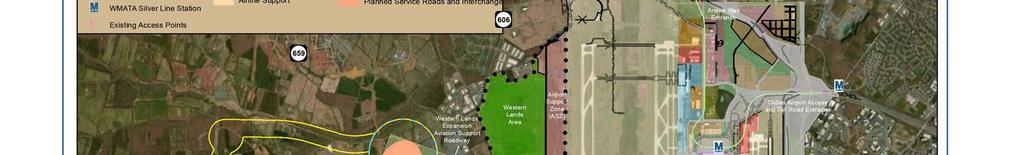
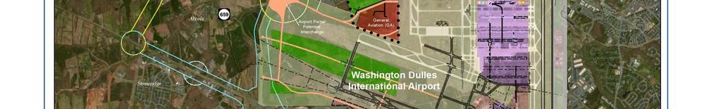
10 Chapter 1.0 PURPOSE AND NEED The Virginia Department of Transportation (VDOT), in cooperation with the Federal Highway Administration (FHWA) as the lead federal agency and the Federal Aviation Administration (FAA) as a cooperating agency, is evaluating options to address transportation needs west of the Washington Dulles International Airport (IAD) in Loudoun County, Virginia. Pursuant to the National Environmental Policy Act (NEPA) of 1969 and in accordance with FHWA regulations 1, this Environmental Assessment (EA) has been prepared to analyze the potential social, economic, and environmental effects associated with the proposed alternative solutions. 1.1 BACKGROUND Washington Dulles International Airport Expansion In April 2012, the Metropolitan Washington Airports Authority (MWAA) announced its initiative to solidify IAD as a major east coast transportation hub. To advance this initiative, MWAA plans to expand airport facilities west of Runway 1L-19R on three areas identified as the Western Land Area (WLA), Airport Support Zone (ASZ), and General Aviation (GA) site, which together are comprised of approximately 1,000 acres of currently undeveloped land, herein referenced as the Western Development Area. Within the Western Development Area, the WLA would consist of mixed general aviation support, cargo freight, commercial, and industrial development, while the ASZ would be limited to cargo facilities and infrastructure and the GA would provide services for local aircraft and unscheduled flights. As part of the planned expansion, IAD would increase its freight capacity and nearly double the existing 540,000 square footage of operational cargo space (Board of Supervisors, 2012c). Freight forecasts indicate an anticipated growth in total freight activity at IAD by approximately 105 percent between 2010 and 2030, with international freight predicted to increase by more than 700 million pounds (Ricondo & Associates, 2010, p. 27). The western development area would provide the additional cargo space necessary to accommodate this predicted freight growth. Emphasizing the increasing importance of this cargo expansion, MWAA has been soliciting interest for a major cargo distribution facility with operators such as FedEx and UPS as well as coordinating with Loudoun County to develop plans for a major aircraft manufacturing facility (MWAA, 2013). In order to facilitate direct access to the expanded air cargo activities and western development area, as well as provide general circulation within airport boundaries, several transportation portals were identified along VA Route 606 in the Washington Dulles International Airport Access and Parking Study (MWAA, 2004, p ). MWAA s 2011 Airport Land Use Plan (ALUP) includes reserved space for an interchange with VA Route 606 and internal road elements linking to the main passenger terminal area (MWAA, 2011). Planning for this internal public roadway network has occurred concurrently with the conceptual development of the western airport expansion. MWAA s current concepts for the western development area and connecting roadway facilities are illustrated in Figure 1 1. MWAA has indicated that this supporting roadway network is anticipated to be constructed as a two-lane facility by 2025, with plans for a four-lane expansion by 2040 (MWAA, 2013). 1 The National Environmental Policy Act (NEPA) and the US Department of Transportation, Federal Highway Administration s regulations for Environmental Impact and Related Procedures are codified in 42 USC 4332(c), as amended, and 23 CFR 771, respectively. 1

11
12 Local economic development officials identify the lack of roadway access to the western side of the airport as a major impediment to economic development activities in and around airport property. Acknowledging MWAA s expansion initiative and the need for transportation infrastructure improvements to airport access, the Loudoun County Board of Supervisors passed a resolution, Air Cargo Support for North-South Corridor, on November 7, 2012 supporting VDOT s efforts to construct the North-South Corridor from Dulles Airport to I-66 (Board of Supervisors, 2012b, p.16) Metrorail Silver Line MWAA is currently constructing a 23-mile extension of the existing Metrorail system, to be operated by the Washington Metropolitan Transit Authority (WMATA). MWAA included the Metrorail Silver Line in its long range planning for the airport 2 to provide a viable alternative connection and reduce travel times between downtown Washington, DC and the Dulles Corridor. The Metrorail Silver Line extension is planned to link the existing East Falls Church Metrorail Station with IAD, VA Route 606 at the Dulles Greenway, where a park and ride for express bus service is currently located, and Route 772 by Transit boardings are expected to be substantially higher than the existing corridor express buses due to the Metrorail s ability to run multiple train cars simultaneously (FTA, 2004). Furthermore, construction of the Metrorail stations would increase parking at the existing VA Route 606 Park and Ride from 750 spaces to 2,750 spaces and would introduce 3,300 spaces at the Route 772 station. Introduction of this service will create an increased demand on local roadway traffic west of IAD Loudoun County Land Use The introduction of the Metrorail and IAD expansion is reflective of the changes and rapid growth that have occurred in Loudoun County in recent decades, particularly in the eastern most portion of the county. Under Loudoun County s Revised Comprehensive Plan (Figure 1 2), this Suburban Policy Area, which is bounded by the Potomac River to the north, Braddock Road to the south, the Fairfax County line to the east, and Goose Creek, property lines, roadways, and power line easements to the west, has been designated as the primary location for suburban-scale residential and nonresidential development. The Suburban Policy Area serves as a transitional zone between the suburban growth surrounding metropolitan Washington, DC and the traditionally more rural areas of Loudoun County. Since the 1990s, the Suburban Policy Area experienced an increase in population by approximately 128 percent and the construction of more than 25,000 new homes (Board of Supervisors, 2011). Much of the growth has been concentrated in the Dulles Policy Subarea, which encompasses IAD and the areas immediately west of the airport, as evidenced by the 429 and 354 percent growth in population and housing units, respectively, since This is compared to 84 percent population and 76 percent housing unit growth overall within Loudoun County (Loudoun County Department of Management, 2012). Within this high growth Policy Subarea, several mixed-use and commercial developments are currently under development, including the Arcola Center, Dulles Landing, and Glascock Field at Stoneridge. As a result, Loudoun County has recently recommended to the Metropolitan Washington Council of Governments (MWCOG) that the area surrounding the US Route 50 / VA Route 606 interchange be designated as an Activity Center to be included in future regional forecasting. Activity Centers serve as one of the guiding principles for land use plans by the localities which feed into the cooperative planning forecasts produced by MWCOG (Loudoun County Department of Planning, 2013). 2 Planning for future rail transit station at IAD included in the 1985 Master Plan Update, MWAA s most recent Master Plan on file (FAA, 1985, p. 135). 3
13 Loudoun County Planned Land Use Residential Business Hybrid Retail Center Industrial Extractive Industry Transition Area Alternative 2 Alternative 3A Alternative 3B EVERGREE N MILLS RD À!( 659 BELMONT RIDGE RD Dulles Trade Center OLD OX RD Arcola EVERGREEN MILLS RD RACEFIELD LN À!( 659 À!( 621 À!( 606 JOHN MOSBY HWY GUM SPRING RD Washington Dulles International Airport 50 NORTHSTAR BLVD STONE SPRINGS BLVD Stoneridge TALL CEDARS PKWY GREENSTONE DR GUM SPRING RD À!( 659 À!( 606 LOUDON COUNTY PKWY RIDING CENTER DR South Riding Figure 1-2: Loudoun County Revised Comprehensive Plan Source: Loudoun County Miles
14 1.2 DESCRIPTION OF THE PROJECT STUDY AREA The project study area for this evaluation encompasses an approximate 3.5-mile diameter circle centered on Evergreen Mills Road (VA Route 621) between Gum Spring Road (VA Route 659) and Trade West Drive. As illustrated in Figure 1 3, the proposed project study area is generally bounded by Creighton Road to the north, Providence Ridge Drive to the south, IAD property to the east, and Lenah Run to west, focusing on the Dulles South area located in the southern region of Loudoun County. 1.3 NEEDS FOR THE PROJECT Based on the background information previously introduced above, three distinct transportation needs have been identified and are described in detail below Enhance Access to the Planned Western Development Area at Washington Dulles International Airport Existing Conditions Primary access to IAD is presently oriented towards the east of the airport, via the Dulles Airport Access and Toll Road (VA Route 267), where population and economic growth have historically been concentrated. In addition, Ariane Way located to the northeast of IAD provides a secondary access point to the existing cargo area, located on the north side of the airport within the main campus. The existing cargo infrastructure at IAD was constructed for low volume cargo distribution and cannot accommodate current space demands (Ricondo & Associates, 2010). These existing facilities no longer meet the requirements of current cargo carriers for large, high volume cargo operations at IAD. As a result, MWAA has evaluated numerous relocation and configuration options for long-term cargo development and has targeted the WLA expansion to address long-term cargo growth at IAD. According to the Dulles Loop Implementation Plan, 80 percent of traffic using VA Route 606, VA Route 28 and US Route 50 is not associated with travel to and from the airport meaning baseline traffic congestion on airport access roadways is impacting access to and from IAD (Michael Baker Jr., Inc., 2009). Locally, passengers and freight traffic must follow a circuitous route along VA Route 606 from US Route 50, or Sully Road (VA Route 28), to Ariane Way or the Dulles Airport Access and Toll Road (VA Route 267). Furthermore, traffic generated by the existing residential and mixed-use development within the project study area described in this EA, is confined to use the same routes. Regionally, passenger and freight traffic traveling to and from the airport must combine with substantial on-airport traffic traveling to and from Washington, DC and surrounding metropolitan areas, thus intensifying travel demand on the existing roadway facilities in and around IAD 3. As a result, Loudoun County recognizes the need to facilitate a more convenient access to and around IAD and has identified in their 2010 Revised Countywide Transportation Plan (CTP) (Figure 1 4) a limited and/or controlled access facility surrounding the perimeter of the Dulles Airport (Board of Supervisors, 2012a, p 2-20). 3 Local traffic accounted for approximately 78 percent of traffic in the immediate vicinity of IAD in 2005, according to Washington Airports Task Force s Dulles Airport Access Study (2005). 5
15 EVERGREEN RIDGE DR NORTHSTAR BLVD Brambleton LOUDOUN COUNTY PKWY FLEETWOOD R D À!( 774 CREIGHTON RD EVERGREEN M À!( 659 ILLS RD Study Area À!( 616 À!( 621 BELMONT RIDGE RD À!( 659 OLD OX RD Dulles Trade Center Arcola À!( GUM SPRING RD JOHN MOSBY HWY LOUDOUN COUNTY PKWY Washington Dulles International Airport Stoneridge À!( 659 South Riding BRADDOCK RD À!( 606 TALL CEDARS PKWY À!( 620 Figure 1-3: Proposed Project Study Area Source: Loudoun County Miles Miles 6
 Source: 2010 Revised Countywide Transportation Plan - Loudoun Co.")
16 Figure 1-4: Revised Loudoun County: Countywide Transportation Plan (Dulles South) Source: 2010 Revised Countywide Transportation Plan - Loudoun Co Miles 7
17 Future Conditions MWAA s proposed improvements for the Western Development Area calls for construction of a public roadway alignment along the northwest portion of the airport property to connect with undeveloped land dedicated for air cargo development, as well as other sites planned for general aviation and support services. Access to this future roadway network is confined to the north (Ariane Way) or to the east (Dulles Airport Access and Toll Road), as described above. Travel demand generated by the planned Western Development Area will increase the need for improved access west of IAD. The lack of sufficient access into the airport would impede the airport s foreseeable capacity to serve the Western Development Area in the future. As evidenced by FHWA s Freight Facts and Figures 2012, the demand for freight transportation is corollary with population and economic growth (Federal Highway Administration [FWHA], 2012b). In order to capitalize on the potential economic benefits offered by IAD, there is a need for improved movement of goods to and from the airport facilities. Landside access is a key consideration in determining how IAD can grow to accommodate additional cargo volume and how effectively it competes for discretionary cargo with other major freight airports (Cambridge Systematics, Inc., 2013). MWAA s future investment in the western lands expansion will require adequate access to the airport west of IAD to facilitate the intermodal connections between truck and air cargo freight, while maintaining the existing transportation infrastructure conditions in the project study area. In addition to supporting the region s sustained economic growth, IAD is also a gateway to national and international markets. IAD is especially attractive for international shipping companies, as it is located within an overnight road delivery trip to 56 percent of the United States population (MWAA, 2012b). There is a need for enhanced movement in and out of IAD, so that cargo freight services can easily transport goods and services globally and domestically Relieve Congestion Existing Conditions The project study area encompasses one of the fastest growing regions in the entire Washington, DC metropolitan area. In addition to the economic growth offered by IAD, increases in population and employment, unrelated to the airport facilities, have resulted in a great deal of economic development within the project study area. Table 1-1 illustrates the population and employment growth that is forecasted to occur within the project study area, Loudoun County, and the surrounding Washington Metropolitan Region. This population and employment growth is anticipated to add to traffic congestion during both peak and off-peak periods. 8
18 Table 1-1: Population and Employment Surrounding Dulles 1 Location Percent Change Population Employment Population Employment Population Employment Project study area 18,507 19,941 58,440 51, % 160% Loudoun County 312, , , ,449 54% 100% Metropolitan Region 6,625,384 3,992,382 8,660,708 5,617,587 31% 41% 1 According to an Economic Impact Study conducted by MWAA, the number of full- and part-time employees at IAD totaled 17,948 and overall, IAD was responsible for the creation of over 96,980 jobs with an associated $ billion of economic activity in Virginia in 2009 (Louis Berger Group, 2010). Source: Metropolitan Washington Council of Governments (2012, July). Round 8.1 Cooperative Forecasts. Retrieved from The growing populations west of IAD frequent US Route 50 and Old Ox Road (VA Route 606) / Loudoun County Parkway as part of their daily commutes or to access points of interest in and around the Washington Metropolitan Region. Table 1-2 defines the various LOS and their relationship to roadway segment congestion and Table 1-3 defines LOS as it relates to intersection operations. Table 1-2: Roadway Segment LOS Descriptions LOS Description Congestion Level A Free traffic flow with low volumes and high speeds. Speeds controlled by driver Low desires, speed limits, and physical roadway conditions. Vehicles almost completely unimpeded in their ability to maneuver within the traffic stream. B Stable traffic flow, with operating speeds remaining near free flow. Drivers still have Low reasonable freedom to maneuver with only slight restrictions within the traffic stream. C Stable flow, but with higher volumes, more closely controlled speed and Moderate maneuverability that is noticeably restricted. D Approaching unstable flow with tolerable operating speeds maintained, but Moderate considerably effected by changes in operating conditions. Freedom to maneuver within the traffic stream is more noticeably limited. E Unstable flow with low speed and momentary stoppages. Operations are at capacity Severe with no usable gaps within the traffic stream. F Forced flow with low speed. Traffic volumes exceed capacity and stoppages for long periods are possible. Severe Source: Highway Capacity Manual, Transportation Research Board, Table 1-3: Roadway Intersection LOS Descriptions LOS Description Congestion Level A Progression is extremely favorable and most vehicles arrive during the green phase. Low Many vehicles do not stop at all. Short cycle lengths may tend to contribute to low delay values. B Good progression with short cycle lengths. Some vehicle stoppage may occur, causing Low slightly higher levels of delay. C Higher delays resulting from fair progression, longer cycle lengths, or both. Individual Moderate cycle failure may begin to occur at this level, resulting in some overflow. The number of vehicles stopping is significant at this level, but many still pass through the intersection without stopping. D Longer delays may result from some combination of unfavorable progression, long cycle lengths, and lane flow rates conflicting with signal timing. Individual cycle failures are noticeable at this level 1. Moderate 9
19 LOS Description Congestion Level E High delay level indicative of poor progression, long cycle lengths, and high ratios of Severe conflicts between lane flow rates and signal timing. Individual cycle failures are frequent 1. F Arrival flow rates exceed the capacity of lane groups and conflicting signal timing. Evidenced by poor progression and long cycle lengths with many individual cycle failures 1. Considered to be unacceptable by most motorists. Severe 1 Cycle failure occurs when a given green phase does not serve queued vehicles, and overflows occur. Source: Highway Capacity Manual, Transportation Research Board, 2000, pp Average Daily Traffic (ADT) is defined as the total volume of traffic passing a point or segment of a highway facility in both travel directions. Similarly, Level of Service (LOS) is a qualitative measure of operational conditions within a traffic stream, based on criteria such as speed and travel time, freedom to maneuver, traffic interruptions, comfort and convenience (TRB, 2000). Table 1-4 indicates that US Route 50 is congested at a majority of the intersections in the project study area, especially during the peak travel hours. Likewise, traffic volumes on Old Ox Road (VA Route 606) have grown to exceed the capacity of the roadway, especially along the two-lane facility between Arcola Road and the Dulles Greenway. As presented in Table 1-5, an analysis of the existing ADT and LOS along roadway segments within the project study area reveals high levels of traffic and inhibited travel, indicative of severe congestion. Table 1-4: Existing and Future Level of Service 1 at Intersections within the Project study area Level of Service Intersection Existing (2012) No Build (2040) AM PM AM PM Route 50 at Stone Springs Boulevard C or Better C or Better C or Better E Route 50 at Gum Spring Road F F E 1 F 1 Route 50 at Hutchinson Farm Drive E C or Better E F Route 50 at Pinebrook Road D C or Better E F Route 50 at Loudoun County Parkway D D Route 50 at South Riding Boulevard C or Better C or Better C or Better D Route 50 at Poland Road/Tanner Lane C or Better C or Better D F Route 50 at Tall Cedars Parkway E C or Better E D Loudoun County Parkway at Evergreen Mills Road D C or Better F F Loudoun County Parkway at Tall Cedars Parkway C or Better C or Better F F Loudoun County Parkway at Old Ox Road (Route 606) F F Evergreen Mills Road at Belmont Ridge Road/Briarfield Lane F F F F Evergreen Mills Road at Gum Spring Road F D F F 1 LOS is shown for the worst peak hour and peak direction 2 This assumes future improvements at this intersection that are included in the CLRP. This includes widening Route 50 and installing additional turn lanes on Route 50 and Gum Spring Road. The existing Route 50 at Loudoun County Parkway intersection is an interchange in the future, per the CLRP. 10
20 Table 1-5: Existing and Future Traffic Volumes and Level of Service 1 for Roadway Segments within the Project study area Roadway Segment Existing (2012) No Build (2040) ADT LOS ADT LOS Fleetwood to Gum Spring Road (1.43 mi) 16,500 C or Better 24,800 C or Better Northstar Boulevard/Bi-County Parkway to Gum ,000 D Spring Road (0.9 mi) US Route Gum Spring Road to Loudoun County Parkway ( ,000 C or Better 59,000 F mi) Loudoun County Parkway to South Riding Boulevard (0.87 mi) 36,000 C or Better 54,900 C or Better Loudoun Tall Cedars Parkway to US Route 50 (0.38 mi) 13,500 C or Better 18,100 C or Better County US Route 50 to Evergreen Mills Road (0.60 mi) 30,500 C or Better 61,500 F Parkway Evergreen Mills Road to Arcola Road (0.62 mi) 21,500 D 51,000 F Gum Braddock Road to US Route 50 (2.01 mi) 17,000 C or Better 27,300 D Spring US Route 50 to Evergreen Mills Road (1.06 mi) Road 9,000 C or Better 19,000 F Evergreen Mills Road Tall Cedars Parkway Evergreen Mills Road from Belmont Ridge Road to Gum Spring Road (0.41 mi) 20,500 F 23,800 F Evergreen Mills Road from Gum Spring Road to Loudoun County Parkway (1.08 mi) 13,000 C or Better 15,600 F Tall Cedars Parkway (east of Loudoun County Parkway) 9,000 C or Better 23,300 C or Better 1 LOS is shown for the worst peak hour and peak direction Note: Northstar Boulevard/Bi-County Parkway is included in the regional CLRP and is anticipated to be completed by It is not included in the calculations for existing traffic conditions. Future Conditions Located in a region that is projected to substantially increase in population and employment in the future, the project study area is anticipated to see an increasing demand for travel. Consequently, as presented in Table 1-4 and Table 1-5, overall congestion and traffic volume for roadway segments and intersection delays in the project study area are expected to substantially worsen by the design year of Increased congestion would be experienced for local and regional traffic traveling to IAD along roadway segments in the project study area, and would hinder the anticipated freight truck traffic associated with IAD s planned cargo expansion. In addition to improving access for purposes of freight shipping, personal travel, and employment associated with IAD, roadway improvements are also needed to accommodate existing and forecasted local travel demands in the Dulles South area located in the Southern Region of Loudoun County Facilitate Intermodal Relationships Existing Conditions Currently, few project study area residents and employees (3.5%) use public transportation to travel to work (American Community Survey, 2011). Existing public transportation 4 in the project study area consists of Loudoun County s Commuter Bus Service, which presently provides ten morning and 14 afternoon peak-period express bus service routes to and from destinations that include West Falls Church 4 Considered Commuter Bus Service routes in Dulles South and Brambleton areas. 11
21 Metro, Rosslyn, the Pentagon, and other locations in downtown Washington, DC, for an average of 933 weekday riders (Loudoun County, 2013b). Because the existing transit system operates on the congested roadways described above, as well as others with similar conditions, it offers a limited alternative to automobile travel. The Metrorail Silver Line extension is intended to increase transit ridership and improve transportation service. The first phase of construction is nearly complete, with construction anticipated for completion by August 2013 and passenger service beginning in December Future Conditions The addition of the Silver Line extension would link individuals to employment and activity centers closer to Washington, DC with a more efficient, high-capacity transit option. The entire Metrorail Silver Line expansion is expected to reach full project completion and begin service to the Route 772 Station in Dulles by December 2018 (MWAA, 2012c). By 2025, anticipated ridership on the Silver Line is expected to attract approximately 4,485 and 6,961 boardings at the Route 606 and Route 772 stations, respectively (Federal Transit Administration [FTA], 2004). In order to provide connectivity to these Metrorail Silver Line stations locations and the mobility benefits that the system would offer, an enhanced transportation network is necessary. Increasing congestion exceeding roadway capacity would inhibit access, as traffic to and from the Metrorail Silver Line stations would be combined with local traffic, further worsening issues of volumes, congestion, and delays in the project study area. The future planned completion of the Loudoun County Parkway (VA Route 607) from Old Ox Road (VA Route 606) / Arcola Road (VA Route 842) to Ryan Road (VA Route 772) would enhance connections to the future Silver Line station at Ryan Road (VA Route 772). However, Old Ox Road (VA Route 606) / Loudoun County Parkway, from US Route 50 to Arcola Road (VA Route 842), are projected to be overcapacity (LOS F) in 2040 for those traveling from the Dulles South area. 1.4 SUMMARY The purpose of the proposed Dulles Air Cargo, Passenger, and Metro Access Highway (DACPMAH), presently under study, is to improve capacity on the existing roadway network in the project study area, based on three distinct transportation needs: Enhance access to the planned western development area at the Washington Dulles International Airport; Relieve congestion; and Facilitate intermodal relationships. 12
22 Chapter 2.0 ALTERNATIVES Four alternatives, which include the No Build Alternative and three Build Alternatives, have been developed for study in this EA and are described in the sections that follow. Alternatives development was based on initial project scoping and screening efforts, which included public and agency involvement, consideration of environmental concerns, preliminary engineering issues, and their ability to meet Purpose and Need. The proposed DACPMAH would extend from the interchange of the planned Northstar Boulevard/Bi-County Parkway (VA Route 411) and US Route 50 to the existing intersection of Old Ox Road (VA Route 606) and Arcola Road (VA Route 842), where future Washington Dulles International Airport (IAD) access roads and an extension of the Loudoun County Parkway are planned to converge. 2.1 ALTERNATIVES CARRIED FORWARD No Build Alternative (Alternative 1) The No Build Alternative serves as a benchmark for comparison to the proposed project alternatives. The No Build Alternative would include all planned and programmed transportation improvements in the project study area that have been approved and adopted for implementation by 2040, as identified in the most recent National Capital Region s Financially Constrained Long-Range Plan (CLRP). Prepared by the National Capital Region Transportation Planning Board (TPB), which is the designated Metropolitan Planning Organization (MPO) for the Washington, DC region under the MWCOG, the CLRP includes projected transit and traffic, demographics, and air quality conditions through the 2040 horizon year. The roadway projects listed in the CLRP that would affect the project study are illustrated on Figure 2 1 and include the following: Construction of the Loudoun County Parkway (VA Route 607) to four lanes from Old Ox Road (VA Route 606) / Arcola Road (VA 842) to Ryan Road (VA Route 772); Widening of US Route 50 from four to six lanes from Gum Spring Road (VA Route 659) to Sully Road (VA Route 28); Completion of the new Bi-County Parkway (VA Route 411), a four lane limited access facility from VA Route 234 in Prince William County at I-66 to US Route 50, west of Dulles Airport along the Northstar Boulevard alignment in Loudoun County; Widening of Gum Spring Road (VA Route 659) from two lanes to a four lane divided facility from Braddock Road (VA Route 620) to US Route 50; Reconstruction and widening of Old Ox Road (VA Route 606) from two to four lanes from Moran Road (VA Route 634) to Evergreen Mills Road (VA Route 621); Construction of an interchange at US Route 50 and Old Ox Road (VA Route 606) / Loudoun County Parkway; and Construction of Tall Cedars Parkway to a four lane divided facility from Gum Spring Road (VA Route 659) to Pinebrook Road. Transit projects, as illustrated in Figure 2 2 that are listed in the CLRP and included for consideration under the No Build Alternative include the following: 13
23 H Proposed Interchange Alternative 2 Alternative 3A Alternative 3B EVERGREEN MILLS RD À!( 659 BELMONT RIDGE RD Alternative 2 CLRP #1878 Loudoun County Parkway (VA 607) Construction (4 Lanes) Dul les Trade Center CLRP #2654 Old Ox Road (VA 606)/ Dulles Loop Reconstruction Widening to 4 Lanes OLD OX RD EVERGREEN M ILLS RD Arcola H RACEFIELD LN JOHN MOSBY HWY GUM SPRING RD À!( 659 À!( 621 À!( 606 MWAA Western Lands Expansion Aviation Support Roadway Washington Dulles International Airport CLRP #1923 Northstar Blvd (VA 411)/ Tri-County Parkway Construction (4 Lanes) NORTHSTAR BLVD STONE SPRINGS BLVD Stoneridge TALL CEDARS PKWY GREENSTONE DR 50 GUM SPRING RD CLRP #2585 Gum Springs Road (VA 659) Widening to 4 Lanes CLRP #3068 Tall Cedars Parkway Extension (4 Lanes) Alternative 3 À!( 659 À!( 606 RIDING CENTER DR LOUDOUN COUNTY PKWY CLRP #2875 H US 50 Interchange at Loudoun County Parkway South Riding CLRP #1906 US 50 Widening to 6 Lanes VDOT Figure 2-1: CLRP Planned Roadway Improvements and Location Study Corridors Source: Loudoun County Miles 14
24 Æü ³ Alternative 2 Alternative 3A Alternative 3B Airport Boundary Park and Ride Lot Planned Metro Rail WMATA Silver Line Station À!( 772 À!( 267 Silver Line Route 772 Station (Future) Dulles North Transit Center (Existing) Æü Silver Line Route 606 Station (Future) À!( 774 Brambleton À!( 659 Æü Brambleton Park and Ride (Existing) À!( 606 Silver Line Innovation Center Station (Future) Arcola À!( 621 Silver Line Dulles International Airport Station (Future) Æü Stoneridge/Dulles South Park and Ride (Existing) Stoneridge Washington Dulles International Airport À!( South Riding East Gate Park and Ride (Future) Æü LOUDOUN COUNTY FAIRFAX COUNTY À!( 657 VDOT Figure 2-2: CLRP Planned Transit Improvements Source: Loudoun County Miles Miles 15
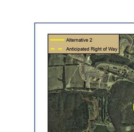
25 Park and Ride Lot: US Route 50 at Stone Ridge 150 spaces Park and Ride Lot: US Route 50 Dulles at East Gate 200 spaces Park and Ride Lot: Brambleton at Creighton Road (VA Route 774) 100 space expansion Dulles Corridor Metrorail (Silver Line): East Falls Church Metrorail Station to Wiehle Avenue Dulles Corridor Metrorail (Silver Line): Wiehle Avenue to Route 772 Under the No-Build Alternative, no additional roadway infrastructure, beyond those projects funded in the CLRP, are assumed to be in place to the west of the airport by The No-Build Alternative would not satisfy the identified needs of the project. It would not enhance the planned western access to IAD, relieve congestion, nor would it facilitate intermodal relationships Build Alternatives Carried Forward Also shown previously in Figure 2 1, two Location Study Corridors (Alternative 2 and Alternative 3) incorporating three potential Build Alternatives (Alternative 2, 3A, and 3B) have been identified for study in this EA as potential alignments for the proposed Dulles Air Cargo, Passenger, and Metro Access Highway. The sections that follow provide detailed descriptions of the build alternatives that remain under consideration for the proposed project. The Location Study Corridors for each Build Alternative have been developed to identify the project footprint and are generally 1,000 feet wide along the mainlines, with circular project study areas where interchange connections would be made. The Location Study Corridors are described in greater detail in Chapter 3.0 as they are used as boundaries for the inventory of environmental resources to allow for a relative comparison of each Build Alternative. Alternative 2: Proposed New Location Alternative 2 (Figure 2 3) would originate at US Route 50, approximately 2.2 miles west of its existing intersection with the Loudoun County Parkway (Route 607), in the location where the Bi-County Parkway (VA Route 411) interchange is planned. Alternative 2 would connect to the proposed interchange allowing for all movements to and from US Route 50 and the proposed Bi-County Parkway (VA Route 411) 5. From US Route 50, the proposed alternative would follow a new alignment located within the same corridor as Loudoun County s proposed Northstar Boulevard, extending approximately one-mile northeast before turning due east approximately 0.25 mile south of Evergreen Mills Road (VA Route 621). The alignment would continue east for approximately 1.7 miles, with an overpass at Belmont Ridge Road (VA Route 659) and Evergreen Mills Road (VA Route 621) until intersecting with existing Old Ox Road (VA Route 606) / Loudoun County Parkway. This connection would consist of a fullaccess interchange with Old Ox Road (VA Route 606), the planned Loudoun County Parkway (VA Route 607) extension, and planned airport connector roads. Alternative 2 would be a limited access highway, specifically, with no direct access to adjoining properties. Instead, connections with arterial roadways would be provided via US Route 50, Bi-County Parkway, Old Ox Road (VA Route 606), planned extension of Loudoun County Parkway (VA Route 607) and the planned airport connector roads. As shown in the typical section (See Figure 2 4) for Alternative 2, the proposed alignment would consist of a four-lane divided principal arterial with a design speed of 60 miles per hour. 5 If for any reason the Bi-County Parkway is not constructed, US Route 50 would remain a logical termini and the interchange between US Route 50 and the proposed DACPMAH would be designed accordingly. 16
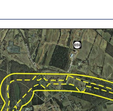
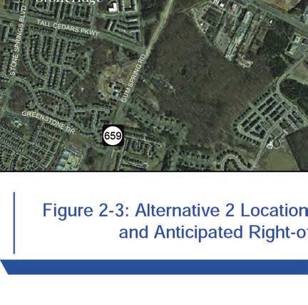
26
, the planned Loudoun County Parkway (VA Route 607) extension, and planned IAD")
27 Figure 2 4: Alternative 2 Typical Roadway Section Alternative 3 Alternative 3 would consist of improvements along existing US Route 50 and Old Ox Road (VA Route 606) from the location of the planned US Route 50 interchange at Bi-County Parkway 5 to a proposed fullaccess interchange with Old Ox Road (VA Route 606), the planned Loudoun County Parkway (VA Route 607) extension, and planned IAD connector roads as shown previously on Figure 1 1. Along the Alternative 3 alignment, two potential improvement options, described below, were evaluated independently for environmental resources and potential project impacts. The footprint of the Location Study Corridors for Alternative 3 remains nearly identical, with only a slight variation at the intersection of Gum Spring Road and US Route
28 Alternative 3A US Route 50 Elevated Alternative 3A (Figure 2 5) would be a 4-lane divided limited access principal arterial, on an aerial structure within the median of US Route 50. In order to construct the aerial structure, the existing US Route 50 median would need to be widened, resulting in the at-grade lanes for US Route 50 being shifted outward from the widened median. Upon returning to grade parallel to Loudoun County Parkway, Alternative 3A would run parallel to Loudoun County Parkway as a separated 4-lane divided principal arterial but at-grade instead of elevated. The proposed typical sections for Alternative 3A are shown on Figures 2 6 and 2 7. Figure 2 6: Alternative 3A Typical Roadway Section (US Route 50) Figure 2 7: Alternative 3A Typical Roadway Section (VA Route 606) 19
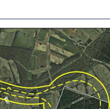
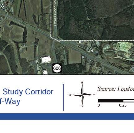
29 Alternative 3A Anticipated Right of Way EVERGREEN MILLS RD À!( 659 BELMONT RIDGE RD Dulles Trade Center OLD OX RD EVERGREEN MILLS RD Arcola RACEFIELD LN À!( 659 À!( 621 À!( 606 JOHN MOSBY HWY GUM SPRING RD Washington Dulles International Airport 50 STONE SPRINGS BLVD Stoneridge TALL CEDARS PKWY GUM SPRING RD LOUDOUN COUNTY PKWY NORTHSTAR BLVD GREENSTONE DR À!( 659 À!( 606 RIDING C ENTE R DR South Riding VDOT Figure 2-5: Alternative 3A Location Study Corridor and Anticipated Right-of-Way Source: Loudoun County Miles 20
30 Alternative 3A would originate at US Route 50 and the planned Bi-County Parkway interchange and provide full connections to the planned Bi-County Parkway (VA Route 411) 5. Alternative 3A would provide access to the elevated highway at the interchange with the Bi-County Parkway for US Route 50 westbound and Bi-County Parkway traffic and at the Loudoun County Parkway interchange for US Route 50 eastbound. From the interchange at Bi-County Parkway (VA Route 411), Alternative 3A would follow along the US Route 50 alignment in an elevated section, within the roadway median. At the planned interchange with Loudoun County Parkway, the roadway would travel north over the Loudoun County Parkway and return to grade on the east side of Old Ox Road (VA 606) / Loudoun County Parkway, on Dulles Airport property. Alternative 3A would provide a connection to US Route 50 eastbound and from US Route 50 westbound at this future interchange. From there the facility would extend parallel to Old Ox Road (VA Route 606) / Loudoun County Parkway approximately 1.7 miles to the planned airport connector roads. Flyover ramps would be provided along this portion of Alternative 3A to provide a connection from northbound Alternative 3A to northbound Loudoun County Parkway and from southbound Loudoun County Parkway to southbound Alternative 3A. A full-access interchange with Old Ox Road (VA Route 606), the planned Loudoun County Parkway (VA Route 607) extension, and planned airport connector roads is proposed. Alternative 3B Loudoun County: Countywide Transportation Plan Alternative 3B (Figure 2 8) would originate at the planned full-access interchange of US Route 50 and the Bi-County Parkway (VA Route 411) 5. To meet Loudoun County s CTP (Loudoun County, 2012a), which identifies US Route 50 as a six (6) lane freeway at this location, US Route 50 would be widened from four (4) lanes to six (6) lanes from the planned interchange of US Route 50 and Bi-County Parkway (VA Route 411) to Gum Spring Road (VA Route 659). At-grade access to all properties would be closed along US Route 50 from Bi-County Parkway to Loudoun County Parkway in order to provide limited access along this roadway. Access to properties to the south would be provided from Tall Cedars Parkway. Access to properties to the north would be provided from a parallel frontage road accessed from Gum Spring Road (VA Route 659). The Loudoun County CTP identifies proposed Glascock Boulevard as a parallel facility to the north of US Route 50, but this facility is not currently included in the CLRP and therefore not assumed to be in place as part of this study. Should Glascock Boulevard be constructed prior to the construction of Alternative 3B, Glascock Boulevard could possibly function in place of the proposed frontage road. However, Alternative 3B presumes a separate frontage road would be provided within the proposed corridor along US Route 50. A full access interchange at Gum Spring Road (VA Route 659) and US Route 50 would also be provided, in order to conform to Loudoun County s adopted CTP. 21
31 Alternative 3B Anticipated Right of Way ERGREEN MILLS RD À!( 659 BELMONT RIDGE RD Dulles Tra de Center OLD OX RD Arcola EVERGREEN MILLS RD RACEFIELD LN À!( 659 À!( 621 À!( 606 JOHN MOSBY HWY GUM SPRING RD Washington Dulles International Airport 1000' 50 STONE SPRINGS BLVD Stoneridge TALL CEDARS PKWY GUM SPRING RD LOUDOUN COUNTY PKWY NORTHSTAR BLVD GREENSTONE DR À!( 659 À!( 606 RIDING CENTE R DR VDOT Figure 2-8: Alternative 3B Location Study Corridor and Anticipated Right-of-Way South Riding Source: Loudoun County Miles 22
32 A full access interchange would be provided at Old Ox Road (VA 606) / Loudoun County Parkway and US Route 50 where Alternative 3B would follow Old Ox Road (VA Route 606) / Loudoun County Parkway to the north. Under Alternative 3B, Old Ox Road (VA Route 606) / Loudoun County Parkway would be upgraded to an eight (8) lane limited access facility to match the Loudoun County CTP designation of the facility as a freeway. The Loudoun County CTP shows at-grade intersections at proposed Glascock Boulevard, Evergreen Mills Rd (VA Route 621) and Arcola Boulevard (VA Route 842). However, at grade intersections are generally not allowed within a limited access freeway. Therefore, Alternative 3B assumes a frontage road will be provided within the proposed corridor along Old Ox Road (VA Route 606) / Loudoun County Parkway in the southbound direction to provide limited access to and from Evergreen Mills Road (VA Route 621). The frontage road is anticipated to be for the southbound direction only. Alternative 3B would terminate as full-access interchange with Old Ox Road (VA Route 606), the planned Loudoun County Parkway (VA Route 607) extension, and planned airport connector roads. This proposed alternative would be a six(6) lane limited access facility along US Route 50 and an eight (8) lane limited access highway along Old Ox Road (VA Route 606) / Loudoun County Parkway, as shown in Figure 2-4, with design speeds of 60 miles per hour. The proposed typical sections for Alternative 3B are shown on Figures 2 9 and Figures 2 9: Alternative 3B Typical Roadway Section (US Route 50) Figure 2 10: Alternative 3B Typical Roadway Section (VA Route 606) 23
33 2.2 BENEFITS OF ALTERNATIVES AND ABILITY TO MEET NEEDS The Build Alternatives described in the preceding sections have been retained for evaluation in this EA based on their ability to meet the identified transportation needs in the project study area Enhance Planned Western Access to Washington Dulles International Airport All three of the proposed build alternatives would meet the need for improved access to IAD. The implementation of a limited access highway extending from the planned interchange of the Northstar Boulevard/Bi-County Parkway (VA Route 411) and US Route 50 to the intersection of VA Route 606 and Arcola Road would provide better access into and around the IAD by circumventing the circuitous route that is currently required for traffic traveling to and from the south and west to enter into the airport. These alternatives would serve the western lands expansion and facilitate airport access for freight traffic to development facilities within IAD that include the midfield area, airport support zone, and western area lands, all which are planned for the integration of cargo facilities. As evidenced by FHWA s Freight Facts and Figures 2012, the demand for freight transportation is corollary with population and economic growth (FHWA, 2012b). Specifically, between 2010 and 2030, the demand for freight (goods) coming in and out of IAD is projected to grow at an annual rate of four percent and growth of freight activity in the region, driven by IAD and supporting infrastructure can be expected to lead to proportional gains in direct and indirect employment (Ricondo & Associates, 2010). Assuming that the current relationship between the projected air cargo tonnage and employment holds true to 2030, the additional 567,000 tons of cargo would lead to an additional 2,070 jobs and $155 million in annual wages in the year Landside access will remain a key consideration in determining how the airport grows to accommodate additional cargo volume and how effectively it competes for discretionary cargo with other major freight airports (Cambridge Systematics, Inc., 2013). All three build alternatives provide enhanced access to IAD, which will improve movement of goods to and from the airport facilities. This enhanced movement in and out of IAD, will allow cargo freight carriers to more easily transport goods and services globally and domestically. Furthermore, the overall anticipated increase in passenger trips and airport employment traveling from the west, would be directed to this new access point to the west of the airport Relieve Congestion The proposed alternatives are intended to relieve congestion on the existing roadway network in the project study area by providing additional highway capacity for travel routes west of IAD. Although the continued residential and employment growth expected in the Dulles Policy Subarea combined with the planned addition of a western access to IAD would presumably create additional traffic demand in the project study area, the increased roadway capacity offered by each alternative would provide greater overall LOS under Alternatives 2 and 3B and sustained levels of services under Alternative 3A, compared to the No Build Alternative (Appendix A: Transportation and Traffic Technical Report). Table 2-1 lists the anticipated LOS for roadway segments within the project study area. 24
VTrans2040 Multimodal Transportation Plan Corridors of Statewide Significance Needs Assessment North-South Corridor
 VTrans2040 Multimodal Transportation Plan Corridors of Statewide Significance Needs Assessment North-South Corridor Table of Contents I. Corridor Overview Demographics and Economic Trends Corridor Travel
VTrans2040 Multimodal Transportation Plan Corridors of Statewide Significance Needs Assessment North-South Corridor (G)
") VTrans2040 Multimodal Transportation Plan Corridors of Statewide Significance Needs Assessment North-South Corridor (G) UV 234 Table of Contents I. Corridor Overview Demographics and Economic Trends Corridor
VTrans2040 Multimodal Transportation Plan Corridors of Statewide Significance Needs Assessment North-South Corridor (G) UV 234 Table of Contents I. Corridor Overview Demographics and Economic Trends Corridor
April 12, Dear Chairman Wojahn and Members of the Transportation Planning Board:
 April 12, 2014 The Honorable Patrick Wojahn National Capital Region Transportation Planning Board c/o Metropolitan Washington Council of Governments 777 North Capital Street, NW, Suite 300 Washington,
EVALUATION OF ALTERNATIVES CARRIED FORWARD
 1 EVALUATION OF ALTERNATIVES CARRIED FORWARD This chapter presents a comparative evaluation of the alternatives carried forward in this Final Environmental Impact Statement (EIS). The intent of this evaluation
Evaluation of Alternatives
 Chapter 9.0 Evaluation of Alternatives Chapter 9.0 provides a summary evaluation of the No Build Alternative and the Preferred Alternative. The evaluation contained within this chapter is an assessment
12 Evaluation of Alternatives
 12 Evaluation of Alternatives This chapter evaluates the effectiveness of the No-Build Alternative and the proposed METRO Blue Line Light Rail Transit (BLRT) Extension project based on the information
SOUTHWEST LRT (METRO GREEN LINE EXTENSION)
") 8 Evaluation of Alternatives This chapter evaluates the effectiveness of the No Build Alternative and the Southwest Light Rail Transit (LRT) Project (the Project) based on the information contained in
8 Evaluation of Alternatives This chapter evaluates the effectiveness of the No Build Alternative and the Southwest Light Rail Transit (LRT) Project (the Project) based on the information contained in
NEPA and Design Public Hearings
 NEPA and Design Public Hearings Monday, December 5, 2016 Washington-Lee High School 1301 N. Stafford Street Arlington, VA 22201 Thursday, December 8, 2016 Mary Ellen Henderson Middle School 7130 Leesburg
Commonwealth Transportation Board Sean T. Connaughton 1401 East Broad Street (804) Chairman Richmond, Virginia Fax: (804)
 Chairman Richmond, Virginia Fax: (804)") Commonwealth Transportation Board Sean T. Connaughton 1401 East Broad Street (804) 786-1830 Chairman Richmond, Virginia 23219 Fax: (804) 786-2940 RESOLUTION OF THE COMMONWEALTH TRANSPORTATION BOARD Made
Commonwealth Transportation Board Sean T. Connaughton 1401 East Broad Street (804) 786-1830 Chairman Richmond, Virginia 23219 Fax: (804) 786-2940 RESOLUTION OF THE COMMONWEALTH TRANSPORTATION BOARD Made
AMENDED RECORD OF DECISION. by the Federal Transit Administration. Dulles Corridor Metrorail Project Fairfax and Loudoun Counties, Virginia
 AMENDED RECORD OF DECISION by the Federal Transit Administration Fairfax and Loudoun Counties, Virginia DECISION The Federal Transit Administration (FTA), in accordance with 23 CFR part 771, the regulation
Route 7 Connector Ramp MODIF IE D I N T ER C H A N G E M OD IFICATIO N R E PO RT TRA N S F O R M I : I N S ID E THE BE LTWAY
 STATE PROJECT NUMBER: 0066-96A-493,P101, C501, B686; UPC: 110629 FEDERAL PROJECT NUMBER: NHPP-066-1(356) FAIRFAX COUNTY, VIRGINIA TRA N S F O R M I - 6 6 : I N S ID E THE BE LTWAY Route 7 Connector Ramp
WELCOME. Schedule. Contact Information. Please Provide Written Comments
 WELCOME Schedule April 18, 2012 Open House: 6:30 p.m. to 8:30 p.m. Project Presentation: 7:00 p.m. Mary Ellen Henderson Middle School 7130 Leesburg Pike Falls Church, VA 2203 Contact Information Kala Leggett
ATTACHMENT A. Detailed Study Scope. I-66 (Inside) Multi-modal Study Scope
 Multi-modal Study Scope") ATTACHMENT A Detailed Study Scope I-66 (Inside) Multi-modal Study Scope EXECUTIVE SUMMARY The Virginia Department of Transportation (VDOT) seeks consultant assistance in identifying and evaluating a range
ATTACHMENT A Detailed Study Scope I-66 (Inside) Multi-modal Study Scope EXECUTIVE SUMMARY The Virginia Department of Transportation (VDOT) seeks consultant assistance in identifying and evaluating a range
Categorical Exclusion (CE)
") Categorical Exclusion (CE) Project Information Project Name: I-66 ITB West Falls Church Metro Garage Access Federal Project#: NHPP-066-1(356) Project Number: 0066-96A-493, B686, C501, P101 Project Type:
Categorical Exclusion (CE) Project Information Project Name: I-66 ITB West Falls Church Metro Garage Access Federal Project#: NHPP-066-1(356) Project Number: 0066-96A-493, B686, C501, P101 Project Type:
APPENDIX H- ALTERNATIVES PREVIOUSLY CONSIDERED
 APPENDIX H- ALTERNATIVES PREVIOUSLY CONSIDERED APPENDIX H: ALTERNATIVES PREVIOUSLY CONSIDERED This appendix provides an overview of the process that led to the selection of the Locally Preferred Alternative
AIR QUALITY TECHNICAL MEMORANDUM
 AIR QUALITY TECHNICAL MEMORANDUM AIR QUALITY TECHNICAL MEMORANDUM GOLDEN GLADES INTERCHANGE PD&E STUDY Miami-Dade County, Florida Financial Management Number: 428358-1-22-01 Efficient Transportation Decision
BOARD OF SUPERVISORS BUSINESS MEETING ACTION ITEM. Loudoun County Parkway/US Route 50 Conceptual Interchange Design. Blue Ridge & Dulles
 Date of Meeting: June 7, 2016 # 9 BOARD OF SUPERVISORS BUSINESS MEETING ACTION ITEM SUBJECT: ELECTION DISTRICTS: CRITICAL ACTION DATE: STAFF CONTACTS: Loudoun County Parkway/US Route 50 Conceptual Interchange
NEED ECONOMIC TRANSPORTATION LOCATIONS EXAMPLE
 A. Enhance multimodal networks and facilities around transit access points such as existing and emerging rail stations, high capacity bus stops, and intermodal transfer centers There is a need for improved
vi Figures viii Summary S.1
 Contents Contents iii Tables vi Figures viii Summary S.1 Chapter 1: Purpose and Need Project History A.1 Project Description A.2 Project Purpose A.5 Transportation Need A.6 Highway Capacity and Congestion
Purpose of the Public Hearing
 www.virginiadot.org Public Hearings Interstate 66 - Outside the Beltway Tier 1 Draft Environmental Impact Statement From U.S. Route 15 To I-495 Prince William and Fairfax Counties Wednesday, March 13,
INFORMATION REQUIRED FOR PROBABLE CATEGORICAL EXCLUSION (SECTION (d))
)") Grant Applicant: Proposed Project: Date: August 03, 2010 Northern Virginia Transportation Commission, Arlington County Government, and Washington Metropolitan Area Transit Authority Crystal City/Potomac
Grant Applicant: Proposed Project: Date: August 03, 2010 Northern Virginia Transportation Commission, Arlington County Government, and Washington Metropolitan Area Transit Authority Crystal City/Potomac
Summary. Preliminary Alternative Development and Screening. DEIS July 23, 2018
 What is the Carolina Crossroads Project? The South Carolina Department of Transportation (SCDOT), in cooperation with the Federal Highway Administration (FHWA), is proposing to upgrade and redesign a key
Interstate 66 Tier 1 Environmental Impact Statement Public Hearing
 Interstate 66 Tier 1 Environmental Impact Statement Public Hearing 1 Project Corridor Study Process / Tiering Approach Tier 1 EIS focuses on broad issues - Purpose and need - Mode / Technology choice -
Northern Virginia Region Draft Needs Summary
 Needs Map: Need A A DEMAND The ability of communities around transit stations (particularly the areas within 1-2 miles of the stations and other travel hubs) to attract skilled workers and grow businesses
ALBION FLATS DEVELOPMENT EXISTING TRAFFIC CONDITIONS AND POTENTIAL IMPACTS
 EXISTING TRAFFIC CONDITIONS AND POTENTIAL IMPACTS FINAL REPORT SEPTEMBER 2010 TABLE OF CONTENTS 1.0 INTRODUCTION 1 2.0 EXISTING TRAFFIC CONDITIONS 2 3.0 FUTURE TRAFFIC CONDITIONS 3 4.0 POTENTIAL IMPACTS
6.0 CONGESTION HOT SPOT PROBLEM AND IMPROVEMENT TRAVEL DEMAND MODEL ANALYSIS
 6.0 CONGESTION HOT SPOT PROBLEM AND IMPROVEMENT TRAVEL DEMAND MODEL ANALYSIS 6.1 MODEL RUN SUMMARY NOTEBOOK The Model Run Summary Notebook (under separate cover) provides documentation of the multiple
LANDSIDE FACILITIES AIRLINE TERMINAL FACILITIES INVENTORY 5.0 INTRODUCTION C H A P T E R 1 CHAPTER 5
 C H A P T E R 1 INVENTORY AIRLINE TERMINAL FACILITIES INVENTORY CHAPTER 5 LANDSIDE FACILITIES 5.0 INTRODUCTION This chapter focuses on the landside circulation and access system at the Spokane International
Future Build Alternative Traffic Forecasts and Level of Service Analysis
 4.2.10 Future Build Alternative Traffic Forecasts and Level of Service Analysis For the five Build Alternatives, study intersections within one mile of potential station locations were analyzed, as it
This document has been developed to provide context to the Board as part of the strategic planning process. Regional development and travel trends
 1 This document has been developed to provide context to the Board as part of the strategic planning process. Regional development and travel trends and forecasts are provided, including population, employment,
MEMORANDUM. Date: July 14, 2006 Project #: To: US 97 & US 20 Refinement Plan Steering Committee
 MEMORANDUM Date: July 14, 2006 Project #: 6389 To: US 97 & US 20 Refinement Plan Steering Committee From: Sonia Hennum, P.E., Andrew Cibor, E.I.T., & Julia Kuhn, P.E. Project: US 97 & US 20 Refinement
1.1 Purpose of the Project
 Chapter 1 Purpose and Need for East Link Project 1.1 Purpose of the Project The purpose of the East Link Project is to expand the Sound Transit Link light rail system from Seattle to Mercer Island, Bellevue
Transportation Facility Inventory
 CHAPTER 3 Transportation Element Section 3.1 Introduction Movement of people, goods, and services within and through the Town is an integral part of everyday life for the citizens of Hull. Decisions made
Fairfax Transportation Committee I-66 Multimodal Improvements Inside the Beltway. January 20, 2015
 Fairfax Transportation Committee I-66 Multimodal Improvements Inside the Beltway January 20, 2015 I-66 Multimodal Improvements I-66 Multimodal Study (2012 / 2013) Tolling element Multimodal solutions Future
Draft Environmental Assessment Terminal B/C Redevelopment, Secure National Hall, and Related Improvements
 JUNE 2016 RONALD REAGAN WASHINGTON NATIONAL AIRPORT Draft Environmental Assessment Terminal B/C Redevelopment, Secure National Hall, and Related Improvements PREPARED BY: Ricondo & Associates, Inc. IN
Categorical Exclusion (CE)
") Categorical Exclusion (CE) Project Information Project Name: Federal Project#: Project Number: 0029-002-135, D624, P101 Project Type: Construction UPC: 77383 Charge Number: Route Number: 29 Route Type:
Categorical Exclusion (CE) Project Information Project Name: Federal Project#: Project Number: 0029-002-135, D624, P101 Project Type: Construction UPC: 77383 Charge Number: Route Number: 29 Route Type:
FOR INTERSTATE 81 AND ROUTE 37 INTERCHANGE FREDERICK COUNTY, VIRGINIA MILEPOST 310
 INTERCHANGE MODIFICATION REPORT FOR INTERSTATE 81 AND ROUTE 37 INTERCHANGE FREDERICK COUNTY, VIRGINIA MILEPOST 310 PREPARED BY: VIRGINIA DEPARTMENT OF TRANSPORTATION STAUNTON DISTRICT DECEMBER 13, 2006
TRANSPORTATION PROJECT REPORT DRAFT CONCEPTUAL ACCESS MODIFICATION PROPOSAL OCTOBER 2002
 TRANSPORTATION INTERSTATE 87 INTERCHANGE 11A TOWN OF MALTA SARATOGA COUNTY, NY DRAFT CONCEPTUAL ACCESS MODIFICATION PROPOSAL OCTOBER 2002 PROJECT REPORT NEW YORK STATE DEPARTMENT OF TRANSPORTATION JOSEPH
9.0 I-26 & I-526 Interchange Improvements
 9.0 I-26 & I-526 Interchange Improvements The I-26 & I-526 System-to-System interchange currently consists of a combination of directional and loop ramps providing for all movements from one Interstate
Chapter 2: Alternatives
 Chapter 2: Alternatives Introduction An Environmental Impact Statement (EIS) is a procedural document. In other words, the environmental planning process follows a logical sequence of development. Subsequent
On behalf of the Carolina Crossroads project team we thank you for taking the time to attend this meeting.
 On behalf of the Carolina Crossroads project team we thank you for taking the time to attend this meeting. Located in the heart of South Carolina, the I-20/26/126 Corridor is the crossroads of the state
CHAPTER 2 - TRAVEL DEMAND MODEL DEVELOPMENT
 CHAPTER 2 - TRAVEL DEMAND MODEL DEVELOPMENT 2.1 EXISTING TRAVEL DEMAND MODEL In order to accurately project future year traffic volumes within this regional study area, it was first necessary to construct
Regional Bus Rapid Transit
 Regional Bus Rapid Transit Efforts Board Transportation Committee October 20, 2009 There are a Variety of Regional Bus Rapid Transit Study Efforts They include: NVTA s TransAction 2030 Plan Transportation
THE PROJECT. Executive Summary. City of Industry. City of Diamond Bar. 57/60 Confluence.
 THE PROJECT A freeway segment ranked 6th worst in the Nation, with levels of congestion, pollution and accidents that are simply unacceptable and which have Statewide and National implications. Executive
ELEMENT M GROWTH MANAGEMENT
 Growth Management ELEMENT M GROWTH MANAGEMENT GOAL: To ensure that growth and development are integrally planned with, and phased concurrently with, the City of Irvine s ability to provide an adequate
TABLE OF CONTENTS 3.0 AFFECTED ENVIRONMENT AND ENVIRONMENTAL CONSEQUENCES
 TABLE OF CONTENTS 1.0 PURPOSE AND NEED -------------------------------------------------------------------------------------------- 1-1 1.1 STUDY AREA -----------------------------------------------------------------------------------------------------
UPTOWN TRAFFIC IMPACT ANALYSIS
 UPTOWN TRAFFIC IMPACT ANALYSIS This memorandum summarizes the results of the traffic analysis conducted to evaluate the traffic operations of the intersections along Post Oak Boulevard within Uptown Houston
MOBILITY AND ALTERNATIVES ANALYSIS
 6 MOBILITY AND ALTERNATIVES ANALYSIS BACK OF SECTION DIVIDER 6.0 Mobility and Alternatives Analysis Travel demand analysis provides a framework for the identification of transportation facilities and services
SUMMARY S.1 PROJECT DESCRIPTION AND LOCATION S.2 PURPOSE AND NEED
 S SUMMARY S.1 PROJECT DESCRIPTION AND LOCATION The Virginia Department of Transportation (VDOT), in cooperation with the Federal Highway Administration (FHWA), is studying alternatives to meet transportation
2 Purpose and Need. 2.1 Study Area. I-81 Corridor Improvement Study Tier 1 Draft Environmental Impact Statement
 2 Purpose and Need 2.1 Study Area Interstate 81 (I-81) is relied upon for local and regional travel and interstate travel in the eastern United States. It extends 855 miles from Tennessee to New York at
CAPITAL BELTWAY STUDY
 CAPITAL BELTWAY VIR G INI A CAPITAL BELTWAY STUDY Final ENVIRONMENTAL IMPACT STATEMENT SECTION 4(f) EVALUATION DEPARTMENT OF TRANSPORTATION COMMONWEALTH OF VIRGINIA FEDERAL HIGHWAY ADMINISTRATION U.S.
5.3 Air Quality and Greenhouse Gas Emissions
 5. NEPA 5.3 Air Quality and Greenhouse Gas Emissions For a comprehensive discussion of the Project s affected environment and cumulative impacts as it relates to air quality and greenhouse gas (GHG) emissions,
Chapter #9 TRAVEL DEMAND MODEL
 Chapter #9 TRAVEL DEMAND MODEL TABLE OF CONTENTS 9.0 Travel Demand Model...9-1 9.1 Introduction...9-1 9.2 Overview...9-1 9.2.1 Study Area...9-1 9.2.2 Travel Demand Modeling Process...9-3 9.3 The Memphis
NORTHERN VIRGINIA TRANSPORTATION PLAN
 NORTHERN VIRGINIA TRANSPORTATION PLAN November 2012 Table of Contents TransAction 2040 Plan Area...1 Communities and Facilities Covered in TransAction 2040... 1 TransAction 2040 Plan Methodology...2 Individual
INDIRECT EFFECTS AND CUMULATIVE IMPACTS TECHNICAL REPORT
 Tri-County Parkway Location Study INDIRECT EFFECTS AND CUMULATIVE IMPACTS TECHNICAL REPORT Prepared for: The Virginia Department of Transportation Prepared by: Parsons Brinckerhoff Quade and Douglas, Inc.
BENNING ROAD & BRIDGES
 BENNING ROAD & BRIDGES DRAFT JUNE 2015 TRANSPORTATION IMPROVEMENTS ENVIRONMENTAL ASSESSMENT DRAFT MAY 2016 EXECUTIVE SUMMARY ES-1 This page left intentionally blank This page left intentionally blank
FEDERAL HIGHWAY ADMINISTRATION RECORD OF DECISION FOR THE LYNNWOOD LINK EXTENSION
 FEDERAL HIGHWAY ADMINISTRATION RECORD OF DECISION FOR THE LYNNWOOD LINK EXTENSION AUGUST 2015 Table of Contents 1 Decision... 1 1.1 Project Description... 2 1.2 Basis for the FHWA Decision... 7 1.2.1
Environmental Impact Statement for the Green Line to the Airport Project. ACTION: Notice of Intent to Prepare an Environmental Impact Statement (EIS).
.") This document is scheduled to be published in the Federal Register on 11/18/2015 and available online at http://federalregister.gov/a/2015-29418, and on FDsys.gov DEPARTMENT OF TRANSPORTATION Federal Transit
This document is scheduled to be published in the Federal Register on 11/18/2015 and available online at http://federalregister.gov/a/2015-29418, and on FDsys.gov DEPARTMENT OF TRANSPORTATION Federal Transit
VTrans2040 Multimodal Transportation Plan Corridors of Statewide Significance Needs Assessment Western Mountain Corridor (L)
") VTrans2040 Multimodal Transportation Plan Corridors of Statewide Significance Needs Assessment Western Mountain Corridor (L) 77 Table of Contents I. Corridor Overview Land Use and Demographics Corridor
VTrans2040 Multimodal Transportation Plan Corridors of Statewide Significance Needs Assessment Western Mountain Corridor (L) 77 Table of Contents I. Corridor Overview Land Use and Demographics Corridor
TIER 2 EIS SCOPING MEETING WELCOME TO THE FEDERAL AVIATION ADMINISTRATION SCOPING MEETING
 TIER 2 EIS SCOPING MEETING WELCOME TO THE FEDERAL AVIATION ADMINISTRATION SCOPING MEETING TIER 2 EIS OVERVIEW SOUTH SUBURBAN INAUGURAL AIRPORT ENVIRONMENTAL IMPACT STATEMENT The proposed, (SSA) will require
MARC Brunswick/Frederick Line Improvement Proposal
 MD State Highway Administration Project No. M00695172 IS 270 Innovative Congestion Management Project MARC Brunswick/Frederick Line Improvement Proposal Action Committee for Transit November 2016 MARC
A New Northern Potomac River Crossing Documented Need and Benefits
 A New Northern Potomac River Crossing Documented Need and Benefits Loudoun County Board of Supervisors June 29, 2017 Comprehensive Plan for the Nation's Capital and Its Environs - 1950 National Capital
Lynnwood Link Extension 2013 Draft EIS Comments and Responses. Page 945
 I-441-001 Thank you for your comments about the importance of the Latvian Center to the Latvian community. Following the Draft EIS, the Sound Transit Board directed Sound Transit to develop a Preferred
I-70 East ROD 1: Phase 1 (Central 70 Project) Air Quality Conformity Technical Report
 Air Quality Conformity Technical Report") I-70 East ROD 1: Air Quality Conformity Technical Report January 2017 I-70 East ROD 1: Air Quality Conformity Technical Report TABLE OF CONTENTS Chapter Page 1 PURPOSE OF THIS REPORT... 1 2 PROJECT DESCRIPTION...
I-70 East ROD 1: Air Quality Conformity Technical Report January 2017 I-70 East ROD 1: Air Quality Conformity Technical Report TABLE OF CONTENTS Chapter Page 1 PURPOSE OF THIS REPORT... 1 2 PROJECT DESCRIPTION...
Section 7 Environmental Constraints
 Section 7 Environmental Constraints i Yakima Valley Metropolitan and Regional Transportation Plan Public Comment DRAFT 1/27/2016 Environmental Constraints Analysis A programmatic-level review of potential
SUMMARY REPORT September 11, 2012 DRAFT
 SUMMARY REPORT Table of Contents TransAction 2040 Study Area... 1 Study Area Corridors and Map... 1 Communities and Facilities Covered in TransAction 2040... 1 TransAction 2040 Study Methodology... 2 Individual
3.0 REVIEW OF PREVIOUS STUDIES
 3.0 REVIEW OF PREVIOUS STUDIES This section of the highlights the significant features from previous plans and studies that could impact the development of the I-20 East Transit Initiative. Much of the
2004 FEASIBILITY STUDY UPDATE
 Austin-San Antonio Intermunicipal Commuter Rail District 2004 FEASIBILITY STUDY UPDATE December 2004 EXECUTIVE SUMMARY INTRODUCTION Almost 3 million people in Central Texas, living and working between
APPENDIX B. Excerpts from the October 2002 Conceptual Alternatives Report
 APPENDIX B Excerpts from the October 2002 Interstate 83 and PA Route 921 The objective for the SR 921 interchange site was to study alternatives for construction of a new interchange. There are no short-term
I-10 CONNECT. Public Meeting #1
 I-10 CONNECT Public Meeting #1 The environmental review, consultation, and other actions required by applicable Federal environmental laws for this project are being, or have been, carried-out by TxDOT
I 95 EXPRESS LANES SOUTHERN TERMINUS EXTENSION TRAFFIC OPERATIONS AND SAFETY ANALYSIS REPORT
 I 95 EXPRESS LANES SOUTHERN TERMINUS EXTENSION TRAFFIC OPERATIONS AND SAFETY ANALYSIS REPORT February 2016 INTERSTATE 95 EXPRESS LANES SOUTHERN TERMINUS EXTENSION PROJECT Commonwealth of Virginia Virginia
ITEM 11 - Information January 21, Briefing on Project Submissions for the 2015 CLRP
 ITEM 11 - Information January 21, 2015 Briefing on Project Submissions for the 2015 CLRP Staff Recommendation: Issues: Background: Receive briefing on the major projects submitted for the 2015 CLRP by
Introduction. Begin Project at US 52/Rivers Avenue. End Project at US 17/Savannah Highway
 1.0 Introduction In an effort to address the existing and future congestion and operational issues of the Interstate 526 (I- crossing arterials to capture the area of influence for each interchange for
ITEM 8 Action May 17, 2017
 ITEM 8 Action May 17, 2017 Approval of Maryland Department of Transportation (MDOT) Additional Project Submission for the Out-Of-Cycle Air Quality Conformity Analysis for the Amendment to the 2016 CLRP
CSJ#: , , , , ,
 Table of Contents TABLE OF CONTENTS INTRODUCTION...1 I. NEED AND PURPOSE FOR PROPOSED PROJECT...5 II. DESCRIPTION OF EXISTING FACILITIES...7 A. Existing Facilities...7 B. Existing Land Use...13 III. DESCRIPTION
Southern Maryland Transit Corridor Preservation Study Charles County Board of County Commissioners September 22, 2009
 Southern Maryland Transit Corridor Preservation Study Charles County Board of County Commissioners September 22, 2009 Study Overview Called for in Senate Bill 281 Southern Maryland Transportation Commission
C. Alternatives There are a number of possible solutions to address the need for improvements along the I-64 corridor. The goals of the study
 A. Description of the Proposed Action The Virginia Department of Transportation (VDOT), in cooperation with Federal Highway Administration (FHWA), has evaluated options to improve the 75 mile long Interstate
PROJECT SUBMISSION FORM
 PROJECT SUBMISSION FORM Basic Project Information CEID 1182 1. Submitting Agency: MDOT/State Highway Administration 2. Secondary Agency: 3. Agency Project ID: 4. Project Type: Interstate Primary Secondary
APPENDIX TRAVEL DEMAND MODELING OVERVIEW MAJOR FEATURES OF THE MODEL
 APPENDIX A TRAVEL DEMAND MODELING OVERVIEW The model set that the Central Transportation Planning Staff (CTPS), the Boston Region Metropolitan Planning Organization s (MPO) technical staff, uses for forecasting
WATER QUALITY TECHNICAL REPORT
 Tri-County Parkway Location Study WATER QUALITY TECHNICAL REPORT Prepared for: The Virginia Department of Transportation Prepared by: Parsons Brinckerhoff Quade and Douglas, Inc. Wetland Studies and Solutions,
Long Bridge Project. Environmental Impact Statement (EIS) Revised Purpose and Need
 Revised Purpose and Need") Environmental Impact Statement (EIS) Revised Purpose and Need November 9, 2017 1.0 What is the Proposed Action? The consists of potential improvements to the Long Bridge and related railroad infrastructure
Environmental Impact Statement (EIS) Revised Purpose and Need November 9, 2017 1.0 What is the Proposed Action? The consists of potential improvements to the Long Bridge and related railroad infrastructure
HB 599 Study Overview A detailed evaluation framework and methodology to evaluate regionally significant projects and their impact on congestion
 HB 599 Study Overview A detailed evaluation framework and methodology to evaluate regionally significant projects and their impact on congestion Kanathur Srikanth VDOT NoVA District VASITE June 26, 2014
RESOLUTION NO
 RESOLUTION NO. 2018-12 RESOLUTION OF THE SOUTHEASTERN WISCONSIN REGIONAL PLANNING COMMISSION AMENDING THE TRANSPORTATION IMPROVEMENT PROGRAM FOR SOUTHEASTERN WISCONSIN: 2017-2020 WHEREAS, the Southeastern
I-15 South, MP 0 to MP 16 Environmental Assessment. Public Hearing. August 7, :00 PM to 7:00 PM
 I-15 South, MP 0 to MP 16 Environmental Assessment Public Hearing August 7, 2012 5:00 PM to 7:00 PM 1 PROJECT OVERVIEW The Federal Highway Administration (FHWA) and the Utah Department of Transportation
VMTP 2025 Needs Assessment
 VMTP 2025 Needs Assessment Regional Needs Profile Northern Virginia December 2015 1. NEEDS ASSESSMENT PURPOSE The VMTP 2025 Needs Assessment framework is based on two principal objectives underlying transportation
Noise Analysis Technical Report Environmental Reevaluation of the Draft Environmental Impact Statement Bi-County Parkway Location Study
 Noise Analysis Technical Report Environmental Reevaluation of the Draft Environmental Impact Statement Bi-County Parkway Location Study VDOT UPC 52405; Project R000-96A-102, PE-101 Prince William and Loudoun
Sunrise Project South I-205 Corridor Improvement Project
 Sunrise Project South I-205 Corridor Improvement Project January 24, 2007 Sunrise and I-205 Project Summary Conclusions Sunrise Scoping Study Key Results South I-205 Scoping Study Key Results South I-205
11 Joint Development Regulatory Context and Methodology
 11 Joint Development This chapter describes the long-term direct and potential indirect impacts, and short-term direct and potential indirect impacts, of the proposed METRO Blue Line Light Rail Transit
BUS RAPID TRANSIT CORRIDOR
 DOWNTOWN UPTOWN OAKLAND EAST END BUS RAPID TRANSIT CORRIDOR Scoping Booklet for National Environmental Policy Act Review City of Pittsburgh Port Authority of Allegheny County Uptown/Downtown Scoping Meeting
Alternatives Evaluation Report. Appendix C. Alternatives Evaluation Report
 s Evaluation Report Appendix C s Evaluation Report I-35W North Corridor Project EA Minnesota Department of Transportation Final Project s Report I-35W North Corridor Preliminary Design Project Report Version
Contents i Contents Page 1 A New Transportation Plan Community Involvement Goals and Objectives... 11
 Contents i Contents 1 A New Transportation Plan... 1 Why develop a new plan?... 1 What area does the LRTP focus on?... 2 Why is this LRTP important?... 3 Meeting Requirements for Transportation Planning...
9. TRAVEL FORECAST MODEL DEVELOPMENT
 9. TRAVEL FORECAST MODEL DEVELOPMENT To examine the existing transportation system and accurately predict impacts of future growth, a travel demand model is necessary. A travel demand model is a computer
POLK COUNTY TPO Polk County 2060 Transportation Vision Plan Final Report. ADOPTED June 18, 2009
 POLK COUNTY TPO Polk County 2060 Transportation Vision Plan Final Report ADOPTED June 18, 2009 TABLE OF CONTENTS CHAPTER 1 Introduction and Prior Planning Effort...Page 1-1 CHAPTER 2 Population and Employment
Commonwealth Transportation Board I-66 Corridor Briefing Outside the Beltway Route 15 to I-495
 Commonwealth Transportation Board I-66 Corridor Briefing Outside the Beltway Route 15 to I-495 January 13, 2015 1 Project Status Update Transit P3 Procurement I-66 Corridor Briefing Overview Major Project
Appendix D Functional Classification Criteria and Characteristics, and MnDOT Access Guidance
 Appendix D Functional Classification Criteria and Characteristics, and MnDOT Access Guidance Functional classification identifies the role a highway or street plays in the transportation system. Some highways
Appendix D: Functional Classification Criteria and Characteristics, and MnDOT Access Guidance
 APPENDICES Appendix D: Functional Classification Criteria and Characteristics, and MnDOT Access Guidance D.1 Functional classification identifies the role a highway or street plays in the transportation
4.9 TRANSPORTATION AND CIRCULATION
 4.9 TRANSPORTATION AND CIRCULATION 4.9 TRANSPORTATION AND CIRCULATION This section describes the current transportation setting for and generally assesses the impacts of future dairy development on the
Phase 1, SR 509 Completion Project NEPA Re evaluation
 Economics COPY TO: PREPARED BY: Project File DATE: November, 2017 SUBJECT 1. Introduction Puget Sound Gateway Program Team Phase 1, SR 509 Completion Project NEPA Re evaluation This memorandum was prepared
I-35/80 Operations Study: Douglas Avenue to NW 86 th Street FOR
 : Douglas Avenue to NW 86 th Street FOR Iowa Department of Transportation City of Urbandale City of Grimes February 7, 2013 FINAL Prepared by: HR Green, Inc. HR Green Project Number: 40110031 TABLE OF
Report to the Dulles Corridor Advisory Committee. Proposed Dulles Toll Road Toll Rate Adjustment. October 2018
 Report to the Dulles Corridor Advisory Committee Proposed Dulles Toll Road Toll Rate Adjustment October 2018 Purpose The primary purpose of today s briefing is to: review the reasons for periodic adjustments
DDI s Can Move More Than Cars. Alex Ariniello. Presentation for the ITE Western District Annual Meeting. July, 2016 in Albuquerque, New Mexico
 DDI s Can Move More Than Cars Alex Ariniello Presentation for the ITE Western District Annual Meeting July, 2016 in Albuquerque, New Mexico In January, 2016, a Diverging Diamond Interchange (DDI) opened