18 Flooding and drainage
|
|
|
- Stephen Paul
- 6 years ago
- Views:
Transcription
1 18 Flooding and drainage This chapter assesses flooding and drainage impacts associated with the project. The assessment includes: The identification of existing flood behaviour and drainage infrastructure Assessment of the potential impacts of the project on flooding during construction and operation Identification of appropriate management and safeguard measures to minimise and manage flooding impacts. This chapter has been informed by: Technical working paper: Surface water (Appendix N) Technical working paper: Flooding (Appendix P). Table 18-1 sets out the Secretary s Environmental Assessment Requirements (SEARS) as they relate to flooding and drainage, and where in the environmental impact statement (EIS) these have been addressed. Table 18-1 SEARS flooding and drainage SEARs Where addressed Identification of potential impacts of the proposal on existing flood regimes, consistent with the Floodplain Development Manual (Department of Infrastructure, Planning and Natural Resources, 2005), including impacts to existing receivers and infrastructure and the future flood mitigation options for and development potential of affected land, demonstrating consideration of the changes to rainfall frequency and/or intensity as a result of climate change on the proposal. The assessment must demonstrate due consideration of flood risks during construction and in the proposal design Assessment methodology Policy and planning setting An assessment of the potential impacts of the project on flooding is provided in Section Consideration of the changes to rainfall frequency and/or intensity as a result of climate change on the project is presented in Chapter 25 (Climate change and risk adaptation). The assessment of potential flooding impacts of the project on existing flood regimes has been conducted in line with the requirements of the Floodplain Development Manual (Department of Infrastructure, Planning and Natural Resources, 2005), which incorporates the NSW Government s Flood Prone Land Policy. The key objectives of this policy are to identify potential hazards and risks, reduce the impact of flooding and flood liability on owners and occupiers of flood prone property and to reduce public and private losses resulting from floods. This policy also recognises the benefits of the use, occupation and development of flood prone land. Other relevant government policies and guidelines were considered as part of the assessment of the project s potential flooding impacts. These are outlined in Technical working paper: Flooding (Appendix P). In addition, the Local Environment Plans and Development Control Plans for the Local Government Areas of Canterbury, Hurstville, Rockdale, Marrickville, Sydney and Botany Bay were considered in terms of relevant floodplain planning provisions. The Sydney Regional Environmental Plan No 33 Cooks Cove was also considered in relation to the potential flooding impacts in the area surrounding the Kogarah Golf Course in the suburb of Arncliffe (refer to Technical working paper: Flooding in Appendix P for further details). WestConnex New M5 18-1
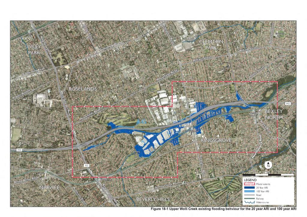
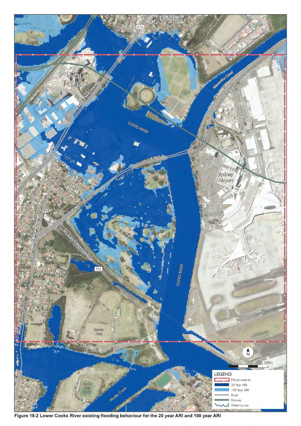
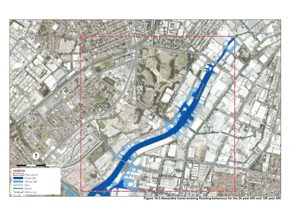
2 Flooding impact assessments Flooding impact assessments have been undertaken for localised and mainstream flooding for construction and operation of the project. Localised flooding occurs when components of the drainage system are undersized or blocked and cannot accommodate the incoming overland surface flows, resulting in the flooding of a localised area. Mainstream flooding refers to the flooding of land when water overflows the natural or artificial banks of a water body. The flooding impact assessment included: Identification of the flooding assessment study area. The relevant study area for flooding impacts includes: The upper Wolli Creek extent. This area is located within the Upper Wolli Creek Floodplain and between King Georges Road, Kingsgrove in the west, Illoura Park, Earlwood in the east, Poole Street, Kingsgrove in the north and the East Hills railway line, Beverly Hills to the south. This section of the study area, including its existing flooding behaviour, is shown on Figure 18-1 The lower Cooks River and Alexandra Canal extent. This area is located within the Lower Cooks River Floodplain and between Banksia in the south west and Wolli Creek to the northwest, and to just west of Sydney Airport in the east, for the Cooks River extent. For the Alexandra Canal extent, the study area includes the area from Mascot in the south to just north of Sydney Park Road, between St Peters and Alexandria from west to east. These sections of the study area, including existing flooding behaviour, is shown on Figure 18-2 and Figure 18-3 respectively A qualitative assessment of flooding during construction, using the existing flood behaviour and drainage infrastructure, for: Localised flooding impacts relevant to the surface works, construction compounds and other structures such as noise barriers Mainstream flooding impacts on the construction process and an assessment of the potential for construction activities to impact mainstream flooding behaviour and adversely affect inundation patterns for nearby properties A qualitative assessment of flooding during operation for localised flooding. The impacts of the project on localised flooding and drainage during operation of the project were made based on the connection of new and upgraded drainage systems to existing local drainage networks. Details of the existing networks were sought from the various authorities that own and maintain these networks, typically local councils and Sydney Water, and where available historical information about existing localised flooding issues were gathered A quantitative assessment of the potential mainstream flooding impacts during operation in upper Wolli Creek, lower Cooks River and Alexandra Canal. The assessment methodology for the quantitative flooding assessment included: Development of a flood model and characterisation of the existing flood behaviour and drainage infrastructure within the flooding assessment study area. The frequency with which a flood event of a certain size occurs is generally described in terms of its average recurrence interval (ARI). For example, for a flood having a 20 year ARI, there would be floods of equal or greater magnitude once in 20 years on average. Flooding behaviour in the flooding assessment study area was defined for the 20 year ARI flood, 100 year ARI flood and probable maximum flood (PMF). The PMF is the largest flood that could conceivably occur at a particular location. The PMF is defined as the upper limiting value of floods that could reasonably be expected to occur. The 200 year ARI flood was also modelled and is contained in the Technical working paper: Flooding (Appendix P). The following flood models were used in the assessment: RAFTS and DRAINS rainfall-runoff modelling software packages were used to generate design discharge hydrographs for input into the hydraulic models WestConnex New M5 18-2
3 TUFLOW two-dimensional (in plan) hydraulic modelling software was used to define flooding patterns in the study area. The structure of the upper Wolli Creek and lower Cooks River TUFLOW models was adjusted to incorporate details of the project HEC-RAS hydraulic modelling software was used to define the upper envelope of flooding in the vicinity of Bexley Road in the upper Wolli Creek floodplain Assessment of the impacts that the operation of the project would have on flooding behaviour during the 20 year ARI flood, 100 year ARI flood and PMF. The future development potential of flood affected land outside the project corridor for residential (and by default commercial and industrial type development) and critical / vulnerable infrastructure was also considered Assessment of the impacts of flooding on the project during the 20 year ARI flood, 100 year ARI flood and PMF Assessment of the impacts a particle blockage (ie the accumulation of debris) of major hydraulic structures would have on flooding behaviour during operation of the project Assessment of the impact future climate change would have on flooding behaviour during operation of the project Identification of appropriate management and safeguard measures to minimise and manage flooding impacts. The 20 year ARI flood and 100 year ARI flood were targeted in the flooding assessment because the: 20 year ARI flood provides a frequent flood event 20 year ARI flood is relevant to construction due to the duration and temporary nature of the construction works. The likelihood of a 100 year ARI event or a PMF occurring during the construction of the project is low 100 year ARI flood is considered the standard flooding planning level during operation. The Floodplain Development Manual requires land use planning to consider the 100 year ARI flood for residential development (and by default commercial and industrial type development). Further details of the assessment of localised flooding impacts during construction and operation, and mainstream flooding impacts during construction are presented in the Technical working paper: Surface water (Appendix N). The assessment of mainstream flooding impacts during operation is presented in Technical working paper: Flooding (Appendix P) Existing environment A general description of the geomorphology and water quality of the existing catchment and watercourse environments is provided in Chapter 16 (Soils and water quality). This section outlines: Existing drainage infrastructure and surface water management infrastructure of the flooding assessment study area The existing flood behaviour of the flooding assessment study area Existing drainage infrastructure The components of the project would include western surface works, Bexley surface works, Arncliffe surface works and St Peters interchange and local road upgrade surface works areas. Within these areas surface water is currently conveyed as overland flow and is collected in established stormwater networks by a combination of stormwater infrastructure elements. These include lined and unlined drainage channels, kerb and gutter networks, and dish drains, all feeding into a well-developed subsurface pit and pipe network. Drainage infrastructure in the area is owned and operated by local councils and Sydney Water. WestConnex New M5 18-3
4 The existing systems were designed to accommodate the ten year ARI rainfall event, but more likely exceed capacity at around the five year ARI rainfall event. Local flooding usually occurs once the design capacity is exceeded in limited overland flow paths, and where limited downstream inlet capacity exists, resulting in rising water levels. Table 18-2 summarises key aspects of the existing drainage systems of the sub-catchments relevant to the project. Table 18-2 Existing drainage systems Catchment Project area Existing drainage systems Wolli Creek subcatchment Western surface works, Kingsgrove Road surface works and Bexley Road surface works The upper Wolli Creek catchment is completely urbanised with a drainage system comprising of extensive pit and pipe networks. Runoff from the western surface works area and Bexley Road surface works area is conveyed as overland flow that currently flows into the M5 East Motorway drainage system. There is an open channel section of Wolli Creek between Kingsgrove Road and Bexley Road, as well as transverse drainage lines which convey runoff into Wolli Creek from areas north of the M5 East Motorway. The transverse drainage system was designed to convey flows up to the 100 year ARI flood magnitude. Several underpasses were also provided between King Georges Road, Bexley Road, and Kingsgrove Road provide additional capacity to convey flows greater than the 100 year ARI flood. Cooks River Arncliffe surface The Cooks River catchment is highly urbanised, with extensive catchment works subsurface pit and pipe networks. The Arncliffe surface works would be located on the Kogarah Golf Course and would drain directly to the Cooks River. Alexandra St Peters Alexandra Canal is a constructed canal, which flows into the Cooks Canal sub- interchange and River near the north-western corner of Sydney Airport. catchment local roads upgrade The canal is owned and operated by Sydney Water as are the major trunk drainage lines discharging into it. Numerous minor drains in the Alexandra Canal sub-catchment are managed by Sydney, Marrickville and Botany Bay Councils. Three channels discharge into Alexandra Canal: Munni Street Stormwater Channel, Sheas Creek Channel and the Botany Road to Doody Street Channel. WestConnex New M5 18-4
5 Catchment Project area Existing drainage systems Eastern St Peters Stormwater runoff is presently generated by a significant Channel interchange and catchment along Campbell Road, as far east as the Princess sub- local roads Highway and drains towards the intersection of Campbell Street / catchment upgrade May Street / Bedwin Road / Unwins Bridge Road Existing flood behaviour An existing piped drainage system at the intersection directs runoff into a pipe, then a box culvert that crosses the adjacent railway line before connecting into the Eastern Channel. In larger storm events, stormwater ponds at the intersection before surcharging into an existing detention basin located at the western end of Camdenville Park. The existing basin cannot drain via gravity, and is dewatered by two pumps that direct stormwater into the above-mentioned box culvert. The intersection of Campbell Street / May Street / Bedwin Road / Unwins Bridge Road is frequently flooded as a result of both limited local inlet capacity in the piped drainage network, as well as limited hydraulic capacity in the downstream trunk drainage system. Development within the study area is typically well established with a high proportion of residential and commercial land use. Land within the surface water study area is also predominantly of an urbanised nature with small pockets of open space, notably along some of the watercourses. Flood risk in the study area has increased since the onset of urbanisation, leading to catchments with a high percentage of impermeable land causing increased runoff during rainfall events. In addition, concrete drainage lines, relatively low levels of infiltration and reduced flood storage capacity within the catchments also results in a quick response to rainfall events. This is particularly significant in small, frequent storm events and results in high peak flows which can cause flooding in parts of the study area. Localised flooding may occur within the area during high intensity rainfall events. It is anticipated that these localised flooding events would be of short duration and would have limited impacts to surrounding receptors and infrastructure. The potential for localised flooding is currently managed through the existing drainage and surface water management infrastructure as described above. As presented in Section 18.1, the quantitative assessment focused on the Lower Cooks River floodplain and Upper Wolli Creek floodplain. The existing flood behaviour for these areas for the 20 and 100 year ARI flood is presented on Figure 18-1 and Figure 18-2 respectively, and discussed in the following sections. A detailed assessment of the Eastern Channel was not undertaken as there would be no major structures constructed in its catchment. The mainline alignment tunnels have not been modelled as flooding impacts would not be expected as a result of subsurface works. The quantitative assessment is described in further detail below. Upper Wolli Creek floodplain Flooding patterns along Wolli Creek and within the flooding assessment study area were assessed for design floods of 20, 100 and 200 year ARI flood, as well as the PMF. WestConnex New M5 18-5
6 The areas around the western surface works that would be inundated as a result of a 20 year ARI flood are shown on Figure 18-1 and include: The section of Wolli Creek running along the southern side of the M5 East Motorway, at Kirrang Street. Floodwater surging the channel at this location flows in an easterly direction, where it does not fully re-enter the channel system until it reaches the Kindilan Street underpass Residential property at 78 Tallawalla Street, on the southern side of the M5 East Motorway, between Kooemba Road and the Kindilan Street underpass. Property fencing would cause increased inundation, resulting in flows diverting into Tallawalla Street Commercial and industrial development located between Beverly Grove Park and Kingsgrove Road, which would be inundated as a result of floodwater surcharging from the southern arm of Wolli Creek. Inundation depths at several properties would exceed one metre. The areas around the western surface works and Bexley Road surface works that would be inundated as a result of a 100 year ARI flood are shown on Figure 18-1 and include: The northern side of the M5 East Motorway, within the Canterbury Golf Course, and from downstream of Beverly Grove Park to east of Arinya Street The southern side of the M5 East Motorway, within properties along the northern side of Tallawalla Street, between Kooemba Road and the Kindilan Street underpass Within the Kindilan Street underpass. Floodwater surcharging the main arm of Wolli Creek at Kingsgrove Road discharges in a northerly direction where it initially ponds beneath the M5 East Motorway underpass before discharging in an easterly direction along the northern side of the elevated M5 East Motorway The commercial and industrial development located between Beverly Grove Park and Kingsgrove Road, and extending along the northern side of Commercial Road, which would be inundated as a result of floodwater surcharging the from the southern arm of Wolli Creek. Inundation depths at several properties would exceed one metre. The areas around the western surface works and Bexley Road surface works that would be inundated as a result of a PMF are: Areas along the northern side of the M5 East Motorway in the vicinity of Canterbury Golf Course, and to the east and west of Kingsgrove Road, which would experience major ponding of floodwaters during a PMF event Properties adjacent to the Wolli Creek canal between King Georges Road and Bexley Road, with major ponding extending along the southern side of the M5 East Motorway between Kooemba Road and Bexley Road. WestConnex New M5 18-6
7
8 (blank page) WestConnex New M5 18-8
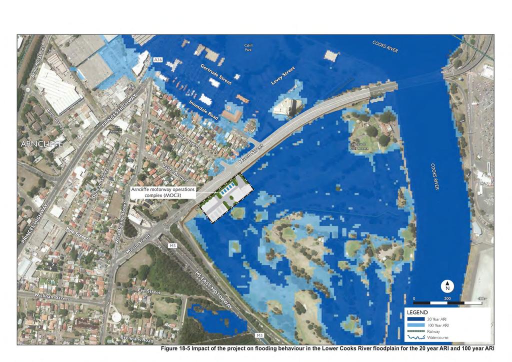
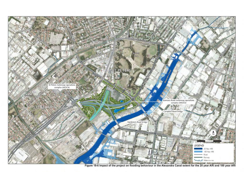
9 Lower Cooks River floodplain The present day flooding patterns along within the Lower Cooks River floodplain within the flooding assessment study area were assessed for design floods of 20, 100 and 200 year ARI, as well as the PMF. The areas within the Lower Cooks River floodplain that would be inundated as a result of a 20 year ARI flood are shown in Figure 18-2 and include: Cahill Park, on the eastern bank of the Cooks River, and adjacent properties Gough Whitlam Park and Mackey Park, to the north of the confluence between Wolli Creek and the Cooks River Kogarah Golf Course Barton Park South Lance Studdert Reserve Properties around Lynwen Crescent, Banksia, and northwards towards Spring Street, Banksia Properties along William Street, Rockdale. During a 100 year ARI flood, the magnitude of flooding at the areas inundated during the 20 year ARI flood would increase, with additional flooding occurring in some adjacent areas. In the case of the PMF event, the Kogarah Golf Course would be inundated to depths exceeding two metres, with the peak flood level along its common boundary with Marsh Street reaching about 4.4 metres AHD. Alexandra Canal flood extent The present day flooding patterns along Alexandra Canal were assessed for design floods of 20, 100 and 200 year ARI flood, as well as the PMF. The areas along Alexandra Canal that would be inundated as a result of a 20 year ARI flood are shown in Figure 18-3 and include: Industrial areas south of Huntley Road, immediately upstream of where Sheas Creek becomes Alexandra Canal Industrial areas upstream of Campbell Road, St Peters Industrial areas along the western extent of Coward Street, and between Coward Street, Mascot and Alexandra Canal Downstream of the railway line, between Alexandra Canal and Swamp Road. During the 100 year ARI flood, the main areas of additional flooding occur within Sydney Airport, and eastwards along Coward Street and Ricketty Street, Mascot. The PMF would cause flooding along the length of Alexandra Canal, extending beyond Kent Street, Mascot and up to the Princes Highway, St Peters. The PMF would also cause flooding within the Alexandria Landfill site. WestConnex New M5 18-9
10 (blank page) WestConnex New M
11
12 (blank page) WestConnex New M
13
14 (blank page) WestConnex New M
15 18.3 Assessment of potential impacts Construction works and operational infrastructure have the potential to change flood behaviour and impact on the surrounding environment. In addition, flooding has the potential to impact on areas within and near construction sites and operational facilities (ie potential inundation of project sites). An assessment of the flood risks to the project and the surrounding environment, along with development of appropriate mitigation measures, has been carried out in accordance with the Floodplain Development Manual (Department of Infrastructure, Planning and Natural Resources, 2005), the requirements of relevant environmental approvals and industry guidelines Construction During construction, flooding and drainage impacts could result in localised and mainstream flooding. The potential impacts are considered further below. Localised flooding All construction works and facilities would have the potential to impact local overland flows and existing minor drainage paths through the disruption of existing flow mechanisms, both of constructed drainage systems or those of overland flow paths. Additionally, flooding during construction of the project could impact areas within and near construction sites (potential inundation of construction sites). Existing drainage and surface water management infrastructure is identified in Table Potential localised flood-related impacts during the construction phase of the project include: Interruption of overland flow paths by installation of temporary construction ancillary facilities Blocking of drainage networks through increased sedimentation of surface water Damage to construction plant or machinery caused by inundation from flood waters Increased flooding of adjacent areas due to temporary loss of floodplain storage or conveyance of floodwaters Disruption to existing drainage lines during decommissioning, upgrade or replacement of drainage pits and pipes, resulting in localised flooding upstream An increase in runoff volumes, peak flows and/or time of concentration following rainfall events due to an increase in impermeable surfaces (ie construction compounds) Flow of water into the tunnel construction access points Localised areas of flooding and scour from the diversion of drainage lines The interruption or diversion of existing flood routes from the location of bunding or spoil within construction compound, resulting in a reduction of flood storage and an increased flood risk to adjacent areas Diversion of flow away from designed drainage structures and into new receiving areas, through the removal of existing pavement Increased flow rates and volumes in watercourses due to the discharge of treated water from the construction water treatment plants. These potential impacts would be relatively minor and would be effectively managed through the implementation of mitigation and management measures, as detailed in Section Further, the potential impacts would be considered during the detailed design phase to ensure that appropriate flood management and flood protection measures are included in the design of the project. For further information refer to Section of the Technical working paper: Surface water (Appendix N). Expected changes to flow rates and volumes would be managed through the control of discharge flow rates from the construction water treatment plants and standard construction management measures. Erosion and sediment controls would direct water away from the tunnel construction access points. Despite this, there remains a low potential for water to flow into the tunnel during high rainfall events. WestConnex New M
16 During construction planning, an emergency response plan would be developed including the evacuation of the tunnel of construction personnel based on certain heavy rainfall events. Mainstream flooding The potential for mainstream flooding to affect the construction process has been assessed, as well as the potential for construction activities to impact flooding behaviour at any nearby properties. Details of potential flooding impacts to construction compounds are provided in Table Potential construction flooding impacts of a 20 year ARI flood have been assessed and are considered appropriate due to the duration of the construction works. The likelihood of a 100 year ARI flood or a PMF occurring during the construction of the project is low, and design of flood mitigation and management measures for these events during construction would not been reasonable. Potential mainstream flooding impacts are generally minor in nature and readily mitigated by managing specific detailed design aspects of the construction compound and site planning to better suit identified flooding conditions and avoid the potential for off-site flooding impacts. Mitigation measures that would be employed are outlined in Section Potential flooding during tunnelling excavation Tunnel boring and cut and cover excavation would occur through temporary shafts at a number of construction compounds and the tunnel portals. Ingress of floodwater into the shafts or portals would pose significant risk to personal safety to those working in the tunnel. Tunnelling excavation works would occur at the following compounds: Kingsgrove North construction compound (C1) Commercial Road construction compound (C3) Bexley Road North construction compound (C4) Bexley Road South construction compound (C5) Arncliffe construction compound (C7) Canal Road construction compound (C8). Protection such as bunding would be provided to ensure floodwaters do not enter shafts or portals. A detailed risk assessment would be undertaken to inform the flood protection measures put in place, prior to construction. The flood immunity that would be adopted would take into consideration the duration of construction, magnitude of inflows, including local overland flows, and potential risks. The flood mitigation measures adopted to protect shafts and portals would be designed in a way that would not worsen flooding on adjacent property. Flood management plans would be developed as part of the Construction Environmental Management Plan (CEMP) prior to construction to guide the design of compounds so as to minimise impacts of flooding. WestConnex New M
17 Table 18-3 Potential construction flooding impacts Project component Existing flooding conditions Potential impacts of activities for 20 year ARI event Western surface works Kingsgrove North construction compound (C1) Kingsgrove South construction compound (C2) Commercial Road construction compound (C3) Bexley Road surface works Bexley Road North construction compound (C4) The construction compound would be located outside of the 20 year ARI flood extent but partially within the 100 year ARI flood extent. The 100 year ARI flood extent would be predominantly confined to the construction compound car park and laydown area. The tunnel dive shaft would be located outside of the 20 year ARI flood, 100 year ARI flood and PMF extents. The construction compound would be located marginally within the 20 year and 100 year ARI flood extents along areas of the construction compound bordering Wolli Creek. Due to the local topography, the 20 and 100 year ARI flood extents within the compound boundaries are similar. The construction compound would be located completely within the 20 year ARI flood, 100 year ARI flood and PMF extent (including tunnel dive shaft). The construction compound would be located completely within the 20 year and 100 year ARI flood extents. None anticipated as the site would only be partially within the 100 year ARI flood extent. None anticipated as the 20 year ARI flood extent would not extend into the construction compound beyond inundating the fence/ boundary. All activities would be impacted by a 20 year ARI flood event. The acoustic shed and flood protection measures to protect against ingress of floodwaters into the compound would have the potential to impact flood conveyance and/or storage. Temporary compensatory drainage works would be implemented to minimise impacts adjacent to existing development as far as practicable. All activities would be impacted by a 20 year ARI flood event. The acoustic shed and flood protection measures to protect against ingress of floodwaters into the compound would have the potential to impact flood conveyance and/or storage. However these impacts are unlikely to impact existing development. WestConnex New M
18 Project component Existing flooding conditions Potential impacts of activities for 20 year ARI event Bexley Road South construction compound (C5) Bexley Road East construction compound (C6) Arncliffe surface works Arncliffe construction compound (C7) The construction compound would be located partially within the 20 year and 100 year ARI flood extents. The boundaries of the 20 year and 100 year ARI flood extents are similar at this location. The compound (including tunnel dive shafts) would be located within the PMF flood extent. The construction compound would be located completely outside of the 100 year ARI flood extent. The construction compound would be located predominantly within the 20 year and 100 year ARI flood extents. The acoustic shed and flood protection measures to protect against ingress of floodwaters into the compound would have the potential to impact flood conveyance and/or storage. However these impacts are unlikely to impact existing development. None anticipated due to its location outside of the 100 year ARI flood. The majority of activities would be impacted by flooding although the stockpile and acoustic shed are outside of 20 year ARI. St Peters interchange and local roads upgrade Canal Road construction compound (C8) Campbell Road construction compound (C9) Landfill Closure construction compound (C10) Burrows Road construction compound (C11) Alexandra Bridge construction compound (C12) The construction compound would be located completely outside of the 100 year ARI flood extent. The construction compound would be located completely outside of the 100 year ARI flood extent. The construction compound would be located completely outside of the PMF flood extent. The construction compound would be located completely outside of the 100 year ARI flood extent. The construction compound would be located partially within the 20 year ARI flood extent and completely within the 100 year ARI flood extent. Flood protection measures to protect against ingress of floodwaters into the compound would have the potential to impact flood conveyance and/or storage. Design of these measures will give consideration to minimising adverse flooding impacts adjacent to existing development north of Marsh Street as far as practicable. None anticipated due to its location outside of the 100 year ARI flood extent. None anticipated due to its location outside of the 100 year ARI flood extent. None anticipated due to its location outside of the 100 year ARI flood extent. None anticipated due to its location outside of the 100 year ARI flood extent. Potential minor impacts to activities on the immediate banks of Canal. No measureable impact on flood storage or conveyance anticipated during a flood event. WestConnex New M
19 Project component Existing flooding conditions Potential impacts of activities for 20 year ARI event Gardeners Bridge construction compound (C13) Sydney Park construction compound (C14) The construction compound would be only marginally affected by the 20 year ARI flood extent. It would be partially within 100 year ARI flood extent. The construction compound would be located completely above the PMF flood extent. None anticipated as the site would be only marginally within the 20 year ARI and 100 year ARI flood extent. None anticipated as the site would be outside of the PMF extent. WestConnex New M
20 Operation During operation, flooding and drainage impacts could include the following: Impacts from the operational water treatment plant Localised flooding Mainstream flooding. The main objective for the drainage design of the project is to provide the required flood immunity for the project and to minimise changes to the existing flood behaviour of land around operational infrastructure. Operational water treatment plant As the project tunnels would be drained, there would be ongoing groundwater inflow into the tunnels (refer to Chapter 19 Groundwater). This would require the ongoing capture, treatment and discharge of groundwater during the operation of the project. Other sources of wastewater within the project tunnels would include stormwater entering the tunnels via the portals, deluge water, washdown water and hydrant water. The discharge of treated water from the operational water treatment plant has the potential to increase flow rates and volumes in watercourses. Details of the operational water treatment plant are provided in Chapter 16 (Soils and water quality) and Chapter 24 (Construction resource use and waste minimisation). The tunnel drainage system would flow to one sump at the tunnel low point, with a capacity of around 412 cubic metres before being pumped to the operational water treatment plant. The capacity of the sump has been designed to include 50 cubic metres (50,000 litres) of spare capacity to capture accidental operational hydrocarbon or other spillage within the tunnel (for example, in the case of an accident resulting in release of fuel from vehicles). Groundwater leakage from the tunnel walls and floors would also be transferred to the tunnel sump. After being pumped to the operational water treatment plant, the water would be treated and discharged to the Cooks River. The discharge flow rate would be controlled to manage changes to flow rates and volumes. Localised flooding and proposed drainage infrastructure Potential localised flood-related impacts during operation include: Blockage or temporary diversions of drainage infrastructure, which may result in localised flooding Altered catchments from new and widened roads New and altered drainage infrastructure, which may not have sufficient capacity to accommodate increased inflow rates. Existing drainage and surface water management infrastructure as identified in Table 18-2 would continue to manage surface drainage and potential flooding. Additional upgrades would be carried out where parts of the drainage infrastructure would be impacted by the project and/ or would require relocation. The drainage structures incorporated into the project would include existing drainage infrastructure around the interchanges, tie-in and integration works, and operational ancillary facilities which would be augmented to meet additional capacity requirements associated with increased impervious areas. Appropriate protection would be provided downstream of relevant drainage infrastructure to prevent adverse impacts on bed and bank stability, and to protect the existing water quality of downstream watercourses. These drainage systems would be designed and implemented to minimise potential impacts on receiving watercourse. Table 18-4 provides an overview of the proposed drainage systems as part of the project. WestConnex New M
21 Table 18-4 Project drainage systems Project area Project component Proposed drainage upgrades Western surface works and Bexley Road surface works Arncliffe surface works St Peters interchange Western portals, tolling infrastructure, Kingsgrove and Bexley Road motorway operations complexes (MOC1 and MOC2) Arncliffe motorway operations complex (MOC3) St Peters and Bedwin motorway operation complexes (MOC4 and MOC5) New and / or upgraded drainage infrastructure to be provided as part of the western surface works and Bexley Road surface works includes: New operational drainage infrastructure connecting existing stormwater infrastructure to a concrete channel at Kirrang Street A new basin to capture and treat runoff, including one within the western surface works area, one at the surface near the southern extension caverns and one near the corner of Burrows Road and Campbell Road New and upgraded culverts, including: A new box culvert to connect existing stormwater pipes to a concrete channel at Kirrang Street, Beverly Hills (near the western end of the western surface works areas) underneath the existing shared pedestrian and cycle path Extension of the two existing culverts at Kooemba Road, Beverly Hills (near the western end of the western surface works areas), by around 30 metres to accommodate the widening of the motorway at this point. New and / or upgraded drainage infrastructure as part of the Arncliffe surface works would be confirmed during detailed design. New pipe connections would be installed where the existing transverse drainage requires upgrade and/ or relocation. This would include new and upgraded trunk and transverse drainage infrastructure upgrades. A new basin would also be established to capture and treat runoff at the surface near the southern extension caverns. Pavement drainage would be designed for the 10 year ARI flood, with pits spaced to limit flow width to shoulders where provided or one metre into the adjoining traffic lane where no shoulder is provided. The project would discharge into the existing Wolli Creek concrete lined channel via transverse drainage upgrades. New and / or upgraded drainage infrastructure to be provided as part of the St Peters interchange works includes: A new basin to capture and treat runoff near the corner of Burrows Road and Campbell Road Two water quality basins within the St Peters interchange to capture, store and treat surface water runoff Upgrades to the existing detention basin in Camdenville Park to ensure downstream peak flow rates are not increased for events up to and including 100 year ARI flood. The required increase WestConnex New M
22 Project area Project component Proposed drainage upgrades Local roads upgrades Local road upgrades affected by flooding in storage capacity would be confirmed during detailed design Installation of new hydrodynamic oil and grit separators within the western surface works area, St Peters interchange and local road upgrade surface works area to capture and treat surface water runoff at locations where construction of a surface water basin is impractical and/ or due to site location constraints restricting the construction of a basin Upgrades to the existing drainage infrastructure that serves local surface roads (within the St Peters interchange and local road upgrade surface works areas), including connection to the existing piped drainage network and/ or provision of a new drainage discharge point at Alexandra Canal. New pipe connections would be installed where the existing transverse drainage requires upgrade and / or relocation. The upgrades and replacements of drainage infrastructure would respond to altered and increased catchments attributed to newly paved areas. Due to the urbanised nature and relatively flat topography of the area, the majority of new pipes would connect into existing networks prior to discharging as surface water. The intersection of Campbell Road and Burrows Road has been identified as having the potential to flood relatively frequently. A culvert would be constructed under Burrows Road to the south of Campbell Road to convey flows to Alexandra Canal. This would be in addition to other smaller transverse drainage pipes. The Munni Street Stormwater Channel would be crossed by a widened bridge structure to allow for the widening of Euston Road. The detailed design of the bridge and roadworks would give consideration to minimising flooding impacts on adjacent property whilst achieving the geometric design requirements for the road. This would be informed by flood analysis with the benefit of detailed survey information relating to existing stormwater infrastructure, ground levels and existing development. The project would include two new discharge outlets into Alexandra Canal: An open channel discharging immediately to the south-west of the new Campbell Road bridge A piped discharge outlet immediately to the southeast of new Campbell Road bridge. WestConnex New M
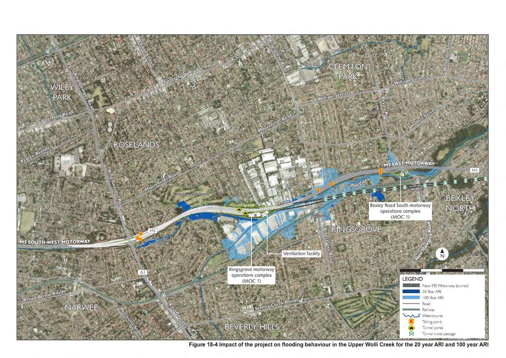
23 Mainstream flooding Potential mainstream flood-related impacts during operation include: An increase in runoff volumes, peak flows and / or time of concentration following rainfall events due to an increase in impermeable surfaces (ie operational infrastructure) An increased flood risk in adjacent areas due to the location of operational infrastructure, which has the potential to interrupt or divert existing flood routes and also reduce flood storage. Mainstream flooding during operation was assessed by modelling the impacts of operational infrastructure and future climate change on flood behaviour. Model scenarios included: The 20 year ARI flood, 100 year ARI flood and PMF events The impact of a 10 per cent increase in rainfall intensity during a 100 year ARI flood The impact of a 0.4 metre rise in sea levels by 2015 on a 100 year ARI flood and PMF. Potential mainstream flooding impacts are generally minor in nature and readily mitigated by managing specific detailed design aspects and site planning to suit identified flooding conditions and avoid the potential for off-site flooding impacts. A summary of the key flood assessment findings for each project area is provided below and mitigation measures that would be employed are outlined in Section Technical working paper: Flooding (Appendix P) provides additional details of flood modelling and includes figures showing the predicted impact for each of the modelling scenarios. Impact of the project on flood behaviour The impact of the project on existing flooding behaviour on the upper Wolli Creek floodplain for design floods of 20, 100 and 200 year ARI flood, as well as the PMF were modelled (refer to Figure 18-4). The key findings of this assessment are as follows: The widening of the M5 East Motorway would result in an increase in peak flood levels along the northern side of the M5 East Motorway for floods up to a 100 year ARI. However, the resulting impacts would be confined to the M5 East Motorway corridor and the Canterbury Golf Course The project would not increase peak flood levels in existing residential development areas for all floods up to the 100 year ARI flood The constriction imposed on flow by widening the M5 East Motorway would lead to an increase in peak PMF levels from around 0.45 metres to about 0.95 metres in the vicinity of the Canterbury Golf Course. The effects of the road widening on peak PMF levels would extend into seven residential properties that are located to the west of the Canterbury Golf Course in Elouera Street and Kirrang Street, Beverly Hills. Flooding in the seven properties would generally be of a ponding nature, with flow velocities shown to be less than about 0.1 metres per second during a PMF event. Inundation of previously flood free land would generally be confined to the landscaped portion of five of the seven properties. However, floodwater would inundate land bordering the dwellings in Nos. 50 and 52 Elouera Street, Beverley Hills. While floor level survey would be required to determine whether the project would result in the above-floor inundation of these two dwellings, inspection of the LiDAR survey data shows that ground levels in the majority of No. 50 and in the south-west corner of No. 52 Elouera Street lie above the PMF level, indicating that evacuation would still be possible from the two properties by foot during an event of this magnitude. No measures are proposed to mitigate the impact of the project on these properties, as all properties would continue to lie above the residential flood planning level which in the Canterbury LGA is equal to the 100 year ARI event flood plus an allowance of 0.5 metres for freeboard The constriction imposed by the widening of the M5 East Motorway would lead to a reduction in peak PMF flood levels on the northern side of the M5 East Motorway in the vicinity of Beverly Grove Park and on the southern side of the M5 East Motorway in the vicinity of Tallawalla Street The minor change in the distribution of flow in the drainage system would result in a minor increase in peak 100 year ARI flood levels in two industrial / commercial properties located on the WestConnex New M
24 southern side of the M5 East Motorway opposite the outlet of two transverse drainage structures. The maximum increase in peak 100 year ARI flood levels for both properties would be about 20 millimetres The realignment of a transverse drainage structure along the M5 East Motorway between Wolli Creek and Garema Circuit would not result in a redistribution of flow in the drainage system for all floods up to the PMF The project would not result in more frequent inundations of property or the local road network over the full range of flood events The project would not increase the duration of flooding for all events up to the PMF The project would not impact existing evacuation routes. Based on the above findings, the project would not impact the development potential of existing properties for residential, commercial and industrial purposes. However the modelled increase in peak PMF levels along the northern side of the M5 East Motorway, in the vicinity of Canterbury Golf Course, would constrain development in at least one residential property located at Elouera Street, Beverly Hills. The development would be constrained if, for example, the owner wished to augment the existing dwelling to incorporate a more sensitive land use such as child or aged-care facility (note that the existing land zoning is R3 medium density residential under the Canterbury LEP 2012 which permits child care centres and respite day care centres with development consent). WestConnex New M
25
26 (blank page) WestConnex New M
27 The impacts of the project on existing flooding behaviour were modelled for the lower Cooks River floodplain and along Alexandra Canal for design floods of 20, 100 and 200 year ARI floods, as well as the PMF (refer to Figure 18-5 and Figure 18-6). The key findings of this assessment are as follows: The loss of about 12,000 cubic metres of floodplain storage associated with the construction of the Arncliffe motorway operations complex (MOC3) (based on a worst case disturbance footprint) would result in an increase in peak 100 year ARI flood levels in seven residential properties located on the northern (upstream) side of Marsh Street. The maximum increase in peak flood levels at these properties would be about 10 millimetres. A floor level survey would be required at the abovementioned properties to determine whether the project would result in the above-floor inundation of these properties due to flood levels. The potential impacts would be confirmed based on the detailed design of the Arncliffe motorway operations complex (MOC3). The construction of the two new road bridges across Alexandra Canal would generally not impact peak flood levels for events up to a 100 year ARI flood. However, the raising of the Campbell Road / Burrows Road intersection would impact local flooding patterns, leading to an increase in peak 100 year ARI flood levels by about 30 millimetres at two commercial / industrial properties, as well as in a recently upgraded section of TransGrid s Beaconsfield West Substation The loss of floodplain storage resulting from the construction of both the Arncliffe motorway operations complex (MOC3), the St Peters interchange and local road upgrades in combination with the constrictive effects imposed by the two new road bridges across Alexandra Canal would result in an increase in peak PMF flood levels across a large portion of the lower Cooks River floodplain. While increases in peak PMF levels would generally be in the range 10 to 50 millimetres, increases of greater than 100 millimetres would occur in an existing commercial / industrial development located on the western overbank of the Alexandra Canal immediately upstream of the Campbell Road bridge The resulting increase in peak PMF flood levels would not translate into a significant increase in the extent of flood prone land The flood risk at Sydney Airport would not be increased given the minor impact the project would have on flooding behaviour The project would not alter the distribution of flows on the lower Cooks River floodplain Peak flood levels would generally be increased in the range of 10 to 50 millimetres on the lower Cooks River floodplain, with greater increases to occur immediately upstream of the new Campbell Road bridge (generally in the range of 20 to 200 millimetres) and on the northern side of Marsh Street opposite the Arncliffe motorway operations control centre (MOC3) Additional pavement areas from the widening of Campbell Street and adjoining streets would cause a large increase in runoff within the catchment draining to Camdenville Park. The project would include improvements to the hydraulic standard of the drainage system servicing the roads that would be upgraded. This increase in runoff would be offset through provision of additional detention storage within and adjacent to Camdenville Park. This would limit increases in peak flow rates discharged to the downstream trunk drainage system. However the proposed drainage strategy would be determined during detailed design and would be based on not increasing flows into the Eastern Channel for all events up to and including the 100 year ARI flood. An option to achieve this would include the following key elements: Enlargement of the existing detention basin through excavation to lower existing ground levels and the use of retaining walls adjacent to the upgraded sections of Bedwin Road and May Street. As this is a contaminated site, excavation would be planned accordingly. Based on preliminary analysis, the existing storage volume of around 6000 cubic metres would need to be increased to around 17,000 cubic metres to limit peak flow rates downstream of the basin to no greater than occurs under present day conditions for events up to and including the 100 year ARI flood. This required increase in capacity would be confirmed during detailed design Upgrade of the existing discharge system and associated infrastructure including rising mains to suit the enlarged basin, to renew those assets while maintaining the existing pumping capacity WestConnex New M
28 Construction of supplementary underground detention storage along the south-western side of Bedwin Road, within the space created by realignment of this road. This would be hydraulically connected to the upgraded basin, with discharge via an outlet control structure to the existing box culvert beneath the rail line. The need for this supplementary storage would be confirmed during detailed design. The project would not result in more frequent inundation of property or the local road network over the full range of flood events The project would not increase the duration of flooding for all events up to the PMF The project would not impact existing evacuation routes. Based on the above findings, the project could potentially increase the frequency and depth of abovefloor inundation in a number of residential properties that are located along the northern (upstream) side of Marsh Street opposite the Arncliffe motorway operations complex. Consultation with TransGrid in relation to the Beaconsfield West Substation has confirmed that a conservative design approach was adopted in the recent upgrade of the substation. This included positioning critical infrastructure above about six metres AHD, and setting all transformer switch bays and reactive plant at ground level (about two metres AHD). Further design development would be undertaken during detailed design in order to mitigate the impact of the project on flooding conditions in the TransGrid site. This would include further refinement of design of the relief drain, as well as the western approach to the new Campbell Street bridge. WestConnex New M
29
30 (blank page) WestConnex New M
31
An indicative program for works to be conducted within the Sydney Park construction compound is provided in Table 6-20.
 The land required for the Sydney Park construction compound would be used temporarily throughout construction only. The construction compound site would be rehabilitated at the completion of construction,
(blank page) WestConnex New M Roads and Maritime Services Environmental impact statement
 WestConnex New M Roads and Maritime Services Environmental impact statement") (blank page) WestConnex New M5 5-122 (blank page) WestConnex New M5 5-124 5.8.1 Operational management control systems and incident and emergency response The project has been designed to include control
(blank page) WestConnex New M5 5-122 (blank page) WestConnex New M5 5-124 5.8.1 Operational management control systems and incident and emergency response The project has been designed to include control
5.0 The project. 5.1 Construction
 59 5.0 The project This chapter provides a summary of the potential impacts of the project during and operation. A full description of the project is provided in Chapter 5 and Chapter 6 of the EIS. 5.1
SEARs project justification and conclusion
 31 Project justification and conclusion This chapter presents a justification for the project and a conclusion to the environmental impact statement (EIS). The justification is based on the strategic need
SEARs climate change risk and adaptation
 25 Climate change risk and adaptation The NSW Government has acknowledged that, despite efforts to reduce greenhouse gas emissions, some climate change is now inevitable. The Government aims to minimise
Construction Contaminated Land Management Plan
 Construction Contaminated Land Project Name: WestConnex New M5 Project number: 15.7020.2597 Document number: M5N-ES-PLN-PWD-0033 Revision date: 18 June 2018 Revision: 03 Document Approval Rev. Date Prepared
Construction Contaminated Land Management Plan
 Construction Contaminated Land Project Name: WestConnex New M5 Project number: 15.7020.2597 Document number: M5N-ES-PLN-PWD-0033 Revision date: 1 June 2016 Revision: 01 Document Approval Rev. Date Prepared
Roads and Maritime Services
 November 2015 Prepared for Prepared by AECOM Australia The concepts and information contained in this document are the property of Roads and Maritime Services. You must not reproduce any part of this document
Refer to Chapter 3.0 (Description of Development) for a detailed site and development description.
 for a detailed site and development description.") 7. WATER: HYDROGEOLOGY & HYDROLOGY 7.1 Introduction This chapter of the EIAR comprises of an assessment of the likely impact of the proposed development on the surrounding surface water and hydrogeological
7. WATER: HYDROGEOLOGY & HYDROLOGY 7.1 Introduction This chapter of the EIAR comprises of an assessment of the likely impact of the proposed development on the surrounding surface water and hydrogeological
E. STORMWATER MANAGEMENT
 E. STORMWATER MANAGEMENT 1. Existing Conditions The Project Site is located within the Lower Hudson Watershed. According to the New York State Department of Environmental Conservation (NYSDEC), Lower Hudson
29 Environmental risk analysis
 29 Environmental risk analysis A detailed environmental risk analysis was conducted as part of this environmental impact statement (EIS). This chapter outlines the environmental risk analysis process and
DRAINAGE REVIEW: Berwick Health and Education Precinct. for. Victorian Planning Authority
 DRAINAGE REVIEW: Berwick Health and Education Precinct for Victorian Planning Authority April 2017 Document history Revision: Revision no. 03 Author/s Jonathon McLean Approved Jonathon McLean Distribution:
14 NATURAL HAZARDS Background Resource Management Issues
 14 NATURAL HAZARDS 14.1 Background The particular geology, hydrology and topography of the Hutt Valley make Upper Hutt vulnerable to a variety of natural hazards. Earthquakes and flooding are the most
A part of BMT in Energy and Environment Kosciusko Avenue Main Drain Catchment Drainage / Flood Study Draft Report
 A part of BMT in Energy and Environment Kosciusko Avenue Main Drain Catchment Drainage / Flood Study Draft Report R.M7299.003.00.DraftReport January 2011 Kosciusko Avenue Main Drain Catchment Drainage
Gold Coast. Rapid Transit. Hydrology and Hydraulics
 Gold Coast Rapid Transit 19 Hydrology and Hydraulics Contents 1. Introduction 19 1 2. Source Data 19 2 3. Methodology 19 3 3.1 Drainage Upgrades 19 3 3.2 Period of Closure 19 6 4. Description of the Existing
APPENDIX F: DRAINAGE AND STORMWATER MANAGEMENT
 APPENDIX F: DRAINAGE AND STORMWATER MANAGEMENT Downtown Ottawa Transit Tunnel: Tunney s Pasture to Blair Station via a Downtown LRT Tunnel Prepared for: City of Ottawa 110 Laurier Avenue West Ottawa, ON
Temporary Watercourse Crossing: Culverts
 Temporary Watercourse Crossing: Culverts DRAINAGE CONTROL TECHNIQUE Low Gradient Velocity Control Short Term Steep Gradient Channel Lining Medium-Long Term Outlet Control Soil Treatment Permanent Symbol
3.5 Hydrology & Hydraulics
 3.5 Hydrology & Hydraulics 3.5.1 Purpose The purpose of this section is to provide results from the analysis and assessment of the impact of the proposed Carmichael Rail Alignment (Option 11 Revision 1)
SEARs project development and alternatives
 4 Project development and alternatives This chapter describes the alternatives to the project that were considered as part of the development process and explains how and why the project was selected as
Six above ground substations would be constructed for the project. The construction methodology for these facilities would typically involve:
 Electrical substations Six above ground substations would be constructed for the project. The construction methodology for these facilities would typically involve: Excavation, footing and base slab installation
STORM DRAINAGE DESIGN MANUAL
 Appendix I STORM DRAINAGE DESIGN MANUAL by: SUNGATE DESIGN GROUP, P.A. GEN ERAL DESIGN STAN DARDS AN D POLICIES 1. STREET AND LOCAL DRAINAGE Discharge estimates for specified design storms shall be calculated
STORM WATER MANAGEMENT REPORT
 Silvercreek Junction STORM WATER MANAGEMENT REPORT Howitt Creek at the Silvercreek Parkway Site Guelph, Ontario August, 2008 TSH File 22304A-04 August 19, 2008 STORMWATER MANAGEMENT REPORT Howitt Creek
Technical Report Flood Mitigation Strategy
 Technical Report Flood Mitigation Strategy Contract No. 15.7105.1373 Document No. Document Approval Rev Date Prepared by Reviewed by Approved by Remarks C_01 19/05/2016 J. Beck (AEH) L. Segundo T.Dias
Surface Water Guidance for Developers
 Surface Water Guidance for Developers Contents Overview of Sustainable Drainage Systems (SuDS)... 2 Information Required in a Flood Risk Assessment or Drainage Strategy... 3 Outline Planning Applications...
CITY UTILITIES DESIGN STANDARDS MANUAL
 CITY UTILITIES DESIGN STANDARDS MANUAL () September 2017 Page Chapter 1 Acronyms and Definitions 1.01 Purpose 1 1.02 Acronyms 1 1.03 Definitions 3 Chapter 2 Introduction 2.01 Purpose 1 2.02 Applicability
CONSTRUCTION PLAN CHECKLIST
 CONSTRUCTION PLAN CHECKLIST The design engineer is responsible for ensuring that plans submitted for city review are in accordance with this checklist. It is requested that the executed checklist be submitted
UNIVERSITY OF OREGON NORTH CAMPUS CONDITIONAL USE PERMIT PROJECT Draft Conditional Use Permit Stormwater, Sanitary Sewer, and Water Analysis Report
 UNIVERSITY OF OREGON NORTH CAMPUS CONDITIONAL USE PERMIT PROJECT Draft Conditional Use Permit Stormwater, Sanitary Sewer, and Water Analysis Report Prepared for: Cameron McCarthy Landscape Architects LLP
A Stormwater Management Plan and Sediment Control Plan are required for all proposed developments within the City of Richmond.
 Engineering Page 3-1 3.0 STORM DRAINAGE 3.1 GENERAL Good drainage is vital to flat urban areas such as Lulu Island. It is essential that every storm sewer must be designed accurately minimizing conflicts
PART 5D - NATURAL HAZARDS
 CONTENTS...PAGE 5D.1 CONTENT AND STRUCTURE...3 5D.2 RESOURCE MANAGEMENT ISSUES...3 5D.3 RESOURCE MANAGEMENT OBJECTIVE AND POLICIES...4 5D.4 RESOURCE MANAGEMENT STRATEGY...4 5D.5 IMPLEMENTATION...4 5D.6.RULES
Outcomes Summary: Consultation on noise barrier options near Glamis Street, Armitree Street, and Rosebank Avenue, Kingsgrove January 2017
 Outcomes Summary: Consultation on noise barrier options near Glamis Street, Armitree Street, and Rosebank Avenue, Kingsgrove January 2017 Overview In response to public submissions made during the Environmental
Masters Geelong Stormwater Management Plan
 ` Masters Geelong Job Number: CG111748 ABN 47 106 610 913 150 Oxford Street, Collingwood Victoria 3066 Australia Telephone: 03 8415 7777 Facsimile: 03 8415 7788 International: +61 3 8415 7777 victoria@cardno.com.au
LAKE COUNTY HYDROLOGY DESIGN STANDARDS
 LAKE COUNTY HYDROLOGY DESIGN STANDARDS Lake County Department of Public Works Water Resources Division 255 N. Forbes Street Lakeport, CA 95453 (707)263-2341 Adopted June 22, 1999 These Standards provide
SWFWMD RAI No. 1 Comments 8a & 8b Response Appendix G Proposed Drainage Design Criteria
 SWFWMD RAI No. 1 Comments 8a & 8b Response Appendix G Proposed Drainage Design Criteria I-75 from North of Fruitville Road to North of University Parkway FPID No: 201032-4-32-01 & 201277-2-32-01 Manatee
CRYSTAL LAKE FLOODING STUDY EXECUTIVE SUMMARY
 Project #08223 CRYSTAL LAKE FLOODING STUDY EXECUTIVE SUMMARY PREPARED FOR: City of Crystal Lake 100 West Woodstock Street Crystal Lake, Illinois 60014 FEBRUARY 11, 2009 26575 W. COMMERCE DRIVE, SUITE 601,
REPORT Condition D19 Permanent Noise Barriers
 REPORT Condition D19 Permanent Noise Barriers Project Name: WestConnex New M5 Project number: 15.7020.2597 Revision date: 19/08/2016 Revision: 1 Document Approval Rev. Prepared by Reviewed by Recommended
Pakenham East Precinct Structure Plan. Deep Creek Corridor Proposals
 Hydrological and Environmental Engineering Pakenham East Precinct Structure Plan Deep Creek Corridor Proposals 5 October 2014 Report by: Valerie Mag BE Civil (Hons), M Eng Sci Stormy Water Solutions stormywater@optusnet.com.au
Construction Traffic and Access Sub Plan
 Construction Traffic and Access Project Name: WestConnex New M5 Project number: 15.7020.2597 Document number: M5N-ES-PLN-PWD-0004 Revision date: 5/07/2018 Revision: 10 Document Approval Rev. Date Prepared
Environmental Assessment Derry Road and Argentia Road Intersection
 Environmental Assessment Derry Road and Argentia Road Intersection Project 11-4295 City of Mississauga, Region of Peel October 15, 2014 INTRODUCTION Table of Contents Introduction... 2 Description of the
Abstract. Policy Context for Flood Risk Management in NSW. A Frazer 1, D McLuckie 1, J Bucinskas 1, A Toniato 1, G Pelosi 1, P Buchanan 1
 LOCAL OVERLAND FLOODING THE NSW EXPERIENCE A Frazer 1, D McLuckie 1, J Bucinskas 1, A Toniato 1, G Pelosi 1, P Buchanan 1 1 Office of Environment and Heritage, NSW Abstract Local overland flooding describes
Strategic Flood Risk Assessment (SFRA) Level 2
 Level 2") Strategic Flood Risk Assessment (SFRA) Level 2 (Final) South Bucks District Council Capswood Oxford Road Denham UB9 4LH (this page intentionally blank) Level 2 SFRA Background The South Bucks Level 1 SFRA
Strategic Flood Risk Assessment (SFRA) Level 2 (Final) South Bucks District Council Capswood Oxford Road Denham UB9 4LH (this page intentionally blank) Level 2 SFRA Background The South Bucks Level 1 SFRA
E36. Natural hazards and flooding
 E36. Natural hazards and flooding E36.1. Background Auckland is affected by natural hazards including: those that occur frequently such as flooding, coastal erosion (including the effects of sea level
17 Contamination. in the Technical working paper (Contamination)
") 17 Contamination This chapter provides a summary of the Technical working paper: Contamination (Appendix O), which was prepared to inform this environmental impact statement (EIS) and address the Secretary
17 Contamination This chapter provides a summary of the Technical working paper: Contamination (Appendix O), which was prepared to inform this environmental impact statement (EIS) and address the Secretary
Phase II: Proposed (regulated) Impervious in disturbed area (ac) Long Lake Existing Impervious in disturbed area (ac)
 Impervious in disturbed area (ac) Long Lake Existing Impervious in disturbed area (ac)") Permit Application No.: 17-181 Rules: Erosion Control, Wetland Protection, and Waterbody Crossings & Structures Applicant: Hennepin County Received: 4/27/17 Project: CSAH 112 Phase II Complete: 9/5/17
Permit Application No.: 17-181 Rules: Erosion Control, Wetland Protection, and Waterbody Crossings & Structures Applicant: Hennepin County Received: 4/27/17 Project: CSAH 112 Phase II Complete: 9/5/17
Appendix 9 - Engineering Performance Standards
 Appendix 9 - Engineering Performance Standards A9.1 Introduction A9.1.1 This Appendix contains standards that apply to the subdivision of land. It is referred to in the Subdivision Rules for the Living,
acquiring, managing, and disposing of federal lands and facilities;
 2.2.1 HYDROLOGY AND FLOODPLAIN This section discusses and analyzes the surface hydrology and water quality characteristics of the project. The information provided in this section is based on the Preliminary
14 NATURAL HAZARDS Background Resource Management Issues
 14 NATURAL HAZARDS 14.1 Background The particular geology, hydrology and topography of the Hutt Valley make Upper Hutt vulnerable to a variety of natural hazards. Earthquakes and flooding are the most
CHAPTER 3 Environmental Guidelines for WATERCOURSE CROSSINGS GOVERNMENT OF NEWFOUNDLAND AND LABRADOR DEPARTMENT OF ENVIRONMENT AND LABOUR
 GOVERNMENT OF NEWFOUNDLAND AND LABRADOR DEPARTMENT OF ENVIRONMENT AND LABOUR CHAPTER 3 Environmental Guidelines for WATERCOURSE CROSSINGS WATER RESOURCES MANAGEMENT DIVISION Water Investigations Section
Action plans for hotspot locations
 Action plans for hotspot locations Ash Vale North 1. Local evidence indicates the culvert could not discharge during December 2013 because the outlet was blocked on the western side of the railway. Guildford
Rising Sun. Scaffold Hill. Flood Risk Assessment
 Rising Sun Scaffold Hill Flood Risk Assessment August 2010 Contents 1.0 Introduction... 4 2.0 Site Description... 5 3.0 Legislative Framework... 6 4.0 Flood Risk... 10 5.0 Surface Water Drainage... 11
Stage 3: Flood Study Report DRAFT
 hydrol Stage 3: Flood Study Report DRAFT Dee Why South Catchment Flood Study W4961 W4961 Prepared for 29 April 2013 Document Information Prepared for Project Name File Reference R001 Stage 3 Flood Study
FIRM NAME DESIGNER: CHECKER: DATE: FPID #: DESCRIPTION: COUNTY: DRAINAGE DESIGN CHECKLIST. Designers Initials. Checkers Initials.
 I. Drainage Report A. Executive Summary - Brief Overview of Project Drainage Design B. Project Description 1. Existing Conditions 2. Proposed Project Conditions 3. Project Justification Narrative - Basin
This chapter describes the potential hydrological effects of the Project in terms of:
 19. Hydrology Overview The Project will result in changes to existing hydrology from land use changes and from changes to stream morphology. Hydrological and hydraulic modelling has been undertaken to
WestConnex Stage 3 EIS (M4/M5 Link) Submission by Alexandria Residents Action Group (ARAG)
 Submission by Alexandria Residents Action Group (ARAG)") WestConnex Stage 3 EIS (M4/M5 Link) Submission by Alexandria Residents Action Group (ARAG) Summary ARAG strongly objects to the WestConnex M4-M5 Link for the following reasons: There is a lack of strategic
WestConnex Stage 3 EIS (M4/M5 Link) Submission by Alexandria Residents Action Group (ARAG) Summary ARAG strongly objects to the WestConnex M4-M5 Link for the following reasons: There is a lack of strategic
Storm Water Management
 Storm Water Management Policy September 2014 2 Sustainable drainage feature designed to control and manage flows through a series of check dams 3 Document Name: Storm Water Management Controlled Copy No:
DESIGN BULLETIN #16/2003 (Revised July 2007) Drainage Guidelines for Highways Under Provincial Jurisdiction in Urban Areas.
 Drainage Guidelines for Highways Under Provincial Jurisdiction in Urban Areas.") Drainage Guidelines for Highways Under Provincial Jurisdiction in Urban Areas. July 2007 Update to Design Bulletin #16/2003: Added under Design Criteria Culverts of 600mm diameter are commonly used to
Drainage Guidelines for Highways Under Provincial Jurisdiction in Urban Areas. July 2007 Update to Design Bulletin #16/2003: Added under Design Criteria Culverts of 600mm diameter are commonly used to
13. NETWORK UTILITIES
 13. NETWORK UTILITIES Overview The Project directly affects a number of existing network utilities, including electricity transmission and distribution lines, telecommunications, water supply, wastewater
Appendix G Preliminary Hydrology Study
 Appendix G Preliminary Hydrology Study Preliminary Hydrology Study VESTING TTM 72608 Long Beach, CA Prepared for: The Long Beach Project, LLC 888 San Clemente, Suite 100 New Port Beach, CA May 28, 2014
Stormwater Management System Project Review
 TRANSIT NEW ZEALAND SH1 AVALON DRIVE BYPASS Project Review TRANSIT NEW ZEALAND TRANSIT NEW ZEALAND SH1 AVALON DRIVE BYPASS Project Review Prepared By Emma Innocente Environmental Engineer Cedric Malaval
ROOF AND PROPERTY DRAINAGE
 CHAPTER 4 ROOF AND PROPERTY DRAINAGE 4.1 INTRODUCTION... 4-1 4.2 ROOF DRAINAGE SYSTEM... 4-1 4.3 ROOF DRAINAGE DESIGN PROCEDURE... 4-2 4.3.1 Catchment Area... 4-2 4.3.2 Design Average Recurrence Intervals...
Part 12 Precinct Area Plans Dora Creek Flood Prone Land
 TABLE OF CONTENTS: 1 INTRODUCTION... 2 1.1 BACKGROUND 2 1.2 EXTENT OF AREA PLAN 2 1.3 FLOOD DEVELOPMENT CONTROLS 3 FIGURES: FIGURE 1 - AREA PLAN BOUNDARY... 2 FIGURE 2 - FLOOD PRONE AREAS - DORA CREEK...
SECTION 6 STORMWATER AND LAND DRAINAGE
 SECTION 6 STORMWATER AND LAND DRAINAGE Final Version, Approved September 2003 Section 6 and Land Drainage Contents 6.1 PERFORMANCE STANDARDS... 2 6.1.1 General... 2 6.2 MEANS OF COMPLIANCE... 3 6.2.1 General...
Flood Hazard Assessment of Potential Growth Areas Palmerston North City: Ashhurst
 Flood Hazard Assessment of Potential Growth Areas Palmerston North City: Ashhurst Report prepared for Palmerston North City Council by Philip Wallace River Edge Consulting Limited May 2013 Table of Contents
IDENTIFYING FLOOD CONTROL LOTS IN THE HORNSBY LGA
 IDENTIFYING FLOOD CONTROL LOTS IN THE HORNSBY LGA B.C. Phillips 1, R.S. Thomson 1, T. Fang 1, S. Yu 1, A. Boyd 2 1 Cardno (NSW/ACT) Pty Ltd, Sydney, NSW 2 Hornsby Shire Council, Hornsby, NSW Introduction
E36. Natural hazards and flooding
 E36. Natural hazards and flooding E36.1. Background Auckland is affected by natural hazards including: those that occur frequently such as flooding, coastal erosion (including the effects of sea level
a. Title of Report Example: Final Hydrologic and Hydraulic Drainage Report For Tract #### (or Planning and Zoning Permit ##-###-###)
") CITY OF OXNARD ENGINEERING DIVISION REQUIRED FORMAT AND CONTENTS HYDROLOGIC AND HYDRAULIC DRAINAGE REPORTS This report will provide a basis for design of the drainage system for the subject project. The
CITY OF OXNARD ENGINEERING DIVISION REQUIRED FORMAT AND CONTENTS HYDROLOGIC AND HYDRAULIC DRAINAGE REPORTS This report will provide a basis for design of the drainage system for the subject project. The
Section 1 - Introduction
 VERSION 1.0 Stormwater Solutions for Residential Sites Section 1 - Introduction Prepared for EcoWater Solutions A Department of Waitakere City Council 113 Central Park Drive Henderson WAITAKERE CITY November
Secretary s environmental assessment requirements Sustainability. Where addressed
 28 Sustainability This chapter explains how sustainability aims and principles have been applied to the design, construction and operation of the project. The chapter: Provides an overview of the concept
WSUD On-site Detention in xprafts 2013
 WSUD On-site Detention in xprafts 2013 Content 1. Introduction of ODS 2. General a. Impervious Area b. Pervious Area Capture c. Average Allotment Density d. Developed Area/Total Area 3. On-site Detention
8 Geology, Hydrology & Hydrogeology
 Inverneill Wind Farm Scoping Report Page 42 8 Geology, Hydrology & Hydrogeology 8.1 Introduction The EIA will consider the potential issues arising from the construction, operation and decommissioning
PRELIMINARY DRAINAGE STUDY
 PRELIMINARY DRAINAGE STUDY For 34 th & J Residences 3402 J St. San Diego, CA 92102 A.P.N 545-250-08 Prepared By: Kenneth J. Discenza, P.E. Site Design Associates, Inc. 1016 Broadway, Suite A El Cajon,
Design Specifications & Requirements Manual
 9 GRADING 9.1 GRADING REQUIREMENTS FOR VARIOUS SITUATIONS... 1 9.1.1 Subdivisions... 1 9.1.2 Site Plans... 1 9.1.3. Severances, Lifting of Part Lot Control & Infill Lots... 1 9.1.4 Blocks... 1 9.1.5 Capital
GREEN SQUARE: PROTECTING COMMUNITIES AND ENABLING URBAN RENEWAL THROUGH EFFECTIVE FLOOD RISK MANAGEMENT
 THE CULMINATION OF A STRATEGIC ALIGNMENT BETWEEN CITY OF SYDNEY AND SYDNEY WATER TO PROVIDE FLOOD PROTECTION IN THE GREEN SQUARE AREA N Taylor, D Kent, K Woodbury, M Lewis, S Muralitharan ISSN 2206-1991
Drainage Servicing Report - Terms of Reference
 Urban Form and Corporate Strategic Development City Planning 7th Floor, Edmonton Tower 10111 104 Avenue NW Edmonton, AB T5J 0J4 edmonton.ca July 2018 1 Introduction: Drainage Servicing Reports Drainage
Chapter 4. Drainage Report and Construction Drawing Submittal Requirements
 4.0 Introduction The requirements presented in this section shall be used to aid the design engineer or applicant in the preparation of drainage reports, drainage studies, and construction drawings for
MCKAYS CREEK HYDRO-ELECTRIC POWER SCHEME ENHANCEMENT FEASIBILITY AND SCOPING REPORT PREPARED FOR SCHEME RECONSENTING
 i MCKAYS CREEK HYDRO-ELECTRIC POWER SCHEME ENHANCEMENT FEASIBILITY AND SCOPING REPORT PREPARED FOR SCHEME RECONSENTING ii Table of contents 1 Enhancement Scope of Work 1 1.1 Introduction 1 2 McKays Intake
Stormwater design considerations
 Stormwater design considerations Manage the small and frequent rainfall events first Bill Till Supervising Engineer Urban Water Management Stormwater management information Decision Process for Stormwater
TOWN OF BETHLEHEM SWPPP APPLICATION REVIEW CHECKLIST
 TOWN OF BETHLEHEM SWPPP APPLICATION REVIEW CHECKLIST Instructions: This form must be included with an initial submittal of a Site Plan or Subdivision Application. Use the column to indicate if the SWPPP
Permeability across the entire site within the General Residential Zone is a minimum of 30%.
 Partly Operative District Plan Rule Assessment The following assessment is to demonstrate compliance or non-compliance with the rules of the Partly Operative District Plan. The proposed duplex dwellings,
E36. Natural hazards and flooding
 E36. Natural hazards and flooding E36.1. Background Auckland is affected by natural hazards including: those that occur frequently such as flooding, coastal erosion (including the effects of sea level
Minta Farm PSP Surface Water Management Strategy
 Victorian Planning Authority Minta Farm PSP Surface Water Management Strategy Report October 2017 V5000_001 DISCLAIMER This report has been prepared on behalf of and for the exclusive use of Victorian
NEW CASTLE CONSERVATION DISTRICT. through. (Name of Municipality) PLAN REVIEW APPLICATION DRAINAGE, STORMWATER MANAGEMENT, EROSION & SEDIMENT CONTROL
 PLAN REVIEW APPLICATION DRAINAGE, STORMWATER MANAGEMENT, EROSION & SEDIMENT CONTROL") NEW CASTLE CONSERVATION DISTRICT through (Name of Municipality) PLAN REVIEW APPLICATION DRAINAGE, STORMWATER MANAGEMENT, EROSION & SEDIMENT CONTROL Office use only: Received by Municipality: Received by
NEW CASTLE CONSERVATION DISTRICT through (Name of Municipality) PLAN REVIEW APPLICATION DRAINAGE, STORMWATER MANAGEMENT, EROSION & SEDIMENT CONTROL Office use only: Received by Municipality: Received by
Storm water Catchment Analysis
 Storm water Catchment Analysis Analysis index 1. Storm water attenuation tank sizing method 2. Consent notices for storm water attenuation tanks 3. Summary of sub catchments 4. Hydrological Analysis for
SECTION STORM DRAINAGE DESIGN, GRADING, AND WATER QUALITY TECHNICAL CRITERIA TABLE OF CONTENTS PAGE 402 STORM DRAINAGE DESIGN CRITERIA 400-1
 CITY OF THORNTON Standards and Specifications Revised: October 2012 SECTION 400 - STORM DRAINAGE DESIGN, GRADING, AND WATER QUALITY TECHNICAL CRITERIA TABLE OF CONTENTS PAGE 401 GENERAL PROVISIONS 400-1
Appendix D. Flood Study Report
 Appendix D Flood Study Report New Hope Coal Horse Creek Base Case (Natural Conditions) and Diversion Flood Study for Elimatta Mine 28 March 2014 Contents Page number 1. Introduction 1 1.1 Background 1
Armstrong Creek West Precinct. Review of Stormwater Management Strategy
 Armstrong Creek West Precinct Review of Stormwater Management Strategy 31 October 2011 Report by: Valerie Mag, B.E. Civil (Hons), M. Eng. Sci. Stormy Water Solutions stormywater@optusnet.com.au Ph 9511
Chapter 3: Permit Procedures and Requirements
 Chapter 1: General Provisions 1 1 Short Title 1 2 Jurisdiction 1 3 Amendments and Revisions 1 4 Enforcement Responsibility 1 5 Review Process 1 6 Prior Approval 1 7 Relationship to Other Standards 1 8
Stormwater Management Studies PDS Engineering Services Division ES Policy # 3-01
 Stormwater Management Studies PDS Engineering Services Division Revised Date: 2/28/08 INTRODUCTION The City of Overland Park requires submission of a stormwater management study as part of the development
6.5 The Present Situation Water Quality Stormwater quality is currently being improved by:
 6.5 The Present Situation 6.5.1 Water Quality Stormwater quality is currently being improved by: o o o o The SPE project. The project is driven by the 11 resource consents for the discharge of wastewater-contaminated
Infrastructure and Servicing Assessment Report Ballantyne Road Oxidation Ponds Site, Wanaka Prepared for Queenstown Lakes District Council
 Infrastructure and Servicing Assessment Report Ballantyne Road Oxidation Ponds Site, Wanaka Prepared for Queenstown Lakes District Council Infrastructure and Servicing Assessment Report Ballantyne Road
Appendix 14-I Description of Stream Crossing for Electrical Interconnect
 Appendix 14-I Description of Stream Crossing for Electrical Interconnect 14.0 Ecology Appendix 14-I CPV Valley Energy Project Description of Stream Crossing for Electrical Interconnect The CPV Valley Energy
PAPER FOR INTERNATIONAL SYMPOSIUM ON URBAN STORMWATER MANAGEMENT SYDNEY FEB 1991
 PAPER FOR INTERNATIONAL SYMPOSIUM ON URBAN STORMWATER MANAGEMENT SYDNEY FEB 1991 Title: Author: The Need for a Single Drainage Authority for Metropolitan Sydney - a Case Study D Still (Director, Bewsher
Holcim (Australia) Pty Limited. Lynwood Quarry Riparian Area Management Plan Marulan Creek Catchment Area Revision 2
 Pty Limited. Lynwood Quarry Riparian Area Management Plan Marulan Creek Catchment Area Revision 2") Holcim (Australia) Pty Limited Lynwood Quarry Riparian Area Management Plan Marulan Creek Catchment Area Revision 2 June 2011 TABLE OF CONTENTS 1.0 Introduction... 1 1.1 Overview of the Project... 1 1.2
Holcim (Australia) Pty Limited Lynwood Quarry Riparian Area Management Plan Marulan Creek Catchment Area Revision 2 June 2011 TABLE OF CONTENTS 1.0 Introduction... 1 1.1 Overview of the Project... 1 1.2
Yorkton Rona Commercial and Industrial development. Concept Plan and Serviceability Report
 Yorkton Rona Commercial and Industrial development Concept Plan and Serviceability Report Prepared for: 101242326 Sask Ltd. Box Ft Quappelle, SK Canada S0G 1S0 Prepared by: Stantec Consulting Ltd. 302-1345
Jacobi, Toombs, and Lanz, Inc.
 Area 5: Blackiston Mill Road at Dead Man's Hollow Flooding Assessment Jacobi, Toombs, and Lanz, Inc. This document summarizes an assessment of drainage and flooding concerns and provides recommendations
Thinking about developing or building on land with ponding or drainage issues?
 Thinking about developing or building on land with ponding or drainage issues? Much of the Kāpiti Coast is low-lying and subject to flooding, ponding or drainage issues. We need to pay careful attention
Petra Diamonds (Finsch) Storm Water Management Plan Update. Project No: PET-FIN Shangoni Management Services (Pty) Ltd
 Storm Water Management Plan Update. Project No: PET-FIN Shangoni Management Services (Pty) Ltd") Petra Diamonds (Finsch) Storm Water Management Plan Update Project No: PET-FIN-13-08-06 STORM WATER MANAGEMENT PLAN UPDATE Petra Diamonds (Finsch) Storm Water Management Plan Update Project No: PET-FIN-13-08-06
Petra Diamonds (Finsch) Storm Water Management Plan Update Project No: PET-FIN-13-08-06 STORM WATER MANAGEMENT PLAN UPDATE Petra Diamonds (Finsch) Storm Water Management Plan Update Project No: PET-FIN-13-08-06
Preliminary Drainage Study: Town of Hillsboro Pedestrian & Traffic Safety Project Traffic Calming Project UPC# 70587
 Preliminary Drainage Study: Town of Hillsboro Pedestrian & Traffic Safety Project Traffic Calming Project UPC# 70587 Introduction: The intent of this study was to perform a preliminary drainage study of
Attachment 12 Stage 1 Flood Risk Assessment (IE RP-0001)
") IE0311133-22-RP-0001, Issue A 17/10/2013 Attachment 12 Stage 1 Flood Risk Assessment (IE0311133-30-RP-0001) IE0311133-22-RP-0001_A_02.DOC Flood Risk Assessment Celebrating 40 Years in Business Jazz Pharmaceuticals
IE0311133-22-RP-0001, Issue A 17/10/2013 Attachment 12 Stage 1 Flood Risk Assessment (IE0311133-30-RP-0001) IE0311133-22-RP-0001_A_02.DOC Flood Risk Assessment Celebrating 40 Years in Business Jazz Pharmaceuticals
COON CREEK WATERSHED DISTRICT PERMIT REVIEW Mississippi Dr Coon Rapids, MN SQ FT Residence on 0.64 Acre Lot
 17-082 Van Sloun Residence, Page 1 of 5 COON CREEK WATERSHED DISTRICT PERMIT REVIEW MEETING DATE: May 8, 2017 AGENDA NUMBER: 17 FILE NUMBER: 17-082 ITEM: Van Sloun Residence RECOMMENDATION: Approve with
The discharge shall include stormwater generated during the construction phase of the subdivision.
 Limits The discharge shall be only stormwater generated from: (a) Roofs, roads, hardstand areas, and pervious areas; and (b) Exposed areas during construction (optional); associated with the proposed [residential