N.C. DIVISION OF COASTAL MANAGEMENT FEDERAL COASTAL ZONE MANAGEMENT ACT CONSISTENCY CERTIFICATION SUPPORTING DOCUMENTATION
|
|
|
- Augustus Dawson
- 6 years ago
- Views:
Transcription
1 N.C. DIVISION OF COASTAL MANAGEMENT FEDERAL COASTAL ZONE MANAGEMENT ACT CONSISTENCY CERTIFICATION SUPPORTING DOCUMENTATION Desert Wind Project Pasquotank and Perquimans Counties, North Carolina Prepared for: Atlantic Wind, LLC c/o Iberdrola Renewables, Inc. 201 King of Prussia Road, Suite 500 Radnor, PA Prepared By: Kimley-Horn and Associates, Inc. Post Office Box Raleigh, NC September 2011 Kimley-Horn and Associates, Inc. 2011
2 Contents 1.0 Project Background Project Description Existing Site Conditions Proposed Impacts Areas of Environmental Concern Estuarine and Ocean Systems (15A NCAC 07H.0200) Coastal Wetlands (15A NCAC 07H.0205) Estuarine Waters (15A NCAC 07H.0206) Public Trust Areas (15A NCAC 07H.0207) Coastal Shorelines (15A NCAC 07H.0209) Ocean Hazard Areas (15A NCAC 07H.0300) Public Water Supplies (15A NCAC 07H.0400) Natural and Cultural Resource Areas (15A NCAC 07H.0500) Coastal Areas that Sustain Remnant Species (15A NCAC 07H.0505) Coastal Complex Natural Areas (15A NCAC 07H.0506) Unique Coastal Geological Formations (15A NCAC 07H.0507) Significant Coastal Archaeological Resources (15A NCAC 07H.0509) Significant Coastal Historical Architectural Resources(15A NCAC 07H.0510) Outstanding Resource Waters (15A NCAC 02B.0225) High Quality Waters (15A NCAC 02B.0224) Conclusion General Policy Guidelines Conclusion Land Use Plan Review Conclusion Other State Permits State Water Quality (401) Certification State Stormwater Permit Sedimentation and Erosion Control Permit North Carolina Utilities Commission Certificate Driveway Permit Project Consistency Conclusion Appendices Appendix A NCDCM and NCDWQ project review letters i
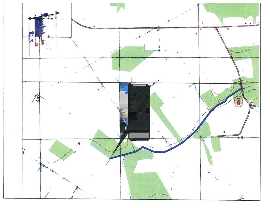
3 1.0 Project Background Atlantic Wind, LLC (Atlantic Wind) is proposing the development of the Desert Wind Power Project in Perquimans and Pasquotank Counties in eastern North Carolina, approximately 7.5 miles west of Elizabeth City and approximately 2.5 miles north of the Town of Winfall. The proposed project area has been situated on 24,242 acres of privately-owned land within Pasquotank and Perquimans counties in an area known locally as the Desert. The project area is located between Highway 158 to the north, Highway 17 to the east and south and County Road 1002 to the west. (See Figure 1-Vicinity Map in the Individual permit support document). For the purposes of this report, the following terminology is used to define the limits of the Desert Wind project. Project area Approximately 24,242 acres of privately owned land within Pasquotank and Perquimans counties in which Atlantic Wind, LLC has secured lease option agreements for the development of the Desert Wind project. Project corridor (Site) Approximately 2,513 acres of land located within the Project area where the specific project construction will occur. The Site consists primarily of agricultural fields (~ 71%) with areas of both jurisdictional and non-jurisdictional managed timberlands (~25%) and natural forested wetlands (~4%). While various technical studies referenced throughout this report were conducted for the larger Project area, the delineation of jurisdictional areas and the impact quantities presented as part of the Section 404/401 permit application are specifically for the Project corridor/site. The Site area was established based on the layout of the turbine locations, crane paths, access roads, transmission lines, and facilities. The corridor generally was defined by a 200-ft radius from each turbine location, 150-ft width for crane paths, 100-ft width for access roads, and 50-ft width for transmission lines. Permanent impacts to jurisdictional areas within the ~2,513 acre Site include acres of managed jurisdictional timberlands and 1.47 acres of impact to hardwood flat wetlands. 2.0 Project Description The project will consist of 150 modern wind turbines, each with a projected capacity of 2.0 MW, for a total installed capacity of 300 MW. The construction-related facilities will consist of the following: 150/ 2.0 MW Gamesa G97 wind turbine generators on 90 meter towers; Permanent and temporary access roads to each turbine; Temporary crane paths; Underground and overhead 34.5 kilovolt ( kv ) electrical collector lines connecting the turbines to the Collection Substation; A 34.5 kv to 115 kv Collection Substation facility; 1
4 A 115 to 230 kv Transmission Voltage Step-up Substation facility (the Step-up Substation ); An approximately 5.5 mile long, 115 kv overhead Sub-Transmission Line connecting the Collection Substation to the Step-up Substation; A 230 kv Interconnection Switching Station facility (the Switching Station ); An Operations and Maintenance ( O&M ) facility; One permanent meteorological tower; A temporary batch plant; and A temporary lay down and contractor staging area. The Facility will be interconnected with VEPCO s 230 kv Winfall to Suffolk line, which intersects the southwest portion of the Project Area in Perquimans County. Based upon current assessments, the 300 MW project is predicted to have a net production between 750,000 and 950,000 megawatt hours (MWhs) of electricity per year. The output from the Facility is estimated to power between 55,000 to 70,000 homes in North Carolina per year. In order to transmit the output of the Project to the location where it will be connected to the regional transmission system, Atlantic Wind will construct an overhead, 115 kv Sub- Transmission Line. The Transmission Voltage Step-up Substation will consist of a main transformer, circuit breakers, switching devices, auxiliary equipment, and a control enclosure containing equipment for the proper control, protection, monitoring, and communications. The principal function of the step-up substation is to increase the voltage from the sub-transmission line to that of the transmission line, by which the Project will interconnect with the regional transmission system. There will also be a VEPCO-owned and operated Interconnection Switching Station. The Switching Station will serve as the electrical interconnection between the Project and the regional transmission system. The Switching Station will consist of 230kV circuit breakers, disconnect switches, bus conductors, auxiliary equipment, and a control enclosure containing equipment for the proper control, protection, monitoring, and communications. The proposed site layout is shown in Figure 8 in the Individual permit support document. 3.0 Existing Site Conditions The proposed ~2,513 acre Site is located within the ~24,242 acre project area and is situated in an area that historically was the lower portion of the Great Dismal Swamp. However, most of the area has since been converted to active agricultural crop land and silvicultural uses through decades of land clearing, extensive drainage and intensive land management. The Site is currently managed for agriculture (wheat, corn, and soybean) and silviculture. The Site 2
5 contains extensive lateral ditches within the fields and forested areas, as well as larger collector and roadside ditches. The lateral and collector/roadside ditches ultimately discharge into the Perquimans, Pasquotank, and Little Rivers, and are therefore hydrologically connected to navigable waters of the U.S. and are considered jurisdictional waters under the Clean Water Act. Forested portions of the site, either under timber management or in more of a natural forested state, were determined by the USACE to be predominantly wetland as part of a preliminary determination performed for the project area. Although drainage ditches are present in most of these areas altering hydrology, portions of these areas still posses sufficient hydrology to meet wetland hydrology criteria and are therefore considered jurisdictional. A more detailed discussion of the existing site conditions and jurisdictional features is included in the Individual Permit Support Document. 4.0 Proposed Impacts Impacts to jurisdictional wetlands and waters will be avoided and minimized to the extent practical. However, the preferred alternative will result in acres of temporary impacts to jurisdictional waters (roadside canals and agricultural/silvicultural ditches) and 1.37 acres of permanent impacts to jurisdictional waters (roadside canals and agricultural/silvicultural ditches). The preferred alternative will also result in acres of temporary impact to managed jurisdictional wetlands (timber lands), acres of temporary impact to hardwood flat wetlands, and acres of permanent impact to managed jurisdictional wetlands (timber lands) and 1.47 acres of permanent impacts to hardwood flat wetlands. The temporary impacts associated with the project in the managed wetlands are similar in nature to the current timber clearing practices that are incurred in these areas as part of the forestry management plans. A more detailed discussion of the proposed project impacts is included in the Individual Permit Support Document. 5.0 Areas of Environmental Concern The project is located within Perquimans and Pasquotank counties, both of which are under the jurisdiction of the Coastal Area Management Act (CAMA). In order to assess whether the project required a CAMA Major Development Permit, it was necessary to determine if the project impacted Areas of Environmental Concern (AECs) as defined in the North Carolina Administrative Code 15A NCAC 07H. Based upon a field evaluation of the Site by N.C. Division of Coastal Management, (letter dated February 10, 2011 by Kelly Russell, NCDCM) it was determined that the project Site is not located within any NCDCM regulated AECs. A letter from NCDCM confirming their findings is included as Appendix A. The following information documents that the proposed project will be consistent with the State s coastal management program and that the consistency process is the appropriate form of DCM review of this project. 3
6 5.1 Estuarine and Ocean Systems (15A NCAC 07H.0200) This category of AECs includes those areas that are either geographically within an estuary or, because of its location and nature, may significantly affect the estuarine and ocean system. AECs included in estuarine and ocean system include: coastal wetlands, estuarine waters, public trust areas, and coastal shorelines Coastal Wetlands (15A NCAC 07H.0205) Coastal wetlands are defined as any salt marsh or other marsh subject to regular or occasional flooding by tides, including wind tides. Coastal wetlands include some if not all of the 10 identified marsh plant species. Kimley-Horn and Associates, Inc. delineated the wetlands at the site U.S. Army Corps of Engineers Wetland Delineation Manual, Atlantic and Gulf Coast Regional Supplement (Version 2.0, December 27, 2010). Field verification meetings with the USACE staff (Tracey Wheeler and Kyle Barnes) were conducted on April 26, May 25 and June 7, A Preliminary Jurisdictional Determination request of these jurisdictional features has been submitted to the USACE in conjunction with the Section 404 permit application package. Based upon the NC Wetland Assessment Methodology (NCWAM), the on-site wetlands are classified as pine flats and hardwood flats and are not flooded by ties and do not contained the coastal wetland marsh species. A detailed discussion of the delineated wetland features is included in the in the Individual Permit Support Document. Therefore, this project will not impact coastal wetland areas of environmental concern Estuarine Waters (15A NCAC 07H.0206) Estuarine waters include all of the waters of the Atlantic Ocean within the boundary of North Carolina and all of the waters of the bays, sounds, rivers, and tributaries thereto seaward of the dividing line between coastal fishing waters and inland fishing waters. No estuarine waters are located in the proposed project area; therefore, this project will not result in impacts to estuarine waters Public Trust Areas (15A NCAC 07H.0207) Public trust areas are all waters of the Atlantic Ocean and lands thereunder from the mean high water mark to the seaward limit of the State jurisdiction, including all natural bodies of water subject to measurable lunar tides and lands thereunder to the mean high water mark. These public trust areas include all navigable water bodies and lands thereunder to the mean high water level or mean water level as the case may be. The proposed project will not directly impact waters of the State of North Carolina and therefore not impact public trust areas. 4
7 5.1.4 Coastal Shorelines (15A NCAC 07H.0209) Coastal shorelines include estuarine shorelines and public trust shorelines. Estuarine shoreline areas of environmental concern are those non-ocean shorelines extending from the normal high water level or normal water level along the estuarine waters, estuary sounds, bays, fresh and brackish waters, and public trust areas for a distance 75 feet landward. No estuarine or public trust shorelines are located within the project area; therefore, the proposed project is outside of the estuarine shoreline area of environmental concern. 5.2 Ocean Hazard Areas (15A NCAC 07H.0300) This category is composed of AECs that are considered natural hazard areas along the Atlantic Ocean shoreline, where, because of their special vulnerability to erosion or other adverse effects of sand, wind, and water, uncontrolled or incompatible development could unreasonably endanger life or property. Ocean hazard areas include beaches, frontal dunes, inlet lands, and other areas in which geologic, vegetation and soil conditions indicate a substantial possibility of excessive erosion or flood damage. The project is not located along the Atlantic Ocean shoreline and contains no ocean hazard areas. Therefore, the proposed project is outside of the ocean hazard area of environmental concern. 5.3 Public Water Supplies (15A NCAC 07H.0400) This category of AECs includes valuable small surface water supply watersheds and public water supply fields. The project Site is located in the Pasquotank River Basin, North Carolina Division of Water Quality (NCDWQ) sub-basins and , and U.S. Geological Survey (USGS) Hydrologic Unit Code (HUC) The Perquimans River is the nearest stream reach to be classified by NCDWQ (Classification: C, Sw ) and the same classification applies to tributaries and modified natural channel that connect to this segment. The project is not located within a small surface water supply watershed or public water supply field. Therefore, the proposed project will not impact public water supplies. 5.4 Natural and Cultural Resource Areas (15A NCAC 07H.0500) This category of AECs includes fragile coastal natural and cultural resource areas and is defined as areas containing environmental, natural or cultural resources of more than local significance in which uncontrolled or incompatible development could result in major or irreversible damage to natural systems or cultural resources, scientific, education, or associative values, or aesthetic qualities Coastal Areas that Sustain Remnant Species (15A NCAC 07H.0505) Coastal areas that sustain remnant species are those areas that support native plants or animals determined to be rare or endangered (synonymous 5
8 with threatened and endangered), within the coastal area. Such places provide habitats necessary for the survival of existing populations or communities of rare or endangered species with the coastal area. There are no Threatened or Endangered species listed for Perquimans County by the USFWS (database update September 22, 2010). The only federally-listed endangered species for Pasquotank County by the USFWS is the shortnose sturgeon (Acipenser brevirostrum). Habitat for the shortnose sturgeon is not present within the project corridor (Site) and therefore the proposed project would have No Effect on this species. Atlantic Wind has coordinated with the USFWS and North Carolina Wildlife Resource Commission (NCWRC) with regards to avian and bat surveys for the Desert Wind Project. A detailed discussion of the avian and bat survey methodology is included in the in the Individual Permit Support Document. No endangered, threatened, or special concern species were documented during spring and fall migration bird surveys conducted for the project. The state-listed threatened Bald Eagle (a single sub-adult) was documented as a transient during the fall migration survey conducted on November 2, Although no longer protected under the federal Endangered Species Act, the Bald Eagle is federally protected under the Bald and Golden Eagle Protection Act. Bald Eagles may occasionally occur within the Project Area during spring and fall migration, and as transient individuals throughout the winter. Based on the primarily agricultural nature of the Project Area, it is unlikely that any other state or federally-listed threatened and endangered species would occur on a regular basis within the project area. Therefore, the proposed project will not impact coastal areas that sustain remnant species Coastal Complex Natural Areas (15A NCAC 07H.0506) Coastal complex natural areas are defined as lands that support native plant and animal communities and provide habitat qualities which have remained essentially unchanged by human activity. Such areas may be either significant components of coastal systems or especially notable habitat areas of scientific, educational, or aesthetic value. The proposed project is located in an area that historically was the lower portion of the Great Dismal Swamp. However, most of the area has since been converted to active agricultural crop land and silvicultural uses through decades of land clearing, extensive drainage and intensive land management. The project site is currently managed for agriculture (wheat, corn, and soybean) and silviculture. No coastal complex natural areas occur within the project area; therefore, the proposed project will not impact coastal areas that sustain remnant species Unique Coastal Geological Formations (15A NCAC 07H.0507) Unique coastal geological formations are defined as sites that contain geologic formations that are unique or otherwise significant components 6
9 of coastal systems, or that are especially notable examples of geological formations or processes in the coastal area. No unique coastal geological formations occur within the project area; therefore, the proposed project will not impact these areas of environmental concern Significant Coastal Archaeological Resources (15A NCAC 07H.0509) Significant coastal archaeological resources are defined in areas that contain archaeological remains (objects, features, and/or sites) that have more than local significance to history or prehistory. A Cultural Resource Assessment, Phase I Cultural Resource Survey, and Phase I Archeological Survey, in accordance with a NC Department of Cultural Resources approved work plan have been conducted for the proposed project area. A detailed discussion of these assessments and surveys is included in the in the Individual Permit Support Document. No significant coastal archaeological resources currently listed in the National Register of Historic Places or Eligible for the National Register will be impacted by the project Significant Coastal Historical Architectural Resources (15A NCAC 07H.0510) Significant coastal historic architectural resources are defined as districts, structures, buildings, sites or objects that have more than local significance to history or architecture. R. Christopher Goodwin and Associates, Inc. (RCGA) staff examined the site records at the North Carolina Department of Cultural Resources (NCDCR) for architectural resources that have been recorded in and within 1.5 miles of the proposed project area. Research included a review of the architectural quadrangle maps, survey reports, and architectural forms. Fifty-four previously recorded architectural resources were identified within the area. Of the fifty-four properties, none are currently listed in the National Register of Historic Places or Eligible for the National Register. RCGA initiated an Architectural Survey for the Site in late June This survey was conducted in accordance with the NCDCR approved work plan. A detailed discussion of these assessments and surveys is included in the in the Individual Permit Support Document. No significant coastal historical architectural resources currently listed in the National Register of Historic Places or Eligible for the National Register will be impacted by the project. 5.5 Outstanding Resource Waters (15A NCAC 02B.0225) Outstanding Resource Waters (ORW) is a supplemental surface water classification intended to protect unique and special waters having excellent water quality and being of exceptional state or national recreational or ecological 7
10 significance. There are no ORWs within or adjacent to the proposed project site; therefore, the proposed project will not impact ORWs. 5.6 High Quality Waters (15A NCAC 02B.0224) High Quality Waters (HQW) is a supplemental surface water classification intended to protect waters with quality higher than state water quality standards. No HQWs within or adjacent to the proposed project site; therefore, the proposed project will not impact HQWs. 5.7 Conclusion The proposed project is outside of any area of environmental concern. As defined in NC General Statute 113A-103(5)a, the project does not require authorization pursuant to the Coastal Area Management Act in that it will not occur in a duly designated area of environmental concern. The proposed project will not impact state designated ORWs or HQWs. 6.0 General Policy Guidelines Atlantic Wind, LLC has reviewed 15A NCAC 07M General Policy Guidelines for the coastal area and has determined that the proposed project is consistent with those guidelines. Certain sections of the Guidelines, specifically, Sections.0200 Shoreline Erosion Policies,.0300 Shoreline Access Policies,.0500 Post-Disaster Policies,.0600 Floating Structures Policies,.1000 Policies on Water and Wetland Based Target Areas for Military Training Activities,.1100 Policies on Beneficial Use and Availability of Materials Resulting from the Excavation or Maintenance of Navigational Channels, and.1200 Policies on Ocean Mining are not applicable to the proposed development activity. The project is consistent Section 7M.0400 Coastal Energy Policies. The proposed wind energy project does not involve off-shore exploration of resources and is sited inland of the shoreline area with no impacts to any area of environmental concern (AEC), barrier islands, or public trust waters or adjacent lands. The proposed project has been located and placed in a manner that allows for protection of the coastal environment and local and regional socio-economic goals as set forth in the local land-use plans and state guidelines in 15A NCAC 07H and 07M. A discussion of the environmental, economic and social consequences, including the cumulative and secondary impacts of the proposed project is included in the in the Individual Permit Support Document. Section 7M.0700 Mitigation Policies are addressed by the mitigation proposal presented to the U.S. Army Corps of Engineers by purchasing non-riparian wetland mitigation credits from the Great Dismal Swamp Restoration Bank Timberlake Farm Site located within the Pasquotank River Basin (HUC ) to compensate for the impacts associated with fill in Section 404 wetlands. Therefore, the mitigation policies in.07m are consistent with the proposed plan for development. 8
11 Section 7M.0800 Coastal Water Quality Policies have been addressed. Atlantic Wind, LLC met with NCDWQ staff from the 401 Certification and the Stormwater units on June 13, 2011 to discuss stormwater management design considerations for the project. The Desert Wind project is a Low Density Development since the total developed impervious area is minimal (9%) compared to the project s limits of disturbance. A detailed discussion of the proposed stormwater quality measures for the proposed project is included in the in the Individual Permit Support Document. Atlantic Wind, LLC will obtain a State Stormwater Permit prior to the initiation of construction of the proposed project. The project is consistent with Section 7M.0900 Policies and Use of coastal Air Space. Atlantic Wind, LLC has been in coordination with the Department of Defense (DOD) to ensure the proposed project is compatible with naval air space requirements. Studies conducted by the DOD indicated that the proposed project would not interfere with the Navy s operations. 6.1 Conclusion Based on the review of the General Policy Guidelines for Coastal Areas, we assert that the proposed project is consistent with T15A NCAC Subchapter 07M. 7.0 Land Use Plan Review The project area includes approximately 24,242 acres of land located in two counties, Pasquotank and Perquimans, in northeastern North Carolina. None of the project is within an incorporated municipality. Both Counties have Zoning Ordinances that indicate a Conditional Use Permit would be required for development of a wind farm. Perquimans County Atlantic Wind LLC filed a conditional use permit application (CUP) with the Perquimans County Planning Department on April 25, The Properties subject to the CUP Application (the Properties ) are zoned RA-Rural Agriculture ( RA ). Large Wind Energy Facilities are among the uses permitted on the Properties pursuant to the applicable provisions of the Zoning Ordinance. The CUP was issued by Perquimans County on July 6, Pasquotank County Atlantic Wind LLC filed a conditional use permit application (CUP) with the Pasquotank County Planning Department on April 25, The Properties subject to the CUP Application (the Properties ) are zoned A-2-Agricultural ( A-2 ). Large Wind Energy Facilities are among the uses permitted on the Properties pursuant to the applicable provisions of the Zoning Ordinance. The CUP was issued by Pasquotank County on June 13, Conclusion It is our determination that the proposed project is consistent with the Perquimans and Pasquotank County Land Use Plans. 9
12 8.0 Other State Permits Atlantic Wind, LLC will obtain all permits and approvals required by the state prior to the construction and operation of the Facility. 8.1 State Water Quality (401) Certification The NCDWQ 401 certification application is submitted concurrent to this 404 permit application. DWQ will also review the proposed plans for compliance with state stormwater requirements. 8.2 State Stormwater Permit The NCDWQ state stormwater application is submitted concurrent to this 404 permit application. It is anticipated that the application will be submitted through the State stormwater express review program. 8.3 Sedimentation and Erosion Control Permit As part of the 401 General Certification requirements, a Sediment and Erosion Control Plan will be required from the Division of Land Resources (DLR), which includes a NPDES General Stormwater Permit. Atlantic Wind will coordinate with the DLR regarding approval of a Sediment and Erosion Control Plan and NPDES General Stormwater Permit. 8.4 North Carolina Utilities Commission Certificate Atlantic Wind, LLC filed an application with the N.C. Utilities Commission on January 27, 2011 for a Certificate of Public Convenience and Necessity for the construction of a merchant plant and registration as a new renewable energy facility. This certificate was awarded to Atlantic Wind on May 3, Driveway Permit The North Carolina Department of Transportation (NCDOT) will require a Driveway Permit for any new roads that connect to an existing NCDOT right of way (ROW). A driveway permit will typically also be required if the use of an existing private road (driveway) that has a change in use (example from private to commercial) or has planned improvements. 9.0 Project Consistency Conclusion These supporting documents, in accordance with 15 CFR put forth the data necessary to assess our assertion of the project is consistent with the Federal Coastal Zone Management Act of 1972, as amended and the enforceable policies of the North Carolina approved Coastal Management Program. We request that the North Carolina Division of Coastal Management concur with our Consistency Certification that the proposed activity complies with the enforceable policies of the North Carolina Approved Management Program and will be conducted in a manner consistent with such Program 10
13 APPENDIX A NCDCM AND NCDWQ PROJECT REVIEW LETTERS
14


15


16


17
15A NCAC 07H.0209 COASTAL SHORELINES (a) Description. The Coastal Shorelines category includes estuarine shorelines and public trust shorelines.
 Description. The Coastal Shorelines category includes estuarine shorelines and public trust shorelines.") 15A NCAC 07H.0209 COASTAL SHORELINES (a) Description. The Coastal Shorelines category includes estuarine shorelines and public trust shorelines. Estuarine shorelines AEC are those non-ocean shorelines
15A NCAC 07H.0209 COASTAL SHORELINES (a) Description. The Coastal Shorelines category includes estuarine shorelines and public trust shorelines. Estuarine shorelines AEC are those non-ocean shorelines
PUBLIC NOTICE. Section 404 of the Clean Water Act (33 U.S.C. 1344) Section 10 of the Rivers and Harbors Act of 1899 (33 U.S.C.
 Section 10 of the Rivers and Harbors Act of 1899 (33 U.S.C.") US Army Corps Of Engineers Wilmington District PUBLIC NOTICE Issue Date: May 30, 2013 Comment Deadline: June 30, 2013 Corps Action ID Number: SAW-2005-11122 The Wilmington District, Corps of Engineers
US Army Corps Of Engineers Wilmington District PUBLIC NOTICE Issue Date: May 30, 2013 Comment Deadline: June 30, 2013 Corps Action ID Number: SAW-2005-11122 The Wilmington District, Corps of Engineers
PUBLIC NOTICE. Section 404 of the Clean Water Act (33 U.S.C. 1344) Section 10 of the Rivers and Harbors Act of 1899 (33 U.S.C.
 Section 10 of the Rivers and Harbors Act of 1899 (33 U.S.C.") US Army Corps Of Engineers Wilmington District PUBLIC NOTICE Issue Date: June 17, 2014 Comment Deadline: July 17, 2014 Corps Action ID#: SAW-2009-00655 NC DOT TIP: R-4903 The Wilmington District, Corps
US Army Corps Of Engineers Wilmington District PUBLIC NOTICE Issue Date: June 17, 2014 Comment Deadline: July 17, 2014 Corps Action ID#: SAW-2009-00655 NC DOT TIP: R-4903 The Wilmington District, Corps
NOTICE OF PREPARATION OF AN ENVIRONMENTAL IMPACT REPORT
 Date: September 18, 2017 NOTICE OF PREPARATION OF AN ENVIRONMENTAL IMPACT REPORT To: Agencies and Interested Parties Lead Agency: Sacramento Municipal Utility District 6201 S Street, MS H201 Sacramento,
VEGETATIVE, WATER, FISH AND WILDLIFE RESOURCES POLICIES
 VEGETATIVE, WATER, FISH AND WILDLIFE RESOURCES POLICIES The County will: GOALS AND OBJECTIVES 1.1 Conserve, Enhance, Protect, Maintain and Manage Vegetative, Water, Fish and Wildlife Resources Promote
J O I N T P U B L I C N O T I C E
 DEPARTMENT OF THE ARMY U.S. ARMY CORPS OF ENGINEERS, SAVANNAH DISTRICT 100 W. OGLETHORPE AVENUE SAVANNAH, GEORGIA 31401-3604 J O I N T P U B L I C N O T I C E CHARLESTON AND SAVANNAH DISTRICTS- US ARMY
PUBLIC NOTICE. US Army Corps Of Engineers Wilmington District
 US Army Corps Of Engineers Wilmington District PUBLIC NOTICE Issue Date: September 30, 2013 Comment Deadline: October 30, 2013 Corps Action ID Number: SAW-2013-00534 The Wilmington District, Corps of Engineers
PUBLIC NOTICE. Section 404 of the Clean Water Act (33 U.S.C. 1344) Section 10 of the Rivers and Harbors Act of 1899 (33 U.S.C.
 Section 10 of the Rivers and Harbors Act of 1899 (33 U.S.C.") US Army Corps Of Engineers Wilmington District PUBLIC NOTICE Issue Date: September 19, 2013 Comment Deadline: October 19, 2013 Corps Action ID Number: SAW-2004-11082 The Wilmington District, Corps of Engineers
US Army Corps Of Engineers Wilmington District PUBLIC NOTICE Issue Date: September 19, 2013 Comment Deadline: October 19, 2013 Corps Action ID Number: SAW-2004-11082 The Wilmington District, Corps of Engineers
Ohio Power Siting Board. Staff Investigation Report and Recommendation
 Ohio Power Siting Board Staff Investigation Report and Recommendation Case No.: 11-1995-EL-BGA Project: Amendment to Blue Creek Wind Farm Certificate of Environmental Compatibility and Public Need Applicant:
15A NCAC 07H.0308 SPECIFIC USE STANDARDS FOR OCEAN HAZARD AREAS (a) Ocean Shoreline Erosion Control Activities: (1) Use Standards Applicable to all
 Ocean Shoreline Erosion Control Activities: (1) Use Standards Applicable to all") 15A NCAC 07H.0308 SPECIFIC USE STANDARDS FOR OCEAN HAZARD AREAS (a) Ocean Shoreline Erosion Control Activities: (1) Use Standards Applicable to all Erosion Control Activities: (A) All oceanfront erosion
15A NCAC 07H.0308 SPECIFIC USE STANDARDS FOR OCEAN HAZARD AREAS (a) Ocean Shoreline Erosion Control Activities: (1) Use Standards Applicable to all Erosion Control Activities: (A) All oceanfront erosion
Environmental Check List Georgia Environmental Policy Act
 Environmental Check List Georgia Environmental Policy Act Project No. : Project Name: GEORGIA IS AREA AFFECTED? IF AFFECTED, HOW SEVERELY? AREA/CATEGORY NO YES UNKNOWN MINOR MEDIAN MAJOR UNKNOWN 1. Wetlands
ENVIRONMENTAL ASSESSMENT
 ENVIRONMENTAL ASSESSMENT Section 408 Request to Alter the Dubois Local Protection Project for the Beaver Drive sidewalk construction in Clearfield County, PA June 28, 2018 Prepared By: Environmental and
PUBLIC NOTICE. HDC-Wendover-Greensboro Partners, LP Mr. Key Kasravi Kingsride Lane, Suite 280 Houston, Texas 77024
 US Army Corps Of Engineers Wilmington District PUBLIC NOTICE Issue Date: April 6, 2015 Comment Deadline: May 6, 2015 Corps Action ID Number: SAW-2013-01863 The Wilmington District, Corps of Engineers (Corps)
PUBLIC NOTICE. Mr. Jon Morris Beacon Partners, Inc 610 East Morehead Street Charlotte, North Carolina 28202
 US Army Corps Of Engineers Wilmington District PUBLIC NOTICE Issue Date: July 31, 2013 Comment Deadline: August 30, 2013 Corps Action ID Number: SAW-2013-01263 The Wilmington District, Corps of Engineers
ATTACHMENT 1 GEPA CHECKLIST & Historical Archeological & Natural Heritage Preservation Documents
 ATTACHMENT 1 GEPA CHECKLIST & Historical Archeological & Natural Heritage Preservation Documents INTRODUCTION The 1991 Session of the Georgia General Assembly passed Senate Bill 97, as amended, and it
1.0 INTRODUCTION 1.1 SUMMARY OF SEQRA PROCESS
 1.0 INTRODUCTION This is prepared for the Jericho Rise Wind Farm (hereafter, the Project ) pursuant to the New York State Environmental Quality Review Act (SEQRA) and its implementing regulations, 6 NYCRR
Public Notice ISSUED: July 13, 2018 EXPIRES: August 13, 2018
 APPLICANT: Sargento Foods Inc. Public Notice ISSUED: July 13, 2018 EXPIRES: August 13, 2018 REFER TO: 2010-2909-RJH SECTION: 404 - Clean Water Act 1. APPLICATION FOR PERMIT TO discharge dredged and fill
Public Notice ISSUED: December 11, 2018 EXPIRES: January 10, 2019
 APPLICANT: Hibbing Taconite Mine Public Notice ISSUED: December 11, 2018 EXPIRES: January 10, 2019 REFER TO: 2017-02800-DWW SECTION: 404 - Clean Water Act 1. APPLICATION FOR PERMIT TO retain fill material
Public Notice ISSUED: April 5, 2019 EXPIRES: May 6, 2019
 APPLICANT: Aitkin County Highway Department Public Notice ISSUED: April 5, 2019 EXPIRES: May 6, 2019 REFER TO: MVP-2019-00387-EJI SECTION: 404 - Clean Water Act 1. APPLICATION FOR PERMIT TO discharge fill
VILLAGE OF BALD HEAD ISLAND SHORELINE PROTECTION PROJECT DRAFT ENVIRONMENTAL IMPACT STATEMENT
 VILLAGE OF BALD HEAD ISLAND SHORELINE PROTECTION PROJECT DRAFT ENVIRONMENTAL IMPACT STATEMENT Prepared By: U.S. Army Corps of Engineers Wilmington District and Land Management Group, Inc. (Third Party
APPENDIX N Guidance for Preparing/Reviewing CEQA Initial Studies and Environmental Impact Reports
 APPENDIX N N.1 Guidance for Preparing and Reviewing CEQA Initial Studies Step 1: Consider the Project Characteristics as Provided by the Project Applicant Review the project application and draft plan
3.0 UNAVOIDABLE ADVERSE IMPACTS. 3.1 General Mitigation Measures
 3.0 UNAVOIDABLE ADVERSE IMPACTS The purpose of the Project is to create a reliable and profitable wind-powered electric generation facility that will provide a significant source of clean, renewable energy
List of Figures... xii. List of Tables... xiii. List of Appendices...xv. Glossary... xvii Project Summary and Facility Overview...
 BEFORE THE OHIO POWER SITING BOARD Application of a Certificate of Environmental Compatibility and Public Need Blue Creek Wind Farm Amendment Table of Contents Text sections that have been updated for
PUBLIC NOTICE. Section 404 of the Clean Water Act (33 U.S.C. 1344) Section 10 of the Rivers and Harbors Act of 1899 (33 U.S.C.
 Section 10 of the Rivers and Harbors Act of 1899 (33 U.S.C.") US Army Corps Of Engineers Wilmington District PUBLIC NOTICE Issue Date: February 27, 2017 Comment Deadline: March 13, 2017 Corps Action ID Number: SAW-2009-01449 TIP No. R-2707C The Wilmington District,
US Army Corps Of Engineers Wilmington District PUBLIC NOTICE Issue Date: February 27, 2017 Comment Deadline: March 13, 2017 Corps Action ID Number: SAW-2009-01449 TIP No. R-2707C The Wilmington District,
SUBCHAPTER 7K - ACTIVITIES IN AREAS OF ENVIRONMENTAL CONCERN WHICH DO NOT REQUIRE A COASTAL AREA MANAGEMENT ACT PERMIT
 SUBCHAPTER 7K - ACTIVITIES IN AREAS OF ENVIRONMENTAL CONCERN WHICH DO NOT REQUIRE A COASTAL AREA MANAGEMENT ACT PERMIT SECTION.0100 - ACTIVITIES NOT CONSIDERED DEVELOPMENT 15A NCAC 07K.0101 STATUTORY EXCEPTIONS
Public Notice U.S. Army Corps In Reply to Application Number of Engineers
 Public Notice U.S. Army Corps In Reply to Application Number of Engineers CENAB-OP-RMS(HERITAGE GREEN DEVELOPMENT/RD Baltimore District XING, CULVERTS, LOT FILL & SWM POND) 2006-63551 PN 15-21 Comment
J O I N T P U B L I C N O T I C E
 J O I N T P U B L I C N O T I C E CHARLESTON DISTRICT, CORPS OF ENGINEERS 69A Hagood Avenue Charleston, South Carolina 29403-5107 and THE S.C. DEPARTMENT OF HEALTH AND ENVIRONMENTAL CONTROL Office of Environmental
Department of the Army Permit Application
 Department of the Army Permit Application DA File Number U.S. Army Corps of Engineers Honolulu District Date Received by CEPOH-RO Send Completed Application to: Honolulu District, U.S. Army Corps of Engineers
BEFORE THE OHIO POWER SITING BOARD
 BEFORE THE OHIO POWER SITING BOARD Application of a Certificate of Environmental Compatibility and Public Need Table of Contents Page No. List of Figures... xii List of Tables... xiii List of Appendices...xv
NC DEQ Division of Energy, Mineral and Land Resources STATE STORMWATER FAST TRACK AUTHORIZATION TO CONSTRUCT PERMIT APPLICATION INSTRUCTIONS
 NC DEQ Division of Energy, Mineral and Land Resources STATE STORMWATER FAST TRACK AUTHORIZATION TO CONSTRUCT PERMIT APPLICATION INSTRUCTIONS A. ELIGIBILITY FOR FAST-TRACK PERMITTING Before applying for
ORD WHEREAS, the public necessity, convenience, general welfare and good zoning practice so require;
 ORD-3370 1 2 3 4 5 6 7 8 9 10 11 12 13 14 15 16 17 18 19 20 21 22 23 24 25 26 27 28 29 30 31 32 33 34 35 36 37 AN ORDINANCE TO AMEND SECTIONS 1, 2, 3, 5, 7, 9, 11, 12 AND 14 OF THE SOUTHERN WATERSHEDS
SUBCHAPTER 7B CAMA STATE GUIDELINES FOR LAND USE PLANNING. 15A NCAC 07B.0601 is amended with changes as published in 30:06 NCR 620 as follows:
 1 1 1 SUBCHAPTER B CAMA STATE GUIDELINES FOR LAND USE PLANNING 1A NCAC 0B.001 is amended with changes as published in 0:0 NCR 0 as follows: 1A NCAC 0B.001 AUTHORITY This Subchapter establishes the rules
J O I N T P U B L I C N O T I C E
 J O I N T P U B L I C N O T I C E CHARLESTON DISTRICT, CORPS OF ENGINEERS 69A Hagood Avenue Charleston, South Carolina 29403-5107 and THE S.C. DEPARTMENT OF HEALTH AND ENVIRONMENTAL CONTROL Office of Ocean
DEPARTMENT OF THE ARMY U.S. ARMY CORPS OF ENGINEERS - MOBILE DISTRICT BIRMINGHAM FIELD OFFICE 218 SUMMIT PARKWAY, SUITE 222 HOMEWOOD, AL 35209
 DEPARTMENT OF THE ARMY U.S. ARMY CORPS OF ENGINEERS - MOBILE DISTRICT BIRMINGHAM FIELD OFFICE 218 SUMMIT PARKWAY, SUITE 222 HOMEWOOD, AL 35209 CESAM-RD-I-N December 7, 2012 PUBLIC NOTICE NO. SAM-2012-01506-LCB
JOINT PUBLIC NOTICE U.S. ARMY CORPS OF ENGINEERS MISSISSIPPI DEPARTMENT OF ENVIRONMENTAL QUALITY OFFICE OF POLLUTION CONTROL
 DEPARTMENT OF THE ARMY U.S. ARMY ENGINEER DISTRICT, MOBILE DISTRICT P.O. BOX 2288 MOBILE, ALABAMA 36628-0001 CESAM-RD-C PUBLIC NOTICE NO. SAM-2015-00374-MJF July 10, 2015 JOINT PUBLIC NOTICE U.S. ARMY
P U B L I C N O T I C E. CHARLESTON DISTRICT, CORPS OF ENGINEERS 69A Hagood Avenue Charleston, South Carolina
 P U B L I C N O T I C E CHARLESTON DISTRICT, CORPS OF ENGINEERS 69A Hagood Avenue Charleston, South Carolina 29403-5107 REGULATORY DIVISION Refer to: P/N SAC-2018-00950 June 14, 2018 Pursuant to Section
PUBLIC NOTICE NO. FP13-AB03-05 August 30, 2013 CESAM-PD-EC JOINT PUBLIC NOTICE
 DEPARTMENT OF THE ARMY MOBILE DISTRICT, CORPS OF ENGINEERS P.O. BOX 2288 MOBILE, ALABAMA 36628-0001 REPLY TO ATTENTION OF: JOINT PUBLIC NOTICE U. S. ARMY CORPS OF ENGINEERS, MOBILE DISTRICT AND FLORIDA
THIS IS NOT A PAID ADVERTISEMENT. Public Notice. Public Notice No. CENAP-OP-R February 13, 2019
 THIS IS NOT A PAID ADVERTISEMENT Public Notice Wanamaker Building 100 Penn Square East Philadelphia, PA 19107-3390 ATTN: CENAP-OP-R Public Notice No. Date CENAP-OP-R-2012-0699 February 13, 2019 Application
PUBLIC NOTICE.
 US Army Corps Of Engineers Wilmington District PUBLIC NOTICE Issue Date: April 01, 2019 Comment Deadline: May 01, 2019 Corps Action ID Number: SAW-2019-00428 The Wilmington District, Corps of Engineers
CESAM-RD-N January 10, 2018 PUBLIC NOTICE NO. SAM CMS
 DEPARTMENT OF THE ARMY MOBILE DISTRICT, CORPS OF ENGINEERS BIRMINGHAM FIELD OFFICE 218 SUMMIT PARKWAY, SUITE 222 HOMEWOOD, ALABAMA 35209 CESAM-RD-N January 10, 2018 PUBLIC NOTICE NO. SAM-2017-01301-CMS
Public Notice. Permit Application No.: SWF Date: December 20, 2012
 Public Notice Applicant: The City of The Colony Permit Application No.: SWF-2012-00231 Date: December 20, 2012 The purpose of this public notice is to inform you of a proposal for work in which you might
PA Fish and Boat Commission No Known Impact No Further Review Required U.S. Fish and Wildlife Service No Known Impact No Further Review Required
 1. PROJECT INFORMATION Project Name: Infinity Natural Resources Coastal #2 Date of Review: 4/24/2018 01:09:22 PM Project Category: Energy Storage, Production, and Transfer, Energy Production (generation),
APPENDIX H Guidance for Preparing/Reviewing CEQA Initial Studies and Environmental Impact Reports
 APPENDIX H H.1 Guidance for Preparing and Reviewing CEQA Initial Studies Step 1: Consider the Project Characteristics as Provided by the Project Applicant Review the project application and draft plan
NC Division of Coastal Management
 NC Ken Richardson Department of Environmental Quality NC Coastal Area Management Act (1974) Balances competing coastal pressures through development permitting and creation of a Coastal Resources Commission
THIS IS NOT A PAID ADVERTISEMENT. Public Notice. Public Notice No. CENAP-OP-R September 7, 2017
 THIS IS NOT A PAID ADVERTISEMENT Public Notice Wanamaker Building 100 Penn Square East Philadelphia, PA 19107-3390 ATTN: CENAP-OP-R Public Notice No. Date CENAP-OP-R-2017-00042 September 7, 2017 Application
PUBLIC NOTICE. Attn: Mr. Bill Mumford 1312 Briar Chapel Parkway Chapel Hill, NC 27516
 US Army Corps Of Engineers Wilmington District PUBLIC NOTICE Issue Date: December 5, 2016 Comment Deadline: December 20, 2016 Corps Action ID Number: SAW-2001-21252 The Wilmington District, Corps of Engineers
9 OTHER CONSIDERATIONS REQUIRED BY NEPA
 9 OTHER CONSIDERATIONS REQUIRED BY NEPA 9.1 CONSISTENCY WITH OTHER FEDERAL, STATE, AND LOCAL LAWS, PLANS, POLICIES, AND REGULATIONS In accordance with 40 Code of Federal Regulations (CFR) section 1502.16(c),
New Jersey Statewide Stormwater, Flood Hazard and Wetlands Programs
 New Jersey Statewide Stormwater, Flood Hazard and Wetlands Programs Authorities Federal Clean Water Act NJ Water Pollution Control Act NJ Stormwater Management Act Soil Erosion and Sediment Control Act
Public Notice. Applicant: Lennar Homes Project No.: SWF Date: October 29, Name: Mr. Darvin Messer Phone Number:
 Public Notice Applicant: Lennar Homes Project No.: SWF-2013-00265 Date: October 29, 2013 The purpose of this public notice is to inform you of a proposal for work in which you might be interested. It is
Public Notice. Applicant: TXI Operating, LP Project No.: SWF Date: April 2, Name: Mr. Darvin Messer Phone Number:
 Public Notice Applicant: TXI Operating, LP Project No.: SWF-2012-00125 Date: April 2, 2013 The purpose of this public notice is to inform you of a proposal for work in which you might be interested. It
15A NCAC 02B.0238 NEUSE RIVER BASIN-NUTRIENT SENSITIVE WATERS MANAGEMENT STRATEGY: AGRICULTURAL NITROGEN REDUCTION STRATEGY The following
 15A NCAC 02B.0238 NEUSE RIVER BASIN-NUTRIENT SENSITIVE WATERS MANAGEMENT STRATEGY: AGRICULTURAL NITROGEN REDUCTION STRATEGY The following requirements apply to all persons in the Neuse River Basin who
APPLICANT: Decatur Head Beach Association 1327 Decatur Head Drive Decatur Island Anacortes, WA Telephone: (425)
") US Army Corps of Engineers Seattle District Joint Public Notice Application for a Department of the Army Permit and a Washington Department of Ecology Water Quality Certification and/or Coastal Zone Management
US Army Corps of Engineers Seattle District Joint Public Notice Application for a Department of the Army Permit and a Washington Department of Ecology Water Quality Certification and/or Coastal Zone Management
PUBLIC NOTICE. Dredge, with 10-years maintenance, and placement of sand on an adjacent beach
 PUBLIC NOTICE US Army Corps of Engineers New York District Jacob K. Javits Federal Building New York, N.Y. 10278-0090 ATTN: Regulatory Branch In replying refer to: Public Notice Number: NAN-2017-00816-EKN
Project Information. Pursuant to Section 404 of the Clean Water Act (33 U.S. Code 1344), notice is hereby given that
, notice is hereby given that") US ARMY Corps Of Engineers Little Rock District JOINT PUBLIC NOTICE CORPS OF ENGINEERS STATE OF ARKANSAS Application Number: 2013-00171 Date: August 9, 2013 Comments Due: September 9, 2013 TO WHOM IT MAY
US ARMY Corps Of Engineers Little Rock District JOINT PUBLIC NOTICE CORPS OF ENGINEERS STATE OF ARKANSAS Application Number: 2013-00171 Date: August 9, 2013 Comments Due: September 9, 2013 TO WHOM IT MAY
DEPARTMENT OF THE ARMY U.S. ARMY CORPS OF ENGINEERS MOBILE DISTRICT MONTGOMERY FIELD OFFICE 105 SOUTH TURNER BOULEVARD MONTGOMERY, ALABAMA 36114
 DEPARTMENT OF THE ARMY U.S. ARMY CORPS OF ENGINEERS MOBILE DISTRICT MONTGOMERY FIELD OFFICE 105 SOUTH TURNER BOULEVARD MONTGOMERY, ALABAMA 36114 CESAM-RD-N May 21, 2018 PUBLIC NOTICE NO. SAM-2006-01867-JAP
CESAM-RD-N May 29, 2014 PUBLIC NOTICE NO. SAM JSC
 DEPARTMENT OF THE ARMY U.S. ARMY CORPS OF ENGINEERS MOBILE DISTRICT MONTGOMERY FIELD OFFICE 605 MAPLE STREET BUILDING 1429, ROOM 105 MAXWELL AFB, AL 36112 CESAM-RD-N May 29, 2014 PUBLIC NOTICE NO. SAM-2014-00173-JSC
Public Notice ISSUED: April 12, 2019 EXPIRES: May 13, 2019
 APPLICANT: Bad River Band of Lake Superior Chippewa Tribe Public Notice ISSUED: April, 09 EXPIRES: May 3, 09 REFER TO: 08-03046-JMB SECTION:404 - Clean Water Act. APPLICATION FOR PERMIT TO discharge fill
Notice of Availability (NOA) of the Draft Environmental Impact Statement. (DEIS) and the Announcement of a Public Hearing for the Installation of a
 of the Draft Environmental Impact Statement. (DEIS) and the Announcement of a Public Hearing for the Installation of a") This document is scheduled to be published in the Federal Register on 08/28/2015 and available online at http://federalregister.gov/a/2015-21282, and on FDsys.gov BILLING CODE: 3720-58 DEPARTMENT OF DEFENSE
This document is scheduled to be published in the Federal Register on 08/28/2015 and available online at http://federalregister.gov/a/2015-21282, and on FDsys.gov BILLING CODE: 3720-58 DEPARTMENT OF DEFENSE
Avian and Bat Studies Summary Presentation
 PLEASANT RIDGE EXHIBIT 113 Avian and Bat Studies Summary Presentation Pleasant Ridge Energy LLC Livingston County, Illinois Personal Qualifications Terry VanDeWalle BS in Animal Ecology; MA in Biology
Albemarle Resource Conservation and Development Council. Examples of Projects in Land and Water Conservation
 Examples of Projects in Land and Water Conservation The Albemarle RC&D Council partners with local governments, state and federal agencies, schools and other non-profit groups in 10 counties around the
Project Information. Pursuant to Section 404 of the Clean Water Act (33 U.S. Code 1344), notice is hereby given that
, notice is hereby given that") US ARMY Corps Of Engineers Little Rock District JOINT PUBLIC NOTICE CORPS OF ENGINEERS STATE OF ARKANSAS Application Number: 2013-00331 Date: November 4, 2013 Comments Due: December 4, 2013 TO WHOM IT
US ARMY Corps Of Engineers Little Rock District JOINT PUBLIC NOTICE CORPS OF ENGINEERS STATE OF ARKANSAS Application Number: 2013-00331 Date: November 4, 2013 Comments Due: December 4, 2013 TO WHOM IT
County of San Mateo Planning and Building Department
 County of San Mateo Planning and Building Department Coastal Development Permit EXEMPTION/EXCLUSION WORKSHEET (Categorical Exclusion Order E-81-1) (This is not a Certificate of Exemption) To be used by
DEPARTMENT OF THE ARMY CORPS OF ENGINEERS, MOBILE DISTRICT P.O. BOX 2288 MOBILE, AL
 DEPARTMENT OF THE ARMY CORPS OF ENGINEERS, MOBILE DISTRICT P.O. BOX 2288 MOBILE, AL 36628-0001 CESAM RD-A April 15, 2018 PUBLIC NOTICE NO. SAM-2018-01191-DCH JOINT PUBLIC NOTICE U.S. ARMY CORPS OF ENGINEERS
EXECUTIVE SUMMARY. Supplemental Environmental Impact Statement Jericho Rise Wind Farm
 EXECUTIVE SUMMARY This (SEIS) has been prepared for the proposed Jericho Rise Wind Farm (the Project). LLC (the Applicant), a wholly owned subsidiary of EDP Renewables (EDPR), is proposing to construct
PERMIT APPLICATION FEES Fees must be paid at time of application
 Permits SEPA Checklist Permit # Staff use Governmental agencies use this checklist to help determine whether the environmental impacts of your proposal are significant. This information is also helpful
Pteragen Canada Inc.
 Decision 2013-171 May 7, 2013 The Alberta Utilities Commission Decision 2013-171: Application No. 1608907 Proceeding ID No. 2181 May 7, 2013 Published by The Alberta Utilities Commission Fifth Avenue Place,
APPENDIX M CEQA Initial Study Checklist
 APPENDIX M CEQA Initial Study Checklist Appendix G ENVIRONMENTAL CHECKLIST FORM (To be Completed by Applicant) 1. Project title: 2. Lead agency name and address: 3. Contact person and phone number: 4.
Shrewsbury River Basin, Sea Bright, New Jersey Coastal Storm Risk Management Feasibility Study
 Shrewsbury River Basin, Sea Bright, New Jersey Coastal Storm Risk Management Feasibility Study Draft Integrated Feasibility Report & Environmental Assessment Appendix E: Pertinent Correspondence & Environmental
Atlantic Coast of NY, East Rockaway Inlet to Rockaway Inlet and Jamaica Bay APPENDIX N COASTAL ZONE MANAGEMENT
 Atlantic Coast of NY, East Rockaway Inlet to Rockaway Inlet and Jamaica Bay APPENDIX N COASTAL ZONE MANAGEMENT Hurricane Sandy General Reevaluation Report August 2016 New York (and New York City Local
PA Game Commission No Known Impact No Further Review Required
 1. PROJECT INFORMATION Project Name: Sustainable Park (Benckini Property) Date of Review: 5/22/2017 11:44:45 AM Project Category: Recreation, Other Project Area: 10.42 acres County(s): Lehigh Township/Municipality(s):
CESAM-RD-M March 16, 2018 PUBLIC NOTICE NO. SAM RCV JOINT PUBLIC NOTICE U.S. ARMY CORPS OF ENGINEERS
 DEPARTMENT OF THE ARMY U.S. ARMY ENGINEER DISTRICT, MOBILE DISTRICT P.O. BOX 2288 MOBILE, ALABAMA 36628-0001 CESAM-RD-M March 16, 2018 PUBLIC NOTICE NO. SAM-2017-00-RCV JOINT PUBLIC NOTICE U.S. ARMY CORPS
14. Sustainable Forestry Principals
 14. Sustainable Forestry Principals Fish River Lakes Concept Plan Addendum Materials April 2018 14. SUSTAINABLE FORESTRY PRINCIPLES In response to our discussion with LUPC Staff and others on the topic
Public Notice U.S. ARMY CORPS OF ENGINEERS, GALVESTON DISTRICT
 Public Notice U.S. Army Corps Permit Application No: SWG-2008-00106 Of Engineers Date Issued: 11 April 2017 Galveston District Comments Due: 11 May 2017 U.S. ARMY CORPS OF ENGINEERS, GALVESTON DISTRICT
CATEGORY a protection of the natural environment, its ecosystems and biodiversity.
 29. ENVIRONMENTAL DEVELOPMENT PERMIT AREA CATEGORY a protection of the natural environment, its ecosystems and biodiversity. The requirement to obtain an environmental development permit is cited in Section
Natural & Cultural Resources
 II. Natural & Cultural Resources Hydrology/Water Management The North Thousand Islands is located within the Banana River and within the Indian River Lagoon system. Significant waterbodies within the region
CESAM-RD-N January 21, 2016 PUBLIC NOTICE NO. SAM JSC
 DEPARTMENT OF THE ARMY MOBILE DISTRICT, CORPS OF ENGINEERS MONTGOMERY FIELD OFFICE 605 MAPLE STREET BUIKDING 1429, ROOM 105 MAXWELL AIR FORCE BASE, ALABAMA 36112 PUBLIC NOTICE NO. JOINT PUBLIC NOTICE U.S.
Public Notice ISSUED: March 18, 2016 EXPIRES: April 18, 2016
 APPLICANT: REFER TO: Mattamy Homes 2005-04142-PRH Public Notice ISSUED: March 18, 2016 EXPIRES: April 18, 2016 SECTION: 404 - Clean Water Act 1. APPLICATION FOR PERMIT to discharge dredged and fill material
SECONDARY WETLAND IMPACTS ANALYSIS
 SECONDARY WETLAND IMPACTS ANALYSIS USACE File. SWG-2012-00153 During the development of the Grand Parkway (State Highway 99) Segments H and I-1 from United States Highway 59/Interstate Highway 69 N to
CESAM-RD- N April 2, 2013 PUBLIC NOTICE NO. SAM CHE
 REPLY TO ATTENTION OF DEPARTMENT OF THE ARMY U.S. ARMY ENGINEER DISTRICT, MOBILE CORPS OF ENGINEERS BIRMINGHAM FIELD OFFICE 218 SUMMIT PARKWAY, SUITE 222 HOMEWOOD, ALABAMA 35209 CESAM-RD- N April 2, 2013
Public Notice No Metropolitan Avenue Charlotte, North Carolina 27204
 Public Notice US Army Corps of Engineers Louisville District Public Notice No. Open Date: Close Date: LRL-2016-239--mck 16 Mar 2016 15 Apr 2016 Please address all comments and inquiries to: U.S. Army Corps
DEPARTMENT OF THE ARMY CORPS OF ENGINEERS, MOBILE DISTRICT P.O. BOX 2288 MOBILE, ALABAMA CESAM-RD-A-S August 21, 2018
 DEPARTMENT OF THE ARMY CORPS OF ENGINEERS, MOBILE DISTRICT P.O. BOX 2288 MOBILE, ALABAMA 36628-0001 CESAM-RD-A-S August 21, 2018 JOINT PUBLIC NOTICE SAM-2017-00288-JEB U.S. ARMY CORPS OF ENGINEERS AND
PUBLIC NOTICE. Specific plans are shown at the following website:
 US Army Corps Of Engineers Wilmington District PUBLIC NOTICE Issue Date: October 11, 2017 Comment Deadline: November 9, 2017 Corps Action ID Number: SAW-2017-02112 The Wilmington District, Corps of Engineers
City of Bishop. Environmental Checklist Form
 City of Bishop Environmental Checklist Form 1. Project title: Environmental Review / 2007 California Building Codes 2. Lead agency name and address: City of Bishop 377 W. Line Street Bishop, Ca 93514 3.
DEPARTMENT OF THE ARMY CORPS OF ENGINEERS, MOBILE DISTRICT P.O. BOX 2288 MOBILE, AL
 DEPARTMENT OF THE ARMY CORPS OF ENGINEERS, MOBILE DISTRICT P.O. BOX 2288 MOBILE, AL 36628-0001 CESAM-RD-A October 23, 2018 PUBLIC NOTICE NO. SAM-2018-00773-LET JOINT PUBLIC NOTICE U.S. ARMY CORPS OF ENGINEERS
PUBLIC NOTICE. Village of Bald Head Island Mr. Chris McCall, Village Manager Post Office Box 3009 Bald Head Island, North Carolina
 US Army Corps Of Engineers Wilmington District PUBLIC NOTICE Issue Date: November 20, 2017 Comment Deadline: December 20, 2017 Corps Action ID Number: SAW-2012-00040 On November 19, 2014, the Wilmington
PUBLIC NOTICE. Attn: Mr. John Koenig 235 Green Street Fayetteville, North Carolina 28301
 US Army Corps Of Engineers Wilmington District PUBLIC NOTICE Issue Date: February 4, 2013 Comment Deadline: March 4, 2013 Corps Action ID #: SAW-2010-01947 The Wilmington District, Corps of Engineers (Corps)
JOINT PUBLIC NOTICE August 4, 2014
 JOINT PUBLIC NOTICE August 4, 2014 United States Army State of Louisiana Corps of Engineers Department of Environmental Quality New Orleans District Water Quality Certifications Section Regulatory Branch
Maryland s s Critical Area Program
 Maryland s s Critical Area Program Overview of the Critical Area Program Highlights of 2008 Legislative Session Cecil County Land Use Alliance May 29, 2008 What Is the Critical Area Program? Based on Chesapeake
U.S. Army Corps of Engineers, Alaska District PRECONSTRUCTION NOTIFICATION FORM
 U.S. Army Corps of Engineers, Alaska District PRECONSTRUCTION NOTIFICATION FORM May be used instead of Form ENG 4345 to request verification under a Nationwide Permit (NWP) Applicant: Address: City, State,
APPENDIX H: SFEIS FLOODPLAIN IMPACT ANALYSIS SECTION
 TH 36/STH 64 St. Croix River Crossing 2005 Water Resources Preliminary Design Report APPENDIX H: SFEIS FLOODPLAIN IMPACT ANALYSIS SECTION within the project area. Other methods of attaining this reduction
THIS IS NOT A PAID ADVERTISEMENT. Public Notice. Public Notice No. CENAP-OP-R November 21, 2017
 THIS IS NOT A PAID ADVERTISEMENT Public Notice U.S. Army Corps of Engineers Wanamaker Building 100 Penn Square East Philadelphia, PA 19107-3390 ATTN: CENAP-OP-R Public Notice No. Date CENAP-OP-R-2017-00716
Issuing Office: CELRB-PM-EA Published: 22 FEB 2019 Notice No: SANDUSKY-19 Expires: 25 MAR 2019
 Public Notice Issuing Office: CELRB-PM-EA Published: 22 FEB 2019 Notice No: SANDUSKY-19 Expires: 25 MAR 2019 OPERATION AND MAINTENANCE DREDGING AND DREDGED SEDIMENT PLACEMENT SANDUSKY HARBOR ERIE COUNTY,
DEPARTMENT OF THE ARMY U.S. ARMY ENGINEER DISTRICT, MOBILE DISTRICT CORPS OF ENGINEERS P.O. BOX 2288 MOBILE, ALABAMA
 REPLV TO ATTENTION OF: DEPARTMENT OF THE ARMY U.S. ARMY ENGINEER DISTRICT, MOBILE DISTRICT CORPS OF ENGINEERS P.O. BOX 2288 MOBILE, ALABAMA 36628-0001 CESAM-RD-M April15, 2014 PUBLIC NOTICE NO. SAM-2014-00275-TMZ
CESAM-RD- N April 2, 2013 PUBLIC NOTICE NO. SAM CHE
 REPLY TO ATTENTION OF DEPARTMENT OF THE ARMY U.S. ARMY ENGINEER DISTRICT, MOBILE CORPS OF ENGINEERS BIRMINGHAM FIELD OFFICE 218 SUMMIT PARKWAY, SUITE 222 HOMEWOOD, ALABAMA 35209 CESAM-RD- N April 2, 2013
Bureau of Land Management. Public Scoping Meeting
 Bureau of Land Management Public Scoping Meeting June/July 2009 FINAL 6/22/09 1 NOTICE OF INTENT Federal Register / Vol. 74, No. 102 / Friday, May 29, 2009 / Notices DEPARTMENT OF THE INTERIOR Bureau of
Regulatory Programs Administered by Indiana DNR, Division of Water presented by George Bowman
 Regulatory Programs Administered by Indiana DNR, Division of Water presented by George Bowman Presentation Overview Division of Water s role in DNR Regulatory Statutes and Rules Floodplain, Floodway, and
J O I N T P U B L I C N O T I C E
 J O I N T P U B L I C N O T I C E CHARLESTON DISTRICT, CORPS OF ENGINEERS 69A Hagood Avenue Charleston, SC 29403-5107 and THE S.C. DEPARTMENT OF HEALTH AND ENVIRONMENTAL CONTROL Water Quality Certification
Public Notice.
 Public Notice US Army Corps of Engineers Louisville District Public Notice No. Open Date: Close Date: LRL-2014-24-mad 4 Aug 2014 3 Sep 2014 Please address all comments and inquiries to: U.S. Army Corps
Applicant: Glenwood Springs, LLC Mr. Kevin Hochstedler. Joint Public Notice. Iowa Department of Natural Resources
 ThL' purpose of this public notice is to solici1 comments on the proposed project. POC: Joey Shoemaker, Telephone: 3091794-5559 PUBLIC NOTICE US Army Corps of Engineers Rock Island District Applicant:
Coastal Management ENVIRONMENTAL QUALITY
 Joint Legislative Oversight Committee on Agriculture, Natural and Economic Resources October 8, 2018 Coastal Management ENVIRONMENTAL QUALITY NC Division of Coastal Management NC Coastal Area Management