The Bay Plan Consultation Draft
|
|
|
- Laurence Brown
- 6 years ago
- Views:
Transcription
1 The Bay Plan Consultation Draft Published for consultation
2 This page is intentionally left blank 2
3 Contents Draft Consultation The Bay Plan 1 Introduction 5 2 Key Issues 10 3 Vision and Objectives 12 4 Strategy for The Bay 15 5 Presumption in favour of sustainable development 16 Policy TBSD1: Presumption in favour of sustainable development 16 6 Housing 17 Policy TBH1: Housing Growth 17 Policy TBH2: Stimulating Housing Development 19 7 Employment 21 Policy TBE1: Employment Growth 21 Policy TBE2: Protection of existing employment sites 23 Policy TBE3: Land at Sandown Industrial Area, off College Close 24 8 Retail and Town Centre 26 Policy TBR1: Local Threshold for Retail Impact Assessment 27 9 Tourism 28 Policy TBT1: Tourism Opportunity Area 28 Policy TBT2: Tourist Accommodation Transport 31 Policy TBTI1: Highway Infrastructure 32 Policy TBTI2: Rail Infrastructure Healthy Community 36 Policy TBHL1: Healthy Community Local Green Space 38 Policy TBLGS1: Local Green Space Settlement Coalescence 40 Policy TBLGG1: Local Green Gap Design and context 42 Policy TBD1: The Bay Area Characterisation Appraisal Utility Infrastructure 44 Policy TBUI1: Sandown WWTW Implementation Monitoring Proposed changes to the Proposals Map Proposed Policy Map 51 3
4 This page is intentionally left blank 4
5 1 Introduction What will the Bay Plan do? 1.1 Under the planning system all councils are required to produce a local plan that sets out policies to guide new developments over a year period. The Island Plan Core Strategy, which was adopted in March 2012, set out the broad vision of how the Island will develop and identified three key regeneration areas, where investment would be focussed. 1.2 The Bay area is one of those key regeneration areas. It has been identified that the area has the capacity to accommodate growth and this Area Action Plan (AAP), known as the Bay Plan, will form part of the council s local plan, known locally as the Island Plan and will set out a framework for how growth should be co-ordinated to secure a sustainable pattern of development and maximum community gains. It sets out a comprehensive approach to growth in the Ryde area, along with supporting infrastructure and community facilities. 1.3 Once adopted the Bay Plan will be a statutory development plan document (DPD) used to determine planning applications in the area. It compliments and should be read alongside the Isle of Wight Core Strategy (including waste and minerals and development management) DPD and the National Planning Policy Framework (NPPF). 1.4 The Bay Plan will support the core strategy, which runs until 2026/27. The NPPF sets out that an appropriate time scale for a plan is preferably fifteen years. It is anticipated therefore that the Ryde Plan will run through until 2030/ The proposed policies in this document are supported by an evidence base, which the council will publish in full to support the formal stages of consultation. A draft Sustainability Appraisal and draft Habitats Regulations Assessment has been published to accompany the draft plan as part of this consultation. 1.6 Since 2012, when the core strategy was adopted, the local context for plan-making has changed, in that the combination of a change in the priority of issues for an AAP area together with reduced resources available to the council have led to some issues originally identified as being addressed through the AAPs no longer being given consideration to the extent of a dedicated policy. 1.7 Similarly, some issues not originally covered by the AAP policies, now due to their significance to the plan area, do require a specific policy approach (the approach towards tourist accommodation is a good example of this). This has had an impact on the way that the council delivers its services and where its priorities lie. The proposed policies in this document therefore reflect this and do not cover all the issues identified in policy AAP3 of the core strategy to the extent of provision of a dedicated policy per issue. 1.8 The following table sets out the requirements of AAP3 and where and how the council considers they are being, or how they will be, addressed. 5
6 AAP3 requirements 1. Identify appropriate development sites, within or immediately adjacent to the settlement boundaries within the Area Action Plan boundary, for the majority of the 465 dwellings allocated for the area. 2. Demonstrate that the allocated sites, either individually or in combination, will have no adverse effects on the integrity of European sites. 3. Provide for the target of 35% of affordable housing, but consider whether levels of affordable housing higher than that set out in DM4 can be achieved on land owned by affordable housing providers. 4. Revise the settlement boundaries within the AAP boundary as required. 5. Identify and allocate suitable sites for Gypsies, Travellers and Travelling Showpeople, in line with the provisions of DM6. 6. Determine whether further economic development land is required to be allocated to contribute to the delivery of SP3. 7. Establish whether there is the need for retail allocations in this general location. 8. Review the Town Centre Boundaries and Primary Retail Frontages. 9. Consider the appropriate way to develop a clear and distinctive high quality tourism offer for The Bay, particularly relating to the street economy. 10. Whether high quality existing hotel and tourist accommodation stock requires increased levels of protection. 11. Determine whether the existing hotel and tourist accommodation stock can be rationalised and what opportunities may arise for re-use of sites. 12. Define and ensure that the areas which separate Sandown/Lake/Shanklin from How addressed A policy framework has been introduced to facilitate housing delivery through policies TBSD1 Presumption in favour of sustainable development, TBH1 Housing Growth and TBH2 Stimulating Housing Development. Through the HRA of the Island Plan Core Strategy and the draft HRA (and Scoping Report) that accompanies this draft plan. Through existing core strategy policies and policies TBSD1 Presumption in favour of sustainable development, TBH1 Housing Growth and TBH2 Stimulating Housing Development. Following consideration of the issues involved the council does not consider it necessary to significantly amend the settlement boundaries through The Bay Plan. A number of minor amendments to the settlement boundaries are proposed and these are set out in Section 18. The council s evidence suggests that a formal site is not required within the AAP area, and therefore no allocation is proposed within this document. Through policy TBE3 - Land at Sandown Industrial Area, off College Close The council s evidence does not suggest that further retail allocations are required, but locally set thresholds for retail impact assessments are set out in TBR1 Local threshold for retail impact assessment. The council s evidence does not suggest that changes to the Town Centre Boundaries and Primary Retail Frontages are required. Contributed to through policies TBT1 and TBT2. However, this is not an issue that can solely be addressed through land-use planning and by the local planning authority. The council considers that a range of organisations (such as the Town Council, local businesses, IWCCTI and VisitIOW) will need to work together to achieve this. Through policy TBT2. Through policies TBH3 and TBT2. Through policy TBLGG1 Local Green Gap. 6
7 Brading are appropriately protected to prevent settlement coalescence. 13. Determine how the identified deficiency in Green Infrastructure can be addressed. 14. The need for a comprehensive masterplan focussing on development and the public realm along the Esplanade. 15. Ensure that development does not negatively impact on the air quality in Lake and that appropriate mitigation measures, if required, are implemented. 16. Explore opportunities for junction improvements within The Bay, particularly looking at the A Identify the precise type and location of waste facilities to serve development to significantly contribute to the waste target set out in SP Establish the nature and level of renewable energy that will be brought forward through the proposed development, although the use of Combined Heat and Power (CHP) and/or District Heating schemes will be expected. The council considers that there is sufficient policy context (core strategy policy DM13) and supporting information (Green Infrastructure Mapping Study and Open Space, Sport and Recreation Audit) for deficiencies to be identified and be addressed wherever possible, on a case-by-case basis. The council has not considered it necessary to prepare a comprehensive masterplan as part of the draft plan. Opportunities to undertake this work may arise should it be led by other organisations. Policy TBHI1 Policy TBHI1 In order to determine delivery of this requirement the council has carried out updated baseline work 1 to inform both the need and potential site options for the provision of waste management. As none of the identified shortlisted sites are within the Bay Plan area the council does not intend to pursue this policy requirement through this AAP. The council considers that an appropriate policy context is already in place through policy DM1 Sustainable Build Criteria for New Development, and where the criteria is met it will be applied and considered on a case-by-case basis. 1.9 This draft has been published for consultation. It is not the final version of the plan, but articulates the council s emerging policy approach and the reasons for it. It has been prepared based on evidence available to the council at time of writing and emerging information. The evidence base, as well as the draft plan itself, will evolve and be improved through the process. Environmental Assessment 1.10 Strategic Environmental Assessment (SEA) is required by the Environmental Assessment of Plans and Programmes Regulations 2004 (the SEA regulations) which in turn is derived from the European Directive 2001/42/EC 2 (known as the SEA Directive). The SEA Regulations require the assessment of plans and programmes which are likely to have significant environmental effects. DPDs, such as this plan, are considered to have significant environmental effects, and therefore require SEA. 1 Isle of Wight Council, Evidence Base Update & Assessment of Options for Waste Sites, October European Parliament (2001) Directive 2001/42/ECof the European Parliament and of the Council of 27 June 2001 on the assessment of the effects of certain plans and programmes on the environment 7
8 1.11 The Planning and Compulsory Purchase Act requires SA for DPDs. This requires the assessment of the sustainability of the proposals and policies in the document in question. Thus, the policies that make up the Island Plan Bay Area Action Plan DPD requires SA. Approach to the SA incorporating SEA 1.12 Whilst the requirements to produce SA and SEA are distinct, as outlined above, UK Government guidance 4 considers that it is possible to satisfy the two requirements through a single integrated approach. This approach is proposed for the AAPs. Throughout this document, where reference is made to SA, it denotes SA incorporating the requirements of the SEA Directive SAs are an effective way to ensure that sustainable development principles are taken into account during the plan making process. By assessing plan policies against a broad range of SA objectives, the appraisal process exposes strengths and weaknesses of a policy, which can help to develop recommendations for its improvement. As well as helping to enhance the policy, the appraisal process also provides a basis for discussion between stakeholders around a shared set of objectives. Approach to integrating Sustainability Appraisal and other environmental assessments 1.14 There is a close relationship between the SA and other assessments undertaken by the council namely Strategic Flood Risk Assessment (SFRA) and Habitats Regulations Assessment (HRA). The Government s National Planning Policy Framework emphasises the links between the SFRA and Sustainable Development, Local Plans should be supported by Strategic Flood Risk Assessment and develop policies to manage flood risk from all sources (NPPF paragraph 100). The SFRA will be used to directly inform the SA process In addition the Council will undertake a Habitats Regulations Assessment (HRA) of the AAPs. The draft government guidance Planning for the Protection of European Sites: Appropriate Assessment states that:...aa should be undertaken in conjunction with the SA. It would be best practice to maximise the relevant evidence gathered in the SA and to use it to inform the AA and vice versa The SA and HRA of the AAPs will be published separately to the AAPs and the recommendations from them, along with consultation responses, will be incorporated into the next iteration of the plan and accompanying assessments. Consultation 1.17 The draft Bay Plan is the result of extensive and inclusive public consultation. Initial engagement in the form of an informal discussion document for each AAP area was undertaken between 23 May and 7 July This informed the consideration of options and the production of this document. 3 The Planning and Compulsory Purchase Act ODPM (2005) Sustainability Appraisal of Regional Spatial Strategies and Local Development Documents 8
9 1.18 This draft version of the plan will be consulted upon for six weeks, from Friday 6 November until midday Monday 21 December Comments can be submitted via to policy.consultation@iow.gov.uk or in writing to the following address: Planning Policy, Seaclose Offices, Fairlee Road, Newport, Isle of Wight, PO30 2QS Copies of the draft consultation Bay Plan and supporting draft environmental assessments can be viewed online at and paper copies are available to view during advertised opening hours at the following locations: Reception, Seaclose Offices, Fairlee Road, Newport, Isle of Wight, PO30 2QS Customer Services, County Hall, High Street, Newport, Isle of Wight, PO30 1UD Sandown Library, High Street, Sandown, Isle of Wight, PO36 8AF Shanklin Community Library, Victoria Avenue, Shanklin, Isle of Wight, PO37 6PG 1.21 Following consultation the council will analyse all comments received during the consultation period and will amend the draft Bay Plan as appropriate to form the presubmission document The Bay Plan will gain planning weight and status as it passes through each of the regulatory steps on the way to eventual adoption. 9
10 2 Key Issues 2.1 Through a combination of the consultations undertaken to date, research undertaken to inform the environmental assessments and existing local knowledge the council has identified a number of key issues for the Bay Plan. Lack of investment over a period of years and a positive environment for investment Whether releasing hotel stock to other uses is appropriate and how should it be managed Reconciling the regeneration aspirations with the general lack of development options Pockets of deprivation and poor health. 2.2 The Bay as an area has struggled to adapt to the decline in the traditional British bucket and spade holiday since the 1970s, which has resulted in a tired seaside area. Many efforts have been made by a range of organisations over the years to address this, and whilst there have been success stories; on the whole the appearance of the area is still rundown and it struggles economically. 2.3 Whilst there are structural problems, such as the historic dependency on tourism and low levels of economic performance, part of the issue in the Bay has been that a number of landmark buildings in prominent, and often highly visible, positions have been in a poor state of repair and often termed as eyesores. 2.4 There is still a high level of provision of tourist accommodation in the form of hotels and B&Bs, although the quality of some the stock is low. Where these hotels are large, or grouped together, they can weaken the overall image of the area and detract from the high quality accommodation there is in The Bay. 2.5 Development within The Bay area has been shaped by the sea to the east, the topography to the north and south and the Eastern Yar (and it s floodplain) to the west. These physical characteristics now limit the opportunities for further development on the edge of the existing settlement. 2.6 There are also limited opportunities for large-scale development occurring within the settlement boundary, which makes development-led regeneration in the area challenging. 2.7 There are fourteen Lower layer Super Output Areas (LSOA), each with an average of about 1500 residents. Of these fourteen one is in the 20% most deprived areas in England and five among the 21-40% most deprived areas in England. Five are broadly in line with average in England and three are among 21-40% least deprived areas in England Average life expectancy within the Bay is lower than the Isle of Wight average, with some areas being almost 4 years lower Census responses indicate that the level of those who consider their general health to be bad or very bad in The Bay is the highest level of clusters on the Island and significantly above the regional and national (England) average. 2.9 Despite the issues outlined above there has always been a strong community aspiration to realise the area s potential (most recently this has been in the successful Coastal Community 5 Taken from the 2013 IMD National Ranking, collated by the Isle of Wight Council Business Intelligence Unit, March
11 Team application). The council is aware that historically the community has considered that decisions made by the LPA in relation to planning applications have not helped address the issues identified above However, it is noted that since September 2014 the LPA has permitted development at key sites within the Bay, specifically the Wight City Leisure site (47 dwellings), Savoy Court (19 dwellings) and The Grand Hotel (a replacement hotel). These permissions are important locally, not just for the residential development and economic benefits they bring forward, but the visual improvements that would occur in highly prominent locations There has also been considerable activity in the area known as Merrie Gardens, with permission being granted for a range of uses including a hotel, a new road layout and a new public house. 11
12 3 Vision and Objectives Vision 3.1 The vision for how The Bay will develop in the period to 2027, and beyond, has been established through public consultation (undertaken by the council), the adopted planning policy approach for the area (as set out in the core strategy) and community planning work (undertaken by organisations other than the council). The overarching vision that the policies of this plan will contribute towards meeting is: To create an area with a modern tourist offer, where existing and new businesses are supported and residential development is provided to meet the requirements of the community and links from the town to the surrounding countryside are improved. Objectives 3.2 To achieve the vision a number of more detailed objectives have been developed for the area and the basis of these were endorsed through the core strategy process. Meeting these will be an underlying theme that will help shape the policies in the plan and that future development should seek to accord with 6. 1) Housing A level of residential development, reflecting the constraints of the surrounding area and the types of sites available for residential development, which will include the conversion of low quality tourist accommodation stock to residential in certain locations. 2) Economy Creating a seafront which offers a quality, vibrant, year round visitor destination for tourists as well as facilities which are needed by the local community. Improving the quality and range of tourist accommodation, retail offer and night-time economy. 3) Environment Development will be located in the most sustainable locations and managed to ensure that any negative impacts on the area s environment are avoided. Where necessary, appropriate mitigation measures will be required. Protect the floodplain of the Eastern Yar which fulfils an important local role in flood management and nature conservation, whilst utilising the opportunities for tourism and education facilities that focus on the natural and historic environments of The Bay and the Island as a whole. 4) Tourism Achieve a tourism industry that has substantially increased its value in the economy, and through the provision of top quality tourism accommodation and facilities, making The Bay a highly desirable destination. 5) Travel To ensure that the existing transport infrastructure can facilitate the planned level of development, by providing connectivity for vehicles and pedestrians alike without eroding air quality. 6 The objectives have been amended slightly to reflect the housing figures as set out in the most recently published SP2 review documentation and to reflect the whole plan area. 12
13 6) Waste Waste facilities, that treat waste close to its source and as high up the waste hierarchy as possible, will be well-designed to serve existing and new development and integrate with their surrounding uses. 7) Healthy Community To contribute, through land-use planning, to a wider programme to improve the health and wellbeing of the Bay s residents. 13
14 4 Strategy for The Bay 4.1 The policies of this document have been prepared to deliver the following strategy for The Bay. The strategy is based on national planning policy and guidance, consultation responses and the overarching approach set out in the core strategy. There will be sustainable development within the Bay, located as close to the town centre as possible, which will contribute to the wider regeneration aspirations of the Bay. The council will not allocate specific sites for residential development through the Island Plan, but will introduce a series of policies that will give a greater level of certainty that such development will be permitted. Residential development will be primarily located within the settlement boundary by utilising available space above commercial properties, the managed release of tourist accommodation and prioritising previously developed land. To significantly boost the delivery of housing within the key regeneration area housing proposals on windfall sites, where they are policy compliant, will be supported. Growth in the economy will be supported by allocating land for employment uses, protecting key local employment sites and facilitating small and medium-sized affordable units. The tourism offer will be supported and improved through the creation of a Tourism Opportunity Area and a locally bespoke policy that gives greater support where tourist accommodation is looking to enter or exit the market. The local workforce will be supported and upskilled wherever possible through the planning system through local employment and training plans for development. There will also be a protectionist approach towards existing employment sites, beyond that already set out in the Island Plan Core Strategy. The distinctive retail offer and experiences of each town centre will be supported and improvements facilitated. A locally-set threshold, different to that elsewhere on the Island, will be introduced to enable decision-makers to better understand the likely impacts on the town centre of retail proposals. Planning policy will positively contribute to the health and wellbeing of the Bay s current and future residents, by giving greater support to certain types of proposals. Development within the Bay will be supported by the required infrastructure improvements, with the importance of the existing railway infrastructure being recognised. 4.2 Every local authority is required to plan for the housing needs identified in their area, and the Isle of Wight Council is doing this by allocating land for residential development in the three Area Action Plans it is currently preparing. 4.3 For The Bay area the approach taken towards residential development has been shaped by the relative lack of availability of land for development. The potential development sites that the council is aware of through the SHLAA, and are classified as deliverable or developable, 14
15 are either small-scale within the settlement boundary (and often with existing tourismrelated uses), or medium-sized greenfield sites on the edge of the settlement. 4.5 Through the process of evolving the strategy towards housing in the area the council looked at how potential development sites identified as constrained through the SHLAA or even removed from the assessment could be utilised. However, as the sites had been assessed against a number of criteria and were classified accordingly the council did not consider it appropriate to consider allocating them. 4.6 The council is clear, however, that simply because a potential development site has not been identified as deliverable or developable through the SHLAA process, it is inappropriate for development or that development on the site would not be supported. It is considered that the most effective and justified approach towards facilitating housing delivery in the Bay is not to be site-specific, but to introduce a policy-driven approach that enables significant weight to be given to housing proposals, and to provide certainty by committing to permitting proposals in accordance with the presumption in favour of sustainable development. 4.7 By actively supporting development that is within the existing settlement the council s planning policies can create an environment where there is a greater level of certainty of a successful planning application and therefore delivery of housing that meets the requirements of the community. 4.8 This in turn can contribute more directly to the regeneration of the town centres and surrounding areas. The council recognises that residential development can play an important role in ensuring the vitality of centres and through the Bay Plan put in place policies to encourage residential development on appropriate sites. 4.9 Such an approach towards residential development also helps to meet local housing requirements. The SHMA indicates the likely housing size (number of bedrooms) requirements for both affordable and market properties over the plan period for each housing market sub-area 7. Within the Bay sub-area it is estimated that there is likely to be a shortage of one bedroom affordable properties and two bedroom market properties. 7 Tables 51 and 52 15
16 5 Presumption in favour of sustainable development Introduction Draft Consultation The Bay Plan 5.1 In accordance with the National Planning Policy Framework, making a positive contribution towards sustainable development will be an underlying theme to how we treat development proposals. Policy BSD1 sets out some broad principles that we will apply when working with developers and landowners. Policy TBSD1: Presumption in favour of sustainable development When considering development proposals the council will take a positive approach that reflects the presumption in favour of sustainable development contained in the National Planning Policy Framework. It will work proactively with applicants to jointly find solutions which mean that proposals can be approved wherever possible, and to secure development that improves the economic, social and environmental conditions in the area. Planning applications that accord with the policies in the core strategy, this plan (and where relevant with policies in neighbourhood plans) will be approved without delay, unless material considerations indicate otherwise. Where there are no policies relevant to the application or relevant policies are out of date at the time of making the decision, the council will grant permission unless material considerations indicate otherwise, taking into account whether: (a) Any adverse impacts of granting permission would significantly and demonstrably outweigh the benefits, when assessed against the policies in the National Planning Policy Framework taken as a whole; or (b) Specific policies in the National Planning Policy Framework indicate that development should be restricted. 5.2 Within this section a series of topic based policies have been produced. These focus on issues specific to the Ryde area. Generic issues common throughout the Island, such as sustainable construction, are already dealt with comprehensively in the core strategy and the development management policies contained within it, so will not be duplicated in this document. For this reason it is important that The Bay Plan is not read in isolation. 5.3 The policies contained within this plan are intended to support sustainable development, and not place undue burdens on developers. Viability will be a key consideration as schemes come forward, but must be balanced against social, economic and environmental goals. Where proposals do not strictly comply with policy for reasons of viability, very clear justification will be required and the council will need to be satisfied that the proposals would not undermine the delivery of the plan. Such an approach is in line with national policy and guidance, and the adopted approach set out in policy DM22 (Developer Contributions) of the core strategy. 5.4 The council expects any proposal to contribute to the delivery of the overall strategy for The Bay area and all Objectives identified in section 3 of this document. 16
17 6 Housing Introduction 6.1 The core strategy sets out that around 370 new homes are expected in the area by The emerging SP2 (Housing) policy review suggests that this figure should now be higher, as the 370 figure has essentially been met, but there still is a shortfall against the SHMA-led figure and further development will contribute to the regeneration of the area and securing investment. The level of homes planned for will form a key element of the regeneration proposals for The Bay area, helping to address housing need and demand, upgrading the quality of the physical environment and supporting local services and businesses. 6.2 The core strategy already establishes that it is the Council s intention that these figures [SP2] should not be regarded as annual targets and are intended to be used in monitoring progress towards achievement of plan objectives and to inform management of housing supply (paragraph 5.35). It then also goes onto state in paragraph 5.36 the Council considers that meeting the annual provision of 520 dwellings or housing trajectory number will not in itself be a reason for rejecting a planning application. Decisions will be taken on their merit and local circumstances, including longer term housing needs and affordability in an area. 6.3 The review into core strategy policy SP2 (Housing) suggests that the adopted housing figure (370) for the Bay should be revised to 465 dwellings over the rest of the plan period. Whilst this increase is significant, it doesn t meet the housing figure (of 665) based on the need identified through the Strategic Housing Market Assessment (SHMA) 6.4 Annual monitoring of the core strategy indicates that in the period 1 April 2011 to 30 September 2015, there have been 609 permissions granted in The Bay area and 282 dwellings have been completed. 6.5 As well as planning for this figure, the council is building in flexibility in how the new dwellings are delivered by supporting proposals for windfall sites that are acceptable in all other respects and result in an increased housing supply. 6.6 It is important that new developments are integrated through appropriate densities that respect the existing built fabric whilst simultaneously making efficient use of land. A range of housing types and tenures will also be needed so that mixed and balanced communities can be created. Policy TBH1: Housing Growth As a Key Regeneration Area the council will seek to deliver housing within The Bay in accordance with the Island Plan Core Strategy. The sites allocated in The Bay Plan for residential development will contribute to meeting the housing requirements of the area over the plan period. Proposals for residential development on windfall sites that are acceptable in all other respects and result in an increased housing supply will be supported. To ensure that the housing requirements of The Bay are being met proposals for housing development should, by using the most up-to-date information available, demonstrate that they are providing an appropriate mix of housing types and sizes. 17
18 6.7 The April 2015 Strategic Housing Land Availability Assessment (SHLAA) shows that there is a limited number of potential development sites (that are over 0.5 hectares in size, or could accommodate more than five dwellings) in The Bay area that the council is aware of. 6.8 The Strategic Housing Market Assessment (SHMA) estimates that there is likely to be a shortage of one bedroom affordable properties and two bedroom market properties within The Bay housing market area 8. It also highlights an affordability issue across the Island, but particularly in The Bay area where the house price / income ratio is high. There is also the wider community aspiration to deliver family homes to support key higher-end employment sectors. A key objective of the AAP is therefore to provide housing to meet the requirements of community within The Bay area. 6.9 Every effort has been made to liaise with landowners and understand their future plans and aspirations in the development of this document. However, unforeseen circumstances can emerge in The Bay Plan s lifetime, meaning previously unavailable sites may come forward for redevelopment. Such opportunities may bring regeneration benefits and as such should be treated positively where they comply with the aspirations of this AAP and the Island Plan Core Strategy. Meeting our headline target of 465 new dwellings in the area is not dependent upon such windfall sites coming forward Annual monitoring of the core strategy indicates that in the period 1 April 2011 to 30 September 2015, there have been 609 permissions granted in The Bay Plan area and 282 dwellings have been completed. Recent permissions include key sites at Wight City Leisure (47 dwellings) and Savoy Court (19 dwellings) As well as planning for this figure, the council is building in flexibility in how the new dwellings are delivered by supporting proposals for windfall sites that are acceptable in all other respects and result in an increased housing supply. It is expected that such sites will be available to come forward, should there be delays or difficulties with any of the sites allocated for residential development The sites that the council is proposing to allocate for residential development are likely to be capable of being built out reasonably early in the plan period, and will be complemented by the continued provision of windfall sites The council considers that such an approach is the best solution towards ensuring that the housing that is required to meet the need and demand within the Bay area is delivered within the plan period. This approach will contribute to the delivery of the overall strategy for the Bay area, and specifically Objective 1 Housing. 8 Tables 51 and 52 of the SHMA 18
19 Policy TBH2: Stimulating Housing Development When determining planning applications for residential development within the Bay Key Regeneration Area, the council will place significant weight in the decision-making process to the positive benefits of the delivery of housing that contributes to meeting local housing requirements. Where proposals for residential development within the settlement boundary provide the following community benefits and meet the requirements of core strategy policy DM2 Design, they will be permitted: (a) Make use of currently empty or underused space above commercial properties. (b) Bring back empty properties into use. (c) Make most efficient use of existing properties. (d) Maximise the potential for previously developed land Through the housing policies of this document the council is committed to contributing housing delivery within the Bay. Significant weight will be attached to residential proposals and, in the circumstances outlined in the policy above, they will be permitted Through supporting residential development, the council will apply a greater level of flexibility to the application of certain development plan policies. However, the council will still expect proposals to comply with relevant national legislation and to provide high quality design The council considers that permitting development on sites that meet the criteria of policy TBH2 will contribute to regeneration aspirations of the Bay, improve the visual appearance of the area and thereby bring forward community benefits The SHMA indicates the likely housing size (number of bedrooms) requirements for both affordable and market properties over the plan period for each housing market sub-area 9. Within the Bay sub-area it is estimated that there is likely to be a shortage of one bedroom affordable properties and two bedroom market properties. A key objective of the AAP is therefore to provide housing to meet the requirements of community within The Bay area Through its survey of non-residential ground floor uses in and around the town centres of Sandown and Shanklin the council is aware of a potentially significant supply of empty of underused space above commercial properties. The survey work indicates there are over 300 such ground floor uses, which may then have potential for residential development above Conversion of this space into residential can increase the population that uses the town centres during the evenings and weekends, thus contributing not only to meeting housing requirements but also to increasing vitality and viability of the town centres The council has a corporate commitment to identifying properties that have remained vacant for a long period. It acknowledges the negative impacts empty properties can have in terms of blight and anti-social behaviour. 9 Tables 51 and 52 19
20 6.21 Bringing empty homes back into use can bring many benefits, including improving the appearance of the area and increasing Council Tax revenues By using existing properties as efficiently as possible the council intends to boost the supply of smaller units (one and two bedroom affordable and market units), which are identified in the SHMA as being required in the Bay area. Maintaining appropriate design quality and amenity for residents and neighbours will be critical to ensuring that whilst boosting the housing supply, poor quality accommodation is not provided. In light of this any proposals will still be required to demonstrate, at the appropriate level, the proposal s compliance with core strategy DM2 Design In line with national policy and the approach set out in the core strategy, the council encourages the effective use of land by reusing land that has been previously developed, where it is not of high environmental value. Previously developed land is considered to be that as defined in the National Planning Policy Framework The council is aware of a number of previously developed sites through the SHLAA process, and, based on historic delivery, there are likely to be more than become available over the plan period The council expects the policy to contribute to the delivery of the overall strategy for the Bay area, and specifically Objective 1 Housing. 10 Land which is or was occupied by a permanent structure, including the curtilage of the developed land (although it should not be assumed that the whole of the curtilage should be developed) and any associated fixed surface infrastructure. This excludes: land that is or has been occupied by agricultural or forestry buildings; land that has been developed for minerals extraction or waste disposal by landfill purposes where provision for restoration has been made through development control procedures; land in built-up areas such as private residential gardens, parks, recreation grounds and allotments; and land that was previouslydeveloped but where the remains of the permanent structure or fixed surface structure have blended into the landscape in the process of time. 20
21 7 Employment Introduction 7.1 The Isle of Wight functional economic market area is particularly contained, which means that the majority of people live and work on the Island. However, there are clear employment hotspots across the Island based around the Medina Valley (which includes Cowes, East Cowes and Newport) and Ryde. Because of this there are clear commuter patterns from The Bay (and elsewhere on the Island) to these locations. This is, in part, why the rail connection to Ryde is so important locally. 7.2 The employment function of The Bay area has historically been based on tourism. Whilst this sector has generally declined there is still a significant reliance on it in the area, and it will continue to be central in the success of the Bay as a whole as the idea of radically shifting the local economy away from tourism has historically not been supported. 7.3 Through its planning policies the council can set out its intentions, from a land-use perspective, for employment. However, this is just one piece of the jigsaw of seeing employment facilities being delivered on the ground. By allocating land, or putting policies in place, the council cannot make employers, whose decisions are market-driven and dependent on a range of variables, take up the opportunities that are being provided. 7.4 Four wards within The Bay benefit from Assisted Area Status in the period , these are Lake North, Lake South, Sandown North and Sandown South. Assisted Area Status permits the granting of additional financial support from the government to businesses in economically disadvantaged locations. The support, which usually takes the form of a percentage of the costs of capital investment, is designed to encourage business to grow, innovate and thrive thus delivering economic improvements in the area. 7.5 In light of this added potential financial incentive there may be greater interest in new businesses locating, or existing businesses relocating, in accommodation in this part of the Bay. 7.6 The council is aware that generally speaking the rental values are such in The Bay area, that any new build development of industrial floorspace is not currently viable. 7.7 Notwithstanding this the council will continue to provide approaches and planning policies that support the retention of existing employment provision and facilitate appropriate future provision, and by doing so contributing to increasing the skilled workforce and therefore raising the average wages in the area. Policy TBE1: Employment Growth To reflect the key role of The Bay area in providing employment opportunities the council will support and give substantial weight to proposals that: (a) Provide small and medium sized employment units. (b) Maximise existing employment sites, through either extending the existing site, the subdivision and/or extension of existing units or the reconfiguration of the wider site. (c) Provide affordable and/or flexible employment floorspace. (d) Provide office floorspace to meet local demand. (e) Secure employment and/or training of local people within new developments and during their construction, through local labour agreements, jobs brokerage initiatives or financial 21 contributions towards wider employment and training initiatives.
22 7.8 Through its role as local planning authority, the council wishes to support employment growth in the Bay Plan area. To help achieve this policy TBE1 establishes that the council will give substantial weight to specific considerations when it comes to determining proposals relating to economic development and employment growth. 7.9 The council s evidence (primarily the Employment Land Study 2015) shows that there is a need for small and medium sized employment units within the Bay area. For the purposes of applying the policy, the council considers that small employment units will generally be between 46-93m 2 ( ft 2 ), although this could rise up to 279m 2 (3000ft 2 ) or higher if demonstrated to be appropriate by the applicant The council is supportive of intensifying the use of existing employment sites. In essence this is likely to be achieved in one of three ways. Where there is the opportunity to do so, the council will support the extension of existing employment sites By the nature of their design and layout, a number of existing sites also provide the opportunity for on-site intensification through internal alterations and/or extensions to existing structures. Where planning permission is required for such work, the principle of the development is accepted Furthermore, it is considered that the intensification of an employment site could be achieved through its reconfiguration. This could range from the provision of new or relocated structures through to a redesigned road network The council, through its evidence and ongoing discussions with industry bodies, is aware that there are affordability issues where businesses in some sectors are not able to afford market rents. The policy provision is intended by the council to particularly support existing businesses on the Island, to enable them to move into suitable and affordable accommodation. It is also particularly intended to support smaller and medium sized businesses that are looking at relocating to the Island It is anticipated that the affordability of proposed floorspace can be demonstrated through a range of ways. The council is keen not to be prescriptive or unduly onerous over what evidence it would expect to receive, but needless to say the level of evidence should be commensurate to the proposal. Where affordable floorspace is being proposed the council would anticipate the applicants entering into a legal agreement to provide the floorspace at an agreed affordable rate The council will also give substantial weight to proposals that provide flexible floorspace. Again, the council does not wish to be prescriptive over what this might entail, but considers flexibility could be provided through measures such as flexible floor plates or minimal supporting columns. By providing such flexibility there is then greater opportunity for businesses to grow and flourish while staying in their current accommodation The Employment Land Study identified a demand for office accommodation in Ryde. Like the B-use employment provision, the demand focussed on smaller-scale and lower-cost. Through policy RE1 the council wishes to take the support already given for such accommodation in the core strategy further. Whilst there is a level of provision proposed for office accommodation as part of the development permitted at Pennyfeathers, there is still capacity for further provision. 22
23 7.17 The council considers that the current core strategy policy (DM8 Economic Development) coupled with the substantial weight given to proposals for office accommodation in the above policy provides a suitable framework for such proposals to come forward. Proposals that include office accommodation as part of a mixed-use scheme will be welcomed Worklessness is an issue within the area. A commitment to both the training and employment of local residents can be secured through conditions to planning permissions. This provides a key mechanism for addressing worklessness through new developments. Where training is provided during the construction phase, this could include valuable skills such as the installation of renewable technologies and critical construction skills The council expects the policy to contribute to the delivery of the overall strategy for the Bay area, and specifically Objective 2 Economy. Policy TBE2: Protection of existing employment sites To ensure that employment sites are retained within The Bay area, the council will resist the loss of employment floorspace in the following locations (as shown on the Proposals Map): (a) Spithead Business Park, Lake (b) Sandown Industrial Area, Sandown (c) Whitecross Business Park, Shanklin The council will resist the loss of B-use employment floorspace within the locations identified above, unless it can be demonstrated that such a loss will not have a negative impact on the supply of such floorspace in terms of both the AAP area and the Island as a whole Over the lifetime of the plan it is likely that there will be pressure for loss of employment space to more profitable uses. The Island Plan Core Strategy policy SP3 addresses this issue at a strategic level by offering protection to sites over one hectare in size. Through the council s evidence it is identified that a more localised level of protection could be introduced. Further, localised protection can help to reduce the detrimental loss of further employment space, which would in turn impact on the vitality and economic prosperity of the area and also to discourage intentional neglect of sites to realise hope value Through its evidence base the council is aware of the need to protect a number of key employment sites within The Bay area, both in terms of protecting the overall site(s) and ensuring that wherever possible B-uses are maintained The council is mindful that there has been an increase of sui generis, trade counters and other non-b class employment generating uses locating on them. Whilst such changes were considered to maintain employment provision and therefore acceptable, this approach has in effect diluted the B-class floorspace both at a local and Island-wide scale. Therefore, to prevent further loss the council considers that the policy approach set out in RE3 is appropriate. 11 The Town and Country Planning (Use Classes) Order 1987 (as amended) puts uses of land and buildings into various categories known as 'Use Classes'. This Order is periodically amended, the most recent amendment comprising The Town and Country Planning (Use Classes) (Amendment) (England) Order
24 7.24 However, the council recognises that under the General Use Class Order changes are permitted away from B1 uses to other uses including state funded schools and nurseries, shops, financial and professional services and in some instances dwelling houses. Whilst such changes may undermine the focus of B-uses in employment areas, the council notes that the permitted changes are currently limited to a single continuous period of up to two years. In light of this time limitation the council considers that such a policy approach is still worthwhile In terms of evidence that the land is no longer required for B-uses, prominent advertising through a range of media should be used. This should include the use of constant marketing boards at the site and commercial property listing publications Furthermore the terms of conditions of any lease (including the length of lease) and price for which the site is available will also have a major impact on the likelihood of finding willing occupiers Where evidence has been provided that there is no prospect of attracting future occupiers to the existing site, redevelopment should seek to incorporate new high quality B1 as part of any scheme. This will help support the continued business function of the area. We will seek to maximise the provision of new B1 space in such schemes. Open book assessments will be needed to support any claims that such space cannot be provided on viability grounds In addition every effort will be made to ensure existing jobs are retained in the area. This can be through protecting existing businesses that sit comfortable alongside residential or assisting displaced businesses to find alternative sites The council expects the policy to contribute to the delivery of the overall strategy for The Bay area, and specifically Objective 2 Economy As well as protecting existing employment sites, the council s evidence suggests that an allocation of land for employment uses would be appropriate. Whilst the intensification of existing sites within their boundaries is supported in principle, it is not considered that there is sufficient scope for this to occur at the Sandown Industrial Area. There is, however, an opportunity to the east of the site where there is 4.5ha of vacant land which is a natural extension of the existing site and would meet an identified local need. Policy TBE3: Land at Sandown Industrial Area, off College Close Land at Sandown Industrial Area, off College Close (as shown as TBE3 on the Proposals Map) is allocated for employment uses. The allocation is expected to provide: (a) Small and medium sized employment units. (b) Affordable and/or flexible employment floorspace. (c) The potential for a secondary access via Faulkner Lane, should it be required. (d) Flood risk mitigation measures, which are appropriate given the level of risk and the type of use. 24
25 7.31 The requirements for points (a) and (b) of policy TBE3 are set out in the supporting text to policy TBE1, and have not been repeated here As the land is part of a regeneration strategy the council is of the opinion that any employment use proposal is likely to provide wider sustainability benefits and therefore pass the first part of the Exception Test. Through the planning application any proposal will need to demonstrate that the development will be safe and will not increase flood risk elsewhere. The council will also expect to see a sequential approach to flood risk within any site that forms a proposal that is at risk of flooding The approach to the wider sustainability benefits of a proposal will only be supported by the council where the vulnerability classification is either Less Vulnerable or Water-Compatible Development 12. Similarly, where a change of use is proposed that will lead to an increase in flood risk vulnerability (apart from the two vulnerability classifications referenced above) the council will expect demonstration of the Sequential and Exception tests (where relevant) as part of a comprehensive Flood Risk Assessment All development proposals in identified areas of flood risk should be accompanied by a Flood Risk Assessment and where required, a Flood Warning and Evacuation Plan. Such proposals should consider flood risk taking into account both climate change and the expected lifetime of the development and should be designed and constructed to: remain operational and safe for users in times of flood; result in no net loss of floodplain storage; not impede water flows and not increase flood risk elsewhere The council expects the policy to contribute to the delivery of the overall strategy for The Bay area, and specifically Objective 2 Economy. 12 As defined in Table 2: Flood Risk Vulnerability Classification of the National Planning Policy Guidance. 25
26 8 Retail and Town Centre Introduction 8.1 The key towns on the Island provide different retail offers and experiences. Rather than necessarily competing against each other, the council considers that each town centre should strengthen its offer and complement the other town centres on the Island. 8.2 There are two town centres, in planning terms, in the Bay Sandown and Shanklin. Whilst there are shops on Lake High Street, the area has not historically been classified as a town centre, or primary/secondary retail frontage. The consultation responses to the Informal Discussion Document did not conclusively suggest or demonstrate the need for further policy protection of this area. 8.3 Sandown is the largest centre within The Bay and is the third largest on the Island. The development potential of the centre is relatively constrained because development is likely only to be practical on the north side of the High Street, therefore opportunities for development are likely to be limited and small in scale, probably infill. 8.4 The council s evidence suggests that there is potential for additional development at Shanklin, probably small in scale and likely to be directed to the northern part of the centre. 8.5 Previous consultation responses suggested a range of measures that the council could undertake to support the town centres in the Bay. However, very few of these related to land use and covered issues such as the cost of parking, reducing business rates and that shops should be well maintained. These issues are not issues are covered by land-use planning, and whilst they are important issues, it is not appropriate to cover them in this planning document. 8.6 Whilst there are empty properties in and around both town centres, the council s vacancy rate monitoring suggests that they are performing reasonably well (when measured against regional and national averages). 8.7 The council s retail evidence document suggested that changes in the town centre boundary and primary retail frontages should be considered. A number of options for such changes were consulted upon, but there was no clear need or support expressed for the changes and as such none have been proposed through this document. 8.8 It should be remembered that a change of use of a building or land in some instances won t require planning permission, and as such the council has no control from a planning perspective over this. For example a building s current use may be a shop, but it wouldn t require planning permission to change to a range of other uses such as banks or building societies, cafes and business uses. 8.9 Because retail development opportunities are limited, future pressure is likely to occur in edge of centre or out of centre locations and in this instance, key considerations will be the potential for linked trips and diversion of trade from the town centre. 26
27 8.10 National planning policy sets out that when assessing applications for retail development outside of the identified town centre boundary, the local planning authority should require an impact assessment if the development is over a default threshold of 2,500m 2. However, it also allows for council s to set their own proportionate floorspace threshold. Policy TBR1: Local Threshold for Retail Impact Assessment Proposals for retail uses outside of the identified town centre where the gross retail floorspace exceeds 500m 2 will need to assess their impact on: 1) Existing, committed and planned public and private investment in a centre or centres in the catchment area of the proposal; and 2) Town centre vitality and viability, including local consumer choice and trade in the town centre and wider area, up to five years from the time the application is made. For major schemes where the full impact will not be realised in five years, the impact should also be assessed up to ten years from the time the application is made. Where an application fails to satisfy the sequential test (as set out in the NPPF) or is likely to have significant adverse impact on one or more of the above factors, it will be refused The council s evidence suggests that due to the unique nature of retail patterns on the Island and the different functions, hierarchy and catchment areas of the Island s main towns, a locally set threshold lower than 2,500m 2 would be appropriate. The council therefore proposes to introduce a locally set threshold of 500m 2 to ensure that the impacts of larger scale retail proposals on the town centres of Sandown and Shanklin are fully assessed and understood The catchment area referred to in the policy will depend upon the scale and type of retail being proposed, and will be determined on a case by case basis It must be emphasised that this does not mean that planning permission would be refused for development over these thresholds. Rather, that for any proposal that is not in a town centre or allocated for development, a full impact assessment will be required The council expects the policy to contribute to the delivery of the overall strategy for The Bay area, and specifically Objectives 2 Economy and 3 Tourism. 27
28 9 Tourism Introduction 9.1 As already identified tourism has played, and continues to play a major role in the economy of The Bay. A number of organisations, such as VisitIOW and the Isle of Wight Chamber of Commerce are looking at how they can assist further, and tourism is a key element of the successful Coastal Community Team bid. 9.2 It is important to note that the role of the LPA is to determine planning applications and to prepare the Local Plan policies. Whilst its decisions can contribute to tourism and regeneration, it is not the LPA s role to lead on proposals. These will need to come from interested third parties, landowners and local representatives. 9.3 There are a number of tourism facilities located within the area around Culver Parade. The council considers that this area should be the focal point for improvements to the tourism offer in the Bay. Policy TBT1: Tourism Opportunity Area The council supports the principle of development that contributes to improving the tourism offer within The Bay Plan boundary, and will give significant weight to proposals within the Tourism Opportunity Area (as identified on the Proposals Map). The council will consider the use of Local Development Orders within the Tourism Opportunity Area. 9.4 The Culver Parade area is already a focal point for large scale visitor attractions, such as Isle of Wight Zoo, Dinosaur Isle and Browns Family Golf. The area represents the only seafront location within The Bay Plan area that can accommodate tourism development that has the ability to contribute significantly to the Bay s regeneration. It is considered that there is significant potential to enhance and extend the existing tourism offer in the area of land between Fort Street and land at the Isle of Wight Zoo. 9.5 The council does not intend to be prescriptive over the kind of development that could improve the tourism offer. Specific proposals could come forward individually, or as part of a wider scheme. They could exclusively relate to tourism accommodation and/or destinations, and could include enabling development where this can be appropriately justified. 9.6 Development proposals to improve the tourism offer do not necessarily need to be largescale built development. It could be in the form of a series of small-scale interventions and activities, and the refurbishment of existing buildings and attractions. The type of uses envisaged would be largely open in character with minimal built development and would complement and enhance the character of the site and surrounding area, but creating new reasons to visit Sandown. Opportunities to improve and highlight connectivity between the Town Centre and the Tourism Opportunity Area will be supported. 28
29 9.7 It is for the market to determine what will improve the tourism offer and whether it will be viable. Because of this the council will not be prescriptive over what uses should come forward within the Tourism Opportunity Area. However, it expects to see uses that improve and enhance existing tourism facilities and widen their range to include activities such as (but not limited to) those that relate to outdoor recreation/attractions, education, heritage, nature conservation and use of the lake. This could include low-impact holiday accommodation and proposals that create a year-round operation/destination. 9.8 It is considered that the Culver Parade area could support the wider tourism-led regeneration of The Bay area by generating reasons to visit Sandown and increasing footfall along the seafront. This would benefit existing visitors and would provide business for hotels, restaurants and existing attractions. 9.9 Local Development Orders (LDO) are a planning mechanism intended to relax planning controls for particular areas or categories of development, where the impacts would be acceptable, and in particular where this would promote economic, social or environmental gains for the area, such as boosting enterprise. Under the Town and Country Planning Act (1990), the local planning authority, through an LDO grants planning permission for a specific development proposal or class(es) of development The council expects the policy to contribute to the delivery of the overall strategy for The Bay area, and specifically Objectives 2 Economy and 3 Tourism The core strategy already sets out a strategic approach towards tourism in policy SP4. The policy allows for the loss of hotel stock where it can be demonstrated that the use is no longer viable and that the premises/site has been marketed for at least 12 months at an appropriate market price This Island-wide approach generally works well, but because there is a high concentration of hotels and other tourist accommodation within the Bay the area has experienced some difficulties with the approach. For proposals for the loss of hotels to be policy compliant they must demonstrate that the requirements given in the previous paragraph have been met. The 12 month requirement has meant that unviable businesses have been kept going simply to accord with policy requirements, or have closed and are marketed empty for a year To contribute to the wider regeneration aims of the Bay, and to address this particular issue and to drive-up the quality of the tourism accommodation 13 offer the council considers a Bay-specific approach is required The council wishes to strike a reasonable balance between giving sufficient policy direction and allowing the market to determine what an appropriate level of provision of tourism accommodation is. 13 For the purpose of the policy tourist accommodation is defined as C1 uses within the General Use Classes Order, along with Hostels and B&Bs 29
30 Policy TBT2: Tourist Accommodation The council supports the provision of new tourist accommodation and improvements to the quality of the existing stock. Proposals that demonstrably result in improving the quality and diversity of tourist accommodation will be given significant weight. Within the Core Tourist Accommodation Areas, as defined on the Proposals Map, the council will resist the loss of tourist accommodation. Outside of the Core Tourist Accommodation Areas the loss of tourist accommodation will be permitted where it can be demonstrated that: (a) Alternative tourism-related uses have been explored and are not suitable; and (b) The premises/site has been marketed for at least 6 months at an appropriate market price, although in exceptional circumstances a shorter period may be considered appropriate To contribute to achieving this the council is proposing a tiered approach to the release of tourist accommodation sites. Within the Core Tourist Accommodation Areas the council will resist the loss of tourist accommodation as the areas are in prime locations. By clearly setting out this approach the council hopes to prevent the speculative purchasing of tourist accommodation stock and attempts to redevelop for residential purposes Outside the Core Tourist Accommodation Areas, but within the Bay Plan boundary, the policy sets out a couple of tests that proposals will need to demonstrate they have met and these are different to those set out in SP4. Proposals will need to demonstrate that alternative tourism-related uses have been explored and are not suitable. Whilst, for example, a hotel may not be viable on a site, a different form of tourist accommodation or an alternative tourism-related use may be. The council expects that reasonable steps, proportionate to the proposal, should be taken to demonstrate this The second test is that the premises/site has been marketed for at least 6 months at an appropriate market price. This Bay-specific approach halves the marketing requirement for elsewhere on the Island. It is intended that this relaxing of the approach will allow for tourist accommodation stock to exit the market more quickly, thereby being more responsive to market forces. It will also potentially mean that stock is unoccupied for a shorter period The policy allows for a shorter period of marketing where exceptional circumstances can be demonstrated by the applicant. The council does not consider it necessary to define what exceptional circumstances are, but will, if necessary, make a decision on a case-by-case basis Outside of the Bay Plan area the approach remains as that set out in policy SP4 of the core strategy The council expects the policy to contribute to the delivery of the overall strategy for The Bay area, and specifically Objectives 2 Economy and 3 Tourism. 30
31 10 Transport Introduction 10.1 The A3056 is one of the main radial roads and links Newport at the centre of the Island to join the coastal road (A3055) at Lake. The A3055 runs from Ryde through Brading, The Bay Plan area (Sandown, Lake and Shanklin) through Ventnor and via the Military Road to Freshwater. It passes through some of the Island s main coastal resort towns and is very well used, particularly during the holiday season The core strategy already identifies an issue on the network within the Bay, at the junction of Newport Road (A3056) and Sandown Road (A3055) in Lake where the volumes of traffic at peak times, the traffic-lights and the proximity and nature of the built form around the junction has resulted in higher than normal levels of air pollution being recorded The layout of the road network in this area has changed little since they were originally laid out. They are generally narrow with the carriageway width determined by the proximity of dwellings on both sides. The opportunity has been taken in the past to increase the capacity by widening junctions. This has helped but the opportunity to do this is limited without impinging on properties In broad terms the council s approach to transport through the planning system is based on the approaches set out in national policy and guidance, the core strategy and the council s Local (Island) Transport Plan Individual planning applications for development are considered on their merits, and are often accompanied by site-specific highways assessments (based on the scale of the proposal). Such information is required to determine specific planning applications, but doesn t necessarily paint a bigger picture In order to understand the bigger picture of likely impacts of the highway network arising from new development, the council has undertaken a number of transport models. The most recent of these was undertaken by Solent Transport, using the sub-regional transport model and this was published in May The council is developing a Transport Development Plan, which draws together the information sources referred to above to identify and prioritise 14 a list of larger scale and more expensive transport schemes, for which additional funding support is likely to be required The junctions identified in the Transport Development Plan will have schemes to improve their capacity drawn up and fully costed. This will enable the council to be clear about what will be required and what level of contribution will be required. 14 Based on methodology used in the ITP and endorsed by Department for Transport 31
32 Highways Infrastructure Policy TBTI1: Highway Infrastructure Development proposals should not negatively impact on the surrounding highway infrastructure. Where a negative impact is identified, it should be addressed by providing onsite solutions and/or financial contributions towards off-site improvements. Within The Bay Plan area the council has identified that the following key junctions are at, or near, capacity and will require improvements to support the level of development planned for: (a) High Street / Victoria Avenue, Shanklin (b) Newport Road / Industrial Way, Lake (c) Newport Road / Sandown Road, Lake (d) Lake Hill (e) Morton Common / Avenue Road / The Broadway, Sandown 10.9 The modelling work looked at peak AM and PM hours and modelled two scenarios; do minimum (DM), which was based on the level of development with extant permission in 2013, and do something (DS), which was based on the DM information plus the level of development planned for in the core strategy to The methodology of the modelling is set out in the Isle of Wight 2027 Local Plan Transport Impacts document The modelling identified capacity hotspots, which were defined in terms of the link Volume to Capacity ratio (V/C). For the V/C plots the performance of the link were identified as being either >80% or >100%. If the V/C is near, or in excess of 90%, then the junction will be subject to queuing and delays; a value of 90% is taken as the practical value for design purposes. A value of >100% means that the link is over capacity and significant queues and delay could occur. High Street / Victoria Avenue, Shanklin This is a T-junction with three arms. The northern arm is the High Street, which is operating approaching capacity in both scenarios and both peaks. During the AM peak it scores 89% in the DM scenario and 92% in the DS scenario. This is broadly mirrored in the PM peak, with a DM score of 93% and 95% in the DS scenario The southern arm of the junction is also the High Street, and this is modelled as being at over-capacity in every scenario. For both the DM and the DS scenarios in the AM peak the junction is modelled at operating at 105% of its capacity. These figures are higher in the PM peak with the DM scenario scoring 114%, but a slight decrease in the DS scenario which scores 113% The final arm is Victoria Avenue. It is modelled as being very close to capacity in the AM peak, with V/C scores of 98% in the DM scenario and 99% in the DS scenario. The arm is modelled at operating beyond capacity in the PM peak, and as such significant queues and delay could occur. The DM scenario scores 102% and the DS scenario 103%. 32
33 Newport Road / Industrial Way, Lake This junction is modelled at currently being comfortably under capacity (<80%) in both the AM and PM peaks. This does however increase in the DS scenario to V/C scores of 80% in the AM peak and 84% in the PM peak. Newport Road / Sandown Road, Lake This junction is a T junction, but only two arms are modelled as approaching or over capacity. Newport Road (A3056) is operating at capacity in the AM peak with both scenarios scoring 100%. This situation is modelled as worsening in the PM peak, with significant queues and delays suggested due to scores of 101% in the DM scenario and 105% DS scenario The second arm modelled as experiencing, and likely to experience, queues and delays is Sandown Road (A3055) in a southerly direction. Modelling indicates that in the AM peak both the DM and DS scenarios score 93%. During the PM peak this situation worsens slightly in the DM scenario (which increases to 96%) although it remains at 93% in the DS scenario. Lake Hill This is a general area that incorporates a number of junctions, which are set out along with their scores in the table below. Junction Road over AM peak AM peak PM peak PM peak capacity DM V/C DS V/C DM V/C DS V/C A3055 Lake A3055 Lake 80% <80% 96% 104% Hill/ Hill Broadway Broadway/ Broadway 93% 97% 94% <80% A3055 Lake Hill A3055 Lake The Fairway <80% 84% <80% 88% Hill/ The Fairway A3055 Lake A3055 Lake <80% 80% N/A N/A Hill/ A3056 Hill/ Morton Common / Avenue Road / The Broadway, Sandown This junction is modelled as performing the same during the AM peak in both scenarios (85%). There is, however, a considerable increase in usage in the PM peak period, with Morton Common being modelled as approaching capacity in the DM scenario (with a V/C score of 97%) and exceeding capacity in the DS scenario scoring 103% The council expects the policy to contribute to the delivery of the overall strategy for The Bay area, and specifically Objective 5 Travel. 33
34 Air Quality It is acknowledged that transport can be a significant cause of air and noise pollution. The Environment Act 1995 required local authorities to assess air quality problems in accordance with a clearly defined set of government standards and to produce Air Quality Action Plans where problems are identified. Transport is closely linked to the environment and the Island Transport Plan must take account of any identified problems areas and where appropriate include measures to address any problems raised As perhaps expected for a predominantly rural area, the Island has relatively good air quality. Our ongoing monitoring has generally recorded low levels of pollutants and as a result we have not had to designate any Air Quality Management Areas (AQMA). Although pollutant levels associated with transport are currently acceptable on the Island, monitoring at key points has indicated a rise in some particular areas linked to traffic figures and location The only area within the Bay where this is identified as an issue is at the junction of Newport Road and Sandown Road in Lake, which is a junction that has been modelled as operating very close to capacity or above capacity. It is understood that the reason for the monitoring indicating the area is close to the AQMA thresholds is the combination of the idling nature of the traffic at the junction and the topography and built form. The topography and built form traps the pollutants and means they cannot dissipate quickly. Any improvements proposed for this junction will need to contribute to resolving this issue. Rail Infrastructure The council recognises that the eight mile Island Line rail line provides a reliable and timetabled link between The Bay and employment opportunities in Ryde and beyond through the cross-solent connections at Ryde Pier Head and Ryde Esplanade Converted in the late 1960s to electrified 3 rd rail technology, the line currently operates 1938 London Underground Ltd (LUL) underground rolling stock. The route is predominantly single track with a passing loop at Sandown station and a double track section between Ryde and Smallbrook Junction where passengers can cross to the Isle of Wight Steam Railway. The location of the passing loop means that it is possible to run trains at 20 minute intervals, but the additional expense and rolling stock required means that it normally operates at 20 and 40 minute intervals The Island Line offers significantly faster journey times than travelling by bus and importantly provides direct access to Ryde Pier Head, which otherwise can only be accessed on foot or by light vehicles. The operating franchise is due for renewal in 2017 and discussions with government have highlighted the need to identify a longer term strategy for the railway that will help maintain and improve its operation and use whilst seeking to reduce operating costs. 34
35 Policy TBTI2: Rail Infrastructure Recognising the importance of the existing railway infrastructure, and the potential benefits further improvements could bring to residents and visitors, the Council will support proposals that contribute to: (a) Maintaining and/or improving the timetabled link between Ryde Pier Head and Shanklin. (b) Improving connections with and access to and from, existing settlements and as part of development proposals. (c) Providing a safe, convenient service which is accessible to all other users including those with mobility issues. (d) Promoting and encouraging the use of the route. (e) Improving real time transport information for users, locally at stations and via other means. (f) Improving the connections and timetable flexibility by providing an appropriately located passing loop or other improvements. (g) Improve connections with the Isle of Wight Steam Railway. (h) Retain current and former railway routes for future sustainable transport purposes where this would allow for the future extension of the line or support the development of other related transport improvements The Council recognises that a number of factors will help secure and improve Island Line and that not all of these will require planning permission. Whilst it is recognised that some hard infrastructure measures may require approval, there are a range of other non-land use initiatives which could help boost numbers, such as improvements to rolling stock, promotion and advertising as well as improved travel information and other hearts and minds initiatives The predominately single line configuration and location of the passing loop at Sandown means that it is only possible to run trains at 20 minute intervals, with the result that connections with Wightlink Catamaran at the Pier Head in Ryde are not always ideal for users. The council will therefore support moves which will see the creation of a passing loop at Brading (although it is accepted that this is geographically located outside of the AAP s boundary. This however would allow trains to pass nearer the middle of the line which would allow the operation of clock face (30 minute) frequency The council recognises the benefits of working closely with the Isle of Wight Steam Railway and, if possible, physically connecting the two lines at Smallbrook junction. It is also considered that the opportunity may exist to extend the line beyond the current alignment in the future and the council will resist the loss of current and disused railway land where this could prejudice the best use of or extension to the line The council expects the policy to contribute to the delivery of the overall strategy for The Bay area, and specifically Objective 5 Travel. 35
36 11 Healthy Community Introduction 11.1 The council and its partners are aware of the lower than average levels of health in the Bay area. This can be attributed to a number of factors, including an ageing population and in some parts of the Bay higher than average levels deprivation Average life expectancy within the Bay is lower than the Isle of Wight average, with some areas being almost 4 years lower Census responses indicate that the level of those who consider their general health to be bad or very bad in The Bay is the highest level of clusters on the Island and significantly above the regional and national (England) average The council has a social role to play through its planning policies, which includes supporting healthy communities. As set out in the NPPF access to high quality open spaces and opportunities for sport and recreation can make an important contribution to the health and well-being of communities Through policy TBLGS1 the council is proposing to designate four key areas within the Bay as local green space, which will be protected from development to the same extent as nationally designated green-belt land. Policy TBHL1: Healthy Community To support a healthy community and address health inequalities, the Council will support development proposals that: (a) Connect well with the existing Rights of Way Network or create new public rights of way. (b) Support a healthier lifestyle. (c) Improve accessibility to existing green spaces. (d) Provide new or improved open space, sports and recreation facilities, informed by the most up-to-date local provision standards or other evidence. (e) Provide new or improved health facilities Well-designed green and open spaces can benefit communities in a variety of ways including increasing levels of social contact and social integration, particularly in underprivileged neighbourhoods Designing neighbourhoods well can also increase their walkability : how geared they are to enabling people to walk or cycle to destinations. People are more likely to be physically active if they live in neighbourhoods with many destinations, such as shops and other facilities, and where they have a number of reasons for walking, including walking to work, for recreation and to fulfil other tasks Good quality green and open spaces improve physical and mental health, and have been shown to reduce health inequalities. Such spaces have more of an impact if they are close to where people live Through the core strategy the council already has a policy approach established (DM13 Green Infrastructure). This was supported by the Open Space, Sport and Recreation Audit, which undertook a comprehensive Island-wide audit of the distribution, quantity and quality of the Isle of Wight s open spaces, sport and recreation facilities (including an assessment of 36
37 the open space and recreational needs of the local community). This document is the council s most up-to-date information on this issue. Proposals that support the retention, improvement or provision of new sporting or recreational facilities will be supported. Such proposals could include an element of enabling development, provided that it is appropriately justified The provision of new open space should be based upon the quantity standards set out in the audit. For ease of reference these are set out in the table below. Where there is no recommended level of provision (N/A), proposals should reflect the current level of provision which is seen as more than sufficient in all areas. Recommended provision within the Bay (m 2 per person) Parks & Gardens 6m 2 Local amenity green spaces 5m 2 Natural green spaces N/A Equipped play areas 0.6m 2 Youth activity areas 0.4m 2 Allotments 3m 2 Sports pitches 15m 2 Table 11.1: Quantity standards for open space within The Bay 11.9 The National Cycle Network route NCN23 runs from Cowes through Newport to Sandown. Automatic counters located on the route record around 36,000 journeys annually, the counters show that although used throughout the day the route is most heavily used at weekends. It possible to cycle along the revetment / seawall which links Shanklin Esplanade and Sandown Esplanade This traffic free route offers easy access to the beach and facilities and is a popular all-round route with walkers and cyclists. The Sunshine Trail is a popular circular leisure cycle connecting Newchurch, Godshill and Wroxall and the bay area utilising a traffic free section through Cliff Gardens at Lake The opportunity exists to improve the opportunity to walk and cycle in the area and if funding becomes available consideration should be given to improving signing, cycle parking and on road infrastructure The council expects the policy to contribute to the delivery of the overall strategy for The Bay area, and specifically Objectives 3 Environment and 7 Healthy Community. 37
38 12 Local Green Space Introduction 12.1 The National Planning Policy Framework (NPPF) introduced the concept of a Local Green Space designation. This is a discretionary designation that can be made within a local development plan or neighbourhood development plan The local green space designation is an opportunity for green spaces that are demonstrably special to a local community and holds a particular local significance to be identified. Such a designation rules out new development, other than in very special circumstances By drawing on consultation responses from the public and representative bodies on other planning documents the council was able to identify a long list of potential sites for a local green space designation. Part of the rationale behind the designation is that they hold particular importance to the community, and as such shouldn t necessarily be identified by the local planning authority The council assessed three potential local green space sites against the criteria set out in the NPPF, and considers that there are three sites suitable for such a designation. Policy TBLGS1: Local Green Space The following sites, as shown on the Proposals Map, are designated as local green space: (a) Los Altos Park, Sandown (b) Rylestone Gardens, Shanklin (c) Big Mead, Shanklin (d) Sibden Hill, Shanklin Development should not take place in these locations, other than in very special circumstances There is good evidence from the site visit that Los Altos Park is a demonstrably special park which is of value to the community. The park is adjacent to the railway line between Lake Hill and Melville Street in Sandown and is used for community events. It is considered to contribute to the character of the area and sense of place and allows views beyond the settlement to surrounding downland and open countryside Rylstone Gardens is situated adjacent to cliff and Shanklin Chine in the southern part of the town. With mature trees, these well used local gardens are host to summer concerts and other community events. There is good evidence from the site visit that this is a demonstrably special greenspace that is local in character and makes an important contribution to the physical form and layout of the settlement. Views can be enjoyed beyond the gardens towards Sandown and Culver Cliff Big Meade is situated in the southern part of Shanklin, adjacent to St Blasius Parish Church and Shanklin Manor off Church Road. This well used amenity and recreation space allows long views and vistas towards the historic parish church and surrounding down land and back towards the town centre. There is good evidence from the site visit that the site 38
39 contributes to the character of the area and is local in scale. The site is considered to be a demonstrably special greenspace In the south west of the town, Sibden Hill is a prominent green space, wooded in places and situated on a high plateau surrounded by existing housing development. The site contributes to local character and identity of the area and allows long views and vistas of the town, including St Saviour-on-the-cliff church and views of Culver Cliff and Shanklin downs. There is good evidence from the site visit that it is well used by the local community and makes an important contribution to the physical form and layout of the settlement. The site is considered to be demonstrably special to the community A local green space designation gives the same level of protection given in national policy to green belt land. When considering any planning application, local planning authorities should ensure that substantial weight is given to any harm to the local green space. Very special circumstances will not exist unless the potential harm to the local green space by reason of inappropriateness, and any other harm, is clearly outweighed by other considerations The council expects the policy to contribute to the delivery of the overall strategy for The Bay area, and specifically Objectives 3 Environment and 7 Healthy Community. 39
40 13 Settlement Coalescence Introduction 13.1 Settlement coalescence and the perception that settlement coalescence is occurring, or may occur is known to be a significant local issue. It light of this the council gave the commitment it would look at the issue through The Bay Plan Through the spatial strategy set out in policy SP1 of the core strategy the council already has in place a policy-led mechanism for minimising settlement coalescence, by sustainably locating development within or immediately adjacent existing settlement boundaries (unless a local need can be demonstrated). Whilst this does not in itself prevent settlement coalescence in its entirety, it significantly contributes to achieving this There is currently a clear gap between the south of Brading and the north of Sandown, and the importance of this to the local communities is evident from consultation and discussions. There was local support for planning policy introducing a green gap between Brading and Sandown and such an approach had been proposed through the Brading Neighbourhood Development Plan. However, the Examiner considered that such an issue and approach constituted a strategic matter and would be more appropriately dealt with at a higher level than a neighbourhood plan The council has previously consulted on a potential green gap area in the Informal Discussion Document. In light of the responses received a more focussed area, around the most sensitive area (between the settlements and around the road and railway line) is proposed to be designated as a local green gap. Policy TBLGG1: Local Green Gap The following general areas, as shown on the Proposals Map, are identified as being important in preserving openness between settlements and therefore preventing settlement coalescence: (a) Land to the north of Mortonbrook to Greenwood Lane, following the extent of the Eastern Yar to the east. Development will only be permitted in these areas where it is demonstrated that it won t result in an unacceptable level of settlement coalescence The council s approach towards implementing local green gaps is based upon the national approach towards green belt land, as set out in the NPPF, but is proportionate to a local designation Whilst primarily a function to prevent settlement coalescence, the local green gap designation is also likely to serve a number of purposes, including: To check the unrestricted sprawl of large built-up areas; To assist in safeguarding the countryside from encroachment; To preserve the setting and special character of historic towns and settlements; and 40
41 To assist in urban regeneration, by encouraging the recycling of derelict and other urban land However, and notwithstanding the above, the designation does not include land which it is unnecessary to keep permanently open and has been deliberately identified to exclude immediately adjacent the settlement boundary When considering any planning application, the council will give substantial weight in the determination process to any harm to the local green gap The council considers that there are types of development that will be appropriate within the designation, providing it does not result in an unacceptable level of settlement coalescence. These include, but may not be limited to: buildings for agriculture and forestry; provision of appropriate facilities for outdoor sport, outdoor recreation and for cemeteries; the extension or alteration of a building provided that it does not result in disproportionate additions over and above the size of the original building; the replacement of a building, provided the new building is in the same use and not materially larger than the one it replaces; limited infilling in villages, and limited affordable housing for local community needs; limited infilling or the partial or complete redevelopment of previously developed sites (brownfield land), whether redundant or in continuing use (excluding temporary buildings), which would not have a greater impact on the openness of the local green gap designation and the purpose of including land within it than the existing development; mineral extraction; engineering operations; local transport infrastructure; the re-use of buildings provided that the buildings are of permanent and substantial construction; and development brought forward under a Community Right to Build Order The local green gap designation does not remove permitted development rights The council expects the policy to contribute to the delivery of the overall strategy for The Bay, and specifically Objective 3 Environment. 41
42 14 Design and context Introduction 14.1 The importance of well-designed new buildings for current and future residents is highlighted in the NPPF. Whilst the council already has strong policies relating to design and context in the core strategy (policies DM2 Design Quality for New Development and DM12 Landscape, Seascape, Biodiversity and Geodiversity), these are Island-wide strategic policies In order to better understand the context for, and shape, future design in The Bay area the council has undertaken a characterisation appraisal. The appraisal broadly defines the structure and character of the area and identifies general character areas (where there is some degree of local distinctiveness). It also identifies strategically important views and the key characteristics of the townscape and architectural character The appraisal also analyses the identified local character areas and assess their sensitivity to change (primarily in the form of new development). Finally, it provides an overview of the plan area and gives area-based recommendations. Policy TBD1: The Bay Area Characterisation Appraisal The council will expect all proposals to demonstrate, at a level commensurate to the proposal, how The Bay Area Characterisation Appraisal has been taken into account and how they are reflecting the sensitivity of each local character area and contributing to achieving the recommendations It is important to recognise that respecting local character does not mean that development either cannot occur or if it does that it must mimic existing buildings exactly. The council does not want to prescribe hard and fast rules on the design of new development. The belief underlining the characterisation work is that the right approach for any site is to be found in examining the context for the proposed development in great detail and relate the new development to its surroundings through informed character appraisal. This approach is set out in policy DM2 of the Island Plan Core Strategy In some cases the character area appraisal may not exactly fit the aspirations of all stakeholders, but this should in no way be a hindrance to the management of change and in all cases it is hoped that this better understanding of the area will lead to the development management decision-making process bring better informed The council is aware that the threat of settlement coalescence is a locally important issue. However, the council considers that the existing policies and approaches set out in the core strategy provide a suitable policy framework to protect against inappropriate development that would result in settlement coalescence Since the adoption of the core strategy an East Wight Landscape Assessment has been prepared by the East Wight Landscape Partnership. This provides a very useful tool that helps us understand the landscape in and around The Bay Plan area, and should be used to inform any development proposals and decisions. Through policy DM12 (Landscape, Seascape, Biodiversity and Geodiversity) there is already the requirement for development proposals to be informed by any further relevant landscape assessment. Therefore, the 42
43 council expects development proposals, where relevant, to demonstrate how they have taken the East Wight Landscape Assessment into account The council expects the policy to contribute to the delivery of the overall strategy for The Bay area, and specifically Objectives 1 Housing, 3 Environment and 4 Tourism. 43
44 15 Utility Infrastructure Introduction 15.1 Sandown waste water treatment works (WWTW) is the largest WWTW facility on the Island and is an essential infrastructure facility for The Bay, which also serves a large percentage of the Island s population The council is proposing to redraw the settlement boundary in this area, but recognises the importance of the WWTW and does not want to unduly restrict the ability of the utility provider to improve the existing facility, or if necessary to expand it. Policy TBUI1: Sandown WWTW The council recognises the importance to the Island of the Sandown WWTW, and will support the principle of development associated with the WWTW in the area shown on the Proposals Map. Development proposals in the surrounding area should adequately take into account the existing facility and should not prejudice its future operation and/or expansion There may be the need to undertake development to improve or expand the existing facility to accommodate the level of growth planned on the Island or to take into account stricter environmental standards (which are covered by a separate consenting regime to planning) To prevent unacceptable risks from pollution the council will ensure that new development is appropriate for its location. The effects (including cumulative effects) of pollution on health, the natural environment or general amenity, and the potential sensitivity of the area or proposed development to adverse effects from pollution, will be taken into account The council expects the policy to contribute to the delivery of the overall strategy for The Bay area, and specifically Objectives 3 Environment and 6 - Waste. 44
45 16 Implementation 16.1 To ensure regeneration and opportunity sites secure major benefits for both existing and new communities, developments will be expected to contribution to the wider objectives of the AAP through planning obligations as set out in policy DM22 (Developer Contributions) of the core strategy Funding for transport improvements can be achieved through a number of mechanisms and these are currently considered to be: Integrated Transport Block (ITB) - capital funding from DfT calculated on a formulaic basis for spending on sustainable transport initiatives walking, cycling, public transport, road safety and minor highway improvement measures; Council funding; Existing developer contributions; Emerging developer contributions which must be directly relatable to the development proposed; and Other potential sources including funding from the councils capital programme and Solent Local Enterprise Partnership (SLEP) The council will explore opportunities for external funding towards infrastructure and will continue to collect appropriate financial contributions where justifiable from new development. The following table sets out the specific infrastructure requirements set out in this plan, the responsible organisation, funding sources and target timescales An important part of creating sustainable communities is ensuring that the necessary supporting infrastructure is provided, for example, transport, open space, schools, utilities and health and leisure services The infrastructure plan is based on the best available information at the time of publication. However the need for infrastructure and the ways of delivering it are constantly being reviewed by infrastructure providers and the council. Details of infrastructure deficits, standards, and investment programmes are therefore likely to change over time and each section of the infrastructure delivery plan will be updated accordingly as required. Infrastructure item Junction improvements (a) High Street / Victoria Avenue, Shanklin Junction improvements (b) Newport Road / Industrial Way, Lake Junction improvements (c)newport Road / Sandown Road, Lake Responsible organisation IWC/Developers IWC/Developers IWC/Developers Funding sources Developer contributions, public funding, s38 agreements Developer contributions, public funding, s38 agreements Developer contributions, public funding, s38 agreements Target timescale Ongoing Ongoing Ongoing 45
46 Infrastructure item Junction improvements (d) Lake Hill Junction improvements (e) Morton Common / Avenue Road / The Broadway, Sandown Maintaining and/or improving the rail Responsible organisation IWC/Developers IWC/Developers Rail franchise holder Funding sources Developer contributions, public funding, s38 agreements Developer contributions, public funding, s38 agreements Rail franchise holder/developer infrastructure Education provision IWC/Developers Developer contributions to be calculated in accordance with the Children s Services Facilities Contribution SPD New or improved open space, sports and recreation facilities. IWC/Developers Developer contributions, other public funding mechanisms (eg National Lottery, Sport England). Target timescale Ongoing Ongoing On-going Ongoing SPD adopted Ongoing 46
47 17 Monitoring Introduction 17.1 Following a plan-monitor-manage approach, the council has a monitoring framework in place to measure the effectiveness and delivery of the core strategy. These existing monitoring arrangements will provide the basis of monitoring The Bay Plan. This will include identifying any (evidenced) unintended and unforeseen consequences. The council will explain why any objectives, policies and targets are not being met/delivered and where feasible will recommend action to rectify the situation This information will be published as part of the monitoring report (MR) that already records information annually relating to the core strategy. The council aims to publish its monitoring report in December for the preceding financial year. Recent changes to the requirements for monitoring under the Localism Act have allowed local authorities to shape their own MRs. The council can determine what to include in the MR Where necessary new indicators will be created and obsolete ones will be deleted to meet changing circumstances, reasons for change could include: Lack of data has made some indicators unmeasurable; Consultation responses suggest different indicators; Changes to national policies and council priorities; and New studies/sustainability appraisals suggest improved targets and indicators The successful implementation of The Bay Plan, particularly in relation to individual sites, relies on the work of a number of parties. Whilst it is important to report on progress on these in the MR, the objectives of this document form the key policy direction and are therefore the main focus for monitoring; as set out in the table below. Where possible targets have been drawn from the core strategy, however due to the nature of the document, some additional indicators have also been included. Monitoring Framework Objective Policy Target Indicator 1 - Housing TBH1: Housing Growth 1 Housing 2 Economy 3 Environment 4 Tourism TBH2: Stimulating Housing Development To significantly contribute to meeting the identified housing requirements of the plan area. To meet the specific requirements of the policy -No. of dwellings permitted within the plan boundary p/a -No. of dwellings completed within the plan boundary p/a -No. of windfall sites permitted within the plan boundary p/a -No. of dwellings completed from empty or underused space above commercial properties p/a -No. of dwellings completed from subdivision p/a -No. of dwellings completed from empty properties p/a -No. of dwellings completed 47
48 Objective Policy Target Indicator on pdl p/a 2 Economy TBE1: Employment Growth 2 Economy TBE3: Protection of existing employment sites 2 Economy 3 Environment 2 Economy 4 Tourism 2 Economy 4 Tourism 2 Economy 4 Tourism 1 Housing 2 Economy 3 Environment 4 Tourism 5 Travel 1 Housing 2 Economy 3 Environment 4 Tourism 5 Travel 7 Health Community TBE3: Land at Sandown Industrial Area, off College Close TBR1: Local Threshold for Retail Impact Assessment TBT1: Tourism Opportunity Area TBT2: Tourist Accommodation TBTI1: Highway Infrastructure TBTI2: Rail Infrastructure TBHL: Healthy Community To meet the specific requirements of the policy To resist the loss of employment floorspace To contribute to facilitating the delivery of employment floorspace on the site To ensure that the impacts of retail proposals on town centres are properly understood To contribute to meeting the tourism aspirations for the area To improve the identified key junctions To meet the specific requirements of the policy To improve the health and wellbeing of residents -No. of small & medium units permitted p/a -M 2 of affordable and/or flexible floorspace permitted p/a -M 2 of office floorspace permitted p/a -No of applications for loss of floorspace in identified sites -Permitted M 2 of employment floorspace lost -No. of units / M 2 of employment floorspace permitted p/a -Level of infrastructure provided -No. of dwellings permitted within the allocation p/a -No. of applications for gross retail floorspace greater than 500M 2 -No. of applications for gross retail floorspace greater than 500M 2 permitted/refused -No. of applications within the specific areas identified in the policy -No. of applications within the specific areas identified in the policy -No. of tourist accommodation sites lost -No. of dwellings permitted where tourist accommodation is lost p/a -No. of improvements made -Amount collected in financial contributions towards identified junction improvements -No. of applications relating to rail uses -No. of applications on land identified as rail infrastructure -No. of applications including extensions of / improvements to the Public Rights of Way network 48
49 Objective Policy Target Indicator -No. of applications for new or improved open space, sports and recreation facilities 1 Housing 2 Economy 3 Environment 4 Tourism 1 Housing 2 Economy 3 Environment 4 Travel 1 Housing 2 Economy 3 Environment 1 Housing 3 Environment 6 Waste TBLGS1: Local Green Space TBLGG1: Local Green Gap TBD1: The Bay Area Characterisation Appraisal TBUI1: Sandown WWTW To protect areas that are demonstrably special to the local community To protect areas sensitive to settlement coalescence To positively influence the design and character of new development To ensure continued use of key infrastructure -No. of applications within the specific areas identified in the policy -No. of applications permitted /refused -No. of applications within the specific areas identified in the policy -No. of applications permitted /refused -No. of applications refused on design grounds within the plan boundary -No. of applications within the specific areas identified in the policy 49


50 18 Proposed changes to the Proposals Map 18.1 Through the Bay Plan the council is introducing new policy allocations and designations and amending some existing ones. Where amendments to the existing Proposals Map are proposed they are set out in more detail below, by showing the adopted Proposals Map and the proposed change. These are shown in the order they appear in the proposed Bay Plan The Proposals Map in the following section only shows the policies of this draft plan and changes to existing boundaries, it does not include the adopted policies of the core strategy. Settlement boundary Waste Water Works Waste Water Works Culver Parade Culver Parade Cemetery Cemetery Broadlea Primary School Broadlea Primary School 50
51 19 Proposed Policy Map 19.1 An electronic version of the map is available on the council s website. 51
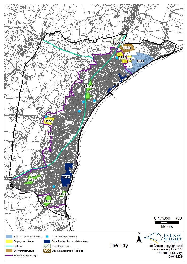
52 52
Strategic Environmental Assessment/ Sustainability Appraisal Non-Technical Summary. Draft for Public Consultation
 South East Lincolnshire Local Plan 2011-2036 Strategic Environmental Assessment/ Sustainability Appraisal Non-Technical Summary Draft for Public Consultation January 2016 Contents 1. INTRODUCTION 3 2.
Item 8: Local Plan Preferred Options
 ITEM 8: Local Plan Preferred Options Purpose of Report a. To seek approval from members of the Core Strategy and Development Management Policies Preferred Options Draft Local Plan document for public consultation.
Winchester District Local Plan Part 2 Development Management and Site Allocations Publication (Pre-Submission) Plan 2015
 Plan 2015") 1 1 Introduction & Background 1.1 The Winchester District Local Plan Part 2 (Development Management and Site Allocations) (LPP2) forms part of the District Development Framework (see below), which will
1 1 Introduction & Background 1.1 The Winchester District Local Plan Part 2 (Development Management and Site Allocations) (LPP2) forms part of the District Development Framework (see below), which will
Babergh & Mid Suffolk Joint Local Plan: Sustainability Appraisal. August 2017
 Babergh & Mid Suffolk Joint Local Plan: Sustainability Appraisal August 2017 Contents NON TECHNICAL SUMMARY... 1 CHAPTER 1 INTRODUCTION... 2 Table 1: Stages of SA/SEA production... 2 Table 2: Statutory
DCLG Consultation on Proposed Changes to National Planning Policy Historic England Submission
 DCLG Consultation on Proposed Changes to National Planning Policy Historic England Submission Historic England is the Government s statutory adviser on all matters relating to the historic environment
Planning for a flourishing Shropshire in the Albrighton Area Local Joint Committee area
 Planning for a flourishing Shropshire in the Albrighton Area Local Joint Committee area This leaflet asks your views on Issues and Options for an important Development Plan Document (DPD), called the Site
Lancaster City Council Corporate Plan
 Lancaster City Council Corporate Plan 2015-2018 2 This page is intentionally blank Contents Our Core Purpose 4 Our Ethos 4 Our Vision 5 Our Priorities: Clean, Green & Safe Places 7 Health & Wellbeing 8
Site Assessment Technical Document
 Central Bedfordshire Council www.centralbedfordshire.gov.uk Site Assessment Technical Document July 2017 1.1.11-1 - ii Table of Contents 1) Introduction... 7 1.1 What is the Site Assessment Technical Document?...
REFERENCE: F/03767/12 Received: 05 October 2012 Accepted: 05 October 2012 WARD(S): West Finchley Expiry: 30 November 2012.
: West Finchley Expiry: 30 November 2012.") LOCATION: 20 Ballards Lane, London, N3 2BJ REFERENCE: F/03767/12 Received: 05 October 2012 Accepted: 05 October 2012 WARD(S): West Finchley Expiry: 30 November 2012 Final Revisions: APPLICANT: PROPOSAL:
LOCATION: 20 Ballards Lane, London, N3 2BJ REFERENCE: F/03767/12 Received: 05 October 2012 Accepted: 05 October 2012 WARD(S): West Finchley Expiry: 30 November 2012 Final Revisions: APPLICANT: PROPOSAL:
Local Government and Communities Committee. Planning (Scotland) Bill. Submission from the Theatres Trust
 Bill. Submission from the Theatres Trust") Local Government and Communities Committee Planning (Scotland) Bill Submission from the Theatres Trust Call for Evidence on the Planning (Scotland) Bill The Theatres Trust welcomes the opportunity to provide
Local Government and Communities Committee Planning (Scotland) Bill Submission from the Theatres Trust Call for Evidence on the Planning (Scotland) Bill The Theatres Trust welcomes the opportunity to provide
SUBMISSION TO THE CONSULTATION ON THE GREATER MANCHESTER SPATIAL FRAMEWORK
 Standish Voice Speaking up for Standish SUBMISSION TO THE CONSULTATION ON THE GREATER MANCHESTER SPATIAL FRAMEWORK Chapter 1 Introduction Question 6: Do you agree that we need a plan for jobs and homes
MHCLG consultation on National Planning Policy Framework March 2018
 MHCLG consultation on National Planning Policy Framework March 2018 The Ministry for Housing, Communities and Local Government (MHCLG) published its draft revisions to the National Planning Policy Framework
Executive Summary. Introduction
 Executive Summary 01 Introduction The City of Southampton lies at the western end of the South Hampshire sub-region. The wider urban South Hampshire area, consisting of Southampton, Eastleigh, Fareham,
ISLAND PLAN. Solent Special Protection Areas. Supplementary Planning Document
 ISLAND PLAN Solent Special Protection Areas Supplementary Planning Document Adopted May 2014 Contents 1. Why a Supplementary Planning Document is required 4 The Solent SPAs... 5 The Isle of Wight Council
Central Farms Estate. Developing a Farm Estate Strategy. Appendix A. Central Bedfordshire Council
 Central Bedfordshire Council www.centralbedfordshire.gov.uk Appendix A Central Farms Estate Developing a Farm Estate Strategy Security classification: Not protected Introduction 1.1 The Council s Farm
GLA Draft Central Activities Zone Supplementary Planning Guidance (Sept 2015) London First Consultation Response
 London First Consultation Response") GLA Draft Central Activities Zone Supplementary Planning Guidance (Sept 2015) London First Consultation Response 8 th December 2015 London First is a business membership organisation with the mission to
GLA Draft Central Activities Zone Supplementary Planning Guidance (Sept 2015) London First Consultation Response 8 th December 2015 London First is a business membership organisation with the mission to
S e c t i o n S u b d i vision
 S e c t i o n 2. 6 - S u b d i vision Subdivision is a process of defining and redefining land parcel boundaries and can provide a framework for future land use and development. Integrated, well planned
Arun District Council. Interim Planning Policy Guidance on Draft for consultation
 Arun District Council Interim Planning Policy Guidance on enterprise@bognorregis Draft for consultation July 2012 Arun District Council Interim Planning Policy Guidance on enterprise@bognorregis DRAFT
ISLAND PLAN. Guidelines for Recycling and Refuse Storage in New Development Consultation Draft Supplementary Planning Document
 ISLAND PLAN Guidelines for Recycling and Refuse Storage in New Development Consultation Draft Supplementary Planning Document November 2016 The consultation process and how to respond Guidelines for Recycling
a. To provide a Vision for south Worcestershire to 2030.
 A New Plan for South Worcestershire Background 66. The SWC have taken the opportunity to develop a long-term plan for south Worcestershire that is based on local economic and housing requirements (covering
BIODIVERSITY AND DEVELOPMENT GUIDANCE FOR HAMPSHIRE
 BIODIVERSITY AND DEVELOPMENT GUIDANCE FOR HAMPSHIRE RECOMMENDATIONS FOR INTEGRATING BIODIVERSITY INTO LOCAL DEVELOPMENT FRAMEWORKS Prepared by Mike Oxford On behalf of the Hampshire Biodiversity Partnership
SUBJECT: LONDON SOUTHEND AIRPORT & ENVIRONS JOINT AREA ACTION PLAN (JAAP) PRE-SUBMISSION PLAN
 PRE-SUBMISSION PLAN") REPORT TO THE MEETING OF THE EXECUTIVE 5 DECEMBER 2012 PORTFOLIO: PORTFOLIO HOLDER FOR PLANNING AND TRANSPORTATION REPORT FROM HEAD OF PLANNING AND TRANSPORTATION SUBJECT: LONDON SOUTHEND AIRPORT & ENVIRONS
REPORT TO THE MEETING OF THE EXECUTIVE 5 DECEMBER 2012 PORTFOLIO: PORTFOLIO HOLDER FOR PLANNING AND TRANSPORTATION REPORT FROM HEAD OF PLANNING AND TRANSPORTATION SUBJECT: LONDON SOUTHEND AIRPORT & ENVIRONS
BUT001: Land to the east of Benington Road, Butterwick Sustainability Objective
 BUT001: Land to the east of Benington Road, Butterwick Sustainability Objective 1. Provide a miture of sustainably designed new housing to provide everybody in South East Lincolnshire with the opportunity
PROPOSED SUBMISSION CONSULTATION SOUTH WORCESTERSHIRE DEVELOPMENT PLAN. On behalf of Land Fund Limited. Our ref: 3471.
 PROPOSED SUBMISSION CONSULTATION SOUTH WORCESTERSHIRE DEVELOPMENT PLAN On behalf of Land Fund Limited Our ref: 3471 January 2013 PROPOSED SUBMISSION CONSULTATION SOUTH WORCESTERSHIRE DEVELOPMENT PLAN CONTENTS
EVIDENCE BASE FOR THE SAHAM TONEY NEIGHBOURHOOD DEVELOPMENT PLAN
 EVIDENCE BASE FOR THE SAHAM TONEY NEIGHBOURHOOD DEVELOPMENT PLAN 2017-2036 VOLUME 13 SUSTAINABILITY STATEMENT Page 1 of 11 TABLE OF CONTENTS 1. BACKGROUND... 3 2. COMPATIBILITY OF THE NEIGHBOURHOOD PLAN
Lincoln - OFFICIAL PLAN PART 1 INTRODUCTION 1.1. THE COMMUNITY VISION
 Lincoln - OFFICIAL PLAN PART 1 INTRODUCTION 1.1. THE COMMUNITY VISION The vision for Lincoln is to be a Centre of Excellence for Agriculture; an inclusive community that values diversity, partnerships,
Peter Wallace 20 th July 2012 Principal Planner Dover District Council Council Offices White Cliffs Business Park Whitfield Dover, CT16 3PJ
 Peter Wallace 20 th July 2012 Principal Planner Dover District Council Council Offices White Cliffs Business Park Whitfield Dover, CT16 3PJ Dear Mr Wallace, Planning Application DOV/12/00440 - Site at
BABERGH DISTRICT COUNCIL and MID SUFFOLK DISTRICT COUNCIL
 BABERGH DISTRICT COUNCIL and MID SUFFOLK DISTRICT COUNCIL From: BDC Cabinet Member Communities MSDC Lead Member Health and Wellbeing To: Babergh and Mid Suffolk Cabinet Report Number: MCa/17/29 Date of
Maidstone Borough Council Draft Local Plan February 2016 Local Plan Regulation 19 Representation from Helen Whately MP
 Maidstone Borough Council Draft Local Plan February 2016 Local Plan Regulation 19 Representation from Helen Whately MP 1. Introduction 1.1. I have read the Maidstone Borough Council (MBC) draft Local Plan
Map 1. Housing Delivery The Black Country Garden City
 Black Country LEP Response to DCLG s Housing White Paper June 2017 Black Country Local Enterprise Partnership: Response to The Department for Communities & Local Government Housing White Paper Fixing our
North Northamptonshire Joint Core Strategy Examination
 North Northamptonshire Joint Core Strategy Examination Joint Position and Delivery Statement By North Northamptonshire Joint Planning Unit, Kettering Borough Council And Persimmon Homes Midlands Policy
Contents. Appendices. 1. List of evidence studies
 Topic Paper: Employment and Town Centre Uses Joint Core Strategy for Broadland, Norwich and South Norfolk November 2009 Contents 1. Summary 1 2. Purpose of this paper 1 3. National and Regional policy
Norfolk Minerals and Waste Local Plan. Sustainability Appraisal Report Non-technical summary
 Norfolk Minerals and Waste Local Plan Minerals Site Specific Allocations Development Plan Document (DPD) Single Issue Silica Sand Review Sustainability Appraisal Report Non-technical summary March 2016
Dunstable Leisure Centre Redevelopment
 Central Bedfordshire Council EXECUTIVE 4 August 2015 Dunstable Leisure Centre Redevelopment Report of Cllr Brian Spurr, Executive Member for Community Services Brian.spurr@centralbedfordshire.gov.uk Advising
WELSH GOVERNMENT. Examination Hearing Statement. Anglesey and Gwynedd Joint Local Development Plan
 WELSH GOVERNMENT Examination Hearing Statement Anglesey and Gwynedd Joint Local Development Plan Hearing Session 1: Plan Preparation, Vision, Objectives & Spatial Strategy 6 th September 2016 (Session
Shaping Housing and Community Agendas
 Chartered Institute of Housing s Response to the Department of Communities and Local Government s Review of the Statutory Duties of Local Authorities April 2011 This consultation response is one of a series
Making use of Planning Policy Statement 12: Local Spatial Planning (PPS12)
") Making use of Planning Policy Statement 12: Local Spatial Planning (PPS12) A CPRE campaign briefing October, 2008 1. In June 2008, the Government published a revised Planning Policy Statement 12: Local
Making use of Planning Policy Statement 12: Local Spatial Planning (PPS12) A CPRE campaign briefing October, 2008 1. In June 2008, the Government published a revised Planning Policy Statement 12: Local
Report by the Executive Director of Community and Environmental Services
 Planning (Regulatory) Committee 1 April 2016 Item No. Applications Referred to Committee for Determination: North Norfolk District: C/1/2015/1025: Hempton: Change of use to a mixed use development to allow
Section 32 Evaluation Report Business Mixed Use Zone (formerly the Business Zone) Contents
 Contents") Section 32 Evaluation Report Business Mixed Use Zone (formerly the Business Zone) Contents Section 32 Evaluation Report: Business Mixed Use Zone (formerly the Business Zone)... 2 1. Strategic Context...
Section 32 Evaluation Report Business Mixed Use Zone (formerly the Business Zone) Contents Section 32 Evaluation Report: Business Mixed Use Zone (formerly the Business Zone)... 2 1. Strategic Context...
FIS001: Land to the east of Lindis Road, Boston Sustainability Objective
 FIS001: Land to the east of Lindis Road, Boston Sustainability Objective Indicative development scenario: Total site area: 7.46ha Potential open space: 0.75ha Development area: 6.71ha Potential no of dwellings:
Transport for the North
 Transport for the North Strategic Transport Plan Integrated Sustainability Appraisal (ISA) Overview 1. Introduction: ISA Purpose, Scope and Process 2. Review of Plans, Policies and Programmes & Baseline
Woking Borough Council. Local Development Documents
 Woking Borough Council Local Development Documents Hot Food Takeaway Supplementary Planning Document October 2014 Produced by the Planning Policy Team For further information please contact: Planning Policy,
ECONOMY BACKGROUND PAPER
 ECONOMY BACKGROUND PAPER OCTOBER 2018 CONTENTS Introduction 3 Legislative and policy context 3 Evidence Base 5 Key Changes 7 Economic Strategy 7 Protection of Industrial Floorspace Capacity 8 Strategic
Revised Local Development Scheme. February 2014
 Revised Local Development Scheme February 2014 1 Contents 1. Introduction... 3 1.1 What is the Local Development Scheme?... 3 1.2 What is the status of this document?... 3 1.3 What is the background and
NORTH WESSEX DOWNS AONB POSITION STATEMENT RENEWABLE ENERGY
 NORTH WESSEX DOWNS AONB POSITION STATEMENT RENEWABLE ENERGY October 2012 1 NORTH WESSEX DOWNS AONB POSITION STATEMENT RENEWABLE ENERGY October 2012 Position Statement Status The purpose behind this Position
Matter 4: Specific Locations Policy - Policy 4 Mitchell Shackleton, Salford (Additional Site SL11)
") 1 Matter 4: Specific Locations Policy - Policy 4 Mitchell Shackleton, Salford (Additional Site SL11) 1. Introduction Entec UK Ltd is acting on behalf of Sky Properties in respect of the omission of Site
1 Matter 4: Specific Locations Policy - Policy 4 Mitchell Shackleton, Salford (Additional Site SL11) 1. Introduction Entec UK Ltd is acting on behalf of Sky Properties in respect of the omission of Site
Transport Assessment Guidelines November 2015 Cambridgeshire County Council
 Transport Assessment Guidelines November 2015 Cambridgeshire County Council Introduction The National Planning Policy Framework (NPPF, March 2012) states that All developments that generate significant
C I T Y R E AC H, K I R K S TA L L ROA D
 C I T Y R E AC H, K I R K S TA L L ROA D P R O P O S A L F O R A M A J O R M I X E D R E S I D E N T I A L C O M M U N I T Y Inhabit are proposing significant investment in Leeds with the regeneration
28 JULY 2015 PLANNING COMMITTEE. 5i 14/1315 Reg d: Expires: Ward: OW. of Weeks on Cttee Day:
 5i 14/1315 Reg d: 25.11.2014 Expires: 29.04.15 Ward: OW Nei. Con. Exp: 14.01.15 BVPI Target Minor (13) Number of Weeks on Cttee Day: 21/8 On Target? No LOCATION: PROPOSAL: TYPE: London House, 134 High
As one of our greatest assets there is a need to take collective action to protect, enhance and value our environment for now and for future
 1 As one of our greatest assets there is a need to take collective action to protect, enhance and value our environment for now and for future generations, ensuring that the Vale of Glamorgan is globally
Ripon City Plan Submission Draft. Supporting Document: Supporting the Ripon Economy. March 2018
 Ripon City Plan Submission Draft Supporting Document: March 2018 Contents 1 Introduction... 1 1.1 Background... 1 2 National Planning Context... 2 2.1 National Planning Policy Framework... 2 2.2 Planning
Almeley Neighbourhood Development Plan (2011 to 2031)
") Almeley Neighbourhood Development Plan (2011 to 2031) CONSULTATION: DRAFT VISION & OBJECTIVES WHAT IS THE ALMELEY NEIGHBOURHOOD DEVELOPMENT PLAN? Neighbourhood Development Plans (NDPs) contain planning
Almeley Neighbourhood Development Plan (2011 to 2031) CONSULTATION: DRAFT VISION & OBJECTIVES WHAT IS THE ALMELEY NEIGHBOURHOOD DEVELOPMENT PLAN? Neighbourhood Development Plans (NDPs) contain planning
Chapter 6 89 The Economy
 Introduction 6.1 Mid Sussex has traditionally enjoyed a healthy and prosperous local economy, and in common with other parts of Central Sussex has experienced considerable economic growth over the last
Central Bedfordshire Local Plan
 Central Bedfordshire Council COUNCIL Thursday 26 April 2018 Central Bedfordshire Local Plan Report of: Cllr Nigel Young, Executive Member for Regeneration (nigel.young@centralbedfordshire.gov.uk) Responsible
Land to the South of Old Mill Road, Sandbach Environmental Impact Assessment Environmental Statement: Non-Technical Summary
 Environmental Impact Assessment Report prepared by: Ecus Ltd. Brook Holt 3 Blackburn Road Sheffield S61 2DW 0114 266 9292 September 2013 Page Left Intentionally Blank 2 INTRODUCTION This Non Technical
Title ISLE OF WIGHT COUNCIL REGENERATION PROGRAMME
 PAPER C Purpose: For Decision Committee EXECUTIVE Date 15 DECEMBER 2016 Title ISLE OF WIGHT COUNCIL REGENERATION PROGRAMME Joint report to LEADER AND EXECUTIVE MEMBER FOR RESOURCES AND CHILDREN S SERVICES
Town & Country Planning Act 1990
 Town & Country Planning Act 1990 Your Ref: 17/0411/OUT Proposed Development at Gwern y Domen by PMG Ltd and Persimmon Homes Ltd I of am against the proposed development for a number of reasons which are
Local Government and Communities Committee. Planning (Scotland) Bill. Submission from Persimmon Homes Limited
 Bill. Submission from Persimmon Homes Limited") Local Government and Communities Committee Planning (Scotland) Bill Submission from Persimmon Homes Limited Persimmon Homes Limited (PHL) welcomes the opportunity to contribute to the Local Government
Local Government and Communities Committee Planning (Scotland) Bill Submission from Persimmon Homes Limited Persimmon Homes Limited (PHL) welcomes the opportunity to contribute to the Local Government
Consultation on MBC Pre Submission Local Plan
 Consultation on MBC Pre Submission Local Plan POSTER 1 Housing Objectives 1. Help provide a stock of housing accommodation that meets the needs of the community, including the need for affordable housing
The New Towns Act 1981 (Local Authority Oversight) Regulations
 Regulations") Briefing 18/29 August 2018 The New Towns Act 1981 (Local Authority Oversight) Regulations To: England For info: Contacts from Scotland, Wales and Northern Ireland. Key Issues Following a consultation in
Briefing 18/29 August 2018 The New Towns Act 1981 (Local Authority Oversight) Regulations To: England For info: Contacts from Scotland, Wales and Northern Ireland. Key Issues Following a consultation in
Swindon Joint Strategic Needs Assessment Bulletin
 Swindon Joint Strategic Needs Assessment Bulletin Bulletin: Economic Strategy Land and Infrastructure Key Points: Capacity constraints on Swindon s road and rail network pose a threat to securing sustainable
REPORT FOR DECISION CABINET COUNCIL DECISION MAKER: 15 NOVEMBER NOVEMBER 2017 DATE:
 REPORT FOR DECISION DECISION MAKER: DATE: SUBJECT: REPORT FROM: CONTACT OFFICER: TYPE OF DECISION: FREEDOM OF INFORMATION/STATUS: CABINET COUNCIL 15 NOVEMBER 2017 29 NOVEMBER 2017 BURY GROWTH PLAN COUNCILLOR
SWDP 4: Moving Around South Worcestershire. SWDP 4: Moving Around South Worcestershire. Managing Travel Demand
 SWDP 4: Moving Around South Worcestershire Managing Travel Demand A. Proposals must demonstrate that: the layout of development will minimise demand for travel, they offer genuinely sustainable travel
Parc Cybi Roadking Hotel. Sequential Assessment Planning Statement Appendix One
 Parc Cybi Roadking Hotel Sequential Assessment Planning Statement Appendix One April 2018 Contents 1. Introduction 2 2. Planning Policy Framework 3 Planning Policy Framework 3 3. Sequential Assessment
MOU001: Land to the west of Eaugate Road, Moulton Chapel Sustainability Objective
 MOU001: Land to the west of Eaugate Road, Moulton Chapel Sustainability Objective Indicative development scenario: Total site area: 0.24ha Potential open space: 0.03ha Development area: 0.21ha Potential
July State Planning Policy. Department of Infrastructure, Local Government and Planning
 July 2017 State Planning Policy Department of Infrastructure, Local Government and Planning The State of Queensland, July 2017. Published by the Department of Infrastructure, Local Government and Planning,
ISLAND PLAN. Guidelines for Recycling and Refuse Storage in New Development. Supplementary Planning Document
 ISLAND PLAN Guidelines for Recycling and Refuse Storage in New Development Supplementary Planning Document January 2017 Page intentionally left blank Guidelines for Recycling and Refuse Storage in New
Brentwood Borough Council. Local Development Plan (LDP): Health Impact Assessment (HIA) (Draft)
: Health Impact Assessment (HIA) (Draft)") Brentwood Borough Council Local Development Plan (LDP): Health Impact Assessment (HIA) (Draft) Table of Contents: 1. Introduction 1.1 Purpose of this report 1.2What is a Local Development Plan 1.3Vision
Brentwood Borough Council Local Development Plan (LDP): Health Impact Assessment (HIA) (Draft) Table of Contents: 1. Introduction 1.1 Purpose of this report 1.2What is a Local Development Plan 1.3Vision
Report to Surrey Heath Borough Council
 Report to Surrey Heath Borough Council by Mike Fox an Inspector appointed by the Secretary of State for Communities and Local Government Date 2 May 2014 PLANNING AND COMPULSORY PURCHASE ACT 2004 (AS AMENDED)
SOUTH CAMBRIDGESHIRE DISTRICT COUNCIL. Joint Planning Directors / Principal Planning Manager, South Cambridgeshire District Council
 SOUTH CAMBRIDGESHIRE DISTRICT COUNCIL REPORT TO: Cambridge City Fringes Joint Committee 28 September 2009 AUTHOR/S: Joint Planning Directors / Principal Planning Manager, South Cambridgeshire District
Involving People in Planning
 Involving People in Planning The Authority s Statement of Community Involvement August 2014 1. Introduction As a National Park Authority we are strongly committed to public involvement in all of our work.
Planning for Future Police Estate Development
 Planning for Future Police Estate Development Guidance for local authorities on the need to make adequate provision through the planning system for police estate development May 2005 Contents Foreword
SOUTH EAST LINCOLNSHIRE LOCAL PLAN: HOUSING PAPER OLD LEAKE (JUNE 2016)
") SOUTH EAST LINCOLNSHIRE LOCAL PLAN: HOUSING PAPER OLD LEAKE (JUNE 2016) 1 OLD LEAKE S PLACE IN THE SPATIAL STRATEGY 1.1 Policy 2 of the South East Lincolnshire Local Plan 2011-2036 Draft for Public Consultation
SOUTH EAST LINCOLNSHIRE LOCAL PLAN: HOUSING PAPER OLD LEAKE (JUNE 2016) 1 OLD LEAKE S PLACE IN THE SPATIAL STRATEGY 1.1 Policy 2 of the South East Lincolnshire Local Plan 2011-2036 Draft for Public Consultation
Appendix B. Chesterfield Borough Council Local Plan. Sustainability Appraisal of Gypsy and Traveller Site Options
 Appendix B Chesterfield Borough Council Local Plan Sustainability Appraisal of Gypsy and Traveller Site Options Non-Technical Summary NTS1 Purpose of this report This document is the Non-Technical Summary
Cork Chamber Submission to the Local Area Plan for Blarney Macroom Municipal District. Cork Chamber BLARNEY-MACROOM LAP Submission
 Cork Chamber BLARNEY-MACROOM LAP Submission Cork Chamber Submission to the Local Area Plan for Blarney Macroom Municipal District 1 INTRODUCTION Introduction & Context Cork Chamber consider it an opportune
CARDIFF CAPITAL REGION CITY DEAL WELL-BEING & EQUALITIES ASSESSMENT
 CARDIFF CAPITAL REGION CITY DEAL WELL-BEING & EQUALITIES ASSESSMENT Description of Proposal: Cardiff Capital Region City Deal Strategic Business Plan for the Wider Investment Fund Section 1) Complete the
Local Plan. Supplementary Planning Document: Delivering Skills, Employment, Enterprise and Training from Development through S106
 Supplementary Planning Document: Delivering Skills, Employment, Enterprise and Training from Development through S106 Page 2 Contents 1. Introduction and policy context... 5 Introduction... 5 Council s
Further information and alternative formats
 Further information and alternative formats If you would like further information or to read this document in a different format such as large print or a different language please contact Planning Policy
LIVERPOOL MUTUAL HOMES GROUP 2015/ /20 CORPORATE PLAN
 LIVERPOOL MUTUAL HOMES GROUP 2015/16 2019/20 CORPORATE PLAN Version v2 January 2016 1 I LIVERPOOL MUTUAL HOMES GROUP CORPORATE PLAN 2015/16-2019/20 Introduction Liverpool Mutual Homes began, in 2008, as
Design and Access Statement in support of the Planning Application for the Victoria Public House, 56 Middlesbrough Road, South Bank, Middlesbrough,
 Design and Access Statement in support of the Planning Application for the Victoria Public House, 56 Middlesbrough Road, South Bank, Middlesbrough, TS6 6LZ, to obtain permission for a Change of Use to
Method of assessment (overview; and assessing significance of effects);
;") 20. Socio-Economics 20.1 This Chapter identifies the significant socio-economic effects likely to occur as a result of the Proposed Development, as detailed in Chapter 5. The assessment considers the socio-economic
20. Socio-Economics 20.1 This Chapter identifies the significant socio-economic effects likely to occur as a result of the Proposed Development, as detailed in Chapter 5. The assessment considers the socio-economic
TWINWOODS WASTE STRATEGY
 TWINWOODS WASTE STRATEGY Prepared by DLP Planning Ltd for Marcol Industrial Investments LLP and Bedfordia Developments Ltd March 2017 TABLE OF CONTENTS INTRODUCTION 1 SITE DESCRIPTION 2 PLANNING POLICY
thinking: BRIEFING 14 Local Development Orders (LDOs) and Simplified Planning Zones (SPZs) August 2011 RELEASE DATE: August 2011
 and Simplified Planning Zones (SPZs) August 2011 RELEASE DATE: August 2011") thinking: BRIEFING 14 Local Development Orders (LDOs) and Simplified Planning Zones (SPZs) August 2011 RELEASE DATE: August 2011 Please direct any questions or comments regarding this paper to: New Economy
thinking: BRIEFING 14 Local Development Orders (LDOs) and Simplified Planning Zones (SPZs) August 2011 RELEASE DATE: August 2011 Please direct any questions or comments regarding this paper to: New Economy
Business and Industrial Areas Queenstown, Frankton, Arrowtown and Wanaka 11.1 Issues, Objectives and Policies
 . Business and Industrial Areas Queenstown, Frankton, Arrowtown and Wanaka.1 Issues, Objectives and.1.1 Resources, Activities and Values Business activities occur throughout the commercial, service and
Managing Change in the Historic Environment: The Use and Adaptation of Listed Buildings
 Managing Change in the Historic Environment: The Use and Adaptation of Listed Buildings Introduction and Purpose of the Document Background Managing Change is a series of guidance notes issued by Historic
GC001: Lambert s Transport/Europa Tyres, Station Road, Gosberton Risegate
 GC001: Lambert s Transport/Europa Tyres, Station Road, Gosberton Risegate Sustainability Objective 1. To provide a mix of sustainably designed new housing to provide everybody in South East Lincolnshire
RACKHEATH NEIGHBOURHOOD PLAN , VERSION 1: PRE-SUBMISSION DRAFT, NOVEMBER 2016
 RACKHEATH NEIGHBOURHOOD PLAN 2017-2037, VERSION 1: PRE-SUBMISSION DRAFT, NOVEMBER 2016 ON BEHALF OF BROADLAND DISTRICT COUNCIL, BARRATT EASTERN COUNTIES & MANOR FARM RACKHEATH 24 11 2016 Version 3 Prepared
Proposed Development Plan Scheme
 Appendix 1 Proposed Development Plan Scheme May 2014 LIVE Park is your chance to really understand the future potential of where you live, work, play and invest. It sets out how planning can help improve
Agenda Item 5. Agenda Item: 5. Local Development Framework Panel Meeting. Page 167. Meeting Date 2 March 2015 Report Title.
 Agenda Item 5 Local Development Framework Panel Meeting Meeting Date 2 March 2015 Report Title Cabinet Member SMT Lead Head of Service Lead Officer Key Decision Classification Forward Plan Recommendations
Detailed Methodology for More Detailed Assessment for Housing Sites. Establishing what capacity re-assessment is required
 B1.5.3 Detailed Methodology for More Detailed Assessment for Housing Sites Paragraphs 4.31 to 4.33 and 4.78 of the SSM advises that further indicative capacity work will be undertaken on each site identified
An outline of the Basic Conditions governing our Plan
 An outline of the Basic Conditions governing our Plan Introduction What follows is a distillation of current central & local government policies that have a bearing on our plan. They may not make exciting
ARE WE ACCESSIBLE TO YOU? IF NOT - ASK US!
 Equality and Diversity Strategy 2017 to 2019 ARE WE ACCESSIBLE TO YOU? IF NOT - ASK US! We want everyone to be able to understand us. We want everyone to be able to read our written materials. We aim to
an Inspector appointed by the Secretary of State for Communities and Local Government
 Appeal Decision Site visit made on 15 December 2017 by S M Holden BSc MSc CEng MICE TPP FCIHT MRTPI an Inspector appointed by the Secretary of State for Communities and Local Government Decision date:
The matrix will record the findings of the assessment by using the following: Score Significance
 Site: Appendix 5.3.4.6 North Tawton Neighbourhood Plan Site Assessment Matrices. Each site considered for allocation within the North Tawton Neighbourhood Plan has been subject to an assessment against
Technical Assessment Testing. Introduction
 B1.6.5 Technical Assessment Testing Introduction This appendix explains the three technical assessments which were undertaken by in September 2017 to consider the implications of District wide distribution
MIXED ACTIVITY ZONE. Chapter 4. Mixed Activity Zone
 Chapter 4 Mixed Activity Zone 4. MIXED ACTIVITY ZONE 4.1 RESOURCE MANAGEMENT ISSUES 1. Activities adjoining main arterial roads can adversely affect the safety, sustainability and efficiency of the network.
1. Government myth: Planning is acting as a serious brake on growth, slowing the delivery of much needed new jobs and new business.
 Problems with the draft National Planning Policy Framework This note has been prepared to assist our members and supporters in responding to the current Government consultation on the draft National Planning
District of Muskoka Official Plan Review (MOPR) TOWARDS ESTABLISHING PLANNING POLICY DIRECTIONS OCTOBER 21, 2016 (REVISED MARCH 6, 2017)
 TOWARDS ESTABLISHING PLANNING POLICY DIRECTIONS OCTOBER 21, 2016 (REVISED MARCH 6, 2017)") District of Muskoka Official Plan Review (MOPR) TOWARDS ESTABLISHING PLANNING POLICY DIRECTIONS OCTOBER 21, 2016 (REVISED MARCH 6, 2017) Page 1 TABLE OF CONTENTS EXECUTIVE SUMMARY... 3 1.0 INTRODUCTION...
District of Muskoka Official Plan Review (MOPR) TOWARDS ESTABLISHING PLANNING POLICY DIRECTIONS OCTOBER 21, 2016 (REVISED MARCH 6, 2017) Page 1 TABLE OF CONTENTS EXECUTIVE SUMMARY... 3 1.0 INTRODUCTION...
Annex. Test Valley Borough Revised Local Plan DPD Schedule of Proposed Main Modifications and Minor Modifications
 Annex Test Valley Borough Revised Local Plan DPD 2011 2029 Schedule of Proposed Main Modifications and Minor Modifications April 2015 Test Valley Borough Revised Local Plan 2011-2029 Schedule of Proposed
Report of Monitoring Officer Author Andrew Weavers Title. North Essex Garden Settlements Project Governance Arrangements
 Cabinet Item 9(i) 27 January 2016 Report of Monitoring Officer Author Andrew Weavers 282213 Title North Essex Garden Settlements Project Governance Arrangements Wards affected All 1. Decisions Required