Dynamic Statewide Water Budget for Water Planning in New Mexico
|
|
|
- Theodora Morton
- 6 years ago
- Views:
Transcription

1 Dynamic Statewide Water Budget for Water Planning in New Mexico


2 Sep Ongoing Drought in New Mexico and the West Jan April July


3 Elephant Butte Storage (AF) Surface supplies diminished by drought 2,000,000 1,600,000 1,200, , ,000 DROUGHT DROUGHT
4 Groundwater drops with less surface water

5 Surface water and groundwater imbalance


6 Fossil water aquifers face consistent declines COLORADO PLATEAUS AQUIFERS BASIN AND RANGE AQUIFERS RIO GRANDE AQUIFER SYSTEM ROSWELL BASIN AQUIFER HIGH PLAINS AQUIFER McGuire, V.L., 2013, Water-level and storage changes in the High Plains aquifer, predevelopment to 2011 and : U.S. Geological Survey Scientific Investigations Report , 15 p.
7 Existing water budgets are were static and imprecise NEW MEXICO MEAN ANNUAL SURFACE WATER BUDGET Inflow 2.4 Million Acre Feet Precipitation 85.3 Million Acre Feet Evaporation 82.0 Million Acre Feet Other Losses 1.1 Million Acre Feet Usable 1.2 Million Acre Feet Groundwater: 20 billion acre-feet 3.0 B fresh, 1.4 B slightly saline recoverable Outflow 3.4 Million Acre Feet
8 The administrative supply is well known RETURN FLOW SURFACE WATER ADMINISTRATIVE SUPPLY ~4.0 GROUNDWATER FLUXES IN MILLION ACRE FEET PER YEAR
9 New Mexico Water Withdrawals (percent of 3,815,944 total) Groundwater withdrawals 1,774,100 acre-feet Surface withdrawals 2,041,844 acre-feet Surface Water Total Groundwater Extraction % Total Agriculture Ground 35.80% Residential Ground, 6.19% Mining Ground 0.80% Commercial Ground 1.68% Livestock Ground 0.96% Domestic Ground Power Livestock 0.76% Ground Mining Commercial Surface 0.30% Surface Surface 0.08% 0.04% 0.09% Agriculture Surface 42.82% Reservoir Evap, 6.87% Power Surface 1.24% Residential Surface 2.13% Irrigated Agriculture Public Water Supply Self-supported Domestic Livestock Commercial / Industrial Mining Power Reservoir Evaporation Longworth, et al New Mexico Water Use by Categories NMOSE Technical Report 54.
10 Total supply is not well known RECHARGE ? RETURN FLOW INFLOW 2.4? SURFACE WATER ADMINISTRATIVE SUPPLY ~4.0 GROUNDWATER PRECIPITATION ? EVAPORATION ? OUTFLOW 3.4? Needed is a comprehensive assessment of New Mexico s water resources to provide a holistic view of New Mexico s water future TOTAL GROUNDWATER STORAGE 20,000? FLUXES IN MILLION ACRE FEET PER YEAR
11 Outputs Inputs Annual Water Fluxes (Millions of Acre-Feet) Groundwater Withdrawals Surface Water Withdrawals MOD-16 ET SSEB ET Need for dynamic assessment of state s water resources Precipitation is highly variable and greatly exceeds total water use Evapotranspiration (ET) consumes most of the precipitation in the state but model estimates are not yet accurate Precipitation data courtesy of : PRISM Climate Group, Oregon State University, created 5 May 2014 Water use data courtesy of : 90, 95, 00- Brian C. Wilson (NM OSE), 05, 10 John Longworth et al (NM OSE) accessed from accessed on 15 May
12 Cutting edge aspects of statewide water budget Dynamic updated within one or two years Comprehensive includes water inputs and outputs Accessible web delivered Science based utilizing latest information

13 NSF NM EPSCOR - Social Natural Science Nexus 13 Objective: Develop a statewide system dynamics model that integrates energy, water, the environment, and human perspectives


14 Social Natural Science Nexus Approach: Build statewide water budget and use as a framework for integrating energy, water, environment, human perspectives Solar to represent renewables Water used for agriculture as part of water budget Beta0 lnoil San Juan Basin Produced oil Fossil fuels NG prod lngas Beta1 Ln_gas employment Ln_population ptrend Ln_oil Ln_income Beta4 SanJuan Basin per capita income Contrib ution of Natural Gas on Employ ment in the San Juan Basin Beta2 lnpop San Juan Basin Pop Time-trend Beta5 Beta3 ln income 14 Systems approach integrating energy and socio economics
15 Systems dynamics modeling Systems dynamics is an approach to model complex systems over time using stocks, fluxes, internal feedbacks and time delays Stocks represent storages Fluxes represent movement into, out of, or between stocks or external sources System dynamics is well suited for accounting- or budget-type models


16 Collaboration for Dynamic Statewide Water Budget Remotely Sensed Evapotranspiration and Precipitation Assessment Oil and Gas Produced Water Assessment Statewide Systems Dynamics Water Budget Groundwater Recharge Assessment Surface Water Flow Statistics Groundwater Level and Storage Changes Water Use Reporting
17 New Mexico Dynamic Statewide Water Budget The dynamic, statewide water budget (DSWB) synthesizes water supply and demand information from across the state into a single, easily accessible location, and in such a way that users can view information at a variety of spatial scales. The DSWB provides a holistic view of water resources in the state, helping to support local and regional education as well as planning, to improve stewardship of New Mexico s limited and critically important water resources.
 33 Counties (thin grey")
18 DSWB spatial scales 7 Major River Basins (black Lines) 16 Water Planning Regions (colored areas) 33 Counties (thin grey lines)
19 NMDSWB Mass Balance Stocks 1. Land Surface- Conceptual representation of soil moisture. The storage in this stock is currently not estimated and changes in storage are assumed to be zero 2. Surface Water- Water flowing in rivers and other natural water ways that can be diverted or impounded for human use. No change in storage through time. At each timestep, the fluxes into and out of this stock are balanced. 1 Land Surface 3 2 Surface Water Human Storage and Distribution Systems 3. Human Storage and Distribution Systems- Water at any given time residing in manmade storage impoundments or distribution systems, such as public water supplies, irrigation canals, and reservoirs. When water is added to storage in a reservoir, it is considered a diversion of available surface water to the human storage system, and when it is released from storage, it is considered a return to the available surface water system. 4. Groundwater- Total groundwater storage is largely unknown except for select aquifers throughout the state. Currently the DSWB does not estimate groundwater storage, but it does track changes in storage over the selected time of a model run. 4 Groundwater
20 SW d GW d ET SW1 SW to GW Precip 3 Recharge SW In 4 7 GW In NMDSWB Mass Balance Fluxes Land Surface ET SW2 Surface Water SW r 6 Human Storage and Distribution Systems GW r 6 Groundwater 6 ET h SW Out 5 3 ET GW 4 GW Out 1. Precipitation- Monthly PRSIM data aggregated for given spatial scale 2. Runoff- Closure term to balance SW stock 3. Sw in /Sw out - USGS stream gage data 4. Gw in /Gw out - Presently unknown terms. Set to zero to allow for calculation of GW storage chage 5. ET GW - Calculation based from USGS NLCD and Hargreaves reference ET estimate 6. Human use- Modeled/ data based human/diversions/consumption/ estimated return flows 7. Recharge- Model assumes steady state GW system on all non-human terms. Recharge = baseflow + ET gw + GW out GWin 8. Landsurface ET- Closure term to balance Land Surface. Landsurface ET = Precip Recharge - Runoff 9. ET SW - Calculation based ET sw2 + estimated ungaged SW return flows 10. SW to GW- Closure term to balance Surface Water System

21 NMDSWB Interface Mass Balance


22 NM statewide water assessment projects DSWB S Precipitation /ET Recharge Groundwater Change Streamflow


23 NM statewide remotely sensed precipitation and evapotranspiration measurements PRISM Precipitation and ET are the largest components of the water balance, yet they are the least accurately measured Validate models using land-based measurements to determine most accurate models for future use in New Mexico


24 Mask irrigated landscape Landsat 8 Imagery Convert Digital Numbers to Top of the Atmosphere Reflectance
 ET, mm/day 6 5 4 3 2 1 0 1 29 57 85 113 141 169 197 225 253 281 309 337 365 Day of Year, 2003")
25 Validation of REEM ET with Satellite and Flux Tower Data ET-Measured ET-REEM (Predicted) ET-REEM (Satellite) ET, mm/day Day of Year, 2003
26 Comparison of ET estimates for Pecans in Mesilla Valley From Remote Sensing, using three different methods


27 GADGET Gridded Atmospheric Data DownscalinG and Evapotranspiration Tools for High-resolution Distributed Reference ET in Complex Terrain Solar radiation topography-based adjustments Using 250 x 250 meter DEM for NM

28 Statewide Recharge Assessment Part of the Statewide Water Assessment, July 2014 Compiled past recharge estimates in different areas of NM Constructed a distributed soil water balance model that estimates diffuse recharge for NM Estimated groundwater recharge from high mountain springs (Chloride Mass Balance)
29 Evapotranspiration and Recharge Model (ETRM) 1D distributed soil water balance model Estimates the partitioning of precipitation into runoff, evaporation, transpiration, and deep percolation Water is stored in three layers of soil, which include stage 1 and stage 2 evaporation layers, and a root zone transpiration layer. The soil water depletion (D) is tracked on a daily time step and recharge occurs when soil moisture exceeds total available water (TAW)

30 Soil Water Balance
 Gabriel Parish is working on improving this")
31 Recharge Map Annual mean diffuse recharge ( ) Focused recharge Esther Xu is working on adding this estimate to the model Total available water (TAW) Gabriel Parish is working on improving this estimate
32 Statewide Water Level Change Analysis Alex Rinehart, Ethan Mamer, Trevor Kludt, Brigitte Felix, Stacy Timmons and Cathryn Pokorny. NM Bureau of Geology. In collaboration with Nathan Myers (USGS) and Mike Johnson (NMOSE) 19 September 2016
33 What We Have Done Producing groundwater storage change estimates over the historical record at decadal time steps for unconfined basin-fill aquifers At HUC-8 spatial scale across New Mexico. We have completed analysis for all of the Rio Grande rift basins and Rio Grande tributaries.

34 How We Did It Review, Find Correlation Length, Intersect Two Decades

35 How We Did It Cut Bedrock, Interpolate, Clip to Correlated Region.

36 What We Found Basin Example
37 What We Found Overall, groundwater storage is dropping. Most confident around populated areas. Least confident in non-irrigated rural regions.

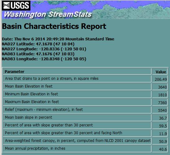

38 USGS New Mexico StreamStats

39 MAJOR ACCOMPLISHMENTS Social Natural Science Nexus Dynamic statewide water budget shows impacts of drought on groundwater storage decline Ongoing work is showing energy cost of pumping groundwater compared to use of gravity-fed surface water 39 NM EPSCoR Site Visit September

40 NMDSWB Interface Human Mass Balance

41 System dynamics participatory modeling
42


43 THANK YOU 43
Planning Beyond the Supply/Demand Gap: Water Supply Vulnerabilities in New Mexico Presented by NM Universities Working Group on Drought
 Planning Beyond the Supply/Demand Gap: Water Supply Vulnerabilities in New Mexico Presented by NM Universities Working Group on Drought 1 Janie Chermak, David Gutzler, Peggy Johnson, J. Phillip King, Lee
Water Availability and Use Science Program. WestFAST September 24, 2015
 Water Availability and Use Science Program WestFAST September 24, 2015 WAUSP Objective To place technical information and tools in the hands of stakeholders, allowing them to answer questions they face
ITRC METRIC and Net Groundwater Use/Recharge
 ITRC METRIC and Net Groundwater Use/Recharge Dan Howes, Ph.D., P.E. 9/5/2018 Irrigation Training and Research Center (ITRC) California Polytechnic State University (Cal Poly) San Luis Obispo, CA 93407
LONG-TERM Animas River GROUNDWATER LEVEL MONITORING after the Gold King Mine 2015 mine-water release
 LONG-TERM Animas River GROUNDWATER LEVEL MONITORING after the Gold King Mine 2015 mine-water release Ethan Mamer Talon Newton Stacy Timmons Cathryn Pokorny NM Bureau of Geology and Mineral Resources A
Groundwater in the Santa Rosa Plain
 . Groundwater in the Santa Rosa Plain Marcus Trotta, PG, CHg Principal Hydrogeologist Sonoma County Water Agency Santa Rosa Plain Groundwater Sustainability Agency October 12, 2017 www.sonomacountywater.org
Improving Economic Returns and Long-Run Sustainability in a Rapidly Growing, Peri- Urban, Multicultural, Small-Scale, Traditional Farming Community
 Improving Economic Returns and Long-Run Sustainability in a Rapidly Growing, Peri- Urban, Multicultural, Small-Scale, Traditional Farming Community Leeann DeMouche Water Resource Specialist New Mexico
A DYNAMIC STATEWIDE WATER BUDGET FOR NEW MEXICO: Phase I - MAJOR RIVER BASINS
 A DYNAMIC STATEWIDE WATER BUDGET FOR NEW MEXICO: Phase I - MAJOR RIVER BASINS Ken Peterson, Water Resources Research Institute Jesse Roach, Tetra Tech Inc. Bruce Thompson, University of New Mexico DRAFT
Irrigation modeling in Prairie Ronde Township, Kalamazoo County. SW Michigan Water Resources Council meeting May 15, 2012
 Irrigation modeling in Prairie Ronde Township, Kalamazoo County SW Michigan Water Resources Council meeting May 15, 2012 Development of a Groundwater Flow Model INFLOWS Areal recharge from precipitation
Grounding Water: An Exploration of the Unseen World Beneath Our Feet
 1 Grounding Water: An Exploration of the Unseen World Beneath Our Feet Kerry Schwartz, Director, Arizona Project WET Protect Your Groundwater Day: Tuesday, September 9, 2014 What I Hope to Convey Groundwater
NEW MEXICO WATER LAW CONFERENCE AUGUST 26 27, Ogallala Aquifer: Where s The Water? By W. Peter Balleau
 NEW MEXICO WATER LAW CONFERENCE AUGUST 26 27, 2002 Ogallala Aquifer: Where s The Water? By W. Peter Balleau Introduction The Ogallala Aquifer is part of the High Plains Aquifer system which is reported
62 nd Annual New Mexico Water Conference
 62 nd Annual New Mexico Water Conference Kenneth (KC) Carroll Plant & Environmental Science Department and Water Science & Management Program kccarr@nmsu.edu Brackish Groundwater Source for Desalination
Northern Arizona Hydrogeology
 Northern Arizona Hydrogeology Some basics Coconino Plateau Hydrogeology Flagstaff and Coconino Plateau Water Resources Well development, City of Flagstaff Effluent discharge to the Rio de Flag from Wildcat
National Water Census Apalachicola Chattahoochee Flint River Basin Focus Area Study
 National Water Census Apalachicola Chattahoochee Flint River Basin Focus Area Study Jacob LaFontaine, Hydrologist USGS South Atlantic Water Science Center October 24, 2014 The USGS National Water Census
The Future of Irrigated Agriculture: Where's the Water?
 The Future of Irrigated Agriculture: Where's the Water? California Colloquium on Water UC Berkley February 9 th 2010 David F. Zoldoske, Director Center for Irrigation Technology California State University,
WATER LEVEL CHANGES IN THE UNCONFINED AQUIFER OF THE SAN LUIS VALLEY,
 WATER LEVEL CHANGES IN THE UNCONFINED AQUIFER OF THE SAN LUIS VALLEY, 1980-1995 By Isobel R. McGowan Shepherd Miller, Inc. 2460 W. 26th Ave., Suite 430-C Denver, CO 80211 and Dan Plazak Consulting Hydrogeologist
Technical Memorandum
 Specialists in Agricultural Water Management Serving Stewards of Western Water since 1993 To: From: Technical Memorandum Butte County Department of Water and Resource Conservation Davids Engineering Date:
California s s Water Supplies and Uses
 California s s Water Supplies and Uses Presented to Delta Stewardship Council Presented by Joe Grindstaff September 21 1 Place to Place: Most precipitation falls in the mountains in the north and east
Chapter 6 Water Resources
 Chapter 6 Water Resources Elemental Geosystems 5e Robert W. Christopherson Charles E. Thomsen 1 Water Resources The Hydrologic Cycle Groundwater Resources Our Water Supply The Hydrologic Cycle A Hydrologic
Examples of Impact of Past Water Management and Geologic Setting on Resilient Water Planning
 Examples of Impact of Past Water Management and Geologic Setting on Resilient Water Planning Alex Rinehart 63rd Annual Water Conference 17-18 October 2018 Future water supply governed by geology and past
May 3, 2011 BUILDING STRONG BUILDING STRONG ALBUQUERQUE DISTRICT. US Army Corps of Engineers. US Army Corps of Engineers
 Upper Rio Grande Water Operations Model Present t& Future Work May 3, 2011 US Army Corps of Engineers US Army Corps of Engineers BUILDING STRONG ALBUQUERQUE DISTRICT URGWOM Website http://www.spa.usace.army.mil/urgwom/default.asp
Context for Central Sands Water Use Trends and Impacts
 Context for Central Sands Water Use Trends and Impacts Wisconsin Food, Land, and Water meeting Wisconsin Rapids, WI November 10, 2016 Kenneth R. Bradbury Wisconsin Geological and Natural History Survey,
GROUNDWATER LEVEL MONITORING along the Animas River, New Mexico, after the Gold King Mine 2015 mine-water release
 GROUNDWATER LEVEL MONITORING along the Animas River, New Mexico, after the Gold King Mine 2015 mine-water release Ethan Mamer Talon Newton Stacy Timmons NM Bureau of Geology and Mineral Resources A Division
CALSIM II Sacramento River Basin Hydrology Enhancements
 CALSIM II Sacramento River Basin Hydrology Enhancements Andy Draper Walter Bourez - Montgomery Watson Harza - MBK Engineers February 26, 2004 Current representation Problems Solutions Work completed Possible
Use and Management of Hydrologic Resources in New Mexico
 Use and Management of Hydrologic Resources in New Mexico Water Work Table Mesa de Trabajo Sobre Agua NEW MEXICO REPORT August, 2006 Utton Transboundary Resources Center University of New Mexico School
Comparative analysis of SWAT model with Coupled SWAT-MODFLOW model for Gibbs Farm Watershed in Georgia
 2018 SWAT INTERNATIONAL CONFERENCE, JAN 10-12, CHENNAI 1 Comparative analysis of SWAT model with Coupled SWAT-MODFLOW model for Gibbs Farm Watershed in Georgia Presented By K.Sangeetha B.Narasimhan D.D.Bosch
Groundwater Policy in the Western U.S University of Idaho Law Review Symposium. Denise D. Fort UNM School of Law
 Groundwater Policy in the Western U.S. 2001 University of Idaho Law Review Symposium Denise D. Fort UNM School of Law fortde@law.unm.edu Outline Groundwater Mining: What is the Policy? A global perspective
CONSTRAINTS ON NEW MEXICO WATER RESOURCE AVAILABILITY by W. Peter Balleau April 30, 1999
 CONSTRAINTS ON NEW MEXICO WATER RESOURCE AVAILABILITY by W. Peter Balleau April 30, 1999 The physical availability of water in New Mexico is over five million acre feet (MAF) per year from streams 1 and
6.0 USGS MODEL. 6.1 Background
 6.0 USGS MODEL 6.1 Background A groundwater flow model is a simplification of a real groundwater flow system. Real groundwater flow systems are complex, and they are often simplified with a model for the
21st Century Climate Change In SW New Mexico: What s in Store for the Gila? David S. Gutzler University of New Mexico
 21st Century Climate Change In SW New Mexico: What s in Store for the Gila? David S. Gutzler University of New Mexico gutzler@unm.edu Silver City, NM June 5, 2008 Global Warming in the 20th/Early 21st
If you need this publication in alternate form, contact the Public Affairs Office at
 If you need this publication in alternate form, contact the Public Affairs Office at 1-800-272-8869. Table of Contents Volume 3 - Regional Reports Chapter 1: State Summary Chapter 2: North Coast Hydrologic
The Hydrological Cycle. Hydrological Cycle. Definition of Terms. Soils and Water, Spring Lecture 7, The Hydrological Cycle 1
 The Hydrological Cycle Water vapor helps warm up the earth Evaporation+Transpiration Chemical Spill Runoff To Oceans Water potential, atmosphere Hydrological Cycle Transpiration, T Atmospheric pool Interception
Role of the State Engineer s Office
 Role of the State Engineer s Office Water Administration Water Court Colorado Water Law: Water Court Practice Seminar March 1, 2018 Kevin Rein, P.E., State Engineer Division of Water Resources Tonight
A Dynamic Statewide Water Budget for New Mexico: Phase III Future Scenario Implementation
 A Dynamic Statewide Water Budget for New Mexico: Phase III Future Scenario Implementation Ken Peterson, Tetra Tech, Inc. Austin Hanson, New Mexico Water Resources Research Institute Jesse Roach, Tetra
Numerical Groundwater Model for the Kaweah Delta Water Conservation District
 Numerical Groundwater Model for the Kaweah Delta Water Conservation District Nels Ruud and Peter Leffler Fugro West, Inc. Larry Dotson Kaweah Delta Water Conservation District Presentation Outline Background
Ottawa County Water Resources Study Phase 2
 Ottawa County Water Resources Study Phase 2 Overview David P. Lusch, Ph.D. Department of Geography and Institute of Water Research Michigan State University 1 / 24 Ottawa County Planning and Performance
1 THE USGS MODULAR MODELING SYSTEM MODEL OF THE UPPER COSUMNES RIVER
 1 THE USGS MODULAR MODELING SYSTEM MODEL OF THE UPPER COSUMNES RIVER 1.1 Introduction The Hydrologic Model of the Upper Cosumnes River Basin (HMCRB) under the USGS Modular Modeling System (MMS) uses a
To address water supply issues in the San Acacia
 CURRENT ISSUES ON THE MIDDLE RIO GRANDE 89 How Science Can Provide Pathways to Solutions The Technical Toolbox Susan Kelly, Utton Transboundary Resources Center, University of New Mexico School of Law
A Proposed Approach to Sustainable Groundwater Extraction Based on Surface- Groundwater Interaction
 A Proposed Approach to Sustainable Groundwater Extraction Based on Surface- Groundwater Interaction Mike Tietze, PG, CEG, CHG, Jacobson James & Associates Bob Abrams, Ph.D., PG, CHG, Jacobson James & Associates
Modeling Shallow Groundwater for Support of Riparian Areas in the Colorado River Delta
 Modeling Shallow Groundwater for Support of Riparian Areas in the Colorado River Delta Matthew R. Grabau, PhD, Karen J. Schlatter, Eliana Rodríguez Burgueño, Jorge Ramírez Hernández, PhD, Jeff Milliken,
Stream hydrographs. Stream hydrographs. Baseflow. Graphs of river stage or discharge at a single location as a function of time
 Stream hydrographs Graphs of river stage or discharge at a single location as a function of time Hydrologic og budget Discharge: units? How is it measured? Show fluctuating water levels in response to
GROUND WATER/STJRFACE WATER INTERACTIONS JULY 1-5 AWRA SUMMER SPECIALTY CONFERENCE
 1997) GROUND WATER/STJRFACE WATER INTERACTIONS JULY 1-5 AWRA SUMMER SPECIALTY CONFERENCE 2002 Surface Water - Groundwater Interaction Represented in the Rio Grande Water Resources Planning Model I 2 Edward
Groundwater Resources Program Regional Groundwater Evaluation
 Groundwater Resources Program Regional Groundwater Evaluation Appalachian Plateaus Aquifer System Kurt McCoy, David Nelms Mark Kozar Richard Yager David Ladd USGS Virginia Water Science Center USGS West
Water Budgets. 1. Recap of Groundwater What is required for a water budget? 3. How will water budgets be used in GSPs? 4. Factors to consider
 Water Budgets 1 Water Budgets 1. Recap of Groundwater 1.0 2. What is required for a water budget? 3. How will water budgets be used in GSPs? 4. Factors to consider 5. Practice! 2 Conceptual Water Budget
General Groundwater Concepts
 General Groundwater Concepts Hydrologic Cycle All water on the surface of the earth and underground are part of the hydrologic cycle (Figure 1), driven by natural processes that constantly transform water
Watersheds. A river is the report card for its watershed. Alan Levere. Arizona Water Issues 2010 The University of Arizona HWR203 1
 Watersheds A river is the report card for its watershed. Alan Levere 1 What separates watersheds? How do you identify watershed boundaries? Drainage Divides River Networks boto.ocean.washington.edu/gifs/purus.gif
Physically-based Distributed Hydrologic Modeling
 Physically-based Distributed Hydrologic Modeling Goal of Phys.-based Distrib. Hydrologic Modeling To date we have learned about: Key forcings at land surface (precipitation/net radiation) Physical processes
Draft White Paper on Total Water Use. Submitted to: Buena Vista Water Storage District
 Draft White Paper on Total Water Use Submitted to: Buena Vista Water Storage District Date: February 2016 Table of Contents 1.0 Introduction 2 2.0 Role of Accounting for Total Water Use in SGMA 2 2.1 Consumptive
Adaption to climate change: New technologies for water management and impact assessment
 Adaption to climate change: New technologies for water management and impact assessment Wim Bastiaanssen Director WaterWatch (NL) Professor at Delft University of Technology (NL) Some selected problems
CHAPTER 7 GROUNDWATER FLOW MODELING
 148 CHAPTER 7 GROUNDWATER FLOW MODELING 7.1 GENERAL In reality, it is not possible to see into the sub-surface and observe the geological structure and the groundwater flow processes. It is for this reason
Comparison of Streamflow and Precipitation in the Upper Provo River Watershed
 Comparison of Streamflow and Precipitation in the Upper Provo River Watershed By: Steven McKee CEE 6440 GIS in Water Resources Final Project 12/6/2012 0 Table of Contents Introduction... 2 Methods to Determine
Climate Impacts and Water Sources in the Riparian Zone James Hogan
 Climate Impacts and Water Sources in the Riparian Zone James Hogan NSF STC for Sustainability of Semi-Arid Hydrology and Riparian Areas (SAHRA) Department of Hydrology and Water Resources College of Engineering
Characterizing Groundwater and Surface- Water Interactions in Selected Northeast Twin Cities Lakes
 Characterizing Groundwater and Surface- Water Interactions in Selected Northeast Twin Cities Lakes Chapter A: Statistical Analysis and Field Study Chapter B: Groundwater-Flow Simulation Perry M. Jones,
Western Groundwater: A Status Report and a Look Ahead
 Western Groundwater: A Status Report and a Look Ahead Dr. Leonard F. Konikow Scientist Emeritus, U.S. Geological Survey Reston, VA University of Colorado Getches-Wilkinson Center for Natural Resources,
Water Resources of Central Iron County and Washington County
 Water Resources of Central Iron County and Washington County An Alternative to the Lake Powell Pipeline Project Jesse Pope Instructor: Dr. Tarboton CEE 6440 2013 2 Table of Contents INTRODUCTION....3 Figure
Calibrating the Soquel-Aptos PRMS Model to Streamflow Data Using PEST
 Calibrating the Soquel-Aptos PRMS Model to Streamflow Data Using PEST Cameron Tana Georgina King HydroMetrics Water Resources Inc. California Water Environmental and Modeling Forum 2015 Annual Meeting
Estimating Groundwater Recharge within Wisconsin s Central Sands
 Estimating Groundwater Recharge within Wisconsin s Central Sands Adam Freihoefer and Robert Smail Wisconsin Department of Natural Resources [study objective] Identify a defensible approach to quantify
BAEN 673 / February 18, 2016 Hydrologic Processes
 BAEN 673 / February 18, 2016 Hydrologic Processes Assignment: HW#7 Next class lecture in AEPM 104 Today s topics SWAT exercise #2 The SWAT model review paper Hydrologic processes The Hydrologic Processes
Perspectives on the Nation s Ground- Water Availability. William M. Alley Sioux Falls October 30, 2007
 Perspectives on the Nation s Ground- Water Availability William M. Alley Sioux Falls October 30, 2007 Principal Aquifers of the United States Source: Ground Water Atlas of the United States http://capp.water.usgs.gov/gwa/
Embedded Energy in Water Studies Study 1: Statewide and Regional Water-Energy Relationship
 Embedded Energy in Water Studies Study 1: Statewide and Regional Water-Energy Relationship Prepared by GEI Consultants/Navigant Consulting, Inc. Prepared for the California Public Utilities Commission
U.S. Geological Survey (USGS) Florida Water-Use Program
 Florida Water-Use Program") U.S. Geological Survey (USGS) Florida Water-Use Program By Richard L. Marella Florida Water Science Center - Orlando U.S. Department of the Interior U.S. Geological Survey USGS Florida Water-Use Program
U.S. Geological Survey (USGS) Florida Water-Use Program By Richard L. Marella Florida Water Science Center - Orlando U.S. Department of the Interior U.S. Geological Survey USGS Florida Water-Use Program
South Platte Decision Support System Alluvial Groundwater Model Update Documentation
 EXECUTIVE SUMMARY Prepared for The Colorado Water Conservation Board and Division of Water Resources South Platte Decision Support System Alluvial Groundwater Model Update Documentation June 2017 All cover
Projected Impacts of Climate Change on Water Resources in the Upper Rio Grande Basin
 Projected Impacts of Climate Change on Water Resources in the Upper Rio Grande Basin Presentation to the New Mexico Academy of Science, New Mexicans for Science and Reason, and the NM Museum of Natural
Lower Rio Grande Salinity Monitoring
 Lower Rio Grande Salinity Monitoring Chad Johannesen, DBS&A Beiling Liu, NM Interstate Stream Commission James F. Hogan, NM Environment Department Amy Ewing, DBS&A Chris Wolf, DBS&A Rio Grande Surface
Effects of land use change on the water resources of the Basoda basin using the SWAT model
 INDIAN INSTITUTE OF TECHNOLOGY ROORKEE Effects of land use change on the water resources of the Basoda basin using the SWAT model By Santosh S. Palmate* 1 (Ph.D. Student) Paul D. Wagner 2 (Postdoctoral
Hydrogeology of Prince Edward Island
 Hydrogeology of Prince Edward Island General Characteristics and Groundwater on Prince Edward Island General Characteristics and Key Issues Issues PEI Dept. of Environment, Energy and Forestry 9/29/2009
GROUND WATER/SURFACE WATER INTERACTIONS AWRA SUMMER SPECIALTY CONFERENCE Judith Schenk'
 July 1-3 GROUND WATER/SURFACE WATER INTERACTIONS AWRA SUMMER SPECIALTY CONFERENCE 2002 326x6 pjf= INTEGRATION OF DATA USING GIS AND STATEPP TO ESTIMATE GROUNDWATER MODEL INPUT PARAMETERS Judith Schenk'
Rockland County s Water Resources -Selected Findings from the USGS Study- Paul M. Heisig, Hydrologist New York USGS Water Science Center Troy, NY
 Rockland County s Water Resources -Selected Findings from the USGS Study- Paul M. Heisig, Hydrologist New York USGS Water Science Center Troy, NY Subject to Permits Water Sources Rockland County, NY -Lake
Third Consequence: Drought/Surface Water Shortages Fourth Consequence: Decline of Groundwater & Underground Flows
 Third Consequence: Drought/Surface Water Shortages Fourth Consequence: Decline of Groundwater & Underground Flows Water Assembly March 21, 2015 J. Phillip King, P.E., Ph.D. Professor and Associate Department
Predicting Groundwater Sustainability: What Tools, Models and Data are Available?
 Predicting Groundwater Sustainability: What Tools, Models and Data are Available? Ray Wuolo Barr Engineering Company Assessing Sustainability is All About: Predicting (or describing) how potentiometric
Mapping Groundwater Recharge Rates Under Multiple Future Climate Scenarios in Southwest Michigan
 http://mi.water.usgs.gov/reports/images/cover_med01_4227.jpg Mapping Groundwater Recharge Rates Under Multiple Future Climate Scenarios in Southwest Michigan Glenn O Neil Institute of Water Research Michigan
A Simple Irrigation Scheduling Approach for Pecan Irrigation in the Lower Rio Grande Valley
 ABSTRACT A Simple Irrigation Scheduling Approach for Pecan Irrigation in the Lower Rio Grande Valley Zhorab Samani, Salim Bawazir, Max Bleiweiss, Rhonda Skaggs, John Longworth, Aldo Piñon,Vien Tran Submitted
What makes the Great Salt Lake level go up and down?
 What makes the Great Salt Lake level go up and down? Tarboton, David G. 1. Mohammed, Ibrahim N. 1. Lall, Upmanu 2. Utah Water Research Laboratory, Utah State University, Logan, Utah 1. Earth & Environmental
Issue paper: Aquifer Water Balance
 Issue paper: Aquifer Water Balance 1. Introduction And Background 1.1. Purpose and Scope The population in Kitsap County has grown rapidly in recent years and is expected to increase substantially in the
Understanding the Water System
 W Water Is a Natural Resource Understanding the Water System Cost WATER QUALITY in KENTUCKY The Water Cycle Figure 1. Trends in Water Withdrawals and Population, 1950 to 1995. Millions of People/Billion
EL PASO COUNTY WATER REPORT
 EL PASO COUNTY WATER AUTHORITY EL PASO COUNTY WATER REPORT DRAFT Executive Summary The El Paso County Water Authority (EPCWA) has prepared this Water Report to assist in evaluating how water demands of
Quantification of lake water level influences for Wawasee and Syracuse lakes: Lake and watershed water budgets for 2011, 2012, and 2013
 Quantification of lake water level influences for Wawasee and Syracuse lakes: Lake and watershed water budgets for 2011, 2012, and 2013 Nathan S. Bosch, Joellyn Moine, Margaret Lee, Anna Burke Center for
12/11/2014. Provided by Thomas Harter, UC Davis RAIN. How much groundwater is in an aquifer?
 12/11/2014 Drought Effects on Groundwater Management: Understanding Groundwater, Drought, and Streams Overview 1. Differences in aquifer characteristics across California ag areas (capacity, material,
Assessment of Groundwater Resources in the South Platte Basin, CO
 Assessment of Groundwater Resources in the South Platte Basin, CO Christopher J. Ruybal, Terri S. Hogue, John E. McCray Civil and Environmental Engineering, Colorado School of Mines, 1500 Illinois Street,
SALINAS VALLEY GROUNDWATER BASIN SETTING INITIAL REVIEW FOR DEVELOPMENT OF GROUNDWATER SUSTAINABILITY PLAN
 1 SALINAS VALLEY GROUNDWATER BASIN SETTING INITIAL REVIEW FOR DEVELOPMENT OF GROUNDWATER SUSTAINABILITY PLAN May 10, 2018 Prepared for Salinas Valley Basin Groundwater Sustainability Agency Outline Purpose
Arkansas Basin Roundtable: Basin Implementation Plan Section 3:Basin Operations & Hydrologic Modeling
 Arkansas Basin Roundtable: Basin Implementation Plan Section 3:Basin Operations & Hydrologic Modeling March 12, 2014 Outline Project Tasks Basin Implementation Plan (Section 3) Basin Operations Report
Determining Surface Water Availability in Oregon: Program Overview and Updates
 Determining Surface Water Availability in Oregon: Program Overview and Updates Jordan Beamer, OWRD Mellony Hoskinson, OWRD Ken Stahr, OWRD AWRA Meeting Portland, OR 11/9/2017 Figures: OWRD, 2012 Water
The Downstream Perspective
 The Downstream Perspective Chris C. Mahannah, PE, SWRS 12 February 2018 Lyon / Churchill County Water Workshop Mahannah & Associates, LLC chris@mah2o.com (775) 323-1804 Speakers Chris Mahannah, P.E. downstream
AGENDA DATE: November 14, 2018
 ALAMEDA COUNTY FLOOD CONTROL AND WATER CONSERVATION DISTRICT, ZONE 7 100 NORTH CANYONS PARKWAY, LIVERMORE, CA 94551 PHONE (925) 454-5000 FAX (925) 454-5727 ORIGINATING SECTION: INTEGRATED PLANNING CONTACT:
Denver Basin Aquifers in El Paso County
 Denver Basin Aquifers in El Paso County Colorado Division of Water Resources Administer Water Rights Water Commissioners, River and Reservoir Operations, Division and Assistant Division Engineers Issue
Rio Grande Project Operating Agreement: Supplemental Environmental Assessment
 Rio Grande Project Operating Agreement: Supplemental Environmental Assessment Jim Wilber Albuquerque Area Office Bert Cortez El Paso Field Division August 2, 2013 Project Operations: 1916-1979 From Project
Depletion of Aquifer Levels in the Lower Rio Grande
 Depletion of Aquifer Levels in the Lower Rio Grande New Mexico Supercomputing Challenge Final Report April 4, 2012 Team 37 Desert Academy Team Members: Jeremy Hartse Taylor Bacon Teachers: Jocelyne Comstock
The Use of Models for Water Administration In Colorado
 The Use of Models for Water Administration In Colorado AWSE 89 th Annual Meeting September 26, 2016 Springdale, Utah Dick Wolfe, M.S., P.E. State Engineer 1 Presentation Scope Areas of model use Colorado
Report. Environmental Water Demands. Butte County Department of Water and Resource Conservation Integrated Water Resources Plan.
 Report Butte County Department of Water and Resource Conservation Integrated Water Resources Plan s June 2004 s Section 1 - Introduction 1.1 Project Description This project is a preliminary investigation
Amy Settemeyer, Manager, Watermaster Section WATER RIGHTS MANAGEMENT IN TEXAS
 Amy Settemeyer, Manager, Watermaster Section WATER RIGHTS MANAGEMENT IN TEXAS TOPICS FOR TODAY Water Rights Management Watermaster Areas Non-watermaster Areas (TCEQ Regional Offices) Watermaster Evaluations
Investigation of the Coastal Lowlands Aquifer System
 Investigation of the Coastal Lowlands Aquifer System Michael Bradley, Linzy Foster, and Brian Clark U.S. Geological Survey Alabama Water Resources Conference and Symposium Sept 7-9, 2016 The information
Sterling and Gilcrest/LaSalle High Groundwater Analysis
 FINAL REPORT Prepared for The State of Colorado, Department of Natural Resources Sterling and Gilcrest/LaSalle High Groundwater Analysis July 2015 Sterling and Gilcrest/LaSalle High Groundwater Analysis
Climate Change and Drought Scenarios for Water Supply Planning
 Climate Change and Drought Scenarios for Water Supply Planning Analyses of the sensitivity of water availability (surface water and groundwater) and water demand to climate change and drought will be conducted
SLIDES: South Metro Denver Water Supply Study
 University of Colorado Law School Colorado Law Scholarly Commons Groundwater in the West (Summer Conference, June 16-18) Getches-Wilkinson Center Conferences, Workshops, and Hot Topics 6-18-2004 SLIDES:
Drainage Water Recycling Managing Water for Tomorrow s Agriculture
 Drainage Water Recycling Managing Water for Tomorrow s Agriculture Jane Frankenberger, Professor & Ben Reinhart, Project Manager Agricultural & Biological Engineering Purdue University Crops need water.
Utilization of the SWAT Model and Remote Sensing to Demonstrate the Effects of Shrub Encroachment on a Small Watershed
 Utilization of the SWAT Model and Remote Sensing to Demonstrate the Effects of Shrub Encroachment on a Small Watershed Jason Afinowicz Department of Biological and Agricultural Engineering Texas A&M University
LEGAL AND PHYSICAL CONSTRAINTS ON THE CONJUNCTIVE USE WATER SUPPLY OF THE MIDDLE RIO GRANDE REGION
 LEGAL AND PHYSICAL CONSTRAINTS ON THE CONJUNCTIVE USE WATER SUPPLY OF THE MIDDLE RIO GRANDE REGION Deborah L. Hathaway 1, Kevin G. Flanigan 2, Karen J. Lewis 3 ABSTRACT: Conjunctive use of surface water
DEPARTMENT OF GEOGRAPHY POST GRADUATE GOVT. COLLEGE FOR GIRLS.SECTOR-11 CHANDIGARH CLASS-B.A.II PAPER-A RESOURCES AND ENVIRONMENT: WORLD PATTERNS
 DEPARTMENT OF GEOGRAPHY POST GRADUATE GOVT. COLLEGE FOR GIRLS.SECTOR-11 CHANDIGARH CLASS-B.A.II PAPER-A RESOURCES AND ENVIRONMENT: WORLD PATTERNS Hydrological cycle The sun, which drives the water cycle,
2017 GROUNDWATER DISCHARGE AND USAGE
 2017 GROUNDWATER DISCHARGE AND USAGE 2018 2017 Groundwater Discharge and Usage Groundwater discharges from the Edwards Aquifer either as springflow or as pumping from wells. Comal and San Marcos springs,
Analysis and Simulation of Conjunctive Water Use for Agricultural Settings with the Farm Process for MODLFOW
 Analysis and Simulation of Conjunctive Water Use for Agricultural Settings with the Farm Process for MODLFOW Randy Hanson 1, and Wolfgang Schmid 2 1 U.S. Geological Survey 2 University of Arizona Resource
The Hydrologic Cycle (with emphasis on groundwater)
") The Hydrologic Cycle (with emphasis on groundwater) The Hydrologic Cycle (viewed in series of steps) 1. Water evaporates from bodies of surface water and from land 2. As moist air is lifted, it cools and
The Hydrologic Cycle (with emphasis on groundwater) The Hydrologic Cycle (viewed in series of steps) 1. Water evaporates from bodies of surface water and from land 2. As moist air is lifted, it cools and