Estimating the Seasonal High Water Table: A Mix of Art & Science
|
|
|
- Karin Shelton
- 6 years ago
- Views:
Transcription
1 Estimating the Seasonal High Water Table: A Mix of Art & Science PONDS WORKSHOP - SJRWMD Devo Seereeram, Ph.D., P.E. This paper was originally written over 4 years ago & generated a lot of interest. The approach described in this paper is now being used by SWFWMD in their training workshops and is now recognized as acceptable by the NRCS (see attached letter).
2 What is the SHWT? SHWT = Seasonal High Water Table P A seasonal high water table (SHWT) is the shallowest depth to free water that stands in an unlined borehole or where the soil moisture tension is zero for a significant period (more than a few weeks) (Watts and Hurt, 1991). P According to Rule 40C-42, Florida Administrative Code, the seasonal high groundwater table (SHWT) elevation means the highest level of the saturated zone in the soil in a year with normal rainfall. P Groundwater professionals are routinely called upon by site grading and drainage engineers and other professionals to predict these groundwater elevations, typically to within an accuracy of ±6 inches
3 What is the Starting Point? P Although the published sources of information (such as the NRCS publications) generally provide reliable preliminary guidance on the depth to the water table at a site, there is no substitute for a sitespecific investigation for design level studies. P The starting point is the measurement of the stabilized groundwater level in a newly opened borehole, or piezometer at a selected location and time. A stabilized reading, in this sense, means that the water level in the newly created borehole or well has equalized with the water table level in the aquifer. A minimum of 24 hours is usually allowed before taking a reading, although sandy soils require less time than silty or clayey soils to achieve equilibrium levels. P The date of the water table measurement is very important and must be recorded since the groundwater table fluctuates throughout the year in response to seasonal rainfall. In addition, the soil profile in the test hole or boring should be described, noting soil texture (i.e., sand, silty sand, "hardpan", clayey sand, etc.), color (including mottling and staining, more formally known as redoximorphic features), and, if available, Standard Penetration Test boring "N" values variations which may manifest memory of the seasonal fluctuation.
4 How do we adjust from the starting point? P Antecedent rainfall (short-term as well as long-term) P Soil map unit descriptions published by the United States Department of Agriculture (USDA) Natural Resources Conservation Service (NRCS) P Examination of the soil profile, including color variations (redoximorphic features), SPT "N" values, depth to "hardpan" or other impermeable horizons (such as clayey fine sands and clays), etc. P Consistency of water levels with adjacent surface water bodies and knowledge of typical hydraulic gradients (water table slopes). P Vegetative indicators P Effects of existing and future development P Hydrogeologic setting including potentiometric surface of Floridan aquifer and degree of connection between the water table aquifer and the Floridan aquifer. P Mathematical Correlation With Soil Morphological Features
5 ANTECEDENT RAINFALL can run continuous simulation
6 Hydrology of the Uppermost Aquifer A Key Point To Note It is first important to appreciate that, under natural conditions, the rate of lateral groundwater movement in the uppermost water table aquifer in Central Florida is no more than 300 to 400 feet per year and usually much less. Therefore, a water particle entering the water table aquifer at one end of a site may take several years before it exits the downgradient boundary of the site or discharges into a surface water body within the site. The reaction of the water table within a wet season, spanning typically about 4 months (June through September), is therefore not controlled signficantly by lateral groundwater inflows and outflows to the prism or by conditions which exist greater than a lateral distance of 300 to 400 feet.
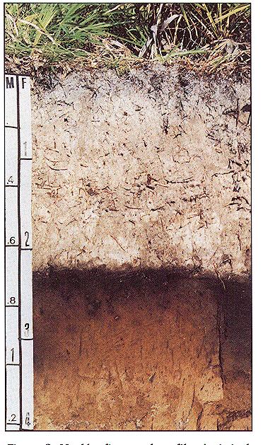
7 Longest Continuous Seasonal High Water Table Investigation in the State of Florida
8 Estimating SHWT - The NRCS Methods REDOXIMORPHIC FEATURES P NRCS procedure is based solely on morphology; i.e., identifying mottles and low chroma colors in a soil horizon which form by processes related to saturation and reduction of iron. These processes may be actively occuring during the year or have occured in the horizon at some time in the past. P Soil mottling patterns can also be relicts of past moisture regimes. P NRCS maps are on a scale of 1:20000 and are not a substitute for on-site investigations. Experience indicates that the NRCS estimates of SHWT are reliable in areas where recent development or long-term hydrogeologic changes have not influenced the shallow groundwater flow regime. P NRCS data should always be reviewed as part of the water table evaluation.
9

10 SHWT determination in E horizon of Spodsoils ( Soils with hardpan) Chroma 1 no organic matter accumulation around root SHWT area where chroma 1 & 2 are mixed Chroma 2 organic matter accumulation around root

11 Sandy Soil no mottles

12 Sandy Soil - few mottles not indicative of SHWT

13 Sandy Soil Common iron bright colored mottles, indicative of SHWT

14 Sandy Soil - many iron bright colored mottles indicative of SHWT

15 Loamy soil: gray at ped surfaces Indicative of SHWT
16 CORRELATION TO TYPICAL GRADIENTS
17 VEGETATIVE INDICATORS
18 BURIED PALEOSINKS - ORANGE GROVE AERIALS
19 IMPACTS OF DEVELOPMENT
PART 1b. Section 7.2 of SJRWMD Special Publication SJ93-SP10
 PART 1b GEOTECHNICAL INVESTIGATION TO ESTIMATE AQUIFER PARAMETERS Note the word is estimate & not determine. Must appreciate the physical meaning of each aquifer parameter. Aquifer, in this sense, does
PART 2D. Section 7.2 of SJRWMD Special Publication SJ93-SP10
 PART 2D GEOTECHNICAL INVESTIGATION TO ESTIMATE AQUIFER PARAMETERS Note the word is estimate & not determine. Must appreciate the physical meaning of each aquifer parameter. Aquifer, in this sense, does
GEOTECHNICAL INVESTIGATION & ASSESSMENT TO ESTIMATE AQUIFER PARAMETERS
 GEOTECHNICAL INVESTIGATION & ASSESSMENT TO ESTIMATE AQUIFER PARAMETERS SJRWMD PONDS WORKSHOP! Note the word is estimate & not determine! Must appreciate the physical meaning of each aquifer parameter!
August 15, 2006 (Revised) July 3, 2006 Project No A
 July 3, 2006 Project No A") August 15, 2006 (Revised) July 3, 2006 Project No. 01-05-0854-101A Mr. David Reed, P.E. Protean Design Group 100 East Pine Street, Suite 306 Orlando, Florida 32801 Preliminary Soil Survey Report Polk Parkway
August 15, 2006 (Revised) July 3, 2006 Project No. 01-05-0854-101A Mr. David Reed, P.E. Protean Design Group 100 East Pine Street, Suite 306 Orlando, Florida 32801 Preliminary Soil Survey Report Polk Parkway
HYDRIC SOILS. By Neal Svendsen Resource Soil Scientist Natural Resources Conservation Service Sept 2006
 HYDRIC SOILS By Neal Svendsen Resource Soil Scientist Natural Resources Conservation Service Sept 2006 Wetlands and Hydric Soils The term hydric soils proposed by Cowardin in 1979 Classification of Wetlands
Report of Preliminary Geotechnical Engineering Investigation for Ponds
 Report of Preliminary Geotechnical Engineering Investigation for Ponds Segment 2: State Road 400 (SR 400)/Interstate 4 (I-4) from West of SR 528 (Beachline Expressway) to West of SR 435 (Kirkman Road)
Soil, Landscape, Hydrology Relationships
 Soil, Landscape, Hydrology Relationships Soil Hydrologic Cycle Unsaturated Soils with Suction (Tension) Forces Water under a suction, pulls particles together. This water is not free water, it is not free
Continuous Simulation Modeling of Stormwater Ponds, Lakes, & Wetlands: A BUILT-IN APPLICATION OF PONDS 3.2
 Continuous Simulation Modeling of Stormwater Ponds, Lakes, & Wetlands: A BUILT-IN APPLICATION OF PONDS 3.2 PRESENTED AT THE SFWMD WORKSHOP PRE-DEVELOPMENT VERSUS POST DEVELOPMENT RUNOFF VOLUME ANALYSIS
PREDEVELOPMENT VERSUS POSTDEVELOPMENT VOLUME ANALYSIS: An Application of Continuous Simulation Modeling using PONDS Version 3 Software
 PREDEVELOPMENT VERSUS POSTDEVELOPMENT VOLUME ANALYSIS: An Application of Continuous Simulation Modeling using PONDS Version 3 Software PRESENTATION TO: SOUTH FLORIDA WATER MANAGEMENT DISTRICT RFP No. C-8501
Report of Preliminary Geotechnical Engineering Investigation for Ponds
 Report of Preliminary Geotechnical Engineering Investigation for Ponds Segment 3: State Road 400 (SR 400)/Interstate 4 (I-4) from One Mile East of SR 434 to East of SR 15-600/US 17-92 Seminole County (77160),
Wetland Delineation. Richard L. Darden, Ph.D. U.S. Army Corps of Engineers Charleston District October 3, 2012 BUILDING STRONG
 Wetland Delineation Richard L. Darden, Ph.D. U.S. Army Corps of Engineers Charleston District October 3, 2012 Why Delineate Wetlands? To define the limits of federal jurisdiction, in accordance with current
November 2007 DRAFT Appendix E: Soil Testing Criteria
 November 2007 DRAFT Appendix E: Soil Testing Criteria Stormwater management design is dependent upon the changes that occur between pre and postdevelopment conditions. The impacts are assessed based on
4. GEOTECHNICAL FIELD INVESTIGATION SUMMARY
 Rev. 0 Date: AUGUST 18, 2012 Project.: COUVA CHILDREN S HOSPITAL - COUVA, TRINIDAD Page 29 Title: EISL-412-DD-TR-2012 PRELIMINARY GEOTECHNICAL FEASIBILITY REPORT 4. GEOTECHNICAL FIELD INVESTIGATION SUMMARY
September 9, Corzo Castella Carballo Thompson Salman, P.A. 901 Ponce de Leon Boulevard Suite 900 Coral Gables, Florida 33134
 September 9, 2009 Corzo Castella Carballo Thompson Salman, P.A. 90 Ponce de Leon Boulevard Suite 900 Coral Gables, Florida 3334 Attn: Mr. Ian John, E.I. Re: Exfiltration Test Results Glenroyal East Phase
A-2. Soils. Soil Media. Chapter Contents. Soil Media In-situ Soil Testing Separation from Seasonal High Water Table (SHWT)
") A-2. Soils Chapter Contents Soil Media In-situ Soil Testing Separation from Seasonal High Water Table (SHWT) Importance of Soil Composition in SCMs The soil composition of many stormwater SCMs also is
A-2. Soils Chapter Contents Soil Media In-situ Soil Testing Separation from Seasonal High Water Table (SHWT) Importance of Soil Composition in SCMs The soil composition of many stormwater SCMs also is
CONDUCTED FOR: PREPARED FOR: 18 October 2010 YPC Project No. 10GY133
 GEOTECHNICAL EXPLORATION AND ENGINEERING SERVICES REPORT CONDUCTED FOR: Immokalee Stormwater Master Plan Implementation Immokalee, Collier County, Florida PREPARED FOR: Mr. Marc Stonehouse, P. E. Project
The C horizon, where encountered, is shale or marl or stratified layers of shale, marl and clay.
 is commonly silty clay or clay and less commonly silty clay loam or clay loam. Reaction ranges from moderately acid to slightly alkaline and is typically noncalcareous. The Ck or C horizon has colors in
Soil Class Handouts Greeley Colorado October 22 & 23, 2015
 Soil Class Handouts Greeley Colorado October 22 & 23, 2015 1. Hand Texturing Flow Chart 2. Table 10-1 Soil Treatment Area Long Term Acceptance Rates by Soil Texture, Soil Structure, Percolation Rate and
Redoximorphic Features
 Redoximorphic Features Redoximorphic Features for Identifying Aquic Conditions, Technical Bulletin 301 NCSU, Raleigh, North Carolina. Order from: Dept. of Ag. Comm., Box 7603, NCSU, Raleigh, NC 27695-7603
Determination of Design Infiltration Rates for the Sizing of Infiltration based Green Infrastructure Facilities
 Determination of Design Infiltration Rates for the Sizing of Infiltration based Green Infrastructure Facilities 1 Introduction This document, developed by the San Francisco Public Utilities Commission
Source of Pollution or Groundwater Solution?
 Acknowledgement Source of Pollution or Groundwater Solution? Kitt Farrell-Poe, Ph.D. Water Quality Extension Specialist & Professor Agricultural & Biosystems Engineering University of Arizona This work
Applicant s Handbook, Volume II (including Appendices A through F`) is Incorporated by Reference in Rule , F.A.C.
 is Incorporated by Reference in Rule , F.A.C.") REFERENCES AND DESIGN AIDS FOR THE ENVIRONMENTAL RESOURCE PERMIT APPLICANT S HANDBOOK VOLUME II FOR USE WITHIN THE GEOGRAPHIC LIMITS OF THE NORTHWEST FLORIDA WATER MANAGEMENT DISTRICT Applicant s Handbook,
REFERENCES AND DESIGN AIDS FOR THE ENVIRONMENTAL RESOURCE PERMIT APPLICANT S HANDBOOK VOLUME II FOR USE WITHIN THE GEOGRAPHIC LIMITS OF THE NORTHWEST FLORIDA WATER MANAGEMENT DISTRICT Applicant s Handbook,
Flow-Through Lake/Wetland: Generalized Monitoring Strategy
 General Hydrologic Characteristics of Flow-Through Lakes & Wetlands Flow-through lakes are surface expressions of the water table and are in direct hydraulic connection with the water-table aquifer. They
Private Sewage Permit Application
 Kneehill County 1600-2 Street NW Three Hills, AB T0M 2A0 Phone: 403-443-5541 Fax: 403-443-5115 Private Sewage Permit Application Permit Number Permit Type: Owner Contractor Development Permit Number: Application
Groundwater 3/16/2010. GG22A: GEOSPHERE & HYDROSPHERE Hydrology
 GG22A: GEOSPHERE & HYDROSPHERE Hydrology Definitions Groundwater Subsurface water in soil or rock that is fully saturated. Aquifer Contains enough saturated material to yield significant quantities of
Subsurface Environmental Investigation
 Subsurface Environmental Investigation Lake Development East Lake and 21 st Avenue South February 23, 201 Terracon Project No. MP14738A Prepared for: Minneapolis Public Schools Prepared by: Terracon Consultants,
REFERENCES AND DESIGN AIDS FOR ENVIRONMENTAL RESOURCE PERMIT APPLICANT S HANDBOOK VOLUME II
 REFERENCES AND DESIGN AIDS FOR ENVIRONMENTAL RESOURCE PERMIT APPLICANT S HANDBOOK VOLUME II FOR USE WITHIN THE GEOGRAPHIC LIMITS OF THE NORTHWEST FLORIDA WATER MANAGEMENT DISTRICT Applicant s Handbook,
The Relationship between the Properties and Features of Wetland Soils and the Adjacent Uplands
 The Relationship between the Properties and Features of Wetland Soils and the Adjacent Uplands By USDA Natural Resources Conservation Service Connecticut Staff Wetlands and watercourses are features of
RELATIONSHIPS BETWEEN SOIL MORPHOLOGY AND WATER TABLE LEVELS. Mark H. Stolt and Charles P. Morgan
 RELATIONSHIPS BETWEEN SOIL MORPHOLOGY AND WATER TABLE LEVELS Mark H. Stolt and Charles P. Morgan Acknowledgements USEPA National Community Decentralized Wastewater Treatment Demonstration Project Block
Soil Physical Properties and Wastewater Treatment
 Soil Physical Properties and Wastewater Treatment John R. Buchanan, Ph.D., P. E. Associate Professor Biosystems Engineering and Soil Science Department Soil Physical Properties and Wastewater Treatment
 Appendix A - Vicinity Map Vicinity Map: Palm Beach Gardens City Hall Additions, 000 N Military Trail, Palm Beach Gardens, FL Proposed Location of Police Dept. Attached Addition Proposed Location of New
ORLANDO SANFORD INTERNATIONAL AIRPORT OUTPARCEL 6 SANFORD, FLORIDA
 PRELIMINARY GEOTECHNICAL STUDY ORLANDO SANFORD INTERNATIONAL AIRPORT OUTPARCEL 6 SANFORD, FLORIDA November 9, 2015 Prepared For: Ms. Diane H. Crews, A.A.E. Sanford Airport Authority 1200 Red Cleveland
Urban Soil Conservation and Management
 Urban Soil Conservation and Management Urban Soil include those located in: Cities in park areas Recreation areas Community gardens Green belts Lawns Septic absorption fields Sediment basins We need a
HYDROLOGIC CRITERION FOR HYDRIC SOILS. M. J. Vepraskas, NC State University
 HYDROLOGIC CRITERION FOR HYDRIC SOILS M. J. Vepraskas, NC State University Is this a hydric soil? Yes, because it meets the definition of a hydric soil. Definition A hydric soil is a soil that formed under
ORLANDO SANFORD INTERNATIONAL AIRPORT OUTPARCEL 1 SANFORD, FLORIDA
 PRELIMINARY GEOTECHNICAL STUDY ORLANDO SANFORD INTERNATIONAL AIRPORT OUTPARCEL 1 SANFORD, FLORIDA November 9, 2015 Prepared For: Ms. Diane H. Crews, A.A.E. Sanford Airport Authority 1200 Red Cleveland
Recharge Lake/Wetland: Generalized Monitoring Strategy
 General Hydrologic Characteristics of Recharge Lakes & Wetlands The primary sources of water for recharge lakes and wetlands are direct precipitation and surface runoff. The lake stage of a recharge lake
Understanding Groundwater in Land Treatment Systems.
 Understanding Groundwater in Land Treatment Systems. Katie Beecroft 1, Hamish Lowe 1 and Erin Ganley 2 1 Lowe Environmental Impact Limited, PO Box 4667, Palmerston North 2 Horowhenua District Council,
Soil Characteristics. 3. Subsoil Consistence Class - In addition to topsoil depth, consistency of the subsoil layer has been
 Soil quality is an all important factor in forest management decisions. Soils influence which tree species will grow best and yield the highest timber product volume, the length of time required to grow
CHESAPEAKE BAY PRESERVATION AREA PROGRAM CHESAPEAKE BAY PRESERVATION AREAS
 6.1 OVERVIEW CHESAPEAKE BAY PRESERVATION AREAS Virginia s Chesapeake Bay Preservation Area Designation and Management Regulations (9VAC10-20 et seq.) require local governments to implement ordinances designed
Deep River-Portage Burns Waterway Watershed 2015
 2.4 Soils Soil development is the product of the interaction of parent material, topography, climate, organisms and time. Understanding the types of soils that exist within a watershed and their characteristics
May 2, Mr. Tim Kurmaskie, AIA ARCHITECT KURMASKIE ASSOCIATES, INC Washington Street Raleigh, NC
 Mr. Tim Kurmaskie, AIA ARCHITECT KURMASKIE ASSOCIATES, INC. 1030 Washington Street Raleigh, NC 27605-1258 May 2, 2017 Re: Report of Subsurface Investigation Westfield Rehabilitation & Health Care Additions
Preliminary Soil Survey Report
 Florida Department of TRANSPORTATION Preliminary Soil Survey Report Malabar Road (SR 514) PD&E Study From East of Babcock Street (SR 507) to US 1 Brevard County, Florida FPID: 430136 1 22 01 ETDM: 13026
Groundwater Mounding Causes, Issues and Prevention
 Groundwater Mounding Causes, Issues and Prevention WCOWMA - Onsite Wastewater Association of BC 2017 Annual Convention and Tradeshow March 11, 2017 Presented by Daniel Watterson, P.Geo., LHG Watterson
Effect of Land Surface on Runoff Generation
 Effect of Land Surface on Runoff Generation Context: Hydrologic Cycle Runoff vs Infiltration Infiltration: Process by which water on the ground surface enters the soil Runoff: Water (from rain, snowmelt,
Hydrologic Engineering Center Hydrologic Modeling System (HEC-HMS) Sunil KUMAR Director, National Water Academy
 Sunil KUMAR Director, National Water Academy") Hydrologic Engineering Center Hydrologic Modeling System (HEC-HMS) Sunil KUMAR Director, National Water Academy 22 April 2015 NWA, Pune Exercise Objective: To determine hydrological Response of the given
Hydrologic Engineering Center Hydrologic Modeling System (HEC-HMS) Sunil KUMAR Director, National Water Academy 22 April 2015 NWA, Pune Exercise Objective: To determine hydrological Response of the given
REPORT OF GEOTECHNICAL EXPLORATION WEST MARJORY AVENUE TAMPA, FLORIDA
 REPORT OF GEOTECHNICAL EXPLORATION WEST MARJORY AVENUE TAMPA, FLORIDA AREHNA PROJECT NO. B-15-008 March 11, 2015 Prepared For: City of Tampa Stormwater Division 306 W. Jackson Street, 6N Tampa, Florida
An Explanation of the Hydric Soil Technical Standard and Normal Precipitation
 An Explanation of the Hydric Soil Technical Standard and Normal Precipitation From: National Technical Committee for Hydric Soils. 2001. Hydric Soil Technical Standard (Technical Note 11). http://soils.usda.gov/soil_us
Components Used: Septic Tank; Size Lagoon Packaged Sewage Treatment Plant Holding Tank; Size
 June 2016 Permit Issuance Please contact Lac Ste. Anne County at: 4928 Langston Street; Box 219 Sangudo, AB T0E 2A0 Ph. 780.785.3411 or Fax 780.785.2985 www.lsac.ca Email: devassistant@lsac.ca Inspection
Hydrologic Soil Group Knowledge Matrix
 Hydrologic Soil Group Knowledge Matrix Refinement Of Soils Parameter For MPCA s Minimum Impact Design Standards Calculator and Stand-Alone Hydrologic Soil Group Determination Funding for this project was
Agronomy 406 World Climates
 Agronomy 406 World Climates February 13, 2018 Hydrologic cycle. Team 4 Climate News presentation this Thursday. Review: METED module, Understanding the Hydrologic Cycle Active review session for the midterm
This report presents the findings of the subsurface exploration concerning the design of the taxiway rehabilitation. Description
 September 22, 2016 American Infrastructure Development, Inc. 3810 Northdale Boulevard, Suite 170 Tampa, Florida 33624 Attn: Mr. Mohsen Mohammadi, Ph.D., P.E. Senior Consultant Mob: (813) 244-6609 E-mail:
100% Report of Geotechnical Engineering Investigation CENTRAL FLORIDA COMMUTER RAIL TRANSIT SUNRAIL PHASE 2 SOUTH Poinciana Vehicle Storage & Light
 100% Report of Geotechnical Engineering Investigation CENTRAL FLORIDA COMMUTER RAIL TRANSIT SUNRAIL PHASE 2 SOUTH Poinciana Vehicle Storage & Light Maintenance Facility (VSLMF) Osceola County, Florida
Preliminary Geotechnical Engineering Report
 Preliminary Geotechnical Engineering Report Phases I and II BV-4B Dredged Material Management Area (DMMA) Brevard County, Florida December 8, 2014 Terracon Project No. HB145006 Prepared for: Taylor Engineering,
Gravity driven dewatering systems for landfill expansion
 Waste Management and the Environment IV 183 Gravity driven dewatering systems for landfill expansion S. A. Smith. & J. A. Smyth Richardson Smith Gardner and Associates, Inc, USA Abstract A landfill site
Hydrologic Indicators
 Hydrologic Indicators Courtney M. Stevens Regulatory Specialist Coastal Branch December 8, 2011 US Army Corps of Engineers HYDROLOGY Some Factors that Influence the Wetness of a Site Climate Landscape
Background Information on the. Peace River Basin
 Background Information on the Peace River Basin Resource Conservation & Development Department August 24 Background Physiography The Peace River drainage basin occupies large parts of Polk, Hardee, DeSoto,
Groundwater and Base Flow BMPs BMPs for Nitrogen Removal in Marion County
 Groundwater and Base Flow BMPs BMPs for Nitrogen Removal in Marion County September 9, 2016 Evan Shane Williams, Ph.D., P.E. Marion County Office of the County Engineer Marion County is home to three First
Stormwater Management Studies in Areas Undergoing Reconstruction Following the Tornado that Hit Tuscaloosa, AL
 Stormwater Management Studies in Areas Undergoing Reconstruction Following the Tornado that Hit Tuscaloosa, AL Redahegn Sileshi, Robert Pitt 2, Shirley Clark 3, and Chad Christian 4 PhD Candidate, The
Soil Water Relationship. Dr. M. R. Kabir
 CHAPTER 4 Soil Water Relationship Dr. M. R. Kabir Professor and Head, Department of Civil Engineering University of Asia Pacific (UAP), Dhaka LECTURE 10 Introduction Root zone (depth of soil penetrated
Merrill Crescent Septic Assessment, Lot 106, Merrill Rd., Madeira Park
 K.E.R. Enterprises Inc 920 Garden Bay Rd Garden Bay BC V0N 1S1 June 19,2017 Merrill Crescent Septic Assessment, Lot 106, Merrill Rd., Madeira Park Condition of Existing Septic Field: 1. Eight one hundred
Commonwealth of Massachusetts City/Town of Form 11 - Soil Suitability Assessment for On-Site Sewage Disposal. Street Address Map/Lot #
 A. Facility Information Owner Name Street Address Map/Lot # City State Zip Code B. Site Information 1. (Check one) New Construction Upgrade Repair 2. Published Soil Survey Available? Yes No If yes: Year
Gaining Stream: Generalized Monitoring Strategy
 General Hydrologic Characteristics of Gaining Streams Most stream reaches in the metro area are gaining reaches (i.e. the stream flow increases in the downstream direction due to inflow of groundwater).
Remediation of Brine Spills- What Goes Wrong Kerry Sublette
 Remediation of Brine Spills- What Goes Wrong Kerry Sublette University of Tulsa Spills of produced water or brine on soil result in two types of damage: Excess salinity Creates an osmotic imbalance that
Application of Mulch Biowall for Anaerobic Treatment of Perchlorate in Shallow Groundwater
 Paper G-04, in: G.B. Wickramanayake and H.V. Rectanus (Chairs), In Situ and On-Site Bioremediation 2009. Tenth International In Situ and On-Site Bioremediation Symposium (Baltimore, MD; May 5 8, 2009).
BAEN 673 / February 18, 2016 Hydrologic Processes
 BAEN 673 / February 18, 2016 Hydrologic Processes Assignment: HW#7 Next class lecture in AEPM 104 Today s topics SWAT exercise #2 The SWAT model review paper Hydrologic processes The Hydrologic Processes
Northeastern Illinois
 Groundwater Recharge in Northeastern Illinois NE Illinois Regional Water Supply Planning Committee April22 22, 2008 Belvidere, IL Donald A. Keefer, P.G. Director Geologic Mapping & Hydrogeology Center,
WESTERN UPPER PENINSULA HEALTH DEPARTMENT RESIDENTIAL ON-SITE SEWAGE PROGRAM ALTERNATIVE TECHNOLOGY POLICY
 1 WESTERN UPPER PENINSULA HEALTH DEPARTMENT RESIDENTIAL ON-SITE SEWAGE PROGRAM ALTERNATIVE TECHNOLOGY POLICY Subject: Residential On-Site Sewage Program Date: June 15, 2001 Alternative Technology Policy
Standards for Soil Erosion and Sediment Control in New Jersey May 2012 STANDARD FOR GRASSED WATERWAYS. Definition. Purpose
 STANDARD FOR GRASSED WATERWAYS Definition A natural or constructed watercourse shaped or graded in earth materials and stabilized with suitable vegetation for the safe conveyance of runoff water. Purpose
Numerical Groundwater Flow Model Report. Caloosa Materials, LLC 3323 Gulf City Road Ruskin, Florida 33570
 Numerical Groundwater Flow Model Report Caloosa Materials, LLC 3323 Gulf City Road Ruskin, Florida 33570 GHD 2675 Winkler Ave Suite 180 Fort Myers, FL 33901 11138224 Report July 27, 2017 Table of Contents
Continuing Education Course #209 Green Irrigation Fundamentals Balancing Aquifer Recharge and Withdrawal
 1 of 7 Continuing Education Course #209 Green Irrigation Fundamentals Balancing Aquifer Recharge and Withdrawal 1. The balanced irrigation water demand is based mainly on (hint: water created by the improvements):
Appendix 10-A. Optional Recharge Volume Approach
 Appendix 10-A Optional Recharge Volume Approach Table of Contents APPENDIX SECTION HEADINGS 10-A.0 INTRODUCTION 10-A-2 10-A.1 Horsely Method for Determining Recharge Volumes 10-A-2 10-A.1.1 Basis for Determining
TABLE OF CONTENTS. 5.0 LABORATORY TESTING Corrosion Series Testing Consolidation Testing... 5
 TABLE OF CONTENTS 1.0 SITE AND PROJECT DESCRIPTION... 1 2.0 NRCS SOIL SURVEY... 1 3.0 USGS POTENTIOMETRIC MAP DATA... 2 4.0 SUBSURFACE EXPLORATION... 3 4.1 SPT Borings... 3 4.2 Groundwater Measurement...
WinTR-55 Small Watershed Hydrology
 WinTR-55 Small Watershed Hydrology Modeling Single Sub-area Watersheds (Part 2) We ve looked at the minimum data entry requirements and how we can enter curve numbers and times of concentration directly
16.0 Water Quality Management Criteria for Developed Land
 October 2003, Revised February 2005 Criteria for Developed Land Page 1 16.1 Introduction 16.0 Water Quality Management Criteria for Developed Land Stormwater quality control is an integral part of any
DYNFLOW accepts various types of boundary conditions on the groundwater flow system including:
 Section 6 Groundwater Flow Model A groundwater flow model was developed to evaluate groundwater flow patterns in the site area and to provide a basis for contaminant transport modeling. 6.1 Model Code
Stormwater Retention Pond Recovery Analysis
 Stormwater Retention Pond Recovery Analysis By Nicolas E Andreyev The first in a series of courses on Green Drainage Design www.suncam.com Page 1 of 33 Forward To design a stormwater retention pond, one
Storage and Flow of Groundwater
 Storage and Flow of Groundwater Aquifer AQUIFER (in Greek)= AQUA (water) + FERRE (to bear) Aquifer- a saturated geological formation which will yield sufficient quantity of water to wells and springs Underground
Permeable Pavement: A New Chapter
 Permeable Pavement: A New Chapter Annette Lucas, PE (919) 807-6381 annette.lucas@ncdenr.gov NC Division of Water Quality Wetlands & Stormwater Branch Final Chapter Released: October 16, 2012 We Bring Engineering
Background. AEM Tier 2 Worksheet Farmstead Water Supply Evaluation. AEM Principle: Glossary
 AEM Tier 2 Worksheet Glossary Casing: Steel or plastic pipe installed while drilling a well, to prevent collapse of the well bore hole and the entrance of contaminants, and to allow placement of a pump
Mineral Hydric Soil Morphology Part 1 of 2
 Mineral Hydric Soil Morphology Part 1 of 2 Ch. 7 Richardson & Vepraskas Outline: 1. Redox Reactions and Associated Soil Conditions 2. Principal Types of Morphological Features in Hydric Soils September
Ponds: planning, design, and construction
 Ponds: planning, design, and construction Ponds for many purposes: Fish Production Recreation Water Supply Esthetics Wildlife Habitat Natural ponds: Formed in natural depressions in the landscape Not man-made
Dewatering Fly Ash for Remediation: Two Approaches
 2015 World of Coal Ash (WOCA) Conference in Nasvhille, TN - May 5-7, 2015 http://www.flyash.info/ Dewatering Fly Ash for Remediation: Two Approaches Gregory M. Landry, P.E. Moretrench American Corporation,
Design and Operation of Landfills
 Design and Operation of Landfills Soils and hydrogeology Site selection criteria Site layout and landfill operations Liner design Water balance Biological reactions in landfills Leachate quality Gas production
Climate Change and Its Potential Effect on Vernal Pool Ecosystems: Example of Oregon & California Hardpan Vernal Pools
 Climate Change and Its Potential Effect on Vernal Pool Ecosystems: Example of Oregon & California Hardpan Vernal Pools Presented by Niall McCarten Overview Vernal Pool Wetlands brief overview Climate atmospheric
APPENDIX C Site Evaluation Checklists
 APPENDIX C Site Evaluation Checklists C-1 GENERAL Water Management analysis and design for airfields are based on a variety of site data for both the existing condition and the proposed project(s). The
Seepage and Conveyance Technical Feedback Group Meeting. March 31, 2016
 Seepage and Conveyance Technical Feedback Group Meeting March 31, 2016 (recap of February 12, 2016 Meeting) Agenda Introductions Purpose Operational Decision Making Almond Study Phase 1 Response to Comments
On-site Systems and Groundwater Washington State Department of Health February 6, 2014
 On-site Systems and Groundwater Washington State Department of Health February 6, 2014 1 Nancy Darling, LHG, CPSS Office of Shellfish and Water Protection Key Groundwater Considerations Type and strength
Evaluating Potential Effects of Development on Southern Ontario Wetlands
 Evaluating Potential Effects of Development on Southern Ontario Wetlands Latornell Conservation Symposium November 20 th 2014 Andrea Bradford, Ph.D., P.Eng. School of Engineering W E T L A N D L O S SE
Investigation of a Floodplain Pond to Improve Alluvial Aquifer Sustainability: A Quantity and Quality Report
 Investigation of a Floodplain Pond to Improve Alluvial Aquifer Sustainability: A Quantity and Quality Report Water Resources Investigation Report 16 i P a g e Investigation of a Floodplain Pond to Improve
Discharge Lake/Wetland: Generalized Monitoring Strategy
 Discharge Lake/Wetland: Generalized Monitoring Strategy General Hydrologic Characteristics of Discharge Lakes & Wetlands Discharge lakes and wetlands are in direct hydraulic connection with the water-table
Seepage and Conveyance Technical Feedback Group Meeting. March 2, Preliminary draft subject to change
 Seepage and Conveyance Technical Feedback Group Meeting March 2, 2017 Patti Ransdell INTRODUCTION 2 Agenda Introductions, Meeting Agenda SJRRP Updates January 23 Meeting Recap Capillary Fringe Buffer,
Michigan Criteria for On-Site Wastewater Treatment ~~~~~~~
 Michigan Criteria for On-Site Wastewater Treatment ~~~~~~~ Edit 12/21/2011 Table of Contents Introduction Chapter 1 Administration, Purpose, and Applicability 1.1 Administration 1.2 Purpose 1.3 Applicability
VIRGINIA POLLUTION ABATEMENT (VPA) PERMIT APPLICATION. FORM B - ANIMAL FEEDING OPERATIONS (AFOs)
 PERMIT APPLICATION. FORM B - ANIMAL FEEDING OPERATIONS (AFOs)") VIRGINIA POLLUTION ABATEMENT (VPA) PERMIT APPLICATION FORM B - ANIMAL FEEDING OPERATIONS (AFOs) Department of Environmental Quality Rev. 02-2013 VIRGINIA POLLUTION ABATEMENT (VPA) PERMIT APPLICATION FORM
VIRGINIA POLLUTION ABATEMENT (VPA) PERMIT APPLICATION FORM B - ANIMAL FEEDING OPERATIONS (AFOs) Department of Environmental Quality Rev. 02-2013 VIRGINIA POLLUTION ABATEMENT (VPA) PERMIT APPLICATION FORM
Imagine the result. Primary Bottom Ash Pond - CCR Groundwater Monitoring Well Network Evaluation. American Electric Power Service Corporation
 Imagine the result American Electric Power Service Corporation Primary Bottom Ash Pond - CCR Groundwater Monitoring Well Network Evaluation J. Robert Welsh Power Plant 1187 County Road 4865 Titus County
Mapping of the Basseterre Valley Aquifer
 Mapping of the Basseterre Valley Aquifer Coastal Aquifer Management in Caribbean SIDS Workshop, St. Kitts-Nevis Halla Sahely, Ph.D., P.Eng St. Kitts Water Services Department October 11, 2010 Participating
CCR RULE GROUNDWATER MONITORING CERTIFICATION COAL ASH PONDS ELMER SMITH STATION DAVIESS COUNTY OWENSBORO, KENTUCKY
 CCR RULE GROUNDWATER MONITORING CERTIFICATION COAL ASH PONDS ELMER SMITH STATION DAVIE COUNTY OWENSBORO, KENTUCKY Prepared For: OWENSBORO MUNICIPAL UTILITIES OWENSBORO, KENTUCKY Prepared By: CIVIL & ENVIRONMENTAL
S.R. 430, Segment 250 Offset 0000, Greenfield Township Wetland Delineation
 S.R. 430, Segment 250 Offset 0000, Greenfield Township Wetland Delineation Date: October 30, 2007 Re: To: From: Erie County SR 430 Segment 250 Offset 0000 Wetland Delineation Mr. Todd Palmer Bridge Unit
LAKE LABELLE ENGINEERING REPORT
 154 N. Bridge Street, LaBelle, Florida 33935 -Tel: (863) 612-0011 Fax: (863) 612-0014 - email: rock@rockhendry.com LAKE LABELLE ENGINEERING REPORT PREPARED FOR Lake LaBelle, LLC March 2014 PREPARED BY:
Appendix I. Potential Adverse Change to Wetland Function Methodology and Results
 Appendix I Potential Adverse Change to Wetland Function Methodology and Results Technical Memorandum North Florida Regional Water Supply Plan Potential Adverse Change to Wetland Function January 3, 2017
A STUDY OF GROUNDWATER POLLUTION VULNERABILITY USING DRASTIC/GIS, WEST BENGAL, INDIA
 JOURNAL OF ENVIRONMENTAL HYDROLOGY The Electronic Journal of the International Association for Environmental Hydrology On the World Wide Web at http://www.hydroweb.com VOLUME 8 2000 A STUDY OF GROUNDWATER