2D flood modelling: coping with real world applications
|
|
|
- Juliet Leonard
- 6 years ago
- Views:
Transcription
1 2D flood modelling: coping with real world applications Dr Vasilis Bellos CH2M, Experienced Researcher Marie Curie fellow
2 Introduction Flooding is a natural hazard of great importance Improving the accuracy of simulation 1D approach dominant choice in practice weakness in complexities of real world 2D approach feasible option the last two decades computational burden (hours/days)
3 Aspects of modelling Friction modelling Representation of buildings Boundary conditions Source and sink terms Calibration Uncertainties
4 FLOW-R2D model Fortran 90/95 language 2D Shallow Water Equations (2D-SWE) Finite Difference Method Modification of McCormack numerical scheme Non-staggered, cell-centred grid Wet/dry modelling Urban environments Catchment scale

5 Friction modelling Manning Darcy-Weisbach Chézy
6 Friction modelling
7 Friction modelling homogeneous computational domains discharge in steady state Zone Roughness (mm) Parameters A B C Silt Concrete Untreated shot-concrete Rubble masonry Asphalt Fine sand Coarse sand Sand Fine gravel Medium coarse gravel Very coarse gravel Coarse gravel Gravel Cobble


8 Friction modelling A=2.596 B=10.0 C=0.1 heterogeneous computational domains Tous dam break
9 Representation of buildings Solid boundaries (free-slip or no-slip) Local elevation rise Local increase of friction Solid boundaries better option Model performance Computational time Added uncertainty
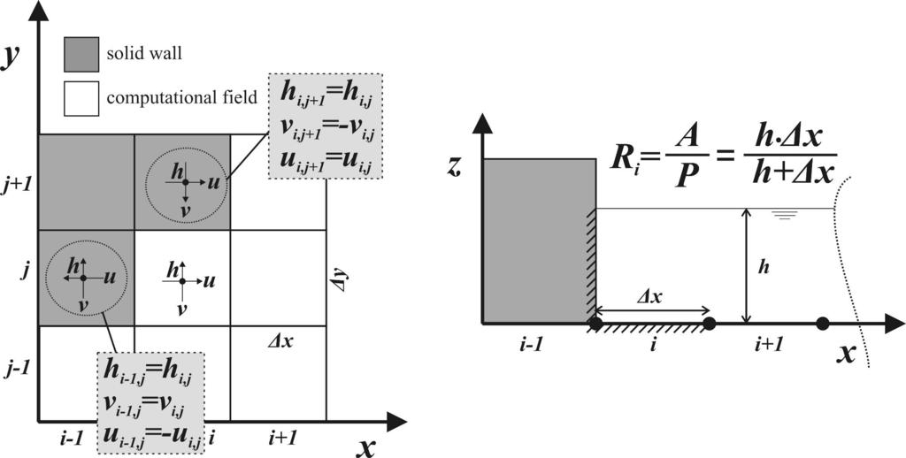
10 Solid boundaries


11 Comparison of the 3 methods Toce river physical model

12 Comparison of the 3 methods Toce river physical model
13 Upstream boundaries steady state flow elevation depth velocity
14 Upstream boundaries hydrograph
15 Upstream boundaries hydrograph Tous dam break
16 Downstream boundaries open kinematic wave
17 Source/sink terms Rainfall Infiltration Kostiakov equation Green-Ampt model Drainage Subway network


18 Catchment scale modelling Halandri catchment
19 Catchment scale modelling Halandri catchment
20 Calibration Computational burden Trial and error method Surrogate models Black-box or physically-based parameters? Friction coefficients Infiltration model parameters Building representation Grid size DTM Diffusion factor Effective slope (upstream boundaries) Courant number Wet/dry threshold

21 Surrogate models data driven Multistart Local Metric Stochastic Radial Basis Function Computational budget 100 runs Parameters calibrated: Manning coefficient n=0.194 s/m 1/3 Effective slope S eff =0.019 Better than trial and error method Sufficient space exploration Tous dam break
22 Surrogate models simplification Catchment scale modelling Hybrid method combining hydrodynamic and hydrological techniques Halandri catchment Unit Hydrograph derivation Effective rainfall determination Flood hydrograph simulation
23 Uncertainties Input data DTM Model structure 1D vs 2D FDM vs FEM Model parameters Friction coefficients Building representation parameters Grid size Monte-Carlo technique cannot be implemented Surrogate models Interval analysis

24 Uncertainty DTM Tous dam break
25 Uncertainty model structure Acheloos river 1D vs 2D
26 Uncertainty model structure Sperhios river FDM vs FEM
27 Uncertainty - friction Tous dam break Halandri catchment Scenario MSEMIN MSEAVG MSEMAX
28 Uncertainty building representation Toce river physical model elevation increase friction increase

29 Uncertainty grid size Experiment
30 Conclusion Decrease of computational burden for Decision Making Parallel programming Upscaling techniques Surrogate models Physically-based or black-box parameters?

31 Partners and Acknowledgements This project has received funding from the European Union s Seventh Framework Programme for research, technological development and demonstration under grant agreement no
TOPMODEL. Download Information Availability: Nonproprietary, (http://www.es.lancs.ac.uk/hfdg/topmodel.html) Cost: None for non-commercial uses.
 Cost: None for non-commercial uses.") TOPMODEL Contact Information Keith Beven Department of Environmental Science Institute of Environmental and Natural Sciences Lancaster University Lancaster LA1 4YQ United Kingdom +44 (0)1524 593892 K.Beven@lancaster.ac.uk
TOPMODEL Contact Information Keith Beven Department of Environmental Science Institute of Environmental and Natural Sciences Lancaster University Lancaster LA1 4YQ United Kingdom +44 (0)1524 593892 K.Beven@lancaster.ac.uk
Influence of river routing methods on integrated catchment water quality modelling
 European Water 57: 267-272, 2017. 2017 E.W. Publications Influence of river routing methods on integrated catchment water quality modelling A. Moreno-Rodenas 1*, V. Bellos 2,3, J. Langeveld 1 and F. Clemens
Learning objectives. Upon successful completion of this lecture, the participants will be able to describe:
 Solomon Seyoum Learning objectives Upon successful completion of this lecture, the participants will be able to describe: The different approaches for estimating peak runoff for urban drainage network
USE OF 2D MODELS TO CALCULATE FLOOD WATER LEVELS: CALIBRATION AND SENSITIVITY ANALYSIS
 USE OF 2D MODELS TO CALCULATE FLOOD WATER LEVELS: CALIBRATION AND SENSITIVITY ANALYSIS A. PAQUIER 1, E. MIGNOT 1 1 Cemagref, Hydrology Hydraulics Research Unit, 3 bis, quai Chauveau, CP220, 69336 Lyon
RAINFALL-RUNOFF STUDY FOR SINGAPORE RIVER CATCHMENT
 10 th International Conference on Hydroinformatics HIC 2012, Hamburg, GERMANY RAINFALL-RUNOFF STUDY FOR SINGAPORE RIVER CATCHMENT CHI DUNG DOAN (1)(3), JIANDONG LIU (1), SHIE-YUI LIONG (1), ADRI VERWEY
The Texas A&M University and U.S. Bureau of Reclamation Hydrologic Modeling Inventory (HMI) Questionnaire
 Questionnaire") The Texas A&M University and U.S. Bureau of Reclamation Hydrologic Modeling Inventory (HMI) Questionnaire May 4, 2010 Name of Model, Date, Version Number Dynamic Watershed Simulation Model (DWSM) 2002
The Texas A&M University and U.S. Bureau of Reclamation Hydrologic Modeling Inventory (HMI) Questionnaire May 4, 2010 Name of Model, Date, Version Number Dynamic Watershed Simulation Model (DWSM) 2002
Hydrologic Engineering Center Hydrologic Modeling System (HEC-HMS) Sunil KUMAR Director, National Water Academy
 Sunil KUMAR Director, National Water Academy") Hydrologic Engineering Center Hydrologic Modeling System (HEC-HMS) Sunil KUMAR Director, National Water Academy 22 April 2015 NWA, Pune Exercise Objective: To determine hydrological Response of the given
Hydrologic Engineering Center Hydrologic Modeling System (HEC-HMS) Sunil KUMAR Director, National Water Academy 22 April 2015 NWA, Pune Exercise Objective: To determine hydrological Response of the given
Hydraulic and Sediment Transport Modeling Strategy
 Appendix B Hydraulic and Sediment Transport May 2014 Technical Memorandum Channel Capacity Report September 2014 San Joaquin River Restoration Program Hydraulic and Sediment Transport The San Joaquin River
BMP Design Aids. w w w. t r a n s p o r t a t i o n. o h i o. g o v. Equations / Programs
 BMP Design Aids 1 Equations / Programs Outlet Discharge Equations Hydrograph and Pond Routing Programs USGS StreamStats 2 Ohio Department of Transportation 1 Training Intent Introduction and overview of
Address for Correspondence
 Research Paper DYNAMIC FLOOD ROUTING AND UNSTEADY FLOW MODELLING: A CASE STUDY OF UPPER KRISHNA RIVER 1 Doiphode Sanjay L* 2 Oak Ravindra A. Address for Correspondence 1 M tech Student, Bharati Vidyapeeth
Water Budget III: Stream Flow P = Q + ET + G + ΔS
 Water Budget III: Stream Flow P = Q + ET + G + ΔS Why Measure Streamflow? Water supply planning How much water can we take out (without harming ecosystems we want to protect) Flood protection How much
Water Budget III: Stream Flow P = Q + ET + G + ΔS
 Water Budget III: Stream Flow P = Q + ET + G + ΔS Why Measure Streamflow? Water supply planning How much water can we take out (without harming ecosystems we want to protect) Flood protection How much
Incorporating Ice Effects in Ice Jam Release Surge Models
 CGU HS Committee on River Ice Processes and the Environment 13th Workshop on the Hydraulics of Ice Covered Rivers Hanover, NH, September15-16, 25 Incorporating Ice Effects in Ice Jam Release Surge Models
Analysis and Simulation of Drainage Capacity of Urban Pipe Network
 Research Journal of Applied Sciences, Engineering and Technology 6(3): 387-392, 2013 ISSN: 2040-7459; e-issn: 2040-7467 Maxwell Scientific Organization, 2013 Submitted: July 17, 2012 Accepted: August 28,
River Processes River action (fluvial)
") River action (fluvial) is probably the single most important geomorphic agent and their influence in geomorphology can hardly be overestimated. 1 To understand the complexity associated with river flow
River action (fluvial) is probably the single most important geomorphic agent and their influence in geomorphology can hardly be overestimated. 1 To understand the complexity associated with river flow
MODULE 1 RUNOFF HYDROGRAPHS WORKSHEET 1. Precipitation
 Watershed MODULE 1 RUNOFF HYDROGRAPHS WORKSHEET 1 A watershed is an area of land thaaptures rainfall and other precipitation and funnels it to a lake or stream or wetland. The area within the watershed
Integrated Hydrology Model (InHM( HM): Development, Testing, and Applications
: Development, Testing, and Applications") Integrated Hydrology Model (InHM( HM): Development, Testing, and Applications DYNAS Workshop ``Numerical Modeling for Hillslope Hydrology'' INRIA Rocquencourt -- 6 to 8 December 24 Joel VanderKwaak 1,2
Integrated Hydrology Model (InHM( HM): Development, Testing, and Applications DYNAS Workshop ``Numerical Modeling for Hillslope Hydrology'' INRIA Rocquencourt -- 6 to 8 December 24 Joel VanderKwaak 1,2
HYDRO Portal: DHI s response to AR&R
 DHI UK & Ireland Symposium 27th June 2017 HYDRO Portal: DHI s response to AR&R What is Australian Rainfall & Runoff (AR&R) 2016 Revised design rainfall estimates based on gauge records (last updated in
ONE DIMENSIONAL DAM BREAK FLOOD ANALYSIS FOR KAMENG HYDRO ELECTRIC PROJECT, INDIA
 ONE DIMENSIONAL DAM BREAK FLOOD ANALYSIS FOR KAMENG HYDRO ELECTRIC PROJECT, INDIA S. Masood Husain Nitya Nand Rai Director Assistant Director Foundation Engineering & Special Analysis Directorate Central
Lecture 9A: Drainage Basins
 GEOG415 Lecture 9A: Drainage Basins 9-1 Drainage basin (watershed, catchment) -Drains surfacewater to a common outlet Drainage divide - how is it defined? Scale effects? - Represents a hydrologic cycle
10(a) Bridge and culvert design information
 Bridge and culvert design information") 10(a) Bridge and culvert design information The following information is required to accompany resource consent applications for bridges or culverts on waterways. Please answer all questions if possible.
10(a) Bridge and culvert design information The following information is required to accompany resource consent applications for bridges or culverts on waterways. Please answer all questions if possible.
Autumn semester of Prof. Kim, Joong Hoon
 1 Autumn semester of 2010 Prof. Kim, Joong Hoon Water Resources Hydrosystems System Engineering Laboratory Laboratory 2 A. HEC (Hydrologic Engineering Center) 1 Established in the U.S. Army Corps of Engineers(USACE)
Opanuku Stream Accuracy Benchmark 1. Introduction
 Opanuku Stream Accuracy Benchmark 1. Introduction 1.1 Fundamental Approach The proposed approach to flood model accuracy assessment uses data directly measured during an actual physical flood event. In
Index. Page numbers followed by f indicate figures.
 Index Aerodynamic method, 103, 110 111 Algae, 131, 173, 175 Alternate depth, 88 Alternating block method, 132, 140 141 Attenuation, 106, 107f, 118, 120 Page numbers followed by f indicate figures. Baseflow
Numerical Simulation of Flood Routing in Complex Hydraulic Schemes. The Routing System Computer Program
 Numerical Simulation of Flood Routing in Complex Hydraulic Schemes. The Routing System Computer Program JEROME DUBOIS JEAN-LOUIS BOILLAT Laboratory of Hydraulic Constructions, LCH, Swiss Federal Institute
Water Budget III: Stream Flow P = Q + ET + G + ΔS
 Water Budget III: Stream Flow P = Q + ET + G + ΔS Why Measure Streamflow? Water supply planning How much water can we take out (without harming ecosystems we want to protect) Flood protection How much
Level 6 Graduate Diploma in Engineering Hydraulics and hydrology
 910-103 Level 6 Graduate Diploma in Engineering Hydraulics and hydrology Sample Paper You should have the following for this examination one answer book ordinary graph paper pen, pencil, ruler Work sheet
Water Budget III: Stream Flow P = Q + ET + G + ΔS
 Water Budget III: Stream Flow P = Q + ET + G + ΔS Why Measure Streamflow? Water supply planning How much water can we take out (without harming ecosystems we want to protect) Flood protection How much
Recent development and application of a rapid flood spreading method
 Flood Risk Management: Research and Practice Samuels et al. (eds) 2009 Taylor & Francis Group, London, ISBN 978-0-415-48507-4 Recent development and application of a rapid flood spreading method Julien
Control and mitigation of floods along transbasin diversion channel of Mekong tributaries and Nan river, Thailand
 Control and mitigation of floods along transbasin diversion channel of Mekong tributaries and Nan river, Thailand Tawatchai Tingsanchali* School of Civil Engineering, Asian Institute of Technology, P.O.Box
Flood forecasting model based on geographical information system
 192 Remote Sensing and GIS for Hydrology and Water Resources (IAHS Publ. 368, 2015) (Proceedings RSHS14 and ICGRHWE14, Guangzhou, China, August 2014). Flood forecasting model based on geographical information
Odense & VCS Denmark 3rd largest city in Denmark 200,000 Inhabitants Birthplace of H.C. Andersen VCS Denmark est Reputation for innovation
 Integreret modellering i Odense. En ny tilgang til udvikling af langsigtede og integrerede spildevands- og regnvandsløsninger Dansk Vand Konference November 2016 Odense & VCS Denmark 3rd largest city in
Learning objectives. Upon successful completion of this lecture, the participants will be able to:
 Solomon Seyoum Learning objectives Upon successful completion of this lecture, the participants will be able to: Describe and perform the required step for designing sewer system networks Outline Design
Simulation of horizontal well performance using Visual MODFLOW
 Environ Earth Sci (2013) 68:1119 1126 DOI 10.1007/s12665-012-1813-x ORIGINAL ARTICLE Simulation of horizontal well performance using Visual MODFLOW Wan Mohd Zamri W. Ismail Ismail Yusoff Bahaa-eldin E.
Flood forecasting model based on geographical information system
 doi:10.5194/piahs-368-192-2015 192 Remote Sensing and GIS for Hydrology and Water Resources (IAHS Publ. 368, 2015) (Proceedings RSHS14 and ICGRHWE14, Guangzhou, China, August 2014). Flood forecasting model
APPENDIX F RATIONAL METHOD
 7-F-1 APPENDIX F RATIONAL METHOD 1.0 Introduction One of the most commonly used procedures for calculating peak flows from small drainages less than 200 acres is the Rational Method. This method is most
COMPUTER APPLICATIONS HYDRAULIC ENGINEERING
 - 7535 COMPUTER APPLICATIONS IN HYDRAULIC ENGINEERING Connecting Theory to Practice Fifth Edition HAESTAD PRESS Table of Contents Revision History Foreword CHAPTER 1 BASIC HYDRAULIC PRINCIPLES 1 1.1 General
Hydrologic engineering Hydraulic engineering Environmental engineering Ecosystems engineering Water resources engineering
 Water Engineering Water Systems: Drainage, flood control, storage (dams), water supply, hydropower, diversion, river training, etc. Planning, design, operation and management of water systems; policy making;
Hydrologic Modeling Overview
 Hydrologic Modeling Overview Chuck Downer, PhD, PE Hydrologic Systems Branch Coastal and Hydraulics Laboratory Engineer Research and Development Center Vicksburg, Mississippi Hydrologic processes Hydrologic
SPATIAL-TEMPORAL ADJUSTMENTS OF TIME OF CONCENTRATION
 JOURNAL O LOOD ENGINEERING J E 1(1) January June 2009; pp. 21 28 SPATIAL-TEMPORAL ADJUSTMENTS OF TIME OF CONCENTRATION Kristin L. Gilroy & Richard H. McCuen Dept. of Civil and Environmental Engineering,
Pluvial flooding and efficiency of urban drainage
 The 9 th International Conference on Urban Drainage Modelling Belgrade, 3-7 September 2012 Pluvial flooding and efficiency of urban drainage Anna Palla 1, Francesca Franza 2, Ilaria Gnecco 1, Giuseppe
Ballard Phase I/Retrofit Supplemental Monitoring Plan
 MEMORANDUM Ballard Phase I/Retrofit Supplemental Monitoring Plan PREPARED FOR: Seattle Public Utilities PREPARED BY: CH2M HILL DATE: August 17, 2012 Introduction This memo summarizes the plans for and
Introduction. Keywords: Oil Palm, hydrology, HEC-HMS, HEC-RAS. a * b*
 The Effect of Land Changes Towards in Sg. Pandan Perwira Bin Khusairi Rahman 1,a* and Kamarul Azlan bin Mohd Nasir 1,b 1 Faculty of Civil Engineering, Universiti Teknologi Malaysia, Malaysia a * wirakhusairirahman@gmail.com,
Floodplain mapping via 1D and quasi-2d numerical models in the valley of Thessaly, Greece
 European Geosciences Union General Assembly 2013 Vienna, Austria, 07-12 April 2013 Session HS6.4: Hydrology and remote sensing: current platforms and the future SWOT mission, Vol. 15, EGU2013-10366 Floodplain
Chapter 7 : Conclusions and recommendations
 Chapter 7 : Conclusions and recommendations 7.1 Conclusions The main goal of this research was to investigate the modelling and rainfall data requirements for the design of combined sewer systems and the
1CE037P3 INTERREG IVB Project Central Europe LABEL
 1CE037P3 INTERREG IVB Project Central Europe LABEL Project activity 3.3.4 LUŽNICE NOVÁ ŘEKA NEŽÁRKA WATER MANAGEMENT JUNCTION ASSESSMENT OF THE EFFECTS OF DESIGNED AND POSSIBLE RETENTION MEASURES ON HYDRAULIC
Introduction to Land Surface Modeling Hydrology. Mark Decker
 Introduction to Land Surface Modeling Hydrology Mark Decker (m.decker@unsw.edu.au) 1) Definitions 2) LSMs 3) Soil Moisture 4) Horizontal Fluxes 5) Groundwater 6) Routing Outline 1) Overview & definitions
4.2 Discharge measurement by Velocity Area Method (Chitale, 1974)
") 4.2 Discharge measurement by Velocity Area Method (Chitale, 1974) This method comprises measuring the mean velocity V and the flow area 'A' and computing the discharge Q from the continuity equation. The
4.2 Discharge measurement by Velocity Area Method (Chitale, 1974) This method comprises measuring the mean velocity V and the flow area 'A' and computing the discharge Q from the continuity equation. The
URBAN FLOODING: HEC-HMS
 1.0 Introduction URBAN FLOODING: HEC-HMS -Sunil Kumar, Director, NWA All major ancient civilisations were developed in the river valleys because river served as source of water, food, transportation and
Uncertainty based decision making for water quality failures caused by sewer overflows
 Uncertainty based decision making for water quality failures caused by sewer overflows Ambuj Sriwastava, University of Sheffield J.A. Torres-Matallana, Luxembourg Institute of Sceince & Technology Simon
CIE4491 Lecture. Quantifying stormwater flow Rational method
 CIE4491 Lecture. Quantifying stormwater flow Rational method 27-5-2014 Marie-claire ten Veldhuis, Watermanagement Department Delft University of Technology Challenge the future Robust method stationary
Reservoir on the Rio Boba
 Reservoir on the Rio Boba Michael J. Burns II Guillermo Bustamante J. James Peterson Executive Summary The National Institute of Water Resources in the Dominican Republic (INDRHI) plans to construct a
Analysis of a Partial Blowout in the Leadville Mine Drainage Tunnel, Leadville, CO. Brianna Svoboda Colorado School of Mines 4/24/14
 Analysis of a Partial Blowout in the Leadville Mine Drainage Tunnel, Leadville, CO Brianna Svoboda Colorado School of Mines 4/24/14 1.0 Introduction The United States Bureau of Reclamation requested a
NUMERICAL MODELLING OF THE GROUNDWATER FLOW IN THE LEFT FLOODPLAIN AREA OF THE DANUBE RIVER
 Proceedings of ALGORITMY 2002 Conference on Scientific Computing, pp. 237 244 NUMERICAL MODELLING OF THE GROUNDWATER FLOW IN THE LEFT FLOODPLAIN AREA OF THE DANUBE RIVER A. BALÁŽOVÁ, D. BAROKOVÁ, K. MIKULA,
MULTI-LAYER MESH APPROXIMATION OF INTEGRATED HYDROLOGICAL MODELING FOR WATERSHEDS: THE CASE OF THE YASU RIVER BASIN
 MULTI-LAYER MESH APPROXIMATION OF INTEGRATED HYDROLOGICAL MODELING FOR WATERSHEDS: THE CASE OF THE YASU RIVER BASIN Toshiharu KOJIRI and Amin NAWAHDA 1 ABSTRACT A method for applying the multi-layer mesh
DAM BREAK ANALYSIS & DISASTER MANAGEMENT PLAN
 11 DAM BREAK ANALYSIS & DISASTER MANAGEMENT PLAN 11.1 INTRODUCTION 11.1.1 Dam Break Phenomenon The construction of dams in rivers can provide considerable benefits such as the supply of drinking and irrigation
Smart flood forecasting infrastructure with uncertainties. Georges Kesserwani University of Sheffield
 Smart flood forecasting infrastructure with uncertainties Georges Kesserwani University of Sheffield 25 January 29/01/2018 2018 TSUNAMI-CODE - Advancing our ability to forecast Urban multi-scale Flood
Comparison of 1D-1D and 1D-2D urban flood models
 15 th International Conference on Environmental Science and Technology Rhodes, Greece, 31 August to 2 September 217 Comparison of and urban flood models Kourtis I. M. 1, *, Bellos V. 1, Tsihrintzis V.
K.Sangeetha, B.Narasimhan Department of Civil Engineering, Indian Institute of Technology, Madras
 Analytic Element Method (AEM) and its Relevance with Subbasin/HRU concept of SWAT for potential integration of AEM based simple ground water model K.Sangeetha, B.Narasimhan Department of Civil Engineering,
FLOOD INUNDATION ANALYSIS FOR METRO COLOMBO AREA SRI LANKA
 FLOOD INUNDATION ANALYSIS FOR METRO COLOMBO AREA SRI LANKA Mohamed Mashood Mohamed Moufar* (MEE 13633) Supervisor: Dr. Duminda Perera**, ABSTRACT The canal network in Metro Colombo area in Sri Lanka, initially
TULLAMORE FLOOD RISK ASSESSMENT AND MANAGEMENT STUDY
 TULLAMORE FLOOD RISK ASSESSMENT AND MANAGEMENT STUDY FINAL HYDRAULICS REPORT 1794/RP/004/C June 2008 FRAM Section Engineering Services Office of Public Works Doc. No. 1794/RP/004/C ii June 2008 INDEX OF
Scale Effects in Large Scale Watershed Modeling
 Scale Effects in Large Scale Watershed Modeling Mustafa M. Aral and Orhan Gunduz Multimedia Environmental Simulations Laboratory School of Civil and Environmental Engineering Georgia Institute of Technology
RIVER DISCHARGE PROJECTION IN INDOCHINA PENINSULA UNDER A CHANGING CLIMATE USING THE MRI-AGCM3.2S DATASET
 RIVER DISCHARGE PROJECTION IN INDOCHINA PENINSULA UNDER A CHANGING CLIMATE USING THE MRI-AGCM3.2S DATASET Duc Toan DUONG 1, Yasuto TACHIKAWA 2, Michiharu SHIIBA 3, Kazuaki YOROZU 4 1 Student Member of
SECTION IV WATERSHED TECHNICAL ANALYSIS
 A. Watershed Modeling SECTION IV WATERSHED TECHNICAL ANALYSIS An initial step in the preparation of this stormwater management plan was the selection of a stormwater simulation model to be utilized. It
2
 1 2 3 4 5 6 The program is designed for surface water hydrology simulation. It includes components for representing precipitation, evaporation, and snowmelt; the atmospheric conditions over a watershed.
Overview of NRCS (SCS) TR-20 By Dr. R.M. Ragan
 TR-20 By Dr. R.M. Ragan") Overview of NRCS (SCS) TR-20 By Dr. R.M. Ragan TR-20 is a computer program for the simulation of runoff occurring from a single storm event. The program develops flood hydrographs from runoff and routes
Overview of NRCS (SCS) TR-20 By Dr. R.M. Ragan TR-20 is a computer program for the simulation of runoff occurring from a single storm event. The program develops flood hydrographs from runoff and routes
Physical processes and hydrodynamic modeling in lakes and reservoirs
 Physical processes and hydrodynamic modeling in lakes and reservoirs Thesis: Comparison of the 3D hydrodynamic models and predicting the response of reservoirs to climate change effects Behnam Zamani *
Modelling landscape opportunities, multiple benefits and impacts
 In partnership with: Modelling landscape opportunities, multiple benefits and impacts Iain Craigen and Charlotte Beattie Natural Flood Management and Working With Natural Processes There is a growing evidence
Faculty of Applied Science and Engineering. Department of Civil Engineering. Hydrology and Hydraulics. Final Exam, April 21, 2017
 F Name: Student #: University of Toronto Faculty of Applied Science and Engineering Department of Civil Engineering C1V250 - Hydrology and Hydraulics Final Exam, April 21, 2017 Duration: 2 and V2 hrs The
Evaluation of Risks Related to Ground Water Regime Changes
 The 3 rd International Conference on Water Resources and Arid Environments (2008) and the 1 st Arab Water Forum Evaluation of Risks Related to Ground Water Regime Changes David Duchan, Ales Drab, Ahmed
Groundwater Modeling Guidance
 Groundwater Modeling Guidance Richard J. Mandle Groundwater Modeling Program Michigan Department of Environmental Quality Draft 1.0 10/16/02 Executive Summary The use of groundwater models is prevalent
Dynamic groundwater-river interaction model for planning water allocation in a narrow valley aquifer system of the Upper Motueka catchment
 Dynamic groundwater-river interaction model for planning water allocation in a narrow valley aquifer system of the Upper Motueka catchment Timothy Hong t.hong@gns.cri.nz Gilles Minni g.minni@gns.cri.nz
SOUTHEAST TEXAS CONTINUING EDUCATION
 EXAM No. 118 FLOOD - RUNOFF ANALYSIS 1. Information gained from flood - runoff analysis includes which one: A. Stage, discharge, volume. B. Measure depth, volume. C. Velocity, depth, storm occurrence.
CHAPTER 2. Objectives of Groundwater Modelling
 CHAPTER 2 Objectives of Groundwater Modelling In the last two decades mathematical modelling techniques have increasingly proved their value in furthering the understanding of groundwater systems and,
HYDRODYNAMIC SIMULATION OF SURFACE WATER CONTROL SLUICE GATES BY HEC-RAS MODEL
 nd International Conference - Water resources and wetlands. - September, 04 Tulcea (Romania); Available online at http://www.limnology.ro/water04/proceedings.html Editors: Petre Gâştescu ; Włodzimierz
Climate Simulation Irrigation Winter Processes Surface Hydrology Water Balance & Percolation Subsurface Hydrology Soil Component Plant Growth Residue
 Climate Simulation Irrigation Winter Processes Surface Hydrology Water Balance & Percolation Subsurface Hydrology Soil Component Plant Growth Residue Decomposition and Management Overland Flow Hydraulics
Questions: What is calibration? Why do we have to calibrate a groundwater model? How would you calibrate your groundwater model?
 Questions: What is calibration? Why do we have to calibrate a groundwater model? How would you calibrate your groundwater model? 13-11-2009 1 Uncertainties in groundwater models Conceptual model uncertainty
Upstream structural management measures for an urban area flooding in Turkey
 doi:10.5194/piahs-370-45-2015 Author(s) 2015. CC Attribution 3.0 License. Upstream structural management measures for an urban area flooding in Turkey Z. Akyurek 1, B. Bozoğlu 1, S. Sürer 2, and H. Mumcu
Using SWMM 5 in the continuous modelling of stormwater hydraulics and quality
 Using SWMM 5 in the continuous modelling of stormwater hydraulics and quality M.J. Cambez 1, J. Pinho 1, L.M. David 2 * 1 Trainee at Laboratório Nacional de Engenharia Civil (LNEC) 2 Research Officer at
Lateral Outflow from Supercritical Channels
 Lateral Outflow from Supercritical Channels J. Coonrod 1, J. Ho 2 and N. Bernardo 3 1 Associate Professor, Department of Civil Engineering, University of New Mexico, Albuquerque, NM 87131; PH (505) 277-3233;
Hydrogeology of the Merti Aquifer. Impact of abstractions on drawdown of water level and salinity. Arjen Oord Jan de Leeuw (presenter)
") Hydrogeology of the Merti Aquifer Impact of abstractions on drawdown of water level and salinity Arjen Oord Jan de Leeuw (presenter) Impacts of abstractions? Abstractions have two major geo-hydrological
Hydrogeology of the Merti Aquifer Impact of abstractions on drawdown of water level and salinity Arjen Oord Jan de Leeuw (presenter) Impacts of abstractions? Abstractions have two major geo-hydrological
GreenPlan Modeling Tool User Guidance
 GreenPlan Modeling Tool User Guidance Prepared by SAN FRANCISCO ESTUARY INSTITUTE 4911 Central Avenue, Richmond, CA 94804 Phone: 510-746-7334 (SFEI) Fax: 510-746-7300 www.sfei.org Table of Contents 1.
Calibration and Testing of a Hydrodynamic Model of the Gippsland Lakes
 r Calibration and Testing of a Hydrodynamic Model of the Gippsland Lakes M.J. McMaster a,b, D.G. Provis b, R.B. Grayson a and W.A. Bishop b a Centre for Environmental Applied Hydrology, Department of Civil
Two-Dimensional Modelling of Flood Hazards in Urban Areas
 Two-Dimensional Modelling of Flood Hazards in Urban Areas Case Studies: Reservoirs, Watersheds Cornel Beffa Parallel Session (parallel15), 31.08.1998, 16:00-18:15 Simulation for Urban, Watershed and River
COMPOUND CHANNEL MODELLING CAPABILITY ASSESSMENT OF 1D HYDRAULIC MODEL
 COMPOUND CHANNEL MODELLING CAPABILITY ASSESSMENT OF 1D HYDRAULIC MODEL Jahangir Islam and Nick Brown Auckland Council ABSTRACT (200 WORDS MAXIMUM) Accurate modelling of streams or open channels in urban
Flood Analysis of Wainganga River by using HEC-RAS model
 Flood Analysis of Wainganga River by using HEC-RAS model Heena Ingale, R. V. Shetkar Government College of Engineering Aurangabad (M.S.) India Corresponding Email : heenaingale.gcoea@gmail.com Abstract:
RUNNING WATER AND GROUNDWATER
 NAME RUNNING WATER AND GROUNDWATER I. Introduction In this exercise we will investigate various features associated with streams and groundwater. Our drinking water ultimately comes from either streams
Criteria for the choice of flood routing methods for natural channels with overbank flow
 Criteria for the choice of flood routing methods for natural channels with overbank flow by Roger MOUSSA Laboratoire d'étude des Interactions Sol - Agrosystème - Hydrosystème UMR LISAH ENSA-INRA-IRD, Montpellier
Flood hazard assessment in the Raval District of Barcelona using a 1D/2D coupled model
 9 th International Conference on Urban Drainage Modelling Belgrade 2012 Flood hazard assessment in the Raval District of Barcelona using a 1D/2D coupled model Beniamino Russo, David Suñer, Marc Velasco,
APPLICATION OF A HYDRODYNAMIC MIKE 11 MODEL FOR THE EUPHRATES RIVER IN IRAQ
 2008/2 PAGES 1 7 RECEIVED 13.1.2008 ACCEPTED 26.4.2008 A. H. KAMEL APPLICATION OF A HYDRODYNAMIC MIKE 11 MODEL FOR THE EUPHRATES RIVER IN IRAQ Ing. Ammar H. Kamel Slovak University of Technology Faculty
Hydrologic Modeling System (HEC-HMS) Adaptions for Ontario
 Adaptions for Ontario") Hydrologic Modeling System (HEC-HMS) Adaptions for Ontario Bill Scharffenberg, PhD HEC-HMS Lead Developer 6 March 2018 Floodplain Mapping Knowledge Transfer Workshop Vaughan, Ontario How We View Our Role
Hydrologic Modeling System (HEC-HMS) Adaptions for Ontario Bill Scharffenberg, PhD HEC-HMS Lead Developer 6 March 2018 Floodplain Mapping Knowledge Transfer Workshop Vaughan, Ontario How We View Our Role
Biscayne National Park
 National Park Service U.S. Department of the Interior AN IMPROVED BISCAYNE BAY HYDRODYNAMIC MODEL FOR EVALUATION OF RESTORATION EFFORTS AND GROUNDWATER FLOW ON SALINITY Erik Stabenau & Amy Renshaw National
Physical models application of flow analysis in regulated reservoir dams
 River Basin Management III 15 Physical models application of flow analysis in regulated reservoir dams M. R. M. Tabatabai 1, S. Faghihirad 2 & M. Kolahdoozan 3 1 Water Engineering Department, Power and
Maintaining Ecohydrological Sustainability of Alberta s Urban Natural Areas Adjacent to Proposed Residential Developments
 Maintaining Ecohydrological Sustainability of Alberta s Urban Natural Areas Adjacent to Proposed Residential Developments Water Tech 2017, Banff, AB Urban Analysis, City Planning April 2017 Presented by
Failure Consequence Classification
 Failure Consequence Classification Audience: Dam Safety Officers (DSO) Owners of small dams Community emergency preparedness coordinators Introduction This document provides an overview of failure consequence
Event and Continuous Hydrological Modeling with HEC- HMS: A Review Study
 Event and Continuous Hydrological Modeling with HEC- HMS: A Review Study Sonu Duhan *, Mohit Kumar # * M.E (Water Resources Engineering) Civil Engineering Student, PEC University Of Technology, Chandigarh,
FORT COLLINS STORMWATER CRITERIA MANUAL Hydrology Standards (Ch. 5) 1.0 Overview
 1.0 Overview") Chapter 5: Hydrology Standards Contents 1.0 Overview... 1 1.1 Storm Runoff Determination... 1 1.2 Design Storm Frequencies... 1 1.3 Water Quality Storm Provisions... 2 1.4 Design Storm Return Periods...
Chapter 5: Hydrology Standards Contents 1.0 Overview... 1 1.1 Storm Runoff Determination... 1 1.2 Design Storm Frequencies... 1 1.3 Water Quality Storm Provisions... 2 1.4 Design Storm Return Periods...
Urban Flood Modelling Dissemination Seminar. 25 th Jan University of Sheffield James Shucksmith
 Urban Flood Modelling Dissemination Seminar 25 th Jan University of Sheffield James Shucksmith Aims of the Event Present and discuss ongoing research in the area of urban flood modelling, including 1.