USING ARCSWAT TO EVALUATE EFFECTS OF LAND USE CHANGE ON WATER QUALITY. Adam Gold Geog 591
|
|
|
- Brittney Turner
- 6 years ago
- Views:
Transcription

1 USING ARCSWAT TO EVALUATE EFFECTS OF LAND USE CHANGE ON WATER QUALITY Adam Gold Geog 591

 The USDA and Texas A&M University jointly developed SWAT, and Texas A&M has developed a")


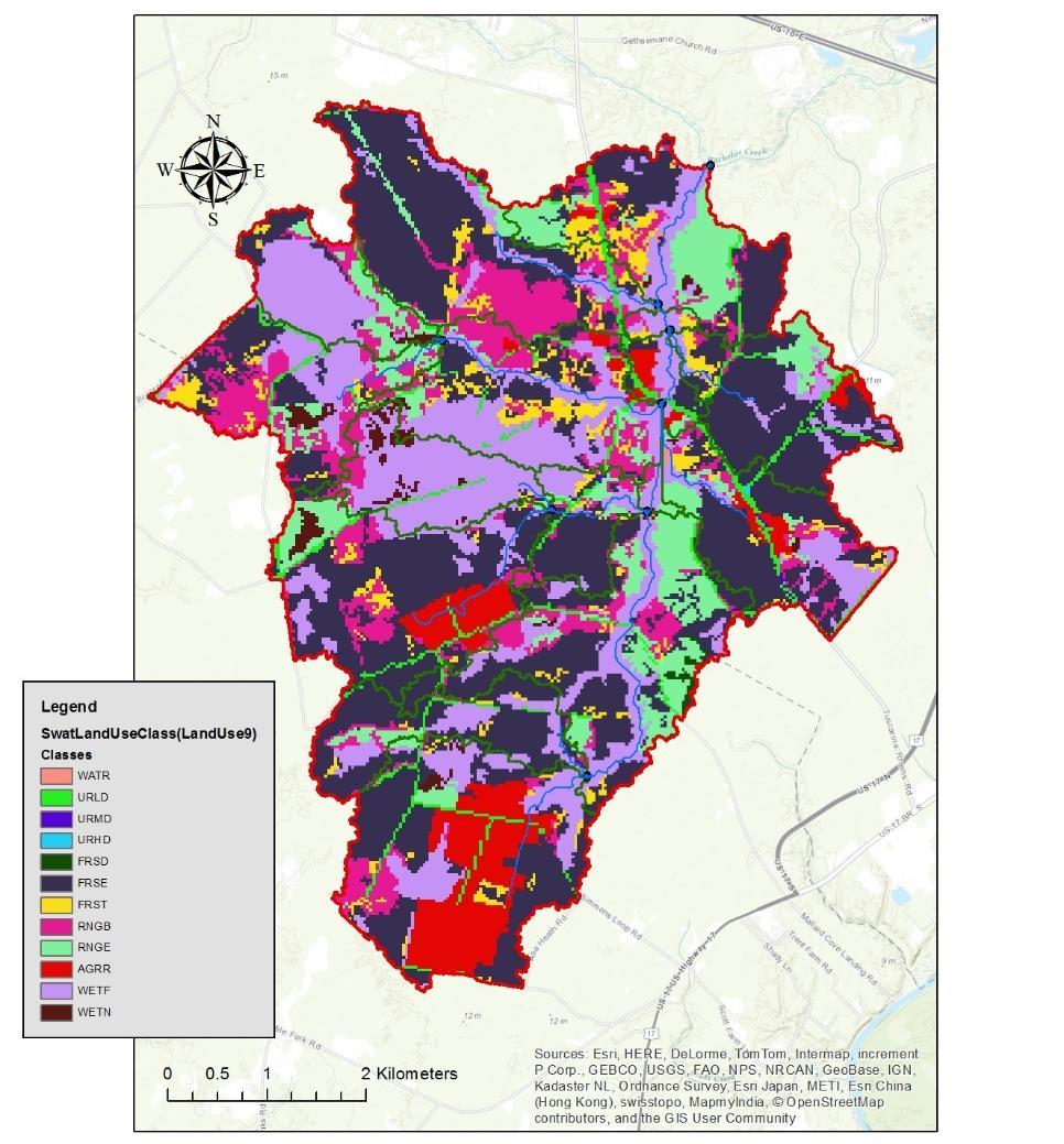
2 Introduction The Soil and Water Assessment Tool (SWAT) is a hydrologic transport model with an objective to predict the effect of management decisions on water, sediment, nutrient, and pesticide yields with reasonable accuracy on large, ungauged river basins. ( The USDA and Texas A&M University jointly developed SWAT, and Texas A&M has developed a graphical and visual interface of SWAT, ArcSWAT, for use with ArcGIS. ArcSWAT significantly improves the ease at which a user can create a SWAT model. ArcSWAT is available for free from My study site was a km 2 catchment located Northwest of Havelock, NC. I chose this area because of the organic rich soils, low slopes, and high incidence of land use change. µ µ Kilometers Source: Esri, DigitalGlobe, GeoEye, i-cubed, Earthstar Geographics, CNES/Airbus DS, USDA, USGS, AEX, Getmapping, Aerogrid, IGN, IGP, swisstopo, and the GIS User Community, Esri, HERE, DeLorme, TomTom, MapmyIndia, OpenStreetMap contributors, and the GIS user community Kilometers 2 Source: Esri, DigitalGlobe, GeoEye, i-cubed, Earthstar Geographics, CNES/Airbus DS, USDA, USGS, AEX, Getmapping, Aerogrid, IGN, IGP, swisstopo, and the GIS User Community, Esri, HERE, DeLorme, TomTom, MapmyIndia, OpenStreetMap contributors, and the GIS user community
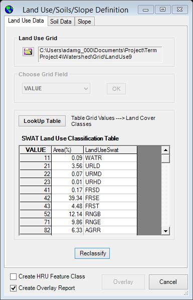
3 Objectives To use publicly available data to create an ArcSWAT model To use an ArcSWAT model to determine effects of land use change on modeled nutrient exports Methods Data Collection I used publicly available data to create my ArcSWAT model: Land Use Data: 2001, 2006, 2011 NLCD Data Elevation Data: 20 ft. lidar elevation Data for NC Soil Data: Soil Map Units Vector Layer ESRI ArcGIS Landscape1 Server, landscape1.arcgis.com_443 Weather Data: Temperature, Precipitation, Humidity, Solar Radiation, Wind Configuring and Running the Model 1. I imported all of my data into ArcGIS and converted all of the files to the same spatial reference and projection, NAD 1983 (2011) State Plane North Carolina FIPS 3200 (US Feet) 2. I created a new ArcSWAT project and saved it to my hard drive 3


4 4 3. I put my source DEM on the map and used the automatic watershed delineator to delineate the watersheds and perform various functions, such as flow direction, flow accumulation, and stream delineation
 through the soils map.")
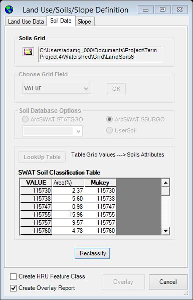
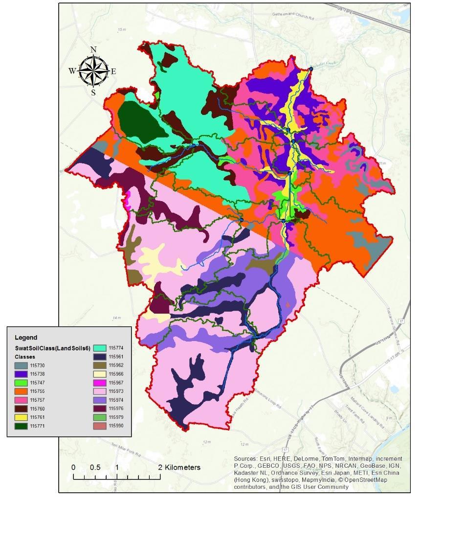
5 4. I added my land use and soils data to the map. I then used ArcSWAT to delineate HRU s based on the major soil and land use type in each sub-watershed. The study catchment lies in two counties, which are different soil survey districts. This is the reason for the straight line (from NW to SE) through the soils map. (The soils separated by the line are the same soil type, but were reported with slightly different keys.) 5
6 6


 based")
7 Soil 5. I then used ArcSWAT to define the catchment s Hydrologic Response Units (HRU s) based on the land use, soils, and slopes 7

 I had gathered")

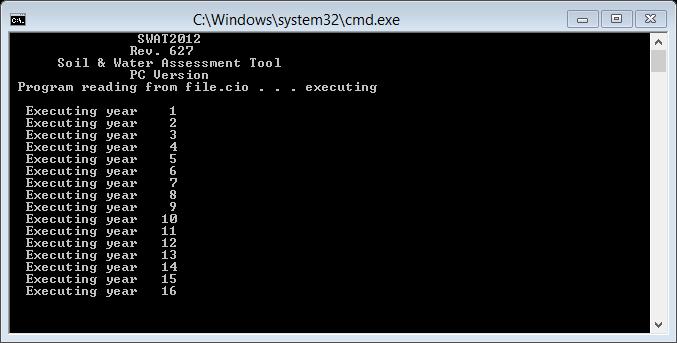
8 6. Next, I input the weather data (Temperature, Precipitation, Wind, Solar Radiation, and Relative Humidity) I had gathered 7. Finally, I wrote the input tables, set up SWAT, and ran the simulation 8
9 9


10 My Model I configured three different versions of my model. Each model was identical except for the Land Use Data. The first model used NLCD 2001 Data, the second model used NLCD 2006 Data, and the third model used NLCD 2011 Data. Each model predicted monthly values of various parameters for 21 years. 10
11 After running the models, I analyzed the output files for average annual Nitrate (NO 3) and Phosphorus (P) leached as well as average annual sediment transport downstream, surface runoff, and evapotranspiration. Results Table 1. Predicted Parameters from ArcSWAT Year N03 (kg/ha) P (kg/ha) Sediment (T/ha) Shrub/Scrub (% of Catchment) Surface Runoff Q (mm) ET (mm) *All values are average annual values Table 2. Land Use Change from 2001 to 2011 in the study catchment Change, Change, % of area Open Water Developed, Open Space 0.01 Developed, Low Intensity 0.02 Developed, Medium Intensity 0.01 Barren Land 0.06 Deciduous Forest Evergreen Forest Mixed Forest Shrub/Scrub Herbaceous Cultivated Crops Woody Wetlands Emergent Herbaceous Wetlands
12 ANNUAL SURFACE RUNOFF Q (MM) ANNUAL ET (MM) ANNUAL NUTRIENT LEACHED (KG/HA) ArcSWAT Model Results NO3 P Sediment (T/ha) R² = R² = R² = % CATCHMENT AREA SHRUB/SCRUB Figure 1. Predicted parameters from three ArcSWAT simulations of differing land use cover ArcSWAT Model Results Surface Runoff Q ET R² = R² = % CATCHMENT AREA SCHRUB/SCRUB Figure 2. Predicted parameters from three ArcSWAT simulations of differing land use cover Discussion Three ArcSWAT models were setup and run to predict monthly parameters for 21 years to increase the amount of iterations and decrease variability in predictions. 252 sets of 12
13 predictions went in to calculating each parameters average annual value, which makes the trends in Figure 1 and Figure 2 more meaningful. Of the studied parameters, amount of Nitrate leached was found to be the most correlated to the percent of catchment area Shrub/Scrub (R 2 =.875). Average annual Nitrate leached, Phosphorus leached, sediment loading, and surface runoff all increased with increasing percentage of catchment area Shrub/Scrub. Amount of Phosphate leached did not change significantly as the percentage of catchment area Shrub/Scrub increased, and Evapotranspiration decreased as Shrub/Scrub became more prevalent. Conclusion ArcSWAT is a powerful tool that makes SWAT much easier to setup and run correctly. A calibrated ArcSWAT model can be extremely useful for predicting water quality and hydrologic dynamics in gauged and ungauged catchments. Changing the land use of a catchment greatly impacts many of the biotic and abiotic processes affecting water quality and hydrologic dynamics, and my investigation demonstrates this fact. Future work on this project that I hope to complete is to calibrate this model or a similar model with data (stream discharge, nitrate levels, turbidity) that I collect from the site. It is important to note that my model was not calibrated, so the results from this investigation should not be used to actively predict parameters for this catchment. Actively using this model would require careful calibration and measurements directly from my study catchment. Rather, this investigation should be used to illustrate the viability of ArcSWAT and other models to be used experimentally. 13
14 Works Cited SWAT Information: ArcSWAT Software: Land Use Data: Soils Data: ESRI Landscape1 Server, landscape1.arcgis.com_443 Elevation Data: Weather Data: 14
SimWater: Simulating Water Supply, Demand, and Management Mountains to Valley: Balancing forests, rivers, and downstream water users
 Name: Date: SimWater: Simulating Water Supply, Demand, and Management Mountains to Valley: Balancing forests, rivers, and downstream water users Water managers are entrusted to best allocate water based
J.H. CAMPBELL GENERATING FACILITY BOTTOM ASH POND 3 HAZARD POTENTIAL CLASSIFICATION ASSESSMENT REPORT. Assessment Report. Pursuant to 40 CFR 257.
 Hazard Potential Classification Assessment Report J.H. CAMPBELL GENERATING FACILITY BOTTOM ASH POND 3 HAZARD POTENTIAL CLASSIFICATION ASSESSMENT REPORT West Olive, Michigan Pursuant to 40 CFR 257.73 Submitted
FIGURE 1 KUSKOKWIM RIVER MITIGATION BANK LOCATION MAP for BANK SITES LEVEL III ECOREGIONS, & 8-DIGIT HUCs
 19040803 Lower Innoko River Donlin Mine Alaska Project Location Interior Forested Lowlands and Uplands Source: Esri, DigitalGlobe, GeoEye, icubed, Earthstar Geographics, CNES/Airbus 19030501 Aniak Fuller
J.H. CAMPBELL GENERATING FACILITY BOTTOM ASH PONDS 1-2 HAZARD POTENTIAL CLASSIFICATION ASSESSMENT REPORT. Assessment Report. Pursuant to 40 CFR 257.
 Hazard Potential Classification Assessment Report J.H. CAMPBELL GENERATING FACILITY BOTTOM ASH PONDS 1-2 HAZARD POTENTIAL CLASSIFICATION ASSESSMENT REPORT West Olive, Michigan Pursuant to 40 CFR 257.73
Study of Hydrology based on Climate Changes Simulation Using SWAT Model At Jatiluhur Reservoir Catchment Area
 Study of Hydrology based on Climate Changes Simulation Using SWAT Model At Jatiluhur Reservoir Catchment Area Budi Darmawan Supatmanto 1, Sri Malahayati Yusuf 2, Florentinus Heru Widodo 1, Tri Handoko
WATER QUALITY MONITORING PLAN PROPOSED SPRINGS EQUESTRIAN CENTER RESCUE, CALIFORNIA (APN )
") WATER QUALITY MONITORING PLAN PROPOSED SPRINGS EQUESTRIAN CENTER RESCUE, CALIFORNIA (APN 115-410-05-100) BSK PROJECT E1506501S PREPARED FOR: ESSENTIAL PROPERTIES GROUP, INC. 970 RESERVE DRIVE, BUILDING
WATER QUALITY MONITORING PLAN PROPOSED SPRINGS EQUESTRIAN CENTER RESCUE, CALIFORNIA (APN 115-410-05-100) BSK PROJECT E1506501S PREPARED FOR: ESSENTIAL PROPERTIES GROUP, INC. 970 RESERVE DRIVE, BUILDING
Illinois Route 47/I-88 Interchange Improvements
 Looking north at Illinois 47 south of the I-88. Illinois Route 47/I-88 Interchange Improvements Tree Survey Kane County, Illinois Prepared by Quigg Engineering Inc. (QEI) October 2, 2015 Table of Contents
Runoff Water Management in Bailadila Range, Kirandul, India
 GIS in Water Resources Final Project Report Runoff Water Management in Bailadila Range, Kirandul, India Anamika Kumari Under Guidance of Dr. David R. Maidment December 1, 215 Contents 1. Introduction 1
SWAT modeling of Arroyo Colorado watershed
 SWAT modeling of Arroyo Colorado watershed Narayanan Kannan Texas AgriLife Research (Texas A&M University System) Temple Need for the project Arroyo Colorado failed to meet Texas water quality standards
Exceptional Equipment Storage and Office/Warehouse Site 8.0 +/- Acres
 50th Street Document Name: Orient Road 8 ac Very Wide 8x11 Tampa Bay Trucking Center Inc. UV600 Pepin Distributing 92 Netparks Tampa Bay Hillsborough Avenue UV 400 UV 4 583 Interstate Corporate Center
JOINT PUBLIC NOTICE April 27, 2015
 JOINT PUBLIC NOTICE April 27, 2015 United States Army State of Louisiana Corps of Engineers Department of Environmental Quality New Orleans District Post Office Box 4313 Regulatory Branch Baton Rouge,
ADDITIONAL TABLES AND INFORMATION
 APPENDIX D: ADDITIONAL TABLES AND INFORMATION NE JACKSON SCHOOL ROAD (NE GRANT ST. - NW EVERGREEN RD.) PROJECT WASHINGTON COUNTY, OREGON Tax Lots Traversed by the Project Study Area 1N230AB00600 1N230BA04000
Watershed Modeling of Haw River Basin using SWAT for Hydrology, Water Quality and Climate Change Study
 Watershed Modeling of Haw River Basin using SWAT for Hydrology, Water Quality and Climate Change Study Somsubhra Chattopadhyay, Graduate Student Manoj K. Jha, Assistant Professor Civil Engineering Department
3901 Industrial Boulevard Indianapolis, IN 46240
 Joint Public Notice Public Notice No. Open Date: Close Date: LRL-2015-844-sam 6 Jul 2016 8 Aug 2016 US Army Corps of Engineers Louisville District Please address all comments and inquiries to: U.S. Army
Information for File # KAL
 Information for File # 2016-03711-KAL Applicant Corps Contact Enbridge Energy, Limited Partnership Kristoffer A. Laman Address 600 South Lake Avenue, Suite 211, Duluth, MN 55802 E-Mail Kristoffer.A.Laman@usace.army.mil
Longview, WA. Kalama, WA PROJECT SITE. PROJECT: Kalama Manufacturing and Marine Export Facility Project FIGURE 1: VICINITY MAP
 Longview, WA Esri, HERE, DeLorme, MapmyIndia, OpenStreetMap contributors, and the GIS user community PROJECT SITE 0 2,875 5,750 11,500 Feet PURPOSE: Construct a facility to manufacture and exp IN: Columbia
SOIL & SITE RECONNAISSANCE
 SOIL & SITE RECONNAISSANCE Austin North Tract Lawyers Road East Marshville, North Carolina Prepared for: Chris Miller, ALC, RF Carolinas Real Estate Operations Manager American Forest Management, Inc.
Inflow Design Flood Control System Plan
 Inflow Design Flood Control System Plan BAILLY GENERATING STATION CCR SURFACE IMPOUNDMENT INFLOW DESIGN FLOOD CONTROL SYSTEM PLAN Chesterton, Indiana Pursuant to 40 CFR 257.82 Submitted To: Northern Indiana
Air Quality Analysis Technical Memorandum
 Air Quality Analysis Technical Memorandum Segment 4: State Road 400 (SR 400)/Interstate 4 (I-4) from East of SR 15-600/US 17-92 (Seminole/Volusia County Line) to ½ Mile East of SR 472 Volusia County (79110),
Inside of forest (for example) Research Flow
 Research Flow") Study on Relationship between Watershed Hydrology and Lake Water Environment by the Soil and Water Assessment Tool (SWAT) Shimane University Hiroaki SOMURA Watershed degradation + Global warming Background
Study on Relationship between Watershed Hydrology and Lake Water Environment by the Soil and Water Assessment Tool (SWAT) Shimane University Hiroaki SOMURA Watershed degradation + Global warming Background
APPLICATION OF SWAT MODEL TO THE STUDY AREA
 CHAPTER 5 APPLICATION OF SWAT MODEL TO THE STUDY 5.1 Introduction The Meenachil river basin suffers from water shortage during the six non-monsoon months of the year. The available land and water resources
Drought Assessment and Local Scale Modeling of the Sioux Center Alluvial Wellfield. Water Resources Investigation Report 13
 Drought Assessment and Local Scale Modeling of the Sioux Center Alluvial Wellfield Water Resources Investigation Report 13 Cover Photograph: Looking north toward Sioux Center Well 8 Drought Assessment
Inflow Design Flood Control System Plan
 Inflow Design Flood Control System Plan Scrubber Ponds Lewis & Clark Station Prepared for Montana-Dakota Utilities Co. November 2018 234 West Century Avenue Bismarck, ND 58503 701.255.5460 www.barr.com
JOINT PUBLIC NOTICE. October 16, Leake Avenue Post Office Box 4313 New Orleans, Louisiana Baton Rouge, Louisiana
 JOINT PUBLIC NOTICE October 16, 2017 United States Army Corps of Engineers State of Louisiana New Orleans District Department of Environmental Quality Regulatory Branch Office of Environmental Services
100-Year FLO-2D Analysis Panoche Valley Solar Project
 100-Year FLO-2D Analysis San Benito County, California October 6, 2014 Prepared for: PV2 Energy, LLC 845 Oak Grove Ave., Suite 202 Menlo Park, CA 94025 Prepared by: Energy Renewal Partners, LLC 305 Camp
Multi-Instrument Stream Surveys with Continuous Data for Better Groundwater/Surface Water Understanding in Wisconsin
 Mukwonago River, Oct. 2017 UNIVERSITY OF WISC ONSIN MADISON Multi-Instrument Stream Surveys with Continuous Data for Better Groundwater/Surface Water Understanding in Wisconsin Catherine Christenson (UW-Madison),
HYDRAULIC STUDY OF TURNERS FALLS IMPOUNDMENT, BYPASS REACH AND BELOW CABOT
 Relicensing Study 3.2.2 HYDRAULIC STUDY OF TURNERS FALLS IMPOUNDMENT, BYPASS REACH AND BELOW CABOT Initial Study Report Summary Northfield Mountain Pumped Storage Project (No. 2485) and Turners Falls Hydroelectric
Inflow Design Flood Control System Plan
 Inflow Design Flood Control System Plan Scrubber Ponds Lewis and Clark Station Prepared for Montana-Dakota Utilities Co. October 2016 Paul T. Swenson 2016.10.14 17:54:29-05'00' 234 West Century Avenue
Impact of best management practices to improve water quality from mountainous catchment: Haean catchment in South Korea
 Session K1: Environmental application 2015 International conference Soil and Water Assessment Tool Impact of best management practices to improve water quality from mountainous catchment: Haean catchment
Non-point source pollution research trend over three decades. Prof. Dr. Ouyang Wei School of Environment Beijing Normal University
 Non-point source pollution research trend over three decades and possible directions Prof. Dr. Ouyang Wei School of Environment Beijing Normal University wei@bnu.edu.cn Yearly publications web of science
41 Hutchins Drive Portland, Maine Fore Street Zoning Map/Text Amendment Application Additional Material Submittal
 COMMITMENT & INTEGRITY DRIVE RESULTS 41 Hutchins Drive Portland, Maine 04102 www.woodardcurran.com T 800.426.4262 T 207.774.2112 F 207.774.6635 November 7, 2014 Christine Grimando, Senior Planner Department
Modelling the impact of land use change on the water balance in the Xiangxi Catchment (Three Gorges Region, China) using SWAT
 using SWAT") Modelling the impact of land use change on the water balance in the Xiangxi Catchment (Three Gorges Region, China) using SWAT K. Bieger, B. Schmalz, Q. Cai, N. Fohrer 2010 International SWAT Conference
Modelling the impact of land use change on the water balance in the Xiangxi Catchment (Three Gorges Region, China) using SWAT K. Bieger, B. Schmalz, Q. Cai, N. Fohrer 2010 International SWAT Conference
Modeling the production of multiple ecosystems services from agricultural and forest landscape in Rhode Island
 Modeling the production of multiple ecosystems services from agricultural and forest landscape in Rhode Island Tingting Liu a, Nathaniel H. Merrill a, Arthur J. Gold b, Dorothy Q. Kellogg b and Emi Uchida
TMDL Data Requirements for Agricultural Watersheds
 This is not a peer-reviewed article. Pp. 408-415 in Total Maximum Daily Load (TMDL) Environmental Regulations: Proceedings of the March 11-13, 2002 Conference, (Fort Worth, Texas, USA) Publication Date
JOINT PUBLIC NOTICE November 16, 2015
 JOINT PUBLIC NOTICE November 16, 2015 United States Army State of Louisiana Corps of Engineers Department of Environmental Quality New Orleans District Water Quality Certifications Section Regulatory Branch
Modelling of the Hydrology, Soil Erosion and Sediment transport processes in the Lake Tana Catchments of Blue Nile River Basin, Ethiopia
 Modelling of the Hydrology, Soil Erosion and Sediment transport processes in the Lake Tana Catchments of Blue Nile River Basin, Ethiopia Combining Field Data, Mathematical Models and Geographic Information
CCR LANDFILL RUN-ON AND RUN-OFF CONTROL SYSTEM PLAN. Pursuant to 40 CFR
 Run-On & Run-Off Control System Plan R.M. SCHAHFER GENERATING STATION CCR LANDFILL RUN-ON AND RUN-OFF CONTROL SYSTEM PLAN Wheatfield, Indiana Pursuant to 40 CFR 257.81 Submitted To: Northern Indiana Public
Available online at ScienceDirect. Procedia Technology 24 (2016 )
") Available online at www.sciencedirect.com ScienceDirect Procedia Technology 24 (2016 ) 109 115 International Conference on Emerging Trends in Engineering, Science and Technology (ICETEST - 2015) Evaluation
Available online at www.sciencedirect.com ScienceDirect Procedia Technology 24 (2016 ) 109 115 International Conference on Emerging Trends in Engineering, Science and Technology (ICETEST - 2015) Evaluation
Inflow Design Flood Control System Plan
 Inflow Design Flood Control System Plan R.M. SCHAHFER GENERATING STATION CCR SURFACE IMPOUNDMENT INFLOW DESIGN FLOOD CONTROL SYSTEM PLAN Wheatfield, Indiana Pursuant to 40 CFR 257.82 Submitted To: Northern
PUBLIC NOTICE REQUEST FOR PERMISSION TO MODIFY A U.S. ARMY CORPS OF ENGINEERS PROJECT UNDER SECTION 408
 DEPARTMENT OF THE ARMY ROCK ISLAND DISTRICT CORPS OF ENGINEERS CLOCK TOWER BUILDING - PO BOX 2004 ROCK ISLAND, ILLINOIS 61204-2004 Emergency Management Division PUBLIC NOTICE REQUEST FOR PERMISSION TO
Cost-effective Allocation of Conservation Practices using Genetic Algorithm with SWAT
 Cost-effective Allocation of Conservation Practices using Genetic Algorithm with SWAT Manoj Jha Sergey Rabotyagov Philip W. Gassman Hongli Feng Todd Campbell Iowa State University, Ames, Iowa, USA Raccoon
APPENDIX C USE OF THE SYSTEM FOR ENVIRONMENTAL FLOW ANALYSIS (SEFA) SOFTWARE IN A MINIMUM FLOWS AND LEVELS (MFL) STUDY OF THE STEINHATCHEE RIVER
 SOFTWARE IN A MINIMUM FLOWS AND LEVELS (MFL) STUDY OF THE STEINHATCHEE RIVER") APPENDIX C USE OF THE SYSTEM FOR ENVIRONMENTAL FLOW ANALYSIS (SEFA) SOFTWARE IN A MINIMUM FLOWS AND LEVELS (MFL) STUDY OF THE STEINHATCHEE RIVER STEINHATCHEE RIVER, FLORIDA SUWANNEE RIVER WATER MANAGEMENT
APPENDIX C USE OF THE SYSTEM FOR ENVIRONMENTAL FLOW ANALYSIS (SEFA) SOFTWARE IN A MINIMUM FLOWS AND LEVELS (MFL) STUDY OF THE STEINHATCHEE RIVER STEINHATCHEE RIVER, FLORIDA SUWANNEE RIVER WATER MANAGEMENT
Comparative analysis of SWAT model with Coupled SWAT-MODFLOW model for Gibbs Farm Watershed in Georgia
 2018 SWAT INTERNATIONAL CONFERENCE, JAN 10-12, CHENNAI 1 Comparative analysis of SWAT model with Coupled SWAT-MODFLOW model for Gibbs Farm Watershed in Georgia Presented By K.Sangeetha B.Narasimhan D.D.Bosch
1 THE USGS MODULAR MODELING SYSTEM MODEL OF THE UPPER COSUMNES RIVER
 1 THE USGS MODULAR MODELING SYSTEM MODEL OF THE UPPER COSUMNES RIVER 1.1 Introduction The Hydrologic Model of the Upper Cosumnes River Basin (HMCRB) under the USGS Modular Modeling System (MMS) uses a
Lower Columbia Thermal Refuge Study 2016 Monitoring Results. Estuary Partnership Science Work Group February 2017
 Lower Columbia Thermal Refuge Study 2016 Monitoring Results Estuary Partnership Science Work Group February 2017 Year 1 (2014 2015) Thermal Refuge Study Objectives Document summer stream conditions for
Assessment of Ecosystem services with considering impact of Climate change on Godavari basin. Indian Institute of Technology Hyderabad, India
 Assessment of Ecosystem services with considering impact of Climate change on Godavari basin Amarnath C R Research Scholar Dr. Shashidhar Associate Professor Indian Institute of Technology Hyderabad, India
Integrating wetlands and riparian zones in regional hydrological modelling
 Integrating wetlands and riparian zones in regional hydrological modelling Fred Hattermann, Valentina Krysanova & Joachim Post Potsdam Institute for Climate Impact Research Outline Introduction Model concept:
Estimation of Actual Evapotranspiration at Regional Annual scale using SWAT
 Estimation of Actual Evapotranspiration at Regional Annual scale using SWAT Azizallah Izady Ph.D student of Water Resources Engineering Department of Water Engineering, Faculty of Agriculture, Ferdowsi
Modeling the Effects of Agricultural Conservation Practices on Water Quality in the Pacific Northwest Basin
 Modeling the Effects of Agricultural Conservation Practices on Water Quality in the Pacific Northwest Basin Presenter: R. Srinivasan, Professor, Texas A&M C. Santhi and CEAP National Assessment Team Texas
Institute of Water and Flood Management, BUET, Dhaka. *Corresponding Author, >
 ID: WRE 002 HYDROLOGICAL MODELING FOR THE SEMI UNGAUGED BRAHMAPUTRA RIVER BASIN USING SWAT MODEL S. Paul 1*, A.S. Islam 1, M. A. Hasan 1, G. M.T. Islam 1 & S. K. Bala 1 1 Institute of Water and Flood Management,
Weeks Bay Stakeholder Work Group Baldwin County Highway Department 3 rd Floor CR 8:30 10:00 am May 18, 2016 AGENDA
 Weeks Bay Stakeholder Work Group Baldwin County Highway Department 3 rd Floor CR 8:30 10:00 am May 18, 2016 AGENDA 1. Approve minutes of March 16, 2016 SWG Meeting 2. Opening remarks 3. Online survey results
Protocol for Calibration of River Basins using SWAT
 Improving Life through Science and Technology. Protocol for Calibration of River Basins using SWAT N.Kannan Co authors: M. White, C. Santhi, X. Wang, J.G. Arnold, and M. Di Luzio The Context Insufficient
Draft Conceptual Stormwater Management Plan Report
 Draft Conceptual Stormwater Management Plan Report October 2016 TABLE OF CONTENTS Page No. ACRONYMS AND ABBREVIATIONS... AC-1 EXECUTIVE SUMMARY... ES-1 1.0 SITE DESCRIPTION... 1 1.1 Existing Site Soil
The Fourth Assessment of the Intergovernmental
 Hydrologic Characterization of the Koshi Basin and the Impact of Climate Change Luna Bharati, Pabitra Gurung and Priyantha Jayakody Luna Bharati Pabitra Gurung Priyantha Jayakody Abstract: Assessment of
Conceptual Stormwater Management Plan Report
 February 2017 February 2017 Prepared by: Sadik Ahmed, M.A.Sc. Stormwater Engineer Prepared by: Zeeshan Merchant, B.Sc., P.Eng. Water and Wastewater Engineer Reviewed by: Yousry Hamdy, M.Sc., P.Eng. Water
Regulatory Program. SECTION I: BACKGROUND INFORMATION A. COMPLETION DATE FOR APPROVED JURISDICTIONAL DETERMINATION (JD): 16 September 2015
: 16 September 2015") Regulatory Program APPROVED JURISDICTIONAL DETERMINATION FORM U.S. Army Corps of Engineers This form should be completed by following the instructions provided in the Approved Jurisdictional Determination
Regulatory Program APPROVED JURISDICTIONAL DETERMINATION FORM U.S. Army Corps of Engineers This form should be completed by following the instructions provided in the Approved Jurisdictional Determination
GreenPlan Modeling Tool User Guidance
 GreenPlan Modeling Tool User Guidance Prepared by SAN FRANCISCO ESTUARY INSTITUTE 4911 Central Avenue, Richmond, CA 94804 Phone: 510-746-7334 (SFEI) Fax: 510-746-7300 www.sfei.org Table of Contents 1.
LAKE WATER AND NUTRIENT BUDGETS REPORT
 LAKE WATER AND NUTRIENT BUDGETS REPORT Buffalo River Watershed Final Report: January 25, 212 Document number wq-iw5-6s Houston Engineering Inc. 691 E. Fish Lake Road, Suite 14 Maple Grove, MN 55369 Ph.
APPLICATION OF THE SWAT (SOIL AND WATER ASSESSMENT TOOL) MODEL IN THE RONNEA CATCHMENT OF SWEDEN
 MODEL IN THE RONNEA CATCHMENT OF SWEDEN") Global NEST Journal, Vol 7, No 3, pp 5-57, 5 Copyright 5 Global NEST Printed in Greece. All rights reserved APPLICATION OF THE SWAT (SOIL AND WATER ASSESSMENT TOOL) MODEL IN THE RONNEA CATCHMENT OF SWEDEN
Global NEST Journal, Vol 7, No 3, pp 5-57, 5 Copyright 5 Global NEST Printed in Greece. All rights reserved APPLICATION OF THE SWAT (SOIL AND WATER ASSESSMENT TOOL) MODEL IN THE RONNEA CATCHMENT OF SWEDEN
A comparison study of multi-gage and single-gage calibration of the SWAT model for runoff simulation in Qingjiang river basin
 A comparison study of multi-gage and single-gage calibration of the SWAT model for runoff simulation in Qingjiang river basin Dan YU, Xiaohua DONG, Lei LI, Sanhong SONG, Zhixiang LV and Ji LIU China Three
Comprehensive Watershed Modeling for 12- digit HUC Priority Watersheds Phase II
 Comprehensive Watershed Modeling for 12- digit HUC Priority Watersheds Phase II PRESENTED BY: NARESH PAI PI: Dharmendra Saraswat Collaborator: Mike Daniels OBJECTIVE Project Objective Prioritize 12-digit
Turbidity Monitoring Under Ice Cover in NYC DEP
 Turbidity Monitoring Under Ice Cover in NYC DEP Reducing equifinality by using spatial wetness information and reducing complexity in the SWAT-Hillslope model Linh Hoang 1,2, Elliot M. Schneiderman 2,
Application of AnnAGNPS to model an agricultural watershed in East-Central Mississippi for the evaluation of an on-farm water storage (OFWS) system
 system") Application of AnnAGNPS to model an agricultural watershed in East-Central Mississippi for the evaluation of an on-farm water storage (OFWS) system Ritesh Karki a, Mary Love M. Tagert a, Joel O. Paz a,
Application of AnnAGNPS to model an agricultural watershed in East-Central Mississippi for the evaluation of an on-farm water storage (OFWS) system Ritesh Karki a, Mary Love M. Tagert a, Joel O. Paz a,
Appendix E: SWMF Monitoring Protocol
 MS4 Program Plan (Permit No. VA0088676) - June 2017 Appendix E: SWMF Monitoring Protocol E-1 MS4 Program Plan.docx SWMF Monitoring Protocol Prepared for City of Virginia Beach Public Works Engineering
A Comparison of SWAT Pesticide Simulation Approaches for Ecological Exposure Assessments
 A Comparison of SWAT Pesticide Simulation Approaches for Ecological Exposure Assessments Natalia Peranginangin 1, Michael Winchell 2, Raghavan Srinivasan 3 1 Syngenta Crop Protection, LLC, Greensboro,
Flow and sediment yield simulations for Bukit Merah Reservoir catchment, Malaysia: a case study
 2170 IWA Publishing 2012 Water Science & Technology 66.10 2012 Flow and sediment yield simulations for Bukit Merah Reservoir catchment, Malaysia: a case study Zorkeflee Abu Hasan, Nuramidah Hamidon, Mohd
Pike Lake Subwatershed Assessment
 WENCK File #1240-0185 June 2017 Pike Lake Subwatershed Assessment Prepared for: Shingle Creek WMC City of Plymouth Prepared by: Shingle Creek 3235 Fernbrook Lane N. Plymouth, MN 55447 Phone: 763-553-1144
Watershed Health Assessment Framework. Watershed Report Card:
 Watershed Health Assessment Framework "Managing for System Health" Watershed Report Card: People and Places: Watershed Population: 2 census - 1, 21 census - 1,7 Largest Cities - Population: Blackduck -
Feld Dr. South Dr. Clear Creek. FM 521 (Almeda Rd) Exhibit 1: PROJECT LOCATION MAP
 Exhibit 1: PROJECT LOCATION MAP") H a r r i s Riley Rd Bluebonnet Dr Missouri Pacific Railroad Jersey Shore Dr Park Almeda Dr Buffalo Speedway South Dr West Dr Lela Rd FM 2234 (McHard Rd) Clear Creek B r a z o r i a F o r t B e n d FM
H a r r i s Riley Rd Bluebonnet Dr Missouri Pacific Railroad Jersey Shore Dr Park Almeda Dr Buffalo Speedway South Dr West Dr Lela Rd FM 2234 (McHard Rd) Clear Creek B r a z o r i a F o r t B e n d FM
Second Wednesdays 1:00 2:15 pm ET USDA is an equal opportunity provider and employer.
 Second Wednesdays 1:00 2:15 pm ET www.fs.fed.us/research/urban-webinars USDA is an equal opportunity provider and employer. Karen Cappiella Director of Research Center for Watershed Protection kc@cwp.org
Agricultural and Biological Engineering May 2013
 Purdue University Agricultural and Biological Engineering May 2013 Bernie Engel, Head and Professor Larry Theller, YS Park Agricultural and Biological Engineering Purdue University L-THIA Long Term Hydrologic
JOINT PUBLIC NOTICE. January 11, 2016
 JOINT PUBLIC NOTICE January 11, 20 United States Army State of Louisiana Corps of Engineers Department of Environmental Quality New Orleans District ATTN: Water Quality Certifications Regulatory Branch
Global flood inundation forecasting combining GloFAS and flood hazard maps: A case study of the 2017 Brahmaputra floods
 Global flood inundation forecasting combining GloFAS and flood hazard maps: A case study of the 2017 Brahmaputra floods Hydrological Services for Business 8 th May 2018 John Bevington, Beatriz Revilla-Romero,
Using AnnAGNPS to Evaluate On-Farm Water Storage Systems (OFWS) as a BMP for Nutrient Loading Control in a Small Watershed in East Mississippi
 as a BMP for Nutrient Loading Control in a Small Watershed in East Mississippi") Using AnnAGNPS to Evaluate On-Farm Water Storage Systems (OFWS) as a BMP for Nutrient Loading Control in a Small Watershed in East Mississippi Ritesh Karki Graduate Student, Mississippi State University
Using AnnAGNPS to Evaluate On-Farm Water Storage Systems (OFWS) as a BMP for Nutrient Loading Control in a Small Watershed in East Mississippi Ritesh Karki Graduate Student, Mississippi State University
Evaluation of Swat for Modelling the Water Balance and Water Yield in Yerrakalva River Basin, A.P. National Institute of Hydrology, Roorkee
 Evaluation of Swat for Modelling the Water Balance and Water Yield in Yerrakalva River Basin, A.P. By Dr. J.V. Tyagi Dr. Y.R.S. Rao National Institute of Hydrology, Roorkee INTRODUCTION Knowledge of water
Water Resources Status in Danube River Basin. SWAT Conference_ Spain, Toledo June 2011
 Water Resources Status in Danube River Basin SWAT Conference_ Spain, Toledo June 2011 Objectives Objectives Building and calibratîng a hydrologic model of Danube Basin Using SWAT and SWAT CUP Quantifying
SR-0327B SR-0327A SR-0070 SR SR-0228i SR SR-0228ii SR-0497 SR-0328B SR-0295
 SR-327A SR-327B SR-7 SR-8 SR-8 SR-341 SR-228i SR-585 SR-849 SR-26B SR-26A SR-26C SR-328A SR-228ii SR-497 SR-342 SR-87 SR-487 SR-328B SR-477 SR-295 Report on Site Selection. EFDC-S2-17-Rev1 Date: September
M.L. Kavvas, Z. Q. Chen, M. Anderson, L. Liang, N. Ohara Hydrologic Research Laboratory, Civil and Environmental Engineering, UC Davis
 Assessment of the Restoration Activities on Water Balance and Water Quality at Last Chance Creek Watershed Using Watershed Environmental Hydrology (WEHY) Model M.L. Kavvas, Z. Q. Chen, M. Anderson, L.
Presentation Outline
 Approximation of Discharge Volumes During Precipitation Events for a Portland, Oregon Stormwater System Class Project Presentation Van McKay, James Manzione PSU Geography 592 March 16, 2009 Presentation
ESTIMATION OF WATER RESOURCES LOADING INTO THE DAM RESERVOIR. Cindy J. Supit ABSTRACT
 ESTIMATION OF WATER RESOURCES LOADING INTO THE DAM RESERVOIR Cindy J. Supit ABSTRACT Estimation of water resources loading into the dam reservoir is an important study that will provide a new approach
Models Overview: Purposes and Limitations
 Models Overview: Purposes and Limitations Pollutant load originates from: Point-source discharges (NPDES facilities) Info is available on the discharges (DMRs, etc.) Some are steady-flow, others are precip-driven
Steven M. Peterson, PG, J.S. Stanton, N.A. Houston, S.L. Qi, A.T. Flynn, and D.W. Ryter U.S. Department of the Interior U.S.
 The High Plains Groundwater Availability Study: Abundant Groundwater Doesn t Necessarily Mean Abundant Surface Water Steven M. Peterson, PG, J.S. Stanton, N.A. Houston, S.L. Qi, A.T. Flynn, and D.W. Ryter
APPROVED JURISDICTIONAL DETERMINATION FORM U.S. Army Corps of Engineers
 APPROVED JURISDICTIONAL DETERMINATION FORM U.S. Army Corps of Engineers This form should be completed by following the instructions provided in Section IV of the JD Form Instructional Guidebook. SECTION
Run-on and Run-off Control System Plan
 Run-on and Run-off Control System Plan CCR Temporary Storage Pad Lewis and Clark Station Prepared for Montana-Dakota Utilities Co. October 2016 Paul T. Swenson 2016.10.13 18:30:03-05'00' 234 West Century
Virginia State University MS-4 Permit: VAR Chesapeake Bay TMDL Action Plan
 Virginia State University MS-4 Permit: VAR040119 Chesapeake Bay TMDL Action Plan Prepared for Virginia State University Capital Outlay & Facilities Management PO Box 9414 Virginia State University, VA
Recent updates to USGS StreamStats application for North Carolina
 J. Curtis Weaver, Hydrologist USGS South Atlantic Water Science Center (Raleigh) Recent updates to USGS StreamStats application for North Carolina U.S. Department of the Interior U.S. Geological Survey
Environmental Assessment (EA) & Environmental Impact Evaluation (EIE) for Obstruction Removal Study Area. Legend
 & Environmental Impact Evaluation (EIE) for Obstruction Removal Study Area. Legend") Legend Affected Area Property Boundary Service Layer Credits: Copyright: 2013 National Geographic Society, i-cubed Scale 1" = 4500' Project No. 29055 Environmental Assessment (EA) & Environmental Impact
Legend Affected Area Property Boundary Service Layer Credits: Copyright: 2013 National Geographic Society, i-cubed Scale 1" = 4500' Project No. 29055 Environmental Assessment (EA) & Environmental Impact
JOINT PUBLIC NOTICE December 3, 2018
 JOINT PUBLIC NOTICE December 3, United States Army Corps of Engineers State of Louisiana New Orleans District Department of Environmental Quality Regulatory Branch Water Permits Division 7400 Leake Avenue
Date: March 31, Infrastructure Finance Authority (IFA) Board
 Board") Date: March 31, 2016 To: From: Subject: Infrastructure Finance Authority (IFA) Board Chris Cummings, Assistant Director Robert Ault, Program and Services Division Manager Janna Graham, Finance Officer
Date: March 31, 2016 To: From: Subject: Infrastructure Finance Authority (IFA) Board Chris Cummings, Assistant Director Robert Ault, Program and Services Division Manager Janna Graham, Finance Officer
APPROVED JURISDICTIONAL DETERMINATION FORM U.S. Army Corps of Engineers
 APPROVED JURISDICTIONAL DETERMINATION FORM U.S. Army Corps of Engineers This form should be completed by following the instructions provided in Section IV of the JD Form Instructional Guidebook. SECTION
Forecast Informed Reservoir Operations (FIRO) ERDC Hydrologic Investigations
 ERDC Hydrologic Investigations") Forecast Informed Reservoir Operations (FIRO) ERDC Hydrologic Investigations Briefing, May 31, 2017 Background The US Army Corps of Engineers (USACE) operates reservoirs primarily for flood control, with
Forecast Informed Reservoir Operations (FIRO) ERDC Hydrologic Investigations Briefing, May 31, 2017 Background The US Army Corps of Engineers (USACE) operates reservoirs primarily for flood control, with
Corona and Twin Peaks Mine Drainage Treatment Project
 Corona and Twin Peaks Mine Drainage Treatment Project Tuleyome, Inc. Corona Mine Above Ground Facilities Improvement Plan This above ground facilities improvement plan describes improvements to the infiltration
Estimation of transported pollutant load in Ardila catchment using the SWAT model
 June 15-17 Estimation of transported pollutant load in Ardila catchment using the SWAT model 1 Engineering Department Polytechnic Institute of Beja 2 Section of Environmental and Energy Technical University
Public Notice. Applicant: DFW Inland Port, LP Project No.: SWF Date: January 27, Name: Mr. Darvin Messer Phone Number:
 Public Notice Applicant: DFW Inland Port, LP Project No.: SWF-2014-00168 January 27, 2015 The purpose of this public notice is to inform you of a proposal for work in which you might be interested. It
U.S. ARMY CORPS OF ENGINEERS BUILDING STRONG LOS ANGELES DISTRICT
 PUBLIC NOTICE U.S. ARMY CORPS OF ENGINEERS BUILDING STRONG LOS ANGELES DISTRICT APPLICATION FOR PERMIT Victorville Landfill SunEdison Solar Project Public Notice/Application No.: SPL-2014-00689-PKK Project:
Public Notice. Notice No Closing Date: December 4, 2014
 Public Notice U.S. Army Corps of Engineers Pittsburgh District In Reply Refer to Notice No. below US Army Corps of Engineers, Pittsburgh District 1000 Liberty Avenue Pittsburgh, PA 15222-4186 Application
Parameter Calibration of SWAT Hydrology and Water Quality Focusing on Long-term Drought Periods
 2017 SWAT June 28-30, 2017 Centrum Wodne SGGW, Warsaw, Poland Theme I3 Environmental Applications Room: Assembly Hall 2 2017 International SWAT Conference Parameter Calibration of SWAT Hydrology and Water
Evaluating the Least Cost Selection of Agricultural Management Practices in the Fort Cobb Watershed
 Evaluating the Least Cost Selection of Agricultural Management Practices in the Fort Cobb Watershed Solmaz Rasoulzadeh*, Arthur Stoecker Daniel E. Storm *PhD student, Biosystems and Agricultural Engineering
MODELING SEDIMENT AND PHOSPHORUS YIELDS USING THE HSPF MODEL IN THE DEEP HOLLOW WATERSHED, MISSISSIPPI
 MODELING SEDIMENT AND PHOSPHORUS YIELDS USING THE HSPF MODEL IN THE DEEP HOLLOW WATERSHED, MISSISSIPPI Jairo Diaz-Ramirez, James Martin, William McAnally, and Richard A. Rebich Outline Background Objectives
Bathymetry and Sampling Locations in Reference Q Lake, Back River Project, 2013
 PROJECT # 0194096-0003 GIS # BAC-01-080m February 19 2014 386000 38600 387000 38700 ± 7312000 7312000-731100 731100 - -8-7! ( McCoy (BM 4) 7311000 7311000 Lake Sampling Location Under-ice Water Quality