Mapping water constituents concentrations in estuaries using MERIS full resolution satellite data
|
|
|
- Emerald Nicholson
- 6 years ago
- Views:
Transcription
1 Mapping water constituents concentrations in estuaries using MERIS full resolution satellite data David Doxaran, Marcel Babin Laboratoire d Océanographie de Villefranche UMR 7093 CNRS - FRANCE In collaboration with: Jean-Marie Froidefond, Patrice Castaing, Aldo Sottolichio Department of Geology and Oceanography UMR 5805 CNRS FRANCE Samantha Lavender Sch. of Earth, Ocean and Environmental Sciences University of Plymouth - UK
2 Marie Curie European Reintegration Grant Contract ERG-RSFLUX n (08/ /2007) «Combining ocean colour remote sensing and numerical modelling to quantify suspended matter fluxes in coastal waters. An integrated approach.» Research project co-financed by the Centre National d Etudes Spatiales (CNES), involving: David Doxaran, Marcel Babin, Hervé Claustre, Joséphine Ras, Maéva Doron and Simon Bélanger Laboratoire d Océanographie de Villefranche UMR 7093 CNRS - FRANCE In collaboration with: Jean-Marie Froidefond, patrice Castaing, Aldo Sottolichio Department of Geology and Oceanography UMR 5805 CNRS FRANCE Samantha Lavender Sch. of Earth, Ocean and Environmental Sciences University of Plymouth - UK
3 Continuation of: D G céanographie PhD Fellowship: (3 years) «Remote sensing and numerical modelling of sedimentary fluxes in estuarine waters» David Doxaran Department of Geology and Oceanography UMR 5805 CNRS France (Sup. Dr. JM Froidefond and Pr. P. Castaing) Marie Curie postdoctoral Fellowship (FP5, EVK3-CT ): (2 years) «Modelling the inherent optical properties of highly turbid waters. Development of new processing techniques for satellite and airborne sensors data» David Doxaran Sch. of Earth, Ocean and Environmental Sciences University of Plymouth - UK (Sup. Dr. S.J. Lavender)
4 Objectives 1) To assess the integrity of recent ocean colour quantification algorithms Atmospheric corrections over (highly) turbid coastal and estuarine waters Quantification relationships between remote-sensing reflectance (Rrs) ratios and the concentration of coloured water constituents:. - Suspended Particulate Matter (SPM). - Coloured Dissolved Organic Matter (CDOM). - Chlorophyll-a pigments (Chla) 2) To develop an operational monitoring system for estuarine/coastal waters SPM database (tidal/seasonal SPM movements from ins-situ and remote sensing data) Integration of in-situ and remote-sensing observations (SPM concentrations) into a 3D. sediment transport model: - calibration - validation - sedimentary flux calculations
5 Methods Study area(s): - Gironde estuary (South-West France) - Tamar estuary (South-West UK) 1) Inherent Optical Properties (IOP) measurements To know the SPM contribution to the Rrs signal in the visible and near-infrared (NIR) To model the Rrs signal of turbid waters in the NIR and implement atmospheric codes 2) Match-ups between in-situ and remote sensing measurements To assess the integrity of atmospheric corrections To assess the integrity of quantification relationships 3) Integration of in-situ and remote sensing measurements into a 3D model To consider an integrity factor associated to the SPM observations To apply of an existing integration technique (in-situ and remote sensing data separately)
 Comparison with Monte Carlo simulations Wetlabs ac-9 instruments Planned in-situ measurements: October/November 2005 in several turbid")
6 Inherent Optical Properties In-situ measurements of absorption (a) and attenuation (c) coefficients Use of two Wetlabs ac-9 sensors (10 cm and 25 cm path-lengths) Coverage of the visible spectral domain (total of 15 wavelengths between 400 and 750 nm) Comparison with Monte Carlo simulations Wetlabs ac-9 instruments Planned in-situ measurements: October/November 2005 in several turbid estuarine waters in Europe Regularly in the Gironde estuary (tidal and seasonal IOP variations)
7 SPM quantification relationships Gironde (Doxaran et al. 2002a, 2002b, 2003) SPM concentration (mg.l -1 ) SPM concentration (mg.l -1 ) SPM concentration (mg.l -1 ) SPM concentration (mg.l -1 ) Tamar (Doxaran et al. 2004, 2005)
8 Satellite data Use of MERIS and MODIS Full Resolution data: MERIS Band (300 m) Nr. Band centre (nm) Potential Applications Planned Applications CDOM, turbidity CDOM (ratio) Chla absorption maximum MODIS Band (250 m) Nr. Band centre (nm) Chla, other pigments 3 (500 m) Turbidity, SPM, red tides Chla reference, SPM SPM (ratio 1) 3 (500 m) SPM Chla absorption SPM (ratio 2) Chla fluorescence Atmospheric correction, red edge Oxygen absorption reference Oxygen absorption R- branch Aerosols, vegetation CDOM (ratio) Chla (ratio difference) SPM (ratio 1) Aerosols corrections over ocean SPM (ratio 2) Chla (ratio difference) Water vapour absorption reference Water vapour absorption, vegetation
9 Atmospheric corrections 1) Clear water technique Use of dark(est) pixel to remove aerosol effect e.g. Miller and McKee RSE (2004) 2) Use of radiative transfer code (e.g. 6S) integrating meteorological data e.g. Doxaran et al. RSE (2002) 3) MERIS ATBD Case 2 Bright Pixel Atmospheric Correction Moore et al. IJRS (1999) Lavender et al. CSR (2005)


,")

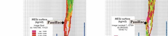
10 SPOT image during low river flow period (July 1996), mean tides SPM concentration (mg/l)


,")

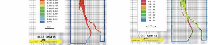
11 Landsat image during high river flow (March 2000), spring tides SPM concentration (mg/l)


12 SPOT image - End of high river flow period (May 2001), mean tides SPM concentration (mg/l)


,")


13 SPOT image Begin of low river flow period (July 2001), mean tides SPM concentration (mg/l)


,")


14 SPOT image - End long low river flow period (August 2001), mean tides SPM concentration (mg/l)
15 Marie Curie Fellowship Application to airborne (CASI) data from the Tamar estuary (UK) Tidal movements of MTZ

16 ERG - RSFLUX Test site: Gironde estuary Optical measurements carried out during regular field campaigns Match-ups with satellite data Assessment of atmospheric corrections Assessment of quantification relationships
")


 -")


")
17 ERG - RSFLUX In-situ data Four (+1) autonomous fixed stations + Regular onboard optical data = In situ database Satellite data - MERIS (1000 m) - MERIS (300 m) - MODIS-AQUA (1000 / 250 / 500 m) - MODIS-TERRA (1000 / 250 / 500 m) - ASTER (~25 m) - Hyperion (~25 m) First results obtained using MODIS-AQUA data
18 Integration into a 3D sediment transport model Model: SiAM3D- Gironde Developped by IFREMER (DEL/EC P. LeHir) Method: - Adapted to the Gironde estuary (Sottolichio et al. (2000) Vos, R.J., Brummelhuis, P.J.G. and Gerritsen, H., Integrated data-modelling approach for suspended sediment transport in a regional scale. Coastal Eng., 41: Minimise differences between SPM concentrations observed and calculated by the model by fitting the model pârameters Objectives: To calibrate and validate the model To develop an operational monitoring system for estuarine waters: - Understand sediment transport processes involved - Quantify then forecast sedimentary fluxes - Manage human activities (e.g. dredging) shoreline, harbour constructions


19 Example of satellite data interation into the SiAM3D-Gironde model
20 First Conclusions - Plans MERIS + MODIS FR data = great potential to study estuaries MERIS = multi-spectral data (ATMc,SPM, CDOM, Chla) but access and repetitivity? MODIS = easy access, 2 sensors (2 images / day) but only 2 bands (SPM) Investigation of IOPs in turbid waters (measurements + simulations) Assessment of atmospheric corrections Processing of numerous MERIS / MODIS images for comparison
Estimation of chlorophyll-a concentration in estuarine waters:
 Estimation of chlorophyll-a concentration in estuarine waters: case study of the Pearl River estuary Yuanzhi Zhang *, Chuqun Chen #, Hongsheng Zhang *, Xiaofei*, Chen Guiying Chen# *Institute of Space
Mapping estuarine turbidity using high and medium resolution time series imagery
 Mapping estuarine turbidity using high and medium resolution time series imagery Virginie Lafon Arthur Robinet Tatiana Donnay David Doxaran Bertrand Lubac Eric Maneux Aldo Sottolichio Olivier Hagolle Alexandra
USE OF THE NEW OLCI AND SLSTR BANDS FOR ATMOSPHERIC CORRECTION OVER TURBID COASTAL AND INLAND WATERS
 USE OF THE NEW AND SLSTR BANDS FOR ATMOSPHERIC CORRECTION OVER TURBID COASTAL AND INLAND WATERS Kevin Ruddick and Quinten Vanhellemont Royal Belgian Institute for Natural Sciences (RBINS), Operational
Inland and coastal water quality retrieval Some challenges and new opportunities
 Inland and coastal water quality retrieval Some challenges and new opportunities Els Knaeps, Dries Raymaekers, Sindy Sterckx (VITO, Belgium) Kevin Ruddick, Bouchra Nechad (MUMM, Belgium) Ana Dogliotti
Appendix A. Proposal Format. HICO Data User s Proposal
 Appendix A. Proposal Format HICO Data User s Proposal Title of Proposal: A hyperspectral atmospheric correction algorithm to retrieve water-leaving radiance signal from HICO data Principal Investigator
Zu-Tao Ou-Yang Center for Global Change and Earth Observation Michigan State University
 Zu-Tao Ou-Yang Center for Global Change and Earth Observation Michigan State University Ocean Color: Spectral Visible Radiometry Color of the ocean contains latent information on the water qualitycdom,
EVALUATION OF TWO SITES FOR OCEAN COLOR VALIDATION IN THE TURBID WATERS OF THE RÍO DE LA PLATA (ARGENTINA)
") EVALUATION OF TWO SITES FOR OCEAN COLOR VALIDATION IN THE TURBID WATERS OF THE RÍO DE LA PLATA (ARGENTINA) Dogliotti, A. I. (1), Gossn, J. I. (1), Vanhellemont, Q. (2), Ruddick, K.G. (2) (1) (2) Instituto
EVALUATION OF TWO SITES FOR OCEAN COLOR VALIDATION IN THE TURBID WATERS OF THE RÍO DE LA PLATA (ARGENTINA) Dogliotti, A. I. (1), Gossn, J. I. (1), Vanhellemont, Q. (2), Ruddick, K.G. (2) (1) (2) Instituto
Monitoring water quality of the Southeastern Mediterranean sea using remote sensing
 Monitoring water quality of the Southeastern Mediterranean sea using remote sensing Tamir Caras The Remote Sensing Laboratory Jacob Blaustein Institutes for Desert Research Ben-Gurion University of the
Future remote sensors for chlorophyll a. Dimitry Van der Zande, Quinten Vanhellemont & Kevin Ruddick
 Future remote sensors for chlorophyll a Dimitry Van der Zande, Quinten Vanhellemont & Kevin Ruddick Workshop Scheldt Commission: eutrophication 20 th October 2016 Ocean colour from space ESA MERIS 7 May
Airborne Hyperspectral Potential for Coastal Biogeochemistry of the Scheldt Estuary and Plume
 Airborne Hyperspectral Potential for Coastal Biogeochemistry of the Scheldt Estuary and Plume M. Shimoni & M. Acheroy Signal and Image Centre, Royal Military Academy; D. Sirjacobs & S. Djenidi GeoHydrodynamic
Water property monitoring and assessment for China s inland Lake Taihu from
 Water property monitoring and assessment for China s inland Lake Taihu from MODIS-Aqua measurements By Wang M, W Shi and J Tan, Remote Sensing of Environment 115 (2011) 841-854 Wei Wang 9 December 2011
Optical classification in contrasted coastal waters for monitoring water masses and improving the assessment of ocean color products
 Optical classification in contrasted coastal waters for monitoring water masses and improving the assessment of ocean color products Vantrepotte V., Loisel H., Mériaux X., and Dessailly D. LOG, CNRS-UMR
METODOLOGIE E APPROCCI PER OSSERVAZIONI IPERSPETTRALI IN ACQUE COSTIERE E INTERNE
 Data Exploitation della missione PRISMA, precursore delle missioni iperspettrali nazionali Roma, 1-3 marzo 2017 METODOLOGIE E APPROCCI PER OSSERVAZIONI IPERSPETTRALI IN ACQUE COSTIERE E INTERNE Federica
Application of Geostationary Satellite Images to the monitoring of dynamic variations
 The 1 st International Ocean Colour Science Meeting Darmstadt, Germany, 6-8 May 2013 Application of Geostationary Satellite Images to the monitoring of dynamic variations Jong-Kuk Choi, Young Je Park and
Ocean Diurnal Variations Measured by the Korean Geostationary Ocean Color Imager
 Ocean Diurnal Variations Measured by the Korean Geostationary Ocean Color Imager Menghua Wang 1, Lide Jiang 1,2, Seunghyun Son 1,2, & Wei Shi 1,2 1 NOAA/NESDIS Center for Satellite Applications & Research
OCEAN COLOR PRODUCTS RETRIEVAL AND VALIDATION AROUND CHINA COAST WITH MODIS
 OCEAN COLOR PRODUCTS RETRIEVAL AND VALIDATION AROUND CHINA COAST WITH MODIS L. Sun a, M. Guo b, X. Wang b a National Satellite Meteorological Center, China Meteorological Administration, No.46 South Avenue
 Fernando Gilbes 1, William Hernández, Natlee Hernández, José Martínez, and Vilmaliz Rodriguez Geological and Environmental Remote Sensing Lab Department of Geology University of Puerto Rico at Mayagüez
USING MERIS DATA FOR THE RETRIEVAL OF CHL A, CDOM AND TSS VALUES IN THE GULF OF FINLAND AND LAKE LOHJANJÄRVI
 USING MERIS DATA FOR THE RETRIEVA OF CH A, CDOM AND TSS VAUES IN THE GUF OF FINAND AND AKE OHJANJÄRVI Sampsa Koponen 1, Jenni Vepsäläinen 2, Jouni Pulliainen 1, Kari Kallio 2, Timo Pyhälahti 2, Antti indfors
Satellite based inland and coastal water quality monitoring
 Satellite based inland and coastal water quality monitoring Harmonized transnational, long-term and near-real time space based solutions. Thomas Heege CEO EOMAP Germany Earth Observation & Mapping Inland
Assessment of Suspended Sediments Concentration in Surface Waters, Using Modis Images
 American Journal of Applied Sciences 5 (7): 798-804, 2008 ISSN 1546-9239 2008 Science Publications Assessment of Suspended Sediments Concentration in Surface Waters, Using Modis Images Mobasheri Mohammad
Synergy between polar-orbiting and geostationary sensors:
 Synergy between polar-orbiting and geostationary sensors: Remote sensing of the ocean at high spatial and high temporal resolution. Quinten Vanhellemont, Griet Neukermans, Kevin Ruddick Management Unit
NASA Workshop for Remote Sensing of Coastal & Inland Waters
 NASA Workshop for Remote Sensing of Coastal & Inland Waters Madison, Wisconsin June 20-22, 2012 Dr. Robert Shuchman, MTRI George Leshkevich, NOAA GLERL Contributors: Michael Sayers, MTRI Colin Brooks,
Measuring Ocean Color: The Basics
 Measuring Ocean Color: The Basics Radiation of energy from the Sun and the Earth s surface. Recall from previous lectures that the Sun (6000 K), radiates energy in three portions of the energy spectrum:
ANALYZING THE SPATIAL AND TEMPORAL VARIABILITY OF WATER TURBIDITY IN THE COASTAL AREAS OF THE UAE USING MODIS SATELLITE DATA
 ANALYZING THE SPATIAL AND TEMPORAL VARIABILITY OF WATER TURBIDITY IN THE COASTAL AREAS OF THE UAE USING MODIS SATELLITE DATA Muna R. Al Kaabi, Jacinto Estima and Hosni Ghedira Ocean Color Group - Earth
Great Lakes Remote Sensing Algorithms
 Great Lakes Remote Sensing Algorithms Status, Comparisons, and Future Directions Robert Shuchman MTRI Mike Sayers MTRI George Leshkevich NOAA/GLERL Barry Lesht JGLR/Assoc. Editor Caren Binding Environment
A Unified Approach to Remote Estimation of Chlorophyll a Concentration in Complex Inland, Estuarine, and Coastal waters
 A Unified Approach to Remote Estimation of Chlorophyll a Concentration in Complex Inland, Estuarine, and Coastal waters Wesley J. Moses 1, *, Anatoly A. Gitelson 1, Alexander A. Gilerson 2, and Daniela
Remote Sensing of Environment
 Remote Sensing of Environment 115 (2011) 1617 1631 Contents lists available at ScienceDirect Remote Sensing of Environment journal homepage: www.elsevier.com/locate/rse Spectral variations in the near-infrared
A RIGOROUS METHOD TO RETRIEVE TSM CONCENTRATIONS FROM MULTI-TEMPORAL SPOT IMAGES IN HIGHLY - TURBID COASTAL WATERS
 A RIGOROUS METHOD TO RETRIEVE TSM CONCENTRATIONS FROM MULTI-TEMPORAL SPOT IMAGES IN HIGHLY - TURBID COASTAL WATERS Hans van der Woerd and Reinold Pasterkamp Institute for Environmental Studies (IVM), Vrije
Study of Water Quality using Satellite data
 2nd Workshop on Parameterization of Lakes in Numerical Weather Prediction and Climate Modelling Study of Water Quality using Satellite data M. Potes, M. J. Costa (Évora Geophysics Centre, PORTUGAL) This
Diurnal variability of turbidity and light attenuation in the southern North Sea from the geostationary SEVIRI sensor
 Publication in review in Remote Sensing of the Environment Diurnal variability of turbidity and light attenuation in the southern North Sea from the geostationary SEVIRI sensor Griet Neukermans 1,2 Kevin
Harmful Algal Blooms (HABs) 2 methods
 2 methods") Harmful Algal Blooms (HABs) 2 methods Richard P. Stumpf NOAA, National Ocean Service HAB occurrences worldwide Image from whoi.edu/redtide Remote Sensing for HAB Detection: Does the Bloom Change Water
Harmful Algal Blooms (HABs) 2 methods Richard P. Stumpf NOAA, National Ocean Service HAB occurrences worldwide Image from whoi.edu/redtide Remote Sensing for HAB Detection: Does the Bloom Change Water
Ocean Color - Simultaneous Marine and Aerosol Retrieval Tool (OC-SMART)
") Ocean Color - Simultaneous Marine and Aerosol Retrieval Tool (OC-SMART) Yongzhen Fan, Nan Chen, Wei Li, and Knut Stamnes Light and Life Laboratory, Stevens Institute of Technology, Hoboken, NJ, USA OC-SMART
Ocean Color - Simultaneous Marine and Aerosol Retrieval Tool (OC-SMART) Yongzhen Fan, Nan Chen, Wei Li, and Knut Stamnes Light and Life Laboratory, Stevens Institute of Technology, Hoboken, NJ, USA OC-SMART
Operational MODIS Satellite based water turbidity monitoring for dredging operations in Woodside
 DRAFT Operational MODIS Satellite based water turbidity monitoring for dredging operations in Woodside Peter Hausknecht, Woodside - GTO - Geomatics OGP Remote Sensing workshop held at European Space Agency
Application of OCEANSAT-2 2 data to study the CASE- 2 waters in the North-Eastern Mediterranean sea (NEMO-C2W)
") Application of OCEANSAT-2 2 data to study the CASE- 2 waters in the North-Eastern Mediterranean sea (NEMO-C2W) IIA PI: Stefano Pignatti Italian National Research Council Atmospheric Pollution E-mail: rosa.cavalli@lara.rm.cnr.it
Application of OCEANSAT-2 2 data to study the CASE- 2 waters in the North-Eastern Mediterranean sea (NEMO-C2W) IIA PI: Stefano Pignatti Italian National Research Council Atmospheric Pollution E-mail: rosa.cavalli@lara.rm.cnr.it
Global Processing and Products from MERIS Full Resolution Data for the Coastal Zone. User Consultation Meeting
 Global Processing and Products from MERIS Full Resolution Data for the Coastal Zone User Consultation Meeting 16-17.11.2010 Frascati CoastColour UCM1 * Frascati * 16.- 17.11.2010 CoastColour is ESAs initiative
7. Requirements for future ocean color satellite sensors. Menghua Wang, IOCCG Lecture Series Atmospheric Correction
 7. Requirements for future ocean color satellite sensors Significant efforts are needed for improvements of water color products in the inland & coastal regions: Turbid Waters (violation of the NIR black
IEEE GEOSCIENCE AND REMOTE SENSING LETTERS, VOL. 6, NO. 4, OCTOBER X/$ IEEE
 IEEE GEOSCIENCE AND REMOTE SENSING LETTERS, VOL. 6, NO. 4, OCTOBER 2009 845 Satellite Estimation of Chlorophyll-a Concentration Using the Red and NIR Bands of MERIS The Azov Sea Case Study Wesley J. Moses,
NASA Satellite Ocean Color Timeseries
 NASA Satellite Ocean Color Timeseries Bryan Franz and the NASA Ocean Biology Processing Group International Ocean Color Science Meeting 6-8 May 2013 Ocean Biology Processing Group Multi-mission Ocean Color
Remote sensing of total suspended sediment within lakes Onoke and Wairarapa
 Remote sensing of total suspended sediment within lakes Onoke and Wairarapa Introduction Remote sensing can provide synoptic monitoring of water quality and temperature (e.g., Kloiber et al. 2002, Dekker
INHERENT OPTICAL PROPERTIES IN NEW ENGLAND COASTAL WATERS: DECOMPOSITION INTO CONTRIBUTIONS FROM OPTICALLY IMPORTANT CONSTITUENTS
 ABSTRACT INHERENT OPTICAL PROPERTIES IN NEW ENGLAND COASTAL WATERS: DECOMPOSITION INTO CONTRIBUTIONS FROM OPTICALLY IMPORTANT CONSTITUENTS Morrison, J. R. and Sosik, H. M. Woods Hole Oceanographic Institution,
ereefsoptical and biogeochemical model. CSIRO OCEANS AND ATMOSPHERE FLAGSHIP
 ereefsoptical and biogeochemical model. CSIRO OCEANS AND ATMOSPHERE FLAGSHIP 2 Presentation title Presenter name BGC state variables: - 10 dissolved - 22 living particulate - 11 non-living part. -6 epibenthic.
CS229 Project: Identifying Regions of High Turbidity in San Francisco Bay
 CS229 Project: Identifying Regions of High Turbidity in San Francisco Bay Joe Adelson December 11, 2014 Introduction Suspended sediments in oceans, seas, and estuaries shape coastal geography, provide
ASSESSING THE POTENTIAL OF REMOTELY SENSED DATA FOR WATER QUALITY MONITORING OF COASTAL AND INLAND WATERS
 ASSESSING THE POTENTIAL OF REMOTELY SENSED DATA FOR WATER QUALITY MONITORING OF COASTAL AND INLAND WATERS Asif Mumtaz Bhatti, Donald C. Rundquist, Seigo Nasu and Masataka Takagi Research Associate, COE,
MERIS PERFORMANCE IN THE EAST CHINA SEAS: EVALUATION OF ATMOSPHERIC CORRECTION AND OPTICAL INVERSION ALGORITHMS
 MERIS PERFORMANCE IN THE EAST CHINA SEAS: EVALUATION OF ATMOSPHERIC CORRECTION AND OPTICAL INVERSION ALGORITHMS Ming-Xia HE 1, Shuangyan He 1, Lianbo Hu 1, Yunfei Wang 1, Qian Yang 1, Tinglu Zhang 1 Wenzhong
Belair Litora. B E L A I R WO R KS H OP J U N E 1 3, G e m bl o u x, B e l g i um
 Belair Litora B E L A I R WO R KS H OP 2 0 1 4 - J U N E 1 3, 2 0 1 4 G e m bl o u x, B e l g i um E l s k n a e ps, D r i e s R ay m a e ke rs, S i v e e C h a w l a, N i t i n B h a t i a, P i e t e
Operationelles Monitoring von Binnengewässern mit Copernicus und multiplen Satellitensensoren: Regionale und globale Anwendungen
 Operationelles Monitoring von Binnengewässern mit Copernicus und multiplen Satellitensensoren: Regionale und globale Anwendungen Dr. Thomas Heege, EOMAP GmbH & Co.KG, Germany Questions 1) Acceptance of
Satellite Monitoring of Water Quality in Lake Manzalah, Egypt. Real-Time Water Quality Monitoring Workshop June St.
 Satellite Monitoring of Water Quality in Lake Manzalah, Egypt Real-Time Water Quality Monitoring Workshop June 16-17 2009 St. John s, Canada Motivation Lakes are vital component of Egypt s water resources
MERIS VALIDATION WITH RESPECT TO OPERATIONAL MONITORING NEEDS IN THE NORTH AND BALTIC SEA
 MERIS VALIDATION WITH RESPECT TO OPERATIONAL MONITORING NEEDS IN THE NORTH AND BALTIC SEA Kerstin Stelzer (1), Jasmin Geißler (1), Carsten Brockmann (1), Holger Klein (2), Jeanette Göbel (3), Anu Reinart
Development of Carbon Data Products for the Coastal Ocean: Implications for Advanced Ocean Color Sensors
 Development of Carbon Data Products for the Coastal Ocean: Implications for Advanced Ocean Color Sensors Antonio Mannino NASA Goddard Space Flight Center Greenbelt, Maryland USA Field Activities & DOC
An understanding biological variability in the open ocean (GlobCOLOUR project) Dr Samantha Lavender
 Dr Samantha Lavender") An understanding biological variability in the open ocean (GlobCOLOUR project) Dr Samantha Lavender SEOES & Marine Institute, University of Plymouth ARGANS Limited Tamar Science Park, Plymouth s.lavender@plymouth.ac.uk
An understanding biological variability in the open ocean (GlobCOLOUR project) Dr Samantha Lavender SEOES & Marine Institute, University of Plymouth ARGANS Limited Tamar Science Park, Plymouth s.lavender@plymouth.ac.uk
POSSIBILITY OF GCOM-C1 / SGLI FOR CLIMATE CHANGE IMPACTS ANALYZING
 POSSIBILITY OF GCOM-C1 / SGLI FOR CLIMATE CHANGE IMPACTS ANALYZING Y. Honda* a, M. Moriyama b, M. Hori c, M. Murakami c, A. Ono c, K. Kajiwara a a Center for Environmental Remote Sensing (CEReS), Chiba
Application of Gliders for Near-Real Time METOC Data Collection Capability for Battlespace Characterization
 DISTRIBUTION STATEMENT A: Approved for public release; distribution is unlimited. Application of Gliders for Near-Real Time METOC Data Collection Capability for Battlespace Characterization Charles Trees
Trophic state assessment of global large inland waters using the MODIS-derived FUI
 August 2018 Stirling Trophic state assessment of global large inland waters using the MODIS-derived FUI Shenglei Wang Junsheng Li & Bing Zhang Evangelis Spyrakos & Andrew N. Tyler RADI, Chinese Academy
Simultaneous atmospheric correction and quantification of suspended particulate matter in the Guadalquivir estuary from Landsat images
 doi:10.5194/piahs-368-15-2015 Remote Sensing and GIS for Hydrology and Water Resources (IAHS Publ. 368, 2015) (Proceedings RSHS14 and ICGRHWE14, Guangzhou, China, August 2014). 15 Simultaneous atmospheric
Developing the next generation of coastal water quality products and services - the FP7/HIGHROC project
 Developing the next generation of coastal water quality products and services - the FP7/HIGHROC project K. Ruddick, C. Brockmann, E. Capuzzo, K. Collingridge, S. Constantin, V. Créach, L. De Keukelaere,
Future Retrievals of Water Column Bio-Optical Properties using the Hyperspectral Infrared Imager (HyspIRI)
") Remote Sens. 2013, 5, 6812-6837; doi:10.3390/rs5126812 Article OPEN ACCESS Remote Sensing ISSN 2072-4292 www.mdpi.com/journal/remotesensing Future Retrievals of Water Column Bio-Optical Properties using
Remote Sens. 2013, 5, 6812-6837; doi:10.3390/rs5126812 Article OPEN ACCESS Remote Sensing ISSN 2072-4292 www.mdpi.com/journal/remotesensing Future Retrievals of Water Column Bio-Optical Properties using
Richard C. Zimmerman, Victoria J. Hill, John Klinck Michael Dinniman Department Ocean, Earth & Atmospheric Sciences and Center for Coastal Physical
 Richard C. Zimmerman, Victoria J. Hill, John Klinck Michael Dinniman Department Ocean, Earth & Atmospheric Sciences and Center for Coastal Physical Oceanography Old Dominion University Norfolk VA 23529
Note that approval of a data user proposal does not imply Navy S&T financial support.
 HICO Data User Agreement Between the Naval Research Laboratory And The HICO Data User Principal Investigator Issued on: HICO-based water transparency Mapping in Pearl River Estuary (PRE) of South China
FERNANDO GILBES REPORT (Performance period: October 1, 2006 to March 31, 2007)
") FERNANDO GILBES REPORT (Performance period: October 1, 2006 to March 31, 2007) 1. RESEARCH COMPONENT Thrust: Coastal Remote Sensing Area of Research within the Thrust: Bio-optical properties and ocean
FERNANDO GILBES REPORT (Performance period: October 1, 2006 to March 31, 2007) 1. RESEARCH COMPONENT Thrust: Coastal Remote Sensing Area of Research within the Thrust: Bio-optical properties and ocean
CROP STATE MONITORING USING SATELLITE REMOTE SENSING IN ROMANIA
 CROP STATE MONITORING USING SATELLITE REMOTE SENSING IN ROMANIA Dr. Gheorghe Stancalie National Meteorological Administration Bucharest, Romania Content Introduction Earth Observation (EO) data Drought
Characterization of global ocean turbidity from Moderate Resolution Imaging Spectroradiometer ocean color observations
 JOURNAL OF GEOPHYSICAL RESEARCH, VOL. 115,, doi:10.1029/2010jc006160, 2010 Characterization of global ocean turbidity from Moderate Resolution Imaging Spectroradiometer ocean color observations Wei Shi
Water quality of lakes over Europe using Sentinel-2; Atmospheric Correction and Validation
 Water quality of lakes over Europe using Sentinel-2; Atmospheric Correction and Validation Antoine Mangin 1,2, Romain Serra 1, Chloé Chauvin 1, Odile Hembise Fanton d'andon 2 (1) ACRI-HE, France; (2) ACRI-ST,
Coastal Biological Data from Satellite
 Coastal Biological Data from Satellite Joji Ishizaka Nagoya University Institute for Space-Earth Environmental Research (ISEE) jishizaka@nagoya-u.jp GEOSS 2018.10.25 Kyoto Genki Terauchi UNEP/NOWPAP CEARAC,
Ocean Color System Vicarious Calibration: requirements on in situ data and sites
 Ocean Color : requirements on in situ data and sites G. Zibordi Joint Research Centre, Ispra, Italy Several elements are taken from Requirements and Strategies for In Situ Radiometry in Support of Satellite
How are these equations relevant to remotely sensed data? Source: earthsci.org/rockmin/rockmin.html
 Lecture 3 How does light give us information about environmental features Revision Select a different scoop from last week Post the key points as a reaction to http://www.scoop.it/t/env22-52-w2 (need to
Diffuse Attenuation Coefficient of the Photosynthetically Available Radiation (PAR), K d (PAR), for Global Open Ocean and Coastal Waters
, K d (PAR), for Global Open Ocean and Coastal Waters") Diffuse Attenuation Coefficient of the Photosynthetically Available Radiation (PAR), K d (PAR), for Global Open Ocean and Coastal Waters SeungHyun Son 1,2 and Menghua Wang 1 1 NOAA/NESDIS/STAR, E/RA3,
Diffuse Attenuation Coefficient of the Photosynthetically Available Radiation (PAR), K d (PAR), for Global Open Ocean and Coastal Waters SeungHyun Son 1,2 and Menghua Wang 1 1 NOAA/NESDIS/STAR, E/RA3,
SGLI/GCOM-C1. Algorithm Theoretical Basic Document. Ocean net primary productivity (ONPP)
") SGLI/GCOM-C1 Algorithm Theoretical Basic Document Ocean net primary productivity (ONPP) Version 3.3 31 March 2016 PI: Toru Hirawake 1* Co-I: Amane Fujiwara 2, Tomonori Isada 3 and Sei-ichi Saitoh 1, 4
SGLI/GCOM-C1 Algorithm Theoretical Basic Document Ocean net primary productivity (ONPP) Version 3.3 31 March 2016 PI: Toru Hirawake 1* Co-I: Amane Fujiwara 2, Tomonori Isada 3 and Sei-ichi Saitoh 1, 4
INTERANNUAL VARIABILITY OF CHLOROPHYLL CONCENTRATION IN THE EASTERN ARABIAN SEA
 INTERANNUAL VARIABILITY OF CHLOROPHYLL CONCENTRATION IN THE EASTERN ARABIAN SEA A Summer Internship Report BY MS. Satlaj Karanje Under the guidance of Dr. S. Prasanna Kumar Scientist, NIO, Goa Department
MAPPING OF PHOTOSYNTHETIC PIGMENTS IN SPANISH RESERVOIRS
 MAPPING OF PHOTOSYNTHETIC PIGMENTS IN SPANISH RESERVOIRS Ramón Peña-Martínez, José Antonio Domínguez-Gómez, Caridad de Hoyos, Antonio Ruiz-Verdú Centro de Estudios Hidrográficos del CEDEX, Pº Bajo de la
NERC Knowledge Exchange Fellowship: Exploitation of satellite remote sensing for regulation and monitoring of inland water quality
 NERC Knowledge Exchange Fellowship: Exploitation of satellite remote sensing for regulation and monitoring of inland water quality Dr Claire Neil, Biological & Environmental Sciences, University of Stirling
LAND AND WATER - EARTH OBSERVATION INFORMATICS FSP
 Earth Observation for Water Resources Management Arnold Dekker,Juan P Guerschman, Randall Donohue, Tom Van Niel, Luigi Renzullo,, Tim Malthus, Tim McVicar and Albert Van Dijk LAND AND WATER - EARTH OBSERVATION
LSP: using AVHRR NDVI data and from 2003 using MODIS NBAR. Water Quality: using MSS and TM Landsat data and from 2001 using
 Land cover land use change effects on surface water quality: Integrated MODIS and SeaWiFS assessment of the Dnieper and Don River basins and their reservoirs Anatoly A. Gitelson, Wesley Moses & Daniela
Carbon dynamics in inland and coastal ecosystems. Dragon 3 ID 10561
 Carbon dynamics in inland and coastal ecosystems Dragon 3 ID 10561 Project Team Ronghua Ma Hongtao Duan Yuchao Zhang Juhua Luo Lin Chen Steven Loiselle Alessandro Donati Claudio Rossi Project Young Scientists
In situ Requirements for Ocean Color System Vicarious Calibration: A Review
 In situ Requirements for Ocean Color System Vicarious Calibration: A Review Background literature G. Zibordi, Ispra, Italy G.Zibordi, F. Mélin, K.J. Voss, B.C. Johnson, B.A. Franz, E. Kwiatkowska, J.P.
Distribution and Cycling of Dissolved Organic Carbon and Colored Dissolved Organic Carbon on the West Florida Shelf
 Distribution and Cycling of Dissolved Organic Carbon and Colored Dissolved Organic Carbon on the West Florida Shelf Dr. Paula Coble College of Marine Science University of South Florida 10 7 th Ave South
MOBILE BAY. Darius Hixon (Project Lead) Austin Clark Tyler Lynn Manoela Rosa. Monitoring Marsh Conditions in Coastal Alabama. Conservation Initiatives
 Austin Clark Tyler Lynn Manoela Rosa. Monitoring Marsh Conditions in Coastal Alabama. Conservation Initiatives") National Aeronautics and Space Administration MOBILE BAY MOBILE ECOLOGICAL BAY ECOLOGICAL FORECASTING FORECASTING II II Monitoring Marsh Conditions in Coastal Alabama Monitoring Using NASA Marsh Earth
National Aeronautics and Space Administration MOBILE BAY MOBILE ECOLOGICAL BAY ECOLOGICAL FORECASTING FORECASTING II II Monitoring Marsh Conditions in Coastal Alabama Monitoring Using NASA Marsh Earth
OPTICAL DETECTION OF A NOCTILUCA SCINTILLANS BLOOM
 EARSeL eproceedings 6, 2/27 13 OPTICAL DETECTION OF A NOCTILUCA SCINTILLANS BLOOM Barbara Van Mol 1, Kevin Ruddick 1, Rosa Astoreca², YoungJe Park 1 and Bouchra Nechad 1 1. Management Unit of the North
COASTAL GILBES GROUP REPORT (Performance period: April 1, 2007 to August 31, 2007)
") COASTAL GILBES GROUP REPORT (Performance period: April 1, 27 to August 31, 27) RESEARCH COMPONENT Thrust: Remote Sensing of Coastal Waters Project 2: Field measurements in coastal waters for algorithm
COASTAL GILBES GROUP REPORT (Performance period: April 1, 27 to August 31, 27) RESEARCH COMPONENT Thrust: Remote Sensing of Coastal Waters Project 2: Field measurements in coastal waters for algorithm
OPTICAL WATER TYPES & LIMNADES
 Global Observatory of Lake Response to Environmental Change Water Quality Information for the Benefit of Society University of Stirling, 29-31 August 2018 OPTICAL WATER TYPES & LIMNADES V. SPYRAKOS, P
Satellite Remote Sensing of Algal Blooms in the southcentral USA:
 Satellite Remote Sensing of Algal Blooms in the southcentral USA: Landsat 8 based algal and turbidity indices in the Grand Lake watershed Abu Mansaray, Doctoral Candidate Environmental Science Graduate
Bio-Argo / Biogeochemical Argo
 Bio-Argo / Biogeochemical Argo Organisation of the community, future plans Hervé Claustre CNRS-UPMC Laboratoire d Océanographie de Villefranche (LOV) Villefranche-sur-mer, France AST 13, Paris March 2012
Pattern recognition of marine provinces
 International Journal of Remote Sensing Vol. 26, No. 7, 10 April 2005, 1499 1503 Pattern recognition of marine provinces K.-H. SZEKIELDA The Graduate School and University Center, Earth and Environmental
Abstract/Project Summary
 Abstract/Project Summary Four large lakes- Sardis, Enid, Grenada, and the Ross Barnett Reservoir in Mississippi and the Grand Bay at the MS-AL gulf coast serve as important economic and recreational resources
Field Survey and Satellite Validation of Water Quality Parameters of Rivers in the Surroundings of Santo Domingo Metropolitan Area, Dominican Republic
 EMECS 9 (Baltimore, 27 31 August 2011) Field Survey and Satellite Validation of Water Quality Parameters of Rivers in the Surroundings of Santo Domingo Metropolitan Area, Dominican Republic Hiroshima University
Lake transparency: a window into decadal variations in dissolved organic carbon concentrations in Lakes of Acadia National Park, Maine
 Lake transparency: a window into decadal variations in dissolved organic carbon concentrations in Lakes of Acadia National Park, Maine Collin Roesler Department of Earth and Oceanographic Science, Bowdoin
Modeling of Water Quality Parameters in lakes using Hyperspectral Remote sensing Technique
 Volume 02 - Issue 08 August 2017 PP. 55-61 Modeling of Water Quality Parameters in lakes using Hyperspectral Remote sensing Technique *V. Hema Sailaja 1, M. Anji Reddy 2 *1Centre for Environment, Institute
QUALITATIVE ASSESSMENT OF INLAND AND COASTAL WATERS BY USING REMOTELY SENSED DATA
 QUALITATIVE ASSESSMENT OF INLAND AND COASTAL WATERS BY USING REMOTELY SENSED DATA Asif M. Bhatti a, *, Donald Rundquist b, John Schalles c, Mark Steele d, Masataka Takagi e a,e Department of Infrastructure
European Forest Fire Information System (EFFIS) - Rapid Damage Assessment: Appraisal of burnt area maps with MODIS data
 - Rapid Damage Assessment: Appraisal of burnt area maps with MODIS data") European Forest Fire Information System (EFFIS) - Rapid Damage Assessment: Appraisal of burnt area maps with MODIS data Paulo Barbosa European Commission, Joint Research Centre, Institute for Environment
European Forest Fire Information System (EFFIS) - Rapid Damage Assessment: Appraisal of burnt area maps with MODIS data Paulo Barbosa European Commission, Joint Research Centre, Institute for Environment
29682 Roscoff cedex, France. roscoff.fr 2 RDT/DMSI, Ifremer Centre de Brest, Plouzané, France
 High frequency measurements of hydrological and biological parameters in the Western English Channel: Evidence for a Karenia mikimotoi bloom in july 2010 P. Morin 1, Y. Aoustin 2, E. Macé 1, P. Jégou 2,
Workshop on Real-time Coastal Observing Systems for Ecosystem Dynamics and Harmful Algal Blooms
 Oceanography Committee ICES CM 2003/C:15 Report of the Workshop on Real-time Coastal Observing Systems for Ecosystem Dynamics and Harmful Algal Blooms Villefranche-sur-Mer, France 11 21 June 2003 This
Application of Remote Sensing On the Environment, Agriculture and Other Uses in Nepal
 Application of Remote Sensing On the Environment, Agriculture and Other Uses in Nepal Dr. Tilak B Shrestha PhD Geography/Remote Sensing (NAPA Member) A Talk Session Organized by NAPA Student Coordination
Monitoring turbidity in Tampa Bay using MODIS/Aqua 250-m imagery
 Remote Sensing of Environment 109 (2007) 207 220 www.elsevier.com/locate/rse Monitoring turbidity in Tampa Bay using MODIS/Aqua 250-m imagery Zhiqiang Chen, Chuanmin Hu, Frank Muller-Karger Institute for
Measurement of water colour using AVIRIS imagery to assess the potential for an operational monitoring capability in the Pamlico Sound Estuary, USA
 International Journal of Remote Sensing Vol. 30, No. 13, 10 July 2009, 3291 3314 Measurement of water colour using AVIRIS imagery to assess the potential for an operational monitoring capability in the
Optical Detection and Assessment of the Harmful Alga, Karenia brevis
 Optical Detection and Assessment of the Harmful Alga, Karenia brevis Steven E. Lohrenz Department of Marine Science The University of Southern Mississippi 1020 Balch Boulevard Stennis Space Center, MS
CONAE: Missions, Projects and Initiatives for coasts and oceans. Sandra Torrusio
 CONAE: Missions, Projects and Initiatives for coasts and oceans Sandra Torrusio From de Past to the Future... SAC-C SAOCOM SAC-D AQUARIUS SABIAMar SAC-C 2000-2013 80 Km SSS Rain Wind Water Vapor Sea Ice
Dynamic of CDOM in the South Pacific: an application of ocean color remote sensing.
 Dynamic of CDOM in the South Pacific: an application of ocean color remote sensing. Post graduate researcher: Chloé Martias chloe.martias@ird.fr Supervisors : Cécile Dupouy, MIO/IRD Nouméa Marc Tedetti,
Remote Sensing of Water Quality in Wisconsin
 Remote Sensing of Water Quality in Wisconsin 1 Steve Greb, UW-Madison Daniela Gurlin, WDNR ----------------------------------- Wisconsin Lakes Convention April 19 th, 218 MODIS Today website are acquired
Expert Meeting on Crop Monitoring for Improved Food Security, 17 February 2014, Vientiane, Lao PDR. By: Scientific Context
 Satellite Based Crop Monitoring & Estimation System for Food Security Application in Bangladesh Expert Meeting on Crop Monitoring for Improved Food Security, 17 February 2014, Vientiane, Lao PDR By: Bangladesh
Satellite Estimates of Wide-Range Suspended Sediment Concentrations in Changjiang (Yangtze) Estuary Using MERIS Data
 Estuary Using MERIS Data") Estuaries and Coasts (2010) 33:1420 1429 DOI 10.1007/s12237-010-9313-2 Satellite Estimates of Wide-Range Suspended Sediment Concentrations in Changjiang (Yangtze) Estuary Using MERIS Data Fang Shen & Wouter
Estuaries and Coasts (2010) 33:1420 1429 DOI 10.1007/s12237-010-9313-2 Satellite Estimates of Wide-Range Suspended Sediment Concentrations in Changjiang (Yangtze) Estuary Using MERIS Data Fang Shen & Wouter
Evaluation of an In Situ Absorption and Beam Attenuation Meter in Clear Open Ocean Water
 Evaluation of an In Situ Absorption and Beam Attenuation Meter in Clear Open Ocean Water David A. Siegel Institute of Computational Earth System Science University of California at Santa Barbara Santa