Stream Simulation in Very Low Gradient Channels
|
|
|
- Shannon Mitchell
- 6 years ago
- Views:
Transcription
1 University of Massachusetts - Amherst ScholarWorks@UMass Amherst International Conference on Engineering and Ecohydrology for Fish Passage International Conference on Engineering and Ecohydrology for Fish Passage 2014 Jun 9th, 3:30 PM - 3:50 PM Stream Simulation in Very Low Gradient Channels D. Higgins University of Wisconsin - Madison Follow this and additional works at: Higgins, D., "Stream Simulation in Very Low Gradient Channels" (2014). International Conference on Engineering and Ecohydrology for Fish Passage This Event is brought to you for free and open access by the The Fish Passage Community at UMass Amherst at ScholarWorks@UMass Amherst. It has been accepted for inclusion in International Conference on Engineering and Ecohydrology for Fish Passage by an authorized administrator of ScholarWorks@UMass Amherst. For more information, please contact scholarworks@library.umass.edu.

2 Stream Simulation In Very Low Gradient Channels Dale Higgins, Hydrologist Chequamegon-Nicolet National Forest
3 Overview Very low gradient stream simulation design Stream simulation design process Define very low gradient? Site assessment very low gradient Design very low gradient


4 Stream Simulation Design Process Site Assessment Alignment and Profile Bed and Banks Structure Sediment Mobility & Stability

5 Very Low Gradient <0.5% slope Sand bed channel No coarse bedload Natural tailwater provides good Depth and low Velocity for AOP Stream size and culvert length considerations


6 Very low gradient Water Surface Slope ~ 0.1% Tailwater Plunge pool
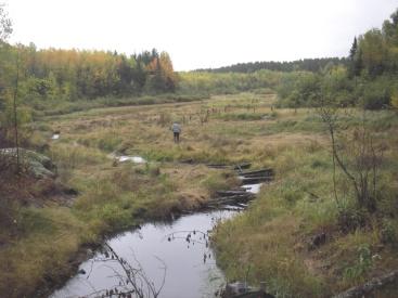
7 Site Assessment Field survey - Profile, profile, profile - And bankfull width Interpret profile for prior impacts


8 Field survey Benchmark Stream profile Stream x-sec (2 up, 2 dn) Road profile (and x-sec) Plan view sketch, or Topo survey w/total station Reference reach bankfull width Geotechnical investigation


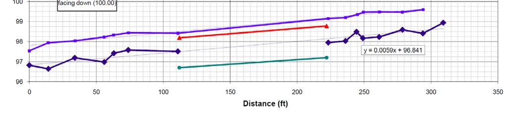
9 Longitudinal Profile Survey: Pool-Run Channel channel widths Streambed in thalweg Water surface, 0.01 ft Every bend & straight Every slope break Every channel width Some bankfull elev. Muck thickness Probe for gravel thalweg


10 Selecting a reference reach for bankfull width measurements Locate an unaffected reach with a straight segment Multiple measurements best at relatively narrow and straight sections.

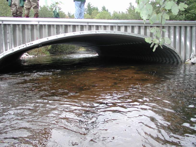
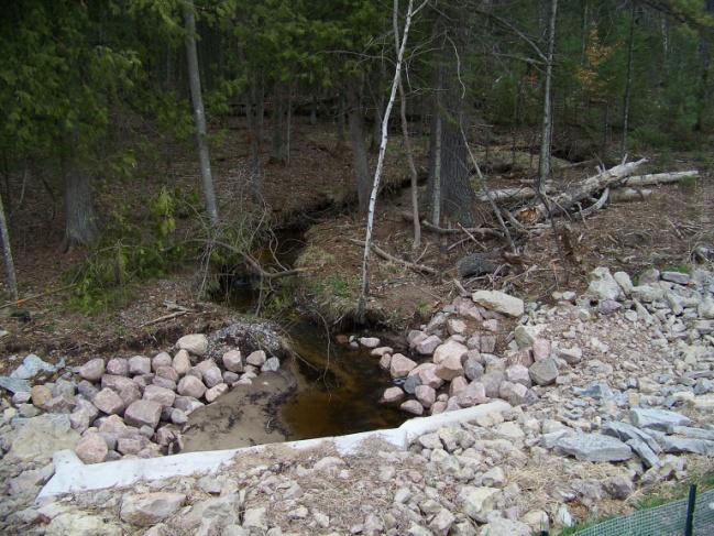
11 Cross section locations Cross floodplain and channel at right angles For some broad, densely vegetated floodplains, obtain the edge from map or aerial photo Avoid hummocks in wetlands Tops grade controls WB Armstrong Crossing


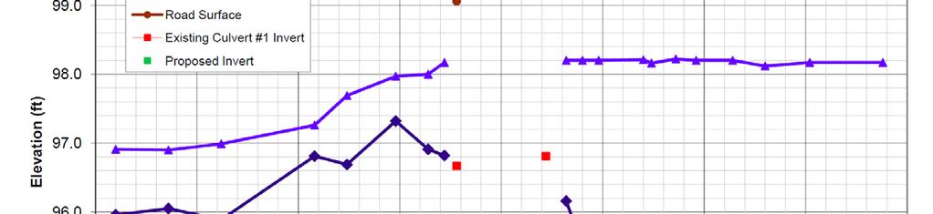
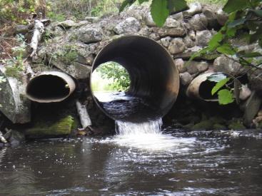
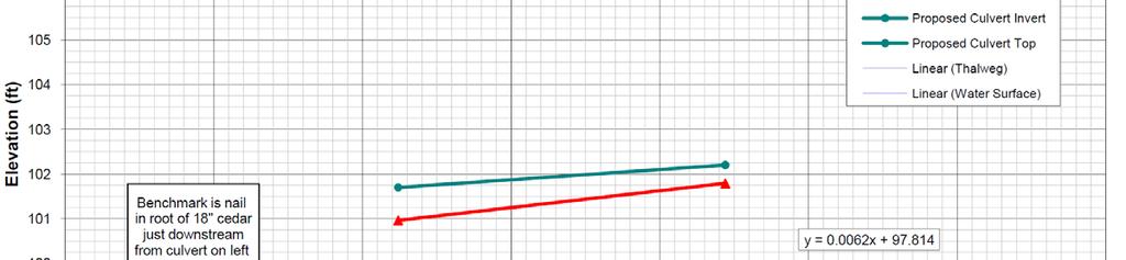
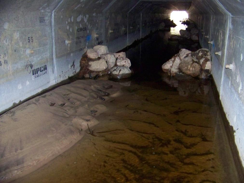
12 Profile interpretation: Upstream ponding and aggradation from undersized culvert set too high Many low gradient streams have slopes of just % Culverts set 1.0 ft high can pond 100 s of feet upstream Channel aggrades with sand and muck


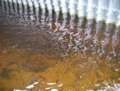
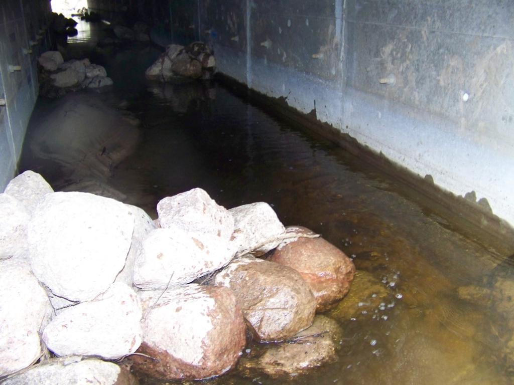
13 Profile interpretation: Upstream ponding and aggradation from undersized culvert set too high and high tailwater control Tailwater control forms at outlet of plunge pool May be above the upstream thalweg May be stable if composed of cobble and gravel tailwater control sand and muck over gravel gravel plunge pool
14 Profile interpretation: upstream ponding and downstream aggradation from frequent failures


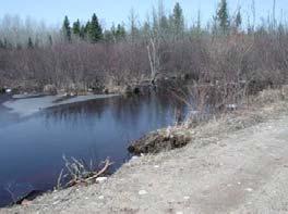
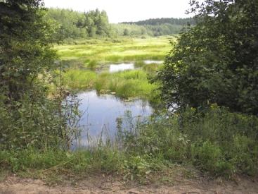
15 Profile and planform interpretation: and high, braided tailwater control Braided tailwater control Stagnant backwater Road gravel deposit Sand and muck
16 Very low gradient stream simulation design Bankfull width (BFW) culvert Set at the proper elevation Natural tailwater control (TWC) provides good Depth and low Velocity for AOP Verified with hydrology and hydraulics Add bars and/or banks (as needed) Stream restoration (as needed)

17 Bankfull Width (BFW) Min = 7.0 feet Mean = 9.2 feet Range = feet, n=6 Drainage Area = 2.25 sq mi BFW (E-Reg Eq) = 8.2 ft Bankfull width culvert Very low gradient stream simulation design Reference Reach Existing Culvert 4.75 x % of BFW
18 Set at the proper elevation Very low gradient stream simulation design

19 Tailwater control Very low gradient stream simulation design Tailwater provides good Depth and low Velocity for AOP Culvert sides act as banks or banks are constructed Allows for natural transport of sand, organics and wood

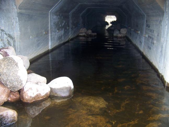
20 Verified with hydrology and hydraulics 57 x38 CMP 68% of Min BFW Very low gradient stream simulation design HW/D= yr water level
21 BFW culvert passes Q 100 with HW/D<1 Very low gradient stream simulation design Stream Profile Hydraulic Analysis Top road 87 x63 Top culvert 500-yr water level 100-yr water level (flood flow estimates from WI regression equations) In N WI watersheds with low flood flows, BFW culverts typically pass the 100-yr discharge with a minor head increase and headwater below the top of culvert.


22 BFW, tailwater control, no bars/banks Very low gradient stream simulation design Drainage Area = 10.6 sq mi BFW Est (E Reg) = 16.5 Min BFW Graph = 12 Brule at FR 2193 Simpson at FR 2386 Elvoy at Rock Dam Road


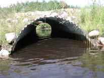
23 If BFW is good, is wider better? Very low gradient stream simulation design Maybe not - in sand bed streams with low flows Without structure to create banks or a thalweg Sand spreads out to create a flat, uniform bed Shallow water may impede passage of some sp. Example of an open-bottom arch in Michigan.


24 Bridge Width = 16 >Bankfull width and sand beds Very low gradient stream simulation design Bridge Width/BFW = 138% Ave BFW = 11.7 Example of bridge on Spring Cr near Durango in SW WI.


25 >Bankfull width and sand beds Very low gradient stream simulation design Culvert Width = 7.0 Ave BFW = 5.0 Culvert Width/BFW = 140% Example of pipe-arch on Unt Marengo R in N WI.

26 Conceptual design for thalweg development Very low gradient stream simulation design Typically bankfull widths Source: Rosgen,1996 (after Williams, 1986)


27 Rock Bars for Thalweg Development NB Oconto W Trib at Hwy 64 Culvert Width = 8.0 ft BFW = 8 ft (ave) Culvert Width/BFW = 100% Culvert Length = 135 ft CL/BFW = wavelength = 8 x10=80 ft 5 bars/wavelength bar spacing=80/5=16 ft total bars=135 /16=8 bars bar spacing adjusted slightly to fit culvert Set tops of bars to match bankfull elevation

28 Rock bars for thalweg development NB Oconto Middle Trib at Hwy 64

29 Rock bars for thalweg development NB Oconto Middle Trib at Hwy 64


30 Rock banks and bars Very low gradient stream simulation design Allow passage of large mammals Torpee Cr at Hwy 32


31 Stream restoration: aggradation Very low gradient stream simulation design


32 Stream restoration: braided channel Very low gradient stream simulation design After Before


33 Stream restoration: cutoff meander Very low gradient stream simulation design Armstrong Cr
34 Summary Very low gradient stream simulation design Site assessment Profile, profile, profile Bankfull width Interpret profile for prior impacts Design Bankfull width culvert Set at proper elevation Natural tailwater control good D low V Verified with hydrology and hydraulics Bars and/or banks (as needed) Stream restoration (as needed)
Stream Restoration at Road Crossings in Northern Wisconsin. Dale Higgins, USDA Forest Service
 Stream Restoration at Road Crossings in Northern Wisconsin Dale Higgins, USDA Forest Service Key Points Large # of road and trail stream crossings on the landscape Many crossings adversely impact streams
Session A3- culvert Design for aquatic organism passage
 University of Massachusetts - Amherst ScholarWorks@UMass Amherst International Conference on Engineering and Ecohydrology for Fish Passage International Conference on Engineering and Ecohydrology for Fish
Designing roads for fish, floods and foxes
 Designing roads for fish, floods and foxes Calculations 9 Swimming Plunging Flow & Leaping Occupied Velocity Prolonged > Capability Yes Swim in Burst Total Time in Burst Time to > Exhaustion Yes Barrier
Hydraulic Modeling with HY-8
 Hydraulic Modeling with HY-8 Linda Hansen PE, PWS MI Dept. of Environmental Quality Water Resources Division UP District Floodplain Engineer Today s Outline What is HY-8? Best Applications & Limitations
Follow this and additional works at:
 University of Massachusetts - Amherst ScholarWorks@UMass Amherst International Conference on Engineering and Ecohydrology for Fish Passage International Conference on Engineering and Ecohydrology for Fish
Session A6- Mannings "n" roughness characteristic occurring in semi-smooth turbulent flow of nature- Iike fishways
 University of Massachusetts - Amherst ScholarWorks@UMass Amherst International Conference on Engineering and Ecohydrology for Fish Passage International Conference on Engineering and Ecohydrology for Fish
Concurrent Sessions D: Design and Performance of Roughened Channels - Rock Weir Fish Passage Challenges
 University of Massachusetts - Amherst ScholarWorks@UMass Amherst International Conference on Engineering and Ecohydrology for Fish Passage International Conference on Engineering and Ecohydrology for Fish
Prototype modifications within a flood control channel to improve fish passage in Mill Creek near Walla Walla, WA
 University of Massachusetts - Amherst ScholarWorks@UMass Amherst International Conference on Engineering and Ecohydrology for Fish Passage International Conference on Engineering and Ecohydrology for Fish
Forest Service AOP Policy and Program. John R. Kattell, P.E. Northern Region Structures Engineer
 Forest Service AOP Policy and Program John R. Kattell, P.E. Northern Region Structures Engineer AOP Policy and Program In years past: Aquatic passage to be considered where important and economically feasible.
Tokul Creek Intake Diversion Dam and Fishway Replacement
 University of Massachusetts Amherst ScholarWorks@UMass Amherst International Conference on Engineering and Ecohydrology for Fish Passage International Conference on Engineering and Ecohydrology for Fish
Stream Crossings II: Bridges, Culverts, Flood Resiliency, and Connectivity
 University of Massachusetts Amherst ScholarWorks@UMass Amherst International Conference on Engineering and Ecohydrology for Fish Passage International Conference on Engineering and Ecohydrology for Fish
Case Study 12. Grubbs Concrete Slab Vented Ford
 Appendix A Case Study Case Study. Grubbs Concrete Slab Vented Ford Location North central California. Plumas National Forest. Mount Hough Ranger District. Grizzly Creek. 3 miles west of Bucks Lake, CA.
Hydraulic analysis and risk assessment of a proposed fish barrier for Johnson Creek, Utah.
 University of Massachusetts - Amherst ScholarWorks@UMass Amherst International Conference on Engineering and Ecohydrology for Fish Passage International Conference on Engineering and Ecohydrology for Fish
Stream Simulation Design in High Gradient Channels
 University of Massachusetts Amherst ScholarWorks@UMass Amherst International Conference on Engineering and Ecohydrology for Fish Passage International Conference on Engineering and Ecohydrology for Fish
Massachusetts River and Stream Crossing Standards: Technical Guidelines
 Massachusetts River and Stream Crossing Standards: Technical Guidelines August 6, 2004 INTRODUCTION As long and linear ecosystems, rivers and streams are very important for fish and other wildlife movements,
Stream Restoration Raccoon Creek A Case Study
 Stream Restoration Raccoon Creek A Case Study Restoration of a Degraded Stream System Steven Glickauf Presentation Overview Stream Restoration Raccoon Creek Restoration Site Case Study Existing Conditions
Session C3 - A 10 Year Retrospective Look at the Current Condition and Success of Nature-Like Fishways Installed on Three Maryland Rivers
 University of Massachusetts Amherst ScholarWorks@UMass Amherst International Conference on Engineering and Ecohydrology for Fish Passage International Conference on Engineering and Ecohydrology for Fish
Temporary Watercourse Crossing: Fords
 Temporary Watercourse Crossing: Fords DRAINAGE CONTROL TECHNIQUE Low Gradient Velocity Control Short Term Steep Gradient Channel Lining Medium-Long Term Outlet Control Soil Treatment Permanent [1] [1]
CLAY STREET BRIDGE REPLACEMENT
 HYDROLOGY /HYDRAULICS REPORT. EL DORADO COUNTY CLAY STREET BRIDGE REPLACEMENT Prepared by: Joseph Domenichelli Domenichelli & Associates 1107 Investment Blvd., Suite 145 El Dorado Hills, California 95762
Wisconsin Hydraulic Geometry Regional Curves
 Wisconsin Hydraulic Geometry Regional Curves Marie Peppler and Faith Fitzpatrick, USGS, Middleton, WI Michigan Stream Team Conference Call February 17, 2010 Objectives Develop relations between channel
Use of WARSSS in Stream Restoration and Watershed Planning. Michigan Aquatic Restoration Conference 2015
 Use of WARSSS in Stream Restoration and Watershed Planning Michigan Aquatic Restoration Conference 2015 October 22, 2015 Use of WARSSS in Stream Restoration and Watershed Planning 1. Watershed Management
Amherst. University of Massachusetts - Amherst. Nathaniel Gillespie United State Department of Agriculture, Forest Service
 University of Massachusetts - Amherst ScholarWorks@UMass Amherst International Conference on Engineering and Ecohydrology for Fish Passage International Conference on Engineering and Ecohydrology for Fish
Natural Channel Design and Dead River Case Study Stream Restoration in the Great Lakes Basin: Using In-stream Structures & Natural Channel Design
 Natural Channel Design and Dead River Case Study Stream Restoration in the Great Lakes Basin: Using In-stream Structures & Natural Channel Design January 22, 2013 S. Paige Baker, PE, MLE Presentation Outline
Design and Development of Fish Passage Facilities for Shortnose Sturgeon at a Northeast Hydropower Project
 University of Massachusetts Amherst ScholarWorks@UMass Amherst International Conference on Engineering and Ecohydrology for Fish Passage International Conference on Engineering and Ecohydrology for Fish
Fish Passage Design for Roughened Channels. Pre-Presentation Note
 NOAA 9/23/2010 Science, Service, Stewardship Aaron Beavers Hydraulic Engineer Fish Passage Design for Roughened Channels Northwest Region E.I.T. M.S.C.E. NOAA FISHERIES SERVICE Pre-Presentation Note The
Design and Construction Practices for the Kenyon Mill Step-Pool Nature-like Fishway, Pawcatuck River, Rhode Island
 University of Massachusetts - Amherst ScholarWorks@UMass Amherst International Conference on Engineering and Ecohydrology for Fish Passage International Conference on Engineering and Ecohydrology for Fish
Struggles for Flood Resiliency and AOP in Rhode Island
 University of Massachusetts Amherst ScholarWorks@UMass Amherst International Conference on Engineering and Ecohydrology for Fish Passage International Conference on Engineering and Ecohydrology for Fish
Removal of the Merrimack Village Dam
 University of Massachusetts - Amherst ScholarWorks@UMass Amherst International Conference on Engineering and Ecohydrology for Fish Passage International Conference on Engineering and Ecohydrology for Fish
Chapter 10. Conduit Outlet Structures Introduction General Layout Information
 10.0 Introduction This section addresses the design of culvert outlets, which are typically oriented in-line with the flow in a drainageway, and storm sewer outlets, which are typically oriented perpendicular
Old Mill School Stream Restoration
 Project Overview This conceptual plan restores and stabilizes two consecutive reaches of a highly incised and unstable stream and reconnects them with the floodplain. The restoration reaches are part of
DECISION MEMO USDA FOREST SERVICE (USFS)
") DECISION MEMO USDA FOREST SERVICE (USFS) Lakewood-Laona Ranger District Chequamegon-Nicolet National Forest Oconto County, Wisconsin DECISION I have decided to implement Project, as identified below, and
DECISION MEMO USDA FOREST SERVICE (USFS) Lakewood-Laona Ranger District Chequamegon-Nicolet National Forest Oconto County, Wisconsin DECISION I have decided to implement Project, as identified below, and
Culvert Prioritization Model: Aiding Communities in the Selection of Priority Restoration Projects
 Culvert Prioritization Model: Aiding Communities in the Selection of Priority Restoration Projects Meeting #1 of the Technical Advisory Committee March 18, 2016 1 Press 2 Prepared February 2016 Undersized
Selection of Aquatic Organism Passage Design Methodology Based on Geomorphic Setting, Site Conditions, and Engineering Constraints
 Selection of Aquatic Organism Passage Design Methodology Based on Geomorphic Setting, Site Conditions, and Engineering Constraints Robert Gubernick R.G. USDA Forest Service Region 9 Eastern Region Acknowledgements
Stream Restoration in the Urban Environment Concepts and Considerations
 Stream Restoration in the Urban Environment Concepts and Considerations The Restoration of Our Rivers; October 5, 2012 Matthew A. Van Eps, PE & Sandi J. Formica: Watershed Conservation Resource Center
IMPROVING OUTCOMES FOR STREAM ALTERATION PROJECTS
 IMPROVING OUTCOMES FOR STREAM ALTERATION PROJECTS Bethany Matousek Inland Lakes and Streams Program Coordinator Wetlands, Lakes and Streams Unit DEQ Water Resources Division MatousekB@Michigan.gov 517-243-6421
Session B4- Freshwater fish and aquatic macroinvertebrate biomonitoring of the Eel River Headwaters Restoration sites in Plymouth, Massachusetts
 University of Massachusetts - Amherst ScholarWorks@UMass Amherst International Conference on Engineering and Ecohydrology for Fish Passage International Conference on Engineering and Ecohydrology for Fish
Culvert Prioritization Model: Aiding Communities in the Selection of Priority Restoration Projects
 Culvert Prioritization Model: Aiding Communities in the Selection of Priority Restoration Projects SNHPC Meeting January 24, 2017 1 Undersized Culverts! Culvert Sizes (~7,500 VT culverts) 6,000 5,000 69%
Case Study 5. Willow Creek Concrete Plank Ford
 Appendix A Case Study Case Study. Willow Creek Concrete Plank Ford Location Northeastern California. Plumas National Forest. Willow Creek. miles northwest of Portola, CA, on Spur Road 23N97Y off Forest
Session C7- Building on the $10 million/year H TAP program for culvert mitigation on national forest system lands
 University of Massachusetts - Amherst ScholarWorks@UMass Amherst International Conference on Engineering and Ecohydrology for Fish Passage International Conference on Engineering and Ecohydrology for Fish
LITTLE SHADES CREEK RESTORATION PROJECT CWA Section 319(h) Nonpoint Source Implementation Grant Project Workplan #17 ADEM Contract #C
 Nonpoint Source Implementation Grant Project Workplan #17 ADEM Contract #C") LITTLE SHADES CREEK RESTORATION PROJECT CWA Section 319(h) Nonpoint Source Implementation Grant Project Workplan #17 ADEM Contract #C90593066 PARTNERS Alabama Department of Environmental Management Cawaco
LITTLE SHADES CREEK RESTORATION PROJECT CWA Section 319(h) Nonpoint Source Implementation Grant Project Workplan #17 ADEM Contract #C90593066 PARTNERS Alabama Department of Environmental Management Cawaco
Created by Simpo PDF Creator Pro (unregistered version) Asst.Prof.Dr. Jaafar S. Maatooq
 Asst.Prof.Dr. Jaafar S. Maatooq") Lect.No.9 2 nd Semester Barrages, Regulators, Dams 1 of 15 In order to harness the water potential of a river optimally, it is necessary to construct two types of hydraulic structures, as shown in Figure
Lect.No.9 2 nd Semester Barrages, Regulators, Dams 1 of 15 In order to harness the water potential of a river optimally, it is necessary to construct two types of hydraulic structures, as shown in Figure
Amherst. University of Massachusetts - Amherst. Michael Forty Durham University; Ribble Rivers Trust,
 University of Massachusetts - Amherst ScholarWorks@UMass Amherst International Conference on Engineering and Ecohydrology for Fish Passage International Conference on Engineering and Ecohydrology for Fish
LOW WATER CROSSINGS, fords, or drifts, as they
 Chapter 9 For ords and Low-Water Crossings Keep the ford profile low, armor the driving surface, and protect against scour. LOW WATER CROSSINGS, fords, or drifts, as they are commonly called, can offer
Culvert Sizing procedures for the 100-Year Peak Flow
 CULVERT SIZING PROCEDURES FOR THE 100-YEAR PEAK FLOW 343 APPENDIX A: Culvert Sizing procedures for the 100-Year Peak Flow A. INTRODUCTION Several methods have been developed for estimating the peak flood
Case Study 19. Mill Creek Embedded Box Culvert Vented Ford
 Case Study. Mill Creek Embedded Box Culvert Vented Ford Location Southeast Missouri. Mark Twain National Forest; Houston-Rolla Ranger District. Southeast of Rolla, south of Interstate 44, off of State
Structure Shape Comments Number of Barrels X Width (ft) X Height (ft) Projecting. At Stream Grade Box Arch Pipe Diameter. Wing wall Headwall
 X Height (ft) Projecting. At Stream Grade Box Arch Pipe Diameter. Wing wall Headwall") SDDOT Fish Passage Assessment Work Sheet (Attachment A) PRJ # PCN: Date: Year Constructed: County: Structure Location: Assessed By: Stream Name: Structure Type Structure Shape Comments Number of Barrels
SDDOT Fish Passage Assessment Work Sheet (Attachment A) PRJ # PCN: Date: Year Constructed: County: Structure Location: Assessed By: Stream Name: Structure Type Structure Shape Comments Number of Barrels
Presented By: Scott Peedle US Forest Service
 Presented By: Scott Peedle US Forest Service Huron-Manistee NF Supervisors office Cadillac, MI Manistee National Forest Approximately 500,000 Acres District Offices Baldwin Manistee Huron National Forest
10(a) Bridge and culvert design information
 Bridge and culvert design information") 10(a) Bridge and culvert design information The following information is required to accompany resource consent applications for bridges or culverts on waterways. Please answer all questions if possible.
10(a) Bridge and culvert design information The following information is required to accompany resource consent applications for bridges or culverts on waterways. Please answer all questions if possible.
Session A7 - A Systematic Approach to Improve Passage at Dams Necessary for Recovery of Endangered Atlantic Salmon in Maine
 University of Massachusetts - Amherst ScholarWorks@UMass Amherst International Conference on Engineering and Ecohydrology for Fish Passage International Conference on Engineering and Ecohydrology for Fish
Bridge Planning Updates. Bridge Planning Practitioners Workshop April 2012
 Bridge Planning Updates Bridge Planning Practitioners Workshop April 2012 Bridge Website Bridge Website Bridge Website Bridge Website BPG 11 Stormwater Management at Rural Bridges Released July 2010 Documents
Geneva Dam. Design of a Steep, Temporary, Riprap Ramp
 Geneva Dam Design of a Steep, Temporary, Riprap Ramp A Run-of of-river Dam Analysis for Geneva Dam Credit to: Yu-Chun Su, Ph.D., P.E., CFM David T. Williams. Ph.D., P.E, CFM Presentation Purpose History
ILLINOIS URBAN MANUAL PRACTICE STANDARD TEMPORARY STREAM CROSSING (no.) CODE 975. Source: Hey and Associates, Inc.
 CODE 975. Source: Hey and Associates, Inc.") ILLINOIS URBAN MANUAL PRACTICE STANDARD TEMPORARY STREAM CROSSING (no.) CODE 975 Source: Hey and Associates, Inc. DEFINITION A bridge or culvert crossing installed across a stream or watercourse for short-term
ILLINOIS URBAN MANUAL PRACTICE STANDARD TEMPORARY STREAM CROSSING (no.) CODE 975 Source: Hey and Associates, Inc. DEFINITION A bridge or culvert crossing installed across a stream or watercourse for short-term
Errata sheet for the Connecticut General Permits May 2, 2017
 Errata sheet for the Connecticut General Permits May 2, 2017 The Corps of Engineers, New England District, has compiled this list of corrections and clarifications for the Connecticut General Permits that
MILL CREEK FISH PASSAGE CONCEPTUAL DESIGNS FINAL REPORT
 MILL CREEK FISH PASSAGE CONCEPTUAL DESIGNS FINAL REPORT Prepared for Tri State Steelheaders Contact: Brian Burns 216 N. Roosevelt, PO Box 1375 Walla Walla, WA 99362 Prepared by Waterfall Engineering, L.L.C.
Errata sheet for the Connecticut General Permits March 26, 2019
 Errata sheet for the Connecticut General Permits March 26, 2019 The Corps of Engineers, New England District, has compiled this list of corrections and clarifications for the Connecticut General Permits
Hydraulic Report. County Road 595 Bridge over Mulligan Creek. Prepared By AECOM Brian A. Hintsala, P.E
 Prepared for: Prepared by: Marquette County Road Commission AECOM Ishpeming, MI Marquette, MI 60240279 December 9. 2011 Hydraulic Report County Road 595 Bridge over Mulligan Creek Prepared By AECOM Brian
Penobscot II: Penobscot Habitat Blueprint Barrier Prioritization Tool: Assessing the Ecological Impacts of Barriers in the Penobscot River Basin
 University of Massachusetts Amherst ScholarWorks@UMass Amherst International Conference on Engineering and Ecohydrology for Fish Passage International Conference on Engineering and Ecohydrology for Fish
Bluff Creek One Water
 Bluff Creek One Water The Bluff Creek Watershed has no lakes within its boundaries. As the westernmost watershed within the District, land use changes from agricultural to residential have occurred relatively
3/21/2012. Dave Conkel State Aid Bridge Engineer. Brian Homan State Aid Bridge Plans Engineer
 3/21/2012 Dave Conkel State Aid Bridge Engineer Brian Homan State Aid Bridge Plans Engineer 1 3/21/2012 Check Q100, V100 and drainage area versus up and down stream bridges. Check proposed channel bottom
Channel stability and capacity considerations Ensure that vertical and lateral channel stability is adequate.
 Selecting an appropriate design Stream form and function Diversions should accommodate natural stream geometry and channel dynamics. Evaluate stream width-to-depth ratio, and match these dimensions if
Low Gradient Velocity Control Short Term Steep Gradient Channel Lining Medium-Long Term Outlet Control Soil Treatment Permanent [1]
![Low Gradient Velocity Control Short Term Steep Gradient Channel Lining Medium-Long Term Outlet Control Soil Treatment Permanent [1]](/thumbs/82/86216855.jpg "Low Gradient Velocity Control Short Term Steep Gradient Channel Lining Medium-Long Term Outlet Control Soil Treatment Permanent [1]") Energy Dissipaters DRAINAGE CONTROL TECHNIQUE Low Gradient Velocity Control Short Term Steep Gradient Channel Lining Medium-Long Term Outlet Control Soil Treatment Permanent [1] [1] The design of permanent
Energy Dissipaters DRAINAGE CONTROL TECHNIQUE Low Gradient Velocity Control Short Term Steep Gradient Channel Lining Medium-Long Term Outlet Control Soil Treatment Permanent [1] [1] The design of permanent
Concurrent Sessions A: Dam Removal II - Integrated River and Floodplain Restoration on the Clark Fork River Following Removal of Milltown Dam
 University of Massachusetts - Amherst ScholarWorks@UMass Amherst International Conference on Engineering and Ecohydrology for Fish Passage International Conference on Engineering and Ecohydrology for Fish
Lake Samish Comprehensive Stormwater Plan Capital Improvement Recommendations
 Lake Samish Comprehensive Stormwater Plan Capital Improvement Recommendations drainage. The easement could potentially be used to site a surface water quality treatment facility for the flow. The design
Spatially explicit hydraulic analysis of the effects of whitewater parks on fish passage
 University of Massachusetts - Amherst ScholarWorks@UMass Amherst International Conference on Engineering and Ecohydrology for Fish Passage International Conference on Engineering and Ecohydrology for Fish
Fish Passage Assessment at Road/Stream Crossings Nounan Reach of the Bear River 4/6/2015
 Fish Passage Assessment at Road/Stream Crossings Nounan Reach of the Bear River 4/6/2015 Corey Lyman, Fisheries Biologist Lee Mabey, Forest Fisheries Biologist Caribou-Targhee National Forest RESULTS SUMMARY
2012 Mill Creek Watershed Habitat Assessment Level 3 Project Study Plan Results
 2012 Mill Creek Watershed Habitat Assessment Level 3 Project Study Plan Results Cranberry Run This project study plan was financed through a Sub-grant from the Ohio EPA with funds from the State of Ohio.
South St. Vrain / Hall Meadows Restoration Planning August 20, 2015
 South St. Vrain / Hall Meadows Restoration Planning August 20, 2015 Agenda Introductions Purpose & Goals of Meeting Planning Area Master Plan Restoration Planning: Cost Estimates, Grants, Scope, Timeline
Case Studies III: Skokomish River Ecosystem Restoration Washington State
 University of Massachusetts - Amherst ScholarWorks@UMass Amherst International Conference on Engineering and Ecohydrology for Fish Passage International Conference on Engineering and Ecohydrology for Fish
Temporary Watercourse Crossing: Culverts
 Temporary Watercourse Crossing: Culverts DRAINAGE CONTROL TECHNIQUE Low Gradient Velocity Control Short Term Steep Gradient Channel Lining Medium-Long Term Outlet Control Soil Treatment Permanent Symbol
Case Studies II: Downstream Fish Passage at High Head Dams
 University of Massachusetts - Amherst ScholarWorks@UMass Amherst International Conference on Engineering and Ecohydrology for Fish Passage International Conference on Engineering and Ecohydrology for Fish
MASSACHUSETTS RIVER AND STREAM CROSSING STANDARDS RIVER AND STREAM CONTINUITY PARTNERSHIP. Developed by the
 MASSACHUSETTS RIVER AND STREAM CROSSING STANDARDS Developed by the RIVER AND STREAM CONTINUITY PARTNERSHIP Including: University of Massachusetts Amherst The Nature Conservancy Massachusetts Division of
Hydraulic Report. County Road 595 Bridge over Dead River. Prepared By AECOM Brian A. Hintsala, P.E
 Prepared for: Prepared by: Marquette County Road Commission AECOM Ishpeming, MI Marquette, MI 60240279 December 9, 2011 Hydraulic Report County Road 595 Bridge over Dead River Prepared By AECOM Brian A.
Session C3- A culvert too far: The failed attempt to update state culvert rules in Maine
 University of Massachusetts - Amherst ScholarWorks@UMass Amherst International Conference on Engineering and Ecohydrology for Fish Passage International Conference on Engineering and Ecohydrology for Fish
Hydrotechnical Design Guidelines for Stream Crossings
 Hydrotechnical Design Guidelines for Stream Crossings Introduction Design of stream crossings and other in-stream highway facilities requires estimation of design highwater elevation and mean channel velocity.
Guide to Placement of Wood, Boulders and Gravel for Habitat Restoration
 Guide to Placement of Wood, Boulders and Gravel for Habitat Restoration January 1, 2010 Please Note: This is a final draft, minor changes and revisions may occur. Table of Contents Introduction... 3 Purpose
CHAPTER 7 HYDRAULIC SURVEYS
 CHAPTER 7 HYDRAULIC SURVEYS Chapter Contents Sec. 7.01 Sec. 7.02 Sec. 7.03 Sec. 7.04 Sec. 7.05 Sec. 7.06 Sec. 7.07 Sec. 7.08 Sec. 7.09 Sec. 7.10 Sec. 7.11 Sec. 7.12 Introduction General Topographic Features
Facilities Development Manual
 State of Wisconsin Department of Transportation Facilities Development Manual ORIGINATOR Director, Bureau of Highway Development PROCEDURE 13-25-35 CHAPTER 13 Drainage SECTION 25 Storm Sewer Design SUBJECT
Lessons Learned from the Jocko River Demonstration Project
 Lessons Learned from the Jocko River Demonstration Project Applied Adaptive Management Matt Daniels, P.E. Presentation Objectives Provide a brief overview of the project context. Describe the monitoring
TEMPORARY STREAM DIVERSION
 ILLINOIS URBAN MANUAL PRACTICE STANDARD TEMPORARY STREAM DIVERSION (ft,) CODE 976 (Source: Aukland Regional Council Stream Facts) DEFINITION A temporary channel or pipe used to convey stream flow around
NCS Design Approach. Biology/Ecology Primer. Presented by: Jack Imhof, National Biologist Trout Unlimited Canada
 NCS Design Approach Biology/Ecology Primer Presented by: Jack Imhof, National Biologist Trout Unlimited Canada Biology/Ecology Key biological principles that are applied Need to speak the same language
- Site Location and Conditions. A. Project Location. B. Existing Conditions
 H&H Report - Site Location and Conditions Page 1 of 2 A. Project Location 1. Site Identification District County Mu nicipali ty 06 Bucks Hilltown (Twp) Site MINSI TRAIL S.R. 4019 Section 60M Segment 0050
Case Study 15. Moonlight Crossing Concrete Box Vented Ford
 Appendix A Case Study 15 Case Study 15. Moonlight Crossing Concrete Box Vented Ford Location Northeastern California. Plumas National Forest. On Lights Creek, 8 miles north of Taylorsville, CA., Forest
Treatment Strategies based on Stream Stratification Methodology by W. Barry Southerland Fluvial Geomorphologist, WNTSC, USDA, NRCS
 Treatment Strategies based on Stream Stratification Methodology by W. Barry Southerland Fluvial Geomorphologist, WNTSC, USDA, NRCS Cedar Creek, WA - 2005 Cedar Creek, WA - 2005 Asotin Creek, WA 2005: photo
May 15, Lower Squaw Creek Restoration Public Workshop. for The Friends of Squaw Creek Truckee River Watershed Council Sierra Nevada Conservancy
 Lower Squaw Creek Restoration Public Workshop for The Friends of Squaw Creek Truckee River Watershed Council Sierra Nevada Conservancy Prepared by: Mike Liquori May 15, 2008 Funding for this project has
The Effect of Turbulence in Hydropower Dam Fish Passageways on Pacific Lamprey Passage
 University of Massachusetts - Amherst ScholarWorks@UMass Amherst International Conference on Engineering and Ecohydrology for Fish Passage International Conference on Engineering and Ecohydrology for Fish
Sizing Hydraulic Structures in Cold Regions to Balance Fish Passage, Stream Function, and Operation and Maintenance Cost
 Sizing Hydraulic Structures in Cold Regions to Balance Fish Passage, Stream Function, and Operation and Maintenance Cost Matt Blank, WTI-MSU David Dockery, Wild Rivers Consulting Chrissy Pohl, BPXA 1 Background
WQPBWMSSOP-03 Rev# 01 03/15/2010 FIELD METHODOLOGY FOR THE ASSESSMENT OF TMDL SEDIMENT AND HABITAT IMPAIRMENTS
 WQPBWMSSOP-03 Rev# 01 03/15/2010 FIELD METHODOLOGY FOR THE ASSESSMENT OF TMDL SEDIMENT AND HABITAT IMPAIRMENTS Montana Department of Environmental Quality 1520 East Sixth Avenue Helena, Montana 59620 March
Appendix C, Attachment 4 June 11, Diversion Channel Outlet Hydraulic Modeling RAS and ADH
 Diversion Channel Outlet Hydraulic Modeling RAS and ADH 11 June 2012 1 Contents Introduction... 3 HEC-RAS modeling of Outlet... 3 Transition Structure Geometry... 3 ADH Modeling of Outlet and Floodplain...
Emergency Pumping Plant Fish Protection Screens at California's Red Bluff Diversion Dam
 University of Massachusetts Amherst ScholarWorks@UMass Amherst International Conference on Engineering and Ecohydrology for Fish Passage International Conference on Engineering and Ecohydrology for Fish
Watershed Hydrology: Go with the flow. Greg Jennings, PhD, PE
 Watershed Hydrology: Go with the flow Greg Jennings, PhD, PE jenningsenv@gmail.com Streams What are your CHALLENGES? Hydrology too much water Pollutants upstream and on-site Vegetation wrong plants, wrong
Stream Crossings I: Culvert Baffle Evaluation
 University of Massachusetts - Amherst ScholarWorks@UMass Amherst International Conference on Engineering and Ecohydrology for Fish Passage International Conference on Engineering and Ecohydrology for Fish
APPENDIX A CHECKLIST FOR PREPARATION OF H&H REPORTS
 OFFICE OF STRUCTURES MANUAL ON HYDROLOGIC AND HYDRAULIC DESIGN CHAPTER 3 APPENDIX A CHECKLIST FOR PREPARATION OF H&H REPORTS (SEE ALSO APPENDIX B FOR DESIGN-BUILD PROJECTS) MARCH 2011 MARCH 2011 1 CHAPTER
Adjusted Flood Prone Acres
 Adjusted Flood Prone Acres The flood prone area is defined as the area adjacent to the stream that is innundated or saturated when the elevation of the water is at twice the maximum depth at bankfull stage
RETENTION BASIN EXAMPLE
 -7 Given: Total Tributary Area = 7.5 ac o Tributary Area within Existing R/W = 5.8 ac o Tributary Area, Impervious, Outside of R/W = 0.0 ac o Tributary Area, Pervious, Outside of R/W = 1.7 ac o Tributary
Freight Street Development Strategy
 Freight Street Development Strategy Appendix B: Naugatuck River Floodplain Analysis Freight Street Development Strategy DECEMBER 2017 Page B-1 1.0 NAUGATUCK RIVER FLOODPLAIN AT FREIGHT STREET 1.1 Watershed
No. 6 December, Wisconsin s Forestry Best Management Practices for Water Quality Forest Roads
 No. 6 December, 1995 Wisconsin s Forestry Best Management Practices for Water Quality Forest Roads Steve Holaday, Wisconsin Dept. of Natural Resources, and Jeff Martin, Dept. of Forestry, UW-Madison BMPs
Rascal Goose. Reach 1. Rascal Goose. Reach 2. å å å. Main Goose Pit. Stream Reach 3. Main Goose Pit. Stream Reach 7
 434000 March 16 2014 434200 434400 ± 434600 434800 435000 Goose Lake 7269800 WRSA B 7269800 7270000 433800 GIS # BAC-06-180a 7270000 PROJECT # 0234411-0005 Rascal Goose Reach 1 Main Goose Pit Stream Reach
Holly Swartz and Jason Shirey
 Chapter 105 General Permits for Stream and Wetland Impacts DEP Ch. 105 CONTACTS FOR BERKS COUNTY: Holly Swartz and Jason Shirey What DEP Regulates Under Chapter 105 Waters of the Commonwealth, which includes
Maine s Land Use Regulations and Erosion Control Techniques
 Maine s Land Use Regulations and Erosion Control Techniques Protecting Maine s Air, Land and Water Colin Clark 441-7419 colin.a.clark@maine.gov Tom Gilbert 441-8031 thomas.gilbert@maine.gov Jim Rodrigue