What is a Watershed? Lesson 2 Objectives Materials Background Advance Preparation Procedure
|
|
|
- Clementine Dixon
- 6 years ago
- Views:
Transcription
1 What is a Watershed? Lesson Objectives The student will be able to do the following: Define a watershed Understand and use relief and topographic maps Map a stream course, understanding that water flow downhill Map a watershed boundary Materials Worksheet/Directions for every student Copies of relief maps and topographic for each team or each student, as desired A copy of the watershed map, preferably on overhead, for each team Colored markers or pencils (preferable) Overheads of each map or picture for demonstration (and overhead projector) A map of Hawaii would be useful Background This unit introduces students to the term watershed. The unit reminds students about the law of gravity and builds upon a previous unit on water. Advance Preparation This is an introductory unit and can be done with little advance preparation. Students should have been introduced to water in general, including the locations where water can be found. Each student should have a worksheet. Copies of relief maps and topographic maps can be copied for each student or each team. Copies of the watershed map should be copied for each team, preferably on an overhead. Procedure 1. Building on Unit 1, ask students to remember where water is located. Ask them to call out locations of water and have each student who remembers a location of water draw it on the board. The drawing on the board should include, at a minimum, a cloud, river, and the ocean. 2. Ask students what they think will happen when it rains on the top of a mountain. Write up the possible answers on the board. Students should identify that water will flow down, and ideally they will describe water as flowing downhill. Stress the role of gravity in causing water to flow downhill. 3. Point out that in Hawaii, most water that falls as rain eventually ends up in the ocean. Ask students how that water gets to the ocean. They should identify that most water ends up in a river. (Some also falls directly on the ocean and some seeps underground and then seeps into the ocean.)
2 4. Ask students to think about the Manoa Stream. A map may be useful but is not necessary. Ask students where water in the Manoa Stream comes from and where it goes. You may need to present some leading questions e.g. If it rains in the hill behind the school, where does that water go? If it rains in Kaneohe, does that water come into the Manoa Stream? Students should be able to understand that the water in the Manoa Stream comes from rain in the Manoa area, and not from any other location. 5. Explain that the area around the Manoa Stream is a watershed. Watershed: An area of land where water drains and collects. Break down the word watershed into Water and Shed o Water rainfall, streamflow, water under the ground o Shed 2 uses Shed like a storage shed. A watershed stores water in its ponds and rivers. Shed like water shedding off an umbrella. A watershed is like an umbrella, with water draining from the top (mountains) to the bottom (valley) into the ocean. 6. Explain that in Hawaii, watersheds are surrounded by mountain peaks that surround a valley, with a river coming down the middle of the mountain and running through the valley to the ocean. 7. Explain that every place in Hawaii is a watershed. When it rains somewhere, water must eventually flow down and out to the ocean. 8. Explain that everyone lives in a watershed. Point out that the school is next to the stream. Ask students to think about what happens when it rains (water flows directly to the stream or seeps into the ground and flows to the stream). If the class is advanced, teachers may point to other areas on a Hawaii map and ask what the watershed is. 9. You may want to introduce the concept of Ahupua a (might meet social studies standard?). Note that Ahupua a often followed watershed boundaries, but were not limited to single watersheds. An Ahupua a was a way of dividing land under traditional Hawaiian authority. Ahupua a are lands that go from the mountains to the oceans, often following natural watershed divisions. The Ahupua a was the key unit of land management. 10. Explain that scientists often study watersheds. Ask students why scientists might study an entire watershed, rather than just one point on a stream (ideally they will identify that the watershed is influenced by what is inside it.) Explain that mapping watershed boundaries is important for scientists and for any government agency that manages water. Have students brainstorm why this might be the case. 11. Ask students how scientists/policy makers know where their study location is (e.g. How do scientists know where the watershed is located?). Identify some of the tools that scientists use (relief maps, topographic maps, aerial photographs, computer programs, field work). Use overheads of sample maps to illustrate. 12. Explain that watersheds are based on topographic boundaries, such as ridgelines, valleys (as seen in the form of streams), and coastlines. Demonstrate on one of the overheads (don t show the students too much!). 13. Have students undertake the watershed mapping activity
3 Activities 1. Have students conduct the watershed mapping exercise. a. Each team/student should be given: A blank relief map A topographic map Students may use the internet to find current aerial photographs if desired Each team should have a copy of the watershed boundary map (preferably as an overhead to overlay on their maps). Teachers may choose to distribute these maps after students have finished mapping. b. Using the topographic map, students should identify where they are located. They should then identify the Manoa Stream. c. Students should identify where the Manoa Stream starts (multiple locations) d. Students should identify where the Manoa Stream ends (Ala Wai canal into the ocean at the Ala Moana park) e. Students should then identify what other streams also drain into this same body of water (restrict students to thinking about the Ala Wai Canal) f. On the worksheet, students should list all of the streams draining into the watershed. g. Using the relief map and any other resources for reference, students should then map the boundary of the Ala Wai Canal watershed and map the streams. h. After they are finished mapping the boundary, they should compare their watershed boundaries with the actual boundary. i. Students should finish the worksheet by identifying any problems with watershed mapping and how those problems can be resolved. 2. Have students draw a watershed. 3. Have students write a paragraph explaining what a watershed is. 4. As homework, ask students to go home and think about what happens when it rains on top of their home. Have them draw a picture with arrows explaining where the rain goes after it falls on their home. Other interesting facts Watersheds can be any size. Watershed refers to the any drainage basin. For instance, a dip in the road draining into a storm drain can be a watershed. This small road valley can be contained in a smaller watershed the size of a few blocks. This small watershed can be contained within the drainage valley for a small tributary. Small tributary watersheds are contained within the watershed for a larger river. The entire south side of Hawaii and its many rivers are a watershed for the ocean. The entire state of Hawaii can be classified a watershed for the surrounding ocean areas.

4 Drawing from

5 Drawing from the College of Tropical Agriculture & Human Resources, UH Manoa, Cooperative Extension Service, May 1999.


6 Topographic Map of the Manoa Area Use this map, along with any other resources, to identify the watershed and its streams. Map from

7 Relief or Elevation Map Draw in the boundary of the watershed. Identify the location of streams. Map from

8 Ala Wai Canal Watershed Map Use this map to compare your drawing of a watershed boundary to the real boundary.
9 Name What is a Watershed? In this activity, you will identify the boundary of your watershed, and identify all of the streams that drain the watershed. Directions: Follow each step, and answer each question. 1. Use the topographic map to identify your location and the location of the Manoa Stream. What does a topographic map show? 2. Identify where the Manoa Stream starts (its headwaters) and where it ends. Identify other streams that drain to the same place. Describe where the stream starts. Is there more than one starting location? Where does the Manoa Stream end? (This is the name of your watershed.) Do any other streams drain to the same spot? If so, list them:
10 3. Use the topographic map, the relief map, and any other resources to draw the boundary of the watershed (from question 2) and its streams. What does a relief map show? Draw a sketch of your watershed boundary: 4. Compare your watershed boundary with the actual boundary. How close was your drawing of the watershed to the real watershed? What kind of problems did you have while drawing your watershed? If you were a scientist, how could you make sure you knew where the boundary of the watershed was located?

11
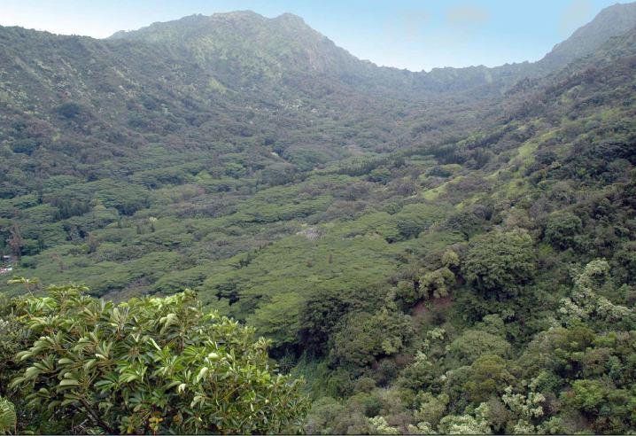
12 Photo from Kokua Kalihi Valley.
2018 NACD POSTER CONTEST Sponsored By: 2018 Theme - Watersheds: Our Water, Our Home. Fact Sheet for Parents and Educators
 Fact Sheet for Parents and Educators What is a Watershed? A watershed is land that sheds water. Water from rain or snow can flow over the land it falls on. The water can flow to a river, lake, stream or
Materials Worksheet, at least one per group or one per student if desired Gold sticky stars Mini chocolate bars or other prizes, if desired
 Land Use and Pollution Scavenger Hunt Lesson 7 --------------------------------------------------------------------------------------------------------------------- Objectives The student will be able
Journey of a Raindrop
 Journey of a Raindrop Grade Level Second to Fourth Duration Prep time: 15 minutes Activity time: 30 to 60 minutes Materials 10 different colored pony beads (from craft stores) 10 large pieces of paper
The Hydrologic Cycle. Floods 3 5. Flood Science LESSON PLAN 1. Key Terms and Concepts. Purposes. Objectives
 LESSON PLAN 1 The Hydrologic Cycle Floods It is important for children to understand the hydrologic cycle in preparation for learning the science behind floods and flash floods. Key Terms and Concepts
BUILDING A WATERSHED MODEL
 BUILDING A WATERSHED MODEL OBJECTIVES Define a watershed and describe how it functions Identify that students live in a watershed within the San Antonio River Basin TOPICS Watersheds Runoff TEKS ALIGNMENT
WHERE DOES THE WATER GO IN THE SAN ANTONIO RIVER BASIN?
 WHERE DOES THE WATER GO IN THE SAN ANTONIO RIVER BASIN? OBJECTIVES Identify the San Antonio River Basin as a system that is a combination of systems Identify the San Antonio River Basin as part of the
When it Rains it Pours
 Lesson Summary: Students will understand how water is absorbed into the ground. They will also be able to explain the difference between pervious and impervious surfaces. Students will also learn about
In this activity, we are going to expand our picture of the water cycle.
 WATER CYCLE Narrative BIG IDEAS: Water is constantly changing form and moving through the earth system. Water changes states as it moves through the water cycle by evaporation, condensation, precipitation,
Water: A Valuable, Yet Limited Resource
 Water: A Valuable, Yet Limited Resource Subject: Science Target Grades 4-5 Duration: One class period Materials per class 3 100-ml graduated cylinders container of water (10-ml/student) Water Cycle with
Stream Reaches and Hydrologic Units
 Chapter United States 6 Department of Agriculture Natural Resources Conservation Service Chapter 6 Stream Reaches and Hydrologic Units Rain clouds Cloud formation Precipitation Surface runoff Evaporation
Reading the River, Summer Watersheds and Streams A unit for 8 th Grade Science. Arthur H. Shutt III. Bullitt Lick Middle School
 Reading the River, Summer 2001 Watersheds and Streams A unit for 8 th Grade Science Arthur H. Shutt III Bullitt Lick Middle School Bullitt County, Kentucky 1 Watersheds and Streams Grade Level: 8 Objectives
UNIT HYDROGRAPH AND EFFECTIVE RAINFALL S INFLUENCE OVER THE STORM RUNOFF HYDROGRAPH
 UNIT HYDROGRAPH AND EFFECTIVE RAINFALL S INFLUENCE OVER THE STORM RUNOFF HYDROGRAPH INTRODUCTION Water is a common chemical substance essential for the existence of life and exhibits many notable and unique
In Your House and in Your Yard, Watch for Water, Be on Guard
 In Your House and in Your Yard, Watch for Water, Be on Guard KEY TERMS Arroyo: A water-carved gully or a normally dry creek found in arid or desert regions. Dam: A barrier built across a river, stream
 Good Morning! Bruce Gilman Department of Environmental Conservation and Horticulture Finger Lakes Community College 3325 Marvin Sands Drive Canandaigua, New York 14424 585-785- 1255 gilmanba@flcc.edu Northern
NATIONAL GEOGRAPHIC EDUCATOR S GUIDE
 NATIONAL GEOGRAPHIC EDUCATOR S GUIDE NEXT GENERATION SCIENCE ALIGNMENTS 1145 17th ST NW Washington, DC Visit us at www.ngchildrensbooks.org Follow us on NGKidsBks E TREME WEATHER Instructional Note The
Flood Plain Functions
 Flood Plain Functions Lesson Abstract Summary: MO GLE: Subject Areas: Students will connect knowledge from previous watershed lessons to understand the functions of flood plains by participating in group
Where Did the Water Go?: Watershed Study Middle School Sample Classroom Assessment
 Where Did the Water Go?: Watershed Study Middle School Sample Classroom Assessment Introduction In this task, students will demonstrate their understanding of the water cycle by considering the inputs
GC2: Components of the Earth System Working Together
 Global Connections: Earth Systems at the Global Scale GC2: Components of the Earth System Working Together Purpose To develop familiarity with interactions among the major components of the Earth system
A Teacher Resource Guide for
 A Teacher Resource Guide for For Grades 3-6 Children s Museum of Virginia Children s Museum of Virginia Lesson Overview The education resource was developed using the 5E model of learning and involves
The water cycle. What is the water cycle? Fact file 2
 Fact file 2 The water cycle The water we use at home and at work comes from the natural environment. It is being recycled all the time in what is called the water cycle. What is the water cycle? Water
What We Are Hoping For: Learning Goals. Runoff Human Impact o A, B, C. Learning Goals:
 LESSON Exploring: Water in Our Lives Introduce how salt moves into waterways by looking at where our water comes from and how runoff impacts the environment. What We Are Hoping For: Learning Goals Runoff
Aquatic Insect Lab Practical
 Aquatic Insect Lab Practical Adapted from: An original Creek Connections activity. Creek Connections, Box 10, Allegheny College, Meadville, Pennsylvania 16335. Background Information Grade Level: Basic,
Water is everywhere on Earth oceans, glaciers, rivers, lakes, air,
 Section 6.1 6.1 Running Water 1 FOCUS Section Objectives 6.1 Explain how the water cycle circulates Earth s water supply in an unending cycle. 6.2 Explain how the water cycle is kept in balance. 6.3 Describe
Watershed Models. Investigative Question: What is a watershed?
 Investigative Question: What is a watershed? Watershed Models Goal: Students build a model to explore watershed characteristics and use the model to learn how landscape characteristics (such as elevation,
Permeability Field Investigation
 Permeability Field Investigation Using the scientific method to guide this outdoor investigation, students test the permeability of different school-ground areas, record and organize the results with maps
Air & Water Lesson 2. Chapter 6 Conserving Our Resources
 Air & Water Lesson 2 Chapter 6 Conserving Our Resources Objectives Summarize the importance of air. Describe the water cycle. Main Idea Living things use air and water to carry out their life processes.
Marine Debris: A Legacy of Litter
 Your web browser (Safari 7) is out of date. For more security, comfort and Activitydevelop the best experience on this site: Update your browser Ignore Marine Debris: A Legacy of Litter What effect is
Aquatic Invasive Species and Their Control Patti Thunell, Edwardsburg Public Schools
 Grade 2 Science, social studies, language arts. Aquatic Invasive Species and Their Control Patti Thunell, pthunell@eps-online.org, Edwardsburg Public Schools Lesson Overview: Students will examine different
Overview of NRCS (SCS) TR-20 By Dr. R.M. Ragan
 TR-20 By Dr. R.M. Ragan") Overview of NRCS (SCS) TR-20 By Dr. R.M. Ragan TR-20 is a computer program for the simulation of runoff occurring from a single storm event. The program develops flood hydrographs from runoff and routes
Overview of NRCS (SCS) TR-20 By Dr. R.M. Ragan TR-20 is a computer program for the simulation of runoff occurring from a single storm event. The program develops flood hydrographs from runoff and routes
Macro Invertebrates STUDENT LEARNING OBJECTIVES
 First Green is an innovative environmental and STEM education outreach program using golf courses as environmental learning labs. Macro Invertebrates Water is essential to all life. Water is a place to
The Carbon Cycle Game A Classroom Activity for Ocean Gazing Episode #16: Antarctica melting
 The Carbon Cycle Game A Classroom Activity for Ocean Gazing Episode #16: Antarctica melting Written by: Kate Florio, Katie Gardner, Liberty Science Center Grade Level: 8-12 Lesson Time: 20-45 min Materials
Watershed: an area or ridge of land that separates waters flowing to different rivers, basins, or seas. It is the interdependent web of living
 Watershed: an area or ridge of land that separates waters flowing to different rivers, basins, or seas. It is the interdependent web of living organisms that inhabit a geographic area and depend on it
Culvert Sizing procedures for the 100-Year Peak Flow
 CULVERT SIZING PROCEDURES FOR THE 100-YEAR PEAK FLOW 343 APPENDIX A: Culvert Sizing procedures for the 100-Year Peak Flow A. INTRODUCTION Several methods have been developed for estimating the peak flood
Appendix B. Storm Drain System Data
 MENIFEE VALLEY CAMPUS MASTER PLAN FINAL EIR MT. SAN JACINTO COMMUNITY COLLEGE DISTRICT Appendix Appendix B. Storm Drain System Data June 2017 MENIFEE VALLEY CAMPUS MASTER PLAN FINAL EIR MT. SAN JACINTO
Module 3. Lecture 4: Introduction to unit hydrograph
 Lecture 4: Introduction to unit hydrograph (UH) The unit hydrograph is the unit pulse response function of a linear hydrologic system. First proposed by Sherman (1932), the unit hydrograph (originally
Water Cycle Diagram To Label
 Diagram To Label Free PDF ebook Download: Diagram To Label Download or Read Online ebook water cycle diagram to label in PDF Format From The Best User Guide Database Have copies of a block diagram (pages
Lesson Five: Best Management Practices for Nonpoint Source Pollution
 Lesson Five: Best Management Practices for Nonpoint Source Pollution Overview This lesson deals with agricultural and urban management practices designed to reduce nonpoint source pollution. Grade Level:
Wisconsin s Buried Treasure
 Wisconsin s Buried Treasure Kevin Masarik Center for Watershed Science and Education Through the University of Wisconsin-Extension, all Wisconsin people can access University resources and engage in lifelong
Awesome Aquifers Vocabulary
 Awesome Aquifers Vocabulary Watershed the region or area drained by a river, stream, etc; drainage area. Aquifer any geologic formation of sand, soil and gravel where groundwater is stored. Pollution the
ACID MINE DRAINAGE TREATMENT IN GREENS RUN BY AN ANOXIC LIMESTONE DRAIN
 ACID MINE DRAINAGE TREATMENT IN GREENS RUN BY AN ANOXIC LIMESTONE DRAIN Introduction Troy Titchenell and Jeff Skousen Anker Energy and West Virginia University From its headwaters in Pocahontas, Randolph
Lesson 2: Introduction to Plot Sampling
 Lesson 2: Introduction to Plot Sampling Review and Introduction Lesson 1 focused on taking a big picture approach and dividing your forest into individual management units called stands. The next step
ACTIVITY 1 - Case Study: A Flooded Community
 WARD S Stormwater Floodplain Simulation System - Lab Activity Name: Group: Date: ACTIVITY 1 - Case Study: A Flooded Community OBJECTIVES: Examine and understand the importance of floodplains. Gain familiarity
TEKS Lesson 7.8C: Effects of Human Activity on Surface Water and Groundwater
 Class ----- Date -------- TEKS Lesson 7.SC TEKS 7.8e Model the effects of human activity on groundwater surface water in a watershed. and TEKS Lesson 7.8C: Effects of Human Activity on Surface Water and
Overview of the Surface Hydrology of Hawai i Watersheds. Ali Fares Associate Professor of Hydrology NREM-CTAHR
 Overview of the Surface Hydrology of Hawai i Watersheds Ali Fares Associate Professor of Hydrology NREM-CTAHR 5/23/2008 Watershed Hydrology Lab 1 What is Hydrology? Hydrology is the water science that
Which careers are expected to have the most job openings in the future, and how will this affect my plans?
 Career Outlook 2 CAREERS The BIG Idea Which careers are expected to have the most job openings in the future, and how will this affect my plans? AGENDA Approx. 45 minutes I. Warm Up: What s a Career Outlook?
Watershed Tarp Activity
 Watershed Tarp Activity Grade Level: 3 rd High School Duration: Prep: 15 minutes Activity: 25-35 minutes Objectives: Students will be able to define a watershed, identify the physical boundary of a watershed
Using the Online Database
 Toxic Site Identification Program Using the Online Database If you ever have a question about a section of the online database, please click on the red question mark [?] next to that section. If that does
Vulnerabilidad y Adaptación a los Extremos Climáticos en las Américas
 Vulnerability and Adaptation to Climate Extremes in the Americas (VACEA) Vulnerabilidad y Adaptación a los Extremos Climáticos en las Américas Principal Ivestigators: Los investigadores principales Dr.
UNIT 1: Introduction and Inquiry Skills (Inquiry skills are to be integrated into all unit of science instruction)
") COURSE: Science GRADE(S): Kindergarten UNIT 1: Introduction and Inquiry Skills (Inquiry skills are to be integrated into all unit of science instruction) SCIENCE THEMES: Systems and interactions, models,
COURSE: Science GRADE(S): Kindergarten UNIT 1: Introduction and Inquiry Skills (Inquiry skills are to be integrated into all unit of science instruction) SCIENCE THEMES: Systems and interactions, models,
WATER LEVELS ON THE GREAT LAKES
 OHSU EP-101 2013 BACKGROUND There is something about the movement of waves against the beach, the sight of a sailboat going past, and the ability to plunge in to the water on a hot summer day that attracts
GROUNDWATER. Narrative
 GROUNDWATER Narrative BIG IDEAS: Groundwater. is between the grains of sand and gravel.. moves because gravity works underground just like it does above ground.. is connected to surface water. 4. is part
ECOSYSTEMS, WATERSHEDS AND POLLUTION CONTROL REVIEW
 ECOSYSTEMS, WATERSHEDS AND POLLUTION CONTROL REVIEW ECOSYSTEMS: (6 th grade content) How biotic and abiotic factors make an ecosystem: https://www.youtube.com/watch?v=mdlwptkg-vi 1. A/An ecosystem is a
Hydrology and Water Management. Dr. Mujahid Khan, UET Peshawar
 Hydrology and Water Management Dr. Mujahid Khan, UET Peshawar Course Outline Hydrologic Cycle and its Processes Water Balance Approach Estimation and Analysis of Precipitation Data Infiltration and Runoff
CSI: Climate Status Investigations-High School
 Triangle Triage Math Background: This lesson is based on the concepts of sustainability. Sustainability is commonly defined as Meeting the needs of current generations without compromising the needs of
7 Energy Flow Through an Ecosystem NOW THAT YOU are familiar with producers and consumers,
 7 Energy Flow Through an Ecosystem NOW THAT YOU are familiar with producers and consumers, you are going to learn about how these organisms interact within an ecosystem. Picture a seal swimming in the
Write It! Station Directions
 Write It! Station Directions It is recommended that you have completed at least two of the following stations before working at this station. -Read It! -Explore It! -Watch It! -Research It! Answer each
EMERGENCY STORAGE PROJECT
 EMERGENCY STORAGE PROJECT San Vicente Pumping Station/Surge Control Facility Carryover Storage and San Vicente Dam Raise EIR/EIS San Vicente Dam Raise Briefing Summary DATE: Oct. 18, 2006 ORGANIZATION:
STORM WATER MANAGEMENT REPORT
 Silvercreek Junction STORM WATER MANAGEMENT REPORT Howitt Creek at the Silvercreek Parkway Site Guelph, Ontario August, 2008 TSH File 22304A-04 August 19, 2008 STORMWATER MANAGEMENT REPORT Howitt Creek
Trends in Illinois River Streamflow and Flooding
 Trends in Illinois River Streamflow and Flooding H. Vernon Knapp, Interim Director Center for Watershed Science Illinois State Water Survey Institute of Natural Resource Sustainability University of Illinois
ginia View Curriculum
 Virg ginia View Curriculum Lesson Plan Grade Level Applicable Virginia SOL Summary Classroom Materials Submitted by Virginia s Water Resources: Aquifers Elementary, Grade 4 Science 4.8a, Virginia Studies
JOB INSTRUCTION. Instructors Guide Session 3
 JOB INSTRUCTION Instructors Guide Session 3 SESSION 3 - INSTRUCTIONS It is important to read this manual and have a clear understanding of the contents, prior to the start of training. Before the session
Module 3 Assessing Climate Change Risk
 Module 3 Assessing Climate Change Risk Page 1 1 s of this module Climate change risk management is an emerging and interdisciplinary process. This module provides a methodology and suite of materials
GIS Applications in Water Resources Engineering
 King Fahd University of Petroleum & Minerals City & Regional Planning Department Introduction to Geographic Information Systems Term Paper Presentation GIS Applications in Water Resources Engineering Prepared
6.0 Runoff. 6.1 Introduction. 6.2 Flood Control Design Runoff
 October 2003, Revised February 2005 Chapter 6.0, Runoff Page 1 6.1 Introduction 6.0 Runoff The timing, peak rates of discharge, and volume of stormwater runoff are the primary considerations in the design
Where did the water you drank today come from? Summary With a roll of the dice, you can simulate the movement of water within the water cycle.
 The Water Cycle Where did the water you drank today come from? Summary With a roll of the dice, you can simulate the movement of water within the water cycle. Objectives Students will learn the complex
Sustainable Stormwater Management: Validating Water Quality and Quantity
 Sustainable Stormwater Management: Validating Water Quality and Quantity Progress Report from University of Virginia November 12, 2008 UVA Undergraduate Student Participants Andrew T. Smith Civil & Environmental
Chehalis Basin Strategy Causes of Extreme Flooding. October 11, 2016 Policy Workshop
 Chehalis Basin Strategy Causes of Extreme Flooding October 11, 2016 Policy Workshop Agenda Hydrology o Precipitation o Flow Climate Change Effects Land Use o Channel straightening and incision o Riparian
A Short Presentation by David Melvin, PLS, CFM
 A Short Presentation by David Melvin, PLS, CFM Based on Florida Statutory Definition recorded in Chapter 381.0065(2)(i) and (k) F.S. with excepts from Florida Department of Health, Interoffice Memorandum,
Vocabulary. 2. Brainstorm What is it? What is it like? What are some examples?
 Vocabulary Name: 1. Write the word to be learned: 2. Brainstorm What is it? What is it like? What are some examples? 3. Graphic Organizer Definition: Reminds me of: Vocabulary Word Sentence: Picture: -----------------------------------------------------------------------------
Theme: Understand Singapore Managing and Protecting Our Environment (Primary 3) The Marina Barrage
 The Marina Barrage") Theme: Understand Singapore Managing and Protecting Our Environment (Primary 3) The Marina Barrage Cheong Chin Fang, Evangeline Ee Minghui, Nabila Banu Binte Mohamed Hassan and Raquel Yeo Ting Hui (Bachelor
Theme: Understand Singapore Managing and Protecting Our Environment (Primary 3) The Marina Barrage Cheong Chin Fang, Evangeline Ee Minghui, Nabila Banu Binte Mohamed Hassan and Raquel Yeo Ting Hui (Bachelor
4.1 Browns Canal Introduction Sub-basin Information
 Section 4 Withlacoochee Basin 4.1 Browns Canal 4.1.1 Introduction The information presented in this sub-basin plan for Browns Canal is intended to provide the reader with information necessary to understand
The Islamic University of Gaza- Civil Engineering Department Sanitary Engineering- ECIV 4325 L5. Storm water Management
 The Islamic University of Gaza- Civil Engineering Department Sanitary Engineering- ECIV 4325 L5. Storm water Management Husam Al-Najar Storm water management : Collection System Design principles The Objectives
RUNOFF FLOWING WATER
 RUNOFF FLOWING WATER Unless otherwise noted the artwork and photographs in this slide show are original and by Burt Carter. Permission is granted to use them for non-commercial, non-profit educational
What is a stormwater utility fee?
 What is a stormwater utility fee? A stormwater utility fee is similar to a water or sewer utility fee. In essence, customers pay a fee to convey stormwater from their properties. The City of Goodlettsville
It s A Jungle Out There Written by Heather Nisbett-Loewenstein January 2014 stonelionpuppettheatre. Teacher s Guide
 Grade Level: PS-3 Subject Areas: Science It s A Jungle Out There Written by Heather Nisbett-Loewenstein January 2014 stonelionpuppettheatre Teacher s Guide Objectives and Goals Science objectives o Students
Introduction. Welcome to the Belgium Study Abroad Program. Courses:
 Introduction Welcome to the Belgium Study Abroad Program Courses: AGSM 335: Soil and Water Management BAEN 460: Principals of Environmental Hydrology BAEN 460 / AGSM 335 Combined lecture and HW sessions
Prepared by Irwin Juckes, PhD (Microbiology), MBA
, MBA") COMMENT ON DRAFT ENVIRONMENTAL IMPACT ASSESSMENT FOR LINKSFIELD MIXED USE INCLUSIONARY DEVELOPMENT (REFERENCE GAUT: 002/13-14/EO153) Prepared by Irwin Juckes, PhD (Microbiology), MBA Table of Contents
COMMENT ON DRAFT ENVIRONMENTAL IMPACT ASSESSMENT FOR LINKSFIELD MIXED USE INCLUSIONARY DEVELOPMENT (REFERENCE GAUT: 002/13-14/EO153) Prepared by Irwin Juckes, PhD (Microbiology), MBA Table of Contents
FIFTH GRADE WATER 1 WEEK LESSON PLANS AND ACTIVITIES
 FIFTH GRADE WATER 1 WEEK LESSON PLANS AND ACTIVITIES WATER CYCLE OVERVIEW OF FIFTH GRADE WATER WEEK 1. PRE: Analyzing why water is important. LAB: Comparing the density of water to that of other liquids.
ENVS 435: Watershed Management. 3 Credits INSTR.: Dr. R.M. Bajracharya
 ENVS 435: Watershed Management 3 Credits INSTR.: Dr. R.M. Bajracharya Unit 1: Introduction - Watershed Concepts Definitions of watershed The elevated line separating the head streams which are tributaries
VOL. 11, issue 1. ron chapple studios / dreamstime.com. cappi thompson / dreamstime.com
 cappi thompson / dreamstime.com ron chapple studios / dreamstime.com VOL. 11, issue 1 A watershed is an area of land containing streams and rivers that all drain into a single larger body of water, such
Traveling Nitrogen DICE CODES AND RESERVOIR STATION SIGNS
 Traveling Nitrogen DICE CODES AND RESERVOIR STATION SIGNS Instructions: 1. 2. 3. 4. 5. Hang these dice codes signs at stations around the classroom. Equip each station with dice and either, a rubber stamp
1. Stream Network. The most common approach to quantitatively describing stream networks was postulated by Strahler (1952).
.") 1. Stream Network The most common approach to quantitatively describing stream networks was postulated by Strahler (1952). First Order Streams streams with no tributaries. Second Order Streams begin at
1. Stream Network The most common approach to quantitatively describing stream networks was postulated by Strahler (1952). First Order Streams streams with no tributaries. Second Order Streams begin at
Attachment 12 Stage 1 Flood Risk Assessment (IE RP-0001)
") IE0311133-22-RP-0001, Issue A 17/10/2013 Attachment 12 Stage 1 Flood Risk Assessment (IE0311133-30-RP-0001) IE0311133-22-RP-0001_A_02.DOC Flood Risk Assessment Celebrating 40 Years in Business Jazz Pharmaceuticals
IE0311133-22-RP-0001, Issue A 17/10/2013 Attachment 12 Stage 1 Flood Risk Assessment (IE0311133-30-RP-0001) IE0311133-22-RP-0001_A_02.DOC Flood Risk Assessment Celebrating 40 Years in Business Jazz Pharmaceuticals
LOT GRADING. LOT GRADING REQUIREMENTS The following lot grading requirements came into effect on May 1, 2007:
 LOT GRADING DEFINITION Lot grading is the reshaping or sloping of the land in such a way that surface drainage from rain runoff is directed away from the buildings and is controlled in a manner that eliminates
Earth Science Chapter 6 Section 1 Review
 Name: Class: Date: Earth Science Chapter 6 Section 1 Review Multiple Choice Identify the choice that best completes the statement or answers the question. 1. What process is illustrated by the arrows labeled
Climate: describes the average condition, including temperature and precipitation, over long periods in a given area
 Ch. 6 - Biomes Section 6.1: Defining Biomes Biome: a group of ecosystems that share similar biotic and abiotic conditions, large region characterized by a specific type of climate, plants, and animals
Application of SWAT Model in land-use. change in the Nile River Basin: A Review
 Application of SWAT Model in land-use change in the Nile River Basin: A Review By: Marwa Ali, Okke Batelaan and Willy Bauwens 15-6-2011 Application of SWAT Model in land-use 1 change in the Nile River
Heating Earth Surfaces
 Heating Earth Surfaces 55 40- to 2-3 50-minute sessions ACTIVITY OVERVIEW L A B O R ATO R Y Students design an experiment to measure how the Sun s energy heats land and water as well as how quickly both
2015 ANNUAL ENGINEERING INSPECTION REPORT ENTERGY INDEPENDENCE PLANT CLASS 3N LANDFILL PERMIT NO S3N-R2 AFIN:
 2015 ANNUAL ENGINEERING INSPECTION REPORT ENTERGY INDEPENDENCE PLANT CLASS 3N LANDFILL PERMIT NO. 0200-S3N-R2 AFIN: 32-00042 JANUARY 15, 2016 ENTERGY INDEPENDENCE PLANT CLASS 3N LANDFILL 2015 ANNUAL ENGINEERING
Team name Ecology Science Olympiad Exam Middle School Level (Division B)
") Team name Ecology Science Olympiad Exam Middle School Level (Division B) You have 50 minutes to complete this test. You may use a non-programmable calculator on this exam. The number of points available
Team name Ecology Science Olympiad Exam Middle School Level (Division B) You have 50 minutes to complete this test. You may use a non-programmable calculator on this exam. The number of points available
Measuring discharge. Climatological and hydrological field work
 Measuring discharge Climatological and hydrological field work 1. Background Discharge (or surface runoff Q s) refers to the horizontal water flow occurring at the surface in rivers and streams. It does
WATER. Name Date. Survey/Posttest
 WATER Date 1. What happens to the level of the water in the straw when the water in the bottle is heated? A. The water level goes down. B. The water level stays the same. C. The water level goes up. Why
Tree Trails. Tree and Forest Health
 TREE TRAILS Tree Trails 7 ELEMENTARY Tree and Forest Health History has shown us the risk of planting too many of the same species in the urban forest. Cities and forests have lost many millions of trees
Reducing Flood Risk in Toronto. David Kellershohn, M.Eng., P. Eng. Toronto Water, City of Toronto
 Reducing Flood Risk in Toronto David Kellershohn, M.Eng., P. Eng. Toronto Water, City of Toronto Institute for Catastrophic Loss Reduction February 19, 2016 1 Agenda Reducing Flood Risk in Toronto 1) Overview
Rock Creek Floodplain Analysis
 Rock Creek Floodplain Analysis www.co.washington.or.us By Jon Franczyk 1996 Flood, www.co.washington.or.us 1996 Flood, www.co.washington.or.us Project Outline Project Goals Introduction Background Study
Water Education for Schools
 Water Education for Schools CLASSROOM & FIELD PRESENTATIONS! The Saving Water Partnership, a collaboration of local water utilities who provide water conservation programs in Seattle and King County, is
INTRODUCTION cont. INTRODUCTION. What is Impervious Surface? Implication of Impervious Surface
 Mapping Impervious Surface Changes In Watersheds In Part Of South Eastern Region Of Nigeria Using Landsat Data By F. I. Okeke Department of Geoinformatics and Surveying, University of Nigeria, Enugu Campus
(this cover page left intentionally blank)
") 4. Siting the Well (this cover page left intentionally blank) 4. Siting the Well Chapter Table of Contents Chapter Table of Contents Chapter Description... 4 Regulatory Requirements Well Siting... 4 Relevant
4. Siting the Well (this cover page left intentionally blank) 4. Siting the Well Chapter Table of Contents Chapter Table of Contents Chapter Description... 4 Regulatory Requirements Well Siting... 4 Relevant
Global Warming and Sea Level Rise
 MATERIALS SUITABLE FOR GRADES 1-8 This activity will show how increased temperatures will hasten the melting of ice in the environment, contributing to a rise in sea level and subsequent flooding of coastal
WONDERFUL, WATERFUL WETLANDS
 WONDERFUL, WATERFUL WETLANDS OBJECTIVES The student will do the following: 1. List characteristics of wetlands. SUBJECTS: Science, Language Arts TIME: 60 minutes 2. Describe the functions of a wetland.