The Sustainability of Floods Pond
|
|
|
- Ezra Pope
- 6 years ago
- Views:
Transcription

1 The Sustainability of Floods Pond Bangor Water District s Public Water Supply Presented By: Rick Pershken Bangor Water District

2 Overview Brief BWD History Watershed Characteristics Lake Characteristics Safe/Sustainable Yield Pumpage & Usage Records Precipitation Records Lake Levels

3 BWD History The Bangor Water District was formed in 1957 Prior to the formation of the Water District, water was supplied by the City of Bangor from a treatment plant located on the Penobscot River March 10, 1951 And while this water is somewhat less vile than that which Philadelphia drinks, it has a noticeable flavor of rotten sawdust and moose tracks.
4 BWD History Initially looked at ground water (Veazie) and surface water sources. Floods Pond in Otis was eventually selected Johnston Pump Station, 5 miles of road, overhead electric and 17 miles of transmission main were constructed for a cost of $4,000,000 (about 32.2 million today) Butler Water Treatment Facility Constructed ($8,000,000) 2013 UV Facility Constructed ($3,000,000)

5 Watershed Map Drainage Area 8.8 square miles (5,632 acres). Topography Hills and lakes, glacial scoured. Soils Glacial till based Dixfield- Colonel-Lyman- Brayton association. Land Use Forested, managed sustainably.
6 Watershed Characteristics Burnt Pond 326 acres, 33 feet deep Little Burnt Pond 10 acres 15 ephemeral and 1 perennial inlet streams Tannery Brook - outlet 1% Wetland Sand & Gravel Aquifers - none 98.7% Owned or Protective Agreement

7 Bedrock Lucerne Granite

8 Lake Characteristics Surface area 756 acres Maximum Depth 142 feet Spillway feet, fixed crest Mean Depth 41 feet Usable Storage 4.5 billion gallons to elevation 282 Temperature 33.2 low, 74.5 High, 50.7 Avg. Quality Coldwater Lake high quality, oligotrophic Secchi Disk 23 to 26 feet/thermocline Biology Arctic Charr. Spawn at Kimball Point on shallow cobble shoal highly susceptible to water level fluctuations
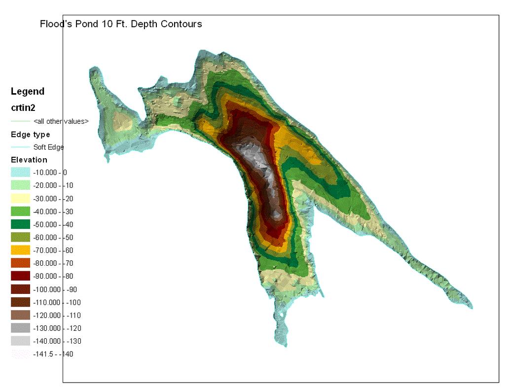
9 Depth Map


10 Charr Sustainability Charr Management Plan (IF&W, BWD) Limit BWD withdrawal to 6 MGD (1990) Limit BWD withdrawal to 6.5 MGD (1991) Withdrawal limit no longer appropriate (1996) IF&W & BWD Joint management of Charr Employ range of alternatives to withdrawal limitations to ensure sustainability of the Charr. Annual monitoring of Charr population. Kimball Point Dec. 2001, Elev /- October, 2009 Elev /-

11 Elevation of Charr Spawning Beds
12 Safe/ Sustainable Yield Difficult to define. Safe yield is more of a maximum drought yield while sustainable yield may be more conservative as it considers maintaining baseflow. The use of the term safe yield is declining.
13 Regulations Chapter 587 In-stream Flows and Lake and Pond Water Levels (2007) establishes river and stream flows and lake and pond water levels to protect natural aquatic life and other designated uses in Maine 's waters Standard Allowable Alteration April 1 to July 31 (1 foot drawdown) August 1 to March 31 (2 foot drawdown) Public Water Utilities - these requirements will not apply to an existing Community Water System operating within its system design capacity providing that (1) the Community Water System, so operating, cannot attain the applicable requirements, and (2) the Community Water System has received, and is operating in accordance with, or is otherwise satisfying the requirements of, a Community Water System Withdrawal Certificate issued by the Department. A Community Water System Withdrawal Certificate will be issued by the Department to any existing Community Water System that demonstrates that it cannot operate at its system design capacity and attain the applicable flow or water level requirements of this chapter. There is also a drought flow variance for Community Water Systems
. Assumed a maximum of 23.5 foot drawdown Results 8.")
14 Safe Yield Black & Veatch (1989) Used a monthly water balance equation; Water In = Water Out +/- Changes in Storage Analyzed for period of March 1948 to February 1952 (2 nd driest period on record). Assumed a maximum of 23.5 foot drawdown Results 8.2 MGD safe yield.
15 Safe Yield Rule of Thumb 1 Square Mile = 1 MGD Average Yield in Maine (MGD) = DA (acres) * 43,560 ft2/acre * 7.48 gal/ft3* 0.5 (APT) / 365 days/year/1,000,000 DA = drainage area (acres) APT = average annual precipitation (feet) Floods Pond average annual yield = 8.8 MGD Drought Yield = 8.8 * 85% = 7.5 MGD 50% = 4.4 MGD The more conservative the more sustainable
; the other 302 feet long at 282.5 feet (23 ).")

16 Johnston Pump Station Two intakes: one 185 feet long at 292 feet (13.5 ); the other 302 feet long at feet (23 ). Four 3,000 GPM x 150 HP, vertical turbine pumps Initial Maximum Design Capacity = 16 MGD. Current Design Capacity 13 MGD (limited by Ozone Treatment Plant 1995).
17 Water Pumped Aug Summer Peaks 5.00 MGD PUMPED Winter Lows 3.77 (Dec.) Oct-97 Nov-99 Dec-01 Jan-04 Feb-06 Mar-08 Apr-10 May-12 Jun-14 Jul-16 DATE
18 Water Pumped as Percentage of Safe Yield (8.2 MGD) 100% 90% 80% 70% 68% 67% PERCENT OF SAFE YIELD 60% 50% 40% 30% 20% 10% 0% Jan-99 Jan-00 Jan-01 Jan-02 Jan-03 Jan-04 Jan-05 Jan-06 Jan-07 Jan-08 Jan-09 Jan-10 Jan-11 Jan-12 Jan-13 DATE
19 Pumped Vs. Metered Water Used Water Pumped WATER USED (MGD) Metered Water YEAR


20 Unmetered/Unaccounted Water Unmetered - Hydrant & Main Flushing Standpipe Draining Process Water Fire Fighting Main Breaks Unaccounted for Leaks we don t know about Unauthorized use or unreported use Measurement inaccuracy

21 Precipitation Average annual precipitation = 42 8 drought periods in the record with the two worst occurring between (Before use as PWS) and between Drought What is It? 85% of average annual precipitation A period of below average water content in streams, reservoirs, ground water aquifers, lakes and soils. a deficit of precipitation sufficient to create stress on and competition for otherwise adequate drinking water supplies Schmitt 2003 Palmer drought severity index is negative 2.0 or less
22 Historical Precipitation % % MONTHLY PRECIPITATION (INCHES) % 100% 80% 60% 40% PERCENTAGE OF AVERAGE ANNUAL PRECIPITATION % 0.0 1/2/1991 1/2/1993 1/3/1995 1/3/1997 1/4/1999 1/4/2001 1/5/2003 1/5/2005 1/6/2007 1/6/2009 1/7/2011 1/7/2013 0%
 =")

23 Lake Levels Natural Outlet Level = New dam lake level (1978) = October, 2001 Level = 301 +/- Steve on the Dam Level = 306 +/- June, 2013
24 Low Lake Levels Floods Pond Lowest Annual Intake Level spillway Feet outlet pipe Natural charr beds New Beds - Down to
25 Lake Levels More Conservative = More Predictable? Spillway Crest LAKE LEVEL (FT) Pipe Outlet /24/01 Record Ground Water Low in Closest USGS Bedrock Well Ground water/surface Water Interaction? /13/ /23/88 9/19/91 6/15/94 3/11/97 12/6/99 9/1/02 5/28/05 2/22/08 11/18/10 8/14/13 5/10/16 DATE
26 The Sustainability of Floods Pond Bangor Water District s Public Water Supply Presented By: Rick Pershken Bangor Water District
27 Partial List of References The Soils of Maine, John A. Ferwerd, Kenneth J. LaFlamme, Norman R. Kalloch, Jr., Natural Resources Conservation Service, USDA and Robert V. Rourke Department of Applied Ecology and Environmental Sciences, University of Maine. Geologic map of the Lucerne Granite, Hancock and Penobscot Counties, Maine Wones, D.R., and Ayuso, R.A. Publishing Organization: U.S. Geological Survey SUSTAINABLE YIELD OF GROUNDWATER Victor M. Ponce May Dina Page, Kathy Moriarty, Data, Photos, Advice. Bangor Water District THE EFFECTS OF THE DROUGHT ON MAINE DRINKING WATER SUPPLIES, DRINKING WATER PROGRAM Department of Health & Human Services Catherine Schmitt January 2005 Management Plan Landlocked Arctic Charr Floods Pond, Otis, Maine, 1996.
The Impacts of Climate Change on Portland s Water Supply
 The Impacts of Climate Change on Portland s Water Supply Richard Palmer and Margaret Hahn University of Washington Department of Civil and Environmental Engineering Joe Dvorak, Dennis Kessler, Azad Mohammadi
San Antonio Water System Mitchell Lake Constructed Wetlands Below the Dam Preliminary Hydrologic Analysis
 San Antonio Water System enhancement. This recommendation was based on limited water quality data provided by SAWS and using a free-water surface constructed wetland with approximately 112 acres of wetted
2016 ANNUAL ICR AND TRR WELL FIELD REPORT ICR WATER USERS ASSOCIATION
 2016 ANNUAL ICR AND TRR WELL FIELD REPORT Prepared for ICR WATER USERS ASSOCIATION Prepared By William Meyer 1 2016 ANNUAL ICR AND TRR WELL FIELD REPORT PURPOSE OF THE REPORT This report is one of an annual
Information Request 11
 Information Request 11 Information Request 11 11-1 Responses to Information Request 11 Response to Information Request 11a Response to Information Request 11b 11-2 11-6 Federal Review Panel Information
Cedar River Watershed Habitat Conservation Plan
 Cedar River Watershed Habitat Conservation Plan Briefing for the WRIA 8 Salmon Recovery Council November 21, 2013 Cyndy Holtz Seattle Public Utilities cyndy.holtz@seattle.gov What is an HCP? Habitat Conservation
John H. Kerr Dam and Reservoir Virginia and North Carolina (Section 216)
") John H. Kerr Dam and Reservoir Virginia and North Carolina (Section 216) Wilmington District, Corps of Engineers Stakeholder Update Presentation January 24, 2014 Authorized under Section 216 of Public
John H. Kerr Dam and Reservoir Virginia and North Carolina (Section 216) Wilmington District, Corps of Engineers Stakeholder Update Presentation January 24, 2014 Authorized under Section 216 of Public
Does Water Resources Management in the Snake River Basin Matter for the Lower Columbia River? Or Is the Snake River Part of Another Watershed?
 Does Water Resources Management in the Snake River Basin Matter for the Lower Columbia River? Or Is the Snake River Part of Another Watershed? John C. Tracy, Director Idaho Water Resources Research Institute
GROUNDWATER DISCHARGE
 GROUNDWATER DISCHARGE C O N N E C T I O N F A C T S H E E T S E R I E S D I S C H A R G E : The movement of groundwater from the subsurface to the surface P E R M E A B I L I T Y : The ability of a material
CHAPTER FIVE Runoff. Engineering Hydrology (ECIV 4323) Instructors: Dr. Yunes Mogheir Dr. Ramadan Al Khatib. Overland flow interflow
 Instructors: Dr. Yunes Mogheir Dr. Ramadan Al Khatib. Overland flow interflow") Engineering Hydrology (ECIV 4323) CHAPTER FIVE Runoff Instructors: Dr. Yunes Mogheir Dr. Ramadan Al Khatib Overland flow interflow Base flow Saturated overland flow ١ ٢ 5.1 Introduction To Runoff Runoff
Engineering Hydrology (ECIV 4323) CHAPTER FIVE Runoff Instructors: Dr. Yunes Mogheir Dr. Ramadan Al Khatib Overland flow interflow Base flow Saturated overland flow ١ ٢ 5.1 Introduction To Runoff Runoff
City of Portsmouth Department of Public Works
 City of Portsmouth Department of Public Works April 7, 2017 Portsmouth Water Supply Status Report Overview The following Portsmouth Water Supply Status Report provides the Portsmouth Water customers an
Hydrology, Water Quality, and Phosphorus Loading of Little St. Germain Lake, Vilas County, Wisconsin
 Hydrology, Water Quality, and Phosphorus Loading of Little St. Germain Lake, Vilas County, Wisconsin Introduction Little St. Germain Lake, which is in Vilas County, Wisconsin, just northeast of St. Germain
Science Supporting Policy: The Case For Flow Quantity
 MassDEP Water Management Program Science Supporting Policy: The Case For Flow Quantity Integrating Water Resources Management UMASS Conference April 8, 2008 Overview Human impact on streamflow and aquatic
Quantification of lake water level influences for Wawasee and Syracuse lakes: Lake and watershed water budgets for 2011, 2012, and 2013
 Quantification of lake water level influences for Wawasee and Syracuse lakes: Lake and watershed water budgets for 2011, 2012, and 2013 Nathan S. Bosch, Joellyn Moine, Margaret Lee, Anna Burke Center for
DES MOINES RIVER RESERVOIRS WATER CONTROL PLAN UPDATES IOWA ASCE WATER RESOURCES DESIGN CONFERENCE
 DES MOINES RIVER RESERVOIRS WATER CONTROL PLAN UPDATES 237 237 237 217 217 217 200 200 200 0 0 0 163 163 163 131 132 122 80 119 27 252 174.59 110 135 120 112 92 56 IOWA ASCE WATER RESOURCES DESIGN CONFERENCE
Los Angeles 3 rd Regional
 Los Angeles 3 rd Regional Investors Conference Los Angeles, California March 31, 2016 Metropolitan Water District of Southern California 1 Metropolitan Water District of of Southern California 2 Metropolitan
Annual Report. December 2010 November Bradley Cole 2/7/2012
 Annual Report December 2010 November 2011 Bradley Cole 2/7/2012 CH2M HILL annual report to the Board of Directors of the Pine-Strawberry Water Improvement District. This annual report provides an overview
ANNUAL PLATTE RIVER SURFACE WATER FLOW SUMMARY
 ANNUAL PLATTE RIVER SURFACE WATER FLOW SUMMARY 4/3/213 Platte River Recovery Implementation Program 213 ANNUAL SURFACE WATER FLOW SUMMARY DRAFT Prepared by staff of the Platte River Recovery Implementation
in the Midsouth Management Chris Henry, Ph.D., P.E. Assistant Professor and Water Management Engineer Merritt McDougal Graduate Research Assistant
 Lessons Pasture Learned / Hay from Irrigation Pump options Monitoring and in the Midsouth Management Chris Henry, Ph.D., P.E. Assistant Professor and Water Management Engineer Merritt McDougal Graduate
Kansas Case Study Kanopolis Reservoir and Salina, KS
 Kansas Case Study Kanopolis Reservoir and Salina, KS Western State Water Council Water Quantity/Quality Workshop October 6, 2015 Mike Tate, P.E. Kansas Department of Health and Environment Kanopolis Reservoir
Ithaca Area Intermunicipal Cooperation NYAWWA Conference. Chris Bordlemay Padilla Cornell University Water Manager 4/27/17
 Ithaca Area Intermunicipal Cooperation NYAWWA Conference Chris Bordlemay Padilla Cornell University Water Manager 4/27/17 Three Water Purveyors in Ithaca Area Cornell University City of Ithaca Bolton Point
November 28, Dear Mr. Bechtold:
 4000 Hollywood Boulevard Seventh Floor, North Tower Hollywood, Florida 33021 (954) 987-0066 Fax: (954) 987-2949 November 28, 2012 Wastewater Compliance and Enforcement Section FLORIDA DEPARTMENT OF ENVIRONMENTAL
Lecture 9A: Drainage Basins
 GEOG415 Lecture 9A: Drainage Basins 9-1 Drainage basin (watershed, catchment) -Drains surfacewater to a common outlet Drainage divide - how is it defined? Scale effects? - Represents a hydrologic cycle
Overview of the Surface Hydrology of Hawai i Watersheds. Ali Fares Associate Professor of Hydrology NREM-CTAHR
 Overview of the Surface Hydrology of Hawai i Watersheds Ali Fares Associate Professor of Hydrology NREM-CTAHR 5/23/2008 Watershed Hydrology Lab 1 What is Hydrology? Hydrology is the water science that
Over 150 Years of Irrigation Implications for Montana s Water Resources
 Over 150 Years of Irrigation Implications for Montana s Water Resources Alters hydrographs Water storage; recharge Changes timing of flow Ginette Abdo Montana Bureau of Mines and Geology March 10, 2016
Urbanization effects on the hydrology of the Atlanta area, Georgia (USA)
") 14/06/01 Impact of Human Activity on Groundwater Dynamics (Proceedings of a symposium held during the Sixth IAHS Scientific Assembly at Maastricht, The Netherlands, July 2001). IAHS Publ. no. 269, 2001.
14/06/01 Impact of Human Activity on Groundwater Dynamics (Proceedings of a symposium held during the Sixth IAHS Scientific Assembly at Maastricht, The Netherlands, July 2001). IAHS Publ. no. 269, 2001.
NORTH TEXAS MUNICIPAL WATER DISTRICT EAST FORK RAW WATER SUPPLY PROJECT
 NORTH TEXAS MUNICIPAL WATER DISTRICT EAST FORK RAW WATER SUPPLY PROJECT Denise Hickey Agenda NTMWD Background Water Planning East Fork Raw Water Supply Project Overview Benefits Nature Center NTMWD BACKGROUND
United Water Conservation District November 2016 Hydrologic Conditions Report 2017 Water Year. December 6, 2016
 United Water Conservation District November 216 Hydrologic Conditions Report 217 Water Year December 6, 216 Page Intentionally Left Blank PRECIPITATION (INCHES) PRECIPITATION (INCHES) PRECIPITATION (INCHES)
Recent Developments in Water Withdrawal Management
 Recent Developments in Water Withdrawal Management Frank Ruswick David A. Hamilton Michigan Department of Environmental Quality Overview What Water Withdrawals are regulated? Water Withdrawal Assessment
1 Exam Prep Chapter 64E -6 Questions and Answers
 1 Exam Prep Chapter 64E -6 Questions and Answers Part One 1. According to Florida Rules: Chapter 64E-6, if building construction has commenced, for how many additional days past the eighteen month expiration
Water Education Foundation Briefing Water Year 2016: San Joaquin Valley Groundwater Conditions
 Groundwater in Fractured Rock Aquifers Well Location, Yield, and Sustainability Water Education Foundation Briefing Water Year 2016: San Joaquin Valley Groundwater Conditions John Kirk, PG, CEG, CHG Engineering
SURFACE WATER WITHDRAWALS & LOW FLOW PROTECTION POLICY MICHAEL COLLEGE, P.E. SUSQUEHANNA RIVER BASIN COMMISSION
 SURFACE WATER WITHDRAWALS & LOW FLOW PROTECTION POLICY MICHAEL COLLEGE, P.E. SUSQUEHANNA RIVER BASIN COMMISSION SCENARIOS Direct withdrawal from surface water (SW): PA MOU w/padep NY MOU w/nysdec MD No
Northern Arizona Hydrogeology
 Northern Arizona Hydrogeology Some basics Coconino Plateau Hydrogeology Flagstaff and Coconino Plateau Water Resources Well development, City of Flagstaff Effluent discharge to the Rio de Flag from Wildcat
Holly Swartz and Jason Shirey
 Chapter 105 General Permits for Stream and Wetland Impacts DEP Ch. 105 CONTACTS FOR BERKS COUNTY: Holly Swartz and Jason Shirey What DEP Regulates Under Chapter 105 Waters of the Commonwealth, which includes
SALTON SEA SOLAR PONDS PILOT PROJECT
 SALTON SEA SOLAR PONDS PILOT PROJECT Agrarian Research 162 East Line Street Suite E Bishop, CA 93514 Under contract to: Goal of Salinity Management Stabilize (or reduce slightly) the salinity of the Salton
Instream Flow Study for the Proposed Lower Bois d Arc Creek Reservoir, Texas
 450,000 400,000 350,000 300,000 250,000 200,000 150,000 Instream Flow Study for the Proposed Lower Bois d Arc Creek Reservoir, Texas 100,000 50,000 0 Jan-48 Jan-51 Jan-54 Jan-57 Jan-60 Jan-63 Jan-66 Jan-69
Hoover Dam Hydropower and River Operations Electric Market Forecasting Conference. Mark Cook, PE Manager, Hoover Dam
 Hoover Dam Hydropower and River Operations Electric Market Forecasting Conference Mark Cook, PE Manager, Hoover Dam Hoover Dam Type of Operation Impacts of Drought Mitigating Drought Impacts through Major
Manure Storage for Environmental Management Systems
 WiMStor01 MStor Manure Storage for Environmental Management Systems Key: 1)Low Risk 2)Low-Moderate Risk 3)Moderate-High Risk 4)High Risk Location of Manure Storage Are the manure storage facilities in
South Platte River Importance of Return Flows and Replacing Depletions to Down-Stream Water Users
 South Platte River Importance of Return Flows and Replacing Depletions to Down-Stream Water Users American Ground Water Trust Colorado Aquifer Management November 29 th, 2012 Jim Yahn, P.E. North Sterling
Long Island: Water Resources. Water Sayings. Water Issues. Water Quality Issues specific to LI Coastal Areas. Agriculture and Water Regulation
 Water Sayings Long Island: Water Resources Copyright 2011 AFG 1 All living things need water to survive after air. Water, water everywhere but not a drop to drink. The quality of water is just as important
New York City s Operations Support Tool (OST) Delaware River Basin RFAC Meeting December 14, 2010
 Delaware River Basin RFAC Meeting December 14, 2010") New York City s Operations Support Tool (OST) Delaware River Basin RFAC Meeting December 14, 2010 Presentation Outline What is OST? Background OST Components Forecasts OST Usage OST vs. Safe Yield Project
New York City s Operations Support Tool (OST) Delaware River Basin RFAC Meeting December 14, 2010 Presentation Outline What is OST? Background OST Components Forecasts OST Usage OST vs. Safe Yield Project
Raw water sources, facilities, and infrastructure
 WATER AND WASTEWATER SERVICES IN STEAMBOAT SPRINGS Prepared by Jay Gallagher, General Manager Mt. Werner Water and Sanitation District (February, 2015) Raw water sources, facilities, and infrastructure
Water Quality Study In the Streams of Flint Creek and Flint River Watersheds For TMDL Development
 Water Quality Study In the Streams of Flint Creek and Flint River Watersheds For TMDL Development Idris Abdi Doctoral Dissertation Presentation Major Advisor: Dr. Teferi Tsegaye April 18, 2005 Alabama
Myths and Facts about a Drought Year in the San Joaquin Valley
 Myths and Facts about a Drought Year in the San Joaquin Valley 2013 has been the driest year on record in California and Southern Oregon. In the San Joaquin Valley, Hanford, California, got only 1.99 inches
Leila Talebi and Robert Pitt. Department of Civil, Construction, and Environmental Engineering, The University of Alabama, P.O. Box , Tuscaloosa
 Leila Talebi and Robert Pitt Department of Civil, Construction, and Environmental Engineering, The University of Alabama, P.O. Box 870205, Tuscaloosa May 2012 Global consumption of water increases every
Missouri River Basin Water Management
 Missouri River Basin Water Management Spring 2011 Public Meetings April 12 th 11:00 a.m. Nebraska City, NE April 12 th 7:00 p.m. Fort Peck, MT April 13 th 1:00 p.m. Bismarck, ND April 13 th 7:00 p.m. Pierre,
PARR. PARR HYDROELECTRIC PROJECT PARR HYDRO DEVELOPMENT & FAIRFIELD PUMPED STORAGE FACILITY DEVELOPMENT FERC PROJECT No SC JANUARY 2013
 PARR HYDROELECTRIC PROJECT PARR HYDRO DEVELOPMENT & FAIRFIELD PUMPED STORAGE FACILITY DEVELOPMENT FERC PROJECT No. 1894 - SC JANUARY 2013 PARR Relicensing Project PARR AND FAIRFIELD LOCATIONS FFPS PARR
M.L. Kavvas, Z. Q. Chen, M. Anderson, L. Liang, N. Ohara Hydrologic Research Laboratory, Civil and Environmental Engineering, UC Davis
 Assessment of the Restoration Activities on Water Balance and Water Quality at Last Chance Creek Watershed Using Watershed Environmental Hydrology (WEHY) Model M.L. Kavvas, Z. Q. Chen, M. Anderson, L.
Section 2. Mono Basin Operations
 Section 2 Mono Basin Operations Compliance with State Water Resources Control Board Decision 1631 and Order Nos. 98-05 and 98-07 May 2011 Los Angeles Department of Water and Power Table of Contents Page
Androscoggin Lake's Outlet Delta System, Maine
 Maine Geologic Facts and Localities April, 2005 Androscoggin Lake's Outlet Delta System, Maine 44 19 27.86 N, 70 5 3.15 W Text by Daniel B. Locke, Department of Agriculture, Conservation & Forestry 1 Introduction
Constructed Wetland Pond T-8
 Constructed Wetland Pond T-8 Description A constructed wetlands pond is a shallow retention pond designed to permit the growth of wetland plants such as rushes, willows, and cattails. Constructed wetlands
Issue paper: Aquifer Water Balance
 Issue paper: Aquifer Water Balance 1. Introduction And Background 1.1. Purpose and Scope The population in Kitsap County has grown rapidly in recent years and is expected to increase substantially in the
Lyon Creek Cedar Way Stormwater Detention Dam Operation and Maintenance Manual
 Lyon Creek Cedar Way Stormwater Detention Dam Operation and Maintenance Manual Prepared by: Mike Shaw Stormwater Program Manager City of Mountlake Terrace January 2010 Section I General Information This
SCAMA / NOGALES WATER STORAGE STUDY APPRAISAL STUDY
 Photo by John Hoffman. The Santa Cruz River between Nogales and Tumacácori SCAMA / NOGALES WATER STORAGE STUDY APPRAISAL STUDY Presentation to GCASE Milestone Workshop 2 November 20, 2013 Presentation
What Are Environmental (Instream) Flows?
 Flows?") 1 What Are Environmental (Instream) Flows? Sustainable water management requires that both human needs and the needs of aquatic and riparian ecosystems be fulfilled. Dams and diversion of water for municipal
1 What Are Environmental (Instream) Flows? Sustainable water management requires that both human needs and the needs of aquatic and riparian ecosystems be fulfilled. Dams and diversion of water for municipal
POND CONSTRUCTION. Woodland Steward Series
 POND CONSTRUCTION Woodland Steward Series BOB TWOMEY DISTRICT CONSERVATIONIST USDA NATURAL RESOURCES CONSERVATION SERVICE COURSE OUTLINE DEFINITION OF A POND OR LAKE TYPES OF PONDS GEOLOGIC CONSIDERATIONS
Solar Power Realities
 Solar Power Realities Supply-Demand Characteristics, Storage and Capital Costs by Peter Lang Abstract This paper provides a simple analysis of the capital cost of solar power and energy storage sufficient
SOUTH FORK AMERICAN RIVER (CHILI BAR), CALIFORNIA
, CALIFORNIA") Hydropower Project Summary SOUTH FORK AMERICAN RIVER (CHILI BAR), CALIFORNIA CHILI BAR HYDROELECTRIC PROJECT (P-2155) Photo Credit: PG&E This summary was produced by the Hydropower Reform Coalition and
Hydropower Project Summary SOUTH FORK AMERICAN RIVER (CHILI BAR), CALIFORNIA CHILI BAR HYDROELECTRIC PROJECT (P-2155) Photo Credit: PG&E This summary was produced by the Hydropower Reform Coalition and
Colorado River Challenges Impacts to Southern Arizona
 Colorado River Challenges Impacts to Southern Arizona 2 3 4 5 Colorado River Basics 7 States, 2 Nations Annual Flow 15.0 MAF 40 Million People All of the Major Cities in Southwest 5.5m Irrigated Acres
Option 11. Divert Water from Miocene and Hendricks Canal to Supply the Ridge
 Integrated Water Resources Plan Option 11 Divert Water from Miocene and Hendricks Canal to Supply the Ridge This option would use water from the Miocene Canal and/or Hendricks Canal for municipal supplies
Crystal Lake and Keller Lake Water Quality Evaluation and Ferric Chloride Treatment Project
 Crystal Lake and Keller Lake Water Quality Evaluation and Ferric Chloride Treatment Project Assessment for 8 Prepared for Black Dog Watershed Management Organization January 9 Crystal Lake and Keller Lake
Application for Gas Exploration and Production
 1800 Washington Blvd. Suite 655 Baltimore Maryland 21230 Application for Gas Exploration and Production This application is to be used to obtain a permit to Drill and Operate a well, within the State for
Soil Temperature Damping Depth in Boreal Plain Forest Stands and Clear Cuts: Comparison of Measured Depths versus Predicted based upon SWAT Algorithms
 Soil Temperature Damping Depth in Boreal Plain Forest Stands and Clear Cuts: Comparison of Measured Depths versus Predicted based upon SWAT Algorithms G. Putz and B.M. Watson Civil & Geological Engineering,
Climate Change & Urbanization Have Changed River Flows in Ontario
 Climate Change & Urbanization Have Changed River Flows in Ontario by Trevor Dickinson & Ramesh Rudra Water Resources Engineering University of Guelph Acknowledgements Agencies NSERC, OMAF & Environment
Integrated Watershed Management Plan
 mighty peace watershed alliance Integrated Plan SUMMARY What is the Plan? The Mighty Peace Alliance (MPWA) supports the three goals of Alberta s Water for Life Strategy: safe secure drinking water, healthy
Water and Wisconsin Agriculture: Reducing Withdrawals and Increasing Efficiency
 Water and Wisconsin Agriculture: Reducing Withdrawals and Increasing Efficiency Bob Smail Water Use Section Wisconsin DNR Presented March 11, 2014 Wisconsin Land and Water Conservation Association Meeting
Water Resource Management in the Mississippi Delta
 Water Resource Management in the Mississippi Delta Dave Kelly Water Resource Specialist Yazoo Mississippi Delta Joint Water Management District Stoneville, Mississippi Mississippi River Valley Alluvial
global science solutions
 global science solutions Tim Martin: Riverside Technology, inc. Fort Collins, Colorado, USA 2.4: Water Security Information and Tools to Support Global Water Security International Symposium on Synergistic
MEMORANDUM. The general findings of the assessment are as follows:
 November 28, 2006 MEMORANDUM Project No.: 030009-002-01 To: From: Re: WRIA 31 Planning Unit Steve Germiat, LHG, CGWP, and Timothy J. Flynn, LHG, CWGP Evaluation of Winterizing Existing River Pump/Conveyance
Annex I Lyons Ferry Hatchery Modification Plan
 Annex I Lyons Ferry Hatchery Modification Plan Table I1 Figure I1 Figure I2 Figure I3 Figure I4 Figure I5 Well Characteristics Lyons Ferry Hatchery Vicinity Map Lyons Ferry Hatchery Site Plan Water Supply
Hydrologic Modeling with the Distributed-Hydrology- Soils- Vegetation Model (DHSVM)
") Hydrologic Modeling with the Distributed-Hydrology- Soils- Vegetation Model (DHSVM) DHSVM was developed by researchers at the University of Washington and the Pacific Northwest National Lab 200 Simulated
Hydrologic Modeling with the Distributed-Hydrology- Soils- Vegetation Model (DHSVM) DHSVM was developed by researchers at the University of Washington and the Pacific Northwest National Lab 200 Simulated
Municipal Stormwater Management Planning
 Municipal Stormwater Management Planning Christopher C. Obropta, Ph.D., P.E. Water Resources Extension Specialist with Rutgers Cooperative Extension Assistant Professor with Department of Environmental
OVERVIEW OF RESERVOIR OPERATIONS AND FLOOD RISK MANAGEMENT
 OVERVIEW OF RESERVOIR OPERATIONS AND FLOOD RISK MANAGEMENT 255 255 255 237 237 237 0 0 0 217 217 217 163 163 163 200 200 200 COLUMBIA RIVER BASIN 131 132 122 239 65 53 80 119 27 110 135 120 252 174.59
An investment model for large-scale green
 Fargo, ND May 31 2007 An investment model for large-scale green infrastructure: re-mosaicking the prairies 3rd International Sustainable Wetland Plant Management Conference Henry David (Hank) Venema, PhD,
Section 7 Hydraulic Model Development and Evaluation Criteria
 Section 7 Hydraulic Model Development and Evaluation Criteria The hydraulic evaluation conducted to develop this master plan was performed using a computer model of the reclaimed water distribution system.
Montana Ground-Water Assessment Statewide Monitoring Well Network
 Montana Ground-Water Assessment Statewide Monitoring Well Network Montana Ground-Water Assessment Water-level Monitoring and Drought: January March 2004 Tom Patton - Montana Bureau of Mines and Geology
BIG ROCHE A CRI LAKE CHARACTERISTICS
 BIG ROCHE A CRI LAKE CHARACTERISTICS Lake Description Big Roche Cri Lake is located in north central Adams County and has a surface area of 205 acres, a shoreline length of 6.1 mile, a volume of 6,993
Catchment restoration challenges
 Catchment restoration challenges Yan Li 1, Marjo Tarvainen 2, Guangwei Zhu 1, Anne-Mari Ventelä 2, Hengpeng Li 1, Teija Kirkkala 2, Huiyun Li 1, Ari Jolma 3, Boqiang Qin 1, Jouko Sarvala 4, Yang Cui 1,
MEMORANDUM. RAI Responses Related to East Lake Road Wellfield Drawdown Analysis, WUP No SDI Project No. PCF-180.
 SDI Environmental Services, Inc. 13911 N. Dale Mabry Hwy. Suite 201, Tampa, FL 33618; (813) 961-1935 MEMORANDUM TO: FROM: SUBJECT: Dave Slonena, P.G., Pinellas County Cathleen Beaudoin Jonas RAI Responses
Utilization of the SWAT Model and Remote Sensing to Demonstrate the Effects of Shrub Encroachment on a Small Watershed
 Utilization of the SWAT Model and Remote Sensing to Demonstrate the Effects of Shrub Encroachment on a Small Watershed Jason Afinowicz Department of Biological and Agricultural Engineering Texas A&M University
Stormwater Local Design Manual For Houston County, Georgia
 Stormwater Local Design Manual For Houston County, Georgia Adopted November 15, 2005 TABLE OF CONTENTS 1. FORWARD... 1 2. GENERAL LEVEL OF SERVICE STANDARDS... 2 2.1. DETENTION REQUIREMENTS... 2 2.1.1.
The Hydrological and Ecological Impacts of Climate Change in a Large Lake Case Study of Lake Saimaa, Finnish Lake District
 Waterpraxis The Hydrological and Ecological Impacts of Climate Change in a Large Lake Case Study of Lake Saimaa, Finnish Lake District Seppo Hellsten Finnish Environment Institute SYKE 19/01/2011-1 Main
Missouri River Basin Water Management
 Missouri River Basin Water Management Spring 2015 Public Meetings April 7 th April 7 th April 8 th April 9 th April 9 th 11:00 a.m. 6:00 p.m. 11:00 a.m. 11:00 a.m. 6:00 p.m. Pierre, SD Bismarck, ND Fort
Eska Creek Preliminary Feasibility Analysis
 Introduction Eska Creek Preliminary Feasibility Analysis This report examines the feasibility issues of energy and economics for a 1.8 MW hydroelectric project on Eska Creek (project). The Project is located
Rain Barrel Water Harvesting
 A Guide: Rain Barrel Water Harvesting By Terry Sprouse Amy McCoy Joaquin Murrieta Water harvesting system in Nogales, Arizona Thank you to: Altria, Inc. for funding for this project; Home Depot for supplying
By John Kaufman, General Manager, Leavenworth Water Department
 By John Kaufman, General Manager, Leavenworth Water Department Major flooding occurred along the Missouri River from Sioux City, IA to beyond Kansas City, MO from late May un l mid- September 2011. This
Water Reuse for Managing Impacted Water At Sierrita
 Connecting the World Water Reuse for Managing Impacted Water At Sierrita Martha G. Mottley May 3, 2011 www.fcx.com Sierrita Operations ARIZONA Bagdad Miami Morenci Safford SIERRITA Groundwater Sulfate
Hood River Basin Study
 Hood River Basin Study Climate Change Impacts to Streamflow & Opportunities for a Sustainable Future Cindy Thieman Hood River Watershed Group Niklas Christensen Watershed Professionals Network Overview
Customer Select Supply/Storage. Effective May 2009
 Customer Select Supply/Storage Effective May 2009 Service Territory Nicor Gas Territory Area: 17,000 square miles Population: 5.7 million (est.) Communities Served: 640 Customers: 2.2 million Rockford
Information for File # PRH
 Information for File # 2016-02602-PRH Applicant Corps Contact Tom Morley Paul Hauser Address 152 Baker Drive, Redwood Falls, MN 56283 E-Mail Paul.R.Hauser@usace.army.mil Phone 651-290-5357 Primary County
The OWASA UNC Reclaimed Water System: A Progress Review
 The OWASA UNC Reclaimed Water System: A Progress Review 2016 NC WRRI Conference March 17, 2016 Pat Davis A public, non-profit agency providing water, sewer & reclaimed water services to the Carrboro-Chapel
Water Resources on PEI: an overview and brief discussion of challenges
 Water Resources on PEI: an overview and brief discussion of challenges Components: Components and links Atmospheric water Surface water (including glacial water) Groundwater Links: Precipitation (atm(
REGIONAL STORMWATER CAPTURE & USE FEASIBILITY STUDY TAC MEETING #1 - JULY 18, 2017
 REGIONAL STORMWATER CAPTURE & USE FEASIBILITY STUDY TAC MEETING #1 - JULY 18, 2017 Agenda 1. Welcome & Introductions Project Team Technical Advisory Committee (TAC) 2. Study Overview 3. TAC Charter 4.
MODEL Stormwater Local Design Manual. City of Centerville
 MODEL Stormwater Local Design Manual City of Centerville Adopted December 6, 2005 TABLE OF CONTENTS 1. FORWARD... 1 2. GENERAL LEVEL OF SERVICE STANDARDS... 1 2.1. DETENTION REQUIREMENTS... 1 2.1.1. Discharge
Montana Ground-Water Assessment Statewide Monitoring Well Network
 Montana Ground-Water Assessment Statewide Monitoring Well Network Montana Ground-Water Assessment Water-level Monitoring and Drought: January - March 2003 Tom Patton - Montana Bureau of Mines and Geology
The Non Market Value of Water in Oklahoma
 The Non Market Value of Water in Oklahoma Tracy Boyer, Assistant Professor Department of Agricultural Economics Presentation to NRCS October 20, 2009 Research Funded by a combination of funding sources
Implications of Measured Commercial Building Loads on Geothermal System Sizing
 Implications of Measured Commercial Building Loads on Geothermal System Sizing ASHRAE Annual Meeting June 23, 1999 Hugh I Henderson, Jr.. P.E. CDH Energy Corp. Cazenovia,, NY www.cdhenergy.com Overview
CAP Excess Water Task Force
 Agenda Number 2. CAP Excess Water Task Force Patrick Dent PE CAP Water Control Manager September 6, 2017 Introduction Excess Water is defined as all Project Water that is in excess of the amounts used,