GEOTECHNICAL ENGINEERING REPORT
|
|
|
- Patricia Fox
- 6 years ago
- Views:
Transcription
1 GEOTECHNICAL ENGINEERING REPORT PROJECT MINECRAFT ACCESS ROAD BOYDTON PLANK ROAD DINWIDDIE COUNTY, VIRGINIA JOB NUMBER: PREPARED FOR: DINWIDDIE COUNTY PO BOX 70 DINWIDDIE COUNTY, STATE FEBRUARY 20, 2017
2 TABLE OF CONTENTS EXECUTIVE SUMMARY... A 1. PROJECT INFORMATION FIELD EXPLORATION LABORATORY TESTING SITE GEOLOGY SUBSURFACE CONDITIONS Ground Surface Cover Existing Fill Soils Coastal Plain Groundwater EXISTING PAVEMENT SECTION THICKNESSES CONCLUSIONS AND RECOMMENDATIONS Site Preparation General Subgrade Evaluation Undercut Potential Excavations Pavement Support LIMITATIONS OF REPORT CLOSURE... 9 APPENDICES Appendix A Figures Appendix B Boring Logs Appendix C Laboratory Test Results Appendix D Asphalt Core Photos Appendix E Pavement Calculations
3 EXECUTIVE SUMMARY For your convenience, this report is summarized in outline form below. This brief summary should not be used for design or construction purposes without reviewing the more detailed conclusions and recommendations contained in this report. 1. The subsurface exploration included a visual site reconnaissance, performance of six hand auger borings to a depth of approximately five feet below the ground surface, three asphalt cores and quantitative laboratory testing. 2. The borings encountered approximately 3 to 6 inches of surficial topsoil (forest litter). Existing fill was encountered in boring HA-02 to a depth of approximately one foot below the ground surface. The fill consisted of loose silty sand (SM). Beneath the topsoil and fill in HA-02, undisturbed coastal plain soils were encountered to depths up to 5 feet below the ground surface. These soils consisted of soft to stiff highly plastic clay (CH), lean clay (CL) and silt (ML).At the time of exploration, perched water was encountered in several of the borings at a depth of approximately four feet below the ground surface. 3. We recommend that site grading be conducted during the typically drier summer months. 4. Soils encountered in the borings, excluding topsoil, should be suitable for re-use as embankment fill in roadway areas. Some near-surface soils appeared wet of optimum moisture and will likely require drying prior to their re-use as embankment fill. 5. Relatively soft soils were encountered in the majority of borings to depths of approximately 18 to 36 inches below the ground surface. These soils are expected to be suitable soils that are in a state of above-optimum moisture and lower density. We expect repair of these soils will be required.. 6. Recommended pavement sections thicknesses for the new access road and new turn lanes are presented in this report. A
4 1001 Boulders Parkway Suite 300 Richmond, VA P F February 20, 2017 Dinwiddie County PO Box 70 Dinwiddie County, Virginia Attention: Re: Ms. Morgan Ingram Geotechnical Engineering Report Project Minecraft Access Road Boydton Plank Road Dinwiddie County, Virginia Timmons Group Project No Ms. Ingram: Timmons Group is pleased to submit this geotechnical engineering report for the referenced project. The objectives of our services were to explore subsurface conditions and provide our geotechnical recommendations for site grading and pavement support. 1. PROJECT INFORMATION The site consists of newer growth brush land off of Boydton Plank Road in Dinwiddie County, Virginia. A Site Vicinity Map is shown on Figure 1. The location of the road is approximately to the south of the West End Baptist Church at 6506 Boydton Plank Road. Proposed construction will consist of a new entrance road that will intersect with Boydton Plank Road (Route 1. In addition, new right turn lane taper will be constructed off Boydton Plank Road (Route 1). The entrance road is anticipated to have an average annual daily traffic (AADT) of 1,250 vehicles with 15 percent trucks. 2. FIELD EXPLORATION The field exploration included a visual site reconnaissance by a representative of Timmons Group and performance of six soil hand auger borings (HA-01 through HA-06). Boring locations were selected by Timmons Group. A representative of Timmons Group established locations in the field using GPS equipment. Approximate boring locations are shown on Figure 2 in Appendix A. 1
5 Geotechnical Engineering Report Project No Project Minecraft Access Road Dinwiddie County, VA February 20, 2017 Locations of some prior borings from our Geotechnical Engineering Report dated July 29, 2016 (Timmons Group Project 38390) are also shown on Figure 2. Those borings are designated as (B- 01 to B-03). Hand auger borings were performed to depths of approximately 5 feet below the ground surface. Encountered materials were visually classified in the field. Dynamic Cone Penetrometer (DCP) tests were performed within hand auger borings at approximate one-foot depth intervals. The DCP test procedure is as follows: The cone point of the penetrometer is first seated 2 inches into the bearing materials to embed the point. Then the cone point is driven an additional 1-3/4 inches using a 15-pound weight (hammer) falling 20 inches. The cone point is then driven a second and third increment of 1-3/4 inches each and the number of hammer blows are recorded for each increment. The average penetration reading is the average of the second and third blow readings. The penetrometer reading is similar to the standard penetration resistance N-value as defined by ASTM D The penetrometer test results provide an index for estimating soil strength and relative density. Pavement cores were performed with a 4-inch diameter diamond-impregnated core barrel. Pavement section thicknesses were recorded and the core holes were backfilled with gravel and the surface was patched with compacted cold patch asphalt. Water levels were measured in open boreholes at the time of drilling. Upon completion, boreholes were then backfilled up to the original ground surface with drill cuttings. Representative portions of split-spoon soil samples and the bulk samples were returned to our laboratory for quantitative testing and visual classification in general accordance with Unified Soil Classification System guidelines. Hand Auger Boring Logs are provided in the Appendix. The Logs provide a summary of field data and approximate depths of changes in soil strata. Naturally, transitional changes in soil types are often gradual and cannot be defined at particular depths. 3. LABORATORY TESTING Laboratory testing was performed on representative split-spoon and bulk soil samples obtained from the borings. This testing consisted of natural moisture content, Atterberg limits, grain size analyses, Standard Proctor, and a California Bearing Ratio (CBR) tests. Laboratory tests were performed in general accordance with applicable ASTM procedures. Individual laboratory test data sheets are provided in the Appendix. A summary of laboratory test data is provided in the tables below. 2
6 Geotechnical Engineering Report Project No Project Minecraft Access Road Dinwiddie County, VA February 20, 2017 Natural Moisture and Classification Tests Boring Sample Depth (Feet) Natural Moisture Content (%) Atterberg Limits LL PL PI Grain Size Analysis % Sand % Fines* USCS Classification HA-01 Bulk CL HA-02 S CL HA-03 S SC HA-04 Bulk SC HA-05 Bulk ML HA-06 S CL *Material passing No. 200 sieve (clay and silt) Standard Proctor and CBR Testing Boring Depth (Feet) Natural Moisture Content (%) Standard Proctor Optimum Moisture Content (%) Maximum Dry Density (pcf) CBR (0.1 ) %Swell USCS Classification HA-01 Bulk CL HA-04 Bulk SC HA-05 Bulk ML Based on the Atterberg limits testing, near-surface soils are of low to moderate plasticity. Based on comparison of natural moisture contents to the optimum moisture contents of the bulk samples, near-surface soils appear near to wet of optimum moisture. Drying of some near-surface soils will likely be required prior to their re-use as fill. The time of year the grading occurs will likely have a significant impact on the moisture levels of near-surface soils. 4. SITE GEOLOGY According to the 1993 Geologic Map of Virginia, the project site is located in the Coastal Plain Physiographic Province. The coastal plain is characterized by unconsolidated marine to fluvial sediments, varying from clay to gravel, poorly to well sorted, with lateral variation in thickness, although generally increasing in thickness towards the east. Vertical variation within the geologic formations of the coastal plain is often controlled by cyclic sequences that fine or coarsen with depth, with formations separated by unconformities. Regionally, the stratigraphy of the coastal plain can be generalized as a wedge of sediments composed of fluvial and coastal plain sands and gravels of Quaternary and upper Tertiary age, underlain by marine, deltaic, and fluvial clays, silts, 3
7 Geotechnical Engineering Report Project No Project Minecraft Access Road Dinwiddie County, VA February 20, 2017 and sands of lower Tertiary age, underlain by fluvial-deltaic to shallow-shelf sands and clays of Cretaceous age, underlain by crystalline bedrock. Depth to bedrock varies from tens of feet near the western extent of the coastal plain at the Fall Line (approximate Interstate I-95 corridor) to over 3,000 feet near the Atlantic coastline. According to the Map, the site appears to be locally underlain by Pliocene Sand and Gravel, which typically consists of Upper Pliocene aged deposits of fluvial sand and gravel with thin beds of clay and silt. 5. SUBSURFACE CONDITIONS The following is a summary of subsurface conditions encountered during the exploration. 5.1 Ground Surface Cover The borings encountered approximately 3 to 6 inches of surficial topsoil. 5.2 Existing Fill Soils Existing fill was encountered in boring HA-02 to a depth of approximately one foot below the ground surface. The fill consisted of loose silty sand (SM). The average Dynamic Cone Penetrometer (DCP) value in this soil was 9 blows per increment. 5.3 Coastal Plain Beneath the topsoil and fill in HA-02, undisturbed coastal plain soils were encountered to depths up to 5 feet below the ground surface. These soils consisted of soft to stiff highly plastic clay (CH), lean clay (CL), silt (ML) and loose to medium dense clayey sand (SC). Average Dynamic Cone Penetrometer (DCP) values in these soils were 1 and 14 blows per increment. 5.4 Groundwater At the time of the exploration, perched groundwater water was encountered in borings HA-01, HA-02, and HA-04 at a depth of approximately four feet below the ground surface. It is important to realize that groundwater levels will fluctuate with changes in rainfall and evaporation rates. In addition, perched groundwater could be encountered within near-surface soils, particularly after rainfall. 6. EXISTING PAVEMENT SECTION THICKNESSES Pavement cores were performed along Boydton Plank Road (Route 1) to measure existing pavement section thicknesses. The cores encountered asphalt pavement underlain by concrete. 4
8 Geotechnical Engineering Report Project No Project Minecraft Access Road Dinwiddie County, VA February 20, 2017 The core barrel was unable to penetrate the concrete base material beneath the asphalt. A summary of the encountered pavement and concrete thicknesses are summarized in the table below. Pavement core photographs are provided in Appendix D. Core Measured Pavement Section Thicknesses Core Location Asphalt Thickness (inches) Concrete Thickness (inches) C-01 Boydton Plan Road * C-02 Boydton Plank Road 6.5 Not Sampled C-03 Boydton Plank Road 6.0 Not Sampled * Refusal of core bit occurred after penetrating 2 inches into concrete. 7. CONCLUSIONS AND RECOMMENDATIONS The following conclusions and recommendations are based upon our borings, laboratory testing, engineering analysis, and past experience with similar projects and subsurface conditions. When reviewing our recommendations, it is important to note the prior development activities have occurred at this site. Based on our past experience with previously developed sites, unexpected subsurface conditions are often encountered. These conditions could include additional zones of low-consistency fill, debris-laden materials, abandoned utilities, and others. These conditions, if encountered, can be addressed by on-site engineering evaluation at the time of construction. 7.1 Site Preparation General Site grading will be difficult during periods of extended rainfall and low temperatures that generally occur during the winter months. Near-surface soils are very moisture sensitive. Heavy rubber-tired construction equipment should not be allowed to operate on wet or unstable subgrades at this site due to the potential for rutting and other damage to the soils. To reduce potential earthwork problems, site preparation and grading should be scheduled during the typically drier summer months, if possible. We recommend that exposed subgrades be sloped and sealed at the end of each day to promote runoff and reduce infiltration from rainfall. Site preparation should begin with clearing and grubbing of trees, stripping of topsoil, and removal of any other unsuitable materials. Approximately 3 to 6 inches of topsoil was encountered in the borings. However, stripping activities often mix topsoil with underlying clean soils and cause 5
9 Geotechnical Engineering Report Project No Project Minecraft Access Road Dinwiddie County, VA February 20, 2017 stripping depths to be greater than actual topsoil depths, particularly during wet periods of the year. Topsoil should be wasted from the site or permanently stockpiled outside the proposed construction limits Subgrade Evaluation After stripping, subgrades that will receive embankment fill and finished subgrades should be evaluated by the Geotechnical Engineer or his representative. To aid the engineer during this evaluation, exposed soil subgrades should be proofrolled with a loaded tandem axle dump truck or equivalent. Proofrolling will help to reveal the presence of unstable or otherwise unsuitable surface materials. The following methods are typically used to repair soil subgrades that are observed to rut, pump, or deflect excessively during proofrolling: Undercut the unstable soils to firm soils and replace them with suitable, well compacted fill. In-place repair of near-surface soils by scarifying, drying and recompacting, when weather conditions are suitable Undercut Potential The majority of borings encountered relatively soft near-surface soils to depths ranging from 1.5 to 3 feet below the ground surface. We expect that repair of soils could be required to these depths. The amount of repairs will likely depend on the in-place density of the soil, the soil moisture content, level of construction traffic on exposed subgrades prior to proofrolling, and prevailing weather conditions at the time of grading. Performing grading in a period of hot and dry weather will likely increase the potential that some soft subgrade soils can be densified in place. 7.2 Excavations We expect that excavations will extend through moderate consistency soils. Past experience indicates that moderate consistency soils can be excavated by routine earth moving equipment. Soil types with respect to trench safety must be evaluated on a case-by-case basis. The Contractor should be responsible for all site safety, including the determination of appropriate trench safety measures according to OSHA guidelines. 7.3 Embankment Fill The following sections provide our recommendations for embankment fill materials and their placement. Site preparation, including embankment fill placement and compaction, should be observed by a VDOT-certified soils technician working under the direction of the Geotechnical 6
10 Geotechnical Engineering Report Project No Project Minecraft Access Road Dinwiddie County, VA February 20, 2017 Engineer. During fill placement, a sufficient amount of in-place density tests should be conducted to confirm that compaction and fill moisture is in accordance with our recommendations Embankment Fill Materials Embankment fill should contain less than 5 percent organics or debris, have a maximum particle size of 3 inches, have a maximum liquid limit (LL) of 50, and have a maximum plasticity index (PI) of 25. Embankment fill placed within 3 feet of finished soil subgrade must meet the design CBR of 6.9 (VDOT Test Method VTM 8). These requirements apply for on-site or imported embankment fill materials Re-use of On-Site Soils as Embankment Fill Based on visual observation and comparison of the measured natural moisture contents of the bulk soil samples to the optimum moisture contents from the standard Proctor tests, near-surface soils appeared to be near to wet of optimum moisture. Prevailing weather conditions will have a significant impact on the amount of moisture manipulation (i.e., drying or wetting) required prior to embankment fill placement. However, based on our exploration, drying of some on-site soils should be anticipated prior to their reuse as embankment fill. Fine grained soils are often difficult to dry and manipulate, even during favorable weather conditions Compaction Recommendations Embankment fill material should be placed compacted in accordance with the latest edition of the VDOT Road and Bridge Specifications. Embankment fill testing should be performed in accordance with the procedures and sampling frequencies in Section 309 of the VDOT Manual of Instruction, Chapter III CBR Testing of Subgrade Materials Sufficient California Bearing Ratio (CBR) testing of embankment fill and finished subgrade soils should be conducted during construction to adequately represent the soils encountered on the project. CBR testing should be conducted in accordance with VDOT Method VTM 8. We recommend that CBR testing be performed for every 2,000 cubic yards of embankment fill placed and every 500 linear feet in areas receiving excavation to reach finished subgrade. A design CBR of 6.9 was used for this project. Any soils that do not meet the design CBR should not be placed as embankment fill within 3 feet of finished soil subgrade. For areas that receive excavation to reach finished grade, any in-place soils that do not meet the design CBR should be removed to a of 2 feet below finished soil subgrade and replaced with suitable materials that meet the design CBR. 7
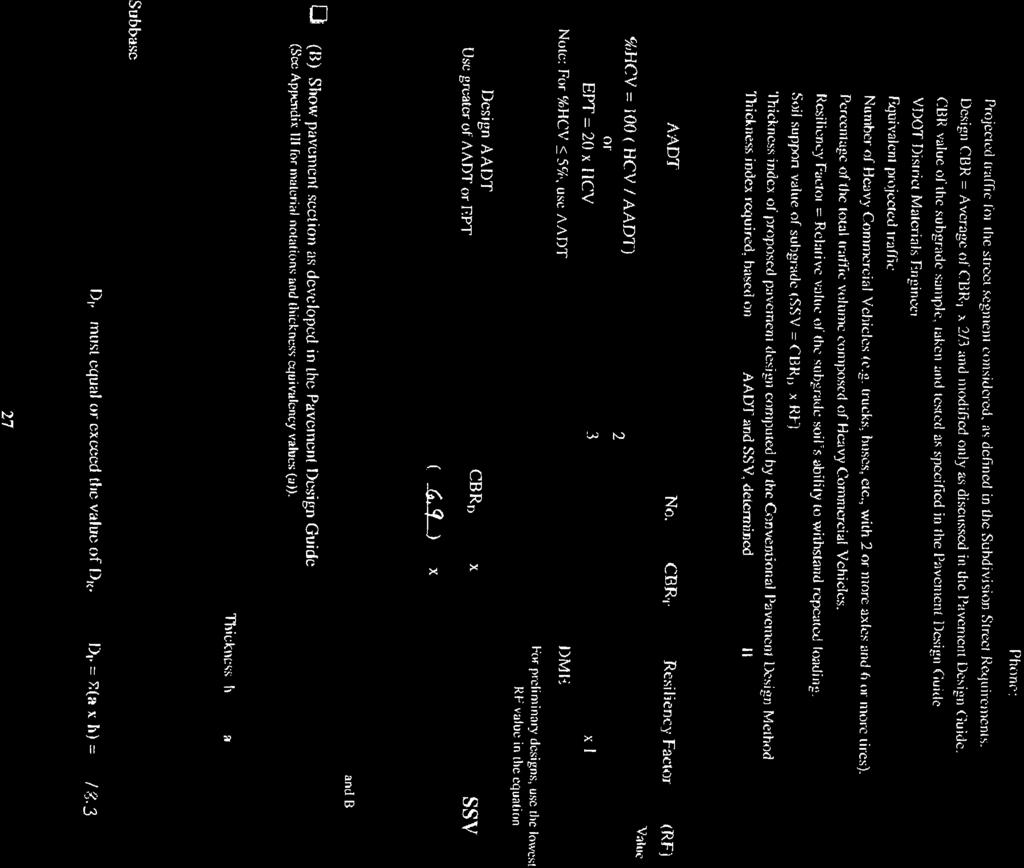
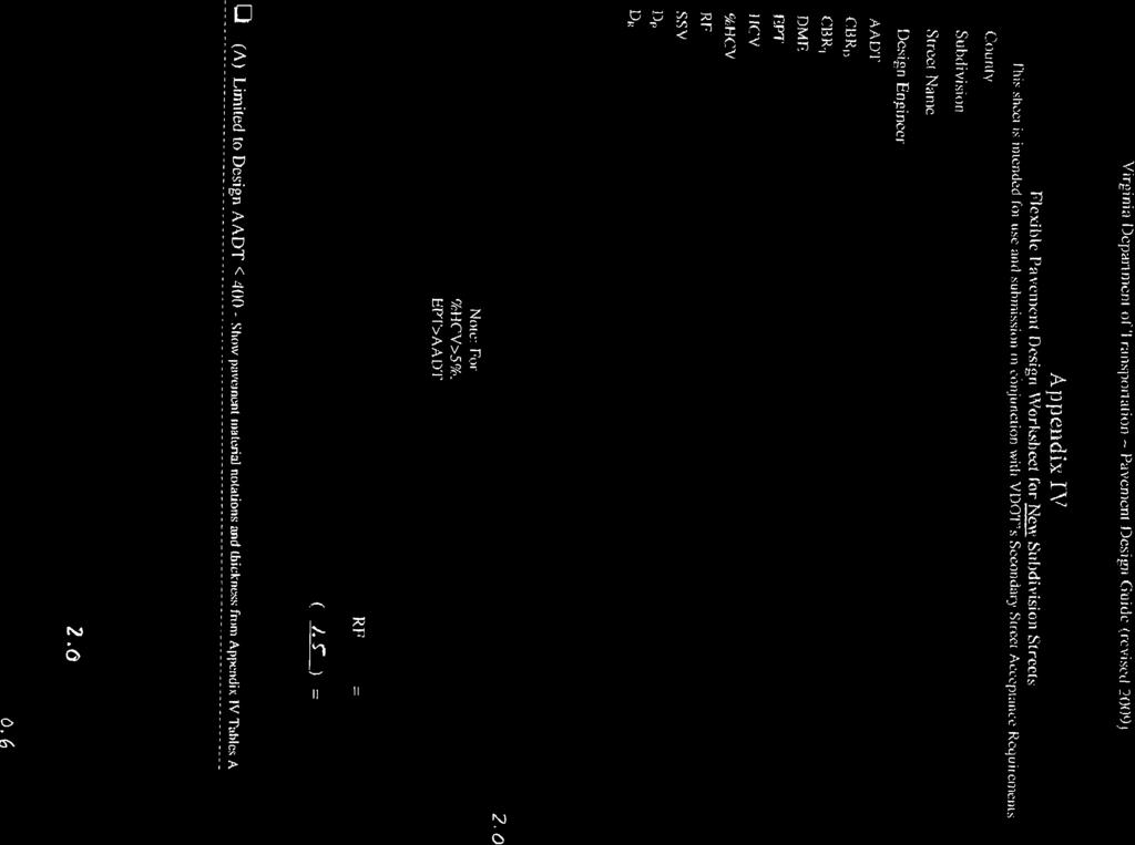
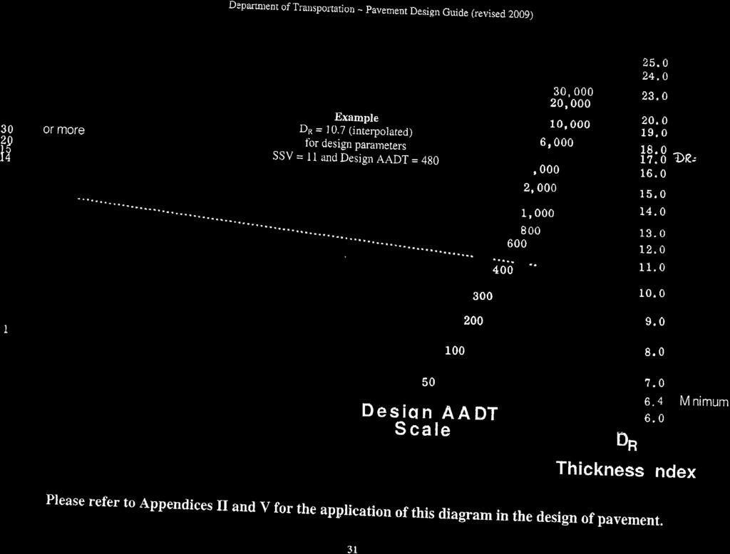
11 Geotechnical Engineering Report Project No Project Minecraft Access Road Dinwiddie County, VA February 20, Pavement Support Because the entrance road is a secondary road with a relatively low annual daily traffic (ADT) of 1,250 vehicles (15% trucks), the pavement analyses for this road was conducted using the VDOT 2014 Pavement Design Guide for Subdivision and Secondary Roads in Virginia. A design California Bearing Ratio (CBR) value of 6.9 percent was used (two-thirds of the average measured CBR values stated in this report). Pavement analyses are provided in Appendix E. According to our pavement analysis, the minimum required pavement sections for the new access road is approximately 6 inches of asphalt over 8 inches of base. We have assumed the turn lanes off of Boydton Plank Road (Route 1) will have the same traffic load conditions, and the required asphalt pavement thickness for the access road is approximately the same thickness existing asphalt pavement along Boydton Plank Road. Therefore, we recommend the new access road and turn lane taper have the same pavement section thickness, as shown in the following table. Recommended Pavement Section Minecraft Access Road and New Turn Lanes 2 Inches VDOT SM-12.5A (Placed in single lift) 4 Inches VDOT BM-25.0A (Placed in single lift) 8 Inches VDOT 21B All materials and construction methods should conform to the latest edition of the VDOT Road and Bridge Specifications. To confirm that the base course stone has been uniformly compacted and meets VDOT density requirements, in-place density tests should be performed by a qualified soils technician and the area should be thoroughly proofrolled under his observation. Important factors regarding pavement performance are the condition of subgrade soils at time of construction and post construction drainage. We recommend that all pavement subgrade areas be evaluated prior to base course stone placement. Any areas which deflect or rut during proofrolling must be repaired prior to stone placement. Sufficient testing and observation should be performed during pavement construction to confirm that the required thickness, density, and quality requirements of the specifications are followed. 8

12
13 APPENDIX A FIGURES

14 NORTH APPROXIMATE SITE LOCATION Source: Google Maps SCALE: NTS CHECKED BY: JNR PLOTTED BY: DATE: JMR PROJECT NUMBER: SITE VICINITY MAP PROJECT MINECRAFT ACCESS ROAD BOYDTON PLANK ROAD DINWIDDIE COUNTY, VA FIGURE 1
15 K:\Geotechnical\PROJECTS\2016 Projects\---COMPLETED PROJECTS FOLDER ---\ Minecraft Entrance Road\Drafting\Boring Location Plan.dwg Plotted on 2/20/2017 2:42 PM by Julian Ruffin C C HA C BOYDTON PLANK ROAD HA-01 HA HA B HA B HA NAD 83 SCALE 1"=150' ' 300' APPROXIMATE LOCATION OF PREVIOUS TEST BORING APPROXIMATE LOCATION OF HAND AUGER BORING B APPROXIMATE LOCATION OF ASPHALT CORE 188 YOUR VISION ACHIEVED THROUGH OURS. THIS DRAWING PREPARED AT THE Corporate Headquarters 1001 Boulders Parkway Richmond, VA TEL FAX SHEET NO JOB NO. PROJECT MINECRAFT ACCESS ROAD DINWIDDIE COUNTY - VIRGINIA LOCATION PLAN These plans and associated documents are the exclusive property of TIMMONS GROUP and may not be reproduced in whole or in part and shall not be used for any purpose whatsoever, inclusive, but not limited to construction, bidding, and/or construction staking without the express written consent of TIMMONS GROUP. AS SHOWN SCALE N. REEVES CHECKED BY N. REEVES DESIGNED BY J. RUFFIN DRAWN BY 10/11/2016 DATE DATE... REVISION DESCRIPTION
16 APPENDIX B BORING LOGS
17 Project: PROJECT MINECRAFT ACCESS ROAD Project No: Performed By: J. Ruffin Date Boring 10/27/2016 HA-01 10/27/2016 HA-02 10/27/2016 HA-03 Depth (Feet) HAND AUGER BORING LOG Description Depth (Feet) Average 0 Topsoil (6 Inches) (Groundwater at 4 feet) Sandy Silt (ML), moist, medium stiff, gray, contains roots Sandy Lean Clay (CL), wet, soft, light brownish gray Change: very soft Change: soft, light orangeish brown and gray Change: medium stiff Hand Auger Terminated 5 0 Topsoil (3 Inches) (Groundwater at 4 feet) Fill-Silty Sand (SM), fine to medium grained, moist, loose, 0.25 gray 1 Sandy Fat Clay (CH), moist, soft, light brownish gray Sandy Lean Clay (CL), moist, medium stiff, light orangeish brown 3 Change: stiff, light orangeish brown and gray Sandy Fat Clay (CH), wet, medium stiff, light orangeish brown and gray 5 Hand Auger Terminated 5 0 Topsoil (3 Inches) Sandy Silt (ML), moist, medium stiff, gray Sandy Fat Clay (CH), moist, soft, orangeish brown and gray Clayey Sand (SC), fine to medium, moist, medium dense, light orangeish brown and gray 3 Change: orangeish gray and gray Hand Auger Terminated 5 The dynamic cone penetrometer (DCP) test procedure is as follows: The cone point of the penetrometer is first seated 2 inches into the bearing materials to embed the point. Then the cone point is driven an additional 1-3/4 inches using a 15-pound weight falling 20 inches. The penetrometer reading is the number of blows required to drive the cone point 1-3/4 inches. DCP Values
 Description Depth (Feet) DCP Values 1 2 3 Average 0 Topsoil (4 Inches) (Groundwater at 4 feet)")
18 Project: PROJECT MINECRAFT ACCESS ROAD Project No: Performed By: J. Ruffin HAND AUGER BORING LOG Date Boring 10/27/2016 HA-04 10/27/2016 HA-05 10/27/2016 HA-06 Depth (Feet) Description Depth (Feet) DCP Values Average 0 Topsoil (4 Inches) (Groundwater at 4 feet) Sandy Silt (ML), moist, medium stiff, gray Sandy Fat Clay (CH), moist, soft, orangeish brown and gray Clayey Sand (SC), fine to medium grained, moist, loose, orangeish brown Sandy Fat Clay (CH), wet, stiff, orangeish brown and gray Hand Auger Terminated 5 0 Topsoil (5 Inches) Sandy Lean Clay (CL), moist, soft, gray Sandy Silt (ML), moist, soft, light orangeish brown and gray Change: stiff Hand Auger Terminated 5 0 Topsoil (3 Inches) Lean Clay with Sand (CL), moist, medium stiff, light gray, 0.25 contains roots 1 Change: soft, light brown and gray Change: Sandy Lean Clay (CL), medium stiff, light orangeish brown and gray Change: stiff Hand Auger Terminated 5 The dynamic cone penetrometer (DCP) test procedure is as follows: The cone point of the penetrometer is first seated 2 inches into the bearing materials to embed the point. Then the cone point is driven an additional 1-3/4 inches using a 15-pound weight falling 20 inches. The penetrometer reading is the number of blows required to drive the cone point 1-3/4 inches.
19 TG GEOTECH BH LOG V2.0 - GINT STD US LAB.GDT - 15/6/16 10:11 - K:\GEOTECHNICAL\PROJECTS\2016 PROJECTS\38390 PROJECT MINECRAFT - FINAL GEOTECH PHASE\FINANCIAL\37316 PATTON MINECRAFT\LOGS\PATTON MINECRAFT.GPJ PROJECT NUMBER CLIENT DRILLING CONTRACTOR LOGGED BY NOTES DEPTH (ft) ELEVATION (ft) AM King Construction Julian Ruffin TOPSOIL: (4 Inches) SANDY FAT CLAY, (CH): grayish brown, moist (CH): medium stiff Landmark Drilling, Inc. DRILLING METHOD Hollow Stem Auger MATERIAL DESCRIPTION CLAYEY SAND, (SC): gray, fine to medium grained, moist, medium dense SANDY FAT CLAY, (CH): orangeish brown and gray, moist, very stiff (CH): brown and gray, stiff Timmons Group 1001 Boulders Parkway, suite DATE STARTED 9/10/2015 COMPLETED 9/10/2015 CHECKED BY Bottom of borehole at 10.0 feet. SYMBOL PROJECT NAME PROJECT LOCATION GROUND ELEVATION SAMPLING BLOW COUNTS (N-VALUE) S-1, SPT (4) S-2, SPT (8) S-3, SPT (19) S-4, SPT (27) S-5, SPT (11) POCKET PEN. (tsf) 186 ft BOREHOLE WATER LEVELS: AT END OF DRILLING Project Minecraft Patton AT 24 HOURS DRILLING --- Dinwiddie County, Virginia LAB TESTS HOLE DEPTH --- not encountered BORING B-01 PAGE 1 OF 1 CAVE DEPTH 10 feet REMARKS
20 TG GEOTECH BH LOG V2.0 - GINT STD US LAB.GDT - 15/6/16 10:11 - K:\GEOTECHNICAL\PROJECTS\2016 PROJECTS\38390 PROJECT MINECRAFT - FINAL GEOTECH PHASE\FINANCIAL\37316 PATTON MINECRAFT\LOGS\PATTON MINECRAFT.GPJ PROJECT NUMBER CLIENT DRILLING CONTRACTOR LOGGED BY NOTES DEPTH (ft) ELEVATION (ft) AM King Construction Julian Ruffin Landmark Drilling, Inc. DRILLING METHOD Hollow Stem Auger Timmons Group 1001 Boulders Parkway, suite DATE STARTED 9/10/2015 COMPLETED 9/10/2015 CHECKED BY MATERIAL DESCRIPTION TOPSOIL: (4 Inches) SANDY LEAN CLAY, (CL): brown, moist, medium stiff CLAYEY SAND, (SC): brown and gray, fine to medium grained, moist, loose SILTY SAND, (SM): reddish brown, fine to medium grained, moist, medium dense SANDY FAT CLAY, (CH): orangeish brown and gray, moist, stiff Bottom of borehole at 10.0 feet. SYMBOL PROJECT NAME PROJECT LOCATION GROUND ELEVATION SAMPLING BLOW COUNTS (N-VALUE) S-1, SPT (6) S-2, SPT (8) S-3, SPT (19) S-4, SPT (12) S-5, SPT (15) POCKET PEN. (tsf) 186 ft BOREHOLE WATER LEVELS: AT END OF DRILLING Project Minecraft Patton AT 24 HOURS DRILLING --- Dinwiddie County, Virginia LAB TESTS HOLE DEPTH --- not encountered BORING B-02 PAGE 1 OF 1 CAVE DEPTH 10 feet REMARKS

21 TG GEOTECH BH LOG V2.0 - GINT STD US LAB.GDT - 15/6/16 10:11 - K:\GEOTECHNICAL\PROJECTS\2016 PROJECTS\38390 PROJECT MINECRAFT - FINAL GEOTECH PHASE\FINANCIAL\37316 PATTON MINECRAFT\LOGS\PATTON MINECRAFT.GPJ PROJECT NUMBER CLIENT DRILLING CONTRACTOR LOGGED BY NOTES DEPTH (ft) ELEVATION (ft) AM King Construction Julian Ruffin TOPSOIL: (4 Inches) SANDY SILT, (ML): grayish brown, moist, medium stiff SANDY LEAN CLAY, (CL): brown and gray, moist (CL): stiff CLAYEY SAND, (SC): gray, fine to medium grained, moist, medium dense Brown and gray Landmark Drilling, Inc. DRILLING METHOD Hollow Stem Auger Timmons Group 1001 Boulders Parkway, suite DATE STARTED 9/10/2015 COMPLETED 9/10/2015 CHECKED BY MATERIAL DESCRIPTION Bottom of borehole at 10.0 feet. SYMBOL PROJECT NAME PROJECT LOCATION GROUND ELEVATION SAMPLING BLOW COUNTS (N-VALUE) S-1, SPT (7) S-2, SPT (18) S-3, SPT (12) S-4, SPT (23) S-5, SPT (11) POCKET PEN. (tsf) 187 ft BOREHOLE WATER LEVELS: AT END OF DRILLING Project Minecraft Patton AT 24 HOURS DRILLING --- Dinwiddie County, Virginia LAB TESTS HOLE DEPTH --- not encountered BORING B-03 PAGE 1 OF 1 CAVE DEPTH 10 feet REMARKS
22 APPENDIX C LABORATORY TEST RESULTS
23 GRAIN SIZE DISTRIBUTION TEST REPORT Project Number Project Name Location Minecraft Entrance Road HA-05 Bulk/ 0-5 Liquid Limit Plastic Index USCS AASHTO 33 8 ML A-4 (0.0) Percent Gravel Percent Sand Percent Silt and Clay 0.0% 34.0% 66.0% Material Description Sandy SILT Natural Moisture 18.8% SPT Blow Counts N/A Grain Size Distribution 100 #4 #10 #40 # Percent Finer Grain Size - mm DATE 12/13/16 FIGURE NUMBER GS4
24 PROCTOR TEST REPORT Project Number Project Name Minecraft Entrance Road Location HA-05 Bulk/ 0-5 Maximum Dry Density, pcf Optimum Moisture Material Description Sandy SILT Uncorrected Rock Corrected Results USCS Natural Moisture Liquid Limit ML AASHTO A-4 (0.0) 18.8% Percent Fines 66.0% 33 Plastic Index 8 Moisture-Density Curve Dry Density, pcf % 5.0% 10.0% 15.0% 20.0% 25.0% 30.0% Water Content DATE 12/13/16 FIGURE NUMBER PR2
25 CBR TEST REPORT Project Number Project Name Minecraft Entrance Road Location HA-05 Bulk/ 0-5 *NOTE: 10 lbs. surcharge weights in place during soak and loading CBR at.1" CBR at.2 " Swell % Dry Density Moisture Compaction Molded % 100.1% Soaked % 98.8% Material Description Sandy SILT USCS Natural Moisture Liquid Limit Maximum Dry Density ML 18.8% AASHTO Percent Fines Plastic Index Optimum Moisture A-4 (0.0) 66.0% % 1.8% % Penetration Resistance, psi Swell 1.4% 1.2% 1.0% 0.8% 0.6% % 0.2% Penetration, Inches 0.0% Time, hours DATE 12/13/16 FIGURE NUMBER CBR 1
26 GRAIN SIZE DISTRIBUTION TEST REPORT Project Number Project Name Location Minecraft Entrance Road HA-04 Bulk/ 0-5 Liquid Limit Plastic Index USCS AASHTO SC A-6 (3.3) Percent Gravel Percent Sand Percent Silt and Clay 0.0% 52.5% 47.5% Material Description Clayey SAND Natural Moisture 20.3% SPT Blow Counts N/A Grain Size Distribution 100 #4 #10 #40 # Percent Finer Grain Size - mm DATE 12/13/16 FIGURE NUMBER GS4
27 PROCTOR TEST REPORT Project Number Project Name Minecraft Entrance Road Location HA-04 Bulk/ 0-5 Maximum Dry Density, pcf Optimum Moisture Material Description Clayey SAND Uncorrected Rock Corrected Results USCS Natural Moisture Liquid Limit SC AASHTO A-6 (3.3) 20.3% Percent Fines 47.5% 39 Plastic Index 20 Moisture-Density Curve Dry Density, pcf % 5.0% 10.0% 15.0% 20.0% 25.0% 30.0% Water Content DATE 12/13/16 FIGURE NUMBER PR2
28 CBR TEST REPORT Project Number Project Name Minecraft Entrance Road Location HA-04 Bulk/ 0-5 *NOTE: 10 lbs. surcharge weights in place during soak and loading CBR at.1" CBR at.2 " Swell % Dry Density Moisture Compaction Molded % 101.6% Soaked % 100.9% Material Description Clayey SAND USCS Natural Moisture Liquid Limit Maximum Dry Density SC 20.3% AASHTO Percent Fines Plastic Index Optimum Moisture A-6 (3.3) 47.5% % % 1.6% Penetration Resistance, psi Swell 1.4% 1.2% 1.0% 0.8% 0.6% % 0.2% Penetration, Inches 0.0% Time, hours DATE 12/13/16 FIGURE NUMBER CBR 1
29 GRAIN SIZE DISTRIBUTION TEST REPORT Project Number Project Name Location Minecraft Entrance Road HA-01 Bulk/ 0-5 Liquid Limit Plastic Index USCS AASHTO CL A-6 (2.3) Percent Gravel Percent Sand Percent Silt and Clay 0.0% 38.0% 62.0% Material Description Sandy Lean CLAY Natural Moisture 17.1% SPT Blow Counts N/A Grain Size Distribution 100 #4 #10 #40 # Percent Finer Grain Size - mm DATE 12/13/16 FIGURE NUMBER GS4
30 PROCTOR TEST REPORT Project Number Project Name Minecraft Entrance Road Location HA-01 Bulk/ 0-5 Maximum Dry Density, pcf Optimum Moisture Material Description Uncorrected Sandy Lean CLAY Rock Corrected Results USCS Natural Moisture Liquid Limit CL AASHTO A-6 (2.3) 17.1% Percent Fines 62.0% 30 Plastic Index 15 Moisture-Density Curve Dry Density, pcf % 5.0% 10.0% 15.0% 20.0% 25.0% 30.0% Water Content DATE 12/13/16 FIGURE NUMBER PR2
31 CBR TEST REPORT Project Number Project Name Minecraft Entrance Road Location HA-01 Bulk/ 0-5 *NOTE:10 lbs. surcharge weights in place during soak and loading CBR at.1" CBR at.2 " Swell % Dry Density Moisture Compaction Molded % 100.9% Soaked % 99.2% Material Description Sandy Lean CLAY USCS Natural Moisture Liquid Limit Maximum Dry Density CL 17.1% AASHTO Percent Fines Plastic Index Optimum Moisture A-6 (2.3) 62.0% % % 1.6% Penetration Resistance, psi Swell 1.4% 1.2% 1.0% 0.8% 0.6% % 0.2% Penetration, Inches 0.0% Time, hours DATE 12/13/16 FIGURE NUMBER CBR 1
32 GRAIN SIZE DISTRIBUTION TEST REPORT Project Number Project Name Location Minecraft Entrance Road HA-02/ 1-2 Liquid Limit Plastic Index USCS AASHTO CL A-4 (0.0) Percent Gravel Percent Sand Percent Silt and Clay 0.0% 44.7% 55.3% Material Description Sandy Lean CLAY Natural Moisture 13.0% SPT Blow Counts Grain Size Distribution 100 #4 #10 #40 # Percent Finer Grain Size - mm DATE 12/13/16 FIGURE NUMBER GS4
33 GRAIN SIZE DISTRIBUTION TEST REPORT Project Number Project Name Location Minecraft Entrance Road HA-03/ 2-3 Liquid Limit Plastic Index USCS AASHTO SC A-6 (0.4) Percent Gravel Percent Sand Percent Silt and Clay 0.0% 63.0% 37.0% Material Description Clayey SAND Natural Moisture 18.7% SPT Blow Counts Grain Size Distribution 100 #4 #10 #40 # Percent Finer Grain Size - mm DATE 12/13/16 FIGURE NUMBER GS4
34 GRAIN SIZE DISTRIBUTION TEST REPORT Project Number Project Name Location Minecraft Entrance Road HA-06/ 0-1 Liquid Limit Plastic Index USCS AASHTO 24 9 CL A-4 (0.0) Percent Gravel Percent Sand Percent Silt and Clay 0.0% 28.5% 71.5% Material Description Lean CLAY with Sand Natural Moisture 16.4% SPT Blow Counts Grain Size Distribution 100 #4 #10 #40 # Percent Finer Grain Size - mm DATE 12/13/16 FIGURE NUMBER GS4
35 APPENDIX D ASPHALT CORE PHOTOS


36 C INCHES ASPHALT 2.0 INCHES CEMENT TREATED BASE* *CORE BARREL REFUSAL IN CEMENT TREATED BASE C INCHES ASPHALT CORE BARREL REFUSAL IN CEMENT TREATED BASE SCALE: NTS CHECKED BY: JNR PLOTTED BY: JMR DATE: PROJECT NUMBER: ASPHALT CORE LOG PROJECT MINECRAFT ACCESS ROAD BOYDTON PLANK ROAD DINWIDDIE COUNTY, VA FIGURE 1


37 C INCHES ASPHALT SCALE: NTS CHECKED BY: JNR PLOTTED BY: DATE: JMR PROJECT NUMBER: ASPHALT CORE LOG PROJECT MINECRAFT ACCESS ROAD BOYDTON PLANK ROAD DINWIDDIE COUNTY, VA FIGURE 2
38 APPENDIX E PAVEMENT CALCULATIONS
39
40
April 7, Webster Street Sub-Surface Stormwater Storage System Bid No Bid Date: 4/13/17 ADDENDUM NO 1
 PUBLIC WORKS DEPARTMENT David A. Jones, P.E., Director April 7, 2017 Webster Street Sub-Surface Stormwater Storage System Bid No. 2017-022 Bid Date: 4/13/17 ADDENDUM NO 1 Please make the following changes
Geotechnical Engineering Report
 Geotechnical Engineering Report Pavement Subgrade Survey State Highway 125 over Hudson Creek Ottawa County, Oklahoma September 23, 21 Terracon Project No. 415121 Prepared for: Guy Engineering Services,
Subsurface Investigation Report. Proposed New 1-Story Building 6447 Grand Avenue Gurnee, Illinois
 AGI Project No. -11 Subsurface Investigation Report For the Proposed New 1-Story Building 6447 Grand Avenue Gurnee, Illinois Prepared for Mr. Steve Panko Key Development Partners, LLC North State Street,
Applied GeoScience, Inc Hammond Dr., Suite 6 Schaumburg, Illinois
 AGI Project No. 13-276 Subsurface Investigation Report For the Proposed New Retail Center 9601 South Pulaski Road Evergreen Park, Illinois Prepared for Mr. Feras Sweis FHS Design + Build LLC 2010 West
Geotechnical Engineering Report
 Geotechnical Engineering Report Shaw AFB East Gate Entrance Control Facility Amendment Sumter, South Carolina September 13, 2010 Terracon Project No. 73105020A Prepared for: TranSystems North Charleston,
Applied GeoScience, Inc Hammond Dr., Suite 6 Schaumburg, Illinois
 AGI Project No. 13-109B Subsurface Investigation Report For the Proposed Roosevelt Middle School Site Improvements 7560 Oak Avenue River Forest, Illinois Prepared for Mr. Jerry Pilipowicz Terra Engineering,
SUBSURFACE EXPLORATION & GEOTECHNICAL ENGINEERING EVALUATION
 Report of Subsurface Exploration and Geotechnical Engineering Evaluation Proposed Courtyard Marriott Phenix City, Alabama BHATE Project Number: 112263 October 9, 2012 SUBSURFACE EXPLORATION & GEOTECHNICAL
GEOTECHNICAL INVESTIGATION I-15 SIGN BRIDGES LAS VEGAS EA JANUARY
 GEOTECHNICAL INVESTIGATION I-15 SIGN BRIDGES LAS VEGAS EA 73171 JANUARY 06 MATERIALS DIVISION STATE OF NEVADA DEPARTMENT OF TRANSPORTATION MATERIALS DIVISION GEOTECHNICAL SECTION GEOTECHNICAL REPORT I-15
Geotechnical Engineering Report
 Geotechnical Engineering Report Turner Turnpike Widening Milepost 210 to 218 Drainage Structure Pipe Jacking Creek County, Oklahoma July 1, 2016 Terracon Project No. 04165017 Prepared for: Benham Tulsa,
REPORT OF SUBSURFACE EXPLORATION
 REPORT OF SUBSURFACE EXPLORATION WELDING & JOINING TECHNOLOGY FACILITY NORTH GEORGIA TECHNICAL COLLEGE CLARKESVILLE, GEORGIA S&ME PROJECT NO. 161-10-061 Prepared For: LW Engineering, P.C. Post Office Box
CHAPTER 7 PAVEMENT DESIGN. 1. Gradation (sieve and hydrometer analysis) 3. Moisture density relationships and curves
 3. Moisture density relationships and curves") CHAPTER 7 PAVEMENT DESIGN 7.0 GENERAL The purpose of this chapter is to define the requirements for design of pavement within proposed and existing roadways for new subdivision streets and secondary roads.
CHAPTER 7 PAVEMENT DESIGN 7.0 GENERAL The purpose of this chapter is to define the requirements for design of pavement within proposed and existing roadways for new subdivision streets and secondary roads.
Please include this addendum in your Bid proposal for the above referenced project. Questions are in black ink, and the answers are in red ink.
 JAHarchitects, LLC PROJECT NO. 393 RIVERCREST CDD 11560 RAMBLE CREEK DRIVE, RIVERVIEW FL ADDENDUM TO BID PROJECT: RIVERCREST CDD MULTI PURPOSE FIELD MAINTENANCE BUILDING & DOG PARK POOL & CABANNA JAH PROJECT
Typical Subsurface Profile. November 28, 2016
 November 28, 2016 RSCCD Facility Planning, District Construction and Support Services 2323 N. Broadway, Suite 112, Santa Ana, CA 92706 Attn: Re: Ms. Allison Coburn Facilities Project Manager P: (714) 480-7530
Geotechnical Testing Laboratory, Inc. Engineering and Construction Materials Testing Services
 Engineering and Construction Materials Testing Services February 27, 15 Central Louisiana Economic and Development Alliance P.O. Box 465 Alexandria, Louisiana 719 Attention: Mr. Rick Ranson Vice President
REPORT OF SUBSURFACE INVESTIGATION AND GEOTECHNICAL ENGINEERING SERVICES
 REPORT OF SUBSURFACE INVESTIGATION AND GEOTECHNICAL ENGINEERING SERVICES Elizabeth City, North Carolina G E T Project No: EC14-188G May 30, 2014 PREPARED FOR: 106 Capital Trace, Unit E Elizabeth City,
Washtenaw Community College Design & Construction Facilities Management 4800 East Huron River Drive Ann Arbor, MI
 Washtenaw Community College Design & Construction Facilities Management 4800 East Huron River Drive Ann Arbor, MI 4810-4800 GEOTECHNICAL INVESTIGATION FOR Proposed Pavement Rehabilitation Parking Lots
August 15, 2006 (Revised) July 3, 2006 Project No A
 July 3, 2006 Project No A") August 15, 2006 (Revised) July 3, 2006 Project No. 01-05-0854-101A Mr. David Reed, P.E. Protean Design Group 100 East Pine Street, Suite 306 Orlando, Florida 32801 Preliminary Soil Survey Report Polk Parkway
August 15, 2006 (Revised) July 3, 2006 Project No. 01-05-0854-101A Mr. David Reed, P.E. Protean Design Group 100 East Pine Street, Suite 306 Orlando, Florida 32801 Preliminary Soil Survey Report Polk Parkway
Subsurface Investigation Report
 AGI Project No. 17-154 Subsurface Investigation Report For the Proposed New One-Story Building Addition 7030 West 111 th Street Worth, Illinois Prepared for T63 Development LLC 11052 Mayflow er Lane Orland
Preliminary Geotechnical Exploration Armstrong Tract Rivers Avenue and Hanahan Road North Charleston, South Carolina S&ME Project No.
 Preliminary Geotechnical Exploration Rivers Avenue and Hanahan Road S&ME Project No. 4213-16-016 Prepared for: Charleston Water System 103 Saint Phillip Street Charleston, South Carolina 29403 Prepared
REPORT OF SUBSURFACE EXPLORATION AND GEOTECHNICAL ENGINEERING SERVICES
 REPORT OF SUBSURFACE EXPLORATION AND GEOTECHNICAL ENGINEERING SERVICES NORTH SHORE SCHOOL DISTRICT 11 HIGHLAND PARK, ILLINOIS ECS PROJECT NO. 1:8 FOR NORTH SHORE SCHOOL DISTRICT 11 SEPTEMBER, 1 REPORT
REPORT OF SUBSURFACE EXPLORATION AND GEOTECHNICAL ENGINEERING ANALYSIS
 REPORT OF SUBSURFACE EXPLORATION AND GEOTECHNICAL ENGINEERING ANALYSIS HADENSVILLE FIRE STATION # THREE CHOPT ROAD AND OLD FREDERICKSBURG ROAD GOOCHLAND COUNTY, VIRGINIA FOR Mr. Josh Bennett Moseley Architects,
Subsurface Environmental Investigation
 Subsurface Environmental Investigation Lake Development East Lake and 21 st Avenue South February 23, 201 Terracon Project No. MP14738A Prepared for: Minneapolis Public Schools Prepared by: Terracon Consultants,
GENERAL SOILS EVALUATION REPORT. For
 GENERAL SOILS EVALUATION REPORT For EL PASO WATER UTILITIES (EPWU) PROPOSED AUSTIN STORMWATER POND IMPROVEMENTS NE OF ALTURA AVE. & LACKLAND ST. EL PASO, EL PASO COUNTY, TEXAS Prepared For MORENO CARDENAS
A. Texas Department Transportation 2004 Standard Specifications for Construction of Highways, Streets and Bridges (TxDOT):
:") SECTION 31 32 13.16 CEMENT STABILIZATION PART 1 GENERAL 1.1 SCOPE OF WORK A. This Section pertains to the specifications for cement stabilization of sandy or silty soil and consists of pulverizing, addition
SECTION 31 32 13.16 CEMENT STABILIZATION PART 1 GENERAL 1.1 SCOPE OF WORK A. This Section pertains to the specifications for cement stabilization of sandy or silty soil and consists of pulverizing, addition
GEOTECHNICAL REPORT B-1942
 GEOTECHNICAL REPORT TUSCARORA BRIDGE REPLACEMENT B-1942 E.A. 73561 March 2011 MATERIALS DIVISION STATE OF NEVADA DEPARTMENT OF TRANSPORTATION MATERIALS DIVISION GEOTECHNICAL SECTION GEOTECHNICAL REPORT
SUBSURFACE INVESTIGATION, LABORATORY TESTING PROGRAM, AND PAVEMENT RECOMMENDATIONS
 February 7, 2017 EDR Architects, PLLC PO Box 271613 Corpus Christi, TX 78427 Attention: Ms. Emily D. Rozypal, AIA SUBJECT: SUBSURFACE INVESTIGATION, LABORATORY TESTING PROGRAM, AND PAVEMENT RECOMMENDATIONS
geotechnical and construction materials consultants
 geotechnical and construction materials consultants City of Dallas Public Works and Transportation Department 320 E. Jefferson Blvd, Room 307 Dallas, Texas 75203 ATTN: Mr. Vincent Lewis, P.E. Email: Vincent.lewis@dallascityhall.com
GEOTECHNICAL STUDY HIDDEN VALLEY SPORTS PARK RESTROOM FACILITY MABEL JONES DRIVE CANYON LAKE, TEXAS
 FUGRO CONSULTANTS, INC. GEOTECHNICAL STUDY HIDDEN VALLEY SPORTS PARK RESTROOM FACILITY MABEL JONES DRIVE CANYON LAKE, TEXAS COMAL COUNTY Canyon Lake, Texas GEOTECHNICAL STUDY HIDDEN VALLEY SPORTS PARK
GEOTECHNICAL EXPLORATION REPORT. For the. Project ID: th Avenue Vogt Drive to Decorah Road Local Street Washington County.
 GEOTECHNICAL EXPLORATION REPORT For the Project ID: 277--9 18 th Avenue Vogt Drive to Decorah Road Local Street Washington County Prepared for: Alfred Benesch & Company 1 West Canal Street, Suite 15 Milwaukee,
SECTION TRENCHING & BACKFILLING
 SECTION 02225 - TRENCHING & BACKFILLING 1.0 GENERAL 1.1 Work included in this Section includes trenching and backfilling for underground pipelines and related structures only. 1.2 Reference Specifications
ECS PROJECT NO. 04:9974. For. Community Housing Partners c/o Mr. Lee S. Alford 4915 Radford Avenue, Suite 300 Richmond, Virginia 23230
 PRELIMINARY REPORT OF SUBSURFACE EXPLORATION AND GEOTECHNICAL ENGINEERING ANALYSIS TRANQUILITY AT THE LAKES 82 BURTON STATION ROAD VIRGINIA BEACH, VIRGINIA ECS PROJECT NO. 0:99 For Community Housing Partners
This report presents the findings of the subsurface exploration concerning the design of the taxiway rehabilitation. Description
 September 22, 2016 American Infrastructure Development, Inc. 3810 Northdale Boulevard, Suite 170 Tampa, Florida 33624 Attn: Mr. Mohsen Mohammadi, Ph.D., P.E. Senior Consultant Mob: (813) 244-6609 E-mail:
File No Supplemental November Geotechnical and Environmental Consulting Engineers
 Supplemental Information & Geotechnical Recommendations Proposed New Solar Valley Location B (East of Building No. 7) Cañada Community College 4200 Farm Hill Boulevard Submitted to: Mr. Peter Hempel Construction
SUBSURFACE EXPLORATION, LABORATORY TESTING PROGRAM, AND FOUNDATION AND PAVEMENT RECOMMENDATIONS
 GEOTECHNICAL ENGINEERING CONSTRUCTION MATERIALS ENGINEERING & TESTING SOILS ASPHALT CONCRETE Elsasser Architectural Inc. P.O. Box 833 Georgetown, Texas 78627 Attention: Richard Elsasser relsasser@eai-tx.com
Geotechnical Investigation Report
 MC Squared, Inc. Geotechnical Investigation Report City of St. Petersburg Forcemain Pinellas County, Florida Prepared for: Hazen and Sawyer 10002. Princess Palm Ave., Suite 200 Tampa, Florida 33610 Prepared
GEOTEK ENGINEERING & TESTING SERVICES, INC. 909 East 50 th Street North Sioux Falls, South Dakota Phone Fax
 GEOTEK ENGINEERING & TESTING SERVICES, INC. 909 East 50 th Street North Sioux Falls, South Dakota 57104 Phone 605-335-5512 Fax 605-335-0773 October 28, 2016 City of Vermillion 25 Center Street 57069 Attn:
November 13, IP3406. Mr. Uriah Sowell Rooney Engineering 115 Inverness Drive East, Suite 300, Englewood, CO 80112
 November 13, 2015 103IP3406 Mr. Uriah Sowell Rooney Engineering 115 Inverness Drive East, Suite 300, Englewood, CO 80112 Subject: Infiltration Testing Gates Road Valve Site Sunoco Pennsylvania Pipeline
REPORT OF SUBSURFACE EXPLORATION AND GEOTECHNICAL ANALYSIS DMA TAMPA RED BRICK BUILDING TAMPA, FLORIDA FOR MRI ARCHITECTURAL GROUP, INC.
 REPORT OF SUBSURFACE EXPLORATION AND GEOTECHNICAL ANALYSIS DMA TAMPA RED BRICK BUILDING TAMPA, FLORIDA FOR MRI ARCHITECTURAL GROUP, INC. JANUARY 7, 2015 January 7, 2015 Mr. Pete Ikegami MRI Architectural
November 13, IP3406. Mr. Uriah Sowell Rooney Engineering 115 Inverness Drive East, Suite 300, Englewood, CO 80112
 November 13, 2015 103IP3406 Mr. Uriah Sowell Rooney Engineering 115 Inverness Drive East, Suite 300, Englewood, CO 80112 Subject: Infiltration Testing Hopeland Road Valve Site Sunoco Pennsylvania Pipeline
BASE CONSTRUCTION MATERIALS A Aggregate
 BASE CONSTRUCTION 2211 AGGREGATE BASE 2211.1 DESCRIPTION This work consists of placing aggregate base. 2211.2 MATERIALS A Aggregate... 3138 Provide the class of aggregate as required by the contract. 2211.3
CCR Rule Siting Criteria Unstable Areas
 CCR Rule Siting Criteria 257.64 Unstable Areas FGD Pond 5 Naughton Power Plant Kemmerer, Wyoming October 3, 217 PREPARED FOR PacifiCorp 147 West North Temple Salt Lake City, UT 84116 (81) 521-376 Fax (81)
CHAPTER 3 CONSTRUCTION AND TESTING OF SUBGRADE
 CHAPTER 3 CONSTRUCTION AND TESTING OF SUBGRADE WHAT IS SUBGRADE? SUBGRADE EMBANKMENT FOUNDATION The top surface of an embankment or cut section, shaped to conform to the typical section upon which the
Rock Creek Apartments Wheatland, WY
 Subsurface Exploration and Geotechnical Engineering Report Prepared for: Rock Creek Apartments, LLC C/O Blue Line Development 1004 South Ave West Missoula, MT 59801 Rock Creek Apartments Wheatland, WY
Thank you for choosing Professional Service Industries, Inc. (PSI) as your geotechnical consultant for the proposed project.
 as your geotechnical consultant for the proposed project.") Geotechnical July 7, 2014 Attn: Mr. Gregory A. Kidder Chief Procurement Officer WVNET 837 Chestnut Ridge Road Morgantown, West Virginia 26505 Reference: Preliminary Subsurface Investigation and Geotechnical
Geotechnical July 7, 2014 Attn: Mr. Gregory A. Kidder Chief Procurement Officer WVNET 837 Chestnut Ridge Road Morgantown, West Virginia 26505 Reference: Preliminary Subsurface Investigation and Geotechnical
GENERAL SOILS EVALUATION REPORT. For
 GENERAL SOILS EVALUATION REPORT For EPWU PROPOSED KENTUCKY DAM (DAM 5) DRAINAGE SYSTEM IMPROVEMENTS KENTUCKY ST. & ALABAMA ST. EL PASO, EL PASO COUNTY, TEXAS Prepared For MORENO CARDENAS INC. 2505 E. MISSOURI
In preparation for constructing buildings on a property, the builder. Site Preparation CHAPTER
 CHAPTER 3 Site Preparation In preparation for constructing buildings on a property, the builder must consider a number of factors related to code requirements. The buildings must be located according to
Consultant Specifications for Subsurface Investigation & Geotechnical Analysis and Design Recommendations
 Consultant Specifications for Subsurface Investigation & Geotechnical Analysis and Design Recommendations Mn/DOT Geotechnical Section - Office of Materials & Road Research http://www.mrr.dot.state.mn.us/geotechnical/foundations/tcontract.asp
PROJECT NO A. ISSUED: February 29, 2016
 INTERPRETIVE REPORT FOR INFILTRATION SYSTEM DESIGN, PROPOSED VILLA VERONA APARTMENT COMMUNITY, ASSESSOR S PARCEL NUMBERS 311-040-015, 311-040-021, 311-040-024, 311-040-026 AND 311-040-013, LOCATED ON THE
Report of Geotechnical Engineering Investigation OIA SOUTH CELL LOT (W340) AID Project No. GOA16001 Orange County, Florida GEC Project No.
 AID Project No. GOA16001 Orange County, Florida GEC Project No.") Report of Geotechnical Engineering Investigation OIA SOUTH CELL LOT (W40) AID Project No. GOA16001 Orange County, Florida GEC Project No. 956G July 6, 2017 American Infrastructure Development, Inc. 7 North
Report of Geotechnical Engineering Investigation OIA SOUTH CELL LOT (W40) AID Project No. GOA16001 Orange County, Florida GEC Project No. 956G July 6, 2017 American Infrastructure Development, Inc. 7 North
Stormwater Standards. Clackamas County Service District No. 1. Infiltration Testing Guide
 Stormwater Standards Clackamas County Service District No. 1 APPENDIX E Infiltration Testing Guide Table of Contents Appendix E - Infiltration Testing Guide... Page E.1 General... 1 E.2 Basic Method -
REPORT OF SUBSURFACE EXPLORATION AND GEOTECHNICAL ENGINEERING ANALYSIS BRUNSWICK FARM APARTMENTS MANOR TWP., LANCASTER CO.
 REPORT OF SUBSURFACE EXPLORATION AND GEOTECHNICAL ENGINEERING ANALYSIS BRUNSWICK FARM APARTMENTS MANOR TWP., LANCASTER CO., PENNSYLVANIA FOR ELA GROUP, INC. OCTOBER 22, 2013 October 22, 2013 Mrs. Cheryl
DIVISION 31 EARTHWORK 2006 Edition, Published January 1, 2006; Division Revision Date: January 31, 2012
 2006 Edition, Published January 1, 2006; Division Revision Date: January 31, 2012 PART FIVE DOCUMENTS FOR SITE AND INFRASTRUCTURE 31 00 00. EARTHWORK 31 10 00. SITE CLEARING.1 STRUCTURE REMOVAL: Include
Amendment 03 Soils Report. At Air Academy High School 6910 Carlton Drive Colorado Springs, CO 80840
 Amendment 03 Soils Report Issued: November 7, 2017 For RFP 18-KG-0928(BF) Design/Build Services for New Synthetic Turf Field At Air Academy High School 6910 Carlton Drive Colorado Springs, CO 80840 Academy
Addendum 1 - Appendix A - 1 of 22
 Addendum 1 - Appendix A - 1 of 22 Erdman Anthony of Florida, Inc. August 1, 2007 1402 Royal Palm Beach Boulevard Building 500 Royal Palm Beach, Florida 33411 Attention: Subject: Ms. Dana I. Gillette, P.E.,
SELECTIVE FLEXIBLE PAVEMENT REHABILITATION BASED ON FORENSIC INVESTIGATION AND DEFLECTION ANALYSIS: SEVENTEEN YEARS CASE STUDY IN VIRGINIA
 0 0 0 0 SELECTIVE FLEXIBLE PAVEMENT REHABILITATION BASED ON FORENSIC INVESTIGATION AND DEFLECTION ANALYSIS: SEVENTEEN YEARS CASE STUDY IN VIRGINIA Mohamed Elfino, Ph.D., P.E. * Assistant State Materials
REPORT OF SUBSURFACE EXPLORATION AND GEOTECHNICAL ENGINEERING EVALUATION. Panama City, Bay County, Florida
 REPORT OF SUBSURFACE EXPLORATION AND GEOTECHNICAL ENGINEERING EVALUATION PANAMA CITY MARINA LIGHTHOUSE Panama City, Bay County, Florida Prepared For: PANAMA CITY CRA 803 JENKS AVENUE,SUITE 1 PANAMA CITY,BAY
SPECIFICATIONS FOR PRECAST MODULAR BLOCK RETAINING WALL SYSTEM (revised 5/8/7)
") Page 1 of 7 STONE STRONG SYSTEMS SPECIFICATIONS FOR PRECAST MODULAR BLOCK RETAINING WALL SYSTEM (revised 5/8/7) PART 1: GENERAL 1.01 Description A. Work includes furnishing and installing precast modular
Page 1 of 7 STONE STRONG SYSTEMS SPECIFICATIONS FOR PRECAST MODULAR BLOCK RETAINING WALL SYSTEM (revised 5/8/7) PART 1: GENERAL 1.01 Description A. Work includes furnishing and installing precast modular
B. Backfill and compact utility bedding and fill placed in the utility trenches between the top of the utility bedding and the subgrade elevation.
 SECTION 312333 TRENCHING AND BACKFILLING PART 1 - GENERAL 1.1 SUMMARY A. Excavate trenches for new electric and telephone conduits, gas lines, and their appurtenances from at least 5 feet outside the building
B. Subsurface data is available from the Owner. Contractor is urged to carefully analyze the site conditions.
 SECTION 31 23 33 - TRENCHING, BACKFILLING AND COMPACTION PART 1 - GENERAL 1.1 SCOPE A. This Section specifies the requirements for excavating and backfilling for storm sewer, sanitary sewer, water distribution
GEOTECHNICAL ENGINEERING STUDY. For
 GEOTECHNICAL ENGINEERING STUDY For PROPOSED RESIDENCE INN BY MARRIOTT ALONG THE SOUTH SIDE OF SPUR 54 JUST NORTH OF THE EXISTING BASS PRO SHOPS HARLINGEN, CAMERON COUNTY, TEXAS Prepared for KRISHNA HARLINGEN
SOIL MECHANICS Assignment #2: Soil Classification Solution.
 Geotechnical Engineering Research Laboratory One University Avenue Lowell, Massachusetts 01854 Edward L. Hajduk, D.Eng, PE Lecturer PA105D Tel: (978) 934 2621 Fax: (978) 934 3052 e mail: Edward_Hajduk@uml.edu
Subsurface Exploration and Foundation Analysis Proposed New Weight Room / Fieldhouse Building 429 N Highway 83 Leakey, Texas
 Subsurface Exploration and Foundation Analysis Proposed New Weight Room / Fieldhouse Building 429 N Highway 83 Leakey, Texas InTEC Project No. S161639 April 18, 2016 Leakey ISD P.O. Box 1129 Leakey, Texas
TRENCH EXCAVATION AND BACKFILL
 SUDAS Standard Specifications Division 3 - Trench and Trenchless Construction Section 300 - Trench Excavation and Backfill TRENCH EXCAVATION AND BACKFILL PART - GENERAL.0 SECTION INCLUDES A. Trench Excavation
SOIL CLASSIFICATION BASICS Commonly based on grain size and soil consistency. Several classification systems exist:
 SOIL CLASSIFICATION BASICS Commonly based on grain size and soil consistency. Several classification systems exist: 1. Unified System (USCS) (ASTM D2487-11). 2. American Association of State Highway and
GEOTECHNICAL STUDY. Proposed East Point Fire Station No Ben Hill Road Drive East Point, Georgia
 GEOTECHNICAL STUDY AT Proposed East Point Fire Station No. 4 2222 Ben Hill Road Drive East Point, Georgia Submitted to Brown Design Group Mr. Coy Cooper, Jr. RA Brown Design Group 3099 Washington Road
BLEINC. August 17, Black & Veatch Corporation 201 Brookfield Parkway, Suite 150 Greenville, SC 29607
 BLEINC. BUNNELL-LAMMONS ENGINEERING, INC. GEOTECHNICAL, ENVIRONMENTAL AND CONSTRUCTION MATERIALS CONSULTANTS August 17, 2017 Black & Veatch Corporation 201 Brookfield Parkway, Suite 150 Greenville, SC
You also requested information regarding a sieve analysis at each boring locations. The test results are attached.
 FORENSICS CONSULTANTS ENVIRONMENTAL GEOTECHNICAL MATERIALS October 4, 2016 Washington County Public Works 11660 Myeron Road Stillwater, MN 55082 Attn: Mr. Marc Briese Re: Additional Borings CSAH 22 (70
REPORT OF SUBSURFACE EXPLORATION AND GEOTECHNICAL ENGINEERING SERVICES
 REPORT OF SUBSURFACE EXPLORATION AND GEOTECHNICAL ENGINEERING SERVICES Addendum No.1 5 th Bay Ocean View Norfolk, Virginia G E T Project No: VB15-342G November 18, 2016 PREPARED FOR: 204 Grayson Road Virginia
GEOTECHNICAL INVESTIGATION For PROPOSED OUTDOOR THEATER 495 Upper Park Road APN Santa Cruz, California
 GEOTECHNICAL INVESTIGATION For PROPOSED OUTDOOR THEATER 495 Upper Park Road APN 009-301-06 Santa Cruz, California Prepared For SANTA CRUZ SHAKESPEAR Santa Cruz, California Prepared By DEES & ASSOCIATES,
SECTION AGGREGATES
 SECTION 32 05 00 AGGREGATES PART 1 GENERAL 1.01 SUMMARY A. Section Includes: 1. Aggregate base 2. Engineered fill 3. Backfill 4. Fine filter aggregate (non-frost susceptible fill) 5. Riprap 6. Recreational
Geotechnical Engineering Report Proposed Household Hazardous Waste Facility Astoria, Oregon
 Proposed Household Hazardous Waste Facility Prepared for: Mr. Michael Summers, Director Clatsop County Public Works 1100 Olney Avenue 97103 Geotechnical Engineering Report Proposed Household Hazardous
APPENDIX D STORMWATER MANAGEMENT POND SIZING CALCULATIONS
 APPENDIX D STORMWATER MANAGEMENT POND SIZING CALCULATIONS PERMANENT POOL AND EXTENDED DETENTION SIZING 11097 Ontario Limited NW Paris Project Number: 1505 Date: September 2014 Designer: M.M.L.B. PERMANENT
The following sections provide the approved standard infiltration testing specifications.
 APPENDIX F.2 INFILTRATION TESTING To properly size and locate stormwater management facilities, it is necessary to characterize the soil infiltration conditions at the location of the proposed facility.
1. ADD the attached test hole reports for Well Nos. 19 & 20 to the specifications.
 1700 East Iron Ave. Salina, KS 67401 785-827-0433 phone 785-827-5949 fax Arizona California Colorado Kansas Missouri Nebraska New Mexico Oklahoma Texas Utah 1 December 2017 ADDENDUM NO. 2 RE: City of Conway
C. Foundation stabilization for pipe and utility structures.
 PART 1 - GENERAL 1.1 SECTION INCLUDES A. Excavating, backfilling, and compacting for utilities, including pipe, structures, and appurtenances. B. Control of water in trenches. C. Foundation stabilization
Section 25 Aggregate Subbase
 Black text from standard FAA spec Strikeout text deletions from FAA standard spec Blue text additions to FAA standard spec Red text notes to the Engineer/won t appear in spec I. DESCRIPTION A. GRANULAR
SECTION RIPRAP, BOULDERS, AND BEDDING
 SECTION 31 37 00 RIPRAP, BOULDERS, AND BEDDING PART 1 GENERAL 1.01 SECTION INCLUDES A. The WORK includes excavation, grading, and installation of riprap, boulders, soil riprap, void-filled riprap, and
SECTION Section Excavation and Backfill For Structures Section Embedment and Base Course Aggregate
 SECTION 2110 EXCAVATION AND EMBANKMENT 1.00 GENERAL 1.01 Scope. Work to be performed under this section shall include all labor, equipment, materials and miscellaneous items necessary to perform all clearing
R-TANK SPECIFICATIONS
 TECHNICAL STORMWATER MANAGEMENT R-TANK SPECIFICATIONS PART 1 GENERAL 1.01 Related Documents A. Drawings, technical specification and general provisions of the Contract as modified herein apply to this
REPORT ON. GEOTECHNICAL INVESTIGATION PROPOSED LIGHT INDUSTRIAL BUILDING 6945 McKEOWN DRIVE OSGOODE WARD, GREELY CITY OF OTTAWA, ONTARIO
 Civil Geotechnical Structural Environmental Hydrogeology 210 Prescott Street, Unit 1 (613) 860-0923 P.O. Box 189 Kemptville, Ontario K0G 1J0 FAX: (613) 258-0475 REPORT ON GEOTECHNICAL INVESTIGATION PROPOSED
REPORT. Explorations and Geotechnical Engineering Services. Proposed Seaport Village Healthcare Facility Ellsworth, Maine. March 27, S
 REPORT March 27, 2013 S Explorations and Geotechnical Engineering Services Proposed Seaport Village Healthcare Facility Ellsworth, Maine PREPARED FOR: First Atlantic Corporation Attention: Craig Coffin,
Preliminary Geotechnical Investigation
 Preliminary Geotechnical Investigation Lakeview Boulevard Improvements Town of Ajax, Ontario Prepared For: Dionne Bacchus & Associates Consulting Engineers Ltd. GeoPro Project No.: 16-1296-01 Revised Report
PART IV WASHINGTON SUBURBAN SANITARY COMMISSION PROCUREMENT OFFICE SCOPE / STATEMENT OF WORK (SOW) / TECHNICAL DOCUMENTS BT/BR6146A16
 / TECHNICAL DOCUMENTS BT/BR6146A16") PART IV WASHINGTON SUBURBAN SANITARY COMMISSION PROCUREMENT OFFICE SCOPE / STATEMENT OF WORK (SOW) / TECHNICAL DOCUMENTS BT/BR6146A16 INCORPORATION BY REFERENCE This Solicitation incorporates by reference
PART IV WASHINGTON SUBURBAN SANITARY COMMISSION PROCUREMENT OFFICE SCOPE / STATEMENT OF WORK (SOW) / TECHNICAL DOCUMENTS BT/BR6146A16 INCORPORATION BY REFERENCE This Solicitation incorporates by reference
Subsurface Investigations PDCA Professor s Driven Pile Institute. Loren R. Anderson Utah State University June 25, 2015
 Subsurface Investigations PDCA Professor s Driven Pile Institute Loren R. Anderson Utah State University June 25, 2015 Ralph B. Peck (1962) Subsurface engineering is an art; soil mechanics is an engineering
SPECIFICATION FOR ENGINEERED FILLS
 SPECIFICATION FOR ENGINEERED FILLS This specification is intended to be used for the engineered fill. The specification is suitable for most purposes but there may be special conditions existing at some
2. Pavement Materials: Consist of flexible or rigid pavements, typically HMA or PCC, respectively, or a composite of the two.
 Design Manual Chapter 6 - Geotechnical 6C - Pavement Systems 6C-1 Pavement Systems A. General Information This section addresses the importance of pavement foundations and the potential for pavement problems
TABLE OF CONTENTS. Background of Existing Facility 3. Proposed Work 4
 TABLE OF CONTENTS SECTION PAGE Background of Existing Facility 3 Proposed Work 4 Objective of this Report 4 Required Data 4 Pavement Design Procedure 5 Other Data Requirements 7 Pavement Structures 8 Pavement
REPORT OF SUBSURFACE EXPLORATION AND GEOTECHNICAL ENGINEERING ANALYSIS COASTAL COMMUNITY CREDIT UNION NEAR I-45 AND FM 1764 LA MARQUE, TEXAS FOR
 REPORT OF SUBSURFACE EXPLORATION AND GEOTECHNICAL ENGINEERING ANALYSIS COAAL COMMUNITY CREDIT UNION NEAR I-45 AND FM 1764 LA MARQUE, TEXAS FOR SLI GROUP, INC. AUGU 10, 2016 August 10, 2016 Ms. Johanna
Geotechnical Assessment Clackamette Cove Development Oregon City, Oregon
 Geotechnical Assessment Development Prepared for: Pacific Property Search, LLC May 26, 2011 Table of Contents 1.0 INTRODUCTION AND LIMITATIONS... 1 2.0 SITE DESCRIPTION AND PROJECT UNDERSTANDING... 1
GEOTECHNICAL INVESTIGATION REPORT Revision 1 May 3, 2017
 GEOTECHNICAL ENVIRONMENTAL RESIDENT ENGINEERING TESTING GEOTECHNICAL INVESTIGATION REPORT Revision 1 May 3, 2017 CONGRESS AND CHESTNUT STREET STREETSCAPE AND UTILITIES PROJECT PORTSMOUTH, NEW HAMPSHIRE
BUILDING ADDITION Hurlburt Field AFB, Okaloosa County, Florida
 REPORT OF SUBSURFACE EXPLORATION AND GEOTECHNICAL ENGINEERING EVALUATION BUILDING 90020 ADDITION Hurlburt Field AFB, Okaloosa County, Florida Prepared For: CALDWELL ASSOCIATES ARCHITECTS, INC. 116 North
Determination of Design Infiltration Rates for the Sizing of Infiltration based Green Infrastructure Facilities
 Determination of Design Infiltration Rates for the Sizing of Infiltration based Green Infrastructure Facilities 1 Introduction This document, developed by the San Francisco Public Utilities Commission
A. Texas Department of Transportation 2004 Standard Specifications for Construction and Maintenance of Highways, Streets and Bridges (TxDOT).
.") SECTION 32 01 16 ASPHALT OVERLAY PART 1 - GENERAL 1.1 SCOPE OF WORK A. This Section specifies the requirements for scarifying, grinding, sweeping and repair of existing asphalt concrete pavement to establish
SECTION 32 01 16 ASPHALT OVERLAY PART 1 - GENERAL 1.1 SCOPE OF WORK A. This Section specifies the requirements for scarifying, grinding, sweeping and repair of existing asphalt concrete pavement to establish
SITE INVESTIGATION. Foundation Engineering
 SITE INVESTIGATION Assist. Prof. Berrak TEYMUR Foundation Engineering Analysis Design Construction As a foundation engineer, you need to consider geotechnical/structural issues (involves geology, subsurface
GEOTECHNICAL EVALUATION BLUE LINE LRT STATION IMPROVEMENTS SAN DIEGO, NATIONAL CITY, AND CHULA VISTA, CALIFORNIA
 GEOTECHNICAL EVALUATION BLUE LINE LRT STATION IMPROVEMENTS SAN DIEGO, NATIONAL CITY, AND CHULA VISTA, CALIFORNIA PREPARED FOR: Kimley-Horn and Associates, Inc. 401 B Street San Diego, California 92101
Preliminary Geotechnical Engineering Study DCPL Capitol View Branch Library Washington, D.C. HCEA Job No A. Prepared for:
 Preliminary Geotechnical Engineering Study DCPL Capitol View Branch Library Washington, D.C. HCEA Job No. 14465A Prepared for: Smoot Construction Company 5335 Wisconsin Avenue, NW Washington, DC 20015
Report of Geotechnical Engineering Services Proposed Boat Ramp Black River The Chehalis Reservation, Washington
 Report of Geotechnical Engineering Services Proposed Boat Ramp Black River The Chehalis Reservation, Washington Prepared for HDJ Design Group and The Confederated Tribes of the Chehalis Reservation November
DGeo. Cap Sante Boat Haven M, N, O-Dock Maintenance Dredge Project Anacortes, Washington. June 7, for Port of Anacortes
 DGeo Cap Sante Boat Haven M, N, O-Dock Maintenance Dredge Project Anacortes, Washington for Port of Anacortes June 7, 2012 Earth Science + Technology Geotechnical Engineering Services Snoqualmie Switch
ITEM 275 PORTLAND CEMENT TREATED MATERIALS (ROAD MIXED)
") ITEM 275 PORTLAND CEMENT TREATED MATERIALS (ROAD MIXED) 275.1. Description. This Item shall govern for treating subgrade, new and/or existing base [with or without asphaltic concrete pavement (ACP)], or
ITEM 275 PORTLAND CEMENT TREATED MATERIALS (ROAD MIXED) 275.1. Description. This Item shall govern for treating subgrade, new and/or existing base [with or without asphaltic concrete pavement (ACP)], or
Geotechnical Engineering Subsurface Investigation Report 15-SI-9-OI-1Page) 1637 Bank Street, Ottawa, ON. Yuri Mendez M. Eng, P. Eng.
 1637 Bank Street, Ottawa, ON. Yuri Mendez M. Eng, P. Eng.") Geotechnical Engineering Page) 1637 Bank Street, Ottawa, ON Abstract: This report present the findings of the geotechnical investigation completed at 1637 Bank Street, Ottawa, ON, and issue the recommendations
Geotechnical Engineering Page) 1637 Bank Street, Ottawa, ON Abstract: This report present the findings of the geotechnical investigation completed at 1637 Bank Street, Ottawa, ON, and issue the recommendations