CHESAPEAKE BAY COMPREHENSIVE WATER RESOURCES AND RESTORATION PLAN. Habitat GIT Meeting 9 May 2017
|
|
|
- Evan Sparks
- 6 years ago
- Views:
Transcription


1 CHESAPEAKE BAY COMPREHENSIVE WATER RESOURCES AND RESTORATION PLAN Habitat GIT Meeting 9 May 2017 The views, opinions and findings contained in this report are those of the authors(s) and should not be construed as an official Department of the Army position, policy or decision, unless so designated by other official documentation.


2 2 Goal Develop a comprehensive and integrated master plan that would assist with implementation of the 2014 Chesapeake Bay Agreement.


3 3 BACKGROUND CBCP will result in a single, integrated restoration plan to: Assist in guiding implementation of actions that protect, restore and preserve the Bay Adopt and Align actions with what others are doing Avoid duplication of ongoing or planned actions by others Make maximum use of existing information Identify ecological problems, needs, and opportunities Identify projects for further study and implementation, including at least one for each Bay state and the District of Columbia
4 BENEFITS OF THE PLAN 4 Establishes a program through which USACE can best deploy its technical, design, and construction experience and funding to partner with watershed stakeholders to help achieve the shared vision for the Chesapeake Bay watershed. Identifies opportunities for USACE technical assistance and funding by priority watershed: Tier 1 and Tier 2 analyses at a larger scale present broad project types and opportunities for action among the Chesapeake Bay Partnership stakeholders and USACE. Tier 3 analyses at a more local scale highlight how action at a more local level could assist regional partners achieve restoration goals and outcomes. Identify actions implementable by others (federal, state, and local government agencies and non-governmental organizations (NGOs)) to address problems outside of USACE mission areas.

 Upcoming: Webinar (June)")
5 STAKEHOLDER COLLABORATION 5 Webpage: sions/civil-works/chesapeake- Bay-Comprehensive-Plan/ distribution list November Interagency Watershed Planning Collaboration Workshop Webinars (February 27 & April 20) Upcoming: Webinar (June) Review of Draft Plan


6 Flooding and Storm Damages Ecosystem Degradation Economic and Social Vulnerability STAKEHOLDER INPUT Constraints, Inventory Existing Conditions Future Forecasts Identified Priorities by others Composite Analysis Action by others Findings, Needs, and Opportunities Strategies, Cost Ranges, Benefits Actions for others under their authorities USACE Actions Roadmap Funding and Implementation Strategy Implementation Costs/Benefits Barriers, Sequencing Chesapeake Bay Comprehensive Water State Plans 14

")


7 Geospatial Analysis Approach Tier 1 7 Problems, needs, opportunities summarized topically at a Bay-wide scale. 64,000 square miles Composite Analyses Results Large Scale Results depicted graphically by HUC -10 (425 subwatersheds) Bay-wide datasets Recommendations at HUC-10 scale across state lines Local State Federal NGO Restoration Conservation Policy Technical Assistance Cost Range Financing Strategy/Partnerships Potential Barriers Sequencing Benefits Problems, needs, opportunities summarized at a state scale Recommendations at HUC -10 within state lines State and Local datasets Tier 2 Tier 1 results clipped by HUC-10 for each state Tier 3 One Selected Subwatershed per state Recommendations Recommendations by HUC- 10 for each state State and Bay-Wide Datasets Problems, needs, opportunities Tier 1 and 2 analyses should corroborate Tier 3.
8 PRIORITY SUBWATERSHEDS-TIER 3 ANALYSIS 8 State Priority Subwatershed Primary Restoration Focus/Product NY Upper Susquehanna River Watershed (including Upper Susquehanna & Chemung River sub-basins) Stream restoration, wetland creation/restoration, riparian forest buffers PA Lower Susquehanna River Watershed Stream restoration, legacy sediment, wetland creation/restoration WV Opequon Creek Watershed Technical services & possible design-build opportunities focus on green infrastructure MD Choptank River Watershed Stream restoration & wetland creation, agricultural BMPs, blue/green infrastructure DE Nanticoke River Stream restoration & wetland creation, agricultural BMPs DC Anacostia River VA N/A Interested in evaluation opportunities across the Chesapeake Bay drainage area to address problems Wetlands restoration & creation/coastal shoreline erosion & management for resilience planning/fish passage


9 16 COMPOSITE ANALYSES Identified Priorities by others USACE Mission Analyses Connectivity Analysis Healthy/High Value Habitats Analysis Watershed Degradation Analysis Threats Analysis Socioeconomic Analysis These analyses would be completed independently. The results will then be used with results from other analyses to answer questions and develop recommendations. Action by others The goal is to utilize GIS to identify hotspot regions to focus recommendations.
10 RESTORATION OPPORTUNITIES ANALYSES Where do opportunities exist to implement habitat restoration opportunities (streams, freshwater fish, SAV, Oysters, black duck, riparian buffer) to further Chesapeake Bay Agreement 2014 Goals and outcomes, maximize/optimize aquatic ecosystem restoration, flood risk management, and community resilience benefits? 10 Where do opportunities exist to implement wetland restoration opportunities and protect existing wetlands to further Chesapeake Bay Agreement 2014 Goals and outcomes, maximize/optimize aquatic ecosystem restoration, flood risk management, beneficial use of dredged material and community resilience benefits? Where do opportunities exist to improve habitat connectivity and human connectivity to healthy habitats? Where do conservation opportunities exist to increase connectivity, enhance restoration success, and address social and economic vulnerabilities. Where can shoreline and streambank opportunities for restoration and conservation be implemented to maximize/optimize aquatic ecosystem restoration and community resilience?

11 USACE MISSION AND MILITARY LANDS ANALYSIS 11 Where do USACE projects exist (ecosystem restoration, flood risk management, navigation, military, water supply, reservoirs, etc.)? What are the geographic boundaries of each USACE authority? Pertinent Data: Existing dams and reservoirs Existing restoration projects Navigational channels and structures Military lands Existing levees Existing coastal storm damage reduction features Existing dredged material placement sites
12 PRIORITIES BY OTHERS 12 What do compiled agency priorities look like spatially? How do the initiatives of various agencies align? Agency Priorities (one layer/map) Federal agency prioritized areas FWS NOAA - Choptank River watershed USDA - Forest Legacy Areas DOD sentinel landscapes ACUB (Army Buffers) NFWF Business Plan Focus Areas Ducks Unlimited Focus/Project Areas Conservation Fund Focus Areas TNC Priority Areas Input from February webinar Input from November workshop
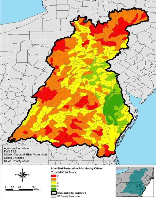
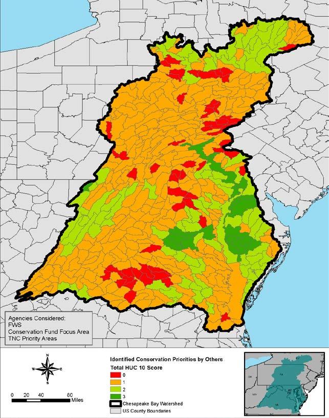
13 PRIORITIES BY OTHERS 13
14 WATERSHED DEGRADATION 14 What subwatersheds are the most degraded? Can we summarize the primary problems regionally? Pertinent data: Percent impervious cover Percent forest Percent forested riparian buffer Impaired streams on 303(d) list-% of stream length impaired in subwatershed CBP Stream IBI rating in subwatershed CBP - N and P top 25% of all Chesapeake Bay NHD catchments for N and P yields, respectively
15 WATERSHED DEGRADATION - PROPOSED SCORING SCHEME 15 Parameter Data Source Metric Scoring Landuse (measures of landscape alterations from development) Chesapeake Conservancy 2016 Chesapeake Conservancy 2016 EPA 2010 (Army Comp Plan) Percent impervious cover. Scoring based on MDNR General Guidelines for Impervious Surface Thresholds. Percent forest cover. Scoring based on goals set and relationships determined in USFS State of Chesapeake Forests (2006) Percent of stream network within subwatershed with forest (riparian buffer). Scoring based on goals set and relationships determined in USFS State of Chesapeake Forests (2006). 0 = >25% 1 = 10-25% 2 = 2-10 % 3 = <2 % 0 = 0-30% 1 => =>37-51% 3 = >51 0 = 0-56% 1 = >56-63% 2 = >63-70% 3 = >70% Stream health- water quality 303(d) Impaired waterways list (EPA) Stream miles listed as impaired within subwatershed (scoring based on groups determined using Natural Breaks Method (Jenks) in GIS). 0 = = = = 0 Stream health- biological integrity Chesapeake Bay Program Benthic Index of Biotic Integrity (watershed-wide B- IBI) Subwatershed rating assigned by Chesapeake Bay Program based on B- IBI determined by stream monitoring. 0 = NA 1 = poor or very poor 2 = good or fair 3 = excellent Nitrogen and Phosporus Impairments SPARROW model output Top 25 % of all Chesapeake Bay NHD catchments for nitrogen and phosphorus yields 0 = a subwatershed in the top 25% for N and P 1 = a subwatershed in the top 25% for N or P 3 = not a subwatershed in the top 25% for N or P

16 CONNECTIVITY ANALYSIS 16 Where are the corridors and other landscape features that are critical connectors in the watershed? Pertinent Data: RCOA (Regional Conservation Opportunity Areas) connector habitats

17 SOCIOECONOMIC ANALYSIS 17 What locations are important for recreation and public access? Where are minority and low income populations located (underserved)? What locations are important for water supply and source water protection? What locations are important due to cultural or historical significance? Pertinent Data: Water quality protection areas National, state, and local parks Public access points Minority populations Low income populations
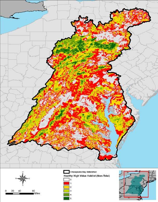
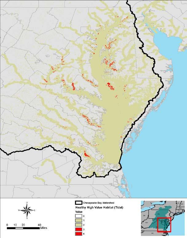
18 HEALTHY/HIGH VALUE HABITATS 18 Where are the healthy habitats in the watershed? Performed 2 analyses one focused on the watershed and one focused on the mainstem and shoreline Pertinent data-watershed compilation: State-identified healthy watersheds Brook Trout catchments Index of Ecological Integrity Audubon Important Bird Areas RCOA Core and connectors Black Duck Focus Areas Pertinent data mainstem/shoreline Oyster reefs potential oyster habitat Existing brook trout streams SAV beds Nesting locations of wading and waterbirds
19 19 HEALTHY/HIGH VALUE HABITATS
20 THREATS ANALYSIS 20 What areas are threatened by urbanization and climate change in the watershed? What areas are prone to increased/persistent flooding in the future? Pertinent data: Eroding shorelines/vulnerable shorelines Uncontrolled N and P loads USACE SLR curves Areas threatened by more frequent normal flooding Resources at risk to coastal storms Non-tidal flooding Tidal marsh migration corridors Future projected development National Fish Habitat Assessment (risk of current habitat degradation) FWS data

21 CANDIDATE RESTORATION PROJECTS 21 Received 14 candidate restoration projects from 11 agencies Cost range: $40K - $30M Screening process Incorporate into implementation strategy FY 2019 budget
22 ECOSYSTEM SERVICES 22 Ecosystem goods and services are socially valued aspects or outputs of ecosystems that depend on self-regulating or managed ecosystem structures and processes. Some examples: water purification & waste treatment, human health, natural hazard mitigation, property & infrastructure protection, human safety, navigation, recreation, climate regulation, carbon sequestration Feedback requested: 1. What are good resources/references that provide information on ecosystem services, preferably in the Chesapeake Bay? 2. What projects have you implemented or planned where you evaluated ecosystem services? 3. Did you have funding partners, and if so, who that were interested in implementation for eco services? to
 Are there innovative financing strategies that you have used to implement projects?")
23 IMPLEMENTATION PROGRAMS AND FINANCING 23 Feedback requested: 1) What partnership programs have helped you implement a project? Examples: PA - Growing greener program EPA - Section 319 2) Are there innovative financing strategies that you have used to implement projects? to Anna.M.Compton@usace.army.mil


24 NEXT STEPS 24 Stakeholder webinar - June Draft Report for review Fall 2017 Final Report - Summer 2018

25 WE WANT TO HEAR FROM YOU! 25 All the slides and content (including some additional background slides) will be posted on the study website and add website. or with follow-up questions. Priority feedback: Restoration Opportunity Analyses. Selected subwatersheds for Tier 3 analyses for each jurisdiction.
CHESAPEAKE BAY COMPREHENSIVE WATER RESOURCES AND RESTORATION PLAN
 CHESAPEAKE BAY COMPREHENSIVE WATER RESOURCES AND 255 255 255 237 237 237 0 0 0 217 217 217 163 163 163 200 200 200 131 132 122 239 65 53 80 119 27 RESTORATION PLAN 110 135 120 252 174.59 112 92 56 62 102
Habitat Grant Projects Clinton River Watershed
 Habitat Grant Projects Clinton River Watershed L Y N N E S E Y M O U R E N V I R O N M E N T A L E N G I N E E R O F F I C E O F T H E M A C O M B C O U N T Y P U B L I C W O R K S C O M M I S S I O N
Annual Update. Large-Scale Oyster Restoration in Support of the Chesapeake Bay Agreement Oyster Goal. Stephanie Reynolds Westby, NOAA
 Annual Update Large-Scale Oyster Restoration in Support of the Chesapeake Bay Agreement Oyster Goal Stephanie Reynolds Westby, NOAA Susan Conner, USACE- Norfolk District Policy Drivers Executive Order
Regional Watershed Planning. Calumet Summit 2010: A Call to Connect Calumet Conference Center April 27, 2010
 Regional Watershed Planning Calumet Summit 2010: A Call to Connect Calumet Conference Center April 27, 2010 Basins The Calumet Region Watershed Communities Land Cover- 2006 Impervious Cover 303d Listed
Chapter Three: Discussion and Conclusion. 3.1 Introduction/Overview. 3.2 Countywide Stream Assessment
 3.1 Introduction/Overview The objective of this study was to develop a stream prioritization tool that evaluates stream reaches in terms of the potential water quality improvements that could be achieved
Upper Mississippi River Conference 2016 Action Agenda: Raise the Grade
 Upper Mississippi River Conference 2016 Action Agenda: Raise the Grade December 16, 2016 On Oct. 13 14, 2016, a partnership of river stakeholders hosted the ninth annual Upper Mississippi River Conference,
Science Plan. Executive Summary. Introduction
 Science Plan Executive Summary This Science Plan will establish and define the focus of the Peninsular Florida Landscape Conservation Cooperative (PFLCC) science investments. The data and products derived
North Dakota s Nutrient Reduction Strategy. Presented to the 2016 ND Water Quality Monitoring Conference March 4, 2016
 North Dakota s Nutrient Reduction Strategy Presented to the 2016 ND Water Quality Monitoring Conference March 4, 2016 Nutrients Nutrients, in appropriate amounts, are essential to the growth and health
Climate Change, Marsh Erosion and the Chesapeake Bay TMDL
 Climate Change, Marsh Erosion and the Chesapeake Bay TMDL Rising sea level in Chesapeake Bay is inexorable. One environmental effect associated with sea level rise is marsh erosion. Marsh erosion can impact
SAV Monitoring Program
 SAV Monitoring Program ~Sustainability and funding challenges~ J. Brooke Landry STAR 5.26.16 Are there any fatal flaws regarding the SAV Management Strategy and Twoyear work plan? SAV Monitoring Program
Biological Uplift in Stream Restoration Projects. September 20, Presentation by: Wetlands and Waterways Program
 Biological Uplift in Stream Restoration Projects September 20, 2017 Presentation by: Wetlands and Waterways Program Integrated Water Planning Program Maryland Department of the Environment Wetlands & Waterways
A Summary Guide to the. Rifle River WATERSHED MANAGEMENT PLAN. Know Your Watershed Protect Its Resources
 A Summary Guide to the Rifle River WATERSHED MANAGEMENT PLAN Know Your Watershed Protect Its Resources Table of Contents The Watershed... 3 The Management Plan... 4 Designated and Desired Uses... 5 Sources
FREQUENTLY ASKED QUESTIONS: URBAN STREAM RESTORATION BMP. David Wood Chesapeake Stormwater Network. Lisa Fraley-McNeal Center for Watershed Protection
 FREQUENTLY ASKED QUESTIONS: David Wood Chesapeake Stormwater Network URBAN STREAM RESTORATION BMP Lisa Fraley-McNeal Center for Watershed Protection Bill Stack Center for Watershed Protection FREQUENTLY
Hudson Raritan Estuary Comprehensive Restoration Plan and Feasibility Study
 Restoring America s Estuaries 5 th National Conference on Coastal and Estuarine Habitat Restoration 16 November 2010 Hudson Raritan Estuary Comprehensive Restoration Plan and Feasibility Study Lisa Baron
Overview - Institute for for Water Water Resources
 Overview - http://www.iwr.usace.army.mil/ Institute for for Water Water Resources Society of American Military Engineers (SAME) Critical Infrastructure Resiliency Seminar Marriah S. Abellera George W.
Municipal Stormwater Management Planning
 Municipal Stormwater Management Planning Christopher C. Obropta, Ph.D., P.E. Water Resources Extension Specialist with Rutgers Cooperative Extension Assistant Professor with Department of Environmental
Riparian Forest Buffer (RFB) Management Strategy CBP Work Plan Virginia
 Management Strategy CBP Work Plan Virginia") Riparian Forest Buffer (RFB) Management Strategy CBP Work Plan Virginia Goal: Vital Habitats: Restore, enhance and protect a network of land and water habitats to support fish and wildlife, and to afford
Riparian Forest Buffer (RFB) Management Strategy CBP Work Plan Virginia Goal: Vital Habitats: Restore, enhance and protect a network of land and water habitats to support fish and wildlife, and to afford
South St. Vrain / Hall Meadows Restoration Planning August 20, 2015
 South St. Vrain / Hall Meadows Restoration Planning August 20, 2015 Agenda Introductions Purpose & Goals of Meeting Planning Area Master Plan Restoration Planning: Cost Estimates, Grants, Scope, Timeline
WATERSHED MANAGEMENT INITIATIVE: GOALS & IMPLEMENTATION OBJECTIVES, JULY 26, 1999
 WATERSHED MANAGEMENT INITIATIVE: GOALS & IMPLEMENTATION OBJECTIVES, JULY 26, 1999 The following table indicates the draft goals and objectives for the Santa Clara Basin WMI process. The overall objectives
West Fork White River Watershed Conservation Map Summaries. Prepared for the Beaver Watershed Alliance. By the Watershed Conservation Resource Center
 West Fork White River Watershed Conservation Map Summaries Prepared for the Beaver Watershed Alliance By the Watershed Conservation Resource Center November 2014 The Watershed Conservation Resource Center
Ecosystem Service Tradeoffs in the Implementation of the Bay TMDL
 Ecosystem Service Tradeoffs in the Implementation of the Bay TMDL Lisa A. Wainger 1 and Jay Messer 2 1 University of Maryland Center for Environmental Science 2 Retired; formerly of US EPA Office of Research
Natural Resources and Climate Resiliency in Germantown
 Natural Resources and Climate Resiliency in Germantown Ingrid Haeckel, Andrew Meyer, and Elizabeth Murphy NYSDEC Hudson River Estuary Program and Cornell University Presentation to the Town of Germantown,
John Vile, MS Water Monitoring & Standards Bureau of Freshwater and Biological Monitoring
 NJ Fish Index of Biotic Integrity John Vile, MS Water Monitoring & Standards Bureau of Freshwater and Biological Monitoring Program Objectives Determine the current Status of fish communities, which reflect
Healthy Watersheds Assessment. Potomac Watersheds in West Virginia
 Healthy Watersheds Assessment Potomac Watersheds in West Virginia Watershed Assessment - Goals Develop metrics to measure current condition/function & threats Rank watersheds for restoration & protection
Climate Change and Chesapeake Bay Habitats
 Climate Change and Chesapeake Bay Habitats Donna Marie Bilkovic STAC Chesapeake Bay Forage Base Workshop 12 November 2014 http://www.chesapeake.org/stac/ Virginia Institute of Marine Science www.ccrm.vims.edu
FY2012. Progress Report. Strategy for Protecting and Restoring the Chesapeake Bay Watershed. Executive Order March 28, 2013
 arrows wings Tail outline head shield Executive Order 13508 Progress Report Strategy for Protecting and Restoring the Chesapeake Bay Watershed March 28, 2013 FY2012 D e v e l o p e d b y t h e Fe d e r
Coastal Resource Management Planning
 College of William and Mary W&M Publish Reports Spring 2011 Coastal Resource Management Planning Center for Coastal Resources Management, Virginia Institute of Marine Science Follow this and additional
The newly updated and comprehensive SWMP shall:
 RFQ SCOPE OF SERVICES 2.1 Project Purpose The City of Miami, ( City ) is seeking professional engineering services from a qualified firm for the purpose of planning and developing a newly updated and comprehensive
Building Resilient Communities - Low Impact Development and Green Infrastructure Strategies
 Building Resilient Communities - Low Impact Development and Green Infrastructure Strategies October 24, 2013 Bridgewater State University E. Heidi Ricci Senior Policy Analyst Mass Audubon Shaping the Future
US Army Corps of Engineers and Stream Restoration Permitting
 US Army Corps of Engineers and Stream Restoration Permitting Jack Dinne US Army Corps of Engineers-Baltimore Maryland Section Northern May 6, 2014 US Army Corps of Engineers Presentation Overview Corps
Mike Langland USGS PA Agricultural Advisory Board April 28, 2016
 Mike Langland USGS PA Agricultural Advisory Board April 28, 2016 Chesapeake Bay Nontidal Monitoring Network - Loads to the Bay (1) How are nitrogen, phosphorus, and suspendedsediment loads responding to
Raritan River Basin. How to protect quality & quantity of water resources? Land Protection and Management to Protect Water Resources
 Land Protection and Management to Protect Water Resources New Jersey Water Supply Authority: Kathy Hale, Principal Watershed Protection Specialist (908) 685-0315 x228 khale@raritanbasin.org Jen Zhang,
Minnesota River Basin Interagency Study
 650 Minnesota River Basin Interagency Study Agencies collaborate for basin water quality and ecosystem restoration in Minnesota, Iowa, North Dakota, and South Dakota A multi-state effort is underway to
Credit Valley Conservation (CVC) Board of Directors. Chief Administrative Officer (CAO) Watershed Knowledge. Watershed Management
 Board of Directors. Chief Administrative Officer (CAO) Watershed Knowledge. Watershed Management") Credit Valley Conservation (CVC) Board of Directors Chief Administrative Officer (CAO) CVC Foundation Human Resources Corporate Watershed Knowledge Watershed Watershed Transformation Planning and Development
Credit Valley Conservation (CVC) Board of Directors Chief Administrative Officer (CAO) CVC Foundation Human Resources Corporate Watershed Knowledge Watershed Watershed Transformation Planning and Development
FINAL DATA REPORT. Jay Kilian Scott Stranko Jason Frentress
 FINAL DATA REPORT Aquatic Conservation Targets: prioritization of streams in need of restoration and protection and the assessment of stream conditions in 2005 Watershed Restoration Action Strategy (WRAS)
Pacific Northwest Region, Forest Service Basin-scale Restoration Prioritization Process
 Pacific Northwest Region, Forest Service Basin-scale Restoration Prioritization Process Pacific Northwest Region U.S.D.A. Forest Service Dave Heller, Regional Fish Program Leader Bruce McCammon, Regional
Public Notice. Applicant: City of Dallas Project No.: SWF Date: April 18, Name: Chandler Peter Phone Number:
 Public Notice Applicant: City of Dallas Project No.: SWF- 2014-00151 Date: April 18, 2014 The purpose of this public notice is to inform you of a proposal for work in which you might be interested. It
APPENDIX H Guidance for Preparing/Reviewing CEQA Initial Studies and Environmental Impact Reports
 APPENDIX H H.1 Guidance for Preparing and Reviewing CEQA Initial Studies Step 1: Consider the Project Characteristics as Provided by the Project Applicant Review the project application and draft plan
Riparian Buffers and Stream Restoration
 Riparian Buffers and Stream Restoration Why focus on riparian areas? Link land and water on any given site and link landscapes together in a watershed Riparian corridors protect the circulatory system
A Freshwater Blueprint for Maritime Canada
 A Freshwater Blueprint for Maritime Canada Union of Nova Scotia Municipalities (UNSM) November 8 th, 2017 William Millar Aquatic Conservation Biologist william.millar@natureconservancy.ca Craig Smith Conservation
A GIS Tool Prioritizing Dams for Removal within the State of North Carolina Kat Hoenke Southeast Aquatic Resources Partnership (SARP)
") A GIS Tool Prioritizing Dams for Removal within the State of North Carolina Kat Hoenke Southeast Aquatic Resources Partnership (SARP) Cape Fear River Partnership Meeting May 15-16, 2014 Project Background
A GIS Tool Prioritizing Dams for Removal within the State of North Carolina Kat Hoenke Southeast Aquatic Resources Partnership (SARP) Cape Fear River Partnership Meeting May 15-16, 2014 Project Background
DAKOTA COUNTY SOIL AND WATER CONSERVATION DISTRICT COMPREHENSIVE PLAN
 DAKOTA COUNTY SOIL AND WATER CONSERVATION DISTRICT COMPREHENSIVE PLAN 2011-2015 4100 220 th Street West, Suite 102 Farmington, MN 55024 651-480-7777 www.dakotacountyswcd.org I. INTRODUCTION A. Purpose
Polluted Runoff and Land Conservation: What s the Connection?
 Polluted Runoff and Land Conservation: What s the Connection? Caroly Shumway, Ph.D. Executive Director, Merrimack River Watershed Council In partnership with NMCOG Overview Purpose Of This Talk Is To Convey
INteractive STream Assessment Resource Biological Monitoring Program
 Page 1 of 9 INteractive STream Assessment Resource Biological Monitoring Program Thumbnail Not Available Tags WADEABLE STREAMS, Habitat, Watersheds, Streams, BENTHOS, Fish, biota, environment, Biology,
Chapter 4 Watershed Goals and Objectives
 Chapter 4 Watershed Goals and Objectives Eight (8) long-term watershed goals have been developed by the NEW Watershed Advisory Group (WAG) after consideration of discussions held during monthly watershed
The Whole Basin Management
 INTRODUCTION The Whole Basin Management approach, developed by the Department of Natural Resources and Environmental Control (the Department), focuses on protecting Delaware s environment by managing it
Walnut Creek Watershed Management Authority. Project Kick Off March 18, 2015
 Walnut Creek Watershed Management Authority Project Kick Off March 18, 2015 Agenda Schedule & Meeting Purpose Meeting Purpose TMDL Raccoon River TMDL Impaired by Nitrate and E.coli Includes Walnut Creek
Hydrologic and Ecologic Impacts from the CERP Indian River Lagoon South Project
 Hydrologic and Ecologic Impacts from the CERP Indian River Lagoon South Project Dr. Gretchen Ehlinger Senior Biologist US Army Corps of Engineers Jacksonville District November 15, 2016 AWRA Conference
Quantifying the Benefits of Stream Restoration
 Quantifying the Benefits of Stream Restoration 10 th Annual GAFM Technical Conference, March 2016 Jarrod Karl, Hazen and Sawyer Presentation Outline Benefits of Stream Restoration The Watershed Approach
The Next Generation of Mitigation: Linking Current and Future Mitigation Programs with State Wildlife Action Plans and Other State and Regional Plans
 : Linking Current and Future Mitigation Programs with State Wildlife Action Plans and Other State and Regional Plans August 4, 2009 Jessica B. Wilkinson, James M. McElfish, Jr., and Rebecca Kihslinger
Engineering with Nature for Natural Infrastructure
 Engineering with Nature for Natural Infrastructure Dr. Todd S. Bridges Senior Research Scientist, Environmental Science U.S. Army Engineer Research and Development Center, USACE todd.s.bridges@usace.army.mil
Gulf of Mexico Program
 Gulf of Mexico Program Gulf of Mexico Program Mission Protect, restore, and maintain the Gulf of Mexico in ways consistent with the economic well-being of the region Committed to voluntary, non-regulatory
Living Shorelines & Coastal Resiliency: A Consultants Perspective. Presented by: Bethany Bearmore, P.E. Louis Berger
 Living Shorelines & Coastal Resiliency: A Consultants Perspective Presented by: Bethany Bearmore, P.E. Louis Berger Living Shorelines & Coastal Resiliency A Consultants Perspective 1. Why 2. Process 3.
Preliminary data from nontraditional
 Preliminary data from nontraditional monitoring census Lea Rubin, Izaak Walton League Anne Dunkel, Alliance for the Chesapeake Bay June 22, 2016 Integrated Monitoring Networks Workgroup Preliminary site
Water and Environment. Monterey Peninsula, Carmel Bay and South Monterey Bay Integrated Regional Water Management Draft Plan
 Water and Environment Monterey Peninsula, Carmel Bay and South Monterey Bay Integrated Regional Water Management Draft Plan December 11, 2006 Presentation Outline Purpose of IRWM Planning Status of Plan
Harte Research Institute for Gulf of Mexico Studies
 Harte Research Institute for Gulf of Mexico Studies Gulf of Mexico Ecosystem Services Workshop David W. Yoskowitz, Cristina Carollo, and Carlota Santos Harte Research Institute for Gulf of Mexico Studies
TORCH LAKE TOWNSHIP WATER QUALITY ACTION PLAN
 TORCH LAKE TOWNSHIP WATER QUALITY ACTION PLAN Elk-River-Chain-of-Lakes Gaps Analysis Project The Watershed Center Grand Traverse Bay Tip of the Mitt Watershed Council Michigan Department of Natural Resources
Council of Governments
 Metropolitan Washington Council of Governments Anne Arundel County Draft Phase II Watershed Implementation Plan January 18, 2011 Chesapeake Bay TMDL Pollutants of Concern Nitrogen Phosphorus Sediment 2
Planning and Combination (Planning and Acquisition) Project Proposal
 Project Proposal") Planning and Combination (Planning and Acquisition) Project Proposal Project Number 15-1308 Project Name Asotin County Geomorphic/Watershed Assessment Sponsor Asotin County Conservation District List all
Planning and Combination (Planning and Acquisition) Project Proposal Project Number 15-1308 Project Name Asotin County Geomorphic/Watershed Assessment Sponsor Asotin County Conservation District List all
GIWW Brazos River Floodgates and Colorado River Locks Feasibility Study
 GIWW Brazos River Floodgates and Colorado River Locks Feasibility Study Stakeholder Partnering Forum Modernizing of the GIWW August 4, 2016 Partnering Under a Systems Approach for Sustaining Commercial
Maryland s Living Shorelines Program. Bhaskaran Subramanian February 27, 2015
 Maryland s Living Shorelines Program Bhaskaran Subramanian February 27, 2015 1 Erosion & traditional approaches Living shorelines- what is it? Maryland s Living Shorelines program LS Law Products Funding-
The total population of the township is 9,942 (2015 Five-Year American Community Survey [ACS]). The median household income is over $109,000.
![The total population of the township is 9,942 (2015 Five-Year American Community Survey [ACS]). The median household income is over $109,000.](/thumbs/72/67990406.jpg "The total population of the township is 9,942 (2015 Five-Year American Community Survey [ACS]). The median household income is over $109,000.") East Bradford Township, Pennsylvania Motivated by watershed impairment caused by suburban development over the past 30 years, a township with a full slate of water quality improvement programs looks outside
East Bradford Township, Pennsylvania Motivated by watershed impairment caused by suburban development over the past 30 years, a township with a full slate of water quality improvement programs looks outside
DRAFT Introduction:
 Introduction: Bay Area Macroinvertebrate Bioassessment Information Network San Francisco Bay Area Creeks Benthic Index of Biotic Integrity (IBI) Draft IBI Workplan v.4 The following describes a series
U.S. Army Corps of Engineers Reservoir Operations Maria Placht, Institute for Water Resources, USACE 49
 U.S. Army Corps of Engineers Reservoir Operations Maria Placht, Institute for Water Resources, USACE 49 Context The U.S. Army Corps of Engineers (the Corps) is responsible for a variety of water resourcerelated
SECTION 6: MITIGATION STRATEGY
 SECTION 6: MITIGATION STRATEGY This section describes the process by which the Lehigh Valley Steering Committee and municipal planning partnership performed the update to the county and local mitigation
PA Municipal Separate Storm Sewer System (MS4) TMDL Plan
 TMDL Plan") PA Municipal Separate Storm Sewer System (MS4) TMDL Plan Instructor: Bryan Seipp, Watershed Manager- CWP Lee Epstein, Director, Lands Program- CBF 1 To Adjust How the Slides Appear on Your Screen To make
PA Municipal Separate Storm Sewer System (MS4) TMDL Plan Instructor: Bryan Seipp, Watershed Manager- CWP Lee Epstein, Director, Lands Program- CBF 1 To Adjust How the Slides Appear on Your Screen To make
VIDEO: Riparian Forest Buffers: The Link Between Land & Water
 VIDEO: Riparian Forest Buffers: The Link Between Land & Water Introduction to Riparian Buffers Adapted from: Riparian Forest Buffers: The Link Between Land & Water. Maryland Cooperative Extension. Wye
719 Griswold, Suite 820 Detroit, MI DANVERS POND DAM REMOVAL AND STREAM RESTORATION PROJECT
 Great Lakes Restoration Initiative Grant Final Report US EPA Grant GL 00E006 43 October, 2013 Valley Woods Wetland Southfield Lola Valley Grow Zone Wayne County Parks Venoy Park Grow Zone Wayne County
AP Environmental Science
 AP Environmental Science Types of aquatic life zones MARINE Estuaries coral reefs mangrove swamps neritic zone pelagic zone FRESHWATER lakes and ponds streams and rivers wetlands Distribution of aquatic
The Importance of the Pearl River to Mississippi s Estuarine Habitats Jennifer Buchanan Education Coordinator
 The Importance of the Pearl River to Mississippi s Estuarine Habitats Jennifer Buchanan Education Coordinator 2006 Pearl River Basin Symposium May 5-6, 2006 Topics for Discussion What s an estuary? Pearl
Coastal Texas Protection and Restoration Project
 Coastal Texas Protection and Restoration Project Sharon Tirpak / Sheridan Willey / Janelle Stokes Project Management / Planning / Environmental USACE, Galveston District August 2014 US Army Corps of Engineers
OUR MISSION: To preserve, protect, and restore Delaware s Inland Bays the water that flows into them and the watershed around them.
 OUR MISSION: To preserve, protect, and restore Delaware s Inland Bays the water that flows into them and the watershed around them. OUR In 1988, the Delaware Inland Bays were declared an estuary of national
CITY OF GRIFFIN STREAM BANK RESTORATION PROGRAM
 CITY OF GRIFFIN STREAM BANK RESTORATION PROGRAM Lee Phillips 1, J. Erik Alford2 and M. Brad McLeod 3 AUTHORS: 'Project Engineer, Integrated Science & Engineering, 118 North Expressway, Griffin, GA 30223;
3 Objectives 3 Ob jec tives
 3 Objectives 3 Objectives 3 Objectives 3 Objectives contents Objective number Page 3.1 Ki uta ki tai: mountains to the sea O1-O5 37 3.2 Beneficial use and development O6-O13 38 3.3 Māori relationships
Climate Change: Impacts, Monitoring, and Solutions
 Climate Change: Impacts, Monitoring, and Solutions 1 Responding to Climate Change 1. Projections/Impacts 2. Adaptation and Resiliency 3. Monitoring 4. What about emissions? 2 Native trout and salmon are
VILLAGE OF BELLAIRE WATER QUALITY ACTION PLAN
 VILLAGE OF BELLAIRE WATER QUALITY ACTION PLAN Elk-River-Chain-of-Lakes Gaps Analysis Project The Watershed Center Grand Traverse Bay Tip of the Mitt Watershed Council Michigan Department of Natural Resources
ADDRESSING CLIMATE CHANGE ADAPTATION IN EASTERN ONTARIO APRIL 15, 2013
 ADDRESSING CLIMATE CHANGE ADAPTATION IN EASTERN ONTARIO APRIL 15, 2013 IPCC DEFINITION UNFCCC DEFINITION Climate change in Intergovernmental Panel on Climate Change (IPCC) usage refers to a change in the
Environment & Conservation Introduction
 Environment & Conservation Introduction Anacortes is blessed with an abundance of natural beauty. Residents identify marine shorelines, streams, lakes, forested areas, and other natural features as defining
Project Goals and Scoping
 Prepared for: Boulder County, Colorado Flood Planning & Preliminary Design Services for South St. Vrain Creek Restoration at Hall Ranch and Scoping May 24, 2016 Meeting with General Public In association
Assessment of the Health of Santa Ana River Watershed
 Assessment of the Health of Santa Ana River Watershed 1. 1.0 Introduction Human well-being is inextricably tied to the services provided by healthy ecosystems and yet vulnerable to the increased threats
Criteria for Identifying and Prioritizing Habitat Protection and Restoration Projects on the Lower Columbia River and Estuary*
 Criteria for Identifying and Prioritizing Habitat Protection and Restoration Projects on the Lower Columbia River and Estuary* Ecosystem Criteria 1) Habitat Connectivity (0-10 points) This criterion recognizes
The status of aquatic ecosystems in the Basin
 AQUATIC SPECIES AND HABITATS The status of aquatic ecosystems in the Basin is influenced by both natural and human processes. The geologic and geomorphic processes described earlier formed and continue
NDCEE. Ecosystem Banking Best Practices. Elizabeth Keysar, NDCEE/CTC. National Defense Center for Energy and Environment
 NDCEE Ecosystem Banking Best Practices DoD Executive Agent Office Office of the of the Assistant Assistant Secretary of the of Army the Army (Installations and and Environment) Elizabeth Keysar, NDCEE/CTC
Decision Support Framework for Restoring Connectivity and Enhancing Resilience as Part of Gulf Coast Restoration
 Decision Support Framework for Restoring Connectivity and Enhancing Resilience as Part of Gulf Coast Restoration David Hanson - HansonRM NCER 2016 Coral Springs, FL April 20, 2016 Role of Connectivity
The Currituck Sound Array: Introducing a new estuarine field site and test bed for Corps research. RSM Webinar, 18 February 2016
 The Currituck Sound Array: Introducing a new estuarine field site and test bed for Corps research. RSM Webinar, 18 February 2016 Heidi M. Wadman, Patrick J. Dickhudt U.S. Army Research and Development
WATER QUALITY IMPROVEMENT PLAN CATCHMENT MANAGEMENT AREA REPORT. 19 Pioneer River Main Channel
 WATER QUAITY IMPROVEMENT PAN - CATCHMENT MANAGEMENT AREA REPORT 19 Pioneer River Main Channel Relianc KOIJO SEAFORTH BA BAY St Helens MOUNT OSSA Pioneer River Main Channel: MAP 1 SUBCATCHMENT ANDUSE Murray
CERP System Status Reports The Evolution from
 CERP System Status Reports The Evolution from 2006-2009 Eliza Hines 22 July 2009 Everglades Restoration Comprehensive Everglades Restoration Plan (CERP) 18,000 sq mile ecosystem Everglades & South Florida
From the thousands of miles of coastal shoreline
 Water Resources VALUE OF OUR NATION S WATER RESOURCES From the thousands of miles of coastal shoreline and rivers to the lakes and wetlands that dot our nation s landscape, America is fortunate to have
Report to N.C. Legislative Commission on Global Climate Change March 15, 2010
 Summary of March 2010 Planning for North Carolina s Future: Ask the Climate Question Climate Change Adaptation Workshop hosted by N.C. Interagency Leadership Team And Next Steps Report to N.C. Legislative
C O M P R E H E N S I V E P R O T E C T I O N & R E S T O R AT I O N P L A N. f or th e
 C O M P R E H E N S I V E P R O T E C T I O N & R E S T O R AT I O N P L A N f or th e R O S S B A R NE T T R E SERV O I R WATERS HED, MI S S I S S I P P I E X E C U T I V E S U M M A R Y O C T O B E R
June 22, Francis E. Borcalli, P.E.
 CACHE CREEK SETTLING BASIN SYMPOSIUM Managing the Settling Basin Who s Doing What! June 22, 2009 Francis E. Borcalli, P.E. CACHE CREEK SETTLING BASIN SYMPOSIUM Managing the Settling Basin Who s Doing What!
Project Steering Committee Kickoff Meeting Notes Wood-Pawcatuck Watershed Flood Resiliency Management Plan March 26, 2015
 Project Steering Committee Kickoff Meeting Notes Wood-Pawcatuck Watershed Flood Resiliency Management Plan March 26, 2015 Attendees: Denise Poyer, Wood-Pawcatuck Watershed Association Chris Fox, Wood-Pawcatuck
DECISION MEMO. West Fork Blacktail Deer Creek Hardened Crossing
 Page 1 of 6 Background DECISION MEMO USDA Forest Service Madison Ranger District Madison County T12S, R4W, Section 30 The project is in the Gravelly Landscape, Snowcrest Recommended Wilderness Management
NIAGARA RIVER WATERSHED MANAGEMENT PLAN (Phase 1) Buffalo Sewer Authority (BSA), Long Term Control Plan, Buffalo: BSA, 2012
 Buffalo Sewer Authority (BSA), Long Term Control Plan, Buffalo: BSA, 2012") Bibliography Alden, M., Mortsch, L., Sheraga, J., Climate Change & Water Quality in the Great Lakes Region: Risks, Opportunities & Responses. Detroit: Report of the Great Lakes Water Quality Board to the
Bibliography Alden, M., Mortsch, L., Sheraga, J., Climate Change & Water Quality in the Great Lakes Region: Risks, Opportunities & Responses. Detroit: Report of the Great Lakes Water Quality Board to the
Dead-Zones and Coastal Eutrophication: Case- Study of Chesapeake Bay W. M. Kemp University of Maryland CES Horn Point Laboratory Cambridge, MD
 Dead-Zones and Coastal Eutrophication: Case- Study of Chesapeake Bay W. M. Kemp University of Maryland CES Horn Point Laboratory Cambridge, MD Presentation to COSEE Trends Orientation at UMCES HPL 4 August
The Chesapeake Bay Blueprint:
 PHASE II The Chesapeake Bay Blueprint: THE BEST HOPE FOR RESTORING CLEAN WATER THIS NATION HAS EVER SEEN Peter McGowan/U.S. Fish and Wildlife Service Strategic Plan 2016-2020 The Chesapeake Bay Foundation
ILF Instrument Development and Execution. The North Carolina Experience September 15, 2010
 ILF Instrument Development and Execution The North Carolina Experience September 15, 2010 Presentation Overview EEP Background Instrument Development Process Content of Agreement Q&A (but feel free to
Culvert Prioritization Model: Aiding Communities in the Selection of Priority Restoration Projects
 Culvert Prioritization Model: Aiding Communities in the Selection of Priority Restoration Projects SNHPC Meeting January 24, 2017 1 Undersized Culverts! Culvert Sizes (~7,500 VT culverts) 6,000 5,000 69%