Methods of Streamflow Analysis
|
|
|
- Crystal Anis Moody
- 6 years ago
- Views:
Transcription

1 4 Methods of Streamflow Analysis
; Intermittent flows only during wet season; Ephemeral flows for short periods")


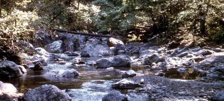
2 CHAPTER 4 Streamflow Measurements Danielle M. Andrews Department of Crop and Soil Sciences, The Pennsylvania State University I. INTRODUCTION Perennial carries water all year (> 90% of the time); Intermittent flows only during wet season; Ephemeral flows for short periods following rain or snowmelt Baseflow portion of flow in stream supplied by groundwater Stormflow portion of flow in stream supplied by runoff during precipitation events Recent boosts in urbanization and technology to meet society s ever increasing demands have added to the growing awareness of and concern for the environment. Research, planning, design, operation, maintenance, and enforcement of laws with respect to water conservation and water quality control, all rely on flow measurements. Hence, strict legislation and continuing public interest in conservation and environmental matters have highlighted the significance of flow measurements. Understanding the flow of water into and through stream channels is critical to the development of stream restoration initiatives. At a minimum it is helpful to know whether a stream is perennial, intermittent, or ephemeral and the relative contributions of baseflow and stormflow to stream discharge. Other desirable information include the relative frequency and duration of extreme high and low flows and the duration of certain stream levels. Streamflow or discharge (Q) is the flow of water in streams. Specifically, it is the volume of water passing a point in a given time, and it is comprised of baseflow and stormflow. Streamflow is measured at a location along the stream from the water velocity and the cross sectional flow area. The main objective of this chapter is to describe various common techniques for measuring streamflow.


3 52 Andrews II. SPECIFIC METHODS Measuring Techniques Floating Objects: One of the simplest ways to measure discharge is to observe the time it takes a floating object to travel a given distance. A measurement of the cross sectional of the stream should be made simultaneously, such that, Q = VA where Q = discharge (m 3 /sec); V = velocity (m/sec); and A = cross sectional area(m 2 ) This method is not always accurate, especially for large streams, since velocity varies from point to point with depth and width over the cross section of the stream. Generally, actual velocity is about 80 85% of surface velocity. Stream Gauging: If the cross section of a stream is divided into finite vertical sections, the velocity profile can be approximated by individually measuring the mean velocity of each section using a flow meter. The area of each section can be determined, and the mean discharge of the entire stream is then computed as follows: Q = VA Example of a flow meter The greater the number of subsections, the more accurate the value of Q will be. a) Depths > 0.5m, two measurements made at 20 and 80% of the stage (the height of a stream s water surface above a reference elevation (sea level, gauge level)) and averaged b) Depths < 0.5m, one measurement made at 60% depth


4 Chapter 4 Methods of Streamflow Analysis 53 Example of a gauging station. Gauging stations are located along a stream to record stream water level over time Developing Rating Curves: Simply put, rating curves are developed by stream gauging multiple times, at different flows, seasons etc. Float gauges use a buoyant ball which rises and falls with increases and decreases in water surface level. Pressure transducers can be installed below the water surface to monitor increasing pressure as the water level rises and decreasing pressure as the water level falls. These devices can be connected to data loggers to record the water level over time. Rating Curves Stream discharge will decrease as stream stage and cross sectional area decreases. The relationship between stage and discharge is unique for a gauging station. A graph of measured stream stages and discharges at the gauging station defines this relationship. A curve that best represents the position of the data points is called a best fit curve. This curve is referred to as the stream s rating curve. The rating curve is crucial because it allows the use of stream stage, which is usually easily determined, to estimate the corresponding streamflow.
 Weirs: Weirs are structures built into the stream that force the water to flow through an opening of a known size and shape.")

 Flumes: Flumes are artificial open channels built to contain flow within a designed cross section and length.")
5 54 Andrews Precalibrated Structures: On small watersheds, (<800 ha), precalibrated structures are often used because of their convenience and accuracy. The most common of these are weirs and flumes. Weir with V shaped notch 1) Weirs: Weirs are structures built into the stream that force the water to flow through an opening of a known size and shape. A weir includes all components of a stream gauging station as well as a notch control. The notch can be V shaped, rectangular or trapezoidal. Building a weir in a stream essentially involves damming it. Weirs may be constructed of any material that blocks flow, such as concrete. It is important that water flows through the notch, as the height of flow through the notch must be measurable. Leakage around the sides and bottom of the weir must be eliminated or minimized. B A 2) Flumes: Flumes are artificial open channels built to contain flow within a designed cross section and length. There is no impoundment, but the height of water in the flume is measured with a stilling well. An example of a flume is the Parshall flume. Measurement of the height of water in the flume allows one to calculate discharge. Other examples include, the HS, H and HL type flumes used for measuring intermittent runoff; the Venturi flume used for measuring irrigation water; and the San Dimas Flume which measures debris laden flows in mountain streams. Examples of a flume (A) and a stilling well (B)

 V = (1.")
. Table of Manning's n for Channels Type of Channel and Description Minimum Normal Maximum Natural streams minor streams (top width at floodstage < 100 ft) Main Channels a.")
6 Chapter 4 Methods of Streamflow Analysis 55 Estimation Techniques Often times, streamflow data is needed where there are no gauges, especially in rural areas. An estimation of streamflow is often necessary in order to predict flow or approximate past flows in these areas. One of the main interests is flood flow. However, it should be noted that no matter how sophisticated the estimation method is; direct measurements are always better. Manning s Equation: Manning s Equation is a common empirical method used to estimate discharge at known depths of flow. (Recall Q = VA) V = (1.49/n) (R h 2/3 ) (s 1/2 ) Where, n = a roughness coefficient (see table below); R h = the hydraulic radius (ft) = A/WP (WP = wetted perimeter (ft)); s = energy slope as approximated by the water surface slope (ft/ft). Table of Manning's n for Channels Type of Channel and Description Minimum Normal Maximum Natural streams minor streams (top width at floodstage < 100 ft) Main Channels a. clean, straight, full stage, no rifts or deep pools b. same as above, but more stones and weeds c. clean, winding, some pools and shoals d. same as above, but some weeds and stones e. same as above, lower stages, more ineffective slopes and sections f. same as "d" with more stones g. sluggish reaches, weedy, deep pools h. very weedy reaches, deep pools, or floodways with heavy stand of timber and underbrush Mountain streams, no vegetation in channel, banks usually steep, trees and brush along banks submerged at high stages a. bottom: gravels, cobbles, and few boulders b. bottom: cobbles with large boulders

7 56 Andrews Mechanisms that cause changes in streamflow Natural mechanisms Runoff from rainfall and snowmelt Evaporation from soil and surface water bodies Transpiration by vegetation Ground water recharge from surface water bodies Sedimentation of lakes and wetlands Human induced mechanisms River flow regulation for hydropower and navigation Construction, removal, and sedimentation of reservoirs Stream channelization and levee construction Drainage or restoration of wetlands Land use changes such as urbanization III. SUMMARY Streams are dynamic and complex systems. Healthy stream systems are dependent on streamflow. The flow of water in stream channels is responsible for the transport of sediment, nutrients, and pollution downstream. However, streamflow varies with precipitation, temperature and other climatic factors. As such, the ability to accurately measure streamflow is key to effectively managing our water resources as well as predicting floods and estimating long term trends in water and sediment discharges. Food for Thought a. Consider each technique for measuring streamflow. Where is error introduced into the calculations? b. What precautions should be taken to obtain the best estimates of mean depth and velocity, when choosing stream gauging to calculate streamflow? c. Describe the relationship between streamflow and society.
8 Chapter 4 Methods of Streamflow Analysis 57 IV. References 1. Brooks, Kenneth N., Peter F. Ffolloitt, Hans M. Gregersen, and Leonard F. DeBano. Hydrology and the Management of Watersheds rd Ed. Iowa State Press, Ames, Iowa. 2. Grant, Douglas M. and Brian D. Dawson. Isco Open Channel Flow Measurement Handbook th Ed. Isco, Inc., Lincoln, NE. 3. Hauer, F. Richards, and Gary A. Lamberti. Methods in Stream Ecology nd Ed. Academic Press, San Diego, CA. 4. Sanders, Laura L. A Manual of Field Hydrogeology Prentice Hall, Upper Saddle River, NJ. 5. Stream Corridor Restoration: Principles, Processes, and Practices. Federal Interagency Stream Restoration Working Group Chapter 7. Washington, D.C Streams.
Stream Reaches and Hydrologic Units
 Chapter United States 6 Department of Agriculture Natural Resources Conservation Service Chapter 6 Stream Reaches and Hydrologic Units Rain clouds Cloud formation Precipitation Surface runoff Evaporation
Hydrology and Water Management. Dr. Mujahid Khan, UET Peshawar
 Hydrology and Water Management Dr. Mujahid Khan, UET Peshawar Course Outline Hydrologic Cycle and its Processes Water Balance Approach Estimation and Analysis of Precipitation Data Infiltration and Runoff
CHAPTER FIVE Runoff. Engineering Hydrology (ECIV 4323) Instructors: Dr. Yunes Mogheir Dr. Ramadan Al Khatib. Overland flow interflow
 Instructors: Dr. Yunes Mogheir Dr. Ramadan Al Khatib. Overland flow interflow") Engineering Hydrology (ECIV 4323) CHAPTER FIVE Runoff Instructors: Dr. Yunes Mogheir Dr. Ramadan Al Khatib Overland flow interflow Base flow Saturated overland flow ١ ٢ 5.1 Introduction To Runoff Runoff
Engineering Hydrology (ECIV 4323) CHAPTER FIVE Runoff Instructors: Dr. Yunes Mogheir Dr. Ramadan Al Khatib Overland flow interflow Base flow Saturated overland flow ١ ٢ 5.1 Introduction To Runoff Runoff
The Islamic University of Gaza- Civil Engineering Department Sanitary Engineering- ECIV 4325 L5. Storm water Management
 The Islamic University of Gaza- Civil Engineering Department Sanitary Engineering- ECIV 4325 L5. Storm water Management Husam Al-Najar Storm water management : Collection System Design principles The Objectives
1.6 Influence of Human Activities and Land use Changes on Hydrologic Cycle
 1.6 Influence of Human Activities and Land use Changes on Hydrologic Cycle Watersheds are subjected to many types of changes, major or minor, for various reasons. Some of these are natural changes and
Understanding. Hydraulics. palgrave macmillan. Les Hamill. University of Plymouth THIRD EDITION
 Understanding Hydraulics THIRD EDITION Les Hamill Senior Lecturer in Civil Engineering, School of Marine Science and Engineering, University of Plymouth palgrave macmillan Preface to third edition Acknowledgements
Measuring discharge. Climatological and hydrological field work
 Measuring discharge Climatological and hydrological field work 1. Background Discharge (or surface runoff Q s) refers to the horizontal water flow occurring at the surface in rivers and streams. It does
4.2 Discharge measurement by Velocity Area Method (Chitale, 1974)
") 4.2 Discharge measurement by Velocity Area Method (Chitale, 1974) This method comprises measuring the mean velocity V and the flow area 'A' and computing the discharge Q from the continuity equation. The
4.2 Discharge measurement by Velocity Area Method (Chitale, 1974) This method comprises measuring the mean velocity V and the flow area 'A' and computing the discharge Q from the continuity equation. The
What Are Environmental (Instream) Flows?
 Flows?") 1 What Are Environmental (Instream) Flows? Sustainable water management requires that both human needs and the needs of aquatic and riparian ecosystems be fulfilled. Dams and diversion of water for municipal
1 What Are Environmental (Instream) Flows? Sustainable water management requires that both human needs and the needs of aquatic and riparian ecosystems be fulfilled. Dams and diversion of water for municipal
Water Measurement. Presentation by. L. Niel Allen Extension Irrigation Specialist Utah State University
 Water Measurement Presentation by L. Niel Allen Extension Irrigation Specialist Utah State University to Utah State Engineer s Office Division of Water Rights Salt Lake City, Utah December 11, 2013 Introduction
Standards for Soil Erosion and Sediment Control in New Jersey May 2012 STANDARD FOR GRASSED WATERWAYS. Definition. Purpose
 STANDARD FOR GRASSED WATERWAYS Definition A natural or constructed watercourse shaped or graded in earth materials and stabilized with suitable vegetation for the safe conveyance of runoff water. Purpose
Session A6- Mannings "n" roughness characteristic occurring in semi-smooth turbulent flow of nature- Iike fishways
 University of Massachusetts - Amherst ScholarWorks@UMass Amherst International Conference on Engineering and Ecohydrology for Fish Passage International Conference on Engineering and Ecohydrology for Fish
Vegetation Management and Water Yield: Silver Bullet or a Pipe Dream?
 Vegetation Management and Water Yield: Silver Bullet or a Pipe Dream? Lee H. MacDonald rofessor Emeritus and Senior Research Scientist Watershed Science/NREL Colorado State University, Fort Collins, CO
M.L. Kavvas, Z. Q. Chen, M. Anderson, L. Liang, N. Ohara Hydrologic Research Laboratory, Civil and Environmental Engineering, UC Davis
 Assessment of the Restoration Activities on Water Balance and Water Quality at Last Chance Creek Watershed Using Watershed Environmental Hydrology (WEHY) Model M.L. Kavvas, Z. Q. Chen, M. Anderson, L.
Index. Page numbers followed by f indicate figures.
 Index Aerodynamic method, 103, 110 111 Algae, 131, 173, 175 Alternate depth, 88 Alternating block method, 132, 140 141 Attenuation, 106, 107f, 118, 120 Page numbers followed by f indicate figures. Baseflow
Constructed Wetland Pond T-8
 Constructed Wetland Pond T-8 Description A constructed wetlands pond is a shallow retention pond designed to permit the growth of wetland plants such as rushes, willows, and cattails. Constructed wetlands
Constructed Wetland Channel T-9
 Description A constructed wetland channel is a conveyance BMP that is built, in part, to enhance stormwater quality. Constructed wetland channels use dense vegetation to slow down runoff and allow time
Biogeochemistry of Wetlands: Wetland hydrology
 Institute of Food and Agricultural Sciences (IFAS) Wetland hydrology, transport processes, and modeling June 23-26, 2008 Gainesville, Florida Wetland Biogeochemistry Laboratory Soil and Water Science Department
Stormwater Local Design Manual For Houston County, Georgia
 Stormwater Local Design Manual For Houston County, Georgia Adopted November 15, 2005 TABLE OF CONTENTS 1. FORWARD... 1 2. GENERAL LEVEL OF SERVICE STANDARDS... 2 2.1. DETENTION REQUIREMENTS... 2 2.1.1.
Flow Measuring Structures
 Flow Measuring Structures Flow measurement structures are required in irrigation canals in order to facilitate the distribution of water through out the system and to keep account for seepage losses, etc.
Overview of NRCS (SCS) TR-20 By Dr. R.M. Ragan
 TR-20 By Dr. R.M. Ragan") Overview of NRCS (SCS) TR-20 By Dr. R.M. Ragan TR-20 is a computer program for the simulation of runoff occurring from a single storm event. The program develops flood hydrographs from runoff and routes
Overview of NRCS (SCS) TR-20 By Dr. R.M. Ragan TR-20 is a computer program for the simulation of runoff occurring from a single storm event. The program develops flood hydrographs from runoff and routes
Municipal Stadium Wetland
 W A T E R S H E D F A C T S Total watershed area 140 mi 2 Average annual rainfall 38 in Average annual temperature 58 F Elevation Max 1321 ft Min 899 ft C. J. Brown Reservoir controls flow from 83 mi 2
Created by Simpo PDF Creator Pro (unregistered version) Asst.Prof.Dr. Jaafar S. Maatooq
 Asst.Prof.Dr. Jaafar S. Maatooq") Lect.No.9 2 nd Semester Barrages, Regulators, Dams 1 of 15 In order to harness the water potential of a river optimally, it is necessary to construct two types of hydraulic structures, as shown in Figure
Lect.No.9 2 nd Semester Barrages, Regulators, Dams 1 of 15 In order to harness the water potential of a river optimally, it is necessary to construct two types of hydraulic structures, as shown in Figure
Drop Height For Channel Erosion Control
 Drop Height For Channel Erosion Control James C.Y. Guo, Professor and Director Department of Civil Engineering, U. of Colorado at Denver, Denver, Colorado 8017 E-mail: James.Guo@cudenver.edu Introduction
MODEL Stormwater Local Design Manual. City of Centerville
 MODEL Stormwater Local Design Manual City of Centerville Adopted December 6, 2005 TABLE OF CONTENTS 1. FORWARD... 1 2. GENERAL LEVEL OF SERVICE STANDARDS... 1 2.1. DETENTION REQUIREMENTS... 1 2.1.1. Discharge
Water Balance Methodology
 Water Balance Methodology Integrating the Site with the Watershed and the Stream March 2012 An initiative under the umbrella of the Water Sustainability Action Plan for British Columbia Water Balance Methodology
EFFECTS OF WATERSHED TOPOGRAPHY, SOILS, LAND USE, AND CLIMATE ON BASEFLOW HYDROLOGY IN HUMID REGIONS: A REVIEW
 PROGRESS IN PHYSICAL GEOGRAPHY EFFECTS OF WATERSHED TOPOGRAPHY, SOILS, LAND USE, AND CLIMATE ON BASEFLOW HYDROLOGY IN HUMID REGIONS: A REVIEW KATIE PRICE 2011 Presented by: Jordan Martin Article Overview
Freight Street Development Strategy
 Freight Street Development Strategy Appendix B: Naugatuck River Floodplain Analysis Freight Street Development Strategy DECEMBER 2017 Page B-1 1.0 NAUGATUCK RIVER FLOODPLAIN AT FREIGHT STREET 1.1 Watershed
6.0 Runoff. 6.1 Introduction. 6.2 Flood Control Design Runoff
 October 2003, Revised February 2005 Chapter 6.0, Runoff Page 1 6.1 Introduction 6.0 Runoff The timing, peak rates of discharge, and volume of stormwater runoff are the primary considerations in the design
CHAPTER 3 Environmental Guidelines for WATERCOURSE CROSSINGS GOVERNMENT OF NEWFOUNDLAND AND LABRADOR DEPARTMENT OF ENVIRONMENT AND LABOUR
 GOVERNMENT OF NEWFOUNDLAND AND LABRADOR DEPARTMENT OF ENVIRONMENT AND LABOUR CHAPTER 3 Environmental Guidelines for WATERCOURSE CROSSINGS WATER RESOURCES MANAGEMENT DIVISION Water Investigations Section
History of Model Development at Temple, Texas. J. R. Williams and J. G. Arnold
 History of Model Development at Temple, Texas J. R. Williams and J. G. Arnold INTRODUCTION Then Model development at Temple A long history (1937-present) Many scientists participating in: Data collection
Ponds. Pond A water impoundment made by excavating a pit, or constructing a dam or an embankment.
 POND SITE SELECTION AND CONSTRUCTION Uses, Planning, & Design David Krietemeyer Area Engineer USDA-NRCS June 20, 2008 Uses Considerations for Location of Commonly Used Terms Pond A water impoundment made
2
 1 2 3 4 5 6 The program is designed for surface water hydrology simulation. It includes components for representing precipitation, evaporation, and snowmelt; the atmospheric conditions over a watershed.
Functional Uplift Based Stream Assessment & Restoration Design
 Functional Uplift Based Stream Assessment & Restoration Design Darcy K.L. Turner Senior Environmental Scientist, Biohabitats, Inc. (dturner@biohabitats.com) Christopher A. Streb, PE Ecological Engineer,
Outlet Structure Modeling
 Watershed Modeling using HEC-RAS Outlet Structure Modeling Jeff Wickenkamp, P.E., CFM, D.WRE Patrick Lach, P.E. Hey and Associates, Inc. Water Resources, Wetlands and Ecology Outline of Presentation Why
Geneva Dam. Design of a Steep, Temporary, Riprap Ramp
 Geneva Dam Design of a Steep, Temporary, Riprap Ramp A Run-of of-river Dam Analysis for Geneva Dam Credit to: Yu-Chun Su, Ph.D., P.E., CFM David T. Williams. Ph.D., P.E, CFM Presentation Purpose History
Definitions 3/16/2010. GG22A: GEOSPHERE & HYDROSPHERE Hydrology
 GG22A: GEOSPHERE & HYDROSPHERE Hydrology Definitions Streamflow volume of water in a river passing a defined point over a specific time period = VxA discharge m 3 s -1 Runoff excess precipitation - precipitation
UNIT HYDROGRAPH AND EFFECTIVE RAINFALL S INFLUENCE OVER THE STORM RUNOFF HYDROGRAPH
 UNIT HYDROGRAPH AND EFFECTIVE RAINFALL S INFLUENCE OVER THE STORM RUNOFF HYDROGRAPH INTRODUCTION Water is a common chemical substance essential for the existence of life and exhibits many notable and unique
Introduction. Welcome to the Belgium Study Abroad Program. Courses:
 Introduction Welcome to the Belgium Study Abroad Program Courses: AGSM 335: Soil and Water Management BAEN 460: Principals of Environmental Hydrology BAEN 460 / AGSM 335 Combined lecture and HW sessions
DIVISION 5 STORM DRAINAGE CRITERIA
 DIVISION 5 STORM DRAINAGE CRITERIA Section 5.01 GENERAL The following storm drainage design criteria shall apply to all storm drainage designs in the City. Additional design criteria are specified in the
(b) Discuss in brief shaft spillway with neat sketches. Marks 04. OR Q (2) Explain in brief USBR stilling basin. Marks 08
 Discuss in brief shaft spillway with neat sketches. Marks 04. OR Q (2) Explain in brief USBR stilling basin. Marks 08") (b) Discuss in brief shaft spillway with neat sketches. Marks 04 OR Q (2) Explain in brief USBR stilling basin. Marks 08 Stilling Basins The basins are usually provided with special appurtenances including
(b) Discuss in brief shaft spillway with neat sketches. Marks 04 OR Q (2) Explain in brief USBR stilling basin. Marks 08 Stilling Basins The basins are usually provided with special appurtenances including
Implementing Stormwater Management through Split-Flow Drainage Design
 Implementing Stormwater Management through Split-Flow Drainage Design Stuart Patton Echols PhD, ASLA, RLA Assistant Professor - Department of Landscape Architecture 210 Engineering Unit D Center for Watershed
Standards for Soil Erosion and Sediment Control in New Jersey May 2012 STANDARD FOR SLOPE PROTECTION STRUCTURES. Definition
 STANDARD FOR SLOPE PROTECTION STRUCTURES Definition Structures to safely conduct surface runoff from the top of a slope to the bottom of the slope. Purpose The purpose of this practice is to convey storm
Staged and Notched Labyrinth Weir Hydraulics
 Utah State University DigitalCommons@USU International Junior Researcher and Engineer Workshop on Hydraulic Structures Jun 17th, 12:00 AM - Jun 20th, 12:00 AM Staged and Notched Labyrinth Weir Hydraulics
Chapter 7 Water Conveying Conduits
 Chapter 7 Water Conveying Conduits After the capacity of the water conduit system is known, the type and size of the supply and drainage conduits have to be determined, which is an iterative process. Various
The Clean Water Act Waters of the US Proposed Rule -- What is it and what are the implications for agriculture?
 The Clean Water Act Waters of the US Proposed Rule -- What is it and what are the implications for agriculture? August 1, 2014 1 Acronyms and Terms Agencies CWA WOTUS Rule FEMA USGS Environmental Protection
Best Management Practice Fact Sheet 14: Wet Ponds
 Publication 426-133 Best Management Practice Fact Sheet 14: Wet Ponds David J. Sample, Assistant Professor and Extension Specialist, Biological Systems Engineering, Virginia Tech Stefani Barlow, Undergraduate
Issue paper: Aquifer Water Balance
 Issue paper: Aquifer Water Balance 1. Introduction And Background 1.1. Purpose and Scope The population in Kitsap County has grown rapidly in recent years and is expected to increase substantially in the
Prepared for Urban Drainage and Flood Control District
 BERM FAILURE TECHNICAL ANALYSES SOUTH PLATTE GRAVEL PIT EVALUATION CRITERIA Prepared for Urban Drainage and Flood Control District Wright Water Engineers, Inc. January 2013 121-030.000 TABLE OF CONTENTS
Water Resources on PEI: an overview and brief discussion of challenges
 Water Resources on PEI: an overview and brief discussion of challenges Components: Components and links Atmospheric water Surface water (including glacial water) Groundwater Links: Precipitation (atm(
Runoff Processes. Daene C. McKinney
 CE 374 K Hydrology Runoff Processes Daene C. McKinney Watershed Watershed Area draining to a stream Streamflow generated by water entering surface channels Affected by Physical, vegetative, and climatic
ALABAMA S BEST MANAGEMENT PRACTICES. Protection of Water Quality During Timber Harvesting
 ALABAMA S BEST MANAGEMENT PRACTICES Protection of Water Quality During Timber Harvesting Water Quality Responsibility Landowners and/or involved professional forestry practitioners such as: Forest resource
Suspended Sediment Discharges in Streams
 US Army Corps of Engineers Hydrologic Engineering Center Suspended Sediment Discharges in Streams April 1969 Approved for Public Release. Distribution Unlimited. TP-19 REPORT DOCUMENTATION PAGE Form Approved
Urbanization effects on the hydrology of the Atlanta area, Georgia (USA)
") 14/06/01 Impact of Human Activity on Groundwater Dynamics (Proceedings of a symposium held during the Sixth IAHS Scientific Assembly at Maastricht, The Netherlands, July 2001). IAHS Publ. no. 269, 2001.
14/06/01 Impact of Human Activity on Groundwater Dynamics (Proceedings of a symposium held during the Sixth IAHS Scientific Assembly at Maastricht, The Netherlands, July 2001). IAHS Publ. no. 269, 2001.
Earth Science Chapter 6 Section 1 Review
 Name: Class: Date: Earth Science Chapter 6 Section 1 Review Multiple Choice Identify the choice that best completes the statement or answers the question. 1. What process is illustrated by the arrows labeled
Application for resource consent Form B Damming and diversion of water
 Application for resource consent Form B Damming and diversion of water Notes Resource use activities must meet all the conditions of any relevant Permitted Activity Rules in the Waikato Regional Plan or
Lyon Creek Cedar Way Stormwater Detention Dam Operation and Maintenance Manual
 Lyon Creek Cedar Way Stormwater Detention Dam Operation and Maintenance Manual Prepared by: Mike Shaw Stormwater Program Manager City of Mountlake Terrace January 2010 Section I General Information This
1. Stream Network. The most common approach to quantitatively describing stream networks was postulated by Strahler (1952).
.") 1. Stream Network The most common approach to quantitatively describing stream networks was postulated by Strahler (1952). First Order Streams streams with no tributaries. Second Order Streams begin at
1. Stream Network The most common approach to quantitatively describing stream networks was postulated by Strahler (1952). First Order Streams streams with no tributaries. Second Order Streams begin at
Re-plumbing Roadside Ditch Networks
 Re-plumbing Roadside Ditch Networks Ditches Improving management to reduce flooding, water pollution, and in-stream erosion and habitat degradation Rebecca Schneider Dept. Natural Resources Cornell University,
STRAWMAN OUTLINE March 21, 2008 ISWS/ISGS REPORT ON THE OPPORTUNITIES AND CHALLENGES OF MEETING WATER DEMAND IN NORTH-EAST ILLINOIS
 STRAWMAN OUTLINE March 21, 2008 ISWS/ISGS REPORT ON THE OPPORTUNITIES AND CHALLENGES OF MEETING WATER DEMAND IN NORTH-EAST ILLINOIS REPORT TO BE DELIVERED TO THE RWSPG BY SEPTEMBER 30, 2008 Table of Contents
9.2 STANDARD CONSTRUCTED WETLANDS
 9.2 STANDARD CONSTRUCTED WETLANDS Standard constructed wetlands are stormwater management systems designed to maximize the removal of pollutants from stormwater runoff. Flow is directed through an engineered,
Software Applications for Runoff Hydrological Assessment
 Bulletin UASVM Horticulture, 67(2)/2010 Print ISSN 1843-5254; Electronic ISSN 1843-5394 Software Applications for Runoff Hydrological Assessment Severin CAZANESCU 1), Sorin CIMPEANU 1), Oana GUI 2), Dana
Effects of Antecedent Precipitation Index on the Rainfall-Runoff Relationship
 35 Bulgarian Journal of Agricultural Science, 12 (2006), 35-42 National Centre for Agrarian Sciences Effects of Antecedent Precipitation Index on the Rainfall-Runoff Relationship Ahmet ISTANBULLUOGLU 1,2,
Background. AEM Tier 2 Worksheet Stream & Floodplain Management. Glossary
 AEM Tier 2 Worksheet Stream & Floodplain Management Glossary Bankfull Stage: The stage at which water starts to flow over the flood plain; the elevation of the water surface at bankfull discharge. (This
Lecture 5 Hydrologic Cycle and Surface Hydrology
 LIMNOLOGY SPRING 2010 BIOL 362 / WMAN 446 Lecture 5 Hydrologic Cycle and Surface Hydrology 27 January 2009 Required Readings: Dodds. 2002. Chapter 4. Hydrology and Physiography of Groundwater and Wetland
Storm Sewer Design. Bob Pitt University of Alabama and Shirley Clark Penn State Harrisburg
 Storm Sewer Design Bob Pitt University of Alabama and Shirley Clark Penn State Harrisburg Major floods are dramatic and water flow routes must be recognized when minor drainage systems fail. These types
Uncertainty in Hydrologic Modelling for PMF Estimation
 Uncertainty in Hydrologic Modelling for PMF Estimation Introduction Estimation of the Probable Maximum Flood (PMF) has become a core component of the hydrotechnical design of dam structures 1. There is
Culvert Sizing procedures for the 100-Year Peak Flow
 CULVERT SIZING PROCEDURES FOR THE 100-YEAR PEAK FLOW 343 APPENDIX A: Culvert Sizing procedures for the 100-Year Peak Flow A. INTRODUCTION Several methods have been developed for estimating the peak flood
iswm TM Technical Manual Hydrology:
 : 1.0 2.0 Downstream Assessment 3.0 Streambank Protection 4.0 Water Balance 5.0 Rainfall Tables 6.0 Hydrologic Soils Data Table of Contents 1.0... HO-1 1.1 Estimating Runoff... HO-1 1.1.1 Introduction
Holly Swartz and Jason Shirey
 Chapter 105 General Permits for Stream and Wetland Impacts DEP Ch. 105 CONTACTS FOR BERKS COUNTY: Holly Swartz and Jason Shirey What DEP Regulates Under Chapter 105 Waters of the Commonwealth, which includes
Application of SWAT Model in land-use. change in the Nile River Basin: A Review
 Application of SWAT Model in land-use change in the Nile River Basin: A Review By: Marwa Ali, Okke Batelaan and Willy Bauwens 15-6-2011 Application of SWAT Model in land-use 1 change in the Nile River
Nutrient Management in. A presentation to the West Metro Water Alliance
 Nutrient Management in Developing and Agricultural Areas A presentation to the West Metro Water Alliance Chris Meehan, P.E. May 25, 2011 Agenda Physical Improvements Planning Improvements How to get it
Standards for Soil Erosion and Sediment Control in New Jersey May 2012 STANDARD FOR RIPRAP. Conditions Where Practice Applies
 STANDARD FOR RIPRAP Definition A layer of loose rock, aggregate, bagged concrete, gabions, or concrete revetment blocks placed over an erodible soil surface. Purpose The purpose of riprap is to protect
Water is everywhere on Earth oceans, glaciers, rivers, lakes, air,
 Section 6.1 6.1 Running Water 1 FOCUS Section Objectives 6.1 Explain how the water cycle circulates Earth s water supply in an unending cycle. 6.2 Explain how the water cycle is kept in balance. 6.3 Describe
Design of Hydro-meteorological Network
 Design of Hydro-meteorological Network 1 Hydro-Meteorological Network Design 1.1 Introduction A.K. Lohani Scientist F National Institute of Hydrology, Roorkee A hydro-metreological network is an organized
Yoshinaga Ikuo *, Y. W. Feng**, H. Hasebe*** and E. Shiratani****
 NITROGEN REMOVAL FUNCTION OF PADDY FIELD IN A CIRCULAR IRRIGATION SYSTEM Yoshinaga Ikuo *, Y. W. Feng**, H. Hasebe*** and E. Shiratani**** * National Institute for Rural Engineering, Tsukuba Science City
STATUS REPORT. Master of Science Programs ( GRADUATE STUDIES ) ARAB ACADEMY FOR SCIENCE, TECHNOLOGY COLLEGE OF ENGINEERING AND TECHNOLOGY
 ARAB ACADEMY FOR SCIENCE, TECHNOLOGY COLLEGE OF ENGINEERING AND TECHNOLOGY") ARAB ACADEMY FOR SCIENCE, TECHNOLOGY AND MARITIME TRANSPORT COLLEGE OF ENGINEERING AND TECHNOLOGY ( GRADUATE STUDIES ) Master of Science Programs STATUS REPORT NOVEMBER 2008 CONSTRUCTION AND BUILDING ENGINEERING
ARAB ACADEMY FOR SCIENCE, TECHNOLOGY AND MARITIME TRANSPORT COLLEGE OF ENGINEERING AND TECHNOLOGY ( GRADUATE STUDIES ) Master of Science Programs STATUS REPORT NOVEMBER 2008 CONSTRUCTION AND BUILDING ENGINEERING
APPENDIX A: STORMWATER HYDROLOGY
 APPENDIX A: STORMWATER HYDROLOGY In low impact development (LID), the objective of stormwater control measures (SCMs) is to mimic or replicate the hydrologic function of a natural system. This approach
POND CONSTRUCTION. Woodland Steward Series
 POND CONSTRUCTION Woodland Steward Series BOB TWOMEY DISTRICT CONSERVATIONIST USDA NATURAL RESOURCES CONSERVATION SERVICE COURSE OUTLINE DEFINITION OF A POND OR LAKE TYPES OF PONDS GEOLOGIC CONSIDERATIONS
Note that the Server provides ArcGIS9 applications with Spatial Analyst and 3D Analyst extensions and ArcHydro tools.
 Remote Software This document briefly presents the hydrological and hydraulic modeling software available on the University of Nice Server with Remote Desktop Connection. Note that the Server provides
EFFECT OF UPSTREAM DEVELOPMENT ON THE CLEAR CREEK AREA
 EFFECT OF UPSTREAM DEVELOPMENT ON THE CLEAR CREEK AREA Technical Memorandum Farming in the Floodplain Project Prepared for May 2017 PCC Farmland Trust Photo credit: Google Earth TABLE OF CONTENTS Page
CONTRIBUTION TO THE STUDY OF THE FLOW RESISTANCE IN A FLUME WITH ARTIFICIAL EMERGENT VEGETATION
 Larhyss Journal, ISSN 1112-3680, n 15, Septembre 2013, pp. 55-63 2013 Tous droits réservés CONTRIBUTION TO THE STUDY OF THE FLOW RESISTANCE IN A FLUME WITH ARTIFICIAL EMERGENT VEGETATION HAMIMED A., NEHAL
Urban Hydrology and Storm Water Management. iwater_3rd International Event Juan Jose Galan Vivas (Aalto University)
") Urban Hydrology and Storm Water Management iwater_3rd International Event Juan Jose Galan Vivas (Aalto University) OBJECTIVES of the LECTURE Provide the basics to understand the hydraulic factors and variables
Urban Hydrology and Storm Water Management iwater_3rd International Event Juan Jose Galan Vivas (Aalto University) OBJECTIVES of the LECTURE Provide the basics to understand the hydraulic factors and variables
Understanding Stormwater Pollution Prevention Plans (SWPPPs) (SWPPPS)
 (SWPPPS)") Understanding Stormwater Pollution Prevention Plans (SWPPPs) (SWPPPS) Definitions SWPPP: Storm Water Pollution Prevention Plan BMP: Best Management Practice(s) to control pollution IDNR: Iowa Department
Understanding Stormwater Pollution Prevention Plans (SWPPPs) (SWPPPS) Definitions SWPPP: Storm Water Pollution Prevention Plan BMP: Best Management Practice(s) to control pollution IDNR: Iowa Department
EFFLUENT DOMINATED WATER BODIES, THEIR RECLAMATION AND REUSE TO ACHIEVE SUSTAINABILITY
 EFFLUENT DOMINATED WATER BODIES, THEIR RECLAMATION AND REUSE TO ACHIEVE SUSTAINABILITY Chapter 9 Vladimir Novotny DEFINITION Effluent dominated water body Predominantly contains waste water effluents during
Temporary Watercourse Crossing: Culverts
 Temporary Watercourse Crossing: Culverts DRAINAGE CONTROL TECHNIQUE Low Gradient Velocity Control Short Term Steep Gradient Channel Lining Medium-Long Term Outlet Control Soil Treatment Permanent Symbol
Groundwater Balance Study in the High Barind, Bangladesh. A.H.M.Selim Reza 1, Quamrul Hasan Mazumder 1 and Mushfique Ahmed 1
 Rajshahi University J. of Sci. 39, 11-26 (2011) ISSN 1681-0708 Groundwater Balance Study in the High Barind, Bangladesh A.H.M.Selim Reza 1, Quamrul Hasan Mazumder 1 and Mushfique Ahmed 1 1 Department of
Sediment management of hydropower cascade: example of CNR run-of-river developments, French Rhone River, France
 Sediment management of hydropower cascade: example of CNR run-of-river developments, French Rhone River, France Christophe PETEUIL Compagnie Nationale du Rhone Engineering Department, River Systems and
The South Australian River Murray is a highly regulated system comprised of a series of
 1 2 The South Australian River Murray is a highly regulated system comprised of a series of lake-like pools with largely stable water levels. These relatively deep, slow moving pools of water with stable
Stream Simulation in Very Low Gradient Channels
 University of Massachusetts - Amherst ScholarWorks@UMass Amherst International Conference on Engineering and Ecohydrology for Fish Passage International Conference on Engineering and Ecohydrology for Fish
Constructed Wetland Use in Nonpoint Source Control
 Constructed Wetland Use in Nonpoint Source Control Description Constructed wetlands are excavated basins with irregular perimeters and undulating bottom contours into which wetland vegetation is purposely
STORMWATER MANAGEMENT: Emerging Planning Approaches and Control Technologies
 STORMWATER MANAGEMENT: Emerging Planning Approaches and Control Technologies Chapter 5 " HYDROLOGIC SYSTEMS " CHAPTER 5 5.1 INTRODUCTION 5.1.1 Training Objectives The objectives of this module are:! to
Climate Data Training Session April 26, 2017 Ontario Science Centre
 Adaptive Management To Address Climate Change Uncertainty in EA Process A Case Study of the Don Mouth Naturalization and Port Lands Flood Protection Project EA (DMNP EA) Climate Data Training Session April
POLICY FOR NATURAL RESOURCE MANAGEMENT AREAS
 POLICY FOR NATURAL RESOURCE MANAGEMENT AREAS I. POLICY STATEMENT Auburn University's (the University's) "Policy for Natural Resource Management Areas" implements the Campus Master Plan Land Use Element
Lift irrigation Using man or Animal power Using Mechanical or Electrical Power Flow irrigation a)inundation Irrigation b) Perennial Irrigation Direct
inundation Irrigation b) Perennial Irrigation Direct") Lift irrigation Using man or Animal power Using Mechanical or Electrical Power Flow irrigation a)inundation Irrigation b) Perennial Irrigation Direct irrigation Storage irrigation a)flow irrigation system:
Lift irrigation Using man or Animal power Using Mechanical or Electrical Power Flow irrigation a)inundation Irrigation b) Perennial Irrigation Direct irrigation Storage irrigation a)flow irrigation system:
Chapter 1. Introduction
 Chapter 1 Introduction James P. Heaney, Robert Pitt, and Richard Field Introduction Stormwater has traditionally been considered a nuisance, requiring rapid and complete drainage from areas of habitation.
Surface Water Sampling
 Surface Water Sampling Steve Howatt Who are we? CRO based out of Prince Edward Island, CANADA We have two research farms: New Glasgow, Prince Edward Island serving Zone 1 (1A) St Marc-sur-Richelieu, Quebec
Types of Hydropower Facilities
 Types of Hydropower Facilities 1 Impoundment Hydropower- uses a dam to store water. Water may be released either to meet changing electricity needs or to maintain a constant water level. 2 Run-of-River
Lecture 21: Groundwater: Hydraulic Conductivity
 Lecture 21: Groundwater: Hydraulic Conductivity Key Questions 1. What causes groundwater to move? 2. What is the hydraulic conductivity? 3. What is Darcy s Law? 4. How is groundwater velocity estimated?
Event and Continuous Hydrological Modeling with HEC- HMS: A Review Study
 Event and Continuous Hydrological Modeling with HEC- HMS: A Review Study Sonu Duhan *, Mohit Kumar # * M.E (Water Resources Engineering) Civil Engineering Student, PEC University Of Technology, Chandigarh,