Training on Roads for Water and Resilience
|
|
|
- Chastity Gilmore
- 6 years ago
- Views:
Transcription
1 Training on Roads for Water and Resilience 1


2 DRAINAGE FROM UNPAVED ROADS
3 Outline Introduction Important considerations Drainage management Surface drainage features Subsurface drainage features Additional measures In summary
4 1. Introduction 4 Drainage from unpaved roads is usually less developed: Yet maintenance problems to unpaved roads are largely caused by lacking drainage As a result sedimentation from unpaved roads can be 15% of sedimentation in upper catchment (data from Upper Tana Basin Kenya) And opportunities to harvest water are lost
5 2. Important considerations 5 For an effective drainage system ask yourself: Where is the water coming from? Where is the water going? Where should it be going? What treatment is needed to make it go there?
6 2. Important considerations 6 Important factors: I. Slope II. Gradient III. Hydrology
7 2. Important considerations 7 I. Slope = velocity of run-off Velocity increase: The volume of sediment that can be moved increases 4x when the velocity is doubled The size of particles that can be transported increases by 8 X when the velocity is doubled. As water depth increases, velocity increases because relative surface tension decreases. As water depth increases, velocity increases because relative surface tension decreases.
8 2. Important considerations 8 I. Slope = velocity of run-off Velocity decrease: Surface roughness, however, can reduce shear force and erodibility of the exposed surface. If the downslope is low gradient deposition and clogging will occur.
9 9
10 2. Important considerations 10 II. Gradient Ideal road grade: The longer the segment, the greater the potential for erosion. Grades ranging from 4-10% are ideal, with frequent grade reversals. Drainage is assured if the road reverses grade every meters. Water naturally exits the roadway at every grade reversal
11 2. Important considerations 11 Further implications of slope and grade for drainage Try to reverse the slope of the road and avoid long stretches As road grade steepens, drainage features must be closer together. Maintaining vegetative cover increases roughness and reduces erosion, Drainage features need to be more closely spaced on fine grained soils. Drainage features with grades less steep than the road surface or road ditch will tend to become clogged A well vegetated buffer zone or row of stones at the edge of the road will tend to disperse flow, reduce runoff velocity and collect sediment from road runoff. To keep drains self cleaning, ditches and the road surface need to have a slope equal to or greater than the contributing source of sediment. The faster the water, the more sediment it can transport at an increasing rate.
12 2. Important considerations 12 III. Hydrology Important hydrological factors: Number of stream crossings Side slope Moisture regime
13 3. Drainage Management 13 Water either infiltrates, evaporates or it will contribute to overland flow or run-off. The proportion of rainfall that becomes streamflow depends on: Size of drainage area: larger area means larger volume of run-off Topography: run-off volume increases with steepness of slope Soil: permeability and infiltration capacity
14 3. Drainage Management 14 Drainage of unpaved roads is critical to stand up to damaging effects of weather and traffic. And is moreover important for road water harvesting! First considerations for management of unpaved roads: Maintain natural vegetation, buffers and drainage ways Minimize the creation of steep slopes Integrate in landscape
15 3. Drainage management 15 What we know now: Drainage management for unpaved roads is important Enable water harvesting from unpaved roads 2 types of drainage: Surface drainage: Collect water from road surface and adjacent areas Subsurface drainage: Transport water through pores as subsurface flow
16 4. Surface drainage 16 Collect water from road surface, shoulders, side slopes and adjacent areas. Carry it away via slopes, ditches and pipes Purpose: To cause water to leave the road as shallow, non-erosive sheet flow, and enable harvesting of run-off water. In a direction and pattern to suit combinations of road material, slope and terrain.
17 4. Surface drainage 17 Ditches: Remove runoff quickly and reduce seepage into road subgrade Provide opportunity for sediments to be removed from run-off water before it enters surface waters or groundwater.
18 4. Surface drainage 18 Construction of ditches: Locate ditches on the up slope side to prevent water from flowing onto the road from uphill Design and grade ditches and bank side slopes at a maximum 2H:1V ratio Line ditches with a <5% slope with grass to filter sediments Line ditches with a >5% slope with riprap stone to prevent erosion Prevent water from standing in a ditch, this can weaken the road Check and clean ditches regularly, especially after major weather events
19 4. Surface drainage 19 Multiple measures and structures possible: 1. Road Crown & Cross-slope 2. Rolling dip 3. Water bar 4. Flat land drain 5. Cut-off drain 6. Cross drain 7. Filtrating bunds 8. Soil bund
20 4. Surface drainage Road crown & cross-slope Road profile is the crosssectional shape of the road surface Different road templates and drainage systems determine where water is collected and where it can be used
21 4. Surface drainage Road crown & cross-slope Centreline crown: sheds water to both sides of the roads from a highpoint in the road centre. Cross-slope: slope angle to one side of the road In-sloped: Drains water from entire road width toward the cut-bank or up-slope side. Used of steep hills, or with high flow velocities Out-sloped: Drains water toward a fill-bank or down-slope side. In order to avoid concentration of water in a ditch.

22 4. Surface drainage 22
23 4. Surface drainage Road crown & cross-slope Construction guidelines for grading: Grade roads when moist but not wet Do not grade when heavy rains are predicted Crown roads ½ to ¾ inch for each foot of road width, from roadcenter, to ensure good drainage Outslope roads with over-the-bank drainage problems entirely to the ditched side of the road


24 4. Surface drainage Rolling dip Most reliable cross drain for low standard roads: Used to drain roads having grades between 3 and 15% Function: collect surface runoff from the roadway and/or road ditch and direct the flow across and away from the roadway Broadly angled dip drain with a cross slope of 4-8%, steep enough to flush away accumulating sediments

25 4. Surface drainage Rolling dip Design is excavated cross drain
26 4. Surface drainage Rolling dip Benefits: Prevent erosion from water flowing down the road Acts as a cross drain outlet drainage from uphill side of the road Cheap, easy, and effective on low volume roads
27 4. Surface drainage Rolling dip Construction: Part of the road and the adjacent areas is excavated so as to lead the road run-off to adjacent land The excavated material from the dip is used to create to a higher area in the dirt road, making the road to slightly undulate and so create different drainage segments The velocity of flow must be sustained through the dip to prevent puddling and to keep sediment moving through the dip drain. Can be channeled to land or ponds
28 4. Surface drainage Rolling dip Considerations on slope: Too flat terrain (road grade less than 3% or cross slope less than 5%) Difficult to build a dip drain that will not lead to runoff. Instead make overland drain. Road grade too steep (greater than 15%) The roll-out will be too steep on the downhill side and traffic will damage the structure.

29 4. Surface drainage Rolling dip Make sure rolling dip goes to proper land!
30 4. Surface drainage Water bar A water bar is a pushed up mound of earth or hump on the roadway used to deflect runoff from the road surface. Quick, easy and cheap to build More effective when built at an angle of 30% to the slope grade. Waterbars are normally built to a height of cm above the road surface Protect drainage at outflow with stone, grass, sod or anything to reduce flow velocity.
31 4. Surface drainage Water bar Cross section of a waterbar
32 4. Surface drainage Water bar Spacing needed between water bars Slope <5% Diversion spacing (feet) (1 feet = 0.3 meter) % % % 50 >35% 25

33 4. Surface drainage Flat land drain A flat land drain is a type of grade break, a small increase in road elevation on a downhill slope. It causes water to flow off of the road surface to a lead-out ditch Gradient should be <2% Note: It is more difficult to apply for water harvesting
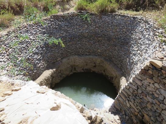
 This photo shows a cut-off drain that has been cut by a road grader for the purpose of diverting run-off water from")
34 4. Surface drainage Cut-off drain (turn out) This photo shows a cut-off drain that has been cut by a road grader for the purpose of diverting run-off water from the road into an adjacent field. They can be excavated by hand, or ox-scoops, to divert rainwater into borrow pits.
35 4. Surface drainage Cut-off drain Example of cut-off drain construction
36 4. Surface drainage Cut-off drain Spacing needed between cut-offs Road Grade (%) Distance (feet) (1 feet = 0.3 meters)

37 4. Surface drainage Cross drain Install a drain/pipe /culvert at an angle across the road considering natural drainage.
38 4. Surface drainage Cross drain Benefits: Reduction of bank erosion Pipe efficiency and flow capacity are increased when water does not have to make a sharp turn Possibility to continue stream flow Water harvesting options
39 4. Surface drainage Cross drain Considerations: Fill the cross pipe with material similar to existing road material Pipes should have headwalls and endwalls to reduce erosion Outlet the drain/culvert to a vegetated area, never directly into a stream
40 4. Surface drainage Cross drain Construction: Install culvert during period of low water flow Place culverts no more than 500 feet apart, and wherever needed due to crossing streams and steep slopes Ensure a slope of 0.5% or greater to allow for positive drainage flow Extra length of culvert should be considered to accommodate for headwalls Design culverts to handle at least a ten-year-frequency storm
41 4. Surface drainage Cross drain Culvert profile and cross-section
42 4. Surface drainage Cross drain Spacing needed between culverts Drainage area (acres) (1 acre = 0.4 hectare) Culvert diameter needed (inch) (1 inch = 2.54 cm) > Detailed design needed
43 4. Surface drainage Filtrating bunds Very low permeable bunds along the road made of boulder rocks (also called filtrating bunds, or diguette filtrante in French) Purpose: To decrease runoff speed and to spread runoff gently to the adjacent fields Bunds 3-4 m from the border of the road are very effective


44 4. Surface drainage Filtrating bunds

45 4. Surface drainage Filtrating bunds Niger: Stone bunds along road to reduce erosion

46 4. Surface drainage Filtrating bunds Combine with planting pits on upstream side

47 4. Surface drainage Soil bund Used to conduct run-off from cut-off drains to water storage structures Grass waterways for slopes up to 25% Steeper slopes, channel lined with stones, masonry or reinforced concrete
48 4. Surface drainage Soil bund Considerations: Dimension depends on expected discharge Diagonally across de slope not recommended, if they break or overtop can cause serious damage The preliminary position should be determined from a reconnaissance field survey Where possible, it should be located in a natural depression or drainage way. Should be inspected after every heavy storm
49 4. Surface drainage Soil bund
50 5. Subsurface drainage 50 Purpose: To collect subsurface water before it appears on road surface or in the ditch. Water which is collected can be directed to a water storage location Underdrain: drainage system under a road ditch to collect and transport subsurface water. Variety of shapes and sizes which allow water to enter the conduit, while keeping sediment out Consists of a trench parallel to the road with a free draining aggregate and perforated pipe to carry the water to an outlet
51 5. Subsurface drainage 51 Benefits: Low cost, easy to install Separate clean subsurface water from road runoff Decrease volume of water on road surface Allows water conduit to storage without overflow of road bank
52 6. Additional measures 52 Additional measures are useful for maintaining the drainage system over time. These measures include: Outlet protection Headwalls and endwalls Bank stabilization Vegetation Structures Combinations
53 6. Additional measures Outlet protection Outlet protection is important for the control of erosion at the outlet of a channel, culvert or ditch. It reduces the velocity of water and dissipates energy It serves as a type of buffer and removes sediments and other pollutants
54 6. Additional measures Outlet protection Structural outlet protection: Install at all pipe, culvert or other water diversion where erosion can occur For example with rock apron, riprap conveyance channel, splash/plunge pools and level spreaders. Non-structural Filter outlet protection: zones, natural buffers, vegetation
55 6. Additional measures Outlet protection (structural) Rock apron: Size and placement depends on culvert diameter and expected water flow. Only use this with a vegetative filter strip Riprap: Use riprap conveyance channel to remove sediments from runoff. Use on steep slopes where otherwise erosion would occur, and with an outlet that goes directly into surface waters.
56 6. Additional measures Outlet protection (structural) Splash/plunge pools: Detain water and allow sediment to settle out Use in areas with <10% slope to consolidate sediment for easier removal Level spreaders Should be flat (0% grade) to ensure uniform spreading of runoff Drainage area limited to 5 acres Stabilized with appropriate mixture of grass
57 6. Additional measures Outlet protection (non-structural) Filter zones: Natural sediment traps Slowing and filtering water before it enters surface waters If little/no vegetation exists, create or enhance a filter zone by planting diversity of native grasses, shrubs and trees. Routine and careful maintenance need to ensure healthy vegetation
58 6. Additional measures Outlet protection (non-structural) Recommended filter zone widths Slope of land between road and water Recommended filter zone widths (feet) (1 feet = 0.3 meters) 0-10% % % %
59 6. Additional measures Headwalls and endwalls Walls at the opening of a pipe to protect it from erosion due to waterflow. (Headwall at the inlet, endwall at the outlet.) Purpose: Support the road and protect the ends of a pipe. Also improve capacity and efficiency while reducing erosion. Necessity: water is turbulent when it changes direction, and water accelerates in a pipe, both increase erosive potential.


60 6. Additional measures Headwalls and endwalls Examples
61 6. Additional measures Headwalls and endwalls Benefits: Low-cost, long-lasting solution for erosion problems Prevent water flow to damage drainage structure and road Increase flow capacity of pipes by reducing turbulence and direction of flow
62 6. Additional measures Bank stabilization I. II. III. IV. Vegetation seeding Vegetation shrubs and trees Structures: walls/revetment systems Combinations of structures and vegetation
63 6. Additional measures Bank stabilization I. Vegetation seeding Effective and inexpensive method Stabilize bank or any bare area Grass and legumes slow the movement of water, allowing water to seep into the ground and minimize impact of runoff Surface should be left rough, to reduce water velocity and to help hold seed and mulch. Select preferably a native mix appropriate for site soil and drainage Mulch after seeding
64 6. Additional measures Bank stabilization II. Vegetation shrubs and trees Use live plant materials to stabilize steep slopes and stream banks Create vegetative filter zone Erosion control
65 6. Additional measures Bank stabilization III. Structures: walls/revetment systems Gabions: Rectangular wired mesh baskets filled with stone Slow velocity of runoff Protect slopes from erosion Riprap: Layer of large stones as a protective wall Place on roadside slopes and stream banks Use on steep slopes and in sharp turns Size of riprap depends on quantity and velocity of water flow
66 6. Additional measures Bank stabilization Combinations of structures and vegetation Vegetated gabion: IV. Combine a gabion wall with live branches Live branches root in gabions and slope, so binding gabions to the slope Vegetated riprap/joint planting: Plant live stakes and branches between the open spaces in the rocks. Roots improve drainage and reinforce the soil
67 7. In summary 67 Standing water, seeping water, rain, snow, ice, frost and even a lack of water can contribute to road maintenance needs. Unpaved roads often lack proper drainage and require continuous frequent re-grading or other costly maintenance activities. With better drainage: These costs are reduced Water harvesting potential is increased Sedimentation from roads is reduced


68 Supported by: Developed by:
PART 1 GENERAL REQUIREMENTS
 PART 1 GENERAL REQUIREMENTS Contract Closeout Plan 110 Arrow diagram for project close-out...3 Erosion Control 121 Straw bale barrier... 5 122 Silt fence... 7 123 Diversion dike... 9 124 Inlet protection...
Understanding Stormwater Pollution Prevention Plans (SWPPPs) (SWPPPS)
 (SWPPPS)") Understanding Stormwater Pollution Prevention Plans (SWPPPs) (SWPPPS) Definitions SWPPP: Storm Water Pollution Prevention Plan BMP: Best Management Practice(s) to control pollution IDNR: Iowa Department
Understanding Stormwater Pollution Prevention Plans (SWPPPs) (SWPPPS) Definitions SWPPP: Storm Water Pollution Prevention Plan BMP: Best Management Practice(s) to control pollution IDNR: Iowa Department
WEST VIRGINIA DIVISION OF FORESTRY STATE FOREST STANDARDS for LOGGING ROADS AND SKID TRAILS HAUL ROADS
 WEST VIRGINIA DIVISION OF FORESTRY STATE FOREST STANDARDS for LOGGING ROADS AND SKID TRAILS HAUL ROADS The objective of these specifications is to provide the construction requirements for haul roads and
Lyon Creek Cedar Way Stormwater Detention Dam Operation and Maintenance Manual
 Lyon Creek Cedar Way Stormwater Detention Dam Operation and Maintenance Manual Prepared by: Mike Shaw Stormwater Program Manager City of Mountlake Terrace January 2010 Section I General Information This
Ohio Department of Transportation Division of Production Management Office of Geotechnical Engineering. Geotechnical Bulletin
 Ohio Department of Transportation Division of Production Management Office of Geotechnical Engineering Geotechnical Bulletin GB 2 SPECIAL BENCHING AND SIDEHILL EMBANKMENT FILLS Geotechnical Bulletin GB2
Departments of Agronomy C709 Conservation Farming and Biological and Agricultural Engineering. Permanent grass cover
 Terrace Maintenance Photo 1. Measuring the ridge height above the channel is easily done with a straight board, carpenters level, and tape measure. Departments of Agronomy C709 Conservation Farming and
Filter Tube Barriers (Instream)
") Filter Tube Barriers (Instream) INSTREAM PRACTICES Flow Control No Channel Flow Dry Channels Erosion Control Low Channel Flows Shallow Water Sediment Control High Channel Flows Deep Water Symbol Photo
Filter Tube Barriers (Instream) INSTREAM PRACTICES Flow Control No Channel Flow Dry Channels Erosion Control Low Channel Flows Shallow Water Sediment Control High Channel Flows Deep Water Symbol Photo
10.1 INTRODUCTION 10.1 DRAINAGE
 CHAPTER 10 DRAINAGE 10.1 INTRODUCTION The drainage system manages both surface and subsurface water coming off the road surface and from the surrounding countryside. The purpose of the system is to ensure
Temporary Watercourse Crossing: Culverts
 Temporary Watercourse Crossing: Culverts DRAINAGE CONTROL TECHNIQUE Low Gradient Velocity Control Short Term Steep Gradient Channel Lining Medium-Long Term Outlet Control Soil Treatment Permanent Symbol
SUBSURFACE INFILTRATION SYSTEM DESCRIPTION. Alternative Names: Sump, Drywell, Infiltration Trench, Infiltration Galleries, Leach Fields
 4.1-d SUBSURFACE INFILTRATION SYSTEM Alternative Names: Sump, Drywell, Infiltration Trench, Infiltration Galleries, Leach Fields BMP DESIGN APPROACH Pollutant Source Control Hydrologic Source Control Stormwater
BIG O HDPE TUBING HDPE CORRUGATED TUBING FOR AGRICULTURAL, RESIDENTIAL AND HIGHWAY DRAINAGE INCREASE CROP YIELDS LOWER PRODUCTION COSTS
 DRAINAGE SOLUTIONS SINCE 1908 BIG O HDPE TUBING HDPE CORRUGATED TUBING FOR AGRICULTURAL, RESIDENTIAL AND HIGHWAY DRAINAGE INCREASE CROP YIELDS LOWER PRODUCTION COSTS PROTECT FOUNDATIONS IMPROVE HIGHWAY
BMP #: Infiltration Basin
 Structural BMP Criteria BMP #: Infiltration Basin An Infiltration Basin is a shallow impoundment that stores and infiltrates runoff over a level, subtle, uncompacted, (preferably undisturbed area) with
Unit E: Basic Principles of Soil Science. Lesson 7: Understanding Soil Erosion and Management Practices
 Unit E: Basic Principles of Soil Science Lesson 7: Understanding Soil Erosion and Management Practices 1 Important Terms Accelerated erosion Conservation tillage Cover crops Diversion ditches Geologic
TEMPORARY SEDIMENT TRAP CODE
 ILLINOIS URBAN MANUAL PRACTICE STANDARD TEMPORARY SEDIMENT TRAP CODE 960 Source: DEFINITION A small temporary stormwater storage structure designed to trap sediment. PURPOSE The purpose of this practice
Standards for Soil Erosion and Sediment Control in New Jersey May 2012 STANDARD FOR SLOPE PROTECTION STRUCTURES. Definition
 STANDARD FOR SLOPE PROTECTION STRUCTURES Definition Structures to safely conduct surface runoff from the top of a slope to the bottom of the slope. Purpose The purpose of this practice is to convey storm
APPENDIX E. CONSTRUCTION SPECIFICATIONS FOR ACCESS ROADS (January 2005)
") APPENDIX E CONSTRUCTION SPECIFICATIONS FOR ACCESS ROADS (January 2005) i TABLE OF CONTENTS 1.0 INTRODUCTION...1 2.0 CONSTRUCTION SPECIFICATIONS FOR ACCESS ROADS................... 1 3.0 PLANNING AND LOCATION...2
APPENDIX E CONSTRUCTION SPECIFICATIONS FOR ACCESS ROADS (January 2005) i TABLE OF CONTENTS 1.0 INTRODUCTION...1 2.0 CONSTRUCTION SPECIFICATIONS FOR ACCESS ROADS................... 1 3.0 PLANNING AND LOCATION...2
Brush layering construction
 Brush layering construction Brush layering consists of embedding live branches on successive horizontal rows along contours on the face of a slope. Rooted plants can also be placed among the live branches.
Recommended Resources: The following resources may be useful in teaching this lesson:
 Unit E: Basic Principles of Soil Science Lesson 7: Understanding Soil Erosion and Management Practices Student Learning Objectives: Instruction in this lesson should result in students achieving the following
LOW WATER CROSSINGS, fords, or drifts, as they
 Chapter 9 For ords and Low-Water Crossings Keep the ford profile low, armor the driving surface, and protect against scour. LOW WATER CROSSINGS, fords, or drifts, as they are commonly called, can offer
Standards for Soil Erosion and Sediment Control in New Jersey May 2012 STANDARD FOR GRASSED WATERWAYS. Definition. Purpose
 STANDARD FOR GRASSED WATERWAYS Definition A natural or constructed watercourse shaped or graded in earth materials and stabilized with suitable vegetation for the safe conveyance of runoff water. Purpose
Chapter 7. Street Drainage. 7.0 Introduction. 7.1 Function of Streets in the Drainage System. 7.2 Street Classification
 7. Introduction This chapter summarizes methods to evaluate runoff conveyance in various street cross sections and curb types in the Town of Castle Rock and identifies acceptable upper limits of street
Ponds. Pond A water impoundment made by excavating a pit, or constructing a dam or an embankment.
 POND SITE SELECTION AND CONSTRUCTION Uses, Planning, & Design David Krietemeyer Area Engineer USDA-NRCS June 20, 2008 Uses Considerations for Location of Commonly Used Terms Pond A water impoundment made
Straw Bale Barrier. - Along the face and at grade breaks of exposed and erodible slopes to shorten slope length and spread runoff as sheet flow
 Straw Bale Barrier SE-9 Objectives EC Erosion Control SE Sediment Control TR Tracking Control WE Wind Erosion Control Non-Stormwater NS Management Control Waste Management and WM Materials Pollution Control
Constructed Wetland Use in Nonpoint Source Control
 Constructed Wetland Use in Nonpoint Source Control Description Constructed wetlands are excavated basins with irregular perimeters and undulating bottom contours into which wetland vegetation is purposely
At least 2 feet above the seasonal high water table Overflow path or structure provided
 General Conditions Map of proposed subwatershed to each subbasin, including total area and CN Design Flow or Design Volume to each STF, as appropriate Operation and Maintenance instructions for each STF
PERVIOUS PAVEMENT. Alternative Names: Permeable Pavement, Porous Concrete, Porous Pavers
 4.1-a PERVIOUS PAVEMENT Alternative Names: Permeable Pavement, Porous Concrete, Porous Pavers DESCRIPTION Pervious pavement is any system comprised of a load bearing surface that allows for movement of
Erosion & Sedimentation Control Policy
 Issue Date 10/22/2010 Page 1 of 8 Erosion & Sedimentation Control Policy Introduction: Soil erosion is the removal of soil by water, wind, ice or gravity and sediment deposition occurs when the rate of
U.S. ARMY CORPS OF ENGINEERS. Little Rock District
 U.S. ARMY CORPS OF ENGINEERS Little Rock District SEDIMENT AND EROSION CONTROL GUIDELINES FOR PIPELINE PROJECTS Table of Contents 1.0 INTRODUCTION... - 1-2.0 PROJECTS IN WATERS OF THE UNITED STATES...
NEW CASTLE CONSERVATION DISTRICT. through. (Name of Municipality) PLAN REVIEW APPLICATION DRAINAGE, STORMWATER MANAGEMENT, EROSION & SEDIMENT CONTROL
 PLAN REVIEW APPLICATION DRAINAGE, STORMWATER MANAGEMENT, EROSION & SEDIMENT CONTROL") NEW CASTLE CONSERVATION DISTRICT through (Name of Municipality) PLAN REVIEW APPLICATION DRAINAGE, STORMWATER MANAGEMENT, EROSION & SEDIMENT CONTROL Office use only: Received by Municipality: Received by
NEW CASTLE CONSERVATION DISTRICT through (Name of Municipality) PLAN REVIEW APPLICATION DRAINAGE, STORMWATER MANAGEMENT, EROSION & SEDIMENT CONTROL Office use only: Received by Municipality: Received by
Construction Best Management Practices Handbook BEST MANAGEMENT PRACTICES
 Construction Best Management Practices Handbook www.montereysea.org BEST MANAGEMENT PRACTICES 26 www.montereysea.org Construction Best Management Practices Handbook VEHICLE TRACKING AND DUST CONTROL IN
Straw Bale Barrier. Parallel to a roadway to keep sediment off paved areas
 Categories EC Erosion Control SE Sediment Control TC Tracking Control WE Wind Erosion Control Non-Stormwater NS Management Control Waste Management and WM Materials Pollution Control Legend: Primary Objective
901 - TEMPORARY EROSION AND POLLUTION CONTROL SECTION 901 TEMPORARY EROSION AND POLLUTION CONTROL
 SECTION 901 TEMPORARY EROSION AND POLLUTION CONTROL 901.1 DESCRIPTION Install, maintain and remove temporary erosion and pollution control devices as required during the construction of the project. BID
The Good, The Bad, and The Ugly
 Overview The Good, The Bad, and The Ugly Stormwater Regulations for the Construction Industry Seminar March 20, 2012 Wendy Terlizzi Arizona Department of Transportation Office of Environmental Services
Storm Drain Inlet Protection
 Categories EC Erosion Control SE Sediment Control TC Tracking Control WE Wind Erosion Control Non-Stormwater NS Management Control Waste Management and WM Materials Pollution Control Legend: Primary Category
Chatham Park Stormwater Manual
 Chatham Park Stormwater Manual Table of Contents A. Introduction... 2 B. Calculation Methods... 2 C. BMP Design Standards... 3 D. Compliance Points... 3 E. Critical Environmental Resources... 3 F. Submittal
Storm Drain Inlet Protection for Construction Sites (1060)
") Storm Drain Inlet Protection for Construction Sites (1060) Wisconsin Department of Natural Resources Conservation Practice Standard I. Definition A temporary device installed in or around a storm drain
Storm Drain Inlet Protection for Construction Sites (1060) Wisconsin Department of Natural Resources Conservation Practice Standard I. Definition A temporary device installed in or around a storm drain
North Umpqua Hydroelectric Project (FERC 1927) Erosion Control Plan Site Remediation/ Assessment Form
 Erosion Control Plan Site Remediation/ Assessment Form") (FERC 1927) Erosion Control Plan Site Remediation/ Assessment Form Site # CW2-3 Priority Ranking Med Locator Information/GPS Lat: Long: Impact Rating 3 Start Project Development: Clearwater 2 Risk Rating
(FERC 1927) Erosion Control Plan Site Remediation/ Assessment Form Site # CW2-3 Priority Ranking Med Locator Information/GPS Lat: Long: Impact Rating 3 Start Project Development: Clearwater 2 Risk Rating
Design and Installation Guidelines for Retaining Walls. 1 P age. Geo Products, LLC 8615 Golden Spike Lane Houston, TX Phone:
 Design and Installation Guidelines for Retaining Walls 1 P age Geo Products, LLC 8615 Golden Spike Lane Houston, TX 77086 Phone: 281.820.5493 2011 Geo Products, Fax: 281.820.5499 LLC www.geoproducts.org
E. STORMWATER MANAGEMENT
 E. STORMWATER MANAGEMENT 1. Existing Conditions The Project Site is located within the Lower Hudson Watershed. According to the New York State Department of Environmental Conservation (NYSDEC), Lower Hudson
Section SNOW DISPOSAL SITE DESIGN CRITERIA
 Section 2.150 SNOW DISPOSAL SITE DESIGN CRITERIA 2.150 A. Introduction Snow disposal sites provide storage areas for snowfall that exceeds the storage capacity of street rights-of-way and other public
MICHIGAN DESIGN MANUAL ROAD DESIGN CHAPTER 4 INDEX DRAINAGE
 CHAPTER 4 INDEX DRAINAGE Supplement to Chapter 4 4.01 GENERAL INFORMATION 4.01.01 References 4.01.03 General Procedures 4.02 STORM SEWER DESIGN 4.02.15 Sewer Bulkheads 4.02.18 Storm Sewers Under Structures
Infiltration Guidelines
 Appendix E Infiltration Guidelines As a stormwater management method, infiltration means retaining or detaining water within soils to reduce runoff. Infiltration can be a cost-effective method to manage
Municipal Stormwater Ordinances Summary Table
 APPENDIX F Municipal Ordinances Summary Table Municipality Abington Bryn Athyn Borough Hatboro Borough Ordinance, SALDO Runoff equals pre post Erosion Sediment Control Water Quality Requirements Any which
MODEL Stormwater Local Design Manual. City of Centerville
 MODEL Stormwater Local Design Manual City of Centerville Adopted December 6, 2005 TABLE OF CONTENTS 1. FORWARD... 1 2. GENERAL LEVEL OF SERVICE STANDARDS... 1 2.1. DETENTION REQUIREMENTS... 1 2.1.1. Discharge
CHECKLIST FOR STREETS, INLETS, AND STORM SEWER DESIGN
 CHECKLIST FOR STREETS, INLETS, I. STREET CLASSIFICATION AND DESIGN CRITERIA A. Determine drainage classification for the roadway section using Table 7-1 or Table 7-2. B. Determine the allowable flow depth
MOA Project # Golden View Drive Intersection & Safety Upgrades
 Appropriate transitions can include extending the insulation beyond the roadway improvements, reducing the insulation thickness, or angling the insulation downward. Use of a frost tolerant section, an
Stormwater Local Design Manual For Houston County, Georgia
 Stormwater Local Design Manual For Houston County, Georgia Adopted November 15, 2005 TABLE OF CONTENTS 1. FORWARD... 1 2. GENERAL LEVEL OF SERVICE STANDARDS... 2 2.1. DETENTION REQUIREMENTS... 2 2.1.1.
W. Goodrich Jones State Forest. Best Management Practices Virtual Demonstration Tour
 W. Goodrich Jones State Forest Best Management Practices Demonstrations of commonly implemented Texas Forestry BMPs for Water Quality Protection Texas Forest Service Water Resources P.O. Box 310 Lufkin,
SACHSE EROSION CONTROL GUIDELINES
 SACHSE EROSION CONTROL GUIDELINES Section I. Definitions The following words, terms, and phrases, when used in this guideline, shall have the meanings ascribed to them in this Section, except where the
SECTION 3 DRAINAGE. 3-1 General. 3-2 Drainage Ordinances and Legal Requirements
 SECTION 3 DRAINAGE 3-1 General All Drainage plans for proposed development shall be prepared by a Professional Engineer registered in Virginia, except as noted below. Further, their seal and signature
Section 3 Guidelines for Forest Roads
 Section 3 Guidelines for PART 1. OVERVIEW... 2 PART 2. ROAD MAINTENANCE AND ABANDONMENT PLANNING... 2 2.1 Road Maintenance and Abandonment Plans... 2 2.2 Changes in Ownership... 3 2.3 Family Forest Fish
Constructed Wetland Pond T-8
 Constructed Wetland Pond T-8 Description A constructed wetlands pond is a shallow retention pond designed to permit the growth of wetland plants such as rushes, willows, and cattails. Constructed wetlands
KDOT TEMPORARY EROSION - CONTROL MANUAL
 KDOT TEMPORARY EROSION - CONTROL MANUAL A Guide for the Design, Installation, Inspection, and Maintenance of Temporary Erosion-Control Measures in Kansas January 2007 PURPOSE & USE OF THE MANUAL PURPOSE
CHAPTER 2 EROSION CONTROL
 CHAPTER 2 EROSION CONTROL 2.1 EROSION AND EROSION CONTROL Understanding Erosion Erosion occurs when soil particles are detached from the land surface and carried downslope by moving water. Figure 2.1-1
Installation and Maintenance of Erosion Control BMPs
 Installation and Maintenance of Erosion Control BMPs Or Common BMPs Applications Specifications Installation Problems Maintenance Utility Design Professionals Clarifications, proactive problem solving
SECTION EROSION AND SEDIMENTATION CONTROLS
 SECTION 312500 EROSION AND SEDIMENTATION CONTROLS PART 1 - GENERAL 1.01 GENERAL PROVISIONS A. Attention is directed to the CONTRACT AND GENERAL CONDITIONS and all Sections within DIVISION 01 - GENERAL
Sediment Basin. Fe= (Depends on soil type)
") 3.9 Sediment Control Description: A sediment basin is an embankment with a controlled outlet that detains stormwater runoff, resulting in the settling of suspended sediment. The basin provides treatment
3.9 Sediment Control Description: A sediment basin is an embankment with a controlled outlet that detains stormwater runoff, resulting in the settling of suspended sediment. The basin provides treatment
The Islamic University of Gaza- Civil Engineering Department Sanitary Engineering- ECIV 4325 L5. Storm water Management
 The Islamic University of Gaza- Civil Engineering Department Sanitary Engineering- ECIV 4325 L5. Storm water Management Husam Al-Najar Storm water management : Collection System Design principles The Objectives
Understanding Soil Erosion and Management Practices
 Lesson C6 8 Understanding Soil Erosion and Management Practices Unit C. Plant and Soil Science Problem Area 6. Basic Principles of Soil Science Lesson 8. Understanding Soil Erosion and Management Practices
Topic: Site Formation
 Topic: Site Formation Presentation prepared by Raymond Wong February 2006 Purpose of site formation is to prepare a piece of land in order to: Accommodate building/s or other facilities which will be placed
Standards for Soil Erosion and Sediment Control in New Jersey May 2012 STANDARD FOR RIPRAP. Conditions Where Practice Applies
 STANDARD FOR RIPRAP Definition A layer of loose rock, aggregate, bagged concrete, gabions, or concrete revetment blocks placed over an erodible soil surface. Purpose The purpose of riprap is to protect
Definitions 3/16/2010. GG22A: GEOSPHERE & HYDROSPHERE Hydrology
 GG22A: GEOSPHERE & HYDROSPHERE Hydrology Definitions Streamflow volume of water in a river passing a defined point over a specific time period = VxA discharge m 3 s -1 Runoff excess precipitation - precipitation
TECHNICAL BULLETIN. Synthetic Turf Athletic Field Drainage Design Assistance
 TECHNICAL BULLETIN Synthetic Turf Athletic Field Drainage Design Assistance The SportsEdge HQ geocomposite strip drain products are engineered specifically for use in synthetic turf athletic field base
Application for resource consent Form B Damming and diversion of water
 Application for resource consent Form B Damming and diversion of water Notes Resource use activities must meet all the conditions of any relevant Permitted Activity Rules in the Waikato Regional Plan or
APPENDIX C INLETS. The application and types of storm drainage inlets are presented in detail in this Appendix.
 Storm Drainage 13-C-1 APPENDIX C INLETS 1.0 Introduction The application and types of storm drainage inlets are presented in detail in this Appendix. 2.0 Inlet Locations Inlets are required at locations
ALABAMA S BEST MANAGEMENT PRACTICES. Protection of Water Quality During Timber Harvesting
 ALABAMA S BEST MANAGEMENT PRACTICES Protection of Water Quality During Timber Harvesting Water Quality Responsibility Landowners and/or involved professional forestry practitioners such as: Forest resource
PERMEABLE INTERLOCKING PAVERS
 PERMEABLE INTERLOCKING PAVERS PART 1 - GENERAL 1.01 SECTION INCLUDES A. Subgrade Preparation B. Placement of Storage Aggregate C. Placement of Filter Aggregate D. Placement of Bedding Course E. Placement
CHAPTER 12 BRIDGE DECK DRAINAGE SYSTEMS
 OFFICE OF STRUCTURES MANUAL FOR HYDROLOGIC AND HYDRAULIC DESIGN CHAPTER 12 BRIDGE DECK DRAINAGE SYSTEMS APRIL 2011 APRIL 2011 Page 1 Chapter Table of Contents 12.1 Policy... 12-3 12.1.1 Table 1... 12-3
Nevada Contractors Field Guide for Construction Site BMPs
 Nevada BMP Field Guide 2013 Update Nevada Contractors Field Guide for Construction Site BMPs This document has been approved by the Nevada Division of Environmental Protection (NDEP) and reflects best
Created by Simpo PDF Creator Pro (unregistered version) Asst.Prof.Dr. Jaafar S. Maatooq
 Asst.Prof.Dr. Jaafar S. Maatooq") Lect.No.9 2 nd Semester Barrages, Regulators, Dams 1 of 15 In order to harness the water potential of a river optimally, it is necessary to construct two types of hydraulic structures, as shown in Figure
Lect.No.9 2 nd Semester Barrages, Regulators, Dams 1 of 15 In order to harness the water potential of a river optimally, it is necessary to construct two types of hydraulic structures, as shown in Figure
INTERLOCK BETWEEN PARTICLES AT EACH PERFORATION
 for Storm Water Management RUN OFF CONTROLS Porous Parking & Vehicle Access Cellular Confinement Systems (CCS) A Cellular Confinement System (CCS) is an engineered, expandable, polyethylene, honeycomb-like
Conservation Practices. Conservation Choices. These five icons will show the benefits each practice offers... 6/4/2014
 Conservation Choices Your guide to conservation and environmental farming practices. Conservation Choices These five icons will show the benefits each practice offers... The practice reduces soil erosion
Constructed Wetland Channel T-9
 Description A constructed wetland channel is a conveyance BMP that is built, in part, to enhance stormwater quality. Constructed wetland channels use dense vegetation to slow down runoff and allow time
SECTION SPECIFICATION FOR STONEBRIDGE RETAINING WALL SYSTEM
 SECTION 32 32 23 SPECIFICATION FOR STONEBRIDGE RETAINING WALL SYSTEM PART 1: GENERAL 1.01 Scope Work includes furnishing all materials, labor, equipment, and supervision to install a Stonebridge segmental
Hydrology of the West Campus, SUNY Stony Brook
 Hydrology of the West Campus, SUNY Stony Brook Andrew Tuomey and Steven Gessler Summer 1998 Link here to get a printable double sided brochure of this walk on 8.5 x 14 inch paper. Some of the images are
2. Pavement Materials: Consist of flexible or rigid pavements, typically HMA or PCC, respectively, or a composite of the two.
 Design Manual Chapter 6 - Geotechnical 6C - Pavement Systems 6C-1 Pavement Systems A. General Information This section addresses the importance of pavement foundations and the potential for pavement problems
SECTION STORM WATER MANAGEMENT CONSTRUCTION STANDARD PART 1: GENERAL Scope of Standard
 PART 1: GENERAL 1.01 Scope of Standard A. This standard provides general guidance concerning the specific preferences of The University of Texas at Austin for site storm water management. B. UT recognizes
16.0 Water Quality Management Criteria for Developed Land
 October 2003, Revised February 2005 Criteria for Developed Land Page 1 16.1 Introduction 16.0 Water Quality Management Criteria for Developed Land Stormwater quality control is an integral part of any
Boise City Public Works General Drainage Plan Review Requirements Checklist
 Boise City Public Works General Drainage Plan Review Requirements Checklist Development Name Bldg. Permit # Drainage Reviewer Site Address Initial Review Date ODI Number Designer Company Name Treated Acres
North Carolina. Forestry Best Management Practices Manual. To Protect Water Quality
 North Carolina Forestry Best Management Practices Manual To Protect Water Quality Amended September 2006 North Carolina Forestry Best Management Practices Manual To Protect Water Quality. Amended September
COON CREEK WATERSHED DISTRICT PERMIT REVIEW. Spring Lake Park Schools Westwood Middle School st Avenue NE, Spring Lake Park, MN 55432
 PAN 16-112, Westwood Middle School, Page 1 of 6 COON CREEK WATERSHED DISTRICT PERMIT REVIEW MEETING DATE: August 22, 2016 AGENDA NUMBER: 10 FILE NUMBER: 16-112 ITEM: Westwood Middle School RECOMMENDATION:
Erosion and Sediment Control Plan for a Timber Harvesting Operation
 3930-FM-WM0155 Rev. 7/2004 Erosion and Sediment Control Plan for a Timber Harvesting Operation 1. GENERAL INFORMATION A. Location Municipality B. Timber sale area = acres Date County C. Landowner Name
City of Redwood City Stormwater Pollution Prevention Program. Drainage Guidelines for Residential Development
 City of Redwood City Stormwater Pollution Prevention Program Drainage Guidelines for Residential Development General Requirements A. Plot & Finished Grading Plan must be submitted with Building Permit
[Rev - 1] 06/
![[Rev - 1] 06/](/thumbs/73/68893485.jpg "[Rev - 1] 06/") WVU DESIGN GUIDELINES & CONSTRUCTION STANDARDS DIVISION 33 UTILITIES SECTION 334100 STORMWATER MANAGEMENT PART 1 GENERAL 1.1. Any deviances from the following instructions must be approved during design
WVU DESIGN GUIDELINES & CONSTRUCTION STANDARDS DIVISION 33 UTILITIES SECTION 334100 STORMWATER MANAGEMENT PART 1 GENERAL 1.1. Any deviances from the following instructions must be approved during design
Applying landforming to reclamation: A case study in Central Appalachia
 Applying landforming to reclamation: A case study in Central Appalachia Leslie Hopkinson, John Quaranta April 12, 2017 Department of Civil and Environmental Engineering West Virginia University WEST VIRGINIA
SECTION STORM DRAINAGE DESIGN, GRADING, AND WATER QUALITY TECHNICAL CRITERIA TABLE OF CONTENTS PAGE 402 STORM DRAINAGE DESIGN CRITERIA 400-1
 CITY OF THORNTON Standards and Specifications Revised: October 2012 SECTION 400 - STORM DRAINAGE DESIGN, GRADING, AND WATER QUALITY TECHNICAL CRITERIA TABLE OF CONTENTS PAGE 401 GENERAL PROVISIONS 400-1
StormwaterWise Landscapes: Pervious Surfaces Specifications
 StormwaterWise Landscapes: Pervious Surfaces Specifications Purpose & Benefits Stormwater runoff reduction High pollutant removal Control localized drainage problems Attractive alternative for walkways
CACHE VALLEY STORM WATER DESIGN STANDARDS. As Amended by Logan City November 2010
 CACHE VALLEY STORM WATER DESIGN STANDARDS As Amended by Logan City November 2010 Updated November 2010 Table of Contents A. Definitions... 3 B. Design Requirements... 5 1. Storm Event... 5 2. Allowable
A Case for the Design and Modeling of BMP Infiltration and LID Techniques. By: Bob Murdock
 A Case for the Design and Modeling of BMP Infiltration and LID Techniques 2009 IAFSM Annual Conference 2009 IAFSM Annual Conference By: Bob Murdock Presentation Outline 1. Runoff Reduction (RR) and Low
SECTION TRENCHING & BACKFILLING
 SECTION 02225 - TRENCHING & BACKFILLING 1.0 GENERAL 1.1 Work included in this Section includes trenching and backfilling for underground pipelines and related structures only. 1.2 Reference Specifications
Nancy L. Young, Forester USAID/USDA Natural Resources Conservation Service
 Forest Management Nancy L. Young, Forester USAID/USDA Natural Resources Conservation Service Material translated by: Mohammadullah Karimi, Training & Liaison Officer Afghan Conservation Corps Managing
iv) Alberta fish weirs
 Alberta fish weirs") Fish passage at culverts in New Zealand 36 iv) Alberta fish weirs The fish weirs used by Alberta Transportation are weir baffles with a partial slot (Figure 16). The best designs from Rajaratnam et al.
Fish passage at culverts in New Zealand 36 iv) Alberta fish weirs The fish weirs used by Alberta Transportation are weir baffles with a partial slot (Figure 16). The best designs from Rajaratnam et al.
Nutrient Management in. A presentation to the West Metro Water Alliance
 Nutrient Management in Developing and Agricultural Areas A presentation to the West Metro Water Alliance Chris Meehan, P.E. May 25, 2011 Agenda Physical Improvements Planning Improvements How to get it
CHAPTER 8 EROSION AND SEDIMENT CONTROL PLAN REQUIREMENTS
 CHAPTER 8 EROSION AND SEDIMENT CONTROL PLAN REQUIREMENTS 8.1 INTRODUCTION To minimize the detrimental effects of erosion and sedimentation, Henrico County requires that those individuals responsible for
CHAPTER 12: DRAINAGE
 CHAPTER 12: DRAINAGE CHINOOK WINDS AND WINTER SNOWS A combination which frequently results in hazardous winter conditions on shaded portions of roadways under bridges. Icing conditions are a danger in
Streamlines V2, n2 (May 1997) A Newsletter for North Carolina Water Supply Watershed Administrators
 A Newsletter for North Carolina Water Supply Watershed Administrators") Page 1 of 5 STREAMLINES A Newsletter for North Carolina Water Supply Watershed Administrators Volume 2, Number 2 May 1997 Non-Point Source (NPS) Pollution This issue of Streamlines provides basic information
Page 1 of 5 STREAMLINES A Newsletter for North Carolina Water Supply Watershed Administrators Volume 2, Number 2 May 1997 Non-Point Source (NPS) Pollution This issue of Streamlines provides basic information
Med (3) Locator Information/GPS GPS shows 16 ft accuracy Lat: Impact Rating
 Locator Information/GPS GPS shows 16 ft accuracy Lat: Impact Rating") (FERC 1927) Erosion Control Plan Site Remediation/ Assessment Form Site # Med (3) LM2-25 Priority Ranking Locator Information/GPS GPS shows 16 ft accuracy Lat: Long: Impact Rating 5 Start Project Development:
(FERC 1927) Erosion Control Plan Site Remediation/ Assessment Form Site # Med (3) LM2-25 Priority Ranking Locator Information/GPS GPS shows 16 ft accuracy Lat: Long: Impact Rating 5 Start Project Development:
Agricultural/Rural Riparian Buffer Analysis
 Agricultural/Rural Riparian Buffer Analysis December 2014 Executive Summary The Agricultural/Rural Riparian Buffer Analysis was developed from a 2014 analysis of current requirements for the riparian areas
DIVISION 5 STORM DRAINAGE CRITERIA
 DIVISION 5 STORM DRAINAGE CRITERIA Section 5.01 GENERAL The following storm drainage design criteria shall apply to all storm drainage designs in the City. Additional design criteria are specified in the
Block or Log forms of PAM and PAM blends are manufactured for specific use in drainage waterways to remove suspended particulates from runoff.
 Technical Guidance for the Use of Polyacrylamides (PAM) and PAM Blends for Soil Erosion Control and Storm Water clarification (Courtesy of Applied Polymer Systems, Inc.) Practice Description PAM is a water-soluble