Alternatives Analysis Executive Summary
|
|
|
- Conrad Chandler
- 6 years ago
- Views:
Transcription


1 Durham-Orange County Corridor APRIL 2012 Prepared for: TriangleTransit Prepared by: URS Team
2 Executive Summary Introduction The 2035 Long Range Transportation Plan, jointly adopted by the Durham Chapel Hill Carrboro and Capital Area Metropolitan Planning Organization in April 2009, identified corridors for major investments in fixed guideway transit over 30 years. The Transitional Analysis (Triangle Transit, 2010) was a system level study that analyzed and prioritized fixed guideway transit corridors from the adopted 2035 Joint LRTP to be studied in further detail in an alternatives analysis (AA) process. One corridor within each of the MPO areas is recommended for more detailed study. The Durham Orange Corridor, which is the subject of this AA report, is identified as a high priority corridor for high capacity transit improvements. The AA is a component of the Triangle Regional Transit Program, a comprehensive effort to study expanded bus and rail networks across Durham, Orange and Wake Counties. This AA evaluates and screens alternative alignments, modes, and station locations within the Durham Orange Corridor and concludes with the selection of a recommended Locally Preferred Alternative (LPA). The AA process is consistent with the Federal Transit Administration s (FTA) New Starts guidelines that enable fixed guideway projects to be eligible for federal funds. AA Study Area The Durham Orange Corridor Study Area extends 17 miles, beginning in southwest Chapel Hill and encompassing the University of North Carolina (UNC) campus, downtown Chapel Hill, suburban areas along NC 54, US , NC 147 (Durham Freeway), I 40, Duke University, and downtown and east Durham. AA Process The AA commenced with a review of previous studies and plans; analysis of the existing and forecast socioeconomic, land use, and transportation conditions; and development of the draft Purpose and Need and corresponding goals and objectives for the project. The project team developed a two tiered screening and evaluation process to evaluate the suitability of transit alternatives in meeting the identified needs for the project. The two screening levels were Conceptual and Detailed. The evaluation criteria at both levels directly related to the project s goals and objectives. The criteria evolved through each level, starting with broad, qualitative measures for the conceptual screening and becoming more focused at the detailed level by using both qualitative and quantitative measures. AA Purpose and Need Triangle community residents and their elected officials have identified four core issues that a transportation project should address to support and advance a sustainable economy and the region s quality of life. Therefore, the purpose of a proposed high capacity transit investment in the Durham Orange Corridor is to provide a transit solution that addresses the following mobility and development needs: Need to enhance mobility: The Durham Orange Corridor is forecast to absorb tremendous population and employment growth that will translate into increased travel demand. By 2035, the corridor is projected to add about 56,000 people and 81,000 jobs, which is expected to Durham-Orange County Corridor Alternatives Analysis April 2012 ES-1
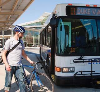
3 generate 255,000 additional daily trips, many of which will be made on local roadways. These trips will increase congestion during the highest AM and PM travel periods. Alternatives to the auto are needed to address the limited capacity of the corridor s roadway system to accommodate increased travel demand. Conventional buses tend to make frequent stops and operate in mixed traffic conditions, thereby slowing travel times and offering no travel time savings over the automobile. Sample trips (Table 3.3 in Section 3.2.2) illustrate what is problematic with much of the area s transit service: not only does transit fail to provide a travel time savings, but bus travel generally takes longer than auto travel due to less direct routing between key destinations, bus stops, and, in some cases, transfers. The sample trip between Chapel Hill and Durham, which has a total travel time of approximately one half hour by car, has a nearly 1 hour and 10 minute total travel time by bus on a typical weekday. On a weekend, that same trip by transit will take just over one and one half hours because of a longer walk to access to the bus due to the reduced frequency in CHT transit service. Need to expand transit options between Durham and Chapel Hill: Most bus service in the Durham Orange Corridor is concentrated in downtown Durham and downtown Chapel Hill. Transit connecting these urban centers and serving the residential areas and suburban style retail developments ES 3between them is limited to two Triangle Transit routes and the Duke University Robertson Scholars Express Bus. Currently, these buses operate in mixed traffic along increasingly congested roadways, have limited capacity, and are not competitive with the auto for most trips. Furthermore, the Study Area does not currently offer a high premium service for choice riders. Need to serve populations with high propensity for transit use: University students and employees, as well as transit dependent populations, are a significant percentage of the population in the D O Corridor. Expanding transit services and increasing access to each of the university campuses and medical centers, which offer pedestrian friendly environments, limited parking, and free transit passes, will support increased mobility options for university students, employees and other patrons. Also, expanding reliable mobility options for lower income populations and transit users who may not be able to drive will enhance economic opportunities through improved access to major jobs centers along the corridor. Providing a transit option that supports the mobility of these groups satisfies an important need within the corridor serving these communities. Need to foster compact development: Local governments recognize the need to manage growth and focus development within the Study Area. Durham City/County, Chapel Hill and Orange County have developed plans and implementation strategies that call for more compact, walkable, higher density, mixed use development within the D O Corridor. However, the existing transit infrastructure throughout the corridor is not fully supportive of these land use plans and implementation strategies and cannot facilitate long term economic development. A proposed fixed guideway transit investment can channel future growth, provide a superior transit option appropriate for high density development, and help local communities realize their goals and objectives for the future. Stakeholder and Public Involvement The project team consisted of Triangle Transit staff and the URS Corporation Consultant Team, with broad input from stakeholders and the general public through a multi faceted outreach program. The AA process included 19 public workshops, targeted communication with traditionally underserved groups, a public involvement steering committee, coordination with the two local MPOs and elected officials, and convening of working groups as necessary to review project alternatives. Outreach efforts Durham-Orange County Corridor Alternatives Analysis April 2012 ES-2
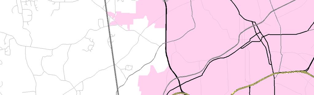
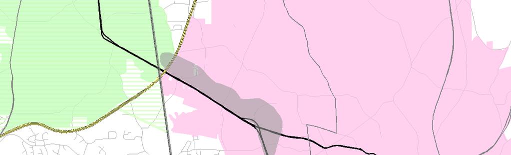
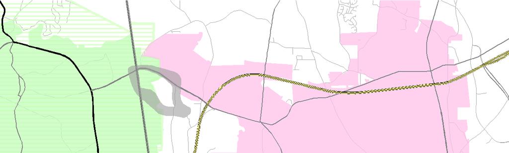
4 also included a project Web site ( a project hotline for telephone calls, a postal service mailing address, interior bus ads, news stories, a dedicated e mail account, and social media outlets. The comprehensive process yielded more than 1,100 public workshop attendees, several additional meetings with regional stakeholders, and receipt of over 500 comments through the various means of communication available. Tier 1 Screening: Conceptual Evaluation of Alternatives Methodology The conceptual evaluation focused on developing and evaluating transit technology alternatives and refining the transit alignment recommended in the US Phase I Major Investment Study (1998) and the US Phase II Major Investment Study (2001) and subsequently adopted by local governments. Screening criteria included assessment of potential transit ridership through the review of population and employment concentrations and suitability of transit mode; consistency with existing plans and studies; community support; presence of irresolvable environmental impacts; and technical and financial feasibility. Failure to meet at least one or more criterion resulted in elimination of an alternative from further consideration. The No Build and Transportation System Management (TSM) Alternatives, both required for inclusion by the FTA, were automatically advanced to the Detailed Evaluation of Alternatives. Transit Technology Evaluation Because a preferred transit technology was not selected through the course of the previous MIS studies, the project team developed four conceptual transit technology alternatives: Bus Rapid Transit (BRT), Streetcar, Light Rail Transit (LRT), and Commuter Rail (CRT). Streetcar was eliminated from further consideration because the mode would not sufficiently enhance mobility, increase transit efficiency, or improve transit connections throughout the project corridor. CRT was not advanced into the detailed evaluation of alternatives because it will not enhance mobility within the corridor as effectively as other transit technologies, is limited in the level of service provided to high need populations, and is cost prohibitive. BRT and LRT were found to be the most reasonable alternatives for the corridor that could address the project s Purpose and Need and were advanced for more detailed study. Alignment Evaluation The recommended transit alignment from the US Phase II Major Investment Study (MIS) was carried forward into the AA as the base alignment for all Build alternatives between UNC Hospitals and Duke Medical Center. Since completion of the US Phase II MIS, however, new development, transit technology considerations, and the availability of more detailed environmental information warranted consideration of alternate routes to specific segments of the base alignment. A total of 14 alignment alternatives, as shown in ES 1, were developed across the following five subareas within the Durham Orange Corridor Study Area: A. UNC Hospitals The UNC Hospitals area is the western terminus of the project corridor and is generally defined as the southern campus area between the UNC Hospitals, Manning Drive and Fordham Boulevard. Alternatives were conceptualized in this area to accommodate the possible future extension of the proposed transit system to the west through Chapel Hill and into Carrboro. B. Meadowmont The Meadowmont area is generally defined as the area along NC 54, from the US split to Friday Center Drive/Meadowmont Lane intersection. Several alternatives were conceptualized in this area due to several destinations including Meadowmont Subdivision, the Finley Golf Course, and the Friday Center. Durham-Orange County Corridor Alternatives Analysis April 2012 ES-3
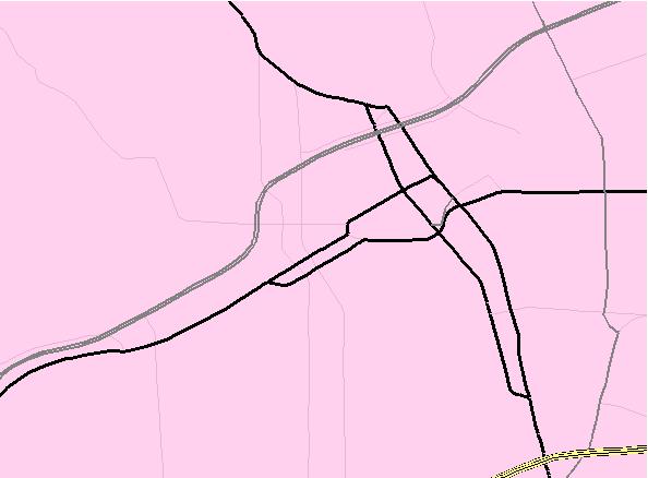
5 C. Leigh Village The Leigh Village area is generally defined as the area around NC 54, George King Road and Farrington Road. Several alternatives were conceptualized in this area due to the future development of the Leigh Village planned community, and potential impacts to wetlands associated with the water supply watershed of Lake Jordan. D. South Square The South Square area is generally defined as the area bordered by Westgate Drive, University Drive, Shannon Road, and Tower Boulevard. Alternatives were conceptualized in this area due to the complexity of accessing the South Square Shopping Center and crossing Durham Chapel Hill Boulevard. E. Downtown Durham The Downtown Durham area is the area between Duke Medical Center and Alston Avenue. An alternative was developed to study an alignment alternative off the existing rail right of way through downtown Durham. The alignment alternatives were narrowed to nine options which were advanced for study in Tier 2 of the screening process. More detailed information on the alignments options is presented in Section Tier 2 Screening: Detailed Evaluation of Alternatives Methodology The Detailed Evaluation of Alternatives focused on identifying the LPA to be advanced for further evaluation in the Preliminary Engineering/Environmental Impact Statement (PE/EIS) process. Alternatives were evaluated based on Ridership, Transportation Operations, Expansion Potential, Economic Development Potential, Public and Agency Support, and Environmental Impacts. Alternatives Considered In addition to the No Build and TSM Alternatives automatically advanced from the conceptual alternatives screening, the transit technologies and alignment options remaining after the conceptual alternatives were combined into three fixed guideway alternatives for detailed evaluation (Figure ES-1): LRT Alternative This alternative would operate light rail vehicles between University of North Carolina (UNC) Hospitals and east Durham and includes alignment options in UNC Chapel Hill (A1 UNC Hibbard Drive and A3 UNC Southern), Meadowmont/Woodmont (C1 Meadowmont Lane and C2 George King Road), and South Square (D1 Westgate Drive and D3 Shannon Road). A total of 17 station locations are proposed. BRT High Alternative This alternative would operate BRT between UNC Hospitals and east Durham, generally following the same alignment as LRT and including the same station locations. The only deviation would occur through downtown Durham to the end of line at Alston Avenue in east Durham where the BRT High option would utilize Pettigrew Street, while the LRT would run in the rail corridor. The BRT High would operate similar to conventional bus in mixed traffic along Pettigrew Street, but would transition to exclusive running along a new Pettigrew Street connection to be constructed as part of this project between Campus Drive and Duke Street. The new guideway connection between these intersections would require coordination with the operating railroads, NCDOT, Durham, and other stakeholders and, potentially require further engineering and design analysis. Durham-Orange County Corridor Alternatives Analysis April 2012 ES-4
6
7 BRT Low Alternative A second BRT alternative was developed to take advantage of the greater flexibility offered by BRT operations. The BRT Low Alternative alignment more closely follows existing roadways with less aerial structures and more mixed traffic segments. The BRT Low alignment is similar to the BRT High alignment but would deviate from the BRT High alignment in the following three segments: Hamilton Road to Leigh Village (BRT Low Alternative 1), Gateway to MLK Jr. Parkway (BRT Low Alternative 2), and Shannon Drive to Pickett Road (BRT Low Alternative 3). A total of 18 station locations are proposed. The summary of evaluation results focused first on narrowing down the alignment options under consideration and second on comparing and screening the Build Alternatives to arrive at a LPA recommendation. Alignment Evaluation. An evaluation of primary opportunities and constraints of the alignment options under consideration in the UNC Chapel Hill, Meadowmont/Woodmont, and South Square subareas resulted in the following preliminary alignment recommendations for each subarea: UNC Chapel Hill Alignment Option Recommendation: The project team recommended that alignment option A3 be carried forward as the preferred alignment option. Both the UNC and Town of Chapel Hill staff support this option. Meadowmont/Woodmont Alignment Option Recommendation: The project team recommended alignment option C1 be advanced as the preferred alignment option and also recommended advancing alignment option C2 through to the PE/NEPA phase in order to provide an opportunity for continued study of wetlands issues in the area. South Square Alignment Option Recommendation: The project team recommended alignment option D3 be advanced as the preferred alignment option. The potential for development for alignment option D3 and the surrounding land uses is, in the opinion of the project team, a very significant factor for the recommendation of D3 above and beyond the constraints cited. Build Alternatives Evaluation Results Incorporating the alignment recommendations into the Build Alternatives, the project team then evaluated each alternative against a set of detailed criteria. Table ES 1 summarizes the evaluation results. 1 A discussion of how well the alternatives performed relative to the project goals follows the table. Based on the information presented in Table ES 1, The BRT High and BRT Low Alternatives clearly rate well in their ability to meet the first three project goals. Both BRT Alternatives outperform the LRT Alternative in their ability to meet Goal 1: Improve mobility through and within the study corridor, Goal 2: Increase transit efficiency and quality of service, and Goal 3: Improve transit connections. The end toend travel time for the BRT Alternatives is slightly longer than the LRT Alternative; however, travel time does not seem to be a major differentiator with regard to passenger preference, as ridership on the BRT High and BRT Low Alternatives exceeds that of the LRT Alternative, even with a longer travel time. Additionally, while BRT Low would result in marginally worse traffic impacts than LRT and BRT High, traffic impacts is also not a major differentiator among the Build Alternatives. 1 Public and agency support is excluded from the summary table because of the limited amount of data available for evaluation. See Public and Agency Support under Section of this report for more information. Durham-Orange County Corridor Alternatives Analysis April 2012 ES-5
8 Table ES 1 Summary of Evaluation Results for LRT, BRT High, and BRT Low Alternatives Goals Evaluation Criteria* LRT BRT-High BRT-Low BRT route: 5,700** BRT route: 4,600** Ridership: Daily Project Interlined Buses: Interlined Buses: 12,000 Boardings 11,900 11,700 Total: 17,600 Total: 16,300 Goal 1: Improve mobility through and within the study corridor. Goal 2: Increase transit efficiency and quality of service. Goal 3: Improve transit connections. Goal 4: Support local and regional economic development and planned growth management initiatives Goal 5: Foster environmental stewardship Goal 6: Provide a costeffective transit investment. Ridership: System-wide Trips*** Transportation Operations: Traffic Impacts Transportation Operations: Travel Time Expansion Potential Public and Agency Support Economic Development Potential Environmental Impacts Estimated Cost (2011 $) Capital Estimated Cost (2011 $) O&M Cost (based on offered peak hour capacity of 800 and 1500 pax/hr ± ) 140, , , ,100 Low Low Moderate 35 minutes 39 minutes 44 minutes No engineering constraints & consistent with regional plans Could be inconsistent with regional connectivity goals Could be inconsistent with regional connectivity goals High Moderate Moderate Demonstrated ability to influence development Moderate property acquisitions, high visual impacts, moderate stream/wetland & construction impacts, no air quality impacts Unproven ability to influence development Moderate property acquisitions, visual impacts, stream/wetland & construction impacts, low air quality impacts Unproven ability to influence development High property acquisitions, low visual impacts, low stream/wetland impacts, moderate construction & low air quality impacts $1.37B $960M $810M 800 pax/hr: $14M 1500 pax/hr: $15M 800 pax/hr: $11M 1500 pax/hr: $13M 800 pax/hr: $11M 1500 pax/hr: $13M *Evaluation criteria include references to sections of the report where more information can be found. **Daily boardings for BRT High and BRT Low routes without interlined buses could potentially be higher as the model estimated the ridership assuming interlined buses. Interlining refers to the ability of local bus routes to use of the guideway in addition to the exclusive BRT service. The BRT numbers thus do not account for passengers that would transfer from feeder buses to BRT if the feeder buses were not sharing the BRT guideway ***System wide trips refer to total transit trips in the three county Triangle Region (Durham, Orange, and Wake Counties). ± passengers/hour Each of the three alternatives LRT, BRT High, and BRT Low also meet Goal 5: Foster environmental stewardship; however, the use of fossil fuels by buses makes LRT a more sustainable and desirable technology over the long term. And, while each would result in limited impacts to the natural and built environments, environmental impacts have not proven to be a major differentiator between the alternatives. From a cost perspective, the BRT High and BRT Low Alternatives best meet Goal 6: Provide a costeffective transit investment by providing a lower capital cost investment and O&M costs within the planning horizon for the proposed project. In terms of capital costs, while LRT presents substantially Durham-Orange County Corridor Alternatives Analysis April 2012 ES-6
9 higher costs than BRT, the cost of the LRT Alternative is still within the range of affordability as detailed in the separate Financial Plans being prepared for Durham, Orange, and Wake Counties. For O&M costs, decision makers must also consider that in the long term, the O&M costs of the BRT Alternatives will likely escalate higher than those of the LRT Alternative due to the shorter life span of buses compared to trains, operations (driver) costs, and, potentially, fuel costs. Ultimately the decision of whether BRT or LRT is a cost effective technology choice will depend largely on ridership. Currently, the BRT Alternatives do have slightly higher forecasted boardings but, as peak hourly volumes reach the range more comparable to existing LRT and BRT systems, LRT can meet the increased demand at a lower capital and O&M investment than BRT. While the BRT Alternatives are competitive regarding most project goals, the LRT Alternative clearly surpasses the BRT Alternatives under Goal 4: Support local and regional economic development and planned growth management initiatives. The LRT Alternative has demonstrated public support and a proven record of producing local and regional economic development benefits by enhancing and focusing growth within LRT corridors. LRT enhances opportunities for transit oriented development (TOD), and the resulting TOD can achieve rental rate premiums and higher land values over non light rail served properties. Impressive levels of development have been constructed along LRT lines in many examples across the nation. As evidenced by the dollars of investment with LRT corridors such as the Charlotte Blue Line, developers are interested in constructing transit oriented development at LRT stations, as they see the value in the transportation advantage afforded by LRT. Further, in support of planned growth management initiatives, LRT s proven ability to focus growth would, in the long run, have a more substantial impact on mobility because the land use impacts will result in more choices that can reduce impacts to the highway system. Build Alternative/Technology Recommendation: The ultimate choice of technology to carry forward is a major decision and could be considered a business decision beyond and above all else. Local and regional stakeholders place a high level of importance on economic development potential and focusing growth within the proposed transit corridor through TOD. LRT can bolster economic development and focus growth and the potential development dollars are not insignificant. The LRT Alternative alone can fully address the stated Purpose and Need for a fixed guideway investment in the Durham Orange Corridor; it can enhance mobility, expand transit options between Durham and Chapel Hill, serve populations with high propensity for transit use, and foster compact development. Therefore, the recommended Build Alternative (and technology) is the LRT Alternative. LPA Recommendation The Durham Orange Detailed Definition of Alternatives published in July 2011, for reasons presented in the preceding subsections recommended advancing the LRT Alternative as the LPA with alignment options A3, C1, and D3 and the associated station locations. It was also recommended that the alignment option C2 be carried forward for further study in the Preliminary Engineering / Draft Environmental Impact Statement (PE/DEIS) phase based on potential impacts to wetlands and US Army Corps of Engineers (USACE) owned property associated with the C1 Alternative. Figure ES 2 illustrates the LPA. Durham-Orange County Corridor Alternatives Analysis April 2012 ES-7
10 FIGURE ES-2 DURHAM-ORANGE RECOMMENDED LOCALLY PREFERRED ALTERNATIVE LEGEND Aerial Segment At-Grade Interstate Orange Co. Durham Co. 751 LaSalle Street 15 Duke Medical Center (A & B) Erwin Rd Ninth Street 147 Buchanan Boulevard Durham Dillard Street US Route NC Route Railroad County Boundary Town of Chapel Hill Chapel Hill ETJ 40 D3 South Square Alston Ave Alston Avenue!. City of Durham Expanded Study Area Conceptual Gateway Durham-Chapel Hill Blvd Patterson Place MLK Jr Parkway DURHAM N Miles 86 CHAPEL HILL Leigh Village 54 APRIL 2012 UNC Hospitals 54 A3 Hamilton Road (A & B) Mason Farm Road Meadowmont Lane Raleigh Rd Friday Center Drive (A & B) C1 C2 Woodmont Durham-Orange County Corridor Alternatives Analysis
11 Additional Evaluation and Endorsement of the LPA Since publication of the Detailed Evaluation of Alternatives and the recommended LPA in July, 2011, the public, Orange and Durham County Commissioners, Chapel Hill Town Council and Durham City Councils and the Durham Chapel Hill Carrboro Metropolitan Planning Organization (DCHC MPO) have held public hearings, reviewed and considered the recommended LPA. DCHC MPO, in conjunction with Triangle Transit, have held public workshops and received comments on the Detailed Definition of Alternatives which presented the recommended LPA (See Appendix C). Comments received were considered by local officials and the DCHC MPO prior to selection and adoption of the LPA. The events and activities relevant to the selection of the LPA are as follows: June 22, 2011: DCHC MPO approves Durham County Bus and Rail Investment Plan June 27, 2011: Durham Board of County Commissioners (BOCC) approves Durham County Bus and Rail Investment Plan August 29 30, 2011: DCHC Holds Public Workshops on Durham Orange Corridor AA November 8, 2011: Durham County holds successful referendum on ½ cent sales tax for transit January 11, 2012: DCHC MPO Conducts Public Hearing February 8, 2012: DCHC MPO Selects Locally Preferred Alternative. The recommended LPA was adopted with the modification that both the C1 and C2 alignment options be carried forward for further study in the Meadowmont and Woodmont station areas, with a preference for C2 (Figure ES 3). Final Alternatives Recommended for Study Based on this evaluation and the LPA adoption by the DCHC MPO on February 8, 2012, the final recommendations for alternatives to carry forward for study in the Draft Environmental Impact Statement are the No Build, Baseline/TSM (required by FTA for comparison to Build alternatives), and LRT between UNC Hospitals and Alston Avenue/NCCU, as follows: No Build Alternative. The No Build Alternative is used as a starting point to provide a comparison of all Build Alternatives in terms of costs, benefits, and impacts. The No Build Alternative includes all highway and transit facilities identified in the fiscally constrained 2035 Long Range Transportation Plan (LRTP), with the exception of the comprehensive system wide rail transit network, which includes the D O LRT Project. TSM Alternative. The primary purpose of the TSM Alternative is to develop an enhanced and robust bus network in the Durham Orange Corridor that provides a level of transit service and capacity roughly equivalent to that of a fixed guideway improvement. The TSM Alternative is required for inclusion in the DEIS by the FTA when federal funds are sought for capital improvements. The intention is to compare the efficiency and cost effectiveness of a significant bus network in the corridor with fixed guideway improvements to determine the impact on transit ridership, travel time, and other measures. LRT Build Alternative Locally Preferred Alternative. The alignment, which would be double tracked throughout, (one track for each direction of travel), would operate primarily at grade in a dedicated right of way parallel to existing roadways, with elevated sections throughout to mitigate potential traffic impacts or impacts to environmental features as needed. A total of 17 stations are proposed for the LRT Alternative. location refinements for stations such as Hamilton Road and Duke Medical Center will occur during the PE/EIS phase of the project, described in Section 6. During this phase, station layouts and designs will also be prepared. Durham-Orange County Corridor Alternatives Analysis April 2012 ES-8
12 FIGURE ES-3 DURHAM-ORANGE ADOPTED LOCALLY PREFERRED ALTERNATIVE LEGEND Aerial Segment At-Grade Routes to be studied further Interstate Orange Co. Durham Co. 751 LaSalle Street 15 Duke Medical Center (A & B) Erwin Rd Ninth Street 147 Buchanan Boulevard Durham Dillard Street US Route NC Route Railroad County Boundary 40 D3 Alston Ave Alston Avenue / NCCU Town of Chapel Hill South Square!. Chapel Hill ETJ City of Durham Expanded Study Area Conceptual Gateway Durham-Chapel Hill Blvd Patterson Place MLK Jr Parkway DURHAM N Miles 86 CHAPEL HILL Leigh Village 54 APRIL 2012 UNC Hospitals 54 A3 Hamilton Road (A & B) Mason Farm Road Meadowmont Lane Raleigh Rd Friday Center Drive (A & B) C1 C2 Woodmont Durham-Orange County Corridor Alternatives Analysis
13 The specific location of the LPA alignment is uncertain in two areas: 1. Crossing of Little Creek between Meadowmont Village and the proposed Leigh Village development: Alternatives C1 and C2 2. Crossing of New Hope Creek and Sandy Creek between Patterson Place and South Square: Alternative alignments generally south of Durham Chapel Boulevard. For the purposes of avoiding and minimizing impacts to sensitive environmental resources in these locations, practicable and reasonable alignment options in these locations will be studied in the DEIS. Next Steps The following is a description of the work that is currently underway and the next steps needed to advance the LPA through the overall project development and approval/implementation process and the resolution of known issues related to the LPA that will require further analysis and refinement. FTA Project Development Process. The LRT alternative has been officially selected by the DCHC MPO, and is contained in the region s financially constrained 2035 LRTP. The project team will prepare an application for entry into the FTA s New Starts process and request approval to begin the PE/EIS phase of the project development process. A decision from FTA regarding the entry of the D O LRT project into the New Starts funding program and authorization to commence the PE/EIS phase is anticipated to be received by mid Concurrent with the preparation of the New Starts application, scoping activities have been initiated for the environmental review process that is required by the National Environmental Policy Act of 1969 (NEPA). After receiving approval to enter New Starts, the project will move into the PE phase of project development. This approval by FTA signals that the project is eligible to be considered for future federal funding support. In the PE/EIS phase, more detailed design and engineering will be conducted to refine project costs and support preparation of an EIS. Following completion of PE and the EIS, Triangle Transit will request FTA permission to conduct Final Design. In Final Design, the engineering is completed, and negotiations, agreements and construction plans are finalized. As that work is being completed, Triangle Transit will work with FTA to negotiate a Full Funding Grant Agreement, which formally commits federal funding for the project. Issues for Further Analysis and Refinement Over the course of the AA, selection of the LPA, and leading up to scoping of the PE/EIS process, the following issues were identified for further analysis or coordination: Evaluation of project related environmental impacts and development of mitigation measures for unavoidable impacts. Study of alignment options in the US 15/501 Corridor between the proposed Patterson Place and MLK stations to avoid and minimize impacts to wetlands, streams, floodplains, ecologically sensitive resources, public lands and recreation areas associated with New Hope Creek and Sandy Creek. Further study of the C1 and C2 alignment options between Friday Center and Leigh Village to evaluate community impacts and to avoid and minimize impacts to wetlands, streams, Durham-Orange County Corridor Alternatives Analysis April 2012 ES-9
14 floodplains, ecologically sensitive resources, gamelands and federally owned lands associated with Little Creek. Refinement of station locations such as Hamilton Road, Patterson Place, Duke Medical Center. Development of station layouts and designs. Further evaluation of traffic and transportation impacts, particularly at LRT/street at grade crossings. Evaluation of possible rail operations and maintenance facility locations. Coordination and development of agreements with North Carolina Railroad (NCRR) and Norfolk Southern Railroad (NS) and North Carolina Department of Transportation as well as other state and local government agencies. Refinement of ridership estimates. Development of preliminary engineering drawings. Refinement of capital and operating and maintenance costs. Continued coordination with interested federal, state, and local government agencies Durham-Orange County Corridor Alternatives Analysis April 2012 ES-10
Durham-Orange Light Rail Transit Project
 Durham-Orange Light Rail Transit Project Scoping Information Booklet WHAT S INSIDE What is Scoping? p. 3 How was the LPA determined? p. 3 Project development process p. 4 Project Purpose & Need p. 5 Alternatives
U.S. Department of Transportation, Federal Transit Administration
 Durham-Orange Light Rail Transit Project Durham and Orange Counties, North Carolina Combined Final Environmental Impact Statement and Record of Decision Prepared pursuant to federal environmental laws,
Executive Summary October 2017
 Executive Summary The King of Prussia Rail Draft Environmental Impact Statement/Draft Section 4(f) Evaluation (DEIS) describes and summarizes the transportation and environmental benefits and impacts of
City of Brantford Chapter 3 TABLE OF CONTENTS
 Chapter 3 The Land Use & Transportation Connection TABLE OF CONTENTS 3.1 THE LAND USE & TRANSPORTATION LINK... 1 3.2 POPULATION & EMPLOYMENT GROWTH FORECASTS... 3 3.2.1 Proposed Places to Grow Plan Forecasts
METRA UP-W LINE. Locally Preferred Alternative Report
 METRA UP-W LINE Cook, Kane, and DuPage Counties Illinois Alternatives Analysis Study Document #9 Locally Preferred Alternative Report August 13, 2007 Prepared by Parsons Alternatives Analysis Documents
Fairfax County Countywide Transit Network Study
 Fairfax County Countywide Transit Network Study Proposed High Quality Transit Network Concept Metropolitan Washington Council of Governments Travel Forecasting Subcommittee September 20, 2013 1 Presentation
U.S. Department of Transportation Federal Transit Administration and Metropolitan Atlanta Rapid Transit Authority
 ATLANTA BELTLINE CITY OF ATLANTA, FULTON COUNTY, GA TIER 1 DRAFT ENVIRONMENTAL IMPACT STATEMENT/ SECTION 4(F) EVALUATION U.S. Department of Transportation Federal Transit Administration and Metropolitan
1.1 Purpose of the Project
 Chapter 1 Purpose and Need for East Link Project 1.1 Purpose of the Project The purpose of the East Link Project is to expand the Sound Transit Link light rail system from Seattle to Mercer Island, Bellevue
KNOXVILLE REGIONAL TRANSIT CORRIDOR STUDY
 KNOXVILLE REGIONAL TRANSIT CORRIDOR STUDY April 2013 Alignments Alignments Magnolia Ave Northeast corridor Knoxville Transit Center Hall of Fame Dr Magnolia Ave Prosser Rd. Corridor contains commercial,
Transit Service Guidelines
 G R E AT E R VA N CO U V E R T R A N S P O RTAT I O N A U T H O R I T Y Transit Service Guidelines PUBLIC SUMMARY REPORT JUNE 2004 Greater Vancouver Transportation Authority TRANSIT SERVICE GUIDELINES
1RUWKZHVW#:LFKLWD 0DMRU#,QYHVWPHQW#6WXG\
 1RUWKZHVW#:LFKLWD 0DMRU#,QYHVWPHQW#6WXG\ Executive Summary 3UHSDUHGýIRUã 3UHSDUHGýE\ã.DQVDVý'HSDUWPHQWýRI 7UDQVSRUWDWLRQ,QýDVVRFLDWLRQýZLWKã (DUWKý7HFKý,QFï EXECUTIVE SUMMARY Introduction This Northwest
Transit Oriented Development Study
 Federal Way Link Extension Transit Oriented Development Study Table of Contents Executive Summary ES 1 Chapter 1: Introduction.. 1-1 Chapter 2: Methodology. 2-1 Chapter 3: Project Overview 3-1 Chapter
Envisioning the Future: A History of Regional Planning Initiatives, Studies, and Plans
 Express Commuter Transit Travel Demand Management Regional Vanpool Program Regional Transportation Planning Piedmont Triad Regional Model Training and Education Convening and Cooperation Envisioning the
Northern Intermodal Transit Facility WHAT IS AN INTERMODAL TRANSIT FACILITY?
 WHAT IS AN INTERMODAL TRANSIT FACILITY? An intermodal transit facility gathers many modes of transportation together and is strategically located to increase destination alternatives. Intermodal facilities
Subarea Mobility Enhancements. 5.1 Transit and Pedestrian Improvements
 Section Five Section 5: Subarea Mobility Enhancements 5.1 Transit and Pedestrian Improvements From the outset of the master planning process, one of the primary goals was to integrate transit and pedestrian-oriented
Clifton Corridor Transit Initiative Project Development and NEPA. New Starts Assessment
 Clifton Corridor Transit Initiative Project Development and NEPA Phase 1 Environmental Review and Alternative Refinement Prepared for: Metropolitan Atlanta Rapid Transit Authority Prepared by: AECOM/JACOBS-JJG
South Sounder Capital Improvements Program
 South Sounder Capital Improvements Program Subarea South King/Pierce Primary Mode Commuter Rail Facility Type Infrastructure Improvement Length Version Draft ST3 Plan Date Last Modified March 28, 2016
Memorandum. FROM: Jim Ortbal Rosalynn Hughey Barry Ng TO: HONORABLE MAYOR, CITY COUNCIL. DATE: June 16, 2017
 CITY OF SANjOSE CAPITAL OF SILICON VALLEY TO: HONORABLE MAYOR, CITY COUNCIL SUBJECT: TRANSPORTATION POLICY UPDATE REQUIRED BY STATE LAW - LOS TO VMT Memorandum FROM: Jim Ortbal Rosalynn Hughey Barry Ng
S-09: Auburn Station Access Improvements
 Project Number S-09 Subarea South King Primary Mode Commuter Rail Facility Type Infrastructure Improvements Length Version Number ST Board Workshop Date Last Modified 11-25-2015 PROJECT AREA AND REPRESENTATIVE
APPENDIX H: TRAVEL DEMAND MODEL VALIDATION AND ANALYSIS
 APPENDIX H: TRAVEL DEMAND MODEL VALIDATION AND ANALYSIS Travel demand models (TDM) simulate current travel conditions and forecast future travel patterns and conditions based on planned system improvements
LOCALLY PREFERRED ALTERNATIVE REPORT
 SOUTHEAST CORRIDOR ALTERNATIVES ANALYSIS DOCUMENT #9 LOCALLY PREFERRED ALTERNATIVE REPORT PREPARED BY AUGUST 2011 ALTERNATIVES ANALYSIS DOCUMENTS 1. Detailed Work Scope 2. Purpose & Need 3. Initial Alternatives,
Transit, Intercity Bus, Taxi 8-1
 8-1 Introduction Public transit is a critical element of any transportation system. It both provides an alternative form of transportation to the traditional use of the automobile and provides mobility
Future System Planning (ST4)
") Future System Planning (ST4) Subarea All Primary Mode Policies and Programs Facility Type Length Version Draft ST3 Plan Date Last Modified March 28, 2016 PROJECT AREA AND REPRESENTATIVE ALIGNMENT SHORT
Future System Planning (ST4) Subarea All Primary Mode Policies and Programs Facility Type Length Version Draft ST3 Plan Date Last Modified March 28, 2016 PROJECT AREA AND REPRESENTATIVE ALIGNMENT SHORT
Bonnie Doon Grade Separation
 6. 2 Bonnie Doon Grade Separation Recommendation: That the April 18, 2017, Integrated Infrastructure Services report CR_4461, be received for information. Report Summary This report provides information
Scope of Work. Project Approach and Understanding. Task 1: Study Initiation and Administration
 Scope of Work Route 116/Hinesburg Growth Center Corridor Study Town of Hinesburg and CCRPC Project Approach and Understanding Route 116 through Hinesburg had seen substantial changes in the past 15 years,
ARLINGTON COUNTY TRANSIT DEVELOPMENT PLAN
 p EXECUTIVE SUMMARY Report Prepared by: ARLINGTON COUNTY TRANSIT DEVELOPMENT PLAN The Arlington County Transit Development Plan (TDP) is an effort to evaluate and assess the performance, connectivity,
CAPITAL AREA TRANSIT PLANNING SERVICE STANDARDS AND PROCESS. Planning Department
 CAPITAL AREA TRANSIT PLANNING SERVICE STANDARDS AND PROCESS Planning Department January 2016 INTRODUCTION Transit Service Standards are public rules and guidelines used to make decisions about where transit
LAS VEGAS STREET RAILROAD CROSSING RR/PUC CONNECTION AND PRELIMINARY DESIGN
 LAS VEGAS STREET RAILROAD CROSSING RR/PUC CONNECTION AND PRELIMINARY DESIGN Prepared for: City of Colorado Springs Prepared by: Felsburg Holt & Ullevig 508 South Tejon Street Colorado Springs, CO 80903
TRANSIT SERVICE GUIDELINES
 CHATHAM AREA TRANSIT AUTHORITY FEBRUARY 2014 Table of Contents 1. PURPOSE... 3 2. CAT SERVICE GUIDELINES... 3 3. TRAVEL MARKETS... 4 4. TRANSIT COVERAGE... 4 5. TRANSIT ACCESS... 4 6. BUS STOP SPACING
2. OMNITRANS SYSTEM. 2.3 Omnitrans Services. 2.1 Background. 2.4 Traditional Fixed Route Service. 2.2 Omnitrans Mission TRANSIT DESIGN GUIDELINES
 2. OMNITRANS SYSTEM 2.1 Background Omnitrans was founded in 1976 under a Joint Powers Agreement to provide public transportation service to the San Bernardino Valley. Omnitrans is the major public transportation
Notice of Preparation For Link Union Station (Link US) Project. Joint Environmental Impact Statement and Environmental Impact Report
 Project. Joint Environmental Impact Statement and Environmental Impact Report") Notice of Preparation For Link Union Station (Link US) Project Joint Environmental Impact Statement and Environmental Impact Report Date: May 27, 2016 To: Subject: Project Title: From: All Interested Agencies,
Notice of Preparation For Link Union Station (Link US) Project Joint Environmental Impact Statement and Environmental Impact Report Date: May 27, 2016 To: Subject: Project Title: From: All Interested Agencies,
APPENDIX D: Public Comments. Durham-Orange Light Rail Transit Project
 APPENDIX D: Public Comments Durham-Orange Light Rail Transit Project December 2016 Appendix D: Public Comments Appendix D: Public Comments ID Name Date 1 Mary Brinson November 12, 2016 2 Don Moffit November
NEW OPPORTUNITY FOR MIDDLESEX COUNTY
 Source: http://www.flickr.com/photos/scraparcs/3259040067/sizes/l/in/photostream/ RARITAN RIVER LIGHT RAIL NEW OPPORTUNITY FOR MIDDLESEX COUNTY This report studies the viability of a new transit line connecting
9 Before and After Study Plan
 9 Before and After Study Plan A Before and After Study Plan has been prepared, describing how the Massachusetts Bay Transportation Authority (MBTA), in cooperation with the Massachusetts Department of
2. What is the genesis of the KOP Rail project? How long has this been studied?
 These frequently asked questions (FAQ) have been developed to help residents, businesses and area stakeholders develop a better understanding of the proposed King of Prussia Rail Project, the project development
Sounder Extension to DuPont
 Subarea Pierce Primary Mode Commuter Rail Facility Type Station Length 7.8 miles Version Draft ST3 Plan Date Last Modified March 28, 2016 PROJECT AREA AND REPRESENTATIVE ALIGNMENT SHORT PROJECT DESCRIPTION
AMPO Annual Conference Session: Performance (Part 1) October 18, 2017 Savannah, GA
 October 18, 2017 Savannah, GA") AMPO Annual Conference Session: Performance (Part 1) October 18, 2017 Savannah, GA Introduction: North Jersey Transportation Planning Authority NJTPA Congestion Management Process Study Goals Analysis
AMPO Annual Conference Session: Performance (Part 1) October 18, 2017 Savannah, GA Introduction: North Jersey Transportation Planning Authority NJTPA Congestion Management Process Study Goals Analysis
6.0 Indirect Effects and Cumulative Impacts
 6.0 Effects and Impacts 6.1 Introduction This chapter of the Draft EIS addresses potential indirect and cumulative impacts of the Bottineau Transitway project. effects are those that are caused by the
Sustainability. Sustainability Principles. 1. Framework. Spokane Transit s definition of Sustainability is:
 Sustainability Spokane Transit s definition of Sustainability is: Sustainability at Spokane Transit is about providing services in ways that optimize our ability to meet the needs of present and future
Chapter 2: Alternatives
 Chapter 2: Alternatives Introduction An Environmental Impact Statement (EIS) is a procedural document. In other words, the environmental planning process follows a logical sequence of development. Subsequent
Regional Transportation Studies Regional Council
 Pima Association of Governments 1 E. Broadway, Tucson, Arizona Santa Rita Conference Room Regional Transportation Studies Regional Council September 28, 2017 I-11 Tier 1 Environmental Impact Statement
Purpose of the Countywide Transportation Plan SAN FRANCISCO COUNTY TRANSPORTATION AUTHORITY
 > 12 Purpose of the Countywide Transportation Plan SAN FRANCISCO COUNTY TRANSPORTATION AUTHORITY 13 SAN FRANCISCO S MULTIMODAL transportation network is crucial to San Francisco s status as a major regional
2 Purpose and Need. 2.1 Study Area. I-81 Corridor Improvement Study Tier 1 Draft Environmental Impact Statement
 2 Purpose and Need 2.1 Study Area Interstate 81 (I-81) is relied upon for local and regional travel and interstate travel in the eastern United States. It extends 855 miles from Tennessee to New York at
HORIZON 2030: Plan Projects November 2005
 Horizon PROJECTS 2030 Projects 10-1 10-2 The Horizon 2030 Project Information section is comprised of individual project information in alphabetical order by project name. The information provided for
AIR QUALITY AND CLIMATE CHANGE EVALUATION GUIDANCE
 AIR QUALITY AND CLIMATE CHANGE EVALUATION GUIDANCE The following guidance provides additional details regarding the process followed by PSRC to evaluate projects for potential air quality benefits. As
November 8, RE: Harrah s Station Square Casino Transportation Analysis Detailed Traffic Impact Study Review. Dear Mr. Rowe:
 November 8, 2006 Mr. Glenn Rowe, P.E. Pennsylvania Department of Transportation Bureau of Highway Safety and Traffic Engineering Commonwealth Keystone Building 400 North Street, 6 th Floor Harrisburg,
Identification and Evaluation of Alternatives Tier 1
 Vanasse Hangen Brustlin, Inc. DRAFT 4 Identification and Evaluation of Alternatives Tier This chapter describes the initial set of alternatives that were identified to address the Purpose and Need of the
Project Overview. A Collaborative Effort
 Project Overview A Collaborative Effort DRPT and FRA are working closely with CSX, which owns and operates the corridor, as well as with passenger operators Amtrak and Virginia Railway Express (VRE), the
South Florida East Coast Corridor (SFECC) Study
 Study") South Florida East Coast Corridor (SFECC) Study P r o j e c t U p d a t e J u l y 2 7, 2 0 11 FM Number: 417031-3-22-01 Re-introduce Passenger Rail Service on FEC Corridor (85 miles) Improve Freight Capacity
South Florida East Coast Corridor (SFECC) Study P r o j e c t U p d a t e J u l y 2 7, 2 0 11 FM Number: 417031-3-22-01 Re-introduce Passenger Rail Service on FEC Corridor (85 miles) Improve Freight Capacity
Fairmount Line Feasibility Study
 Executive Summary Wednesday October 16, 2002 Prepared for Massachusetts Bay Transportation Authority Planning Department Prepared by KKO and Associates, L.L.C. Two Dundee Park Andover, Massachusetts 01810
2040 Transportation Policy Plan Conversion to Performance Based Planning Basis. 25 th Annual CTS Transportation Research Conference May 21, 2014
 2040 Transportation Policy Plan Conversion to Performance Based Planning Basis 25 th Annual CTS Transportation Research Conference May 21, 2014 1 About the plan Long-range transportation plan for the Twin
VISION. 4. Vision. 31 Page
 VISION 4. Vision The 2035 LRTP, branded as Transformation, is the Broward MPO s plan for change. Economic vitality for the region, a better environment, and enhanced quality of life are envisioned. This
ORLANDO INTERNATIONAL AIRPORT (OIA) CONNECTOR REFRESH ALTERNATIVES ANALYSIS FINAL REPORT
 CONNECTOR REFRESH ALTERNATIVES ANALYSIS FINAL REPORT") ORLANDO INTERNATIONAL AIRPORT (OIA) CONNECTOR REFRESH ALTERNATIVES ANALYSIS FINAL REPORT Prepared For: Florida Department of Transportation, District Five Prepared By: HDR Engineering, Inc. February 2016
ORLANDO INTERNATIONAL AIRPORT (OIA) CONNECTOR REFRESH ALTERNATIVES ANALYSIS FINAL REPORT Prepared For: Florida Department of Transportation, District Five Prepared By: HDR Engineering, Inc. February 2016
CUY-90-Innerbelt ODOT PID No 77510
 CUY-90-Innerbelt ODOT PID No 77510 Chapter 1: Project History and Background Figure 1-1: Innerbelt Study Area Points of Interest 1.0 Introduction Planned in the 1940s and built during the 1950s and early
SERVICE IMPROVEMENT STRATEGIES AND SCENARIOS
 SERVICE IMPROVEMENT STRATEGIES AND SCENARIOS The Hartford region has seen significant improvements in terms of intermodal connectivity and mode choice. Recent investments include the new CTfastrak bus
GO RAIL NIAGARA SERVICE EXTENSION
 Business Case: Finch Avenue West Rapid Transit GO RAIL NIAGARA SERVICE EXTENSION INITIAL BUSINESS CASE Date: November, 2014 NOVEMBER 2015 Page 1 TABLE OF CONTENTS 1.0 Executive Summary...p.5 2.0 Introduction....p.6
PUBLIC HEARING April 24, 2017
 PUBLIC HEARING April 24, 2017 1 Agenda SDEIS Public Review Environmental Process Overview Project Highlights Comments to Stenographer 2 3 SDEIS Public Review Public Hearing Schedule Monday, April 24, 2017
Jim Alexander Director of Design and Engineering, Southwest Light Rail Transit Project
 Memorandum Date: January 15, 2014 To: CC: From: Subject: Jim Alexander Director of Design and Engineering, Southwest Light Rail Transit Project Paul Danielson, P.E. Project Manager, Southwest Light Rail
Rapid Transit in Winnipeg. Winnipeg TOD Summit November 17, 2014
 Rapid Transit in Winnipeg Winnipeg TOD Summit November 17, 2014 Presentation Overview Rapid Transit (RT) in Winnipeg What is RT? What are our RT plans? Near term Longer term Comments re: TOD OurWinnipeg
 EXHIBIT 3 CORRESPONDENCE 1 8/15/16 BCT Broward Next Policy Concept EXHIBIT A Legend Qualified Transit Areas Areas highlighted in orange are within 0.5 miles of a rail station or 0.25 miles of a bus
Appendix D: Functional Classification Criteria and Characteristics, and MnDOT Access Guidance
 APPENDICES Appendix D: Functional Classification Criteria and Characteristics, and MnDOT Access Guidance D.1 Functional classification identifies the role a highway or street plays in the transportation
LUNDY S LANE COMMUNITY IMPROVEMENT PLAN STUDY
 PUBLIC INFORMATION MEETING # October, 0 LUNDY S LANE COMMUNITY IMPROVEMENT PLAN STUDY AGENDA :00 to :0pm: Open House :0 to :pm: Presentation : to :00pm: Individual paced workshop with the Study Team PUBLIC
Greenhouse Gas Emission Reduction Strategies
 Greenhouse Gas Emission Reduction Strategies 2011 ITE Quad Conference April 18 19, 2011, Embassy Suites; Lynnwood, WA Victor L. Sl Salemann, PE Senior Associate David Evans and Associates Bellevue, WA
AGENDA COMMITTEE OF THE WHOLE COUNTY OF KANE
 AGENDA COMMITTEE OF THE WHOLE COUNTY OF KANE Tuesday, April 30, 2013 4:00 p.m. County Board Room Bldg. A A. CALL TO ORDER B. ROLL CALL C. PLEDGE OF ALLEGIANCE & PRAYER D. APPROVAL OF MINUTES: March 26,
TransAction Plan Draft for Public Comment Spring/Summer 2017
 Transportation Action Plan for Northern Virginia TransAction Plan Draft for Public Comment Spring/Summer 2017 Comments are invited on this TransAction Plan, and associated TransAction Plan Project List.
Trips on project forecasting How STOPS works Making STOPS work for you Experience thus far with STOPS applications
 STOPS presented to MTF Transit and Rail Committee presented by Jim Ryan, FTA Bill Woodford, RSG March 25, 2014 Parts of the Presentation Trips on project forecasting How STOPS works Making STOPS work for
Fixed Guideway Transit: An Estimate of Probable Costs
 Fixed Guideway Transit: An Estimate of Probable Costs Fixed Guideway transit includes services such as Bus Rapid Transit, Light Rail, and Modern Streetcar. The range of costs for the Fixed Guideway systems
This page intentionally left blank.
 EXECUTIVE SUMMARY This page intentionally left blank. SATOMORROW MULTIMODAL TRANSPORTATION PLAN EXECUTIVE SUMMARY Introduction The City of San Antonio is anticipated to experience tremendous growth resulting
Interchange Workshop Report (August 2004)
") U.S. Highway 14 Corridor Study New Ulm to North Mankato Table of Contents Section Interchange Workshop Report (August 2004) Page 1. Introduction and Next Steps 1 2. Interchange Workshop Participants &
U.S. Highway 14 Corridor Study New Ulm to North Mankato Table of Contents Section Interchange Workshop Report (August 2004) Page 1. Introduction and Next Steps 1 2. Interchange Workshop Participants &
Project Steering Committee April 14, 2015
 Project Steering Committee April 14, 2015 Agenda Project Background and Schedule Agency Coordination Project Need and Purpose Alternatives Under Consideration Resources Stakeholder and Public Involvement
FUTURE BUS RAPID TRANSIT PLANS
 ATTACHMENT 1 Preferred Configuration Saskatoon Bus Rapid Transit - Preferred Configuration FUTURE BUS RAPID TRANSIT PLANS Plan For Growth Transportation Plan BRT Plan October 2017 saskatoon.ca/engage 1
CHAPTER 1: INTRODUCTION/ GOALS AND OBJECTIVES
 CHAPTER 1: INTRODUCTION/ GOALS AND OBJECTIVES 1.1: INTRODUCTION ABOUT THE FREDERICKSBURG AREA METROPOLITAN PLANNING ORGANIZATION (FAMPO) Established in 1992, the Fredericksburg Area Metropolitan Planning
TRANSPORTATION 101 Today and Tomorrow. Moving People and Goods
 TRANSPORTATION 101 Today and Tomorrow Moving People and Goods What is the Transportation Commission? An independent, seven-member body of citizens appointed by the Governor for six-year terms and representing
NEW ORLEANS REGION TRANSIT COMPREHENSIVE OPERATIONS ANALYSIS SCOPE OF SERVICES. RPC Project LA90X361
 NEW ORLEANS REGION TRANSIT COMPREHENSIVE OPERATIONS ANALYSIS SCOPE OF SERVICES RPC Project LA90X361 Overview Summary The purpose of the Comprehensive Operations Analysis (COA) is to provide detailed review
1.0 PURPOSE AND NEED
 1.0 PURPOSE AND NEED This chapter documents the need for transit improvements in the Northwest Corridor and the purposes that the proposed action (Build Alternative) is intended to serve. An overview of
Land Use Assumptions and the Plan Development Process
 Land Use Assumptions and the Plan Development Process Regional Transportation Plan 2030 115 Regional Transportation Plan 2030 116 Land Use Assumptions and the Plan Development Process Travel demand is
407 TRANSITWAY. Planning & Preliminary Design
 FROM EAST OF HIGHWAY 400 TO KENNEDY ROAD GWP #252-96-00 Public Information Centre #2 June 24 th and 29 th, 2010 Purpose of Public Information Centre #2 The first Public Information Centre (PIC #1) was
THE REGION S PLAN POLICY FRAMEWORK. August 2015
 THE REGION S PLAN POLICY FRAMEWORK August 2015 2 What is The Policy Framework? Cover photo credit: Sinan Sinharoy for Atlanta BeltLine, Inc. Atlanta is one of the world s most dynamic metropolitan areas,
DART s Role in Transit - Oriented Development. Jack Wierzenski,, Director Economic Development & Planning Dallas Area Rapid Transit
 DART s Role in Transit - Oriented Development Jack Wierzenski,, Director Economic Development & Planning Dallas Area Rapid Transit The DART System Established in 1983 13 Member Cities Local Funding: $.01
APPENDIX B. Public Works and Development Engineering Services Division Guidelines for Traffic Impact Studies
 APPENDIX B Public Works and Development Engineering Services Division Guidelines for Traffic Impact Studies Revised December 7, 2010 via Resolution # 100991 Reformatted March 18, 2011 TABLE OF CONTENTS
State Route 8 Bridge Replacement Project
 OPEN HOUSE PUBLIC INVOLVEMENT MEETING Celebration Church 688 Dan Street, Akron, Ohio Tuesday, July 14, 2015 5:00 PM to 7:00 PM State Route 8 Bridge Replacement Project Existing Bridge Future Bridges: Steel
Miami-Dade Transit. Alice N. Bravo, P.E. Director. Miami-Dade Transit 1
 Miami-Dade Transit Alice N. Bravo, P.E. Director Miami-Dade Transit 1 Miami-Dade Transit MDT is the largest transit agency in the State of Florida, and one of the largest departments within Miami-Dade
The Folded Interchange: An Unconventional Design for the Reconstruction of Cloverleaf Interchanges
 The Folded Interchange: An Unconventional Design for the Reconstruction of Cloverleaf Interchanges I. ABSTRACT Keith A. Riniker, PE, PTOE This paper presents the Folded Interchange design and compares
High-Speed Rail - Chicago to St. Louis Alton Regional Multimodal Transportation Center Project
 High-Speed Rail - Chicago to St. Louis Alton Regional Multimodal May 2012 Draft Report: Alternatives Screening Version 1.0 1.0 Introduction This document outlines the alternatives screening process used
ISSUES & RISKS Potential timing and coordination with a future system planning process Coordination with jurisdictions and partner transit agencies
 Subarea Systemwide Primary Mode HCT Facility Type Study Length Date Last Modified July 1, 2016 PROJECT AREA AND REPRESENTATIVE ALIGNMENT SHORT PROJECT DESCRIPTION The planning studies will help to identify
SPACE COAST TRANSPORTATION PLANNING ORGANIZATION
 SPACE COAST TRANSPORTATION PLANNING ORGANIZATION DRAFT AUGUST 2015 This page intentionally left blank SPACE COAST TRANSPORTATION PLANNING ORGANIZATION DRAFT AUGUST 2015 prepared by: This page intentionally
BOSTON REGION METROPOLITAN PLANNING ORGANIZATION
 PLANNING ORGANIZATIO BOSTON REGION MPO NMETROPOLITAN BOSTON REGION METROPOLITAN PLANNING ORGANIZATION Stephanie Pollack, MassDOT Secretary and CEO and MPO Chair Karl H. Quackenbush, Executive Director,
May April 2016 DRAFT. London s Rapid Transit Initiative. Business Case
 May April 2016 London s Rapid Transit Initiative Business Case DRAFT Table of Contents EXECUTIVE SUMMARY...i Economic Environmental Scan iii Key Benefits of London s Rapid Transit Initiative iii Plan
1.1.1.b. Agencies share best practices as they integrate COMPASS facilitates
 Transportation Goals 1.1 Enhance the system to improve accessibility and connectivity to jobs, schools, and services; allow the efficient movement of people and goods; and ensure the reliability of travel
SR 417 Extension. June 2003 INTRODUCTION AND HISTORY PROJECT SCOPE AND PURPOSE STUDY OBJECTIVE STUDY PHASES
 Planning Feasibility Study June 2003 INTRODUCTION AND HISTORY The SR 417 Extension Study was a yearlong effort undertaken by Florida s Turnpike Enterprise to investigate the feasibility of a new toll road
I-70 East ROD 1: Phase 1 (Central 70 Project) Air Quality Conformity Technical Report
 Air Quality Conformity Technical Report") I-70 East ROD 1: Air Quality Conformity Technical Report January 2017 I-70 East ROD 1: Air Quality Conformity Technical Report TABLE OF CONTENTS Chapter Page 1 PURPOSE OF THIS REPORT... 1 2 PROJECT DESCRIPTION...
I-70 East ROD 1: Air Quality Conformity Technical Report January 2017 I-70 East ROD 1: Air Quality Conformity Technical Report TABLE OF CONTENTS Chapter Page 1 PURPOSE OF THIS REPORT... 1 2 PROJECT DESCRIPTION...
Exposition Light Rail Transit Project
 Exposition Light Rail Transit Project Expo Project Briefing Phase 1 and 2 For IRWA October 26, 2010 Phase 1 Phase 1 Project Description Phase 1 from Downtown Los Angeles to Culver City: 8.6 mile corridor
Ottawa Transportation Master Plan 2013
 Introduction Ottawa s 2013 Transportation Master Plan (TMP) update sets a new standard for sustainable transportation planning in Canada. The plan, unanimously approved by Ottawa City Council, sets forward
MONITORING IMPLEMENTATION AND PERFORMANCE
 12 MONITORING IMPLEMENTATION AND PERFORMANCE The FAST Act continues the legislation authorized under MAP-21, which created a data-driven, performance-based multimodal program to address the many challenges
RER New Stations Initial Business Case BRESLAU STATION. Kitchener Corridor. July Draft
 RER New Stations Initial Business Case BRESLAU STATION Kitchener Corridor July 2016 Draft Draft: v1.2 Metrolinx RER New Stations Initial Business Case BRESLAU Draft Prepared by: IBI Group 55 St. Clair
PUBLIC TRANSPORTATION PLAN
 PUBLIC TRANSPORTATION PLAN Introduction Public transportation is a vital element of the total transportation services provided within a metropolitan area. Not only does public transportation provide options
6.2.2 Environmental Consequences and Mitigation Measures
 6.2 6.2.1 Introduction The existing conditions, regulatory setting, and methods of analysis for transportation under CEQA are described in Chapter 3, NEPA and CEQA Analysis. Impacts that would result from
Transportation Report to SPC on Transportation and Transit 2017 March 15. ISC: UNRESTRICTED TT Page 1 of 7 ROUTEAHEAD UPDATE
 Page 1 of 7 EXECUTIVE SUMMARY This report provides Council with an update on the status of implementation of RouteAhead, a 30-year strategic plan for public transit in Calgary. The report also highlights
Staff Priority and UPWP Committee Priority List 3/25/2016. ID Proposed Study Name Project Category Tentative Project Cost
 Staff and UPWP Committee List 3/25/2016 Projects with Only (No Bottom Non- ) C-2 Safety and Operations at Selected Intersections: FFY 2017 Roadway Network Performance $65,000 Purpose: The purpose of this
Utah s Most Critical Surface Transportation Projects to Support Economic Growth and Quality of Life. March Washington, DC
 Utah s Most Critical Surface Transportation Projects to Support Economic Growth and Quality of Life March 2015 Washington, DC 202-466-6706 Founded in 1971, TRIP of Washington, DC, is a nonprofit organization