Watershed Characterization, Monitoring and Measurements
|
|
|
- Vernon Jefferson
- 6 years ago
- Views:
Transcription
1 Watershed Characterization, Monitoring and Measurements Intent - highlight key approaches to watershed monitoring using the Fair Hill Study watershed as an example Watershed characterization and monitoring will be essentially driven by the key question that you are trying to address - Understanding watershed mechanisms or solving specific environmental problems Long-term Short-term Intensive and focused Spatially distributed Level of funding
 Geology bedrock type Forest / Vegetation type, age, etc Landuse and landcover and history Soil type and")
2 Basic watershed characteristics that you need to know Climate, physiographic region, ecoregion Size of watershed, scale, stream order and other geomorphic attributes Topography elevation, aspect, slopes use of a digital elevation model (DEM) Geology bedrock type Forest / Vegetation type, age, etc Landuse and landcover and history Soil type and variability

3 N Now Meters 1877
4 Spatial GIS data can especially helpful in characterizing watershed features. Data like DEMs can help characterize additional watershed features such as the topographic index that can provide additional insights into hydrology, moisture distribution and potential for biogeochemical activity in the catchment. This information can also help you determine where you need to place your instruments or sampling devices. GIS maps.. N Meters
5 % slope - from 2 m LIDAR slope No Data Aspect of selcdem Flat (-1) North (0-22.5, ) Northeast ( ) East ( ) Southeast ( ) South ( ) Southwest ( ) West ( ) Northwest ( ) No Data aspect


6 Mt. Cuba Wissahickon formation undivided Pelitic gneiss and pelitic schist with subordinate amphibolite and pegmatite. The predominant lithology is quartz plagioclase biotite muscovite gneiss, with or without sillimanite and small garnets

7 GaD GgB MaD MaB GeA BaA GeC GeB Hw BbB BaA Baille silt loam GaD Gaila loam GeA Glenelg loam Etc. MaC Selstrm.shp Soils78ha.shp BaA BbB GaD GeA GeB GeC GgB Hw MaB MaC MaD Soil characterization, sampling, and analysis done at multiple locations Soils SSURGO Map for the Fairhill watershed Soil pits or augers can be used.

8 tidwi No Data Topographic Index Map for the Fairhill catchment Derived from the 2m LIDAR DEM. On the left is the full 79 ha catchment while on the right is the 12 ha catchment.
, and Acer rubrum")
9 Dominant Trees - Fagus grandifolia (American beech), Liriodendron tulipifera (yellow poplar), and Acer rubrum (red maple)
10 Why do we need to all these features how does it influence watershed hydrochemistry?? Answer -???? Should also investigate the inter-relationships between these watershed attributes. The wetness or moisture distribution in the catchment may have implications for soil formation and vegetative/tree species and vice-versa!


11 Watershed Hydrologic Monitoring Weather parameters using a climate station Precipitation tipping bucket Snowfall amounts and melt snow pillow Air temperature - thermometer Humidity humidity sensor Wind speed - anemometer Wind direction direction sensor Solar radiation radiation sensor Basic data precipitation, daily air temps, solar radiation. Delaware real-time weather data for watersheds -

12 Streamflow runoff is measured by Flumes Weirs Natural channel with rating curves Need to measure depth of water and/or velocity Depth pressure transducers Velocity radar sensors Basic data streamflow discharge

13
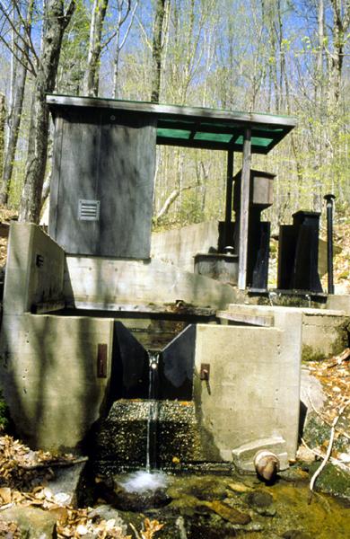
14

15 Water level stage recorder courtesy Myron Mitchell
16 Frequency of measurements dictated by the rate of which the water level changes dictated by the size of the watershed and the types of storm events. Depth of flow is converted into discharge Q (liters/sec), m 3 /s, m 3 /day using a calibrated equation provided by flume manufacturer Can also be expressed as depth = mm/hr or mm/day (by dividing volumetric mass of water by the catchment area) this is compared against the rainfall input to generate runoff ratio.


17 Soil moisture (in-situ measurements) Measured using Time Domain Reflectometry (TDR) instruments The transmission of the electromagnetic wave is a function of the dielectric properties and the moisture content of the soil. E.g., - the theta probe provides volumetric moisture content once calibrated. Local point readings not hillslope or watershed scale patterns Basic data soil moisture and temperature

18 Bloom and Meerveld, 2015

19 Bloom and Meerveld, 2015

20 Bloom and Meerveld, 2015

21 Harvey and Gooseff, 2015
22 Groundwater elevations and head using Groundwater elevations measured using a fully screened well. Elevation can be used to determine the subsurface flux or potential for soil moisture/saturation. Land Surface Elevation Stickup Depth to water Screen
23
24 Groundwater heads can be determined using piezometers. Piezometers wells which are only screened at the point of interest provide the hydraulic head at that point. Hi Flow Path \ Low Total head = elevation + hydraulic head The total head between two piezometers can help determine the direction of flow.
25 Don Siegel s graphics Stagnant! Or towards or away from you! A B C A B C A B C Peizometers at different locations ABC AB C AB C Peizometers at different depths Use of 3 GW wells or peizometers can provide you an initial idea of GW flow
26 Water Chemistry Monitoring and Sampling Rainfall or throughfall performed to get an estimate of atmospheric input or deposition Rainfall or throughfall collectors. Recovered after rain events. National Atmospheric Deposition Program (NADP) sites Data being collected for many locations in the US for rainfall and chemistry. Helps develop a mass input budget.

27 Litter fall input


")
28 Soil and Groundwater Sampling Zero tension soil water (30 cm) Tension (30 psi) from A & B horizons

29 Soil and Groundwater Sampling
30 Soil and Groundwater Sampling

31 Groundwater Sampling Groundwater wells for sampling Sampling depth, frequency, volume, etc. will depend on specific purpose

32 Water Chemistry Monitoring and Sampling Stream water sampling and monitoring performed for - Baseflow (daily, weekly, monthly ) very often manual sample collection Storm events - automated as well as manual Streamflow water monitoring - most often by ISCO samplers that can be programmed to collect at specific time intervals or at particular flow depths. ISCO sampler Typically the samples are collected so that the chemistry of the full discharge hydrograph can be determined. Occasionally, samples are collected with greater weightage to high flow conditions. Sampling frequency
 Flow depth Dissolved oxygen ORP Recent advances in technology have allowed sondes to measure (e.g., S::CAN sensors) http://www.")
33 Streamflow chemistry can also be monitored continuously using water quality sondes YSIs, InSitu, Hydrolab data sodes. Typical parameters are recorded include ph Temperature Conductivity Turbidity (NTU) Flow depth Dissolved oxygen ORP Recent advances in technology have allowed sondes to measure (e.g., S::CAN sensors) Nitrate Dissolved organic carbon Fluorescence UV absorbance Etc..
34 Water Sample type: Dissolved < µm filter Particulate > µm Colloids = µm common filter average pore sizes: 0.45 um, 0.7 um
35 Particulate matter analyses gravimetric approaches - sample is dried in the oven and weighed. Suspended sediment concentration (SSC) whole sample is filtered and analyzed. Total suspended solids (TSS) an aliquot (100 ml) is analyzed. SSC analyses is typically more accurate than TSS especially when large sediment particles are involved.
Definitions 3/16/2010. GG22A: GEOSPHERE & HYDROSPHERE Hydrology
 GG22A: GEOSPHERE & HYDROSPHERE Hydrology Definitions Streamflow volume of water in a river passing a defined point over a specific time period = VxA discharge m 3 s -1 Runoff excess precipitation - precipitation
M.L. Kavvas, Z. Q. Chen, M. Anderson, L. Liang, N. Ohara Hydrologic Research Laboratory, Civil and Environmental Engineering, UC Davis
 Assessment of the Restoration Activities on Water Balance and Water Quality at Last Chance Creek Watershed Using Watershed Environmental Hydrology (WEHY) Model M.L. Kavvas, Z. Q. Chen, M. Anderson, L.
Introduction. Welcome to the Belgium Study Abroad Program. Courses:
 Introduction Welcome to the Belgium Study Abroad Program Courses: AGSM 335: Soil and Water Management BAEN 460: Principals of Environmental Hydrology BAEN 460 / AGSM 335 Combined lecture and HW sessions
Measuring discharge. Climatological and hydrological field work
 Measuring discharge Climatological and hydrological field work 1. Background Discharge (or surface runoff Q s) refers to the horizontal water flow occurring at the surface in rivers and streams. It does
Water Budget IV: Soil Water Processes P = Q + ET + G + ΔS
 Water Budget IV: Soil Water Processes P = Q + ET + G + ΔS Infiltration Infiltration capacity: The maximum rate at which water can enter soil. Infiltration capacity curve: A graph showing the time-variation
Overview of the Surface Hydrology of Hawai i Watersheds. Ali Fares Associate Professor of Hydrology NREM-CTAHR
 Overview of the Surface Hydrology of Hawai i Watersheds Ali Fares Associate Professor of Hydrology NREM-CTAHR 5/23/2008 Watershed Hydrology Lab 1 What is Hydrology? Hydrology is the water science that
Hydrologic Modeling with the Distributed-Hydrology- Soils- Vegetation Model (DHSVM)
") Hydrologic Modeling with the Distributed-Hydrology- Soils- Vegetation Model (DHSVM) DHSVM was developed by researchers at the University of Washington and the Pacific Northwest National Lab 200 Simulated
Hydrologic Modeling with the Distributed-Hydrology- Soils- Vegetation Model (DHSVM) DHSVM was developed by researchers at the University of Washington and the Pacific Northwest National Lab 200 Simulated
Chapter 3 Physical Factors Affecting Runoff
 Chapter 3 Physical Factors Affecting Runoff Copyright 2003 David G Tarboton, Utah State University CHAPTER 3: PHYSICAL FACTORS AFFECTING RUNOFF The general climatic regime controls the total volume of
EFFECTS OF WATERSHED TOPOGRAPHY, SOILS, LAND USE, AND CLIMATE ON BASEFLOW HYDROLOGY IN HUMID REGIONS: A REVIEW
 PROGRESS IN PHYSICAL GEOGRAPHY EFFECTS OF WATERSHED TOPOGRAPHY, SOILS, LAND USE, AND CLIMATE ON BASEFLOW HYDROLOGY IN HUMID REGIONS: A REVIEW KATIE PRICE 2011 Presented by: Jordan Martin Article Overview
Lecture 9A: Drainage Basins
 GEOG415 Lecture 9A: Drainage Basins 9-1 Drainage basin (watershed, catchment) -Drains surfacewater to a common outlet Drainage divide - how is it defined? Scale effects? - Represents a hydrologic cycle
Urban Runoff Literature Review
 Urban Runoff Literature Review A presentation to the TMDL group of the Regional Board June 24 th 2002 Lester McKee, Jon Leatherbarrow, Sarah Newland Jay Davis Climate and Hydrology Lester McKee SFEI Summary
Fluorescence characteristics and sources of dissolved organic matter for stream water during storm events in a forested mid Atlantic watershed
 JOURNAL OF GEOPHYSICAL RESEARCH, VOL. 116,, doi:10.1029/2011jg001735, 2011 Fluorescence characteristics and sources of dissolved organic matter for stream water during storm events in a forested mid Atlantic
CHAPTER FIVE Runoff. Engineering Hydrology (ECIV 4323) Instructors: Dr. Yunes Mogheir Dr. Ramadan Al Khatib. Overland flow interflow
 Instructors: Dr. Yunes Mogheir Dr. Ramadan Al Khatib. Overland flow interflow") Engineering Hydrology (ECIV 4323) CHAPTER FIVE Runoff Instructors: Dr. Yunes Mogheir Dr. Ramadan Al Khatib Overland flow interflow Base flow Saturated overland flow ١ ٢ 5.1 Introduction To Runoff Runoff
Engineering Hydrology (ECIV 4323) CHAPTER FIVE Runoff Instructors: Dr. Yunes Mogheir Dr. Ramadan Al Khatib Overland flow interflow Base flow Saturated overland flow ١ ٢ 5.1 Introduction To Runoff Runoff
Municipal Stadium Wetland
 W A T E R S H E D F A C T S Total watershed area 140 mi 2 Average annual rainfall 38 in Average annual temperature 58 F Elevation Max 1321 ft Min 899 ft C. J. Brown Reservoir controls flow from 83 mi 2
Hydrology and Water Management. Dr. Mujahid Khan, UET Peshawar
 Hydrology and Water Management Dr. Mujahid Khan, UET Peshawar Course Outline Hydrologic Cycle and its Processes Water Balance Approach Estimation and Analysis of Precipitation Data Infiltration and Runoff
Discharge and Sediment Loads at the Kings River Experimental Forest in the Southern Sierra Nevada of California
 Discharge and Sediment Loads at the Kings River Experimental Forest in the Southern Sierra Nevada of California Sean M. Eagan Carolyn T. Hunsaker Christopher R. Dolanc Marie E. Lynch Chad R. Johnson USDA
Scientific registration n : 1368 Symposium n : 3 Presentation : poster. HASEGAWA Shuichi
 Scientific registration n : 1368 Symposium n : 3 Presentation : poster Rainfall infiltration into a volcanic ash soil and soil water flux at 1-m depth Infiltration de la pluie dans un sol cendreux volcanique
Water Resources on PEI: an overview and brief discussion of challenges
 Water Resources on PEI: an overview and brief discussion of challenges Components: Components and links Atmospheric water Surface water (including glacial water) Groundwater Links: Precipitation (atm(
USING ARCSWAT TO EVALUATE EFFECTS OF LAND USE CHANGE ON WATER QUALITY. Adam Gold Geog 591
 USING ARCSWAT TO EVALUATE EFFECTS OF LAND USE CHANGE ON WATER QUALITY Adam Gold Geog 591 Introduction The Soil and Water Assessment Tool (SWAT) is a hydrologic transport model with an objective to predict
Runoff Processes. Daene C. McKinney
 CE 374 K Hydrology Runoff Processes Daene C. McKinney Watershed Watershed Area draining to a stream Streamflow generated by water entering surface channels Affected by Physical, vegetative, and climatic
2
 1 2 3 4 5 6 The program is designed for surface water hydrology simulation. It includes components for representing precipitation, evaporation, and snowmelt; the atmospheric conditions over a watershed.
Calibration of Soil Moisture Measurement Using Pr2 Moisture Meter and Gravimetric-Based Approaches
 ANALELE UNIVERSITĂŢII EFTIMIE MURGU REŞIŢA ANUL XXIII, NR. 1, 2016, ISSN 1453-7397 Calibration of Soil Moisture Measurement Using Pr2 Moisture Meter and Gravimetric-Based Approaches Olotu Yahaya, Omoregie
History of Model Development at Temple, Texas. J. R. Williams and J. G. Arnold
 History of Model Development at Temple, Texas J. R. Williams and J. G. Arnold INTRODUCTION Then Model development at Temple A long history (1937-present) Many scientists participating in: Data collection
Methods of Streamflow Analysis
 4 Methods of Streamflow Analysis CHAPTER 4 Streamflow Measurements Danielle M. Andrews Department of Crop and Soil Sciences, The Pennsylvania State University I. INTRODUCTION Perennial carries water all
The Fourth Assessment of the Intergovernmental
 Hydrologic Characterization of the Koshi Basin and the Impact of Climate Change Luna Bharati, Pabitra Gurung and Priyantha Jayakody Luna Bharati Pabitra Gurung Priyantha Jayakody Abstract: Assessment of
Outline. Remote Sensing, GIS & DEM for Hydrological Modeling (AV-SWAT) Role of Remote Sensing in Watershed & Water Quality Models
 Role of Remote Sensing in Watershed & Water Quality Models") Remote Sensing, GIS & DEM for Hydrological Modeling (AV-SWAT) Prof. D. Nagesh Kumar Dept. of Civil Engg. Indian Institute of Science Bangalore 6 12 1 Outline Geographic Information System (GIS) Digital
Remote Sensing, GIS & DEM for Hydrological Modeling (AV-SWAT) Prof. D. Nagesh Kumar Dept. of Civil Engg. Indian Institute of Science Bangalore 6 12 1 Outline Geographic Information System (GIS) Digital
UNIT HYDROGRAPH AND EFFECTIVE RAINFALL S INFLUENCE OVER THE STORM RUNOFF HYDROGRAPH
 UNIT HYDROGRAPH AND EFFECTIVE RAINFALL S INFLUENCE OVER THE STORM RUNOFF HYDROGRAPH INTRODUCTION Water is a common chemical substance essential for the existence of life and exhibits many notable and unique
Runoff and soil loss. (Quantification and modeling of watershed discharge and sediment yield) Kassa Tadele (Dr.Ing) Arba Minch University
 Kassa Tadele (Dr.Ing) Arba Minch University") Runoff and soil loss (Quantification and modeling of watershed discharge and sediment yield) Kassa Tadele (Dr.Ing) Arba Minch University Part I. Runoff Contents 1. Fundamental Concepts 2. Generation of
Runoff and soil loss (Quantification and modeling of watershed discharge and sediment yield) Kassa Tadele (Dr.Ing) Arba Minch University Part I. Runoff Contents 1. Fundamental Concepts 2. Generation of
Mission. Selected Accomplishments from Walnut Gulch. Facilities. To develop knowledge and technology to conserve water and soil in semi-arid lands
 USDA-ARS Southwest Watershed Research Center Mission Sound Science for Watershed Decisions To develop knowledge and technology to conserve water and soil in semi-arid lands ARS Watershed Locations Selected
Soil moisture measurements
 Soil moisture measurements Climatological and hydrological field work - FS2017 1 Introduction Soil moisture is a key variable in the climate system. By controlling evapotranspiration, soil moisture impacts
FLOW AND PRECIPITATION MONITORING
 FLOW AND PRECIPITATION MONITORING A Discussion Paper in Support of the Development of A Regional Watershed Monitoring Network Prepared By: The Toronto and Region Conservation Authority September, 2000
Chapter 3 - ATMOSPHERIC TRANSPORT AND MERCURY DEPOSITION
 Chapter 3 - ATMOSPHERIC TRANSPORT AND MERCURY DEPOSITION A. Introduction Mercury is an especially dynamic pollutant because of its unique physical, chemical, and bioaccumulative properties. The volatility
Flood forecasting model based on geographical information system
 doi:10.5194/piahs-368-192-2015 192 Remote Sensing and GIS for Hydrology and Water Resources (IAHS Publ. 368, 2015) (Proceedings RSHS14 and ICGRHWE14, Guangzhou, China, August 2014). Flood forecasting model
Application of a Basin Scale Hydrological Model for Characterizing flow and Drought Trend
 Application of a Basin Scale Hydrological Model for Characterizing flow and Drought Trend 20 July 2012 International SWAT conference, Delhi INDIA TIPAPORN HOMDEE 1 Ph.D candidate Prof. KOBKIAT PONGPUT
Coupling Transport and Transformation Model with Land Surface Scheme SABAE- HW: Application to the Canadian Prairies
 HW-1 Coupling Transport and Transformation Model with Land Surface Scheme SABAE- HW: Application to the Canadian Prairies Allan D. Woodbury, Alireza Hejazi Department of Civil Engineering University of
Advancing catchment science through high-frequency monitoring of water quality
 Advancing catchment science through high-frequency monitoring of water quality Professor Kevin Hiscock School of Environmental Sciences University of East Anglia, Norwich Research Park, Norwich, NR4 7TJ
Measuring Ocean Color: The Basics
 Measuring Ocean Color: The Basics Radiation of energy from the Sun and the Earth s surface. Recall from previous lectures that the Sun (6000 K), radiates energy in three portions of the energy spectrum:
Application of SWAT Model in land-use. change in the Nile River Basin: A Review
 Application of SWAT Model in land-use change in the Nile River Basin: A Review By: Marwa Ali, Okke Batelaan and Willy Bauwens 15-6-2011 Application of SWAT Model in land-use 1 change in the Nile River
Comparison of Recharge Estimation Methods Used in Minnesota
 Comparison of Recharge Estimation Methods Used in Minnesota by Geoffrey Delin, Richard Healy, David Lorenz, and John Nimmo Minnesota Ground Water Association Spring Conference Methods for Solving Complex
WECC Observatory: Western Canadian Arctic Trail Valley Creek & Havikpak Creek Philip Marsh
 WECC Observatory: Western Canadian Arctic Trail Valley Creek & Havikpak Creek Philip Marsh Wilfrid Laurier University (& Environment Canada) + Numerous collaborators: Bill Quinton, Jenn Baltzer, Daqing
Suspended Sediment Discharges in Streams
 US Army Corps of Engineers Hydrologic Engineering Center Suspended Sediment Discharges in Streams April 1969 Approved for Public Release. Distribution Unlimited. TP-19 REPORT DOCUMENTATION PAGE Form Approved
The Science Behind Quantifying Urban Forest Ecosystem Services. David J. Nowak USDA Forest Service Northern Research Station Syracuse, NY, USA
 The Science Behind Quantifying Urban Forest Ecosystem Services David J. Nowak USDA Forest Service Northern Research Station Syracuse, NY, USA Current Model Version 3.0 i-tree Version 4.0 (March 10, 2011)
Issue paper: Aquifer Water Balance
 Issue paper: Aquifer Water Balance 1. Introduction And Background 1.1. Purpose and Scope The population in Kitsap County has grown rapidly in recent years and is expected to increase substantially in the
MODELING SEDIMENT AND PHOSPHORUS YIELDS USING THE HSPF MODEL IN THE DEEP HOLLOW WATERSHED, MISSISSIPPI
 MODELING SEDIMENT AND PHOSPHORUS YIELDS USING THE HSPF MODEL IN THE DEEP HOLLOW WATERSHED, MISSISSIPPI Jairo Diaz-Ramirez, James Martin, William McAnally, and Richard A. Rebich Outline Background Objectives
Runoff Hydrographs. The Unit Hydrograph Approach
 Runoff Hydrographs The Unit Hydrograph Approach Announcements HW#6 assigned Storm Water Hydrographs Graphically represent runoff rates vs. time Peak runoff rates Volume of runoff Measured hydrographs are
Physiographic zones. and water quality
 Southland Physiographic zones Central Plains Technical information Physiographic zones are part of the Water and Land 2020 & Beyond project that aims to maintain and improve water quality in the Southland
NREM 407/507 WATERSHED MANAGEMENT
 NREM 407/507 WATERSHED MANAGEMENT Please pick up Syllabus, Reading Material & Today s Lab on the Table in the Front Dick Schultz Instructor Sara Berges Teaching Assistant January 13, 2009 1. Conduct Get
API SOIL & GROUNDWATER RESEARCH BULLETIN
 American API SOIL & GROUNDWATER RESEARCH BULLETIN A summary of research results from API s Soil and Groundwater Technical Task Force. No. 2 March 1997 Estimation of Infiltration and Recharge for Environmental
GIS Applications in Water Resources Engineering
 King Fahd University of Petroleum & Minerals City & Regional Planning Department Introduction to Geographic Information Systems Term Paper Presentation GIS Applications in Water Resources Engineering Prepared
Advancing hydrological research applied to watershed management: achievements and prospects in South and East Mediterranean Countries
 Advancing hydrological research applied to watershed management: achievements and prospects in South and East Mediterranean Countries Jean Albergel Hydrologist at IRD Kenya EFIMED, Marrakech 29 and 3 April
The evaluation of coupled WRF + Noah-MP and 1-d offline Noah-MP at the FLUXNET sites over Canada
 The evaluation of coupled WRF + Noah-MP and 1-d offline Noah-MP at the FLUXNET sites over Canada Yanping Li, Liang Chen Univ of Saskatchewan Fei Chen, NCAR Alan Barr, Environment Canada I. The calibration
Uncertainty in Hydrologic Modelling for PMF Estimation
 Uncertainty in Hydrologic Modelling for PMF Estimation Introduction Estimation of the Probable Maximum Flood (PMF) has become a core component of the hydrotechnical design of dam structures 1. There is
East Maui Watershed Partnership Adapted from Utah State University and University of Wisconsin Ground Water Project Ages 7 th -Adult
 INTRODUCTION What is groundwater? Water contained in saturated soil and rock materials below the surface of the earth. It is not NEW water, but is recycled water through the hydraulic cycle. The source
Surface Water Sampling
 Surface Water Sampling Steve Howatt Who are we? CRO based out of Prince Edward Island, CANADA We have two research farms: New Glasgow, Prince Edward Island serving Zone 1 (1A) St Marc-sur-Richelieu, Quebec
Soil & Nutrient Losses from Small Sprinkler & Furrow Irrigated Watersheds in Southern Idaho
 Soil & Nutrient Losses from Small Sprinkler & Furrow Irrigated Watersheds in Southern Idaho David L. Bjorneberg, Supervisory Agricultural Engineer USDA ARS, Northwest Irrigation and Soils Research Lab,
An Overview of JULES. Christina Bakopoulou
 An Overview of JULES Christina Bakopoulou JULES, MOSES AND TRIFFID JULES (Joint UK Land Environment Simulator) is a new land surface model Joint initiative: NERC through the CEH, CLASSIC, QUEST and the
Hydrological Feedbacks in Tropical African Wetlands
 Hydrological Feedbacks in Tropical African Wetlands Simon Dadson University of Oxford (simon.dadson@ouce.ox.ac.uk) Key challenges Linking across scales: can we predict the hydrological response to climate
Joint Research Centre (JRC)
") Joint Research Centre (JRC) Marco Pastori and Faycal Bouraoui IES - Institute for Environment and Sustainability Ispra - Italy http://ies.jrc.ec.europa.eu/ http://www.jrc.ec.europa.eu/ CONTENT Introduction
Joint Research Centre (JRC) Marco Pastori and Faycal Bouraoui IES - Institute for Environment and Sustainability Ispra - Italy http://ies.jrc.ec.europa.eu/ http://www.jrc.ec.europa.eu/ CONTENT Introduction
Lecture 20: Groundwater Introduction
 Lecture 20: Groundwater Introduction Key Questions for Groundwater 1. What is an aquifer? 2. What is an unconfined aquifer? 3. What is groundwater recharge? 4. What is porosity? What determines the magnitude
Using capacitance sensors to monitor soil moisture. Interpreting the numbers
 Using capacitance sensors to monitor soil moisture Interpreting the numbers Terry Prichard Water Management Specialist Dept. Land, Air, and Water Resources UC Davis MEASURES OF SOIL WATER STATUS There
ERTH 519 Watershed Hydrology
 1 ERTH 519 Watershed Hydrology Course Description, Goals, and Learner Outcomes Participants will increase their understanding of watershed hydrology and the relation to water quality and water quantity.
Water Chemistry. Water 101
 Water Chemistry Water 101 I. Introduction A. Water is not pure Many different kinds of chemicals dissolved in it Ions, organic chemicals, organic matter, particulate matter, and gases can all be in water
Alternative Approaches to Water Resource System Simulation
 US Army Corps of Engineers Hydrologic Engineering Center Alternative Approaches to Water Resource System Simulation May 1972 Approved for Public Release. Distribution Unlimited. TP-32 REPORT DOCUMENTATION
Objective 1: Manage the demonstration site using common agricultural practices and monitor runoff quantity and quality.
 Appendix B Objectives/Tasks Accomplishments By J. Kjaersgaard, South Dakota State University. Objective 1: Manage the demonstration site using common agricultural practices and monitor runoff quantity
Best practice in monitoring process, operation and maintenance of wastewater treatment plants 12 September 2011, Bucharest
 Best practice in monitoring process, operation and maintenance of wastewater treatment plants 12 September 2011, Bucharest Steve Russell WRc PLC Swindon UK Steve.russell@wrcplc.co.uk WRc plc 2011 Plan
The Islamic University of Gaza- Civil Engineering Department Sanitary Engineering- ECIV 4325 L5. Storm water Management
 The Islamic University of Gaza- Civil Engineering Department Sanitary Engineering- ECIV 4325 L5. Storm water Management Husam Al-Najar Storm water management : Collection System Design principles The Objectives
Understanding. Hydraulics. palgrave macmillan. Les Hamill. University of Plymouth THIRD EDITION
 Understanding Hydraulics THIRD EDITION Les Hamill Senior Lecturer in Civil Engineering, School of Marine Science and Engineering, University of Plymouth palgrave macmillan Preface to third edition Acknowledgements
RAINFALL - RUNOFF MODELING IN AN EXPERIMENTAL WATERSHED IN GREECE
 Proceedings of the 14 th International Conference on Environmental Science and Technology Rhodes, Greece, 3-5 September 2015 RAINFALL - RUNOFF MODELING IN AN EXPERIMENTAL WATERSHED IN GREECE KOTSIFAKIS
Soil Processes: SVAT, ET, and the Subsurface. Summary
 Soil Processes: SVAT, ET, and the Subsurface CIVE 781: Principles of Hydrologic Modelling University of Waterloo Jun 19 24, 2017 Summary The role of soil and vegetation in the water cycle Soil Physics:
WEATHER MONITORING. Competitive rates available for long term hire. Hire rate Per week Per month
 WEATHER MONITORING ELE Weather Sensors 411 E 215 pw 646 pm Wide ranging expandable air monitoring system, particularly suitable for ambient air analysis Includes sensors for: Wind speed Wind direction
Hydrology and Water Quality. Water. Water 9/13/2016. Molecular Water a great solvent. Molecular Water
 Hydrology and Water Quality Water Molecular Water Exists as an equilibrium But equilibrium altered by what is dissolved in it Water Molecular Water a great solvent In reality, water in the environment
1.6 Influence of Human Activities and Land use Changes on Hydrologic Cycle
 1.6 Influence of Human Activities and Land use Changes on Hydrologic Cycle Watersheds are subjected to many types of changes, major or minor, for various reasons. Some of these are natural changes and
SOIL DEVELOPMENT AND PROPERTIES / Water Storage and Movement 1253
 SOIL DEVELOPMENT AND PROPERTIES / Water Storage and Movement 1253 concentrations and exhibit more rapid growth than trees grown on adjacent sites without irrigation. Summary 1. The concept of land treatment
Sterling and Gilcrest/LaSalle High Groundwater Analysis
 FINAL REPORT Prepared for The State of Colorado, Department of Natural Resources Sterling and Gilcrest/LaSalle High Groundwater Analysis July 2015 Sterling and Gilcrest/LaSalle High Groundwater Analysis
DRAFT USER S REFERENCE GUIDE
 DRAFT USER S REFERENCE GUIDE Revised Universal Soil Loss Equation Version 2 (RUSLE2) Prepared for USDA-Agricultural Research Service Washington, D.C. May 15, 2008 2 Acknowledgements RUSLE2 was developed
Flood Modelling and Water Harvesting Plan for Paravanar Basin
 International Journal of ChemTech Research CODEN (USA): IJCRGG, ISSN: 0974-4290, ISSN(Online):2455-9555 Vol.10 No.14, pp 01-08, 2017 Flood Modelling and Water Harvesting Plan for Paravanar Basin Dhinesh
NATURAL FEATURES, LAND SUITABILITY FOR DEVELOPMENT AND DEVELOPMENT CONCERNS
 East Central Wayne County Comprehensive Plan - Natural Features, Land Suitability Page 170 NATURAL FEATURES, LAND SUITABILITY FOR DEVELOPMENT AND DEVELOPMENT CONCERNS Introduction The residents of East
Appendix L1 Estimated Evaporation from Bristol and Cadiz Dry Lakes
 Appendix L1 Estimated Evaporation from Bristol and Cadiz Dry Lakes TECHNICAL MEMORANDUM Estimated Evaporation From Bristol and Cadiz Dry Lakes PREPARED FOR: Cadiz PREPARED BY: DATE: May 8, 2012 Terry Foreman/CH2M
Soils & Hydrology ( Part II)
") Soils & Hydrology (3060 - Part II) 9. Soil Water 10. Precipita>on and Evapora>on 11. Infiltra>on, Streamflow, and Groundwater 12. Hydrologic Sta>s>cs and Hydraulics 13. Erosion and Sedimenta>on 14. Wastes
Soils & Hydrology (3060 - Part II) 9. Soil Water 10. Precipita>on and Evapora>on 11. Infiltra>on, Streamflow, and Groundwater 12. Hydrologic Sta>s>cs and Hydraulics 13. Erosion and Sedimenta>on 14. Wastes
URBAN FLOODING: HEC-HMS
 1.0 Introduction URBAN FLOODING: HEC-HMS -Sunil Kumar, Director, NWA All major ancient civilisations were developed in the river valleys because river served as source of water, food, transportation and
Use of GIS to identify potential sites for small hydroelectric plants: general concepts and example of application
 Use of GIS to identify potential sites for small hydroelectric plants: general concepts and example of application Joanne Félix Antoine Dubas STUCKY SA STUCKY SA Rue du lac 33 Rue du lac 33 P/O box P/O
1. Stream Network. The most common approach to quantitatively describing stream networks was postulated by Strahler (1952).
.") 1. Stream Network The most common approach to quantitatively describing stream networks was postulated by Strahler (1952). First Order Streams streams with no tributaries. Second Order Streams begin at
1. Stream Network The most common approach to quantitatively describing stream networks was postulated by Strahler (1952). First Order Streams streams with no tributaries. Second Order Streams begin at
CHEMICAL MONITORING & MANAGEMENT LESSON 6: WATER QUALITY 1 SAMPLE RESOURCES
 YEAR 2 CHEM ISTRY CHEMICAL MONITORING & MANAGEMENT SAMPLE RESOURCES 300 008 008 www.matrix.edu.auu YEAR 2 CHEMISTRY. Water Quality Students perform first hand investigations to use qualitative and quantitative
July, International SWAT Conference & Workshops
 Analysis of the impact of water conservation measures on the hydrological response of a medium-sized watershed July, 212 212 International SWAT Conference & Workshops ANALYSIS OF THE IMPACT OF WATER CONSERVATION
Managing trees to reduce stormwater: i Tree Hydro can help
 Managing trees to reduce stormwater: i Tree Hydro can help Photo by Gary Simpson Catherine Deininger, Biocenosis LLC cdeininger@biocenosis.org www.biocenosis.org Roadmap 1. Trees as Green Infrastructure
Estero Americano Watershed Sediment Reduction Project, Phase II, Sonoma and Marin Counties, CA. Draft Quarterly Monitoring Report Item B.4.
 Estero Americano Watershed Sediment Reduction Project, Phase II, Sonoma and Marin Counties, CA Draft Quarterly Monitoring Report Item B.4.2 This quarterly report summarizes data collected from December
Risk management for Mining Industry
 Risk management for Mining Industry Esko Juuso Engineering University of Oulu Outline Mine processes and water Process & environment, laboratory & online Water balance weather, rainfall, snow, hydrological
AN INTEGRATED GROUNDWATER RECHARGE AND FLOW MODEL TO PREDICT BASE FLOW
 AN INTEGRATED GROUNDWATER RECHARGE AND FLOW MODEL TO PREDICT BASE FLOW By XIAOJING NI A THESIS Submitted to Michigan State University in partial fulfillment of the requirements for the degree of Civil
Culvert Sizing procedures for the 100-Year Peak Flow
 CULVERT SIZING PROCEDURES FOR THE 100-YEAR PEAK FLOW 343 APPENDIX A: Culvert Sizing procedures for the 100-Year Peak Flow A. INTRODUCTION Several methods have been developed for estimating the peak flood
STORMWATER RUNOFF AND WATER QUALITY IMPACT REVIEW
 SUBCHAPTER 8 STORMWATER RUNOFF AND WATER QUALITY IMPACT REVIEW 7:45-8.1 Purpose and scope of review Except for those projects expressly exempted by this chapter or waived by the Commission, the Commission
Flood Forecasting - What Can You Do With Your Data?
 Flood Forecasting - What Can You Do With Your Data? C Druery 1, D McConnell,2 1 WorleyParsons, Sydney, NSW 2 WorleyParsons, Sydney, NSW Abstract Driven by the large scale flooding over the past several
2009 SNAMP Public Meeting
 2009 SNAMP Public Meeting October 20 2009 Today s Agenda 10 10:15am Welcome and overview John Battles 10:15 10:30am Implementation update USFS District Rangers 10:30 12:00am UC Science Team updates o Project
L-THIA Online and LID in a watershed investigation
 L-THIA Online and LID in a watershed investigation Larry Theller Agricultural and Biological Engineering, Purdue University Great Lakes Sedimentation Workshop Ann Arbor Mi. L-THIA On-line watershed delineation
Module 2: Basic Stormwater Principles
 Module 2: Basic Stormwater Principles 2a. Overview... 2 Inspectors and stormwater management...2 Definition of stormwater runoff...3 VSMP technical criteria...3 Environmental Site Design...4 Best management
Continuous Monitoring of Pollution in the Nation s Precipitation
 Continuous Monitoring of Pollution in the Nation s Precipitation Martin Risch and David A. Gay U.S. Geological Survey, Indiana Water Science Center, Indianapolis, IN, mrrisch@usgs.gov NADP Program Office,
Transactions. American Geophysical Union Volume 28, Number 1 February 1947
 Transactions. American Geophysical Union Volume 28, Number 1 February 1947 EFFECT OF REMOVAL OF STREAM-BANK VEGETATION UPON WATER YIELD Earl G. Dunford and P. W. Fletcher Abstract--This is a preliminary
Kapil Arora, Carl Pederson, Dr. Matt Helmers, and Dr. Ramesh Kanwar. DATE SUBMITTED: October 23, INDUSTRY SUMMARY
 TITLE: Evaluating Nutrient (nitrogen and ortho-phosphate) Export with Subsurface Drainage Water from Spring Applied Swine Manure to Soybean Planted Micro-watersheds - NPB #12-117 INVESTIGATORS: INSTITUTION:
Ramos MC, Martínez-Casasnovas JA & Balasch JC
 Runoff and soil loss prediction in a vineyard area at very detail scale using SWAT: comparison between dry and wet years Runoff and soil loss prediction in a vineyard area at very detailed scale Ramos
Why Tree Canopy Land Uses in Phase 6?
 Why Tree Canopy Land Uses in Phase 6? Since 2003, it has been the policy of the Chesapeake Bay Program partners to increase urban tree canopy cover for water quality and other benefits Reaffirmed and strengthened
Urban Hydrology and Storm Water Management. iwater_3rd International Event Juan Jose Galan Vivas (Aalto University)
") Urban Hydrology and Storm Water Management iwater_3rd International Event Juan Jose Galan Vivas (Aalto University) OBJECTIVES of the LECTURE Provide the basics to understand the hydraulic factors and variables
Urban Hydrology and Storm Water Management iwater_3rd International Event Juan Jose Galan Vivas (Aalto University) OBJECTIVES of the LECTURE Provide the basics to understand the hydraulic factors and variables