City of Katy Flood Protection Study (Meeting 3 of 3) October 23, 2017
|
|
|
- Eugene Brooks
- 6 years ago
- Views:
Transcription
 October 23,")
1 City of Katy Flood Protection Study (Meeting 3 of 3) October 23, 2017
2 Phasing of Meetings April Meeting May Meeting October Review of Tax Day Storm Event and Immediate Actions Taken By City Review of Coordination with Various Agencies Presentation of Results
3 Presentation Objectives Summary of Hurricane Harvey Review of the existing condition analysis Tax Day 100-Year event Review of short-term drainage improvements Review of long-term drainage improvements Emergency response measures Recommendations
 Frequency 4.1 2-YR 5.8 5-YR 7.1 10-YR 9.0 25-YR 10.6 50-YR 12.4 100-YR 15.2 250-YR 17.")
4 Tax Day Flood (April 18, 2016) 125 Residential Structures Flooded Rainfall Amount (in 24 hours) Frequency YR YR YR YR YR YR YR YR
 Frequency 4.1 2-YR 5.8 5-YR 7.1 10-YR 9.0 25-YR 10.6 50-YR 12.4 100-YR 15.2 250-YR 17.")
5 Hurricane Harvey (August 25-29, 2016) 685 Residential Structures Flooded Rainfall Amount (in 24 hours) Frequency YR YR YR YR YR YR YR YR

6 Hurricane Harvey Rainfall Return Frequency
7 Harvey versus Tax Day at US 90 Gage Rainfall (inches) Cumulative Rainfall (inches) Time (hr) US 90 Gage Stream Elevation Tax Day Homes Harvey Homes Tax Day Harvey Stream Elevation (ft) Time (hours) Tax Day Storm Harvey
8 Watershed Model Development Determine the existing condition drainage areas Areas of undetermined flow direction Review previous reports and analysis Create rainfall-runoff model for Tax Day Develop dynamic unsteady hydraulic model 1D Simulation of CIB channel 2D Simulation of overbank areas and Cypress Creek Overflow Calibrate Tax Event Day results to high water marks and local observation of flooding patterns
9 Overall Watersheds

10 Cane Island Branch: Watershed Map

11 Hydraulic Model Stream (Cypress Creek, Cane Island Branch, and Willow Fork) simulated using 1D Cross Sections Overbank areas simulated using 2D 2D allows simulation of movement of water in multiple directions

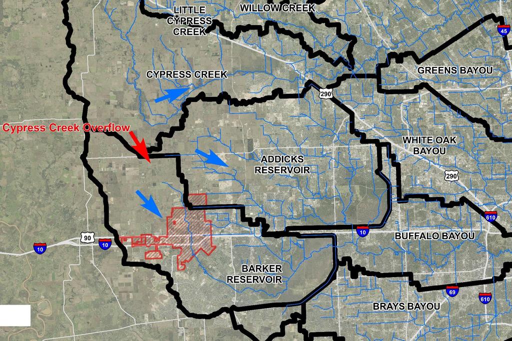
12 Cypress Creek Overflow Broad wide floodplain Shallow in nature Undefined overland flowpaths Begins around a 10 - year event Difficult to conventionally control as floodwaters cannot be easily collected

13 Cypress Creek Overflow Third Reservoir Cypress Creek Overflow Partner with other political and stakeholder groups City hosted meeting with US Representative Michael McCaul and other local leaders to discuss path forward Plan 5 proposed by HCFCD estimated to cost $369 million Anticipated to expand size of proposed reservoir for additional protection to Barker and Addicks

14 Short-Term Drainage Projects Update
 Review of pond drain time Proposed pond detention volume approx. 60 ac-ft")
15 Expanded City Regional Detention Pond Simulated expanded detention pond on city property Reviewed modifications to existing weir to improve performance Reviewed channel cleanout from Regional Pond to Morton Road (modified Manning s n-value from 0.08 to 0.04 to reflect a grass lined channel) Review of pond drain time Proposed pond detention volume approx. 60 ac-ft
16 Expanded City Regional Detention Pond OPTION Channel Clean Out Only (From Regional Pond to Morton) Existing Pond Modification (Lower Weir Elevation by approx. 4 feet) Existing Pond Modification with Channel Clearing Proposed Regional Pond with upstream weir Proposed Regional Pond, Inline Structure, Channel Clearing Proposed Regional Pond, Inline Structure, No Channel Cleanout Combination Existing Weir Adjustment, Regional Pond, Inline Structure, No Channel Cleanout RESULT (as measured at Morton Road) Rise of 0.21-feet Reduction of 0.1-feet Rise of 0.15-feet Reduction of 0.1-feet Reduction of 0.18-feet Reduction of 0.3-feet Reduction of 0.4-feet
17 Regional Pond Drain Time HCFCD Drain Time Requirement 1 day (24 hours) but can have up to 3 days (72 hours) Reports of extended drain time Shorter drain time reduces risk from back to back storms 3000-GPM pump station to drain pond in 3-days cost approximately $1M Drain Time (days) Existing Volume Proposed Volume 29.1 ac-ft 38.2 ac-ft Flow rates in GPM
18 Long Term Improvements Option Channel improvements expanded railroad and US 90 bridge Upstream regional detention (north of Pitts Road) Shared detention with Cane Island Branch development Key Assumptions All alternatives investigated for the 100-year storm event Assumes Cypress Creek Overflow is cutoff from Cane Island Branch Existing condition landuse

19 Channel Improvements Expand bridge under railroad and US 90 Channel improvements to increase depth and conveyance along creek Detention pond to mitigate impact due to improved conveyance Complex interactions with multiple agencies to make project viable (Railroad, City, TxDOT, HCFCD, FBCDD, USACE)

20 Channel Improvements Results Location Δ 100 Year Undetained Channel Improvements Δ 100 Year Detained Channel Improvements Pitts Road Clay Road Morton Road Franz Road th Street Highway Interstate Willow Fork

21 Upstream Regional Detention Regional detention pond to reduce peak water surface elevations within the City of Katy Evaluate range of Level of Service 1000, 1500, and 2000 acre-foot ponds

22 Upstream Regional Detention Δ 100 Year 500 ac-ft Pitts Detention Δ 100 Year 1000 ac-ft Pitts Detention Δ 100 Year 1500 ac-ft Pitts Detention Δ 100 Year 2000 ac-ft Pitts Detention Location Pitts Road Clay Road Morton Road Franz Road th Street Highway Interstate Willow Fork ,500 ac-ft Regional Pond

23 Shared Detention Pond with CIB Development Over excavate bottom of Cane Island Branch Detention Pond for regional volume Approx. 100 ac-ft of additional volume available Requires a 23,000 GPM Pump Station to drain pond in 24 hours. Additional Coordination and analysis required with developer and developer engineer Use side-weir to allow high flows to enter detention pond
24 Upstream Development Developed conditions upstream of Katy were analyzed Utilized a landuse assumption of small lot residential, this assumes a percent impervious value of 50%. Updated hydrology for developed conditions Simulated developed conditions without any detention volume Determined detention volume and rate to mitigate development

25 Upstream Development - Landuse

26 Upstream Development No Detention Input developed hydrology into HEC-RAS model Increase of water surface elevations of 1.4-feet within the City of Katy if no detention is provided Need to ensure upstream development detains to proper rate
27 Development Criteria Compute detention rate for range of landuse assumptions 40, 60, 80 % impervious and detention rate Peak flow rate limited to existing conditions which is approximately 0.5 cfs/acre based on existing condition hydrology Utilize Harris County Criteria Supplemental Criteria for development Flow (cfs) Development % Impervious Upstream Pitts Road Year Δ WSEL (No Improvements) Required Detention Rate (ac-ft/ac) Time (hr)
28 Development Criteria Harris County Criteria Supplemental Criteria for all development in Cane Island Branch watershed Min. detention rate of 0.55 ac-ft/ac Additional retention rate of 0.17 ac-ft/for residential and 0.32 ac-ft/ac for commercial Total rate of 0.72 to 0.87 ac-ft/ac for development Compensatory Floodplain Fill Mitigation Volume at 1:1 ratio Require developments to use City of Katy HEC-RAS 2D model (or approved alternative) to show floodplain fill mitigation volume is provided. Sheetflow Impacts Require developments to utilize the HEC-RAS 2D model to show no impact to the surrounding sheetflow on adjacent properties due to placement of fill. Partner with Brookshire-Katy Drainage District to create and enforce development regulations within the watershed
29 Emergency Response Inundation mapping for various rainfall amounts to allow for advanced planning of emergency response Identification of flooding zones based on predicted rainfall amounts Neighborhood level of service identified City can better plan resources based on predicted rainfall Develop map of road depths based on rainfall amounts Provide depth maps for roadways based on range of rainfall amounts Allow for emergency personnel to plan and react to predicate conditions

30 Emergency Response Inundation Mapping
31 Recommendations Continue with planned short term projects to improve local rainfall capacity within the city limits. Work with TxDOT and Union Pacific on possible expansion of the Railroad and US 90. Construct expanded city pond with improvements to the existing weir structure. Increase pump station size to provide further resiliency to the system. Coordinate with Cane Island Branch Engineer on possible opportunities to expand proposed detention pond for additional flood reduction. Continue to advocate for the third reservoir to protect from the Cypress Creek Overflow. Review localized drainage systems for opportunities to improve conveyance and stormwater collection within the city. Pine Forest Fortuna/Patna 1st Street Partner with Brookshire-Katy Drainage District to enforce consistent development criteria within the CIB watershed.
32 Flood Reduction Strategy Cypress Creek Third Reservoir (Plan 5, etc..) Cane Island Branch Creek Large scale regional improvements $$$$$$ channel improvements, regional detention City detention pond expansion Potentially expand CIB development pond Develop criteria and partner with BKDD to ensure responsible development upstream Local Drainage Pine Forest drainage improvements Fortuna/Patna drainage review 1st St. street and drainage improvements Morton Road drainage improvements Downtown storm sewer improvements

33 Pine Forest Drainage Review City authorized Costello, Inc. to look at alternatives to improve local drainage conditions within the Pine Forest subdivision. Planned workshop November 7 th with City Council to discuss the findings
DRAFT. Jacob Torres, P.E.; Nick Fang, Ph.D., P.E.
 \ Memorandum SSPEED Center at Rice University Department of Civil & Environmental Engineering 6100 Main MS-317 Houston, Texas 77005-1827 sspeed.rice.edu tel: 713-348-4977 To Andy Yung, P.E. CFM; Lane Lease,
APPENDIX IV. APPROVED METHODS FOR QUANTIFYING HYDROLOGIC CONDITIONS OF CONCERN (NORTH ORANGE COUNTY)
") APPENDIX IV. APPROVED METHODS FOR QUANTIFYING HYDROLOGIC CONDITIONS OF CONCERN (NORTH ORANGE COUNTY) Hydromodification design criteria for the North Orange County permit area are based on the 2- yr, 24-hr
APPENDIX IV. APPROVED METHODS FOR QUANTIFYING HYDROLOGIC CONDITIONS OF CONCERN (NORTH ORANGE COUNTY) Hydromodification design criteria for the North Orange County permit area are based on the 2- yr, 24-hr
Stormwater Management Studies PDS Engineering Services Division ES Policy # 3-01
 Stormwater Management Studies PDS Engineering Services Division Revised Date: 2/28/08 INTRODUCTION The City of Overland Park requires submission of a stormwater management study as part of the development
Chapter 6. Hydrology. 6.0 Introduction. 6.1 Design Rainfall
 6.0 Introduction This chapter summarizes methodology for determining rainfall and runoff information for the design of stormwater management facilities in the City. The methodology is based on the procedures
Project Drainage Report
 Design Manual Chapter 2 - Stormwater 2A - General Information 2A-4 Project Drainage Report A. Purpose The purpose of the project drainage report is to identify and propose specific solutions to stormwater
Rhode Island Stormwater Design and Installations Standards Manual
 Rhode Island Stormwater Design and Installations Standards Manual Public Workshop Required Management Volume Calculations and Redevelopment Considerations March 22, 2011 Presentation Outline Recap of How
iswm TM Technical Manual Hydrology:
 : 1.0 2.0 Downstream Assessment 3.0 Streambank Protection 4.0 Water Balance 5.0 Rainfall Tables 6.0 Hydrologic Soils Data Table of Contents 1.0... HO-1 1.1 Estimating Runoff... HO-1 1.1.1 Introduction
CRITERIA FOR STORMWATER DESIGN
 ..CHAPTER.. CRITERIA FOR STORMWATER DESIGN 2.1 Integrated Site Design Approach 2.1.1 Introduction This chapter represents the requirements, policies and other guidance for stormwater management design
COON CREEK WATERSHED DISTRICT PERMIT REVIEW. Spring Lake Park Schools Westwood Middle School st Avenue NE, Spring Lake Park, MN 55432
 PAN 16-112, Westwood Middle School, Page 1 of 6 COON CREEK WATERSHED DISTRICT PERMIT REVIEW MEETING DATE: August 22, 2016 AGENDA NUMBER: 10 FILE NUMBER: 16-112 ITEM: Westwood Middle School RECOMMENDATION:
Appendix B. Storm Drain System Data
 MENIFEE VALLEY CAMPUS MASTER PLAN FINAL EIR MT. SAN JACINTO COMMUNITY COLLEGE DISTRICT Appendix Appendix B. Storm Drain System Data June 2017 MENIFEE VALLEY CAMPUS MASTER PLAN FINAL EIR MT. SAN JACINTO
DIVISION 5 STORM DRAINAGE CRITERIA
 DIVISION 5 STORM DRAINAGE CRITERIA Section 5.01 GENERAL The following storm drainage design criteria shall apply to all storm drainage designs in the City. Additional design criteria are specified in the
CHAPTER 3 STORMWATER HYDROLOGY. Table of Contents SECTION 3.1 METHODS FOR ESTIMATING STORMWATER RUNOFF
 CHAPTER 3 STORMWATER HYDROLOGY Table of Contents SECTION 3.1 METHODS FOR ESTIMATING STORMWATER RUNOFF 3.1.1 Introduction to Hydrologic Methods...3.1-1 3.1.2 Symbols and Definitions...3.1-3 3.1.3 Rainfall
Evaluating Release Rates for Specific Watersheds in Cook County
 Evaluating Release Rates for Specific Watersheds in Cook County IAFSM March 8, 2017 Summary of MWRD Facilities 7 Water Reclamation Plants (including one of the worlds largest) ~ 554 Miles of Interceptors
FINDINGS: Olsson used a three-step analysis strategy to develop a benefit cost ratio that would indicate the relative feasibility of this project.
 EXECUTIVE SUMMARY FINDINGS: Based on the results of this feasibility study, the Platte Republican Diversion Project would be cost-effective. With minimal improvements to the channel, and the existing bridge
City of Tulsa. Stormwater Design Criteria Manual
 City of Tulsa Stormwater Design Criteria Manual 2014 Table of Contents Chapter 100 EXECUTIVE SUMMARY... 101 101 INTRODUCTION... 101 101.1 Manual Organization... 101 101.2 Manual Contents... 101 101.2.1
PRELIMINARY HYDROLOGY/HYDRAULICS ANALYSES RESULTS
 PRELIMINARY HYDROLOGY/HYDRAULICS ANALYSES RESULTS Coldstream Park Stream Corridor Restoration and Preservation Consent Decree SEP Prepared for Lexington-Fayette Urban County Government Division of Water
6.0 Runoff. 6.1 Introduction. 6.2 Flood Control Design Runoff
 October 2003, Revised February 2005 Chapter 6.0, Runoff Page 1 6.1 Introduction 6.0 Runoff The timing, peak rates of discharge, and volume of stormwater runoff are the primary considerations in the design
 ASHVILLE PARK STORMWATER UPDATE JULY 18, 2017 1 ASHVILLE PARK CHRONOLOGY 2005: Ashville Park conditionally rezoned. Consisted of Five Villages 2006-2007: Village A Wilshire Village was approved and construction
New Castle County, DE. Floodplain Regulations
 New Castle County, DE Floodplain Regulations John J. Gysling, PE CFM Department of Land Use New Castle County, DE February 26, 2009 Today s Presentation Floodplain Protection and Uses Terms and Definitions
Runoff Volume: The Importance of Land Cover
 Runoff Volume: The Importance of Land Cover Grade Level: 9-12 Time: 1-2 class periods Learning Objectives: - Quantify the volume of water that runs off different land uses in a watershed. - Analyze the
Pre-Treatment Bioretention Cells Bioswales IOWA STORMWATER MANAGEMENT MANUAL DECEMBER 16, 2015
 Pre-Treatment Bioretention Cells Bioswales IOWA STORMWATER MANAGEMENT MANUAL DECEMBER 16, 2015 Urban Runoff Background How we got here What Problem?? Provenance of the Problem Unified Sizing Criteria What
December 7, Dr. Christine Pomeroy University of Utah Civil and Environmental Engineering MCE Salt Lake City, UT. Dear Dr.
 December 7, 2012 Dr. Christine Pomeroy University of Utah Civil and Environmental Engineering MCE 2042 Salt Lake City, UT 84112 Dear Dr. Pomeroy, The following document is the final report of the Red Butte
PRINCESS ANNE DISTRICT STORMWATER PROJECTS
 PRINCESS ANNE DISTRICT STORMWATER PROJECTS Topics o o o o o Sea Level Rise and the Southern Watersheds Ashville Park Sherwood Lakes Kingston Estates Drainage Operations & Maintenance in the Southern Watersheds
Stormwater Local Design Manual For Houston County, Georgia
 Stormwater Local Design Manual For Houston County, Georgia Adopted November 15, 2005 TABLE OF CONTENTS 1. FORWARD... 1 2. GENERAL LEVEL OF SERVICE STANDARDS... 2 2.1. DETENTION REQUIREMENTS... 2 2.1.1.
Overview of NRCS (SCS) TR-20 By Dr. R.M. Ragan
 TR-20 By Dr. R.M. Ragan") Overview of NRCS (SCS) TR-20 By Dr. R.M. Ragan TR-20 is a computer program for the simulation of runoff occurring from a single storm event. The program develops flood hydrographs from runoff and routes
Overview of NRCS (SCS) TR-20 By Dr. R.M. Ragan TR-20 is a computer program for the simulation of runoff occurring from a single storm event. The program develops flood hydrographs from runoff and routes
ASHVILLE PARK STORMWATER UPDATE
 ASHVILLE PARK STORMWATER UPDATE JULY 18, 2017 1 ASHVILLE PARK CHRONOLOGY 2005: Ashville Park conditionally rezoned. Consisted of Five Villages 2006-2007: Village A Wilshire Village was approved and construction
2A Stormwater Regulations and Permitting A. Iowa Drainage Law and Resources 1 B. Regulated Activities 1
 Design Manual Chapter 2 - Stormwater Table of Contents TOC Table of Contents Chapter 2 - Stormwater 2A General Information 2A-1--------------------------------General Information A. Concept... 1 B. Informing
THE CROSSROADS IN WINCHESTER 4. DRAINAGE PLAN. 4. Drainage Plan. a. Drainage Plan Description
 THE CROSSROADS IN WINCHESTER 4. DRAINAGE PLAN 4. Drainage Plan a. Drainage Plan Description The Specific Plan area drains naturally into two separate watersheds: approximately 6 percent of the Specific
City of Dade City AMEC Project No Dade City Stormwater Master Plan September 2012 Page 11
 Page 11 1.0 INTRODUCTION This report was prepared for the City of Dade City to provide an overview of the existing stormwater management challenges that the City faces. The report is intended to assist
MODEL Stormwater Local Design Manual. City of Centerville
 MODEL Stormwater Local Design Manual City of Centerville Adopted December 6, 2005 TABLE OF CONTENTS 1. FORWARD... 1 2. GENERAL LEVEL OF SERVICE STANDARDS... 1 2.1. DETENTION REQUIREMENTS... 1 2.1.1. Discharge
STORMWATER AND EROSION CONTROL PERMIT
 STORMWATER MANAGEMENT AND EROSION CONTROL PERMIT INSTRUCTIONS AND INFORMATION Any project that involves the disturbance of ANY quantity of land requires the applicant to receive approval for the project
Village of Winnetka Flood Risk Reduction Assessment. Christopher B. Burke Engineering, Ltd. (CBBEL) October 11, 2011
 October 11, 2011") Village of Winnetka Flood Risk Reduction Assessment October 11, 2011 Christopher B. Burke Engineering, Ltd. (CBBEL) Thomas T. Burke, Jr., PhD, PE David Buckley, PE, CFM Introduction The September 2008
Village of Winnetka Flood Risk Reduction Assessment October 11, 2011 Christopher B. Burke Engineering, Ltd. (CBBEL) Thomas T. Burke, Jr., PhD, PE David Buckley, PE, CFM Introduction The September 2008
HEC-RAS 2D Modeling in Support of Ascension Parish Levee Certification
 HEC-RAS 2D Modeling in Support of Ascension Parish Levee Certification OFMA 2017 Annual Conference September 19, 2017 Presented by: Jeff Doudrick, PE, ENV SP Project Manager HNTB Corporation Agenda Project
Chapter 6 Hydrology TABLE OF CONTENTS CHAPTER 6 - HYDROLOGY
 Chapter 6 Hydrology TABLE OF CONTENTS CHAPTER 6 - HYDROLOGY... 6-1 6.1 Introduction... 6-1 6.1.1 Objective... 6-1 6.1.2 Definition... 6-1 6.1.3 Factors Affecting Floods... 6-1 6.1.4 Sources of Information...
UNIVERSITY OF OREGON NORTH CAMPUS CONDITIONAL USE PERMIT PROJECT Draft Conditional Use Permit Stormwater, Sanitary Sewer, and Water Analysis Report
 UNIVERSITY OF OREGON NORTH CAMPUS CONDITIONAL USE PERMIT PROJECT Draft Conditional Use Permit Stormwater, Sanitary Sewer, and Water Analysis Report Prepared for: Cameron McCarthy Landscape Architects LLP
SECTION 11: REGULATORY FLOODWAYS
 SECTION 11: REGULATORY FLOODWAYS Contents 11.1. The Floodway... 11-2 11.1.1. The floodway concept... 11-2 11.1.2. Floodway map... 11-2 11.1.3. Floodway permitting... 11-3 11.1.4. Changing the floodway...
Appendix G: Hydrology-Related Reports
 Appendix G: Hydrology-Related Reports (Hydraulic Summary of the Proposed Hawk Street Bridge, Bay Area Hydrology Model Project Report, Preliminary Stormwater Treatment Plan and Details, Evaluation of Potential
APPENDIX F HYDROLOGY REPORT
 APPENDIX F HYDROLOGY REPORT UCSD LONG RANGE DEVELOPMENT PLAN HYDROLOGY STUDY MAY 2004 PREPARED FOR: UNIVERSITY OF CALIFORNIA, SAN DIEGO 10280 NORTH TORREY PINES ROAD, SUITE 340 LA JOLLA, CA 92093-0965
Freight Street Development Strategy
 Freight Street Development Strategy Appendix B: Naugatuck River Floodplain Analysis Freight Street Development Strategy DECEMBER 2017 Page B-1 1.0 NAUGATUCK RIVER FLOODPLAIN AT FREIGHT STREET 1.1 Watershed
SECTION STORM DRAINAGE DESIGN, GRADING, AND WATER QUALITY TECHNICAL CRITERIA TABLE OF CONTENTS PAGE 402 STORM DRAINAGE DESIGN CRITERIA 400-1
 CITY OF THORNTON Standards and Specifications Revised: October 2012 SECTION 400 - STORM DRAINAGE DESIGN, GRADING, AND WATER QUALITY TECHNICAL CRITERIA TABLE OF CONTENTS PAGE 401 GENERAL PROVISIONS 400-1
Municipal Stormwater Ordinances Summary Table
 APPENDIX F Municipal Ordinances Summary Table Municipality Abington Bryn Athyn Borough Hatboro Borough Ordinance, SALDO Runoff equals pre post Erosion Sediment Control Water Quality Requirements Any which
CITY OF FRIENDSWOOD February 13, 2006 CLEAR CREEK WATERSHED PRELIMINARY NED ALTERNATIVES ANALYSIS
 CITY OF FRIENDSWOOD February 13, 2006 CLEAR CREEK WATERSHED PRELIMINARY NED ALTERNATIVES ANALYSIS Agenda Purpose Organizations/Entities Background Planning Process Preliminary NED Results Alternatives
Continuous Simulation Modeling of Stormwater Ponds, Lakes, & Wetlands: A BUILT-IN APPLICATION OF PONDS 3.2
 Continuous Simulation Modeling of Stormwater Ponds, Lakes, & Wetlands: A BUILT-IN APPLICATION OF PONDS 3.2 PRESENTED AT THE SFWMD WORKSHOP PRE-DEVELOPMENT VERSUS POST DEVELOPMENT RUNOFF VOLUME ANALYSIS
Time of Travel Study at Mason Park Final Report
 Mason Park Residence Time Study Final Report DRAFT Time of Travel Study at Mason Park Final Report Prepared in cooperation with the Harris County Flood Control District Project ID: Z100-00-00-Y053 EIH
APPENDIX G HYDRAULIC GRADE LINE
 Storm Drainage 13-G-1 APPENDIX G HYDRAULIC GRADE LINE 1.0 Introduction The hydraulic grade line is used to aid the designer in determining the acceptability of a proposed or evaluation of an existing storm
MEETING NOTICE & AGENDA VILLAGE BOARD COMMITTEE OF THE WHOLE. September 25, :10 p.m. Village Hall Council Chambers
 1200 Wilmette Avenue WILMETTE, ILLINOIS 60091 MEETING NOTICE & AGENDA VILLAGE BOARD COMMITTEE OF THE WHOLE September 25, 2017 7:10 p.m. Village Hall Council Chambers 1) Call to Order 2) Stantec Presentation
SW-74 SERENOVA PRESERVE SITES 2, 3, 4, 8 MITIGATION PLAN
 SW-74 SERENOVA PRESERVE SITES 2, 3, 4, 8 MITIGATION PLAN BACKGROUND INFORMATION Project SWIM? Aquatic Control? Exotic Control? Mitigation Bank? Type No No No No Mitigation Restoration and enhancement Type
Constructed Wetland Pond T-8
 Constructed Wetland Pond T-8 Description A constructed wetlands pond is a shallow retention pond designed to permit the growth of wetland plants such as rushes, willows, and cattails. Constructed wetlands
Table of Contents. 5-5 Release Rates Year Allowable Release Rate WQCV Release Rate EURV Release Rate...
 Chapter 5 Table of Contents 5-1 Introduction... 1 5-1-1 Stormwater Quality Considerations... 1 5-1-2 Stormwater Volume Considerations... 2 5-1-3 Downstream Impacts... 2 5-2 Requirements... 2 5-2-1 General
STORM WATER MANAGEMENT REPORT
 Silvercreek Junction STORM WATER MANAGEMENT REPORT Howitt Creek at the Silvercreek Parkway Site Guelph, Ontario August, 2008 TSH File 22304A-04 August 19, 2008 STORMWATER MANAGEMENT REPORT Howitt Creek
4.1 General Methodology and Data Base Development
 Chapter 4 METHODOLOGY 4.1 General and Data Base Development This report project utilized several computer software models and analysis techniques to create the numeric data on which decisions for this
NEW CASTLE CONSERVATION DISTRICT. through. (Name of Municipality) PLAN REVIEW APPLICATION DRAINAGE, STORMWATER MANAGEMENT, EROSION & SEDIMENT CONTROL
 PLAN REVIEW APPLICATION DRAINAGE, STORMWATER MANAGEMENT, EROSION & SEDIMENT CONTROL") NEW CASTLE CONSERVATION DISTRICT through (Name of Municipality) PLAN REVIEW APPLICATION DRAINAGE, STORMWATER MANAGEMENT, EROSION & SEDIMENT CONTROL Office use only: Received by Municipality: Received by
NEW CASTLE CONSERVATION DISTRICT through (Name of Municipality) PLAN REVIEW APPLICATION DRAINAGE, STORMWATER MANAGEMENT, EROSION & SEDIMENT CONTROL Office use only: Received by Municipality: Received by
Pennsylvania Stormwater Best Management Practices Manual. Section 3 Stormwater Management Principles, Goals, and a Management Model
 Pennsylvania Stormwater Best Management Practices Manual DRAFT - JANUARY 2005 Section 3 Stormwater Management Principles, Goals, and a Management Model This page intentionally left blank. Section 3 Stormwater
Urban Drainage Introduction. A.Ramachandra Rao. C.B. Burke. T.T. Burke, Jr.
 32 Urban Drainage A.Ramachandra Rao Purdue University C.B. Burke Christopher B. Burke Engineering, Ltd. T.T. Burke, Jr. Christopher B. Burke Engineering, Ltd. 32.1 Introduction 32.2 The Rational Method
DRAINAGE CRITERIA MANUAL (V. 1) RUNOFF
 RUNOFF") Section CONTENTS Page RO- 1.0 OVERVIEW... 1 2.0 RATIONAL METHOD... 3 2.1 Rational Formula... 3 2.2 Assumptions... 4 2.3 Limitations... 4 2.4 Time of Concentration... 5 2.4.1 Initial Flow Time... 5 2.4.2
Section CONTENTS Page RO- 1.0 OVERVIEW... 1 2.0 RATIONAL METHOD... 3 2.1 Rational Formula... 3 2.2 Assumptions... 4 2.3 Limitations... 4 2.4 Time of Concentration... 5 2.4.1 Initial Flow Time... 5 2.4.2
STORMWATER RUNOFF AND WATER QUALITY IMPACT REVIEW
 SUBCHAPTER 8 STORMWATER RUNOFF AND WATER QUALITY IMPACT REVIEW 7:45-8.1 Purpose and scope of review Except for those projects expressly exempted by this chapter or waived by the Commission, the Commission
Section 600 Runoff Table of Contents
 Section 600 Runoff Table of Contents 601 INTRODUCTION...600-1 602 RATIONAL METHOD...600-1 602.1 Rational Method Formula...600-2 602.2 Time of Concentration...600-2 602.3 Intensity...600-4 602.4 Runoff
THE WATER IS RISING SCALABLE, RELIABLE, AND RELEVANT INFORMATION SUPPORTING FIRST RESPONDERS. May 3, 2017
 THE WATER IS RISING SCALABLE, RELIABLE, AND RELEVANT INFORMATION SUPPORTING FIRST RESPONDERS May 3, 2017 Association of State Floodplain Managers 2017 Conference Jim Keith, PE, CFM Walter P Moore Andy
Chapter 1. Introduction
 Chapter 1 Introduction James P. Heaney, Robert Pitt, and Richard Field Introduction Stormwater has traditionally been considered a nuisance, requiring rapid and complete drainage from areas of habitation.
Pennsylvania Stormwater Best Management Practices Manual. Chapter 3. Stormwater Management Principles and Recommended Control Guidelines
 Pennsylvania Stormwater Best Management Practices Manual Chapter 3 Stormwater Management Principles and Recommended Control Guidelines 363-0300-002 / December 30, 2006 Chapter 3 Stormwater Management Principles
Municipal Stadium Wetland
 W A T E R S H E D F A C T S Total watershed area 140 mi 2 Average annual rainfall 38 in Average annual temperature 58 F Elevation Max 1321 ft Min 899 ft C. J. Brown Reservoir controls flow from 83 mi 2
Culvert Sizing procedures for the 100-Year Peak Flow
 CULVERT SIZING PROCEDURES FOR THE 100-YEAR PEAK FLOW 343 APPENDIX A: Culvert Sizing procedures for the 100-Year Peak Flow A. INTRODUCTION Several methods have been developed for estimating the peak flood
HYDROLOGY REPORT HEACOCK & CACTUS CHANNELS MORENO VALLEY, CALIFORNIA NOVEMBER 2005 REVISED APRIL 2006 REVISED AUGUST 2006
 HYDROLOGY REPORT HEACOCK & CACTUS CHANNELS MORENO VALLEY, CALIFORNIA NOVEMBER 2005 REVISED APRIL 2006 REVISED AUGUST 2006 RIVERSIDE COUNTY FLOOD CONTROL AND WATER CONSERVATION DISTRICT TABLE OF CONTENTS
CLARK COUNTY REGIONAL FLOOD CONTROL DISTRICT HYDROLOGIC CRITERIA AND DRAINAGE DESIGN MANUAL
 CLARK COUNTY REGIONAL FLOOD CONTROL DISTRICT HYDROLOGIC CRITERIA AND DRAINAGE DESIGN MANUAL SECTION 600 STORM RUNOFF TABLE OF CONTENTS 601 INTRODUCTION 603 601.1 - Basin Characteristics 603 602 TIME OF
City of Redwood City Stormwater Pollution Prevention Program. Drainage Guidelines for Residential Development
 City of Redwood City Stormwater Pollution Prevention Program Drainage Guidelines for Residential Development General Requirements A. Plot & Finished Grading Plan must be submitted with Building Permit
CACHE VALLEY STORM WATER DESIGN STANDARDS. As Amended by Logan City November 2010
 CACHE VALLEY STORM WATER DESIGN STANDARDS As Amended by Logan City November 2010 Updated November 2010 Table of Contents A. Definitions... 3 B. Design Requirements... 5 1. Storm Event... 5 2. Allowable
Fort Leonard Wood, Missouri. September 2013
 Fort Leonard Wood, Missouri September 2013 1 Presenters Shannon Kelly, Physical Scientist Clean Water Act Program Manager Directorate of Public Works Environmental Division Environmental Compliance Branch
5/11/2007. WinTR-55 for Plan Reviews Small Watershed Hydrology Overview
 WinTR-55 for Plan Reviews Small Watershed Hydrology Overview 1 Overview Course Outline Historical Background Program Description Model Capabilities and Limitations This is the Overview portion of the training.
Gwinnett County Stormwater System Assessment Program
 Gwinnett County Stormwater System Assessment Program Jonathan Semerjian, PE Dept. of Water Resources Stormwater Management Sam Fleming, PE Dewberry Presentation Overview Project Background Drivers Enhanced
Village of Mamaroneck Flood Mitigation Status Report
 Village of Mamaroneck Flood Mitigation Status Report Introduction Flooding is a regional problem that must be addressed with regional solutions; There are no quick-fix answers; This is an ongoing process;
Module 14: Small Storm Hydrology, Continuous Simulations and Treatment Flow Rates The Integration of Water Quality and Drainage Design Objectives
 Module 14: Small Storm Hydrology, Continuous Simulations and Treatment Flow Rates The Integration of Water Quality and Drainage Design Objectives Robert Pitt, Ph.D., P.E., DEE Department of Civil, Construction,
E. STORMWATER MANAGEMENT
 E. STORMWATER MANAGEMENT 1. Existing Conditions The Project Site is located within the Lower Hudson Watershed. According to the New York State Department of Environmental Conservation (NYSDEC), Lower Hudson
CITY OF DICKINSON DRAINAGE CRITERIA MANUAL. (Adopted August 23, 2011)
") CITY OF DICKINSON DRAINAGE CRITERIA MANUAL () I. INTRODUCTION Purpose This DRAINAGE CRITERIA MANUAL (the Manual ) provides design guidance for use by developers and engineers in preparation of drainage
CITY OF DICKINSON DRAINAGE CRITERIA MANUAL () I. INTRODUCTION Purpose This DRAINAGE CRITERIA MANUAL (the Manual ) provides design guidance for use by developers and engineers in preparation of drainage
Chapter 3 Calculating the WQCV and Volume Reduction
 Contents 1.0 Introduction... 1 2.0 Hydrologic Basis of the WQCV... 1 2.1 Development of the WQCV... 1 2.2 Optimizing the Capture Volume... 3 2.3 Attenuation of the WQCV (BMP Drain Time)... 4 2.4 Excess
Lyon Creek Cedar Way Stormwater Detention Dam Operation and Maintenance Manual
 Lyon Creek Cedar Way Stormwater Detention Dam Operation and Maintenance Manual Prepared by: Mike Shaw Stormwater Program Manager City of Mountlake Terrace January 2010 Section I General Information This
Chapter 12 Storage. Contents. Overview... 1
 Chapter 12 Storage Contents Overview... 1 Implementation of Regional, Sub-regional, and On-site Detention Facilities... 2 Regional Detention... 2 Subregional Detention... 5 Onsite Detention... 6 Detention
10.0 Storm Sewer Systems
 October 2003 Chapter 10.0, Storm Sewer Systems Page 1 10.0 Storm Sewer Systems 10.1 Introduction A storm sewer system consists of a system of inlets, pipes, manholes, junctions, cleanouts, outlets, and
SECTION 4 SURFACE WATER MANAGEMENT DESIGN AND CONSTRUCTION REQUIREMENTS
 SECTION 4 SURFACE WATER MANAGEMENT DESIGN AND CONSTRUCTION REQUIREMENTS Page 4-1 INTRODUCTION 4-3 4-1.01 Applicability of VMCs 14.24, 14.25, 14.26 4-4 4-1.02 Minimum Requirements - Projects Below Threshold
DRAINAGE PLAN OF NAU S EASTBURN EDUCATION AND GAMMAGE BUILDINGS FINAL PROPOSAL
 MAY 10, 2016 DRAINAGE PLAN OF NAU S EASTBURN EDUCATION AND GAMMAGE BUILDINGS FINAL PROPOSAL Connor Klein, Jiangnan Yi, Yuzhi Zhang, Yi Yang NORTHERN ARIZONA UNIVERSITY NAU Water Buffalo Engineering Table
REQUEST FOR QUALIFICATIONS FOR DAYTON VALLEY AREA DRAINAGE MASTER PLAN
 REQUEST FOR QUALIFICATIONS FOR DAYTON VALLEY AREA DRAINAGE MASTER PLAN Statement of Qualifications due Friday, November 3, 2017 at 12:00 PM (Pacific Time) To the Carson Water Subconservancy District Office
Summary of Detention Pond Calculation Canyon Estates American Canyon, California
 July 15, 2015 Bellecci & Associates, Inc Summary of Detention Pond Calculation Canyon Estates American Canyon, California 1. Methodology: Method: Unit Hydrograph Software: Bentley Pond Pack Version 8i
Ingham County Drain Commissioner Patrick E. Lindemann 707 BUHL AVENUE P. O. BOX 220 MASON MI PH. (517) FAX (517)
 FAX (517)") Date Issued Ingham County Drain Commissioner Patrick E. Lindemann 707 BUHL AVENUE P. O. BOX 220 MASON MI 48854 PH. (517) 676-8395 FAX (517) 676-8364 APPLICATION FOR SOIL EROSION AND SEDIMENTATION POLLUTION
Date Issued Ingham County Drain Commissioner Patrick E. Lindemann 707 BUHL AVENUE P. O. BOX 220 MASON MI 48854 PH. (517) 676-8395 FAX (517) 676-8364 APPLICATION FOR SOIL EROSION AND SEDIMENTATION POLLUTION
CITY OF REDLANDS MASTER PLAN OF DRAINAGE San Bernardino County, California
 CITY OF REDLANDS MASTER PLAN OF DRAINAGE San Bernardino County, California Prepared for City of Redlands 35 Cajon Street Redlands, California 92373 Prepared by 14725 Alton Parkway Irvine, CA 92618 Contact
CITY OF TROY DESIGN STANDARDS AND CONSTRUCTION SPECIFICATIONS
 CITY OF TROY DESIGN STANDARDS AND CONSTRUCTION SPECIFICATIONS PREPARED BY: F-7587 JANUARY 2010 TABLE OF CONTENTS SECTION 1 SECTION 2 SECTION 3 SECTION 4 SECTION 5 SECTION 6 APPENDIX ROADWAY DESIGN DRAINAGE
Appendix VI: Illustrative example
 Central Valley Hydrology Study (CVHS) Appendix VI: Illustrative example November 5, 2009 US Army Corps of Engineers, Sacramento District Prepared by: David Ford Consulting Engineers, Inc. Table of contents
Fargo-Moorhead Metropolitan Area Flood Risk Management Project
 Fargo-Moorhead Metropolitan Area Flood Risk Management Project 52ND ANNUAL IOWA ASCE ENVIRONMENTAL & WATER RESOURCES CONFERENCE 03 April 2014 Aaron W. Buesing Senior Hydraulic Engineer Corps of Engineers,
Outlet Structure Modeling
 Watershed Modeling using HEC-RAS Outlet Structure Modeling Jeff Wickenkamp, P.E., CFM, D.WRE Patrick Lach, P.E. Hey and Associates, Inc. Water Resources, Wetlands and Ecology Outline of Presentation Why
Stormwater Volume and Treatment Methods Simplifying the Numbers. IAFSM March 10, Presented by: Tom Powers P.E., CFM, LEED AP, CPESC
 Stormwater Volume and Treatment Methods Simplifying the Numbers IAFSM March 10, 2011 Presented by: Tom Powers P.E., CFM, LEED AP, CPESC Introduction GOALS: Improve understanding of Rate and Volume (Quantity)
Storm Sewer Design. Bob Pitt University of Alabama and Shirley Clark Penn State Harrisburg
 Storm Sewer Design Bob Pitt University of Alabama and Shirley Clark Penn State Harrisburg Major floods are dramatic and water flow routes must be recognized when minor drainage systems fail. These types
Prepared for Urban Drainage and Flood Control District
 BERM FAILURE TECHNICAL ANALYSES SOUTH PLATTE GRAVEL PIT EVALUATION CRITERIA Prepared for Urban Drainage and Flood Control District Wright Water Engineers, Inc. January 2013 121-030.000 TABLE OF CONTENTS
Hurricane Harvey. Fort Bend County Levee Improvement District No. 2
 Hurricane Harvey Fort Bend County Levee Improvement District No. 2 1 Outline for this evening s meeting 1. Introductions 2. Levee 101 3. What FBC LID 2 does and doesn t do 4. Development and capabilities
ROLES AND RESPONSIBILITIES Small Pond Approval. SWM MD-378 Pond Checklist Training 10/17/07. Exemptions EMBANKMENT HEIGHT. Height of Dam Weir Wall
 SWM MD-378 Pond Checklist Training 10/17/07 Ken Wolfe Warren Johnson USDA, NRCS Frederick, Maryland ROLES AND RESPONSIBILITIES Small Pond Approval MDE, WMA, Dam Safety Division Authority (COMAR 26.17.04.03)
The City of Cocoa (City) is located in east
 is located in east") FWRJ Reclaimed Water and Stormwater: A Perfect Pair to Meet Total Maximum Daily Load Wasteload Allocations? Danielle Honour, James Wittig, John A. Walsh, and Don Stevens Danielle Honour, P.E., D.WRE, and
FWRJ Reclaimed Water and Stormwater: A Perfect Pair to Meet Total Maximum Daily Load Wasteload Allocations? Danielle Honour, James Wittig, John A. Walsh, and Don Stevens Danielle Honour, P.E., D.WRE, and
Table of Contents. Overview... 1
 Chapter 3 Chapter 3 Table of Contents Overview... 1 Rainfall... 2 3-2-1 Rainfall Depths and Intensities... 2 3-2-2 Design Storm Distribution for Colorado Urban Hydrograph Procedure (CUHP)... 5 3-2-3 Temporal
Design-Build Capital Infrastructure Project
 Design-Build Capital Infrastructure Project US$60 Million Project Duration 2012 Responsible for drainage systems and construction QA-QC oversight and project documentation and as-built review and acceptance.
HYDROLOGIC MODELING CONSISTENCY AND SENSITIVITY TO WATERSHED SIZE
 HYDROLOGIC MODELING CONSISTENCY AND SENSITIVITY TO WATERSHED SIZE by James C.Y. Guo. Professor, Civil Engineering, U. Of Colorado at Denver, James.Guo@cudenver.edu.. And Eric Hsu, Project Engineer, Parson